Northeastern Naturalist Vol. 22, No. 3
T.W. Mayo, P.W.C. Paton, and P.V. August
2015
501
2015 NORTHEASTERN NATURALIST 22(3):501–512
Responses of Birds to Humans at a Coastal Barrier Beach:
Napatree Point, Rhode Island
Thomas W. Mayo1,*, Peter W.C. Paton2, and Peter V. August2
Abstract - Human activity is one of the most important factors affecting disturbance
to birds that use coastal barrier beaches in southern New England. The barrier beach at
Napatree Point, RI, provides important breeding habitat for several bird species, key stopover
habitat for thousands of migrating shorebirds, and is also a popular destination for
people. Anecdotal evidence suggested that walkers, joggers, dogs, and watercraft were
disrupting birds that foraged and roosted at this site. Our objectives were to characterize
the frequency and sources of disturbance to birds and use this information to develop
management recommendations to minimize the frequency of human disturbances to birds
at Napatree Point. We conducted 106 hours of observation from May through August in
2013. Of 211 flight responses, the most common sources of disturbance to birds were
beach walkers (57.8%), motorboats (8.5%), kayaks (8.5%), bird watchers (7.6%), and anglers
(6.2%). Birds typically flushed when pedestrians (e.g., walkers, bird watchers, and
anglers) were within 39 ± 24 m (median ± inter-quartile range) and watercraft (e.g., motorboats
and kayaks) were within 38 ± 33 m. Flight responses were positively correlated
with the number of people on the beach and the number of boats in the area. Disturbances
to birds peaked in July when human visitation was highest. Using a spatially explicit density
map of flight-initiation distance vectors, we identified the most important area to set
as a buffer zone for human access if managers seek to reduce the frequency of human disturbances
to birds at Napatree Point.
Introduction
Coastal barrier beaches in southern New England provide important habitat
for breeding and migrating bird species. Avian use of critical habitats such as
these can be impacted by a variety of anthropogenic factors (Glover et al. 2011,
Madsen 1995, Weston et al. 2012a). Birds typically exhibit a flight response when
approached by humans. The distance at which the response occurs varies among
species and various stimuli including pedestrians (Burger 1981, McLeod et al.
2013), watercraft activities (Peters and Otis 2006, Rodgers and Schwikert 2002),
and aircraft (Smit and Visser 1993). Previous research has shown that human
activities can effectively degrade habitat quality by directly disturbing breeding,
foraging, and roosting waterbirds (e.g., waterfowl, wading birds, and shorebirds),
with shorebirds demonstrated to be particularly vulnerable to human disturbance
(Brown et al. 2001; Burger 1981, 1986; Pfister et al. 1992). Detrimental effects
include reduced foraging rates and decreased use of foraging and roosting sites
1Masters of Environmental Science and Management Program, University of Rhode Island,
Kingston, RI 02881. 2Department of Natural Resources Science, University of Rhode Island,
Kingston, RI 02881. *Corresponding author - tmayo@portsmouthwater.org.
Manuscript Editor: Greg Roberston
Northeastern Naturalist
502
T.W. Mayo, P.W.C. Paton, and P.V. August
2015 Vol. 22, No. 3
(Fitzpatrick and Bouchez 1998, Thomas et al. 2003) and the disruption of essential
breeding behaviors (Weston and Elgar 2005, 2007).
In New Jersey, Burger (1986) found that 40% of the disturbances to shorebirds
were from people walking on the beach, with anglers accounting for 10–20% of
disturbances. Indeed, understanding which stimuli are present in an environment
and at what density they occur is important because birds respond to different anthropogenic
stimuli (e.g., walkers, cars, boats) at different rates or distances (Glover
et al. 2011, McLeod et al. 2013). There can also be a strong seasonal component to
disturbances (Stillman and Goss-Custard 2002), with Burger (1986) documenting
the highest rates of disturbance in May and August, when most migrating shorebirds
are present and human use of beaches also tends to peak in the northeastern US.
There is also interspecific variation in response to disturbance, with larger shorebirds
(and birds in general) flushing at greater distances than smaller shorebirds in
response to similar disturbances (Koch and Paton 2014, Weston et al. 2012a).
Napatree Point in southwestern Rhode Island is a local hotspot for breeding and
migratory birds, with 1 federally listed species, Charadrius melodus (Piping Plover),
and 3 state-listed species—Haematopus palliatus (American Oystercatcher),
Sternula antillarum (Least Tern), and Pandion haliaetus (Osprey)—regularly
nesting on the barrier beach. In addition, numerous shorebirds (e.g., sandpipers,
Sterna spp. [terns], Larus spp. [gulls]) and waterbirds (e.g., Phalacrocorax spp.
[cormorants], egrets, waterfowl) congregate at Napatree Point during spring and
fall migration. Scientists from the US Fish and Wildlife Service make regular trips
throughout the year to conduct bird surveys of the area, and Watch Hill Conservancy
staff conduct weekly surveys. Because of the relatively large numbers of birds that
forage and roost in this area, naturalists often visit the lagoon to search for rare
birds. On warm summer days, over 1000 people and 300 boats have been recorded
at Napatree Point (Sassi 2013). The beach on the southern side of Napatree Point is
a popular destination for beach enthusiasts, while several hundred boats often moor
overnight to the northeast of the lagoon in southern Little Narragansett Bay, particularly
on weekends in July and August (Sassi 2013). Thus, there is high potential for
humans to have a negative impact on avian use of Napatree Point.
Our objectives were to (1) quantify the various sources of human disturbance
to birds (e.g., walker, angler, or bird watcher) using the lagoon at Napatree Point,
(2) assess interspecific variation in flight responses among various sources of human
stimuli by measuring the distance between the disturbance stimuli and the disturbed
bird (Blumstein et al. 2003), and (3) use these data to develop recommendations to
inform resource managers at Napatree Point on how best to minimize disturbance
to resident and migratory shorebirds and waterbirds.
Methods
Study site
We conducted fieldwork in the Napatree Point Conservation Area (NPCA, hereafter
Napatree Point), a 2.4-km-long x 100–300-m-wide (27.7 ha) barrier beach
located in the village of Watch Hill, Westerly, RI (Fig. 1). This barrier beach is
Northeastern Naturalist Vol. 22, No. 3
T.W. Mayo, P.W.C. Paton, and P.V. August
2015
503
bounded to the north by Little Narragansett Bay and to the south by the Atlantic
Ocean. Napatree Point is a biological preserve that is owned and managed by the
Watch Hill Fire District and the Watch Hill Conservancy (Westerly, RI). Terrestrial
habitats present include maritime shrubland, salt marsh, maritime beach strand, and
maritime herbaceous dune (Enser et al. 2011). A 5.2-ha tidal lagoon and adjacent
sandy beaches provide breeding habitat for Limulus polyphemus L. (Horseshoe
Crab), whose eggs are a vital food resource for migratory shorebirds (Gillings et al.
2007). The lagoon and adjacent areas also have extensive Mytilus edulis L. (Blue
Mussel) and Zostera marina L. (Marine Eelgrass) beds that offer key foraging habitat
for shorebirds and waterbirds; therefore, this area is one of the most important
biodiversity hotspots in the region.
Avian surveys
One observer (T.W. Mayo) conducted all surveys from a fixed point, surrounded
by 0.5-m-tall Ammophila breviligulata Fern. (American Beachgrass), keeping well
hidden in the dunes 115 m from the eastern edge of the lagoon (Fig. 1). This fixed
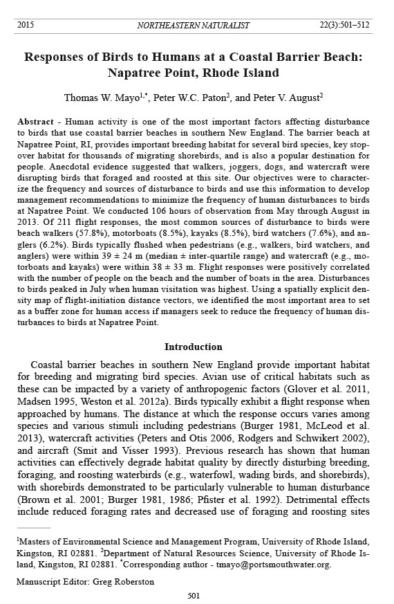
Figure 1. Map of the Napatree Point Conservation Area, the peninsula extending out from
Watch Hill, RI. (A) Regional map showing the location of the study area (indicated by a
circle). (B) Map of Napatree Point. The boundary of the Napatree Point Conservation Area
is shown in the bold outline. (C) Observation zone for this study. The location of the observer
(+) and locations of flocks (●) that were disturbed during observa tions are shown.
Northeastern Naturalist
504
T.W. Mayo, P.W.C. Paton, and P.V. August
2015 Vol. 22, No. 3
point was far enough from foraging and roosting birds to prevent disturbance while
simultaneously allowing the observer to quantify when birds were flushed by anthropogenic
sources within the study-area boundaries. These boundaries extended
from the western edge of the lagoon to the first abandoned Osprey nest pole east
of the vantage point. All disturbances witnessed were within the observation zone
shown in Figure 1C; disturbances witnessed outside of the observation zone were
not recorded. T.W. Mayo used a 60x spotting scope and 10 x 42 binoculars to make
observations from 09:00 to 16:00 on weekends and holidays, when human visitation
rates were highest. He completed observations under all weather conditions except
during inclement weather (heavy rains and thunderstorms) that shortened some of
the observation periods.
The observer counted potential sources of anthropogenic disturbance (i.e., pedestrians,
watercraft, or aircraft) and weather information (i.e., air temperature,
wind speed, and percent cloud-cover in 25% increments) every 30 min within
the observation zone. He categorized watercraft as a motorboat, sailboat, canoe/
kayak, paddleboard, or jet ski; and pedestrians as a walker (walking only), jogger
(obviously running), birder (actively using binoculars or a spotting scope), angler
(carrying a fishing rod or actively fishing), or ATV (driving in an all-terrain vehicle,
which was restricted to management staff because no other vehicles are allowed on
Napatree Point). We categorized aircraft as a helicopter, airplane (always singleengine
fixed-wing craft), or a kite on a string.
Each time an individual bird or flock of birds took flight within the observation
zone, the observer recorded the location of the anthropogenic-disturbance stimulus
and the species and location of the bird(s) that flushed. These locations were
recorded in the field on an analog map of the study zone. We employed ArcGIS (Environmental
Systems Research Institute, v10.2 software, Redlands, CA) to create
analog maps developed from high-resolution (10-cm pixel size) digital orthophotography.
We identified from the orthophotography or with GPS coordinates (less than 3 m
horizontal accuracy) permanent beach landmarks, coastline, and natural features as
reference points on the analog map. There were enough reference features on the
analog map to accurately locate disturbance events on the ground to within ~5–10
m. We could not accurately map the exact location of airborne sources of disturbance
because of the lack of spatial reference in the sky and the speed with which
aircraft moved.
We recorded whether the disturbance source caused flight responses by individual
or multiple birds and, when possible, recorded the species that were flushed. This
identification was relatively easy when individual birds flushed but was difficult
when a large, multispecies flock flushed at once. Because our study design was based
on observations of naturally occurring human disturbances and the concomitant
flight responses in birds, we did not experimentally create stimuli to disturb birds.
To determine flight-initiation distances (Blumstein et al. 2003), we scanned the
analog maps recorded in the field into digital image format, georegistered the digital
images, and converted bird locations when initially flushed and their corresponding
disturbance source to point-features in a GIS. In order to display the spatial pattern
Northeastern Naturalist Vol. 22, No. 3
T.W. Mayo, P.W.C. Paton, and P.V. August
2015
505
of disturbance stimuli and where birds were when they responded, we performed a
number of GIS-based analyses. For each disturbance event, we created a line vector
that extended from the first bird flushed to the source of disturbance. The length of
the vector represented the flight-initiation distance (FID) between the flushed bird
and the disturbance source. We mapped these vectors to provide a visual representation
of the spatial distribution of disturbances in and around the lagoon.
We used the default kernel-density algorithm in ArcGIS v 10.2 software to create
a density map (meters of disturbance vector per km2) of disturbance vectors.
To develop a spatially-explicit management zone to protect nesting, foraging, and
roosting shorebirds and waterbirds at Napatree Point, we extracted the top 50%
(i.e., greater than the median disturbance density) of areas in the disturbance-density
map to determine where most disturbance events took place. By buffering this
area by 40 m, the recommended additional buffer by Rodgers and Smith (1995),
we established a management zone where pedestrians and watercraft were likely to
intrude in the highest disturbance-density area (Fig. 2). We excluded disturbances
caused by aircraft from the density analysis because they were not ground-based
events and we could not map their locations as accurately as disturbances that occurred
on the ground.
We conducted all statistical analyses using Microsoft Excel and R software (R
Core Team 2013). Results of a Shapiro-Wilk test showed that our data were not
Figure 2. The spatial distribution of disturbance events around the lagoon in the Napatree
Point Conservation Area during 2013. Left panel shows vectors depicting locations
of anthropogenic stimuli and the closest disturbed avian flock. Right panel is a density
map of the disturbance vectors. We classified disturbance vectors into approximate
quartiles of disturbance density that are expressed as meters of disturbance vector per
square kilometer (m/km2). The broken line is a 40-m buffer away from the top 50% of
disturbance densities.
Northeastern Naturalist
506
T.W. Mayo, P.W.C. Paton, and P.V. August
2015 Vol. 22, No. 3
normally distributed; therefore, we used non-parametric Spearman rank-correlation
tests to measure dependence among variables.
Results
We detected a total of 211 disturbance events during 106 hours of observation
(average = 1.99 disturbances per hour) over 21 days of field observations from mid-
May to late-August 2013. We detected an average of 11 ± 9 (median ± interquartile
range, absolute range = 3–19) disturbance events per observation day, peaking from
early to mid-August. The frequency of disturbances (disturbances per observation
hour/day) tended to increase as weather became warmer (mean temperature; Spearman
r = 0.43, P < 0.06), and when pedestrian use of the observation zone increased
(number visitors/day; Spearman r = 0.76, P < 0.001, n = 19, Fig. 3). We counted a
total of 2779 pedestrians during the 30-min observation windows on 19 of the 21
days of sampling; no pedestrian or watercraft counts were done in May. On average,
we observed 28.9 pedestrians per hour per day, with the highest human-activity
rates between 12:00 and 14:30; indeed, 97% of all disturbance events occurred
between the hours of 10:00 and 15:00. We counted a total of 2936 watercraft (primarily
motorboats) during the study. We found a significant positive correlation
between the number of watercraft and pedestrian counts (Spearman r = 0.82, P less than
0.001, n = 19, Fig. 3).
Disturbances to birds were caused most often by people walking along the beach
(57.8%), motorboats (8.5%), kayakers (8.5%), birders (7.6%), aircraft (6.6%), and
anglers (6.2%) (Table 1). Single-disturbance events caused multiple flocks to flush
slightly more often than they caused a single flock to flush (114 and 97 disturbances,
respectively; Table 1). Multiple disturbances typically occurred when a jogger,
birder, or walker continued to travel along the shore or lagoon edge, whereas single
disturbances typically occurred when a walker approached the lagoon and then
decided to turn back. Stationary disturbances (e.g., anglers) generally caused fewer
multiple flushes (Table 1).
We documented disturbances to 25 avian species, with Larus argentatus (Herring
Gull), Sterna hirundo (Common Tern), Least Tern, and American Oystercatcher
the most frequently disturbed species (Appendix 1). We documented 16
occasions when Piping Plovers (federally listed as threatened), and 15 occasions
when Sterna dougallii (Roseate Tern; federally listed as endangered) were flushed
(Appendix 1). The FID was greatest for aircraft (median distance = 117.5 m) and
lowest for pedestrians and watercraft (38.7 m and 38.4 m, respectively; Table 1).
Disturbances were concentrated at the entrance to the lagoon, where large numbers
of birds and disturbance stimuli (walkers, birders, and boats) tended to congregate
(Fig. 2).
Discussion
Previous research has shown that human disturbance can have negative impacts
on migratory-bird use of a coastal stopover site (Pfister et al. 1992, Thomas et al.
Northeastern Naturalist Vol. 22, No. 3
T.W. Mayo, P.W.C. Paton, and P.V. August
2015
507
2003); therefore, we were interested in relationships between anthropogenic stimuli
and bird responses at Napatree Point. We found that pedestrians walking along the
Figure 3. Relationship between the daily total number of people observed at Napatree Point
Conservation Area and the number of boats anchored or moving through the site (A) and
between disturbance rates (disturbances per day) and visitors per day (B). Spearman rank
correlations were used to calculate r values (n = 19 days).
Northeastern Naturalist
508
T.W. Mayo, P.W.C. Paton, and P.V. August
2015 Vol. 22, No. 3
beach and the eastern edge of the lagoon accounted for approximately 75% of all
bird-disturbance events, which was similar to previous research on coastal barrier
beaches (Burger 1986, Lafferty 2001) and beaches worldwide (Weston and Elgar
2005, 2007), except where vehicles dominated (Schlacher et al. 2013). In general, we
found that birds were less likely to flush when approached by a slow-moving pedestrian,
such as a person actively fishing (i.e., anglers), compared to an active jogger or
walker, a result which concurred with past research (Burger 1981, Glover et al. 2011).
Other studies have shown that, compared to people walking alone, people walking
dogs can have a greater impact on bird responses at a beach (Thomas et al. 2003)
and longer FIDs (Glover et al. 2011), but dogs were only observed near the lagoon
on 2 occasions during this study. In both cases, it was our subjective assessment that
the people accompanying the dogs appeared to be the source of disturbance and not
the pets. In one instance, the dog was leashed, while in the other, the dog was freerunning.
An active campaign by NPCA staff to alert beach enthusiasts that dogs are
prohibited on Napatree Point by town ordinance from 8:00 AM to 17:00 PM during
the summer apparently has been quite effective (unlike many other efforts to manage
dogs on beaches; Williams et al. 2011). However, boaters and local beach enthusiasts
often walk their dogs in the conservation area in the early morning hours when many
Table 1. Sources and relative frequency of disturbances to birds at the Napatree Point Conservation
Area Lagoon. Multiple flushes occur when 1 source of disturbance causes multiple flocks of birds
to flush their foraging or resting grounds at different times or cause a single flock to flush more
than once. Each distinct disturbance event per source was counted separately. Number - number of
distrubance events; % total = percent total disturbances; % multiple = percent of disturbance type
causing multiple flushes
Median (25th percentile, 75th percentile)
of distance (m) between
Type of disturbance Number % total % multiple disturbance and flushed birds
Pedestrians
Total 157 74.4 59.2 38.7 (27.7, 51.7)
Bird watchers 16 7.6 62.5 32.8 (26.6, 48.8)
Anglers 13 6.2 46.2 41.1 (39.1, 54.4)
Jogger 5 2.4 80.0 32.6 (28.4, 61.5)
Walker 122 57.8 59.0 37.7 (27.8, 51.2)
ATV 1 0.5 100.0
Watercraft
Total 40 19.0 40.0 38.4 (29.7, 62.6)
Motorboat 18 8.5 38.9 38.4 (29.6, 52.9)
Sail boat 1 0.5 100.0
Kayak/canoe 18 8.5 38.9 45.5 (29.8, 61.8)
Jet ski 1 0.5 0.0
Paddleboard 2 0.9 50.0
Aircraft
Total 14 6.6 35.7 117.6 (86.6, 141.4)
Helicopter 4 1.9 75.0 95.0 (82.0, 112.6)
Kite 1 0.5 0.0
Airplane 9 4.3 22.2 135.0 (89.8, 157.3)
Northeastern Naturalist Vol. 22, No. 3
T.W. Mayo, P.W.C. Paton, and P.V. August
2015
509
birds are actively foraging; thus, we are concerned that dogs are not banned on the
beach 24 hours per day to minimize disturbance to birds using this key habitat (Burger
1986, Burger et al. 2004).
Estimates of FID have significant ramifications for management of shorebird
and waterbird breeding and stopover habitat (Blumstein et al. 2003, Koch and
Paton 2014, Rodgers and Smith 1995, Weston et al. 2012a). The median FID we
documented when birds were disturbed by walkers or boats (~40 m) is similar to
distances reported in previous studies (e.g., Blumstein 2003, Burger and Gochfeld
1991, Thomas et al. 2003), but less than values reported for some larger species of
shorebirds documented in other areas (e.g., Koch and Paton 2014), perhaps due to
different methods of observation and analysis between studies. The disturbancedensity
map we developed provides guidance for Napatree Point resource managers
on possible regions from which pedestrians and boats should be excluded during
migration periods and breeding season in order to reduce disturbance to birds (Ikuta
and Blumstein 2003, Rodgers and Smith 1995).
An area to the east of the lagoon is generally fenced off most years with symbolic
fencing and signage to prevent people from entering Piping Plover nesting
areas, which is a standard operating procedure for Rhode Island beaches where
this threatened species nests (Melvin et al. 1991). Such fencing appears associated
with high compliance in some international beaches (Weston et al. 2012b). We
propose placement of symbolic fencing and signage around our buffered protection
zone (Fig. 2) so that foraging, roosting, and nesting shorebirds and waterbirds
would be protected from anthropogenic disturbance sources. We have no easy way
to reduce aircraft disturbance to the site, but based on our surveys, aircraft do not
appear to have a major impact on birds at Napatree Point. Elsewhere throughout
the region, kite-boarders are becoming a disturbance source at migratory stopover
locations, but this recreational activity is currently not prevalent at Napatree Point.
Furthermore, understanding the hourly pattern of disturbances to birds is helpful to
managers. Stationing beach patrols and naturalists near the lagoon between 12:00
PM and 14:30 on warm weekend days to educate pedestrians and boaters about this
significant resource could be the most effective opportunity to teach beach patrons
of the importance of minimizing disturbance to wildlife.
Acknowledgments
We would like to thank the NPCA naturalist team for general support in the implementation
of this study. Janice Sassi, the NPCA Manager, provided logistic support, moral
support, and generously shared her knowledge of the Napatree ecosystem. Jessica Cressman,
Kevin Rogers, and Jesse Malo provided field assistance and conservation knowledge.
Steve Brown provided various supplies and many thoughtful brainstorming sessions with
us. The Watch Hill Fire District and Watch Hill Conservancy allowed the use of their parking
resources and ATV for transiting out to the study site. Grant Simmons (Watch Hill Fire
District) and the late Chaplin B. Barnes (Watch Hill Conservancy) provided inspiration,
support, and encouragement throughout the study. This research was funded, in part, by a
Dean’s Grant from the URI MESM program. This publication was supported by the Rhode
Island Agricultural Experiment Station through funding from the National Institute of Food
Northeastern Naturalist
510
T.W. Mayo, P.W.C. Paton, and P.V. August
2015 Vol. 22, No. 3
and Agriculture, United States Department of Agriculture, Hatch activities. The thoughtful
comments by two anonymous reviewers significantly improved the c larity of the paper.
Literature Cited
Blumstein, D.T. 2003. Flight-initiation distance in birds is dependent on intruder-starting
distance. Journal of Wildlife Management 67:852–857.
Blumstein, D.T., L.L. Anthony, R. Harcourt, and G. Ross. 2003. Testing a key assumption
of wildlife buffer zones: Is flight-initiation distance a species-specific trait? Biological
Conservation 110:97–100.
Brown, S.C., C. Hickey, B. Harrington, and R. Gill (Eds.). 2001. The US Shorebird Conservation
Plan. 2nd Edition. Manomet Center for Conservation Sciences, Manomet, MA.
50 pp.
Burger, J. 1981. The effect of human activity on birds at a coastal bay. Biological Conservation
21:231–241.
Burger, J. 1986. The effect of human activity on shorebirds in two coastal bays in northeastern
United States. Environmental Conservation 13:123–130.
Burger, J., and M. Gochfeld. 1991. Human distance and birds: Tolerance and response distance
of resident and migrant species in India. Environmental Conservation 18:158–165.
Burger, J., C. Jeitner, K. Clark, and L.J. Niles. 2004. The effect of human activities on
migrant shorebirds: Successful adaptive management. Environmental Conservation
4:283–288.
Enser, R., D. Gregg, C. Sparks, P. August, P. Jordan, J. Coit, C. Raithel, B. Tefft, B. Payton,
C. Brown, C. LaBash, S. Comings, and K. Ruddock. 2011. Rhode Island ecological
communities classification. Technical Report. Rhode Island Natural History Survey,
Kingston, RI. 33 pp.
Fitzpatrick, S., and B. Bouchez. 1998. Effects of recreational disturbance on the foraging
behavior of waders on a rocky beach. Bird Study 45:157–171.
Gillings, S., P.W. Atkinson, S.L. Bardsley, N.A. Clark, S.E. Love, R.A. Robinson, R.A.
Stillman, and R.G. Weber. 2007. Shorebird predation of Horseshoe Crab eggs in Delaware
Bay: Species contrasts and availability constraints. Journal of Animal Ecology
76:53–414.
Glover, H.K., M.A. Weston, G.S. Maguire, K.K. Miller, and B.A. Christie. 2011. Towards
ecologically meaningful and socially acceptable buffers: Response distances of shorebirds
in Victoria, Australia, to human disturbance. Landscape and Urban Planning
103:326–334.
Ikuta, L.A., and D.T. Blumstein. 2003. Do fences protect birds from human disturbance?
Biological Conservation 112:447–452.
Koch, S.L., and P.W.C. Paton. 2014. Assessing anthropogenic disturbances to develop buffer
zones for shorebirds using a stopover site. Journal of Wildlife Management 78:58–67.
Lafferty, K.D. 2001. Birds at a southern California beach: Seasonality, habitat use, and disturbance
by human activity. Biodiversity and Conservation 10:1949–1962.
Madsen, J. 1995. Impacts of disturbance on migratory waterfowl. Ibis 137:S67–S74.
McLeod, E.M., P.-J. Guay, A.J. Taysom, R.W. Robinson, and M.A. Weston. 2013. Buses,
cars, bicycles, and walkers: The influence of the type of human transport on the flight
responses of waterbirds. PLoS ONE 8(12): e82008. doi:10.1371/journal.pone.0082008.
Melvin, S.M., C.R. Griffin, and L.H. MacIvor. 1991. Recovery strategies for Piping Plovers
in managed coastal landscapes. Coastal Management 19:21–34.
Northeastern Naturalist Vol. 22, No. 3
T.W. Mayo, P.W.C. Paton, and P.V. August
2015
511
Peters, K.A., and D.L. Otis. 2006. Wading-bird response to recreational boat traffic: Does
flushing translate into avoidance? Wildlife Society Bulletin 34:1383–1291.
Pfister, C., B.A. Harrington, and M. Levine. 1992. The impact of human disturbance on
shorebirds at a migration-staging area. Biological Conservation 60:115–126.
R Core Team. 2013. R: A language and environment for statistical computing. R. Foundation
for Statistical Computing, Vienna, Austria. Available online at http://www.R-project.org.
Rodgers, J.A., and S.T. Schwikert. 2002. Buffer-zone distances to protect foraging and
loafing waterbirds from disturbance by personal watercraft and outboard-powered boats.
Conservation Biology 16:216–24.
Rodgers, J.A., and H.T. Smith. 1995. Set-back distances to protect nesting-bird colonies
from human disturbance in Florida. Conservation Biology 9:89–99.
Sassi, J. 2013. The state of Napatree report. Watch Hill Conservancy, Watch Hill, RI. 51 pp.
Schlacher, T.A., T. Nielsen, and M.A. Weston. 2013. Human recreation alters behavior
profiles of non-breeding birds on open-coast sandy shores. Estuarine, Coastal, and Shelf
Science 118:31–42.
Smit, C.J. and G.J.M. Visser. 1993. Effect of disturbance on shorebirds: A summary of
existing knowledge from the Dutch Wadden Sea and Delta area. Wader Group Study
Bulletin 68:6–19.
Stillman, R.A., and J.D. Goss-Custard. 2002. Seasonal changes in the response of Oystercatchers
(Haematopus ostralegus) to human disturbance. Journal of Avian Biology
33:358–65.
Thomas, K., R.G. Kvitek, and C. Bretz. 2003. Effects of human activity on the foraging
behavior of Sanderlings, Calidris alba. Conservation Biology 109:67–71.
Weston M.A., and M.A. Elgar. 2005. Disturbance to brood-rearing Hooded Plover (Thinornis
rubricollis): Responses and consequences. Bird Conservation International
15:193–209.
Weston M.A., and M.A. Elgar. 2007. Responses of incubating Hooded Plovers (Thinornis
rubricollis) to disturbance. Journal of Coastal Research 23:569–576.
Weston, M.A., E.M. McLeod, D.T. Blumstein, and P.-J. Guay. 2012a. A review of flightinitiation
distances and their application to managing disturbances to Australian birds.
Emu 112:269–286.
Weston, M.A., F. Dodge, A. Bunce, D.G. Nimmo, and K.K. Miller. 2012b. Do temporary
beach closures assist in the conservation of breeding shorebirds on recreational beaches?
Pacific Conservation Biology 18:47–55.
Williams, K.J.H., M.A. Weston, S. Henry, and G.S. Maguire. 2009. Birds and beaches,
dogs, and leashes: Dog owners’ sense of obligation to leash dogs on beaches in Victoria,
Australia, Human Dimensions of Wildlife 14:89–101.
Northeastern Naturalist
512
T.W. Mayo, P.W.C. Paton, and P.V. August
2015 Vol. 22, No. 3
Appendix 1. Interspecific variation in the total number of disturbance events by various anthropogenic stimuli at Napatree Point Conservation Area during
2013.
Aircraft Pedestrians Watercraft
Heli- Motor Kayak/ Paddle- Sail
Species copter Kite Plane ATV Birder Angler Runner Walker boat canoe board boat n
Haematopus palliatus Temminck (American Oystercatcher) 1 1 5 6 4 2 41 4 3 67
Gavia imer (Brünnich) (Common Loon) 1 1 1 2 1 6
Phalacrocorax auritus (Lesson) (Double-crested Cormorant) 2 5 2 2 10 5 2 1 1 30
Egretta thula (Molina) (Snowy Egret) 1 1 2 1 12 3 20
Ardea alba L.(Great Egret) 1 4 1 6
Pandion haliaetus L. (Osprey) 2 1 1 3 1 1 9
Pluvialis squatarola L. (Black-bellied Plover) 1 1 2 1 3 2 9 1 2 22
Charadrius semipalmatus Bonaparte (Semipalmated Plover) 1 1 3 2 3 6 1 17
Charadrius melodus Ord (Piping Plover) 1 1 2 2 1 9 16
Actitis macularius L. (Spotted Sandpiper) 3 3
Tringa semipalmata (Gmelin) (Willet) 1 3 1 10 15
Arenaria interpres (L.) (Ruddy Turnstone) 1 1 2 2 4 1 13 2 26
Calidris alba (Pallas) (Sanderling) 1 1 2 12 2 2 20
Calidris canutus (L.) (Red Knot) 1 1 4 6
Calidris alpina (L.) (Dunlin) 1 1
Calidris pusilla (L.) (Semipalmated Sandpiper) 3 3
Limnodromus griseus (Gmelin) (Short-billed Dowitcher) 1 3 4
Larus smithsonianus Coues (American Herring Gull) 1 1 6 5 7 2 56 9 7 1 1 96
Larus marinus L. (Great Black-backed Gull) 1 2 2 1 16 1 1 1 1 26
Sterna hirundo L. (Common Tern) 2 6 1 7 4 3 52 7 8 1 1 92
Sterna dougallii Montagu (Roseate Tern) 1 1 1 9 1 1 1 15
Sternula antillarum Lesson (Least Tern) 2 1 6 1 9 4 3 53 4 7 1 1 92
Rhynchops niger L. (Black Skimmer) 1 1 1 2 4 9
Hirundo rustica L. (Barn Swallow) 1 2 3
Aegelaius phoeniceus (L.) (Red-winged Blackbird) 1 2 3
% of all events 2.3 1.8 6.9 0.7 8.4 7.1 2.5 55.7 6.3 6.4 1.0 1.0 607