Our Interests
Programs We Offer
Journals We Publish
Our Campus and Nature Reserves
Individual and Group Retreats
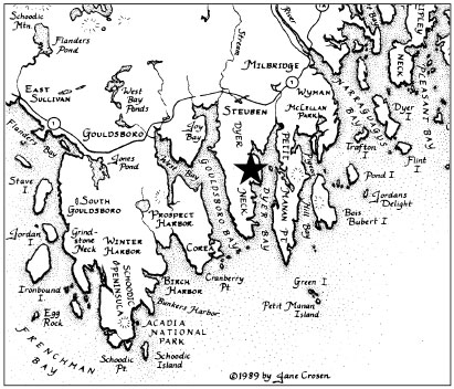
About Downeast Maine
Community Engagement
About Us
Donate Now
Contact Us
| A note about carpooling ... Please let us know if you might be interested in carpooling from the Bangor Airport or another location. Carpooling back to Bangor is almost always possible on Saturday morning. |
Travel to Eagle Hill by Car
For public transportation options ... Click here.
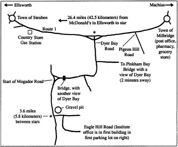
Eagle Hill is located in the town of Steuben on the coast of Maine about halfway between Ellsworth and Machias, approximately 50 miles from the Canadian border. With these directions, you should easily be able to find your way to Eagle Hill. Just in case, our phone number is 207-546-2824, Ext 4, or 718-715-2824.
From Inland (Augusta or Bangor)
From Augusta -Take Interstate 95 to Augusta and take exit 109 (Route 100) east. Turn right onto Route 3 and continue on it all the way to Belfast. From there, turn onto Route 1 north to Ellsworth. From there, follow the directions for “along the coast from the south” below.
From Bangor -Take Interstate 95 to Bangor. Take exit 182 onto Route 395. Follow 395 until it ends and exit onto Route 1A (Wilson Street) heading south towards Ellsworth. In Ellsworth, Route 1A continues straight as High Street where it joins with Route 1 and Route 3 at the corner with Main Street and the Washington Junction Road. Approximately 3/4 mile down High Street, take the left turn to stay on Route 1 heading north where it diverges from Route 3 (which continues straight toward Mount Desert Island). From that turn, follow the directions for “along the coast from the south” below.
Along the Coast from the West
Drive towards the city of Ellsworth. When leaving Ellsworth, drive north on Route 1 for just over 26 miles (42 km). After the town of Gouldsboro, you will pass the “Welcome to Washington County” billboard on the right. Drive past all signs for the town of Steuben on the right. You will then see the Steuben Fire Department/Town Hall building with its vast expanse of lawn on the left. Continue on Route 1 past Steuben Country Store/Sunoco gas station on the right. After this Sunoco, take the second right onto Dyer Bay Road (there is a street lamp at the intersection). Look for the big blue signs saying “Eagle Hill Institute/Airie Restaurant” just before the turn onto Dyer Bay Road – Eagle Hill is about 4 miles farther (see below). If you see the sign for Pigeon Hill Road on your right, you have gone too far.
Along the Coast from the East
Drive towards the city of Ellsworth heading south on Route 1. After passing through the town of Milbridge, drive past a large brown sign for Petit Manan National Wildlife Refuge and Pigeon Hill Road on the left. Look for the big blue signs on the right saying “Eagle Hill Institute/Christopher’s Restaurant” just before Dyer Bay Road. Take the next left turn onto Dyer Bay Road – Eagle Hill is about 4 miles farther (see below). If you see Steuben Country Store/Sunoco gas station on the left, you have gone too far.
From Route 1 and Dyer Bay Road to Eagle Hill – The last stretch
Continue on Dyer Bay Road until you come to a T-intersection after a small bridge. Here you will see the big blue signs saying “Eagle Hill Institute/Airie Restaurant” indicating you should turn left at this intersection onto what is now called Mogador Rd. At about 3.5 miles from Route 1, you will see a gravel pit on the left and then a wooden sign also on the left that says Eagle Hill Institute and Christopher’s Restaurant. Turn left here onto the dirt road called Schooner Point Road. After the first hill, turn right onto the dirt road called Eagle Hill Road. The large Commons Building and smaller office building will both be on your right and the first parking lot will be on your left. You can obtain a free trail map from either of these buildings.
Emergency phone numbers
In case of questions while traveling, call the office at 207-546-2821 Ext 4, or Joerg at 718-715-2824.