2010 V. Etting 151
Introduction
The 16th and 17th centuries constitute the great
epoch of European expansion, and the discovery of
new lands all over the world was accompanied by
eager ambitions for mercantile profi t and a race to
incorporate the new territories into the various European
kingdoms. The discovery of America opened
up a whole new continent, and after Magellan’s circumnavigation
of the Earth in 1519–1522, colonization
of the new lands started in earnest.
These hopeful prospects were certainly the background
for a renewed interest in the rediscovery of
Greenland, and various expeditions were organized
by the Danish Crown from the end of the 15th century
to the beginning of the 17th century. All contact with
the Nordic settlements on Greenland had little by little
been lost, and the old sailing routes were forgotten
(Fig.1). The last written evidence from Greenland
goes back to 1408 in connection with a marriage in
the church of Hvalsey, and after this, the sources are
silent. The dissolution of the Nordic settlements was
probably due to a combination of various factors: a
colder climate caused serious problems for agriculture,
the trade was declining, and the economic crisis
had a severe impact on the social structure. Together,
these circumstances caused a decrease in the number
of inhabitants, and the connections with the outside
world failed, whereas hostilities with the Eskimos
increased (Arneborg 2003). After 1378, no bishop
found it worthwhile to visit the bishopric of Gardar,
even though the empty title lived on. As a result of
all these factors, the Nordic community died out during
the 15th century.
The interest to revive the contact with Greenland
lived on, however, and the monarchs of the Danish-
Norwegian kingdom tried to organize expeditions in
order to rediscover this lost province of the kingdom.
Around 1472, King Christian I sent out the privateer
Hans Pothorst with the German Didrik Pining, but
the results of the expedition are unclear (Daa 1882).
A new attempt was made by King Christian II, probably
inspired by his chancellor Erik Valkendorf,
who had eagerly collected all kinds of information
and accounts about Greenland. In 1519, Pope Leo X
appointed a new bishop to Gardar in connection to
Christian II’s plans to conquer Greenland from the
hands of the pagans with a great fl eet (Dipl.Norv.
XVII, nr. 1184). Evidently these ambitious plans depended
on the rediscovery of Greenland and the King
appointed the rather disreputable nobleman Søren
Norby to organize the expedition, which thus could
be compared to a crusade (Møller Jensen 2004:132).
In February 1521, Søren Norby wrote to the King,
that he was working to make a ship ready, but had
problems getting a proper mast, so he couldn’t be
ready to sail for Greenland until after Easter (Aktstykker
1905: 309). In the end, however, all the plans
failed due to the outbreak of war with Sweden.
In spite of these fruitless attempts, the interest
in Greenland lived on, and imaginative sketches of
the country were included on maps like the famous
Carta Marina from 1539 (Fig. 2).
It was to be an Englishman, Martin Frobisher,
who finally rediscovered Greenland during his
expeditions of 1576–78, even though his primary
aim was to fi nd the elusive northwestern passage to
India. The land was baptised “Meta Incognita”, but
soon the English realised that it must be identical
with Greenland. After having read the account of the
expeditions, the Danish King Frederik II wrote a letter
to Queen Elizabeth of England to inform her that
he intended to employ Frobisher as part of his plans
to reunite Greenland with the Danish-Norwegian
kingdom. The King invited him to Copenhagen in
1582, but during his visit, Frobisher changed his
mind. A diffi cult political situation might arise if
both kingdoms claimed their right to Greenland, and
various considerations about these delicate questions
probably caused the plan to be dropped.
The Expeditions of King Christian IV
In the reign of the following King, Christian IV
(1588–1648), a new ambitious policy was launched,
and in England, the coronation of James I in 1603
marked the start of a new political strategy in the
The Rediscovery of Greenland during the Reign of Christian IV
Vivian Etting*
Abstract - The following paper describes the great expeditions to Greenland in 1605–1607 that sought to rediscover this
lost part of the Danish-Norwegian kingdom. Closely connected to these efforts was a later expedition in 1619 to fi nd the
assumed Northwest Passage north of America to India and China. This ambitious strategy was launched by King Christian
IV, who had a strong political and economical interest in the expeditions. However, he certainly displayed a genuine interest
in the unknown fate of the Nordic settlements as well.
Special Volume 2:151–160
Norse Greenland: Selected Papers from the Hvalsey Conference 2008
Journal of the North Atlantic
*National Museum of Denmark, Danish Middle Ages and Renaissance, Frederiksholms Kanal 12, 1220 København K.,
Denmark; vivian.etting@natmus.dk.
2010
152 Journal of the North Atlantic Special Volume 2
Figure 1. The oldest depiction of Greenland is part of the so called Clavus map (h. 43.5 cm; w. 39 cm). The Dane Claudius Clavus worked as a cartographer in northern Italy in the
1420s, and three maps of Scandinavia are known by him. This fi ne copy from 1466 is based on his second map, which includes Greenland. Clavus’ knowledge of Greenland was
probably based on contemporary accounts at a time when the connections with the Nordic settlements were still preserved. The map comes from an edition of Ptolemy’s World Atlas,
which is now in the collections of the Biblioteca Medicea in Florence, Italy. Photo courtesy of Biblioteca Nazionale Centrale di Firenze. (For a high resolution jpg fi le of this map
which you can zoom in on to view the details, see Supplementary fi le 1, available online at http://www.eaglehill.us/JONAonline/suppl-fi les/JS2-090220-Etting-s1, and, for
BioOne subscribers, at http://dx.doi.org/10.1656/JS2-090220.s1).
2010 V. Etting 153
North Atlantic. His marriage with a sister of Christian
IV had opened up far more friendly attitudes
towards Denmark, which soon became evident. The
rediscovery of Greenland and a presumed Northwest
Passage to China and India was certainly a matter of
the greatest interest. As early as 1599, the Danish
King had personally commanded a fl eet of 8 ships
on an expedition to the North Cape and the Kola
Peninsula, and he was certainly experienced in seamanship
and navigation (Fig. 3).
In May 1605, the fi rst of three expeditions sailed
off towards Greenland, and—despite great diffi culties
in the icy waters—succeeded in landing on the
west coast of Greenland (Fig. 4). The English admiral
John Cunningham was appointed as leader of the
expedition on the ship “Trost”, and the experienced
James Hall was navigator. The Danish nobleman
Godske Lindenow had command of the fl agship
“Ruber Leo” (The Red Lion), whereas the third ship,
called “Marekatten”, had an English captain named
John Knight. However, severe disagreements broke
out during the voyage, and The Red Lion separated
from the two other ships.
After the separation, Godske Lindenow and
his crew decided to go ashore near the district of
Fiskenæsset, where they bought furs and walrus-tusk
from the local Eskimos. They caught two men, who
were brought back to Copenhagen. In the meanwhile,
the two other ships sailed up north towards the
present Sisimiut (Holsteinsborg) and gathered some
stones in the vain hope that they proved to contain
silver ore. After having traded with the local inhabitants,
they caught four Eskimos, and the two ships
returned to Copenhagen. The Englishman James
Hall, who sailed with John Cunningham on the ship
“Trost”, wrote a report to the King about the voyage,
which included three small maps and drawings of
some landfalls (Fig. 5). A copy of this report is now at
the British Museum and was printed in 1897 (Gosch
1897, Kejlbo 1980, Kisbye Møller 1985).
This fi rst expedition was considered a great
success, and several reports and stories witness
the great excitement it aroused in Denmark. The
learned professor and later Bishop Hans Poulsen
Resen made a large map of Greenland, decorated
with small drawings of the native Greenlanders with
kayaks, dog sledges, bows, and arrows (Fig. 6). An
important account can be found in a manuscript
of 66 pages, written by the Norwegian nobleman
Jens Bielke (1580–1659) shortly after the return of
the expedition (Fig. 7). The text, in Danish verse,
is based on eye-witness accounts from that part of
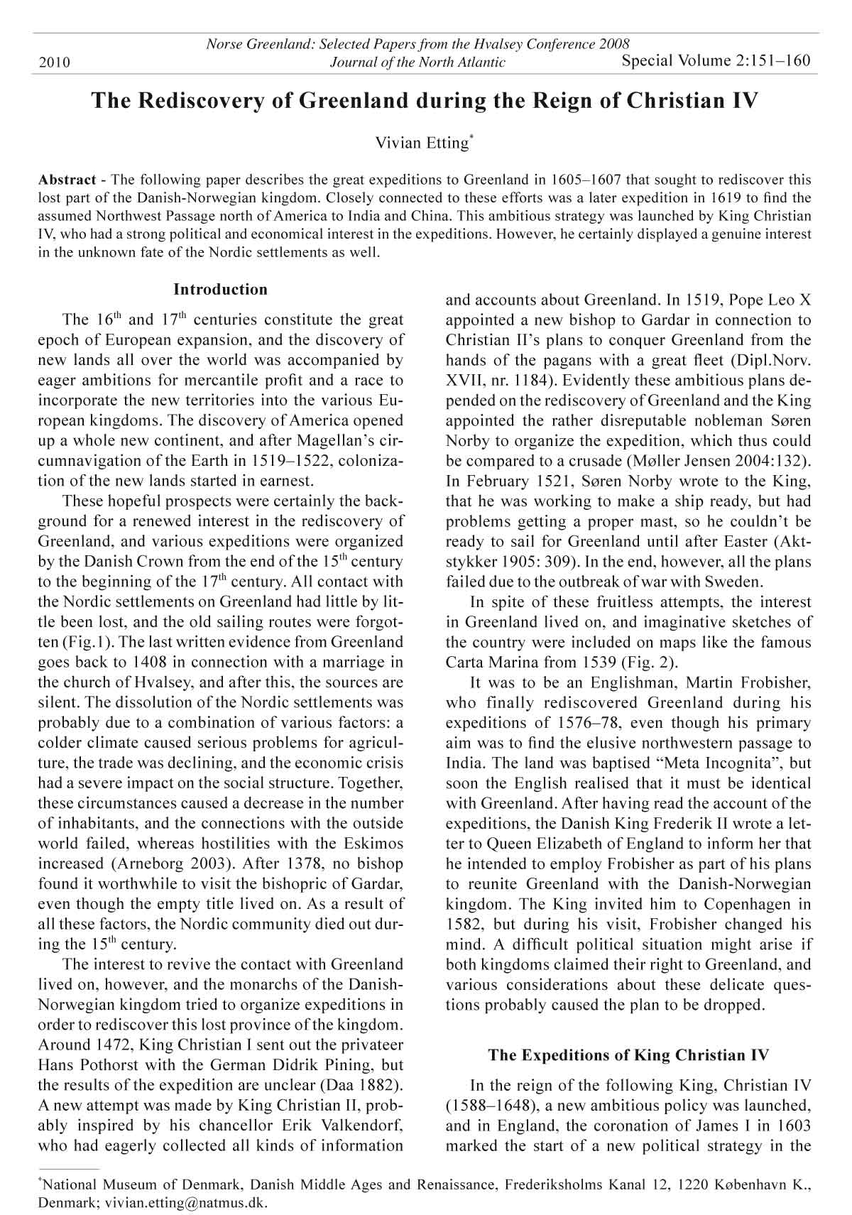
Figure 2. Carta Marina was published for the fi rst time in Venice 1539. It was made by the Swede Olaus Magnus, and later
printed as part of his book History of the Nordic People (Historia de gentibus septentrionalibus), Rome 1555. In a corner
of the map is depicted a tiny part of Greenland even though all contact with the land had ceased almost a century earlier.
154 Journal of the North Atlantic Special Volume 2
Figure 3. Portrait of King Christian IV, painted by an English
artist in 1606—the same year as the second expedition
sailed for Greenland. Christian IV reigned over Denmark/
Norway for 60 years, and even though his military campaigns
were rather unsuccessful, he had a profound impact
on the development of art and science. Photograph courtesy
of the Museum of National History at Frederiksborg
Castle.
Figure 4. Passport for Godske Lindenow and others, issued 18 April 1605. This passport in Latin, with the signature of
Christian IV himself, was issued to Godske Lindenow on the occasion of the departure of the fi rst expedition to Greenland.
Courtesy of the Danish State Archives. Photograph © Vivian Etting.
Figure 5. A map of King Christian’s Fiord and a landfall.
Drawings from James Hall’s report about the fi rst expedition
in 1605. Courtesy of the British Library, London
(Royal M.S. 17 A. XLVIII).
Figure 6 (opposite page). Hans Poulsen Resen’s map of
Greenland from 1605 was strongly inspired by a very imaginative
map from 1590, made by the Icelander Sigurður
Stefánsson. Resen dedicated the map to King Christian IV
and his chancellor C. Friis. Detail from a larger map (77 x
57 cm) in The Royal Library in Copenhagen.
2010 V. Etting 155
156 Journal of the North Atlantic Special Volume 2
the expedition carried out by “The Red Lion”. It
presents detailed descriptions of the Greenlander’s
mode of life, clothing, housing, and food. Bielke
describes their arrival in Copenhagen with great enthusiasm
and relates how the King and Queen went
onboard “The Red Lion” to see the Greenlanders.
Afterwards, a sailing boat race was arranged in the
harbor between the two Greenlanders in a kayak and
a boat with 16 Danish rowers. Jens Bielke was very
impressed by their performance, but did not mention
the winners of the race.
After the great success of the fi rst expedition,
the King decided to send out a new expedition the
following year. To cover the expenses, a general tax
was imposed, and in May 1606, fi ve ships sailed
for Greenland, now under the command of Godske
Lindenow, whereas John Cunningham and James
Hall were his subordinates. However, this expedition
turned out to be a disappointment. Many samples
of stones were collected and 5 Eskimos were
caught, but the stones did not contain valuable metals.
Nevertheless, a third expedition was organized
in 1607, this time with only two ships and 44 men.
King Christian IV’s comprehensive and detailed
instructions in Danish for the third expedition are
still known from a copy in the royal chancellery
(Bobé 1909:315–318). It is addressed to Captain
Carsten Richardsøn and James Hall, and contains
very illuminating evidence about Danish interests
in Greenland. Among the main purposes of the expedition,
the King mentions the revival of contact
with the Nordic settlements at “Eriksfi ord”. He had
studied “old documents, both Norwegian as well as
Icelandic”, and mentions several churches, monasteries,
farms, and various geographic locations by
name. He is convinced that the settlement is located
on the eastern coast of Greenland, which is an obvious
deduction from the name “Østerbygden”. Richardsøn
and Hall are ordered to fi nd the descendants
of this population, and the King “did not doubt, that
they either understand Icelandic or the old Norwegian
language.” Besides this genuine interest in
rediscovering the old settlements, the King orders
the captains to investigate the possibilities of establishing
profi table trade in articles such as martens,
ermine, white falcons, blubber from seal and whale,
walrus-tusk, salmon, and skin and fur from elk, lynx,
fox, and wolves.
Not surprisingly, the expedition found no traces
of the old settlements. The two ships had severe
problems in the icy waters, and returned back to
Copenhagen by July 25th. After this disappointing
result, the expeditions to Greenland were suspended
for a long period. Instead, the King concentrated on
the establishment of a trading colony in India, and a
small fl eet of fi ve ships were sent out in 1618.
In his book Den Grønlandske Chronica (The
Chronicle of Greenland) from 1608, the historian
Claus Christoffersen Lyschander (1558–1623) sums
up the knowledge about Greenland at that time and the
results of the three expeditions. This 232-page book is
divided in two parts, where the fi rst part is a chronological
survey of the history of Greenland from 770 up to
the end of the Middle Ages, based on “old Antiquities
and Documents”. The second part gives a thorough
account of all three expeditions to Greenland, and here
Lyschander is one of the main sources.
Even though the expeditions to Greenland were
suspended for a period, the efforts to discover the
hoped-for Northwest Passage to China continued. In
1619, King Christian IV sent out two ships under the
command of the Norwegian Jens Munk, who was an
experienced sailor and navigator after many years in
Portugal, Brazil, the Baltic, and the North Sea. The
two ships, Enhjørningen (The Unicorn) and Lamprenen,
left Copenhagen with a total crew of 64 men
on the 16th of May 1619, and Christian IV wrote in his
diary: “May the almighty God grant it luck.”
The course of events on the expedition is described
in great detail by Jens Munk in his book
Navigatio Septentrionalis, which allows us to follow
the tragic travel from day to day. After having
sailed to Greenland, they passed the Davis Strait
and reached Hudson Bay. During the following
months, they explored the coastline and inner bays,
but bad weather forced them to spend the winter
on land. The camp, which was called “Munk’s
Vinterhavn”, was established at the mouth of a
Figure 7. Jens Bielke’s account of the fi rst expedition river later called the Churchill River. The following
1605. Courtesy of The Royal Library in Copenhagen.
2010 V. Etting 157
managed to sail back on one of the ships to Norway.
There they arrived on 21st September 1620. Jens
Munk’s moving account of the travel was published
four years later and attracted considerable attention
months were terrible, and one by one nearly all the
men died of scurvy (skørbug) and other diseases.
Finally, only Jens Munk and two other men were
alive, but with an unbelievable heroic effort, they
Figure 8. Jens Munk’s Navigatio Septentrionalis was published in 1624, four years after the fatal expedition. It included a few
illustrations, among which are this small map (a) and a scene from the camp (b). Courtesy of The Royal Library in Copenhagen.
158 Journal of the North Atlantic Special Volume 2
pounds), pieces of cast iron, etc. He concluded: “I
never saw such a miserable place in all my life.”
In 1964, a Danish expedition sailed to Hudson
Bay in order to locate the place where Jens Munk
and his crew spent the winter of 1619. They succeeded,
but the place had been disturbed by later settlements.
They brought back a number of artifacts,
but only very few can be connected to the expedition
in 1619 (Hansen 1965).
(Fig. 8). Thus, it is mentioned in detail by the
Frenchman Jean de la Peyrere in his book Relation
du Groenland from 1647.
Almost 100 years after Jens Munk’s expedition,
some English ships under the command of
captain James Knight arrived on the same location
near the Churchill River. Here they found many
sad remains from the expedition, which the captain
described in his diary. Among these were many
graves and objects like two brass guns (each 12
Figure 9. a. Map of Greenland and Hudson Bay, 1625. Based on old accounts, the map tries to reconstruct the location of
the old Norse settlements and churches. Note the term “NOVA DANIA” for present Canada! The colored drawing measures
49 x 127 cm. Photo courtesy of The Royal Library in Copenhagen. b. This section of the map shows the Eastern Settlement
with farms and churches scattered around Eriksfjord and Einarsfjord. Intriguingly, a forest (silva) is indicated next
to the cathedral (domkirke). (For a high resolution jpg fi le of this map which you can zoom in on to view the details, see
Supplementary fi le 2, available online at http://www.eaglehill.us/JONAonline/jona-suppl-fi les/JS2-090220-Etting-s2,
and, for BioOne subscribers, at http://dx.doi.org/10.1656/JS2-090220.s2).
2010 V. Etting 159
The Map of Greenland from about 1625
I will conclude this paper by highlighting a fascinating
map of Greenland, which now is kept at
the Royal Library in Copenhagen (Fig. 9 a–b). It is
a colored drawing from about 1625 measuring 49 x
127 cm, which evidently is drawn after Jens Munk’s
expedition, since his camp is indicated on the map
as well as the term “Nova Dania”. To my knowledge,
it is the fi rst time that this most interesting map has
been presented for an international audience.
If we look at Greenland, the shape of the southern
coastline is certainly very imaginative, probably
in order to solve the problems of the location
of the old Norse settlements. The attempt to place
“Østerbygden” to the east clearly demonstrates the
Cartographers hopeless effort to harmonize the various
historic and geographical sources. Of particular
interest are the Nordic churches, which are marked
on the map scattered around Eriksfjord and Einarsfjord.
Their names and locations were only known
from medieval sources, but it is evident that these
documents had been studied carefully. On this matter,
the map has close connections with the King’s
instruction to the third expedition in 1606.
Expeditions to Greenland were not resumed
until after the death of King Christian IV in 1648,
since the kingdom was involved in protracted
wars. A trading company called “Grønlandske
Kompagni” had been founded in 1635, but the 25
ship-owners were primarily interested in whaling.
The King granted the privileges under the
condition that each year two Eskimoes should be
brought to Denmark and educated in “religion,
language, and academic studies”, but this noble
purpose was never fulfilled.
After the succession of Frederik III, new expeditions
were sent out. In 1652–54, three expeditions
to the east and the west coast were organized under
the command of the Dutch captain David Dannel.
Four Eskimos were caught during the expedition
in 1654 and brought to Bergen in Norway, where
an unknown artist made a large painting of them
wearing their original clothes (Fig. 10). A mermaid
with “fl owing hair and very beautiful” was observed
as well, but unfortunately the attempts to catch her
failed.
This short survey of the Danish expeditions to
Greenland around 1600 shows that the efforts to
rediscover the land were not only based on imperialistic
and mercantile interests. In the true spirit of
the Renaissance, there was in fact a genuine wish to
fi nd out what had become of the northern settlers and
their farms and churches.
Literature Cited
Arneborg, J. 2003. Norse Greenland: Refl ections on the
discussion of depopulation. Pp. 163–181, In H.J.
Barrett (Ed.). Contact, Continuity, and Collapse: The
Norse Colonisation of the North Atlantic. York Studies
in the Early Middle Ages, University of York, UK.
Bielke, J. 1605. Relation Om Grønland and Enn Lystig
Disceptaz. The Royal Library, Copenhagen, Denmark.
Bjørnbo, A.A. 1912. Cartographia Groenlandica. In Meddelelser
om Grønland, nr. 48. København, Denmark.
Bjørnbo, A.A., and C.S. Petersen 1909. Der Däne Claudius
Claussøn Swart. Der älteste Kartograph des Nordens,
der erste Ptolomäus-Epigon der Renaissance.
Eine Monographie. Innsbruch, Germany.
Bobé, L. (Ed.). 1909. Aktstykker til Oplysning om Grønlands
Besejling. 1521–1607. Pp. 303–324, In Danske
Magasin 5 rk. 6. Gyldendal, Copenhagen, Denmark.
Bobé, L. (Ed.). 1936. Diplomatarium Groenlandicum
1492–1814. Kommissionen for Videnskabelige Undersøgelser
i Grønland, København, Denmark.
Bugge, G.N. 1930. John Davies tre rejser til Grønland i
Aarene 1585–87. In Det Grønlandske Selskabs Skrifter
VII. Gads Forlag, Copenhagen, Denmark.
Daa, L. 1882. Didrik Pinning. Pp. 233–245, In Historisk
Tidsskrift. 2 rk. 3.
Etting, V. 1988. Geography and cartography in the time
of Christian IV. Pp. 404–409, In S. Heiberg (Ed.).
Christian IV and Europe. The 19th Art Exhibition of
the Council of Europe, Denmark 1988. P. Kristensen,
Herning, Denmark.
Figure 10. Painting of the four Eskimos, who were caught
during the expedition in 1654 and brought to Bergen
in Norway. Photo courtesy of The National Museum of
Denmark.
160 Journal of the North Atlantic Special Volume 2
Gad, F. 1967. Grønlands Historie. Vol. I: Indtil 1700.
Nyt Nordisk Forlag, Arnold Busck, København, Denmark.
Gosch, C.C.A. 1897. Danish Arctic Expeditions 1605–19.
Vol. I, P. XXXI, In The Hakluyt Society, vol. 96. Work
issued by the Harkluyt Society, London, UK.
Gulløv, H.C. (Ed.). 2004. Grønlands forhistorie. Gyldendal,
Copenhagen, Denmark.
Hansen, Th., and P. Seeberg. 1965. Jens Munks Minde-
Ekspedition. Gyldendal, Copenhagen, Denmark.
Kejlbo, I.R. 1980. Map material from King Christian the
Fourth’s expeditions to Greenland. Pp. 193–212, In
Wolfenbütteler Forschungen. Bremen, Germany.
Kisbye Møller, J. 1985. Jens Bielkes grønlandsberetning
1605. Pp. 117–148, In Tidsskriftet Grønland, nr. 5–7.
Ed. Det Grønlandske Selskab. Copenhagen, Denmark.
Kisbye Møller, J. (Ed.). 1987. Peder Hansen Resen:
Groenlandia, ca. 1653–54. Pp. 1–189, In Det Grønlandske
Selskabs Skrifter 1987, nr. 28. Copenhagen,
Denmark.
Knight, J. 1717 (1932). The Founding of Churchill. Being
the Journal of Captain James Knight. James F. Kenney
(Ed.). Toronto, ON, Canada.
Krogh, K. 1967. Viking Greenland. The National Museum
of Denmark, Copenhagen, Denmark.
Lange, C.A.A. (Ed.). 1849–1901. Diplomatarium Norvegicum.
Vol. I–XIX. Kristiania, Oslo, Norway.
Lauridsen, P. 1883. Jens Munks Navigatio Septentrionalis.
Med indledning, Noter og Kort. København,
Denmark.
Lyschander, C.C. 1608. Den Grønlandske Chronica.
Manuscript in 232 pages at The Royal Library, Copenhagen,
Denmark.
Møller Jensen, J. 2004. Den glemte periferi og de glemte
korstog. Grønland og korstogene 1400–1536. Pp.
108–145, In Historie, 2004, vol.1. Jysk Selskab for
Historie, Aarhus, Denmark.
Munk, J. 1624. Navigatio Septentrionalis. Copenhagen,
Denmark.
Seaver, K.A. 1996. The Frozen Echo: Greenland and the
Exploration of North America, ca. A.D. 1000–1500.
Stanford University, Palo Alto, CA. 407 pp.
Seaver, K.A. 2004. Maps, Myths, and Men: The Story of
the Vinland Map. Stanford University, Palo Alto, CA.
480 pp.
Svensson, S. 1960. Kristian den Andres planer på en Arktisk
expedition och deras förutsättningar. Ett bidrag
till de geografi ske upptäckternas ideologi. In Lunds
Universitets Årsskrift, Ny. rk. I, 54/5. Lund, Sweden.