2010 B. Gjerland and C. Keller 161
Introduction
The literature of the medieval Icelanders gives a
unique insight into the history, culture, and religion
of the North Atlantic Norse. It conveys the medieval
Icelanders’ perception of themselves and their past.
For good and bad, it is the insiders’ view (Hreinsson
1997, Kristjánsson 1988, Ólason 1998).
Archaeology does not have the same explanatory
power as the written word when it comes to exploring
the mentality of people in the past. However, despite
its shortcomings, archaeology may still convey
valuable information about the mindset of the Viking
and medieval Norse. Can the Norse peoples’ use of
the landscape tell us something about their values
and beliefs?
Was there really a common religious Norse
geography in pagan times, and did it continue into
the early Christian era? Or, were there differences
in the organization of the religious elements in
the landscape between West Norway, Iceland, and
Norse Greenland? Although the issues are familiar,
these exact questions have not been addressed
through landscape archaeology, and no obvious
methods for comparisons of landscapes of this kind
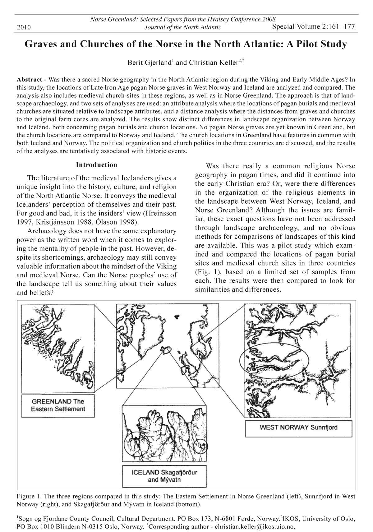
are available. This was a pilot study which examined
and compared the locations of pagan burial
sites and medieval church sites in three countries
(Fig. 1), based on a limited set of samples from
each. The results were then compared to look for
similarities and differences.
Graves and Churches of the Norse in the North Atlantic: A Pilot Study
Berit Gjerland1 and Christian Keller2,*
Abstract - Was there a sacred Norse geography in the North Atlantic region during the Viking and Early Middle Ages? In
this study, the locations of Late Iron Age pagan Norse graves in West Norway and Iceland are analyzed and compared. The
analysis also includes medieval church-sites in these regions, as well as in Norse Greenland. The approach is that of landscape
archaeology, and two sets of analyses are used: an attribute analysis where the locations of pagan burials and medieval
churches are situated relative to landscape attributes, and a distance analysis where the distances from graves and churches
to the original farm cores are analyzed. The results show distinct differences in landscape organization between Norway
and Iceland, both concerning pagan burials and church locations. No pagan Norse graves are yet known in Greenland, but
the church locations are compared to Norway and Iceland. The church locations in Greenland have features in common with
both Iceland and Norway. The political organization and church politics in the three countries are discussed, and the results
of the analyses are tentatively associated with historic events.
Special Volume 2:161–177
Norse Greenland: Selected Papers from the Hvalsey Conference 2008
Journal of the North Atlantic
1Sogn og Fjordane County Council, Cultural Department. PO Box 173, N-6801 Førde, Norway.2IKOS, University of Oslo,
PO Box 1010 Blindern N-0315 Oslo, Norway. *Corresponding author - christian.keller@ikos.uio.no.
2010
Figure 1. The three regions compared in this study: The Eastern Settlement in Norse Greenland (left), Sunnfjord in West
Norway (right), and Skagafjörður and Mývatn in Iceland (bottom).
162 Journal of the North Atlantic Special Volume 2
The primary goal was to find methods for
comparing landscape locations between the three
countries. The second goal is to identify significant
differences in the organization of religious elements
in the landscape, and to discuss and possibly explain
them in relation to the religious and political development
of the three countries.
The farm was the hub around which the social,
economic, and spiritual life in the Norse world revolved.
In search of Norse cultic landscapes, pagan
or Christian, it is natural to focus on the location of
the farms, farm cores, pagan graves, and churches.
The sites in the three countries were selected
from the Sunnfjord region in Sogn og Fjordane in
West Norway, the Mývatn and Skagafjörður regions
in Northern Iceland, and the so-called Eastern
Settlement and Western Settlement in South West
Greenland (Fig. 1). All the sites in West Norway
and Iceland were visited in the field. Most of the
Greenland sites have been visited earlier; all were
analyzed on the basis of published archaeological
maps (in Krogh 1982 and in Guldager et al. 2002).
Two methods were used to make the comparisons:
an attribute analysis where the sites (graves and
churches) were classified according to their proximity
to certain landscape variables or attributes, and
a distance analysis where the distances between the
sites and the farm cores were measured.
The analysis shows that in West Norway there
was continuity in the use of the landscape from pagan
to Christian times. In Iceland, the pagan burials
are located according to different principles than
the burials in West Norway, and there appears to be
a break in continuity from pagan to Christian times.
No pagan burials have yet been found in Greenland.
The early churches in Iceland lie completely integrated
among the farm houses (see Krogh 1983).
This pattern seems to be the case also for some of
the West Norwegian churches. Other Norwegian
churches, however, are located in what appears to be
more publicly accessible areas away from the farm
houses. These church sites differ dramatically from
the Icelandic church sites, and are believed to reflect
a new principle for church building in the Norwegian
Middle Ages.
Greenland’s church locations appear to be a combination
of the Icelandic and the Norwegian location
types, showing affinity both to Icelandic and Norwegian
church-building traditions.
Visual Landscape Analysis
The field-work behind this study was initially
based on the principles of visual landscape archaeological
methods as they were presented in 1997
(Gansum et al 1997). The methods launched back
then were modifications of a landscape architectural
approach (as in Lynch 1992), but adapted to serve as
landscape archaeological tools.
The principle of a visual landscape analysis is to
describe how the various elements in the landscape
are located relative to each other (what may be seen
from where, which sites are visually dominant, and
which seem more isolated or remote). In an archaeological
context, it is also important to know what
constructions were contemporary and what function
they had, as well as the relative age of the various
installations in the landscape.
For this paper, only a selection of the data collected
during the field-work was used. This paper
focuses on spatial organization and layout, and especially
the proximity between various features in
the landscape, and also how various topographical
elements have been used.
Farms
The Norse population lived at farms. Farms are
places, and most events recorded in the medieval
written records are associated with specific farms.
The farm core1, i.e., the cluster of houses in each
farm unit, was the principal social arena in Norse society.
In the present analysis, the ancient farm cores
have been tentatively reconstructed using archaeological
and/or retrospective historical methods.
The historic farm cores sometimes had almost
village-like properties; often they also consisted of
several holdings2. The West-Norwegian “klyngetun”
(clustered farm / historical farm) was perhaps
the closest to a village in appearance (e.g., Berg
1968:87–210). Here, sites of the historical farm core
are supposed to go back to at least the Middle Ages,
perhaps even further. Archaeologically, farm cores
from the Early Iron Age have frequently been discovered
on present-day farm lands. Farm cores from
the Late Iron Age are, on the other hand, rarely found
and therefore are assumed to lie in the same place as
the historical farm core. Recent archaeological investigations
in West Norway have also confirmed this
interpretation, both directly and indirectly. In fact the
investigated farm cores go back to at least Pre-Roman
times (Dokset 2007, Olsen 2010, Øye 2002:69).
Towards the end of the nineteenth century, a
land reform was launched in Norway to assemble
the many small lots of land into larger, more viable
units, and new, single-farm cores where built.
Detailed farm maps describing the situation before
the land-reform and specifying the location of the
old farm lots, farm cores, boundaries, home fields,
roads, and landing places were used as important
source material for this analysis.
Viking Period burials in Trøndelag3 may be associated
with prehistoric farms (Sognnes 1988:15),
but not all the prehistoric farms have archaeologi2010
B. Gjerland and C. Keller 163
cally visible graves. In other regions, the farm-grave
relationships are not that simple; many farms have
more than one Iron Age cemetery, and others have
none. Studies indicate that Late Iron Age graves
may represent independent (i.e., inheritable) farms
(Iversen 2004:66–71). A farm without graves may,
on the other hand, indicate a tenant farm. It should
be remembered that most people in the pre-Christian
era did not get an archaeologically visible burial.
In the attribute analysis in Table 1 and Figure
2, the reconstructions of farm cores contemporary
with the Viking Age graves in West Norway were
based on the land-reform maps from the end of the
nineteenth century. In Iceland and Greenland, the
contemporary farm cores were identified archaeologically.
The home fields were identified either
on the basis of land-reform maps (Norway), or on
home-field boundary walls (Iceland), or on the improved
fields next to the farm cores (Greenland).
Pagan Burials
Burial customs in Viking Scandinavia were extremely
diverse (Gräslund and Müller-Wille 1993).
In Norway alone, some 6000 graves from the Viking
Period are known (Solberg 2000:222), some with
horses and boats (Müller-Wille 1970). Both cremation
and inhumation burials were used in Scandinavia,
but cremations decline towards the south and
west; they are less common in Denmark, rare in
the Norse cemeteries in the British Isles, and nonexistent
in Iceland (Graham-Campbell and Batey
1998:144; but see Friðriksson in Eldjárn 2000:594,
Richards 2003:391).
Graves in Norway are normally marked by a
mound or cairn, usually in an easily visible spot—
located near the farm core or within sight of it, by
the farm road, or sometimes by the boat-house or
-landing (Solberg 2000:222). There are also Viking
Period graves under flat ground, often with a modest
Figure 2. Radar diagram showing landscape attributes connected to burial sites in West Norway and Iceland. For comparison,
burials from West Norway dated to Early Iron Age and the General Iron Age are indicated. Eight attributes are indicated
clockwise around the diagram; they are not mutually exclusive, i.e., one burial site may feature one attribute, another two
or three attributes.
Table 1. Landscape attributes connected to burial sites in West Norway and Iceland. For comparison, burials from West
Norway dated to Early Iron Age and the General Iron Age are included.
Attributes
Area Farm core Home field Route Post-box Boundary Water Beach Welcome
Raw data
Early + General Iron Age in West Norway 8 11 8 3 1 10 8 5
Late Iron Age in West Norway 8 8 0 1 0 5 5 7
Iceland 0 0 8 3 6 7 7 7
Normalized data
Early + General Iron Age in West Norway 14.8 20.4 14.8 5.6 1.9 18.5 14.8 9.3
Late Iron Age in West Norway 23.5 23.5 0.0 2.9 0.0 14.7 14.7 20.6
Iceland 0.0 0.0 21.1 7.9 15.8 18.4 18.4 18.4
164 Journal of the North Atlantic Special Volume 2
stone paving.
In terms of the grave furniture, the roughly 350
graves discovered in Iceland may be associated with
the lower to medium range of Norwegian graves in
terms of status. The burials in Iceland are often located
by a track, but often also near a boundary, or facing
a lake, river, or the sea. Most of them lie under flat
ground with little or no preserved surface marking;
many have horses and some have boats (Friðriksson
in Eldjárn 2000:592–593, 610; Friðriksson 2004).
They are notoriously difficult to find.
The Icelandic graves may have much in common
with the North Norwegian graves from the
Merovingian period (560/570–800 A.D.; see Solberg
2000:182–184, 186–188). These are usually inhumation
graves and often under flat ground, and the
frequency of horses in the burials increases into the
Viking Period.
Norse Greenland was, according to the written
records, settled around A.D. 985. The Saga of Eirik
the Red (Eiríks saga rauða) claims Eiríkr was a pagan
on arrival in Greenland, and credits his son Leifr
with the introduction of Christianity. The credibility
of the story has been questioned (e.g., Krogh 1975).
No unequivocal pagan Norse burials have yet been
found in Greenland, but considering how difficult
it is to find pagan graves in Iceland, the question of
pagan burials in Greenland must remain open.
The burial customs of the Norse changed dramatically
with the introduction of Christianity in the
tenth to eleventh centuries; all Christians were entitled
to burial in consecrated ground. In Scandinavia,
Iceland, and Greenland, the dead were inhumed
in cemeteries which, like in the British Isles, were
established around the churches. Most medieval
churches in the Northern world were built at farms,
and most of the churches and their parishes still carry
their original farm names (Olsen 1928:234–255).
Pagan Burials: Attribute Analysis
Ten burial sites in Sunnfjord4 in West Norway
were selected for comparison with burial sites in
Iceland. Previous analyses of these and other sites
in the Sunnfjord region were performed by Gjerland
in Sigurðsson et al. 2005. The burials were dated to:
1. Early Iron Age (ca. 500 B.C.–A.D. 560/570), 2.
Late Iron Age (A.D. 560/570–1050), and 3. Iron Age
General (500 B.C.–A.D. 1050; these are burials that
belong to either the Early or Late Iron Age, but either
the artifacts did not allow a more specific dating, or
the cairns have not been archaeologically examined).
The attributes selected are (clockwise from top
of Fig. 2): Farm core = location among or nearby the
houses on a farm; Home field = location at the home
field;Route = location at or addressing a major route
or track, i.e., between farms or settlements; Post-box
= location at or addressing the track from a major
road to the farm core; Boundary = location at or addressing
a farm boundary on land; Water = location
overlooking or addressing either the sea, a lake, or a
river; Beach = location at a beach (will often address
water); and Welcome = location at or addressing the
track leading from a boat-landing5 to the farm core.
For comparison between West Norway and
Iceland, only graves from the Late Iron Age are
relevant, but in order to discuss continuity within
West Norway, graves from the earlier periods were
included in the analysis.
The burials are single, or in small grave fields.
Most of the graves do not exist in the landscape
today, but the material and locations are recorded in
the archaeological archives.
From Iceland, burial sites from ten farms in the
Skagafjörður and Mývatn regions were selected for
visual analysis. Site locations and archive information
were kindly provided by Guðný Zoëga, Adolf
Friðriksson, and Árni Einarsson.
The number of analyzed localities is modest, and
the results should therefore be treated with caution.
Based on our general archaeological knowledge,
however, it is likely that the attributes will prove to
be significant also in larger regional studies.
The actual material information is presented as
raw data and is given in the tables. The presentation
in the radar diagrams show normalized data and thus
give a relative value of the different attributes compared
to each other within each area. The normalized
data must, however, be used with caution due to the
limited number of analyzed objects.
The West Norwegian graves in this material are
located close to the farm cores, and they are also on
the home fields. This relationship seems consistent
throughout the Iron Age. This aspect of the West
Norwegian graves marks a distinct disparity with
the Icelandic graves in this material, which never
lie close to farm cores or on the home-fields (the
distance between farm cores and graves is addressed
in the section on distance analysis below). In contrast
to the West Norwegian graves, all the Icelandic
graves in the material are situated near routes, and
most of them are also near farm boundaries. This
situation is rare in the West Norwegian Iron Age material,
and almost non-existent in the Late Iron Age.
There are two sets of attributes that appear to
complement each other, which should be discussed
together. The first set consists of graves on a beach,
and/or overlooking water, and/or in a welcoming
position, i.e., on the track between the boat-landing
and the farm core. In West Norway, these locations
are common both for Late Iron Age graves and for
Iron Age graves in general. The attributes all have
to do with water in some form or other. It is tempting
to suggest that they indicate travel by boat or on
ice. The second set consists of graves overlooking
a route, and in post-box positions, i.e., on the track
leading from a main route to the farm core. This
situation is typical for Iceland, but these locations
2010 B. Gjerland and C. Keller 165
are rare in the West Norwegian material. These attributes
also have to do with travel, only this time on
land, i.e., on foot or on horse-back.
Travel on fjords and on lakes is traditional in
West Norway, while travel on foot or on horseback
is traditional in Iceland. Still, quite a few burial sites
have a marine orientation. It is possible that the two
groups of attributes represent similar connotations,
only adapted to the local conditions for travel.
Pagan Burials: Distance Analysis
It was pointed out that the Iron Age burials in
West Norway were situated closer to the farm cores
than the Icelandic burials in this analysis. The West
Norwegian graves have an affinity to farm cores and
home fields, while the Icelandic graves have an affinity to farm boundaries and routes some distance
away from the farm cores.
For a proper comparison, the distances between
graves and farm cores need to be specified (Table 2,
Fig. 3). This study shows that the West Norwegian
graves range from 70 to 700 m from the farm cores,
but the main body of the material lies within a medium
range of 100 to 300 m.
By comparison, the Icelandic burial sites range
from 300 to an impressive 1750 m, with the main
body of the material in the range of 500 to 1200 m
from the farm cores. Based on general knowledge of
Icelandic burials, these examples may tilt towards
the extreme, but distances in the vicinity of 500 m
seem to be quite common (see Maher 2009 for extensive
studies of graves and locations in Iceland).
The general observation that there is a difference
in the location of the pagan burials between West
Norway and Iceland seems to be largely confirmed
by the distance analysis, although caution must be
urged due to the limited sample size.
Pagan Burials: Discussion
The differences between the West Norwegian
and the Icelandic burial locations may be addressed
in several ways. To what extent did the
landscape of the dead resemble the landscape of
the living? The attribute analysis suggests that
in West Norway, burials from both the Early and
Late Iron Age often were located near the farm
core, i.e., close to where people lived, and close
to the social arena. It is equally significant that the
graves were situated at or in the direct vicinity of
the home field.
The farming economy of West Norway was a
mixed economy; cereal cultivation was combined
Figure 3. Distance between burial sites and farm cores in samples from Iceland and West Norway.
Table 2. Distance between burial sites and farm cores in samples from Iceland and West Norway.
Area Distance (m)
West Norway 70 75 100 140 140 230 280 340 350 400 400 500 750 800
Iceland 300 500 500 500 500 1100 1240 1400 1750
166 Journal of the North Atlantic Special Volume 2
Icelandic culture for centuries (Adolf Friðriksson in
Eldjárn 2000:610).
Graham-Campbell and Batey (1998:145) observed
that in Scandinavian Scotland the dead
were often “… removed some distance from the
living for burial …”, i.e., similar to the pattern in
Iceland. They also noted (1998:145–156) that there
was “a marked tendency in Scandinavian Scotland
to utilize pre-existing mounds, thus ensuring the
identification of the burial place in the landscape.”
Using other peoples’ cemeteries may be a way of
demonstrating power, but it may also be pure convenience
(see Barrett 2003, Geake 2003, Meaney
2003, Richards 2003 for overview of Norse burial
customs in Britain. Ambrosiani 1998 for Ireland,
Andersson 2005 and Welinder 2003 for Sweden). In
addition, there were Norse graves facing the sea, or
lakes, which apparently is quite common in the rest
of the Norse Atlantic area (Graham-Campbell and
Batey 1998:145).
The Christianization of Norway and Iceland
Scandinavians visiting the Continent or the British
Isles prior to the Viking Age would have encountered
Christians and Christianity in many forms and
places. The most likely contact areas were Germany6,
Anglo-Saxon England7, Ireland, and Frisia8 (Sawyer,
B. 1987; Sawyer, P.1987; Sawyer et al. 1987).
The thirteenth-century Icelandic chronicler Snorri
Sturlusson (Sturlusson et al. 1987) described the
Christianization of Norway. Playing down the German
influence as illustrated by Rimbert (Robinson
1921) and Adam of Bremen (Bremensis et al. 2002),
he called attention to the Christianization efforts of
Norway’s three missionary kings: Hákon Haraldsson
“the good”9 (A.D. 933–959), Óláfr Tryggvason
(A.D. 994–999), and Óláfr Haraldsson “the saint”
(A.D. 1015–1028).
Norwegian historians have traditionally embraced
the Anglo-Saxon Church as “the mother of
the Norwegian Church”10, in line with Sturlusson’s
description (Keyser 1856–58; Maurer 1855–56,
1895; and especially Taranger 1890; see Myking
2001 for historiography; also Bang 1887, 1912;
Birkeli 1982; Brendalsmo 2001; Bull 1912; Helle
1995a, b; Jackson 1994; Koht 1921; Kolsrud 1958;
Kragh 1995; Lönroth 1963; Løwe 1995; Sigurðsson
2003a:29; Sveaas Andersen 1995).
The charismatic kingships that appeared during
the Viking Period developed to a medieval statelike
structure under King Hákon Hákonarson (A.D.
1217–1263). The Gregorian Church Reform11 was
launched in Europe in the eleventh century to disengage
the Church from the power of secular leaders.
Prior to the reform, most churches in Northern
Europe were privately built and owned, either by the
community, the nobility, or the kings. This was also
the situation in Scandinavia.
with animal husbandry and supplemented with
hunting and fishing. Most indigenous religions
in farming communities somehow involve ancestors,
fertility, and productivity (Dumézil 1977;
Steinsland 2005:77–81, 144–164). It makes sense,
therefore, that so many of the West Norwegian
graves are located on or are addressing arable land.
It is tempting to interpret this close-to-home location
as related to ancestral worship (see Steinsland
2005:327–357).
Still, it is interesting that many of the graves
in West Norway and Iceland seem to relate to the
topic of travel, either because the burial location is
facing the sea, or because the dead was buried in a
boat (Müller-Wille 1970, Solberg 2000:263, Westerdahl
1991). Adolf Friðriksson wrote (in Eldjárn
2000:591–592) that graves in Iceland were usually
associated with a farm, but he continued: “In contrast
to the Christian graveyards, pagan burials were
not situated by the farmhouses or even within the
boundaries of the home field, but on the nearest suitable
ground outside the hayfields; on a low rise or
bank, perhaps half a kilometer or so away from the
farmhouse.” He has also stated that in some cases
graves were located near the boundaries between
properties, and in other cases beside a road or a track
(loc. cit. and Friðriksson 2004).
Torun Zachrisson speaks of rune-stones marking
boundaries in eleventh-century Sweden (Zachrisson
1998:194–196), and refers to the Irish practice of
burials with ogam inscriptions marking boundaries
(in Charles-Edwards 1976:85). The attribute analysis
in Figure 2 supports such relationships. In addition,
the comparison with West Norway points to the fact
that there is an almost negative correlation between
Icelandic burials, and farm cores and home fields.
The colonization or “landnám” situation in Iceland
may have required a different burial practice
simply for legal reasons. When the first settlers
arrived in Iceland around A.D. 874, there were no
ancestors buried on the land, and hence no graves to
worship. The Italian archaeologist Elena Garcea has
stated (in a completely different context) that “by infusing
the land with the remains of your people, you
claim it” (quoted in Gwin 2008:137). It is possible
that the graves of the early settlers in Iceland might
have served as territorial claims.
It is interesting that the graves both in Iceland
and West Norway have an affinity to the subject of
travel, either routes on land or water. This commonality
may indicate a connection between Scandinavian
and Icelandic burial customs, but Scandinavia
is not the only possible source of influence; at the
time of the colonization of Iceland, around A.D. 874,
there were several Norse kingdoms in the British
Isles (see Forte et al. 2005 for details). These Anglo-
Saxon-Norse hybrid societies clearly influenced
2010 B. Gjerland and C. Keller 167
copal seat was established at Garðar in the Eastern
Settlement (Keller 1991; Seaver 1996:33, 64–65).
Church Building
The contrasts between Norwegian and Icelandic
medieval churches were striking. The oldest Norwegian
churches were corner-post constructions in
wood with standing “staves” (vertical timbers) dug
into the ground. Post-holes from more than 30 such
churches have been excavated under the floors of
standing churches.
Norway is famous for its stave-churches, which
probably numbered some 750 by the end of the Middle
Ages; today only about 60 remain. Their construction
resembles that of the corner-post churches,
but the vertical timbers all rest upon a frame of
wooden sills laid out on the ground. So in contrast
to the stone churches and the turf churches, stave
churches leave no post-holes in the ground. Hence
these church sites are difficult to identify archaeologically.
(Christie 1981, 1983; KLNM Vol. 17:95–
107 “Stavkirke” [compare to KLNM Vol. 17:84–95
“Stavbygning”]—available online at http://www.
stavkirke.org and http://www.stavechurch.org, respectively).
The ca. 150 Norwegian stone churches that are
still standing were built after ca A.D. 1100, most
of them probably by foreign masons, and few if
any stone churches were built after the Black Death
A.D. 1349 (Ekroll 1997, Ekroll et al. 2000, Lidén
1991; see also Lidén 2008 [http://kunsthistorie.com/
wiki/index.php/portal:steinkirke]). It is virtually unknown
that North Norway also had a number of turf
churches. None are standing today, and very little is
known about these churches, their construction, and
dating (Bratrein 1968).
In Iceland, there are written records about ca.
320 parish churches in the Middle Ages. In addition,
there were numerous small churches that did not employ
a priest (Vésteinsson 2000:93, 295–296). Many
of these retained burial rights up towards the High
Middle Ages.
There are no standing churches from the Middle
Ages in Iceland, but both wood- and turf-churches
are known from the written records, and several turf
churches have been excavated (KLNM Vol. 17:101–
104, Vol. 7:121–122; Kristjánsdóttir 2004:45–50,
119–149; Vésteinsson 2000:93–143). The Icelandic
turf churches were basically timber buildings (both
corner-post and stave-constructions have been excavated)
with outer protective walls of turf and stone.
The gable ends were made of wood, or at least the
western gable which held the entrance. Turf houses
require high maintenance and are not long-lasting.
Contrary to Norway and Greenland, there are no
medieval stone churches in Iceland.
With the establishment of a Norwegian Church
Province in Niðarós (present-day Trondheim) in
A.D 1152–53, a true North Atlantic archbishopric
was set up12 (Imsen 2003). The foundation document
Canones Nidarosiensis established that the Gregorian
Reform be implemented in the new church province
(Bagge 2003:55–61, 80). With this reform, the
proprietary church system in Norway was brought to
an end, and private churches were transferred to the
Church. This transfer included the many churches
that belonged to the King. The intention was to apply
the Gregorian Reform throughout the Niðarós
Province, but after King Sverrir’s (A.D. 1177–1202)
fall-out with the Church during the Norwegian Civil
Wars, the reform was impeded. It was never implemented
to the full in Iceland and Greenland.
There were Christians among the early immigrants
to Iceland, and missionaries also came from
abroad. Iceland was ruled by chieftains who met
at the National Assembly “Alþingi” and ruled by
a common law. There was no central authority; the
political power rested with the chieftains.
During pagan times, the goðar were cult leaders
(Lucas and McGovern 2007; see also Lucas 2009).
When the question of Conversion to Christianity
was put before the National Assembly ca A.D. 1000
(Aðalsteinsson 1971, Kristjánsdóttir 2004:142–152,
Vésteinsson 2000:17–37), the goðar changed their
religion, but maintained their influence on religious
affairs. They resented intervention from the central
clerical authorities, and the tension probably increased
when Iceland and Greenland became parts
of the Niðarós Church Province A.D. 1152–53.
Bishops appointed by the Icelanders themselves sat
in office until 1237, but the right to appoint bishops
rested with the chapter in Niðarós from A.D. 1238
until the reformation 1536.
Throughout Iceland, churches had been erected
on private farms. As elsewhere, farmers donated
property to the churches, and gradually two types
of churches emerged: the “staðir” churches had full
ownership of the farm at which they were located,
and were financially attractive. The rest were called
bændakirkjur (peasant churches). The struggle between
the Church and the goðar in the twelfth and
thirteenth centuries to control the “staðir-churches”
is known as “staðamál” (Sigurðsson 2003b:122–124,
Stefánsson 1995, Vésteinsson 2000:90–91).
When Iceland and Greenland became parts of the
Norwegian kingdom from A.D. 1262–64, the time
of chiefly rule was brought to an end. However, as
mentioned above, the Gregorian reform was never
properly implemented in Iceland. Hence the proprietary
church system prevailed until the reformation.
Greenland was allegedly pagan for the first few
years, but converted to Christianity around the same
time as the Icelanders. Their first bishop, Arnald,
was consecrated in Lund A.D. 1124, and the Epis168
Journal of the North Atlantic Special Volume 2
Greenland’s churches appear to be a mixture
of Icelandic and Norwegian (or at least European)
traditions. Unlike Iceland, Greenland had several
European-style stone churches, particularly
the near-intact Hvalsey Church in Qaqortukulooq
built shortly after A.D. 1300 (Krogh 1982), which
has been suggested to be very similar to Norwegian
churches (Roussell 1941). The smaller churches,
including the so-called Þjóðhild’s church at Brattahlið/
Qassiarsuk (Krogh 1982:27–52, Krogh 1983)
appear to be in the same tradition as the Icelandic
turf churches.
Churches: Attribute Analysis
A traveler to the Norwegian countryside will
notice the white churches perched majestically on
top of hills overlooking the farms below or standing
proudly on the beaches along the west coast supervising
the traffic on the fjords. Going to Iceland,
the same traveler will be surprised to find rural
churches nested neatly among the farm houses, not
at all in such ostentatious locations as the Norwegian
churches. Why this difference in church location
between Norway and Iceland? Does it mean
anything? The visual impact is striking, but can
the difference be documented, and how? To have
a closer look at how the churches are actually located,
it is natural to start with an attribute analysis
similar to the one made for the burials (Table 3,
Fig. 4). To facilitate comparisons, the same eight
attributes that were used in the burial analysis are
utilized once more.
In West Norway, 15 medieval church-sites in the
Sunnfjord region were selected and visited for analysis—
the same region and some of the same farms that
Table 3. Landscape attributes connected to medieval church sites in West Norway, Iceland, and the Eastern Setlement and the
Western Settlement in Norse Greenland.
Attributes
Area Farm core Home field Route Post-box Boundary Water Beach Welcome
Raw data
West Norway 5 12 12 0 2 13 8 1
Iceland 10 10 5 4 0 2 0 0
Greenland 13 13 5 3 0 12 6 7
Normalized data
West Norway 9.4 22.6 22.6 0.0 3.8 24.5 15.1 1.9
Iceland 32.3 32.3 16.1 12.9 0.0 6.5 0.0 0.0
Greenland 22.0 22.0 8.5 5.1 0.0 20.3 10.2 11.9
Figure 4. Radar diagram showing landscape attributes connected to medieval church sites in West Norway, Iceland, and the
Eastern Settlement and the Western Settlement in Norse Greenland. Eight attributes are indicated around the diagram. They
are not mutually exclusive, i.e., one church site may feature one attribute, another two or three attributes.
2010 B. Gjerland and C. Keller 169
The church locations in these samples are strikingly
different. The West Norwegian churches in
the sample have an almost bimodal distribution, or a
slanted figure of eight, in the graph (Fig. 4). Up and
to the right are the attributes farm core, home field,
and route. The churches with these attributes belong
to what is called “Phase 1”, which will receive special
attention in the discussion below. Down and to the left
is another group of church sites that belongs to what is
called “Phase 2”, which also is discussed below.
The Icelandic churches in the sample have an
overwhelming affinity to farm core and home field,
similar to the Norwegian “Phase 1” churches. There
is also some affinity to route and post-box locations.
The Greenlandic churches in the sample have a
great affinity to water and welcome positions. This
is hardly surprising, given the fact that most Norse
farms in Greenland are located near the shore, much
more so than in West Norway, where there are also
many inland farms. The Greenland churches also
have a strong affinity to farm cores and home field,
just like the medieval churches in Iceland.
Churches: Distance Analysis
Can the various church location types be better
understood if their distances from the farm cores
were visited during the pagan burial analysis. There
are no longer medieval churches at these sites; most
have early modern churches where the medieval
churches once stood, and some have no church at
all. The medieval churches in this district are all
mentioned in the cadastre “Bergen Kalvskinn”13,
and most of the medieval churchyards are still in use
(Riksantikvaren14), although the buildings are more
recent. Abandoned medieval church-sites have also
been identified (Buckholm 1998).
In Iceland, 10 medieval church sites were selected
and visited for analysis, most of them in the
Skagafjörður region in cooperation with Guðný
Zoëga. The exception was the Hofstaðir site in
the Mývatn region (Hofstaðir reports [http://www.
instarch.is/instarch/midlun/netverkefni/arena/gogn/
hofstadir/]). The churches and dwellings are all
identified archaeologically.
In Norse Greenland, 13 church sites in the Eastern
and in the Western Settlement were selected
for analysis, the total being at least 18. None were
visited for this analysis, but most of them are well
known to one of the authors, and high-resolution
documentation is easily available (Guldager et al.
2002, Krogh 1982). Churches and dwellings are
identified archaeologically.
Table 4. Distance between church and farm core in samples from West Norway, Greenland, and Iceland.
Area Distance (m)
Iceland 10 15 15 17 25 26 26 30 30 30
Greenland 0 5 15 20 25 30 30 35 40 45 50 80 140
West Norway 30 60 70 70 70 100 140 150 190 230 230 230 250 380 530
Figure 5. Distance between church and farm core in samples from West Norway, Greenland, and Iceland. In the Norwegian
material, the dark blue bars are “Phase 1” churches, the rest are “Phase 2” churches.
170 Journal of the North Atlantic Special Volume 2
to 530 m. This arrangement probably has some very
specific reasons which will be addressed below. The
Norse Greenlandic churches are located between 0
and 140 m from the dwellings, i.e., in positions that
place them between the Icelandic and the West Norwegian
churches in the sample. Part of the reason
may be that the houses on Norse farms in Greenland
appear to be more dispersed than in Iceland.
Churches: Discussion
Both in the attribute analysis and in the distance
analysis, the Icelandic churches stand out as being
integrated among the farm houses. This relationship
is characteristic for Icelandic churches even today.
In the Middle Ages, the churches were surrounded
by a churchyard, normally circular in shape. For the
Icelanders, the construction of a cemetery among the
farm houses implied a discontinuity in their burial
customs: the furnished pagan graves some distance
away from the farm core were replaced by a churchyard
next door to the living (Table 5, Fig. 6).
are measured? Table 4 and Figure 5 present the
data and graphical representation of the distance in
meters between medieval churches and their contemporary
parent farms in West Norway, Iceland,
and Greenland.
In West Norway, the distance from the church
is measured from the chancel to the center of the
historical farm cores in land-reform maps. In Iceland,
the distance is measured from the center of the
church site, which is normally very small, to the center
of either the (medieval?) dwelling or the center
of the farm-mound. These locations are all based on
archaeological finds such as house-ruins and observation
of human bones indicating the church-yard.
In Greenland, the distance is measured from the wall
of the church ruin to the nearest wall of the dwelling,
on the basis of survey maps. All the identifications in
Greenland are based on archaeological recognition
of the ruins.
The Icelandic churches are characterized by
lying close to the dwellings, in the range of 10 to
30 m. The Norwegian churches are located both
nearby and far from the farm cores, ranging from 30
Table 5. Attribute analysis with location of pagan graves compared to medieval churches in the samples from Iceland.
Attributes
Material Farm core Home field Route Post-box Boundary Water Beach Welcome
Raw data
Pagan graves 0 0 8 3 6 7 7 7
Churches 10 10 5 4 0 2 0 0
Normalized data
Pagan graves 0.0 0.0 21.1 7.9 15.8 18.4 18.4 18.4
Churches 32.3 32.3 16.1 12.9 0.0 6.5 0.0 0.0
Figure 6. Attribute analysis with location of pagan graves compared to medieval churches in the samples from Iceland.
2010 B. Gjerland and C. Keller 171
It is a likely assumption that the location of
Icelandic churches reflects the proprietary church
system, i.e., that the churches were originally privately
built and owned. The most astonishing part
is not that the early churches were built like this,
but the fact that the tradition has prevailed until
modern times.
The West Norwegian church locations stand out
(Table 6, Fig. 7). During the field survey, it was
discovered that some of the churches were located
almost like the churches in Iceland, i.e., close to
home field and farm core, by a road, in what looked
like private locations. These churches are tentatively
labeled “Phase 1” churches. In the attributes analysis
in Figure 4, the “Phase 1” churches are indicated top
right; in the distance analysis in Figure 5, they are
indicated by dark blue bars.
The Norwegian churches are surrounded by
modern church-yards which have expanded with
the population; hence, they are most likely larger
than in medieval times. This growth may explain the
slightly greater distance in the Norwegian material
between the “Phase 1” churches and the houses. In
addition, the distance is measured to the center of
the historical farm core as indicated by the historic
maps. In both Iceland and Greenland, the distances
are based on the archaeological material.
The most striking church locations are the ones
where the churches are located far from their parent
farms. During the field survey, it was observed that
many churches were lying by themselves, often at a
beach or near a river, overlooking water. Some were
placed on gravel estuaries15 in places convenient for
boat landings. These church locations seem to be
rather public in nature. Such churches are labeled
“Phase 2” churches.
In the distance analysis, there is no obvious gap
to indicate the difference between the “Phase 1” and
Table 6. Attributes analysis with graves and churches in the samples from West Norway. The location of Late Iron Age
graves compared to the location of medieval church sites.
Attributes
Material Farm core Home field Route Post-box Boundary Water Beach Welcome
Raw data
Late Iron Age graves 8 8 0 1 0 5 5 7
Rest of Iron Age graves 8 11 8 3 1 10 8 5
Churches 7 12 12 0 2 13 8 1
Normalized data
Late Iron Age graves 23.5 23.5 0.0 2.9 0.0 14.7 14.7 20.6
Rest of Iron Age graves 14.8 20.4 14.8 5.6 1.9 18.5 14.8 9.3
Churches 12.7 21.8 21.8 0.0 3.6 23.6 14.5 1.8
Figure 7. Attributes analysis with graves and churches in the samples from West Norway. The location of Late Iron Age
graves compared to the location of medieval church sites. For background, graves from the rest of the Iron Age are included.
172 Journal of the North Atlantic Special Volume 2
“Phase 2” churches. The distance of 80 m between
church and farm core has been used to distinguish
between “Phase 1” and “Phase 2” West Norwegian
churches, i.e., the “Phase 2” churches lie more than
80 m away from the farm core. This definition is also
based on visual impression; the topography and the
visual scale of the landscapes are important factors
in such analyses.
River estuaries served in the past as convenient
places to load and unload cargo between boat and
overland transport. Thus, estuaries became nodes in
the communication systems along the coast. Bronze
Age and Iron Age finds indicate that farms near
the estuaries often became power-centers which
controlled exchange networks in larger regions
(Farbregd 1986). Middle Age towns were usually
placed at waterways, and river estuaries were
popular locations: both medieval Oslo and medieval
Niðarós (Trondheim) were established at estuaries.
Maybe the Phase 2 churches were not only meant
to facilitate public access, but were built at strategic
locations to serve as nodes in larger communication
networks. Through the Middle Ages, the Roman
Catholic Church developed into a well-organized,
hierarchic administrative system for which communication
was essential.
The “Phase 1” and “Phase 2” churches may reflect different stages in the organizational development
of the Church of Norway. “Phase 1” churches
close to the farm core can easily be interpreted as
private churches, also implying chronological differences
where these churches could be oldest. The
“Phase 2” churches may indicate public churchbuilding,
whether the builder was a congregation,
the Church, or the King. It is tempting to suggest that
these churches may have been built after the ideas of
the Gregorian reform had started to take hold. The
churches could then belong to the second generation
of medieval churches in West Norway, built in the
twelfth century (see Lidén 1995:140).
At the moment, it is difficult to talk about possible
structural differences between the two phases.
An analysis of the churches mentioned in the “Bergen
Kalvskinn” cadastre indicates that in the first half of
the fourteenth century the majority of these churches
were parish churches (Tryti 1987:434–435). All the
churches except one were stave churches, with the
exception being a “Phase 1” stone church at Lunde
in Gaular. Only four of the “Phase 2” churches were
not parish churches.
It is interesting that the Norse Greenland church
locations end up in between the Icelandic and the
West Norwegian churches, both in the attribute
analysis and in the distance analysis. Similarly, the
Greenland church buildings point in two directions:
there are turf churches with circular churchyards like
in Iceland, and there are stone churches with rectangular
churchyards like in Norway and the rest of
Europe. The late stone-churches in such high-status
farms as Brattahlíð/Qassiarsuk, Hvalsey/Qaqortoqulooq,
and Herjólfsnes/Ikigaat in the Eastern Settlement
and Ánavík and Sandnes/Kilaarsarfik in the
Western Settlement are all “Phase 2” churches facing
public (?) boat-landings. However, the Cathedral
at Garðar/Igaliku and the churches at Ketilsfjörðr/
Tasermiutsiaat and Uunatoq are integrated “Phase 1”
churches in accordance with the “Icelandic” pattern,
despite their size.
It is worth recalling that all bishops in Iceland
were Icelanders prior to A.D. 1238, while all the
bishops in Greenland16 throughout the Middle Ages
were Norwegians (see Seaver 1996).
By the looks of it, the European-style stone
churches may reflect a Norwegian influence on
church building in Greenland. This may have several
reasons, but it is relevant to ask whether Greenland
ever experienced a struggle among the chiefs to control
the churches, like the staðamál conflict among
the goðar in Iceland. It is tempting to suggest that the
Greenland Church developed along trajectories that
were different from those of the Icelandic Church.
Visual Landscape Analysis and Source Material
The landscape analyses in this paper had a focus
on finding methods to compare three very different
landscapes in West Norway, Iceland, and Greenland.
It set out with a range of observations and documentations.
The landscape variables utilized in the end
were selected because they revealed features characteristic
for the sites. The attributes may well reflect
the typical archaeological perception of sites in each
of the landscapes. When this perception, however, is
formalized, like in the eight attributes applied here,
the ground for comparisons between different landscapes
is laid.
The attribute analyses needed to be backed up by
measurements of distances between farm cores and
graves, and between farm cores and churches. This
gives a better understanding than indistinct statements
of the type “the church lies close to the farm”.
Within the realm of one landscape, such descriptive
statements have their uses, but in a comparison
between different landscapes, more precise information
is needed.
The analyses exposed the challenges that arise
when archaeological and historical information
from different countries is used in the same study.
The diversity in the source material made it possible
to identify, for example, Viking and medieval farm
cores in the field, but due to the diverse nature of the
source material, different criteria had to be applied in
each sample area. In the present case, farm clusters
were identified on the basis of the historical farms in
2010 B. Gjerland and C. Keller 173
in distinctly public places such as river estuaries
and open beaches, i.e., traditional landing places for
boats and cargo and clearly also social arenas, which
may go way back in time. Tentatively, the West Norwegian
churches in the sample have been classified
as “Phase 1” and “Phase 2” churches. The “Phase
1” churches lie in locations similar to the Icelandic
churches (which are all “Phase 1”) in that they are
integrated in a house cluster, while the more public
“Phase 2” churches are unknown in Iceland. Interestingly,
Greenland has both “Phase 1” and “Phase 2”
churches; the “Phase 2” churches are generally larger,
later, and built in stone with angular church-yards.
The different church-building patterns may
somehow reflect differences in the legislation and/or
the church organization, but also in social conventions.
There may also be chronological differences,
but the material does not yet lend itself to detailed
chronological studies. There seems, however, to be
a shift from church-building in the private sphere
(the “Phase 1” churches) to church-building in the
public sphere (the “Phase 2” churches). As mentioned
before, it is tempting to associate the shift
with the Gregorian Church Reform and its endeavors
to abolish the proprietary church system. Norway
was a kingdom or at times several kingdoms, while
Iceland and Greenland were chiefly societies up to
AD 1262–64. The building of the public “Phase 2”
churches may also be a result of royal influence.
The question of continuity versus discontinuity
in the Norse sacred landscape cannot be given a
simple answer. In the sample area in West Norway,
the pagan graves and the “Phase 1” churches seem
to represent continuity in their close proximity to
the farm cores. The discontinuity appears with the
introduction of the “Phase 2” churches, which are
detached from the farm cores and are erected at more
public places. Hence, the cult practice is also getting
detached from the private sphere and shifted towards
public arenas.
Quite the opposite situation occurs in the sample
area in North Iceland—the pagan graves are not
associated with the house clusters, but frequently
address rather public areas such as tracks and communication
lines some distance away. These are
graves and not buildings of worship, so there is no
necessary reason to assume that their more public
locations indicate public participation in cult at the
site. The graves were meant to be seen and recognized
by travelers, although today they have no
surface markings.
The intimacy of the Icelandic churches nested
within the house clusters gives completely opposite
connotations. The private character of these “Phase
1” churches is accentuated when compared to the
public character of the “Phase 2” churches in West
Norway. Churches are cult-buildings designed for
the land-reform maps in West Norway, on the farmmounds
with identified medieval characteristics in
Iceland, and on the medieval ruins of buildings that
were abandoned sometime between the twelfth and
the fifteenth centuries in Greenland.
The analysis has triggered a need to look more
closely at the two different types of church locations,
and to analyze them in a context of visual landscape
analysis. Information available in West Norway
about farm cores, home fields, and other structures
offer unique opportunities for this sort of inquiry.
Comparative analyses are inspiring and fruitful and
will also be applied.
Continuity and Discontinuity
Was there such a thing as a sacred Norse geography
in pagan and early Christian times? The limited
regional studies in this paper indicate that there certainly
were some fairly stereotypical conventions
which were followed in each region, with a set of
variations. Caution must be observed due to the small
sample size and hence the danger of overrepresentation
of local patterns. With this warning in mind, the
following observations may give food for thought.
First of all, the pagan burials in West Norway
have a strong affinity to home field and lie close to
farm core, while the similar burials in Iceland are
located far from the farm cores. The Icelandic pagan
graves lie close to routes and farm boundaries. This
pattern appears to be fairly consistent even for a
larger body of material (see Maher 2009). Thus, it
may be fair to state that the burial customs in Iceland
follow conventions which differ somewhat from
those in West Norway. The fact that the Icelanders
were in a land-taking process may have called
for specific funerary practices to serve other needs
than the ones back home, where the properties and
settlements go way back in time. Alternatively, the
Icelandic funerary practice may reflect influence
from other communities; possibly with the Norse
communities in the British Isles.
Second, the churches in Iceland are without
exception integrated in the medieval house clusters
at the farm. This pattern must reflect the medieval
church organization in Iceland, which was completely
dominated by the proprietary church system, i.e.,
the churches were privately owned. However, the
proprietary church system alone did not necessitate
such locations, so there must have been additional,
social conventions at work.
The church locations in the West Norway sample
area stand out in clear contrast to the Icelandic pattern:
the distances between farm cores and churches
vary considerably. A few churches are integrated
among the farm cluster as in Iceland, but the majority
of the churches lie far from the farm cores, often
174 Journal of the North Atlantic Special Volume 2
Barrett, J.H. 2003. Christian and pagan practice during
the conversion of Viking Age Orkney and Shetland.
Pp. 207–226, In M. Carver (Ed.). The Cross Goes
North. Processes of Conversion in Northern Europe
AD 300–1300. The University of York, York Medieval
Press, York, UK.
Benediktsson, J. (Ed.) 1986. Íslendingabók (by Ári Þorgilsson).
Pp. 1–28, In Íslendingabók Landnámabók,
Íslenzk fornrit, Vol. 1. Reykjavík, Iceland.
Berg, A. 1968. Norske gardstun. Instituttet for sammenlignende
kulturforskning. Serie B, Skrifter LV. Universitetsforlaget,
Oslo, Norway.
Birkeli, F. 1982. Hva vet vi om kristningen av Norge? Utforskingen
av norsk kristendoms- og kirkehistorie fra
900- til 1200-tallet. Universitetsforlaget-Norwegian
University Press, Oslo, Norway.
Bratrein, H. 1968. Kirketuft-registreringer i Nord-Norge
1966–1968. Reports in the archives of Riksantikvaren,
Oslo, Norway.
Brendalsmo, J. 2001. Kirkebygg og kirkebyggere. Byggherrer
i Trøndelag ca. 1000–1600. Ph.D. Dissertation.
Norwegian University of Science and Technology
(NTNU), Trondheim, Norway.
Buckholm, M.B. 1998. Nedlagte kirker og kirkesteder fra
middelalderen i Hordaland og Sogn og Fjordane. Arkeologiske
avhandlinger og rapporter fra Universitetet
i Bergen, Norway.
Bull, E. 1912: Folk og kirke i middelalderen. Kristiania,
Norway.
Charles-Edwards, T.M. 1976. Boundaries in Irish law. Pp.
83–87, In P.H. Sawyer (Ed.). Medieval Settlement,
Continuity, and Change. Crane Russak, and Company,
New York, NY, USA
Christie, H. 1981. Stavkirkene – arkitektur. Pp. 139–252,
In K. Berg (Ed.). Norges Kunsthistorie Vol 1. Gyldendal,
Oslo, Norway.
Christie, H. 1983. Den første generasjonen kirker i Norge.
[With English summary]. Hikuin No. 9. Moesgård,
Højbjerg, Denmark.
Dokset, O. 2007. Gloppen kommune—reguleringsplan for
utviding av Sandane lufthamn, Hjelmeset gbnr. 54/1
og 3, Andenes gbnr. 55/7, - rapport frå arkeologisk
registrering. Rapport frå Kulturavdelinga, Sogn og
Fjordane fylkeskommune, Norway.
Dumézil, G. 1977. Gods of the Ancient Northmen. University
of California, Los Angeles, CA, USA.
Ekroll, Ø. 1997. Med kleber og kalk. Norsk steinbygging
i mellomalderen 1050–1550. Samlagets bøker for
høgare utdanning, Oslo, Norway.
Ekroll, Ø., M. Stige, and J. Havran 2000. Middelalder i
Stein. Vol. 1. In J. Havran (Ed.). Kirker i Norge, Vol.
1. ARFO, Oslo, Norway.
Eldjárn, K. 2000. Kuml og haugfé úr heiðnum sið á Íslandi.
In A. Friðriksson (Ed.). 2nd Edition. Fornleifastofnun
Ísland, Mál og menning, Þjóðminjasafn Íslands,
Reykjavík, Iceland.
Farbregd, O. 1986. Elveosar—gamle sentra på vandring.
Spor. Fortidsnytt fra Midt-Norge. No. 2. DKNVS Museet.
Trondheim, Norway.
Forte, A., R. Oram, and F. Pedersen. 2005. Viking Empires.
Cambridge University Press, Cambridge, UK.
Friðriksson, A. 2000. Viking Burial Practices in Iceland.
Pp. 549–610, In A. Friðriksson (Ed.). Kristján Eldjárn:
Kuml og haugfé. Úr heiðnum sið á Islandi. 2nd Edition.
Mál og Menning, Reykjavík, Iceland.
social religious activity, and the location of the
“Phase 1” churches underlines the private character
of the Christian cult in Iceland.
The present study is an attempt to address the issues
of pagan and Christian cult in the Norse cultural
landscapes. The comparative approach applied here
does give the opportunity to observe both similarities
and differences in the establishment and use of a
symbolic landscape.
Acknowledgments
The paper is based on archaeological material from
sample areas in three countries: Iceland, Greenland, and
Norway. This broad effort would not have been possible
without the cooperative attitude of numerous colleagues.
First of all we will express our thanks to Guðný Zoëga
of the Glaumbær Folk Museum and The Skagafjörður
Church Project, who has willingly shared information and
guided us in the field. Without her, this work could not
have been done. Thanks also to Bryndís Zoëga of the same
institution. Adolf Friðriksson and Garðar Guðmundsson of
the Institute of Archaeology in Iceland (FSÍ) have supplied
us with endless information about pagan burials in Iceland
over the years, and Árni Einarsson of the University of Iceland
(HÍ) and the Mývatn Research Station is constantly
finding archaeological sites everywhere; they all deserve
our gratitude. Thanks also to Ragnheiður Traustadóttir of
the Hólar University College for her cooperation and support
over many years.
Literature Cited
Bremensis, A., F.J. Tschan, and T. Reuter. 2002. History of
the Archbishops of Hamburg-Bremen. Translated with
an introduction and notes by F.J. Tschan and a new
introduction and selected bibliography by T. Reuter.
Columbia University Press, New York, NY.
Aðalsteinsson, J.H. 1971. Kristnitakan á Íslandi. Reykjavík,
Iceland.
Ambrosiani, B. 1998. Ireland and Scandavia in the Early
Viking Age: An archaeological response. Pp. 404–430,
In H.B. Clarke, M. Ní Mhaonaigh, and R.Ó. Floinn
(Eds.). Ireland and Scandinavia in the Early Viking
Age. Four Courts Press, Dublin, Ireland.
Andersson, G. 2005. Gravspråk som religiös strategi.
Valsta och Skälby i Attundaland under Vikingatid och
tidig medeltid. Riksantikvarieämbetet, Stockholm,
Sweden.
Bagge, S. 2003. Den heroiske tid – kirkereform og kirkekamp,
1153–1214. Pp. 51–80, In Imsen, S. (Ed.). Ecclesia
Nidrosiensis, 1153–1537. Søkelys på Nidaroskirkens
og Nidarosprovinsens historie. Tapir akademisk
forlag. Trondheim, Norway.
Bang, A.C. 1887. Udsigt over den norske kirkes historie
under katholicismen. Christiania, Norway.
Bang, A.C. 1912. Den norske kirkes historie med portrætter,
faksimiler og billeder. Gyldendalske Boghandel,
Nordisk Forlag, Kristiania, Norway.
2010 B. Gjerland and C. Keller 175
Koht, H. 1921. Medførte kristendommens innførelse et
makttap for det gamle norske aristokrati? Originally
published in: Innhogg og utsyn 1921. Republished in:
A. Holmsen (Ed.). 1966. Norsk Middelalder. Utvalgte
avhandlinger for historiestudiet. Universitetsforlaget,
Norway. Pp 69–78.
Kolsrud, O. 1958. Noregs kyrkjesoga. Vol. I. Millomalderen,
Oslo, Norway.
Kragh, C. 1995. Kristendommen og social og politisk
endring i vikingtiden. Pp. 18–40, In A. Ågotnes (Ed.).
Kristendommen slår rot. Onsdagskvelder i Bryggens
Museum. Bryggens Museum, Bergen, Norway.
Kristjánsdóttir, S. 2004. The Awakening of Christianity in
Iceland. Discovery of a Timber Church and Graveyard
at Þórarinsstaðir in Seyðisfjörður. Gotarc, Gothenburg
Archaeological Thesis, Series B No 31. Gothenburg,
Sweden.
Kristjánsson, J. 1988. Eddas and Sagas. Iceland’s Medieval
Literature. Translated by Peter Foote. Hið íslenska
bókmenntafélag, Reykjavík, Iceland.
Krogh, K.J. 1975. Den islandske kolonisation.
K’ak’ortok’—Julianehåb 1775–1975. Julianehåb Museumsforening,
Qarqortoq, Greenland.
Krogh, K.J. 1982: Erik den Rødes Grønland. Nationalmuseets
Forlag, Copenhagen, Denmark.
Krogh, K.J. 1983. Gård og Kirke. Samhørighed mellem
gård og kirke belyst gennem arkæologiske undersøgelser
på Færøerne og i Grønland. Hikuin 9, Højbjerg,
Denmark.
Lidén, H.-E. 1991. Fra antikvitet til kulturminne: trekk av
kulturminnevernets historie i Norge. Universitetsforlaget-
Norwegian Univeristy Press, Oslo, Norway.
Lidén, H.-E. 1995. De tidlige kirkene. Hvem bygget
dem, hvem brukte dem og hvordan? Pp. 129–141,
In Lidén, H.-E. (Ed). Møtet mellom hedendom og
kristendom i Norge. Universitetsforlaget-Norwegian
Univeristy Press, Oslo, Norway. Also available online
at http://www.nb.no/utlevering/contentview.
jsf?urn=URN:NBN:no-nb_digibok_2008070804070.
Accessed 12 November 2010.
Lidén, H.-E. 2001. Middelalderens stenarkitektur i Norge.
In Norges kunsthistorie Vol. 2. [PROVIDE PUBLISHER],
Oslo, Norway.
Lidén, H.-E. 2008. Kirkene i Hordaland gjennom tidene.
Gyldendal, Bergen, Norway.
Lucas, G. (Ed.) 2009: Hofstaðir. Excavations of a Viking
Age Feasting Hall in North-Eastern Iceland. Institute of
Archaeology, Reykjavík, Iceland. Monograph No. 1.
Lucas, G., and T. McGovern. 2007. Bloody slaughter:
Ritual decapitation and display at the Viking settlement
of Hostaðir, Iceland. European Journal of Archaeology
10(1):7–30. Also available on-line at http://
eja.sagepub.com/cgi/content/refs/10/1/7.
Lynch, K. 1992. The Image of the City. 21st Edition. MIT
Press, Cambridge, MA, USA.
Lönnroth, L. 1963. Studier i Olaf Tryggvasons saga. Pp,
54–94, In Samlaren. Svenska Litteratursällskapet,
Uppsala, Sweden.
Løwe, G.C.V. 1995. Religionsskiftet i samspill med de
politiske maktforholdene i Norge. En historiografisk
undersøkelse. KULTs skriftserie nr. 72. Norges forskningsråd/
Norwegian Research Council, Oslo, Norway.
Friðriksson, A. 2004. The Topography of Iron Age Burials
in Iceland. Pp. 15–16, In G. Guðmundsson (Ed.).
Current Issues in Nordic Archaeology. Proceedings
of the 21st Conference of Nordic Archaeologists 6–9
September 2001 Akureyri Iceland. Society of Icelandic
Archaeologists, Reykjavík, Iceland
Gansum, T., G.B. Jerpåsen, and C. Keller. 1997. Arkeologisk
landskapsanalyse med visuelle metoder.
AmS Varia 28. Archaeological Museum in Stavanger.
Stavanger, Norway.
Geake, H. 2003. The Control of Burial Practice in Anglo-
Saxon England. Pp. 259–269, In M. Carver (Ed.): The
Cross Goes North: Processes of Conversion in Northern
Europe AD 300–1300. The University of York,
York Medieval Press, York, UK.
Graham-Campbell, J., and C.E. Batey. 1998. Vikings in
Scotland: An Archaeological Survey. Edinburgh University
Press, Edinburgh, Scotland, UK.
Gräslund, A.-S., and M. Müller-Wille. 1993. Gravskicket
i Skandinavien under Vikingatiden. Pp. 186–187, In
E. Roesdahl (Ed.). Viking og Hvidekrist. Norden og
Europa 800–1200. 22. Europarådsutstilling, Copenhagen,
Denmark.
Guldager, O., S. Stummann Hansen, and S. Gleie. 2002.
Medieval Farmsteads in Greenland. The Brattahlid
region 1999–2000. Danish Polar Center, Copenhagen,
Denmark.
Gwim, P. 2008. Lost Tribes of the Green Sahara. National
Geographic Magazine September 2008:126–143.
Helle, K. 1995a. Under Kirke og Kongemakt 1130–1350.
Aschehougs Norges Historie volume 3. Oslo, Norway.
Helle, K. 1995b. Kongemakt og kristendom. Pp. 41–54,
In A. Ågotnes (Ed.). Kristendommen slår rot. Onsdagskvelder
i Bryggens Museum. Bryggens Museum,
Bergen, Norway.
Hreinsson, V. (Ed.). 1997. The Complete Sagas of Icelanders.
Vols. I–V. Leifur Eiríksson Publishing, Reykjavík,
Iceland.
Imsen, S. 2003. Nidarosprovinsen. Pp. 15–45, In S. Imsen
(Ed.). Ecclesia Nidrosiensis 1153–1537. Søkelys på
Nidaroskirkens og Nidarosprovinsens historie. Tapir
akademisk forlag, Trondheim, Norway.
Iversen, F. 2004. Eiendom, makt og statsdannelse: Kongsgårder
og gods i Hordaland i yngre jernalder og middelalder.
Universitetet i Bergen, Bergen, Norway.
Jackson, T.N. 1994. The Role of Óláfr Tryggvason in the
Conversion of Russia. Pp. 7–25, In M. Rindal (Ed.).
Three Studies on Vikings and Christianization. KULTs
skriftserie No. 28/RELIGIONSSKIFTET No. 1. The
Research Council of Norway, Oslo, Norway.
Keller, C. 1991. The Norse in the North Atlantic. A model
of Norse Greenlandic Medieval society. Pp. 126–141,
In G.F. Bigelow (Ed.). The Norse of the North Atlantic.
Acta Archaeologica vol. 61. Copenhagen, Denmark.
Keyser, R. 1856–58. Den norske Kirkes Historie under
Katholisismen. Vols. I–II. Tønsbergs Forlag, Christiania,
Norway.
KLNM – Kulturhistorisk Leksikon for Nordisk Middelalder
fra vikingtid til reformasjonstid. 1956–1968.
Vols. 1–21. Facsimile 1980 by Rosenkilde og Bagger,
Copenhagen, Denmark.
176 Journal of the North Atlantic Special Volume 2
Sawyer, B., P. Sawyer, and I. Wood (Ed.s) 1987: The
Christianization of Scandinavia. Report of a Symposium
held at Kungälv, Sweden 4–9 August 1985.
Viktoria Bokförlag, Alingsås, Sweden.
Sawyer, P. 1987. The process of Scandinavian Christianization
in the tenth and eleventh centuries. Pp. 68–87,
In B. Sawyer, P. Sawyer, and I. Wood (Eds.).The
Christianization of Scandinavia. Report of a Symposium
held at Kungälv, Sweden 4–9 August 1985.
Viktoria Bokförlag. Alingsås, Sweden.
Schumacher, J. 1987. Kirken i middelaldersamfunnet.
Series Kristendommen i Europa 2. Tano A.S., Oslo,
Norway.
Seaver, K.A. 1996: The Frozen Echo. Greenland and the
Exploration of North America, ca. A.D. 1000–1500.
Stanford University Press, Stanford, CA, USA.
Sigurðsson, J.V. 2003a. Kristninga i Norden ca 750–1200.
Det norske samiaget, Oslo, Norway.
Sigurðsson, J.V. 2003b. Island og Nidaros. Pp. 121–140,
In S. Imsen (Ed.) Ecclesia Nidrosiensis 1153–1537.
Søkelys på Nidaroskirkens og Nidarosprovinsens historie.
Tapir akademisk forlag, Trondheim, Norway.
Sigurðsson, J.V. 2004. Innledning. Pp. 5–12, In J.V.
Sigurðsson, M. Myking, and M. Rindal (Eds.). Religionsskiftet
i Norden. Brytninger mellom nordisk og
europeisk kultur 800–1200 e.Kr. Occasional papers
Skriftserie 6/2004. Senter for studier i vikingtid og
nordisk middelalder, Oslo, Norway.
Sigurðsson, J.V., B. Gjerland, and G. Losnegård. 2005.
Ingólfr. Norsk-islandsk hopehav. Selja forlag, Førde,
Norway.
Sturlusson, S., F. Hodnebø, L.M. Hollander, and K.A.
Lie. 1987. Snorri: The Sagas of the Viking Kings of
Norway: Heimskringla / with the original saga illustrations
by Halfdan Egedius… et al. Translated by L.M.
Hollander. F. Hodnebø and K.A. Lie (Eds.). Stenersen,
Oslo, Norway.
Sognnes, K. 1988. Sentrumsdannelser i Trøndelag. En
kvantitativ analyse av gravmaterialet fra yngre jernalder.
Pp. 59–65, In Fortiden i Trondheims bygrunn:
Folkebibliotekstomten. Meddelelser Nr. 12, Trondheim,
Norway.
Solberg, B. 2000. Jernalderen i Norge: ca. 500 f.Kr. –
1030 e.Kr. 2nd Edition. Cappelen, Oslo, Norway.
Stefánsson, M. 1995. Islandsk egenkirkevesen. In H.E.
Lidén (Ed.). Møtet mellom hedendom og kristendom
i Norge. Universitetsforlaget-Norwegian University
Press, Oslo, Norway.
Steinsland, G. 2005. Norrøn religion. Myter, riter, samfunn.
Pax Forlag A/S, Oslo, Norway.
Sveaas Andersen, P. 1995. Samlingen av Norge og kristningen
av landet. 800–1130. 2nd Edition. First published
in 1977 In K. Mykland (Ed.). Handbok i Norges
historie, Scandanavian University Books. Universitetsforlaget
, Bergen, Oslo, Norway.
Taranger, A. 1890: Den angelsaksiske kirkes indflydelse
paa den norske. Den norske historiske forening, Kristiania,
Norway.
Tryti, A.E. 1987. Kirkeorganisasjonen i Bergen
bispedømme i første halvdel av 1300-tallet. Upublisert
hovedfagsoppgave i historie, Universitetet i Bergen.
Bergen, Norway.
Maher, R.A. 2009. Landscapes of life and death: Social
dimensions of a perceived landscape in Viking Age
Iceland. Unpublished Ph.D. Dissertation. The City
University of New York, New York, NY, USA. Available
online at http://www.nabohome.org/postgraduates/
theses/ram/. Accessed 10 November 2010.
Maurer, K. 1855–56. Die Bekehrung des norwegischen
Stammes zum Christenthume: in ihrem geschichtlichen
Verlaufe quellenmäßig geschildert. I–II. Kaiser,
Munich, Germany.
Maurer, K. 1895. Nogle Bemærkninger til Norges Kirkehistorie.
Historisk Tidsskrift, Kristiania, Norway.
Meaney, A.L. 2003. Anglo-Saxon pagan and early Christian
attitudes to the dead. Pp. 229–241, In M. Carver
(Ed.). The Cross Goes North: Processes of Conversion
in Northern Europe AD 300–1300. The University of
York, York Medieval Press, York, UK.
Morris, R. 1989. Churches in the Landscape. Phoenix Giant,
London, UK.
Müller-Wille, M. 1970. Bestattung im Boot. Studien zu
einer europäische Grabsitte. Offa 25/26.
Myking, M. 2001. Vart Norge kristna frå England? Ein
gjennomgang av norsk forsking med utgangspunkt
i Absalon Tarangers avhandling Den angelsaksiske
kirkes indflytelse paa den norske (1890). Centre for Viking
and Medieval Studies, Oslo, Norway. Occasional
papers 1/2001
Ólason, V. 1998. Dialogues with the Viking Age. Narration
and representation in the Sagas of the Icelanders.
[Original title: Samræður við söguöld.]Translated by
Andrew Wawn. Heimskringla, Reykjavík, Iceland.
Olsen, M. 1928. Farms and Fanes of Ancient Norway. The
place-names of a country discussed in their bearings
on social and religious history. H. Aschehoug and Co.
(W. Nygaard), Oslo, Norway.
Olsen, T.B. 2010. Jordbruksbosetning på Hjelmeset gjennom
4000 år. Arkeologiske undersøkelser på Hjelmeset,
Gloppen k., Sogn og Fjordane. Prosjekt Sandane
lufthavn og Hjelmeset lok. 7. Arkeologiske rapporter
fra Bergen Museum nr. 1/2010. Bergen, Norway.
Øye, I. (Ed.). 2002. Vestlandsgården – fire arkeologiske
undersøkelser, Havrå – Grinde – Lee – Ormelid. Arkeologiske
avhandlinger og rapporter 8 fra Universitetet
i Bergen, Bergen, Norway.
Richards, J.D. 2003. Pagans and Christians at a frontier:
Viking burial in the Danelaw. Pp. 383–385, In M.
Carver (Ed.). The Cross Goes North: Processes of
Conversion in Northern Europe AD 300–1300. The
University of York, York Medieval Press, York, UK.
Robinson, C.H. 1921. Anskar, The Apostle of the North,
801–865. Translated from the Vita Anskarii by Bishop
Rimbert his fellow missionary and successor. The
Society for the Propagation of the Gospel in Foreign
Parts, London, UK.
Roussell, A. 1941. Farms and Churches in the Mediaeval
Norse Settlements of Greenland. Meddelelser om
Grønland vol. 89 (I). Copenhagen, Denmark.
Sawyer, B. 1987. Scandinavian conversion histories. Pp.
88–110. In B. Sawyer, P. Sawyer, and I. Wood (Eds.).
The Christianization of Scandinavia. Report of a Symposium
held at Kungälv, Sweden 4–9 August 1985.
Viktoria Bokförlag, Alingsås, Sweden.
2010 B. Gjerland and C. Keller 177
11Named after Pope Gregorius VII (A.D. 1073–1085),
known from his showdown with Henry IV in Canossa
A.D. 1077. The Gregorian Reform with its slogan “libertas
ecclesiae’ was developed in Cluny, west of the Rhine,
in a feudal context (Schumacher 1987:67)
12From A.D. 1103, Lund (at the time under Denmark, but
located in present-day Sweden) had taken over as the
Archbishopric of the Nordic countries. The Archbishopric
of Niðarós was constructed by transferring some
of the area under the Archdioceses of Lund and York to
Niðarós, thus joining the Norse North Atlantic under a
single, administrative unit. It consisted of Norway, Iceland,
Greenland, Faroes, Orkney, and Man and the Isles,
areas where Old Norse was spoken or understood.
13“Bergen Kalvskinn”: Cadastre for the Bergen diocese
from the mid-fourteenth century (http://gandalf.aksis.
uib.no/menota/prosjekter/kalvskinnet.html).
14The sites have been evaluated by the Riksantikvaren
(http://www.riksantikvaren.no/English/) and are in a special
registry.
15Sand or gravel estuaries like these are called “øyr” or
“ør” in Norwegian, “eyri” in Icelandic, and “eyrr” in Old
Norse. They are a common compound in place-names.
16The Bishops of Garðar in Greenland started with the
consecration of Arnaldr in A.D. 1124 and ended with the
death of Alf in A.D. 1378 (see Seaver 1996:33, 111–112
and Index “Bishops”). Bishops of Garðar and Bishops
of Greenland were consecrated on a regular basis in
Niðarós long after all contact with Greenland hand been
broken in the early 15th century, but these were honorary
titles and the holders never went to Greenland.
Vésteinsson, O. 2000. The Christianization of Iceland.
Priests, Power, and Social Change 1000–1300. Oxford
University Press, Oxford, UK.
Welinder, S. 2003. Christianity, politics, and ethnicity in
Early Medieval Jämtland, mid Sweden. Pp. 509–530,
In M. Carver (Ed.): The Cross Goes North: Processes
of Conversion in Northern Europe AD 300–1300. The
University of York, York Medieval Press, York, UK.
Westerdahl, C. 1991. Norrlandsleden. The maritime
cultural landscape of the Norrland sailing route. Pp.
105–120, In O. Crumlin-Pedersen (Ed.). Aspects of
Maritime Scandinavia AD 200–1200. Proceedings of
the Nordic Seminar on Maritime Aspects of Archaeology,
Roskilde, Denmark, 13–15 March 1989.
Zachrisson, T. 1998. Gård, gräns, gravfält. Sammanhang
kring ädelmetalldepåer och runstenar från vikingatid
och tidigmedeltid i Uppland och Gästrikland. Stockholm
Studies in Archaeology 15. Stockholms Universitet.
Stockholm, Sweden
Endnotes
1To avoid linguistic confusion, the technical term “farm
core” is used. It indicates the house cluster of a farm,
i.e. the dwelling and economy buildings. The Nordic
term “tun” is ambiguous (West-Nordic “tún” = fenced in
field, cfr. Anglo-Saxon “tún” = fence; German “zûn” =
wicker fence; modern English “town”). It may mean the
area between the houses on a farm, i.e., a farm-yard, but
in regions where buildings were far apart, the meaning
of “tún” has expanded so it includes the home field (as
in modern Icelandic) or even cultivated fields in general
(KLNM vol 19:39–51). In certain parts of Viking Period
Sweden and in Anglo-Saxon England, compound placenames
with “-tun”/ “-tuna” may be linked to royal estates
(Morris 1989:143).
2Farms consisting of several holdings are termed differently
in Scandinavian languages; Swedish “by”, Norwegian
“mangbølt gård” and “klyngetun” which also characterize
the physical lay-out: a cluster of houses.
3Trøndelag is the region around the city of Trondheim and
the Trondheimsfjord in central Norway. In the Middle
Ages Trondheim was known as Niðarós, the Center of the
Norwegian Archbishopric.
4Allegedly, the first colonizer of Iceland, Ingólfr Arnarson
came from Dalsfjord in Sunnfjord, and landed in Iceland
ca. A.D. 874 according to Ari Þorgilsson fróði’s Íslendingabók
(Book of Icelanders) which was written ca. A.D.
1130 (Benediktsson 1986:5).
5In West Norway, this track is often called “sjøavegen”—
“the road to the sea”.
6Scandinavia originally belonged to the Archdiocese of
Hamburg-Bremen.
7Norwegian liturgy and Christian Law show Anglo-Saxon
influence.
8Frisia was essential in instigating the North Sea trade.
9King Hákon Haraldsson “the good” was raised by King
Athelstan of England, and returned to Norway a Christian.
His kingdom was mostly West Norway.
10The Anglo-Saxon connection being brought about by
the association of the Norwegian missionary kings with
England, even though King Ólafr Haraldsson eventually
was unseated and killed by the associates of King Cnut
the Great.