Dating of the Viking Age Landnám Tephra Sequence in Lake Mývatn
Sediment, North Iceland
Magnús Á. Sigurgeirsson1, Ulf Hauptfleisch2, *, Anthony Newton3, and Árni Einarsson2
Abstract - Soil profiles and archaeological sites in Northeast Iceland contain a sequence of basaltic tephra layers coinciding
in time with the first human settlement of the area during the Viking Age, known as the Landnám tephra sequence. The
chronology of these layers is useful when reconstructing the history of human settlement in Iceland and its environmental
impact. The only properly dated tephra layer from this tephra sequence is the Landnám tephra layer (LTL), formed in the
A.D. 870s. Sedimentation rates calculated from the interval between tephra layers of known age (A.D. 871 ± 2, 1158, and
1300) in high-resolution sediment cores from Lake Mývatn were used to establish the approximate age of six tephra layers
in the medieval period. One of the main objectives of the study was to improve dating of a younger tephra layer, formed in
the mid-10th century according to previous studies. This tephra layer, originating from the Veiðivötn volcanic system, has
proven to be a very important marker bed for archaeological research in the Mývatn area. The results indicate that the 10thcentury
Veiðivötn tephra formed in the period A.D. 930–940. The paper proposes the name V-Sv for this tephra layer. Tephrochronology
established from lacustrine sediment cores with high sedimentation rates can provide valuable additional
information for constructing chronologies at archaeological sites in the North Atlantic.
1Iceland Geosurvey (ISOR), Grensásvegi 9, IS-108 Reykjavík, Iceland. 2Mývatn Research Station, Skútustaðir, IS-660
Mývatn, Iceland and University of Iceland, Reykjavík, Iceland. 3University of Edinburgh, Institute of Geography, School
of GeoSciences, University of Edinburgh, Drummond Street, Edinburgh EH8 9XP, Scotland, UK. *Corresponding author
- ulh2@hi.is.
Introduction
The Landnám tephra layer (LTL) is an important
time horizon in archaeological, palaeoenvironmental,
and palaeoclimatic studies in Iceland and in the
North Atlantic region. Outside of Iceland, the LTL
has been detected in marine sediment cores from the
Icelandic shelf (e.g., Larsen et al. 2002), in Greenland
ice cores (Grönvold et al. 1995, Zielinski et al.
1997), as well as in bogs and lake sediment cores
from the Faroe Islands (Wastegaard et al. 2001) and
the Lofoten Islands, Norway (Pilcher et al. 2005).
The tephra, dated to A.D. 871 ± 2, and 877 ± 4 based
on two independent studies of Greenland ice cores
(Grönvold et al. 1995, Zielinski et al. 1997), coincides
with the first clear palaeoecological and archaeological
evidence of human presence on the island
(Einarsson 1961, Eldjárn and Fridriksson 2000,
Hallsdóttir 1987, Jóhannesson and Einarsson 1988,
Thorarinsson 1944). Its date also coincides with that
derived from historical accounts of the settlement
of Iceland (Benediktsson 1968). In southwestern
Iceland, the tephra is easily identified by the unaided
eye because it has two colors, a lower whitish, silicic
part and an upper olive green, basaltic part (Larsen
et al. 1999). In northern Iceland, the whitish, silicic
part (erupted from Torfajökull) does not occur, but
the basaltic tephra can be identified in the field by
an olive green sheen, its relatively high proportion
of plagioclase crystal fragments, and its position in
the upper part of a sequence of closely spaced dark
tephra layers now known as the “Landnám tephra
sequence” (McGovern et al. 2007). This sequence
was originally described as “the twin layer b and c”
by Thorarinsson (1951, 1979), referring to the two
thickest tephra layers (see also Sæmundsson 1991).
In the year 1999, an archaeological excavation at the
farm site Sveigakot south of Lake Mývatn (Fig. 1)
called the visual identification of the Landnám tephra
into question (Vésteinsson 2001). Cultural deposits
appeared below a 1-cm-thick tephra layer
tentatively identified as the LTL. Since this finding
might challenge the current view of the timing of the
human settlement of Iceland (Hallsdóttir 1987), an
investigation of tephra layers from the Viking Age
in the Mývatn area was launched.
Microscopic inspection of the tephra samples
revealed that the tephra layer previously identified
as the LTL in the Mývatn area was indeed a different
tephra layer (Vésteinsson 2001). The LTL commonly
contains feldspar crystals (Larsen 1982), which
were not observed in the disputed tephra layer from
Sveigakot (Sigurgeirsson et al. 2002). Preliminary
dating based on soil-thickening rates indicated that
it had been deposited sometime in the mid-10th century.
Radiocarbon dating of sheep and cattle bones
from midden deposits above and below the tephra
layer indicated that it was formed sometime between
1110 ± 40 and 1120 ± 40 B.P. (uncalibrated radiocarbon
age), corresponding to calibrated ages (CALIB,
IntCal98, Stuiver et al. 1998) of between A.D. cal.
870–1005 and A.D. cal. 815–1005 respectively
(2 σ) (Vésteinsson 2003). The characteristic olive
green color and microprobe analysis of the tephra
pointed to a source in the Veiðivötn volcanic system,
2013 Journal of the North Atlantic No. 21:1–11
2 Journal of the North Atlantic No. 21
located some 100 km south of Mývatn. Based on
present knowledge, this tephra layer has hitherto
been referred to as the 10th-century Veiðivötn tephra
or preliminarily as the A.D. V~950 (Sigurgeirsson
2001, Sigurgeirsson et al. 2002). An isopach map is
not available at present, but preliminary studies indicate
that its axis of maximum thickness crosses the
Mývatn region (M. Sigurgeirsson, ISOR, Reykjavík,
Iceland, 2002 unpubl. data).
In soil sections, a second thin greenish tephra
layer is found a few cm below the 10th-century
Veiðivötn tephra (Fig 2). This layer does contain
distinctive feldspar crystals and can be identified as
the LTL. This relatively thin layer is in agreement
with the 0.5-cm thickness found on the distribution
map of Larsen (1984) of the LTL.
At present, the best available dating of the 10thcentury
Veiðivötn tephra is an age estimate based on
thickening rates of aeolian soils in the Mývatn area
(Sigurgeirsson 2001, Sigurgeirsson et al. 2002),
which must be considered rather inaccurate due to
low sedimentation rates during the time between
the deposition of LTL and H-1104 tephra (Ólafsdóttir
and Guðmundsson 2002, Sigurgeirsson 2001) or
are influenced too much by environmental change
(Lawson et al. 2007). Because of the importance of
the 10th-century Veiðivötn tephra for dating the early
settlements in the Mývatn area and northeastern
Iceland in general, a more accurate date is desirable.
This paper aims to improve the dating of the 10thcentury
Veiðivötn tephra by using lake sediments in
Lake Mývatn.
Methods
In 2006 and 2011, sediment cores were taken
from Lake Mývatn, with the main
objective to establish the 9th- to
11th-century tephrostratigraphy and
get a more reliable age estimate for
the 10th-century Veiðivötn tephra.
Lake Mývatn was chosen for
this study because previous research
indicates that the sediment
accumulation rate in this lake has
been high and rather uniform in
the A.D. 10th to 13th centuries, thus
favoring the stratigraphic separation
of tephra layers (Einarsson
et al. 1993, 2004). Sediment
was cored in a small, sheltered
bay, Syðrivogar, on the east side
(Fig. 1). The study site was carefully
chosen to minimize problems
associated with variable sedimentation
rates. The bay of Syðrivogar
is an exceptionally stable environment
for a lacustrine site. It is
small and sheltered by high banks
composed of thick lava with a
rough surface. There is no surface
water runoff, and the organic
sedimentation is wholly autochthonous,
primarily by benthic diatoms
growing in a steady flow of
nutrient-rich and cold water. The
basin is fed by cold (about 5.5 °C)
spring water, with a stable flow
and no surface water inflow. A pilot
study (Á. Einarsson, 2005 unpubl.
data) had shown that the bay
comprised a separate sedimentary
basin with high sedimentation rate
and at least 3.5 m of light-colored
diatomaceous gyttja interrupted
Figure 1. A. Map of Iceland, showing the research area (black rectangle) and
the position of marine core MD99-2275 (1) and soil profiles at Svartárkot (2),
Jökuldalur (3), Sauðárhraukar (4), Kárahnjúkar (4), Snæfell (4), and Atley (5). B.
Research area, showing the location of the coring sites in 2006 and 2011 (Syðrivogar),
the soil sections at Sveigakot and Sellandafjall, and Helluvatnstjörn.
2013 M.Á. Sigurgeirsson, U. Hauptfleisch, A. Newton, and Á. Einarsson 3
and contrasted by dark distinctive basaltic tephra
layers, including two Veiðivötn layers, V-1717 and
V-1477, and one from Hekla, H-1300, as well as the
Landnám tephra sequence (letters refer to source
volcano, numbers refer to year of deposition). The
tephra layers V-1717, V-1477, H-1300, and LTL
were identified by their typical macroscopic characteristics:
mainly color, thickness, and grain size.
In 2006, a 1-m-long core (SV-1) was taken
with a 7-cm-wide and 100-cm-long Russian corer
(Jowsey 1966). The core was taken from aboard a
boat at 2.1–3.1 m depth in the sediment, at a water
depth of 2.8 m. A series of ten 1-m-long cores (SVA
1–10) was retrieved in 2011 from three more sites
in the same bay (stratigraphical data in Table 1) to
verify the stratigraphic sequence and the calculated
sedimentation rates from core SV-1. The cores SVA-
5 and 6 were excluded from this study, because of
non-perpendicular penetration of the sediment. All
depths in the sediment are calculated from the top of
the lake sediment surface.
The sedimentation rate between two tephra layers
of known age was calculated by measuring the
accumulated sediment between the upper margin of
the older tephra layer and the lower margin of the
younger tephra layer. The thickness of tephra layers
situated between the pair of measured tephra layers
was subtracted from the accumulated sediment. One
measurement of accumulated sediment was collected
for every pair of tephra layers at a resolution
of 0.5 mm. Calculated sedimentation rates built on
the age of the LTL are based on two dates for the
LTL. While the most commonly quoted date for the
LTL is A.D. 871 ± 2 (Grönvold et al. 1995), a slightly
younger date of A.D. 877 ± 4 was proposed by Zielinski
et al. (1997).
The light-colored diatomaceous gyttja has an admixture
of tephra particles, including light-colored
microscopic glass shards and pumice fragments
that are scattered throughout the sediment. These
particles have most likely been blown from silicic
prehistoric Hekla tephra layers (i.e., Hekla 3 and
Hekla 4) prominent in eroding soils of the surrounding
heathlands. Several dark-colored tephra layers
were visible to the unaided eye, most in the lower
part of the core (Fig. 3). However, the expected
light-colored tephras, including the two thin but
important Hekla tephra layers H-1104 and H-1158,
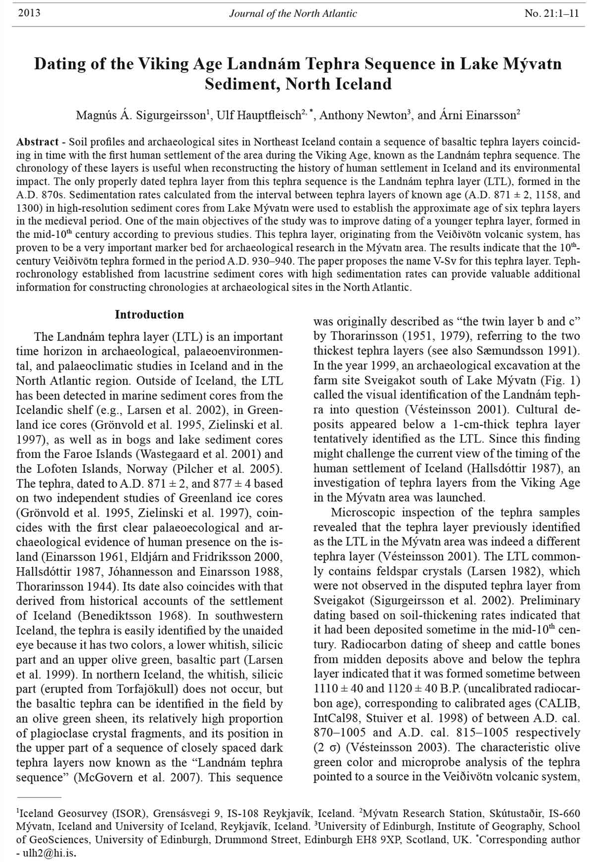
Figure 2. Soil sections
with tephra layers from
Sellandafjall and the
archaeological site of
Sveigakot (all sections
based on Sigurgeirsson
2001). The capital
letters and colors refer
to the volcanic system
as the source of
the tephra, Veiðivötn
(V, green), Hekla (H,
red), Katla (K, violet),
Grímsvötn (G, blue),
Öræfajökull (Ö, orange),
and Torfajökull
(T, tan). The color code
is based on Óladóttir
et al. (2011a, b) and
Gudmundsdóttir et al.
(2012). Tephra layers
of unknown volcanic
origin are shown in
black.
4 Journal of the North Atlantic No. 21
were not visible because of their resemblance to the
diatomaceous gyttja. In an attempt to locate these
well-dated and important layers, x-ray photographs
were obtained of the SV-1 core. Since it was not
possible to locate all the layers by this method, the
upper half of the core was cut into 0.5-cm slices, and
the lower half was sectioned into 1-cm thick slices,
making for a total of 150 slices in all. Samples from
the 0.5-cm slices were examined carefully with a
stereomicroscope in order to locate any increases in
the amount of silicic tephra in the sediment.
The geochemistry of all sampled tephra layers
from the 2006 core was established by microprobe
analysis of the glass component. Glass shards were
incorporated in resin on a frosted slide and ground
to a thickness of approximately 75 μm and then
polished with 6-μm and 1-μm diamond pastes. The
slides were then carbon coated. All analyses were
undertaken on a five-spectrometer Cameca SX100
electron microprobe at the School of GeoSciences
at the University of Edinburgh and analyzed using
the wavelength-dispersive method. An accelerating
voltage of 10 kV and a beam current of 10 nA
were used. In order to compensate for mobility of
Na during the analysis, a beam diameter of 5 μm
was used and a real-time decay curve correction
Figure 3. X-ray photograph
(a), photograph
(b), and stratigraphic
profile (c) of
sediment core SV-1
from Lake Mývatn.
The 10th-century
Veiðivötn tephra
may be seen at a
depth of 271.5–272
cm below the lake
sediment surface.
Color code and capital
letters are the
same as in Figure
2. Tephra numbers
are the same as in
Table 1.
Table 1. Stratigraphical position of tephra layers from Syðrivog ar, Lake Mývatn. All measurements in cm from lake sediment surface.
Tephra layer
No. Name SV-1 SVA-1 and 2 SVA-3 and 4 SVA-7 SVA-8 SVA-9 and 10
0a V-1477 159.0–162.4 156.0–157.0
0b H-1300 217.0–218.0 217.2–218.0 212.0–212.6 211.7–212.2 224.7–225.1
1 217.5–218.0
2a 232.5–233.0
2b V-1159 232.5–233.0
2c H-1158 232.5–233.0
3 V~950 271.5–272.0 319.5–320.5 313.5–314.5 327.2–327.9
4 V-871 (LTL) 283.5 337.5–338.0 330.6–331.0 304.0–305.0 344.0
5 295.0–295.5 350.0–351.0 343.5–344.5 358.0–358.9
6 299.3–299.5 356.8–357.0 362.8
7 300.5–301.0 359.0–359.3 365.8
8 308.0 395.0–395.3 396.8
2013 M.Á. Sigurgeirsson, U. Hauptfleisch, A. Newton, and Á. Einarsson 5
(Nielsen and Sigurdsson 1981) was carried out by
the microprobe’s Peak Sight software. It should be
pointed out that most of the tephra layers analyzed
were of basaltic composition and therefore suffer
little or no Na-mobility problems during a typical
analysis. Standard basaltic glasses (TbIG [terbium
iron garnet] and a Lipari obsidian fragment) were
analyzed throughout the analytical session to check
for instrument stability and correct for it. A total of
6 to 10 tephra grains per sample were analyzed.
Results
All tephra layers mentioned in this study had
sharp and clear upper and lower
boundaries to the gyttja.
The Hekla tephra H-1300,
previously detected in soils of
the Mývatn area (Einarsson
et al. 1988) and in the pilot
study (Á. Einarsson, 2005
unpubl. data), was not found
in core SV-1, indicating that
its top predates A.D. 1300. As
expected, still younger tephra
layers (V-1477 and V-1717)
prominent in the Mývatn sediment,
and found in the pilot
study, were also absent from
core SV-1.
Increases in the amounts
of silicic tephra were detected
by the microscopic examination
of the SV-1 core at
232.5–233.0 cm and 242.5–
243.0 cm from the sediment
surface. The analysis of the
lighter-colored tephra from
232.5–233.0 cm (Tephra 2c)
revealed a definitive chemical
signature of Hekla-1158
(Fig. 4). The eruption date A.D. 1158 of this silicic
tephra layer from Hekla was derived from the medieval
Konungsannáll (King’s Chronicle [Storm
1888]) by Thorarinsson (1968) (see also Larsen
2002). Hjartarson (1989) found that the precise
records of the medieval annals of comets and solar
eclipses indicated their reliability.
In total, eight basaltic tephra layers, dark gray
and gray-greenish in color, were identified in core
SV-1 (Fig. 3). All of them were easily visible to
the unaided eye. The microprobe analyses indicate
that the basaltic tephra layers in the core originated
from three different volcanic systems: Veiðivötn,
Grímsvötn, and Katla (Table 2, Fig. 5). The origin
Figure 4. Silicic tephra layer from core SV-1 from Syðrivogar, plotted as raw data on
a TiO2/FeO diagram. Previous analyses of the H-1104, H-1158, and H-1300 tephra are
from Larsen et al. (1999) and Larsen (2002).
Table 2. Glass chemistry (mean %) determined by electron microprobe analyses of tephra layers in the sediment core SV-1 from Syðrivogar,
Lake Mývatn and from soil sections at Sellandafjall and the archaeological site of Sveigakot (data from Sellandafjall and Sveigakot from
Sigurgeirsson [2001]). n = number of tephra grains analysed. Origin = volcanic system.
Tephra layer n SiO2 TiO2 Al2O3 FeO MnO MgO CaO Na2O K2O P2O5 Total Origin
1 6 49.63 1.85 13.55 11.71 0.21 6.93 11.45 2.27 0.22 0.23 98.05 Veiðivötn
2a 5 49.93 2.32 13.56 11.33 0.24 6.48 10.96 2.51 0.33 0.31 97.96 Grímsvötn
2b 4 49.74 1.73 13.15 11.35 0.26 7.20 11.83 2.18 0.18 0.22 97.82 Veiðivötn (V-1159)
2c 20 68.18 0.49 14.25 5.62 0.16 0.44 3.06 2.55 4.46 0.10 99.32 Hekla (H-1158)
3 10 49.63 1.84 13.5 11.37 0.18 6.93 11.46 2.41 0.22 0.24 97.78 Veiðivötn (V~950)
4 10 49.52 1.88 13.45 12.01 0.24 6.59 11.17 2.37 0.24 0.22 97.69 Veiðivötn (V-871)
5 8 49.73 3.54 12.52 14.12 0.26 4.78 8.76 2.91 0.58 0.42 97.62 Grímsvötn
6 10 49.29 2.10 13.98 10.67 0.20 7.18 11.86 2.45 0.28 0.25 98.26 Grímsvötn
7 10 47.11 4.70 12.57 13.85 0.25 5.01 9.49 2.97 0.78 0.58 97.31 Katla
8 7 47.06 4.70 12.35 13.83 0.24 4.87 9.51 2.94 0.79 0.56 96.85 Katla
Sellandafjall 3 50.53 1.81 13.4 12.41 - 6.93 11.81 2.43 0.28 0.19 99.78 Veiðivötn (V~950)
Sveigakot 5 49.67 1.77 13.4 12.40 - 6.86 11.62 2.22 0.23 0.23 98.39 Veiðivötn (V~950)
6 Journal of the North Atlantic No. 21
of tephra layer no. 6 is not easily determined; the
data points are situated in the overlap between the
Veiðivötn and the Grímsvötn data cluster (Fig. 5),
but the high K2O compared to FeO and the low Feo/
TiO2 ratio (see Figure 2 in Óladóttir et al. 2011b)
point to an origin in the Grímsvötn volcanic system.
From the relative stratigraphic position (below
H-1158) and chemical signature of the tephra layers
and by comparison with the established regional
tephrochronology (Einarsson et al. 1988, Sæmundsson
1991, Sigurgeirsson 2001, Thorarinsson 1951),
it is clear that the Veiðivötn tephra layers at 283.5
(Tephra 4) and 271.5–272.0 cm (Tephra 3) in the core
(Fig. 5, Table 2) represent the LTL and the 10th-century
Veiðivötn tephra, respectively. The chemical
composition of the 10th-century Veiðivötn layer
(271.5–272.0 cm) in the core
partly matches that of samples
from the 10th-century
Veiðivötn layer at the Sveigakot
archaeological site and in
a soil profile by Sellandafjall.
The FeO/TiO2 ratio is slightly
higher in the terrestrial sites
than in the sediment core, but
is still largely overlapping
with it (Fig. 6). Only a few geochemical
data of Tephra 3 are
already published and available
for comparison, which
might explain the slight separation
of the data clusters.
The calculated sedimentation
rate between LTL (A.D.
871 ± 2) and H-1158 (taking
the approximate 0.5-mm
thickness of the 10th-century
Veiðivötn tephra into account)
was 0.17 cm/year, or 5.74
years/cm. Applying this rate
for estimating the age of the
10th-century Veiðivötn tephra
gave A.D. 937 ± 6 (95% c.i.)
(Tephra 3, see Tables 1, 3a).
Based on the same sedimentation
rate, the dates of
Figure 5. A TiO2/FeO diagram of basaltic tephra layers from core SV-1 from Syðrivogar.
Outlines of data clusters characteristic for three volcanic systems (Jakobsson 1979;
Larsen 1982; Óladóttir et al. 2008, 2011a, 2011b) are also indicated. Tephra numbers
are the same as in Table 1.
Table 3. The age of the 10th-century Veiðivötn tephra, tephra 1, and tephra 5–8, calculated from sediment-accumulation rates based on two
possible ages of the LTL: a) A.D. 871 (Grönvold et al. 1995) and b) A.D. 877 (Zielinski et al. 1997). The 95% confidence interval (c.i.)
for the age of the 10th-century Veiðivötn tephra was calculated as t x S.E. (S.E. = sample standard deviation divided by SQRT(N-1)). Table
t-value for P = 0.05 and df = 3 was 3.182.
Years between Sedimentation rate Age (A.D.)
Sediment core tephra layer (A.D.) (cm year-1) Tephra 1 V~950 Tephra 5 Tephra 6 Tephra 7 Tephra 8
a. Age calculation based on A.D. 871 ± 2
SV-1 1158–871 0.1736 1241 937.2 804.8 782.9 777.1 733.9
SAV-1/2 1300–871 0.2762 - 932.5 825.7 801.1 797.5 668.3
SAV-3/4 1300–871 0.2601 - 932.9 821.4 - - -
SVA-9/10 1300–871 0.2755 - 929.4 818.4 802.8 - -
Mean 933.0 817.6 795.6 787.3 701.1
95% c.i. ± 5.9 ± 16.6 - - -
b. Age calculation based on A.D. 877 ± 4
SV-1 1158–877 0.1779 1239 941.9 812.1 790.7 785.1 742.8
SAV-1/2 1300–877 0.2801 - 937.7 832.4 808.1 804.5 677.1
SAV-3/4 1300–877 0.2638 - 938 827.4 - - -
SVA-9/10 1300–877 0.2794 934.6 825.1 809.7 - -
Mean 938.1 824.3 802.8 794.8 710.0
95 c.i. ± 5.5 ± 16.6 - - -
2013 M.Á. Sigurgeirsson, U. Hauptfleisch, A. Newton, and Á. Einarsson 7
3a, 4) should be considered as suggested rough ages.
The stratigraphic positions of the LTL and the
10th-century Veiðivötn tephra in core SV-1 were
verified in the sediment cores taken in 2011: SVA-2,
SVA-3, SVA-8, and SVA-9 (Table 1, Fig. 7). Two
additional well-known tephra layers, H-1300 and
V-1477, were detected in these cores and identified
by grain size and color. The age of the 10th-century
Veiðivötn tephra was calculated based on the sedimentation
rate between LTL
(A.D. 871 ± 2) and H-1300
(Table 3a). Cores SVA-1 and
SVA-2 yielded a sedimentation
rate of 0.28 cm/year,
resulting in an age of A.D.
933, and an identical age
was calculated from the sedimentation
rate of 0.26 cm/
year from cores SVA-3 and
SVA-4. A slightly older age
of A.D. 929 was calculated
using the sedimentation rate
of 0.28 cm/year obtained
from SVA-9 and SVA-10.
Using the younger age
for the LTL (A.D. 877 ± 4)
results in slightly increased
sedimentation rates and
dates for the 10th-century
Veiðivötn, which are around
5 years younger (Table 3b).
Combining the ages from the
cores allows us to produce
average age estimates for
the 10th-century Veiðivötn
tephra of A.D. 933 ± 6 (95%
c.i.) using a LTL date of A.D.
871 or A.D. 938 ± 6 (95%
c.i.) for a LTL date of A.D.
877 (Table 3).
Figure 6. A TiO2/FeO diagram of tephra layer 3 (see Table 2) from core SV-1 from Syðrivogar,
and previous analyses of the 10th-century Veiðivötn tephra from Sellandafjall
(red filled circles) and the archaeological site of Sveigakot (red open circles) from Sigurgeirsson
2001. Outlines are the same as in Figure 5.
Table 4. Origin and age of tephra layers in the sediment cores S V-1 and SVA-1, 2, 3, 4, 7, 8, 9, 10 from Syðrivogar , Lake Mývatn.
Tephra layer Origin
No. Name (Volcanic system) Year A.D. Reference
0a V-1477 Veiðivötn 1477 (Layer a) Thorarinsson 1958, 1976.
0b H-1300 Hekla 1300 Thorarinsson 1968.
1 Veiðivötn ca. 1241* This study.
2a Grímsvötn ca. 1167** Óladóttir et al. 2011a.
2b V-1159 Veiðivötn 1159 Larsen 1982.
2c H-1158 Hekla 1158 Thorarinsson 1968 , Larsen 2002.
3 V-Sv Veiðivötn 933 ± 6 *** (Formerly V~950) This study, Sigurgeirsson 2001.
4 V-871 (LTL) Veiðivötn 871 ± 2 and 877 ± 4 (The Landnam layer) Grönvold et al. 1995, Zielinski et al. 1997 .
5 Grímsvötn 817.6 ± 17 *** This study.
6 Grímsvötn 795.6 This study.
7 Katla 787.3 This study.
8 Katla 701.1 This study.
*Calculation based on A.D. 871 ± 2 (Grönvold et al. 1995).
**Calculation based on SAR from Sauðárhraukar (0.1154 cm yr-1; Óladóttir et al. 2011a).
***Mean, calculation based on A.D. 871 ± 2 (Grönvold et al. 1995).
the other hitherto unknown tephra layers in core
SV-1 became A.D. 1241 for Tephra 1, A.D. 805
for Tephra 5, A.D. 783 for Tephra 6, A.D. 777 for
Tephra 7, and A.D. 734 for Tephra 8 (Table 3a). The
13th-century Veiðivötn tephra was only detected in
core SV-1. Concerning the calculated dates of the
tephra layers older than the LTL, it has to be taken
into account that there is no precise chronological
control below the LTL. Hence, these results (Tables
8 Journal of the North Atlantic No. 21
layers and seem older than it actually is). Densityinduced
migration of tephra layers and spatial heterogeneity
in the distribution of the tephra layers
was not observed in the cores from Syðrivogar. The
glass shards of the sampled tephra layers showed no
signs of reworking, as proven by inspection under
the stereomicroscope. The effect of bioturbation
seems to be negligible in the cores from Syðrivogar,
as the cores show no sign of bioturbation (Fig. 8).
The geochemical results are pointing to tephra layers
with homogeneous origin (Table 2). Only Tephra
2 is composed of three different tephra layers. The
sample of Tephra 2b, right above H-1158 (Tephra
2c), contained 4 tephra shards with the geochemical
signature of Veiðivötn and is interpreted as V-1159.
Tephra 2a contained 5 tephra shards from the Grímsvötn
volcanic system (Fig. 5, Table 2). The position
of a Grímsvötn tephra above V-1159 in the sediment
of Lake Mývatn is consistent with the results of
Óladóttir et al. (2011a), who detected a Grímsvötn
Discussion
Despite the ideal conditions at Syðrivogar, there
are problems associated with tephra stratigraphy
in lacustrine sediments. These may arise from spatial
heterogeneity of tephra fallout (Boygle 1999,
Pyne-O’Donnell 2011), reworking of primary tephra
(Boygle 1999, Gudmundsdóttir et al. 2011), and
density-induced migration of tephra into the sediment
(Anderson et al. 1984; Beierle and Bond 2002).
Bioturbation of lake sediments by chironomids, fish,
or waterfowl (Krantzberg 1985, McCall and Tevesz
1982, McLachlan and Cantrell 1976) can disperse
a primary tephra layer in the sediment column. Of
these, only density-induced migration of tephra is
of concern in this study, and only if different tephra
behave differently in this respect. If layer thickness
is a crucial variable, the age of the relatively thick
10th-century Veiðivötn layer should be overestimated
(i.e., it would sink further than the reference
Figure 7. Soil sections with tephra layers from Sellandafjall (a), farm ruins (b), and midden (c) of the archaeological site of
Sveigakot (a–c based on Sigurgeirsson 2001) compared to the stratigraphic position of sediment cores from Syðrivogar with
correlated key tephra layers. Sediment cores: SV-1 (d), SVA-1, 2, 3, 4 (e), SVA-7, 8 (f), and SVA-9, 10 (g). Color code as
in Figure 2; tephra layers of unknown volcanic origin are depicted in black. The scale on the left side is in cm below terrain
edge and on the right side is in cm below the lake sediment sur face.
Figure 8. Photograph of the lower half of sediment core SVA-3. Tephra layers V-Sv (3), LTL (4), and Grímsvötn (5) are
marked. Tephra numbers are the same as in Table 1.
2013 M.Á. Sigurgeirsson, U. Hauptfleisch, A. Newton, and Á. Einarsson 9
the dating results of the 10th-century Veiðivötn
tephra, presented in this paper.
The correlation of Tephra layers 1 and 5–8 with
existing tephrochronologies is uncertain. Tephra 1,
originating from Veiðivötn and dated to ca. A.D
1241 could not be linked to existing marine and terrestrial
tephrochronological records from Iceland.
Tephra 7 (A.D. 787) and Tephra 8 (A.D. 701) originating
from Katla should perhaps be compared to the
Katla layers AT-4 (A.D. 815), AT-5 (A.D. 775), and
AT-8-1 (A.D. 680) detected by Óladóttir et al. (2008)
in soil sections of Atley, east of Mýrdalsjökull (Fig
1A). However, considering the suggested rough ages
of tephra layers no. 5–8, all attempts to correlate the
prehistoric layers to the established tephrochronological
framework are at the present moment highly
speculative. Thus, further tephrochronological research
is needed to link the prehistoric tephra layers
detected in Lake Mývatn to existing tephra records
from outside the Mývatn area and the North Icelandic
shelf.
The name of a historical tephra layer is usually
based on the originating volcanic system and the
eruption date, often derived from historical records.
The age estimation of the 10th-century Veiðivötn
tephra is solely based on calculated sedimentation
rates from lacustrine sediment cores, resulting not
in a single date, but in a narrow time interval. Hence
this paper proposes the name V-Sv (Sv for Sveigakot
and Syðrivogar) for this tephra.
The precise dating of individual layers of the
Landnám tephra sequence, including the V-Sv
tephra, will prove useful for archaeological work
in the Mývatn area. The LTL was deposited right
at the beginning of human settlement of this hitherto
uninhabited island, and the V-Sv was produced
shortly after the formal establishment of a state (the
Commonwealth) according to historical sources.
These two layers frame the settlement period and are
therefore important for the interpretation of the environmental
history of Iceland and the North Atlantic,
and not least the palaeoecology of Lake Mývatn and
surrounding lakes.
This paper adds to the known eruption history of
Iceland and improves the dating of the V-Sv tephra,
but also acknowledges the necessity to discuss the
reliability of the age calculation. Despite known
problems associated with tephrochronological
records derived from lake sediment archives (Anderson
et al. 1984, Beierle and Bond 2002, Boygle
1999, Pyne-O’Donnell 2011), lakes can provide
stable-enough environments for reliable tephra stratigraphies.
Tephrochronological work based on lake
sediment cores truly demands a high technical effort,
but particularly in areas with poor or disturbed soil
records, lacustrine cores provide a valuable alternative
to soil sections.
tephra layer right on top of H-1158 in soil sections at
Sauðárhraukar, Kárahnjúkar, and Snæfell (Fig.1A).
Another potential source of bias is the assumption
that the sedimentation rate was stable over the
period ca. A.D. 730–1160. Dugmore and Buckland
(1991) observed in soil sections in South Iceland
an increase of sediment accumulation immediately
after deposition of the LTL, which then declined
within a couple of centuries. Assuming a similar
change in sediment accumulation in Lake Mývatn, it
would tend to make the tephra seem younger than it
is. However, full-scale soil erosion associated with
human activities started very late in the Mývatn
area, or in the 17th century (Einarsson et al. 1988).
Nevertheless one should expect some erosion to start
soon after the settlement around A.D. 870, leading to
slightly increasing sedimentation rates towards the
reference tephras of H-1158 and H-1300. Lawson
et al. (2007) found evidence of a pulse of nutrient
enrichment in Lake Helluvaðstjörn on the west side
of Mývatn soon after the Norse settlement, which
can probably be ascribed to nutrient mobilization by
grazing or woodland clearance, with actual soil reworking
starting later (ca. A.D. 1200). Any increase
in sedimentation rate due to erosion or enrichment at
this time would lead to an overestimate of the date of
the 10th-century Veiðivötn tephra (i.e., it would seem
older than it is). The results showed a nearly uniform
sedimentation rate between 0.19–0.28 cm/year calculated
for the time interval between the LTL (A.D.
871 ± 2) and H-1300. The age of the 10th-century
Veiðivötn tephra could be narrowed down to a time
interval of A.D. 929–A.D. 937, with a mean of 933,
but as any bias would tend to make it seem earlier
than it is, A.D. 940 may be a more realistic date.
The 10th-century Veiðivötn tephra can be correlated
to a Veiðivötn tephra layer of comparable
age, detected in a few soil sections in North Iceland
and a marine sediment core from the North Icelandic
shelf region. Larsen (1982) describes in soil
sections of Jökuldalur, northeastern Iceland (Fig.
1A) a Veiðivötn tephra dated by soil-accumulation
rates to A.D. 940. Lawson et al. (2007) identified
the 10th-century Veiðivötn layer in a lake sediment
core from Helluvaðstjörn, 6 km SW of Lake Mývatn
(Fig. 1B). The tephra was also traced in nearby soil
sections, but the authors reported disturbance of
the tephra profiles by erosion (Lawson et al. 2007).
Gudmundsdóttir et al. (2012) detected in marine
core MD99-2275 (Fig. 1A) a Veiðivötn tephra layer
positioned between H-1104 and K~920 and dated by
a tephrochronological age model to A.D. 955. Furthermore,
a Veiðivötn layer was detected between
H-1104 and the LTL in the soil section of Svartárkot
and Sauðárhraukar (Fig. 1A; Gudmundsdóttir et al.
2012). The results of Larsen (1982), Lawson et al.
(2007), and Gudmundsdóttir et al. (2012) strengthen
10 Journal of the North Atlantic No. 21
Gudmundsdóttir, E.R., J. Eiríksson, and G. Larsen. 2011.
Identification and definition of primary and reworked
tephra in Late Glacial and Holocene marine shelf
sediments off North Iceland. Journal of Quaternary
Science 26:589–602.
Gudmundsdóttir, E.R., G. Larsen, and J. Eiríksson. 2012.
Tephra stratigraphy on the North Icelandic shelf:
Extending tephrochronology into marine sediments
off North Iceland. Boreas. Available online at DOI
10.1111/j.1502-3885.2012.00258.x.
Hallsdóttir, M. 1987. Pollen analytical studies of human
influence on vegetation in relation to the landnám
tephra in southwest Iceland. Lundqua Thesis 18:1–45.
Lund, Sweden. 45 pp.
Hjartarson, Á. 1989. Halastjörnur, sólmyrkvar, eldgos
og áreiðanleiki annála. [In Icelandic]. (Comets, solar
eclipses, volcanic eruptions, and the reliabililty
of the annals). Árbók Hins íslenzka fornleifafélags
(Yearbook of the Icelandic Archaeological Society).
86:85–100.
Jakobsson, S.P. 1979. Petrology of recent basalts of the
Eastern Volcanic Zone, Iceland. Acta Naturalia Islandica
26:1–103.
Jakobsson, S.P., K. Jónasson, and I.A. Sigurdsson. 2008.
The three igneous rock series of Iceland. Jökull
58:117–138.
Jóhannesson, H., and S. Einarsson. 1988. Krísuvíkureldar
I. Aldur Ögmundarhrauns og miðaldalagsins. [In
Icelandic with English summary]. (The Krísuvík fires
I. The age of the Ögmundarhraun lava flow and the
medieval tephra layer). Jökull 38:71–85.
Jowsey, P.C. 1966. An improved peat sampler. New Phytologist
65:245–248.
Krantzberg, G. 1985. The influence of bioturbation on
physical, chemical and biological parameters in aquatic
environments: A review. Environmental Pollution
(Series A) 39:99–122.
Larsen, G. 1982. Gjóskulagatímatal Jökuldals og nágrennis.
[In Icelandic]. (Tephrochronology of Jökuldalur
and the surrounding areas). Pp. 51–65, In H. Thórarinsdóttir,
Ó.H. Óskarsson, S. Steinthórsson, and Th.
Einarsson (Eds.). Eldur er í norðri. [In Icelandic].
(Fire is in the North). Sögufélag, Reykjavík, Iceland.
462 pp.
Larsen, G. 1984. Recent volcanic history of the Veidivötn
fissure swarm, southern Iceland: An approach to volcanic
risk assessment. Journal of Volcanology and
Geothermal Research 22:33–58.
Larsen, G. 2002. A brief overview of eruptions from
ice-covered and ice-capped volcanic systems in Iceland
during the past 11 centuries: Frequency, periodicity,
and implications. Pp. 81–90, In J.L. Smellie
and M.G. Chapman (Eds.). Volcano-Ice Interactions
on Earth and Mars. Geological Society of London.
Special Publication 202. London, UK. 348 pp.
Larsen, G., A.J. Dugmore, and A.J. Newton. 1999. Geochemistry
of historical-age silicic tephras in Iceland.
The Holocene 9:463–471.
Larsen, G., J. Eiríksson, K.L. Knudsen, and J. Heinemeier.
2002. Correlation of late Holocene terrestrial and marine
tephra markers in North Iceland. Implications for
reservoir age changes and linking land-sea chronologies
in the northern North Atlantic. Polar Research
21:283–290.
Acknowledgments
We thank Johanna Jacobi and Antoine Millet for assistance
with sediment coring, Garðar Guðmundsson with
core sampling in the laboratory, and Guðrún Larsen for
useful information and discussions. Electron microprobe
analyses were carried out at the Tephra Analytical Unit,
School of GeoSciences, University of Edinburgh with the
kind assistance of Dr. Chris Hayward. Finally, we would
like to thank two anonymous reviewers who provided
valuable comments and suggestions on a first version of
this paper.
Literature Cited
Anderson, R.Y., E.B. Nuhfer, and W.E. Dean. 1984.
Sinking of volcanic ash in uncompacted sediment in
Williams Lake, Washington. Science 225:505–508.
Beierle, B., and J. Bond. 2002. Density-induced settling
of tephra through organic lake sediments. Journal of
Paleolimnology 28:433–440.
Benediktsson, J. (Ed.). 1968. Íslendingabók. Landnámabók.
[In Icelandic]. (The Book of Icelanders. The
Settlement Book). Íslenzk fornrit I. Hið íslenzka fornritafélag,
Reykjavík, Iceland. 139 pp.
Boygle, J. 1999. Variability of tephra in lake and catchment
sediments, Svínavatn, Iceland. Global and Planetary
Change 21:129–149.
Dugmore, A.J., and P.C. Buckland. 1991. Tephrochronology
and late Holocene soil erosion in south Iceland.
Pp. 147–159, In J.M. Maizels and C. Caseldine (Eds.).
Environmental Change in Iceland, Past and Present.
Kluwer Academic Publishers, Dordrecht, The Netherlands.
332 pp.
Einarsson, Á., H. Hafliðason, and H. Óskarsson. 1988.
Mývatn: Saga lífríkis og gjóskutímatal í Syðriflóa.
[In Icelandic with English summary]. (Lake Mývatn:
Palaeolimnology and tephrochronology of the Sydriflói
Basin). Mývatn Research Station, Report no. 4.
Náttúruverndarráð, Reykjavík, Iceland. 96 pp.
Einarsson Á., H. Óskarsson, and H. Haflidason. 1993.
Stratigraphy of fossil pigments and Cladophora and its
relationship with tephra deposition in Lake Mývatn.
Journal of Paleolimnology 8:15–26.
Einarsson Á., G. Stefánsdóttir, H. Jóhannesson, J.S.
Ólafsson, G.M. Gíslason, I. Wakana, G. Gudbergsson,
and A. Gardarsson. 2004. The ecology of Lake Myvatn
and the River Laxá: Variation in space and time.
Aquatic Ecology 38:317–348.
Einarsson, Th. 1961. Pollenanalytische Untersuchungen
zur spät- und postglazialen Klimageschichte Islands.
In German. (Pollenanalytical research concerning the
late- and postglacial climate history of Iceland). Sonderveröffentlichungen
des Geologischen Institutes der
Universität Köln. 6, Cologne, Germany. 52 pp.
Eldjárn, K., and A. Fridriksson. 2000. Kuml og haugfé úr
heiðnum sið á Íslandi. In Icelandic. (Graves and Grave
Finds in Pagan Iceland). Mál og menning, Reykjavík,
Iceland. 615 pp.
Grönvold, K., N. Óskarsson, S.J. Johnsen, H.B. Clausen,
C.U. Hammer, G. Bond, and E. Bard. 1995. Ash layers
from Iceland in the Greenland GRIP ice core correlated
with oceanic and land-based sediments. Earth and
Planetary Science Letters 135:149–155.
2013 M.Á. Sigurgeirsson, U. Hauptfleisch, A. Newton, and Á. Einarsson 11
Sigurgeirsson, M.Á., O. Vésteinsson, and H. Hafliðason.
2002. Gjóskulagarannsóknir við Mývatn–aldursgreining
elstu byggðar. [In Icelandic with English
summary]. (Tephrochronological investigation at Lake
Mývatn–establishing the age of the oldest settlements)
Pp. 107–109, In O. Vésteinsson (Ed.) Archaeological
investigations at Sveigakot 2001. Progress report
FS173-00212. Fornleifastofnun Íslands (The Icelandic
Institute of Archaeology), Reykjavík, Iceland. 118 pp.
Storm, G. (Ed.). 1888. Islandske Annaler indtil 1578.[ In
Danish]. (Icelandic Annals until 1578). Gröndal and
Söns Bogtrykkeri, Christiania (Oslo), Norway. 667 pp.
Stuiver, M., P.J. Reimer, E. Bard, J.W. Beck, G.S. Burr,
K.A. Hughen, B. Kromer, G. McCormac, J. van der
Plicht, and M. Spurk. 1998. INTCAL98 Radiocarbon
Age Calibration, 24000-0 cal BP Radiocarbon
40:1041–1083.
Thorarinsson, S. 1944 Tefrokronologiska studier
på Island. Þjórsárdalur och dess förödelse. [In
Swedish]. (Tephrochronological studies in Iceland.
The Þjórsárdalur valley and the destruction of its
settlement). Geografiska Annaler 1–2:1–217.
Thorarinsson, S. 1951. Laxárgljúfur and Laxárhraun:
A tephrochronological study. Geografiska Annaler
33:1–89.
Thorarinsson, S. 1958 The Öræfajökull eruption of 1362.
Acta Naturalia Islandica II (2). 100 pp.
Thorarinsson, S. 1968. Heklueldar. [In Icelandic].
(Eruptions in Hekla). Sögufélag, Reykjavík, Iceland.
185 pp.
Thorarinsson, S. 1976. Þáttur af Þegjandadal. [In Icelandic].
(A story from Þegjandadalur). Pp. 461–470, In G.
Kolbeinsson (Ed.). Minjar og menntir. [In Icelandic]
(Antiquities and Knowledge). Bókaútgáfa Menningarsjóðs,
Reykjavík, Iceland. 576 pp.
Thorarinsson, S. 1979. The postglacial history of the Mývatn
area. Oikos 32:17–28.
Vésteinsson, O. (Ed.). 2001. Archaeological investigation
at Sveigakot 1998–2000. Pp. 4–12, In O. Vésteinsson
(Ed.) Archaeological investigations at Sveigakot
1998–2000. Progress report FS134-00211. Fornleifastofnun
Íslands, Reykjavík, Iceland. 72 pp.
Vésteinsson, O. 2003. Archaeological investigation at
Sveigakot 2002. Progress report FS206-00213. Fornleifastofnun
Íslands, Reykjavík, Iceland. 83 pp.
Wastegaard, S., S. Björck, M. Grauert, and G.E. Hannon.
2001. The Mjáuvøtn tephra and other Holocene tephra
horizons from the Faroe Islands: A link between the
Icelandic source region, the Nordic Seas, and the
European continent. The Holocene 11:101–109.
Zielinski G.A., P.A. Mayewski, L.D. Meeker, K. Grönvold,
M.S. Germani, S. Whitlow, M.S. Twickler, and K.
Taylor. 1997. Volcanic aerosol records and tephrochronology
of the Summit, Greenland, ice cores. Journal
of Geophysical Research 102:26, 625–626, 640.
Lawson, I.T., F.J. Gathorne-Hardy, M.J. Church, A.J.
Newton, K. J. Edwards, A.J. Dugmore, and Á. Einarsson.
2007. Environmental impacts of the Norse settlement:
Palaeoenvironmental data from Mývatnssveit,
northern Iceland. Boreas 36:1–19.
McCall, P.L., and M.J.S. Tevesz. 1982. The effects of benthos
on physical properties of freshwater sediments.
Pp. 105–176, In P.L. McCall and M.J.S. Tevesz (Eds.):
Animal-Sediment Relations. The Biogenic Alteration
of Sediments. Plenum Press, New York, NY, USA.
336 pp.
McGovern, T.H., Ó. Vésteinsson, A. Fridriksson, M.
Church, I. Lawson, I.A. Simpson, Á. Einarsson, A.
Dugmore, G. Cook, S. Perdikaris, K.J. Edwards, A.M.
Thomson, W.P. Adderley, A. Newton, G. Lucas, R. Edvardsson,
O. Aldred, and E. Dunbar. 2007. Landscapes
of settlement in northern Iceland: Historical ecology
of human impact and climate fluctuation on the millennial
scale. American Anthropologist 109:27–51.
McLachlan, A.J., and M.A. Cantrell. 1976. Sediment
development and its influence on the distribution and
tube structure of Chironomus plumosus L. (Chironomidae,
Diptera) in a new impoundment. Freshwater
Biology 6:437–443.
Nielsen, C.H., and H. Sigurdsson. 1981. Quantitative
methods for the electron microprobe analysis of sodium
in natural and synthetic glasses. American Mineralogist
66:547–52.
Óladóttir, B.A., O. Sigmarsson, G. Larsen, and Th. Thordarson.
2008. Katla volcano, Iceland: Magma composition,
dynamics, and eruption frequency as recorded
by Holocene tephra layers. Bulletin of Volcanology
70:475–493.
Óladóttir, B.A., G. Larsen, and O. Sigmarsson. 2011a. Holocene
volcanic activity at Grímsvötn, Bárdarbunga,
and Kverkfjöll subglacial centres beneath Vatnajökull,
Iceland. Bulletin of Volcanology 73:1187–1208.
Óladóttir, B.A., O. Sigmarsson, G. Larsen, and J.L. Devidal.
2011b. Provenance of basaltic tephra from Vatnajökull
subglacial volcanoes, Iceland, as determined
by major- and trace-element analyses. The Holocene
21:1037–1048.
Ólafsdóttir, R., and H.J. Guðmundsson. 2002. Holocene
land degradation and climatic change in northeastern
Iceland. The Holocene 12:159–167.
Pilcher, J., R.S. Bradley, P. Francus, and L. Anderson.
2005. A Holocene tephra record from the Lofoten Islands,
Arctic Norway. Boreas 34:136–156.
Pyne-O’Donnell, S. 2011. The taphonomy of Last Glacial-
Interglacial Transition (LGIT) distal volcanic ash
in small Scottish lakes. Boreas 40:131–145.
Sæmundsson, K. 1991. Jarðfræði Kröflukerfisins. [In
Icelandic]. (Geology of the Krafla volcanic system).
Pp. 25–95, In A. Gardarsson and Á. Einarsson (Eds.).
Náttúra Mývatns. [In Icelandic]. (The Natural History
of Lake Mývatn). Hið íslenska náttúrufræðifélag (The
Icelandic Society of Natural Science), Reykjavík,
Iceland. 372 pp.
Sigurgeirsson, M.Á. 2001. Greinargerð um gjóskulög. [In
Icelandic with English summary]. (Tephrochronological
research). Pp. 39–42, In O. Vésteinsson (Ed.) Archaeological
Investigations at Sveigakot 1998–2000.
Progress report FS134-00211 Fornleifastofnun Íslands
(The Icelandic Institute of Archaeology), Reykjavík,
Iceland. 72 pp.