Restoration of the Hvalsey Fjord Church
Georg Nyegaard*
Abstract - Since the fi rst visits by Europeans to the ruin of the Hvalsey Fjord Church after the beginning of the Danish-
Norwegian colonization of Greenland in 1721 there are numerous descriptions of a crack in the east gable of the church
and a corresponding tilt damage of the eastern part of the south wall. As a new investigation of the church showed that the
south wall was not stable, a restoration project was carried out in 1999, where the leaning wall was partly straightened and
stabilized with concrete cast underneath the foundation stones. An archaeological excavation along the south wall prior to
the restoration documented that the eastern part of the wall partly rests on older graves, indicating that the stone church must
have had a predecessor of which no traces have been found. The presence of these graves beneath some of the foundation
stones is assumed to be the main cause for the damage to the wall.
*The Greenland National Museum and Archives, Hans Egedesvej 8, PO Boks 145, 3900 Nuuk, Greenland; georg.nyegaard@
natmus.gl.
Introduction
The Hvalsey Fjord Church is the best-preserved
Norse ruin in Greenland. It is built of local granite
stones, and the masonry remains almost complete,
with gables standing up to about 5.5 m high
(Berglund 1982, Clemmensen 1911, Krogh 1982).
The monumental ruin has almost become an icon
of the medieval Nordic settlement of Greenland
and especially of its extinction some time during
the 15th century.
As is always the case in Norse Greenland, the
church is closely associated with the ruins of a farm.
The hall of this farm has equally well-preserved
walls constructed in a very similar way as the church.
Architecturally, the two ruins show so much affi nity
with both Norway and the islands of northern Scotland,
that it must be assumed that an architect from
abroad had been involved in the construction of the
buildings. The choir window of the church terminates
at the top with a segmental arch, which is a
stylistic trait that is unparalleled in Norse Greenland
and very much in keeping with church architecture
on the continent. The church thus demonstrates surprising
internationality despite the remoteness of the
locality in relation to the medieval cultural centers
in Europe (Nord 1996:31, 82). It is assumed to have
been built around 1300, and must be seen as an expression
of a certain economic and cultural capacity
and strength at this relatively late stage of the Norse
settlement history in Greenland.
Icelandic documents containing the last written
evidence for life in Norse Greenland tell of the wedding
that took place in the Hvalsey Fjord Church
on September 16th in 1408 between the Icelanders
Sigríður Björnsdóttir and Þorsteinn Ólafsson. The
documents also testify that this couple left Greenland
two years later.
The Hvalsey Site in the 18th and 19th Century
The old Greenlandic name of the site is Qaqortoq,
which means the color white. The suffi x -kulooq
was added in very recent time changing the
name to Qaqortukulooq, meaning “the big white,”
to facilitate a distinction between the names of this
locality and the nearby town of Qaqortoq. Qaqortoq
is not a common place-name in Greenland, but no
certain explanation of the name is known. According
to some local Greenlanders, the fjord beside the
ruin group was called “Qaqortoq”, or “Qaqortup
Imaa” (Imeq meaning water) in the fi rst half of the
19th century, because the church in the old days appeared
so bright white that it could be seen from a
great distance (GHM III 1845:821). Traces of lime
mortar have repeatedly been demonstrated between
the stones of the masonry (Clemmensen 1911:298,
Egede 1925:99, Graah 1932:54, Krogh and Abrahamsen
1997). So perhaps the fi rst Inuit who visited
the place— perhaps in the 14th or 15th century according
to the earliest datings of the Thule culture
in South Greenland (Gulløv 2005:316)—gave it a
name from what they saw: a whitewashed church.
If this is true, even the name of South Greenland’s
biggest town, Qaqortoq, situated near the entrance of
the Qaqortup Imaa, might indirectly derive from the
former appearance of the church.
The fi rst known visit by Europeans to the site
since the Norse abandonment, took place in 1723.
Two years after his arrival to Greenland, the Norwegian
missionary Hans Egede went on an expedition
to fi nd the Norse Eastern Settlement (Egede 1925).
After an unsuccessful attempt to reach East Greenland,
where at the time it was thought this settlement
lay, he spent a couple of days at the Hvalsey site in
late August together with his boat crew and a group
of locals. Egede’s account of the journey includes a
description of the church and the stone-built hall. A
2009 Special Volume 2:7–18
Norse Greenland: Selected Papers from the Hvalsey Conference 2008
Journal of the North Atlantic
8 Journal of the North Atlantic Special Volume 2
small and very superfi cial excavation, without the
use of proper tools, was carried out in the interior
of the church. Only a little charcoal and a few bone
fragments were found.
Not until over a century after Egede’s journey
was the correct location of the Eastern Settlement
in South Greenland west of Cape Farewell established,
after the Danish First Lieutenant W.A.
Graah’s expedition to East Greenland from 1828–
31, where he did not find any remains of Norse settlement
(Graah 1932). During the preparations for
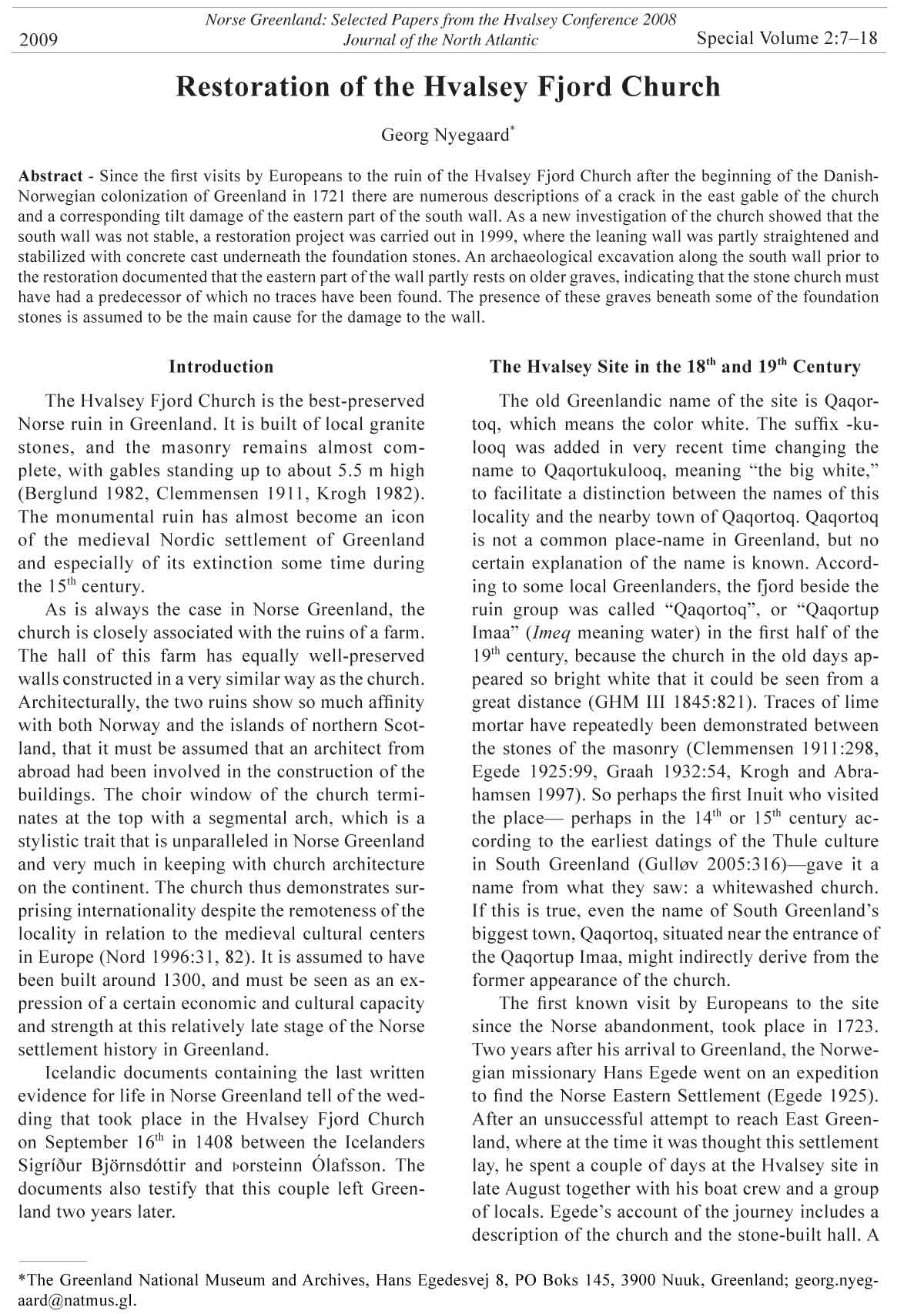
his journey, Graah visited the Hvalsey site in 1828.
In his expedition account from 1832, he included
a detailed description of the church, accompanied
by copperprint illustrations after versions done by
the antiquarian artist H.G.F. Holm on the basis of
Graah’s own sketches (Fig. 1).
Already, Egede had mentioned a crack in the
east gable in the southeastern corner of the building,
which can be seen in the picture from Graah’s
publication (Fig. 2). Graah also speaks of this and of
the leaning south wall. He thought that the damage
had arisen as a result of the slightly sloping terrain
and predicted of the south wall “that it would
hardly for another half century resist the destroying
winds” (translated from Danish) (Graah 1932:55).
An excavation was conducted inside the church,
which according to Graah “occupied 21 people for
12 hours” (Graah 1932:56). Most of the soil was
turned over, but again only a few remains of bones
and some charcoal were found.
After the foundation of the town of Qaqortoq as
the colony of Julianehaab in 1775, the Hvalsey site
repeatedly received visits by the members of the
staff of the Danish trading company and the mission.
Many small-scale excavations and diggings
like Egede’s took place during these visits, especially
in the interior of the church. A water-color
belonging to the National Museum of Denmark
(Fig. 3) could be the oldest preserved picture of
the site. It is assumed to have been made by Jens
Mathias Mathiessen, who worked for The Royal
Greenland Trading Company in 1820–33, some of
the time in Qaqortoq. He also took part in Graah’s
visit to the site in 1828.
The oldest situation plan known of the ruin group
was published in 1845 (GHM III 1845:Table VII)
(Fig. 4A). It was done by pastor J.F. Jørgensen, who
lived in Qaqortoq in 1835–41. He was one of the most
important informants for the overview of the ruins
of the Eastern Settlement in the ambitious publication,
Grønlands Historiske Mindesmærker I–III from
1838–1845 (The Historical Monuments of Greenland),
whose main content is otherwise all the written
sources for the Norse history of Greenland known at
the time.
Figure 1. The Hvalsey Fjord Church seen from the north. Copperprint from 1832. Courtesy of the National Museum of
Denmark.
2009 G. Nyegaard 9
Figure 2. The east gable of the Hvalsey Fjord Church. Copperprint from 1832. Courtesy of the National Museum of Denmark.
Figure 3. A water-color of the Hvalsey site assumed to have been made by Jens Mathias Mathiessen about 1830. Courtesy
of the National Museum of Denmark.
10 Journal of the North Atlantic Special Volume 2
Figure 4. A. The fi rst published situation plan of the ruin group in Grønlands Historiske Mindesmærker III, 1845. B. Roussell’s
(1941) situation plan of the ruin group after Arneborg (2006). The church is ruin 8 and the dwelling is ruin 6. C. Niels
Christian Clemmensen´s situation plan of the ruin group from 2004.
2009 G. Nyegaard 11
During an expedition to Greenland in 1876,
the Danish geologist Andreas Kornerup made the
detailed drawings of the church shown in Figures
5 and 6 (after originals at the National Museum of
Denmark). In particular, the latter, showing the east
gable from the inside, gives a clear impression of the
leaning south wall.
Figure 5. The Hvalsey Fjord Church seen from the east. Drawing from 1876 by Andreas Kornerup. Courtesy of the National
Museum of Denmark.
Figure 6. The inside of the
east gable of the Hvalsey
Fjord Church. Drawing from
1876 by Andreas Kornerup.
Courtesy of the National Museum
of Denmark.
12 Journal of the North Atlantic Special Volume 2
The Hvalsey Site in the 20th Century
In the summer of 1910, the architect Mogens
Clemmensen carried out an extensive investigation
of the church for the National Museum of Denmark—
the fi rst by a specialist (Clemmensen 1911).
He did a careful survey and made drawings of all the
walls where the stones were meticulously drawn in.
One of Clemmensen’s tasks was to study the state of
the south wall. He measured the maximum inclination
of the wall above the chancel door as about 50
cm. Like geologist Kornerup before him, he did not
think that the inclination of the wall had deteriorated
signifi cantly since Graah’s visit in 1828 and did not
believe there was any imminent risk of collapse.
Like several of his predecessors, Clemmensen dug
inside the church, and in spite of the previous busy
digging activity, he found a little more than 50 cm
below the original fl oor level the remains of a burial,
including the traces of a coffi n.
In 1935 Aage Roussell of the National Museum
of Denmark conducted the most comprehensive archaeological
investigation ever at the site (Roussell
1941). He concentrated on the dwelling and some of
the animal-shed features that lie around in the infi eld,
while the church was not subject to new investigations.
He made a situation plan of the site including
all ruins and the rather complicated excavated dwelling
complex (Fig. 4B). As indicated by the earlier
excavations, preservation of organic remains turned
out to be extremely poor. The list of fi nds includes
surprisingly little, only a relatively small amount of
tools and fragments of soapstone. Accordingly, the
interpretation of the function of most of the rooms
of the dwelling could only be tentative.
In the beginning
of the 1930s, the issue
of the protection
and listing of ancient
monuments was debated
among politicians
in Greenland,
prompted by, among
other things, the
fact that an increasing
number of sheep
farmers were settling
near Norse ruin
groups. The members
of the South Greenland
Council recommended
at a meeting
in Nuuk in 1934 that
steps be taken towards
a protection law for
ruins and monuments
in collaboration with
the Danish National
Museum (Beretninger
og Kundgørelser vedrørende Grønlands Styrelse
nr. 7/1934:358). Consequently, one of Roussell’s
tasks in 1935, beside the excavations at the Hvalsey
site, was to start a systematic marking of ruins situated
near these new farms.
In 1950, a new preservation regulation defi ned
by Danish authorities for both the ruins and the surrounding
area at the Hvalsey site took effect (Kundgørelser
vedrørende Grønlands Styrelse 1950:205).
This protected area included a 500-m wide zone
along the shoreline, reaching 500 m east of the easternmost
ruin and 500 m west of the westernmost
ruin. Fortunately, the present sheep farm, situated
only 1.5 km east of the church ruin, was founded a
few years after the introduction of this regulation.
Stones from this ruin group have never been re-used
for modern house or farm construction as has been
the case at the important Norse sites of Garðar (Igaliku)
and Brattahlíð (Qassiarsuk) before the 1930s.
However, it had been considered at an earlier stage
to use the stones from the church for the buildings
of the Danish trading company in nearby Qaqortoq/
Julianehåb (Clemmensen 1911:309), but fortunately,
this plan was never realised.
The state of the leaning south wall of the church
continued to cause anxiety. In the 1970s, action was
taken when the very conspicuous wooden frame
seen in Figure 7 was set up. Some years earlier,
in 1962, Knud Krogh of the National Museum of
Denmark had laid out four measuring points in the
north and south walls of the church to create a proper
basis for assessing whether the south wall was stable
or not. Since new control measurements some years
later did not show an increase in the inclination of
the wall, the frame was removed again.
Figure 7. The south wall of the church ruin supported by a wooden construction. Photo from
1981 by Kristian Kleist, Qaqortoq.
2009 G. Nyegaard 13
The Restoration
In 1997, Krogh returned to the site together with
the statics expert Søren Abrahamsen. They carried
out a new and more detailed investigation of the
state of the masonry on the basis of Clemmensen’s
registrations and survey in 1910 and Krogh’s own
measuring points from 1962 (Krogh and Abrahamsen
1997). Considering how common it has been
over the years for people to climb and walk along the
top of the walls, as shown in the photo from 1918 of
the inner side of the east gable (Fig. 8), it was a positive
surprise to fi nd how little damage had occurred
since 1910.
In Figure 9, the same section of the wall as it appeared
in 1997 is shown on architect Clemmensen’s
drawing from 1910 (on the left). The red color marks
the stones that were
missing. Stones with
a green color were
inserted in the crack
some time between
1880 and 1910. All
the blue dots show
places where chalk
mortar was demonstrated
in 1997. On
the right is shown
the west gable from
within. Again the red
color shows stones
that were missing in
1997, while the yellow
indicates stones
whose position had
changed a little.
Figure 10 shows
the same two gables
from the outside—
the west gable on
the left and the east
Figure 8. Locals on a visit to the Hvalsey Fjord Church in 1918. Courtesy of The National Mu- gable on the right,
seum of Denmark.
Figure 9. Clemmensen’s (1911) drawing of the inside of the east gable (left) and the west gable (right) as these appeared
in 1997 (Krogh and Abrahamsen 1997). Red color marks missing stones, yellow color marks stones whose position had
changed a little, while stones with a green color were inserted between 1880 and 1910. The blue dots show places where
chalk mortar was demonstrated in 1997.
14 Journal of the North Atlantic Special Volume 2
while Figure 11 shows the south wall. Again, only
limited damage had occurred since 1910. However,
the investigation in 1997 also showed that the south
wall was not stable. On the basis of Krogh’s measuring
points from 1962, it could be calculated that over
the 35 years the top of the wall had moved about 20
mm where the inclination was greatest, that is above
the chancel door. The maximum inclination was
measured to 52 cm. Furthermore, a comparison with
Clemmensen’s drawing of the east gable also suggested
that the southeast corner had subsided further,
with an inclination of a whole 100 mm since 1910.
The Greenland National Museum and Archives
therefore decided to carry out a restoration, and engineer
Abrahamsen drew up an outline proposal for
the straightening and stabilization of the wall.
Since the plan involved casting new concrete
along and some way in under the foundation stones,
the project began in the summer of 1999 with an
archaeological excavation along the south wall,
headed by Krogh (Fig. 12). We opened a 10-m long
and up to 60-cm wide trench along the wall, which
was dug down to the subsoil. In the easternmost 6
m of the trench—where the wall inclined most—
traces of at least nine graves were found (Fig. 13A
and B). Again, the preservation was very poor.
Bones—shown in red color on the plans— were only
preserved as a brownish, slightly sticky powdery
Figure 10. The outside of the east gable (right) and the west gable (left) as documented by Krogh and Abrahamsen (1997).
See legend for Figure 9.
Figure 11. The south wall as documented by Krogh and Abrahamsen (1997). See legend for Figure 9.
2009 G. Nyegaard 15
substance. As can be seen, several of the graves lay
partly under the foundation stones, which are shown
in the drawing with a light red or pink color, while
the yellow color shows the subsoil of sand or gravel.
The deepest grave lay approximately 1 m beneath the
surface under the foundation of the threshold stone
of the door into the chancel, where the inclination of
the wall was greatest. No graves were observed under
the foundation stones west of the chancel door.
The investigation thus showed that the stone
church, dating to perhaps around 1300, was built on
a churchyard that is older than the church itself, suggesting
that the church must have had a predecessor
of which no traces have been found. At the same
time, the presence of the graves below the foundation
stones shows why the eastern part of the south
wall exhibits tilt damage. The damage arose when
the graves “settled,” and might to some extent already
have been visible at the wedding in 1408.
After the archaeological investigation, concrete
was cast in the trench and about 20 cm in under the
foundation stones. At fi ve points, the foundation
Figure 12. Knud Krogh during excavation of the trench along the south wall in 1999. Photograph © Georg Nyegaard.
Figure 13. Knud Krogh´s plan of the eastern part of the excavated trench along the south wall in 1999. Remains of bones
are shown in red color, the foundation stones are shown with a light red or pink color, and yellow color shows the subsoil
of sand and gravel.
16 Journal of the North Atlantic Special Volume 2
Figure 14. Engineer Abrahamsen’s specially designed tool for the restoration of the south wall. Photograph © S. Abrahamsen.
Figure 15. Different sections of the south wall of the church (Abrahamsen 1999). The red color shows the position of the
wall after the righting process, while the blue color indicates the outline of the south east corner.
2009 G. Nyegaard 17
same profi le as Section A. The resulting space along
the front of the wall between the footing stones and
the foundations stones was stabilized with stone
wedges. The stones in the crack of the east gable
were numbered and removed during the righting
process and inserted again afterwards.
A picture of the east gable from the same year
(Fig. 16) shows the fi nished result. The concrete
tops along the wall have been removed and the turf
re-established. A check of Krogh’s measuring points
nine years later in September 2008 showed that the
wall has been stable since the restoration.
The Hvalsey Site in the 21th Century
Field work took place again at the site in 2004.
Niels Christian Clemmensen from the Heritage
Agency of Denmark made a modern GPS-based
survey of the site in collaboration with the Qaqortoq
Museum and Jette Arneborg of the National
Museum of Denmark. The result of this is shown in
Figure 4C.
From 2004–2007, a new hydro power plant was
built at Qorlortorsuaq, about 40 km east of Qaqortoq.
The plant supplies the towns of Qaqortoq and
Narsaq with electricity. The construction of the power
line posed a potential threat for the ruin group at
the Hvalsey Fjord Church because the only solution
possible was to let the cables pass here. Fortunately,
cementing was furnished with box-shaped tops that
were meant to function as foundations for bracing
up the wall. Figure 14 shows engineer Abrahamsen’s
specially designed tool for the job. It consisted of a
vertical lifting column with a 30-ton jack below it.
With a system of lifting and holding wires and an
angled iron beam that was mounted below the footing
stone, the wall was lifted. To prevent a cave-in
of the foot of the wall on the other side, the wire at
the end of the iron beam was passed through the wall
and around an approximately 2-m long chocked-up
wooden beam at the back that held the foot of the
wall during lifting.
To the lifting column, an iron stay was attached,
and below this another 30-ton jack was installed.
This second jack exerted its pressure on a tensioning
mat lined with wood that was mounted on the lifting
column and which could be placed at different
heights on the wall.
It turned out to be possible to push and lift the
wall as much as needed (Abrahamsen 1999). But to
make the restoration as gentle and discreet as possible,
it was decided to stop the righting process when
the wall contour lay within the profi le shown in blue
in Figure 15, which is the outline of the SE corner. In
this position, Wall Section A (No. 2 from the right)
was pushed 30 cm in at the top of the wall and lifted
6 cm at the front edge of the base. The sections B,
C, D, and E were then braced up according to the
Figure 16. The east gable seen from the east after the restoration. Photograph © Georg Nyegaard.
18 Journal of the North Atlantic Special Volume 2
Nord. 1996. Nordic World Heritage. Proposals for new
areas for the UNESCO World Heritage List. Nordic
Council of Ministers, Copenhagen, Denmark.
Roussell, Aa. 1941. Farms and Churches in the Medieval
Norse Settlements of Greenland. Meddelelser om
Grønland 89(1).
it was decided to lay it in the subsoil over a distance
of about 2 km north of the ruins near the foot of the
Qaqortoq Mountain. So any severe damage to the
site was avoided.
Acknowledgments
The restoration of the Hvalsey Fjord Church was supported
economically by the Danish Ministry of Environment
and “A.P. Møller og Hustru Chastine Mc-Kinney
Møllers Fond til almene Formål.” Knud Krogh kindly
provided the author with non-published documentation
from the archaeological excavation along the south wall
of the church in 1999. Søren Abrahamsen kindly gave the
permission to reproduce drawings from his reports to the
Greenland National Museum and Archives, while Niels
Christian Clemmensen kindly provided the author with a
plan from the surveying in 2004.
Literature Cited
Abrahamsen, S. 1999. Stabilisering af kirkeruinen på
Hvalsø. Afl everingsnotat vedrørende opspænding af
det udvæltede sydmursparti. Rapport til Grønlands
Nationalmuseum and Arkiv, Højbjerg, Greenland.
Arneborg, J. 2006: Saga Trails. Brattahlið, Garðar, Hvalsey
Fjord’s Church, and Herjolfsnæs: Four Chieftain’s
Farmsteads in the Norse Settlements of Greenland. A
Visitor’s Guidebook. Vintervå, Narsaq, Greenland.
Beretninger og Kundgørelser vedrørende Grønlands
Styrelse, nr. 7, 1934. In Beretninger og Kundgørelser
vedrørende Kolonierne i Grønland for Aarene 1933–
1937. København, Denmark. 1938.
Berglund, J. 1982. Hvalsø—The Church and the Magnate’s
Farm. Qaqortoq Kommune,Qaqortoq, Greenland.
Clemmensen, M. 1911. Kirkeruiner fra Nordbotiden m.m.
i Julianehaab Distrikt. Undersøgelsesrejse i Sommeren
1910. Meddelelser om Grønland 47:8, 285–358.
Egede, H. 1925. Relationer fra Grønland 1721–36 og Det
gamle Grønlands ny Perlustration 1741. Pp. 1–404, In
L. Bobé (Ed.). Meddelelser om Grønland 54.
Grønlands Historiske Mindesmærker (GHM). 1838–45.
I–III. Det Kongelige Nordiske Oldskriftselskab. Det
Brünnichske Bogtrykkeri, Kjøbenhavn, Denmark.
(Fasimile 1976; Rosenkilde og Bagger).
Graah, W.A. 1932: Undersøgelses-reise til Østkysten
af Grønland. Efter kongelig befaling udført i aarene
1828–31. København. (Reprint of publication from
1832 , K.Birket-Smith [Ed.]).
Gulløv, H.C. (Ed.). 2005. Grønlands Forhistorie. Gyldendal,
København, Denmark.
Krogh, K. 1982. Erik den Rødes Grønland. Nationalmuseets
Forlag, København, Denmark.
Krogh, K., and Abrahamsen, S. 1997. Notater vedrørende
undersøgelser og sikring af Hvalsey- fjordens Kirke
august 1997. Rapport til Grønlands Nationalmuseum
and Arkiv, Højbjerg, Greenland.
Kundgørelser Vedrørende Grønlands Styrelse. 1950.
Cirkulære af 20. maj 1950 angående fredlysning af
Qaqortoq Kirkeruin og Sigssardlugtoq-ruinen (p.205).
København, Denmark.