24 Journal of the North Atlantic Special Volume 2
1National Museum of Denmark, Danish Middle Ages and Renaissance, Frederiksholm Kanal 12, DK-1220 Copenhagen K, Denmark.
2Greenland National Museum and Archives, Box 145, GR-3900 Nuuk, Greenland. 3KUAS, The Heritage Agency of Denmark,
H.C. Andersens Boulevard 2, DK-1533 Copenhagen V, Denmark. *Corresponding author - jette.arneborg@natmus.dk.
Introduction
The Hvalsey Fjord farmA has all the elements of
a high-status farm. First and foremost is the impressive
church, but there is also the feasting hall, where
the farmer entertained his guests, the store house by
the shore where commodities for foreign trade were
kept, and the large byres for the prestigious cattle.
Still, compared to high-status farms such as the Bishop’s
see Garðar in Igaliku and Brattahlið in Qassiarsuk
(Arneborg n.d.), the Hvalsey Fjord farm is small
in terms of the number of ruins, and that may have
been the reason why the Danish architect Aage Roussell
in 1935 suggested that the neighbouring group
of ruins at Ø83a must have been a part of the Hvalsey
farm, calling them “the dairy farm,”B while the main
cluster he accordingly called the “home farm.”
In 2004, in connection with new surveys at the
Hvalsey Fjord farm and church (Ø83), the “the dairy
farm” (Ø83a) was also surveyed briefl y, and four
small test pits were made in two of the ruins. The
primary aim was to assess the state of preservation
of the ruins and to recover samples for AMS radiocarbon
dating.C
In the following, we report on the 2004 test excavations
at the “dairy farm” and discuss Roussell’s
conception of a “home farm” and “dairy farm.”
The Site
The site Ø83a is ca. one kilometer east of the
Hvalsey Fjord farm and church, and close to the entrance
of the inlet Tasiusaq (Fig. 1). Today, the site
has been affected by the activities of a sheep-farm in
the same location. When Roussell (1935) was there
in 1935, he described the site as one of the most
luxuriant he had ever seen in Greenland. And it was
one of the largest as well.
The farm buildings were built on small dry rises
on the north side of two small lakes, and with one
exception, all faced the lakes.
Research History
In total, Roussell (1935) recorded eight Norse
ruins (numbered 17–24), three outdoor cooking pits,
an Inuit naanngisat (“hopping stones”), and “numerous”
Inuit ruins on the site (Fig. 2).
Already in 1964, ruin 24 and the Inuit naanngisat
had disappeared (Thorvildsen 1964), and in 2004,
we were not able to fi nd the ruins 18, 19, and 23.
The area of the three last-mentioned ruins has been
cultivated recently, and the ruins very likely have
been removed in this connection. In addition to our
work in 2004, Vésteinsson (2008:24–26) described
the site in 2005.
In 1935, Roussell excavated in ruins 20, 21, and
22. He reports that they excavated “quite a lot” in
ruin no. 20 to fi nd out if it was the dwelling of the
farm. According to Roussell, the walls were made
of rather small stones and solid turf walls, and the
conclusion was that the eastern part of the ruin might
have been that of a small, separate house. The western
part of the house was a byre—a stone slab used
as a stall partition was still standing in situ—and on
the fl oor there was evidence for drainage. In front of
the house, on the south side, there was a fairly large
area paved with fl agstones. Apart from the above
mentioned, Roussell could not establish room separations,
and he concluded that the house was a byre
with a barn.
In a minor “test pit” in the “lower end” of ruin
21, Roussell unearthed a fl agged fl oor, and the same
was the case in ruin 22, were he dug “some test pits.”
Immediately north of ruin 20, two large cooking pits
were excavated. After excavation, the most southerly
and the larger of the two was—according to
Roussell—the “nicest,” and was therefore reported
in detail. The pit was almost circular with a diameter
of about 140 cm at the rim. The diameter at the fl at
base was about 65 cm. The sides were straight and
partly lined with fl at slabs. The bottom of the pit was
The “Dairy Farm” of the Hvalsey Fjord Farm
Jette Arneborg1,*, Fuuja Larsen2, and Niels-Christian Clemmensen3
Abstract - Based on his archaeological investigations in 1935 at the Hvalsey Fjord farm and church (ruin group Ø83) and
at the neighbouring ruins (ruin group Ø83a), the Danish architect Aage Roussell linked the two sites together, stating that
the Ø83a buildings had functioned as a subsidiary “dairy farm” to the main farm at Hvalsey (Ø83). Excavations in 2004
showed that the buildings at Ø83a had been in use for a short period only, and artifacts found in 1935 together with the layout
and design of the houses point to a date in the early period of the Norse settlement. Roussell did not identify a dwelling
at Ø83a, but we argue that one of the houses at Ø83a could have been a dwelling and that the two sites—the Hvalsey Fjord
farm (Ø83) and Ø83a—were two individual farms. We suggest that the Ø83a-farm most probably was the predecessor of
the Ø83 Hvalsey farm. For unknown reasons, the earlier farm was moved to the Ø83 site.
2009 Special Volume 2:24–29
Norse Greenland: Selected Papers from the Hvalsey Conference 2008
Journal of the North Atlantic
2009 J. Arneborg, F. Larsen, and N.-C. Clemmensen 25
covered with a 5 cm thick layer of charcoal. Apart
from the charcoal, there were no fi nds in the pits. A
smaller pit south of ruin 21 also contained a few animal
bones. Because he could not identify a dwelling,
Roussell concluded that the site could not have been
an independent farm.
The 1935 excavations produced only eight
artifacts:D A spindle-whorl of soapstone (Fig. 3), a
line-sinker for fi shing (Fig. 4), a pad of soapstone
for repairing soapstone vessels, and a sherd from a
soapstone vessel. In addition, a few small pieces of
iron nails were collected. The sinker is of soapstone
and has vertical groves for the fi shing line. Linesinkers
are rare in the Norse Greenlandic context,
with only two others known. A similar weight was
found in the hall (room I) in the living house of ruin
group Ø29a at Eric the Red’s Brattahlið in Qassiarsuk
(Danish National Museum register), and
another one was found in the midden at the supposed
nunnery, ruin group Ø149, at Narsarsuaq in Uunartoq
Fjord (Vebæk 1991a:79, fi nd no. 179; Vebæk
1991b:13).
The 2004 Excavations
In 2004, four small trenches were dug, one trench
(unit 20.1) in ruin 20, and three trenches (units
22.1–3) in ruin 22E (Fig. 5).
In ruin 20, a 1-m wide and 4-m long trench was
cut through the northern wall in the central part of
the building. The wall was ca. 1.2 m thick and built
of two rows of medium-sized stones with turf-blocks
in-between. In this location,
Roussell had very clearly
excavated the inside of the
house down to natural subsoil,
leaving no undisturbed
cultural layers. Outside the
wall, there was a ca. 30-cm
thick layer of turf collapse
with very few stones. The
subsoil consisted of coarse
grey to yellow gravel, and
on top of that and under
both the wall and the collapse
layer there was a thin,
unbroken vegetation layer
representing what seems
to have been the original
surface. No signs of activity
on top of the vegetation
layer outside the house
were identifi ed.
Three small trenches
were placed in ruin 22. Unit
22.1 (1 x 4 m) was dug inside
the building up against
the north wall. As in ruin 20,
the ca. 1.5-m thick wall was
constructed of two rows of
medium-sized stones with
an inner core consisting of
a mixture of subsoil (coarse
grey to yellow gravel) and
bits and pieces of fossil
vegetation layer. The level
of the fl agged fl oor was ca.
30 cm below the base of
the wall, and evidently the
house had been dug into the
slope, and the material from
the inside of the house used
Figure 1. The central part of the Norse Eastern Settlement. to construct the walls.
26 Journal of the North Atlantic Special Volume 2
Unit 22.2 in ruin 22 cut through the ca. 1.5-m
thick south wall. The trench was 1 x 4 m. Here too,
the wall was constructed with a frame of mediumsized
stones. The core of the wall was a mixture
of soil (fossil vegetation layer and subsoil) and ca.
25 x 25 cm large stones. The fl oor of the room had
been paved with large fl ags.
Unit 22.3 was located in the eastern part of ruin 22.
It was 1 x 3 m and touched the inner side of both the
northern and the southern walls. The house had been
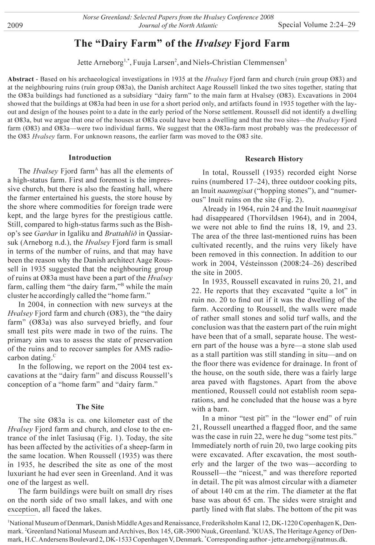
Figure 2. Aage Roussell’s survey plan from 1935. Ruin 17: ca. 10 m long and 4 m wide. Inside measurements. The house gable
towards the fjord is open. Roussell identifi es the ruin as a boathouse. Ruin 18: ca. 11 m long and 6.5 m wide. Roussell describes
the ruin as very indistinct. Not found again in 2004. Ruin 19: ca. 7 m long and 5 m wide. Not found again in 2004. Ruin 20: ca.
50 m long and 6 m wide. Exterior measurements. The eastern part of the ruin may represent a small separate square building.
The western part of the building was a byre with a stall partition of stone still standing and signs of a drain in the fl oor. Ruin 21:
ca. 18 m long and 5.5 m wide. Rather indistinct. Possibly more than one room. In 2004 a cultivated fi eld touches the southwest
corner of the building. Ruin 22: ca. 20 m long and 5 m wide. Exterior measurements. Three rooms. Test excavations revealed
fl agged fl oors. Ruin 23: ca. 11 m long and 5 m wide. Two rooms. Ruin 24: ca. 15 m long and 13 m wide. Exterior measurements.
A pen/enclosure, probably with a small building inside it. Situated in grassy meadow. Not found again in 1964. Just north of
ruin 20 there were two pits identifi ed by Roussell as cooking pits. Southwest of ruin 24 was an Inuit naanngisat 24 m long with
26 stones still in situ and distinct marks after another 14 stones. Not found again in 1964.
2009 J. Arneborg, F. Larsen, and N.-C. Clemmensen 27
fl agged and seems to have been rather narrow. The distance
between the two walls was only about 2 m.
In summary, even though nothing was left of
the interior, our profi le in ruin 20 showed that the
house has one construction phase only and the same
applies to ruin 22. There were no indications of the
houses having been in use for long.
Dating
Apart from tiny pieces of charcoal—insuffi cient
for AMS-dating—we unfortunately did not recover
anything in our trenches which could be used for
dating. We therefore have to pin down the date of the
site on the basis of the layout and state of the buildings
and the archaeological fi nds from 1935.
The houses at Ø83a all belong to the group that
Roussell classifi ed as “the long-house” and which he
dated to the fi rst period of settlement in Greenland
(Roussell 1941:202ff.). In spite of deserved criticism
of his house typology (Albrethsen 1982; Andreasen
1981), Roussell’s dating of this specifi c group of
buildings still stands, and since Roussell brought
forward his typology, at least two new houses—the
dwelling at GUS and the dwelling at the so-called
landnam farm in Narsaq, ruin group Ø17a—can be
included in the group to give further evidence to the
early dating of the “long-house” (Albrethsen and
Ólafsson 1998, Arneborg et al. 1998, Vebæk 1993).
The construction of the walls of the Ø83a houses
is comparable to the Narsaq (Ø17a) dwelling. Here,
the sill consisted of a frame of stones with an inside
fi lling of soil and turf. On the sill were courses of “…
alternate layers of stone and turf.” (Vebæk 1993:14
and fi g. 9). The fl oors were partly covered with slabs
(Vebæk 1993:14–15). The Narsaq house is radiocarbon
dated within the period AD 885–1155 (± 1
s.d.). At GUS, the frame of walls was entirely of turf
with an inside fi lling of soil and turf fragments (Albrethsen
and Ólafsson 1998:19). The GUS house is
radiocarbon dated within the period AD 1020–1280
(±1 s.d.) (Arneborg et al. 1998:27).
Outdoor cooking pits are known from Viking
Age farms in Iceland (Fornleifastofnun Íslands
Annual Report 2005:28, 2006:34f; Hermanns-
Auðardóttir 1989:107). In Greenland, in addition
to Ø83a, a large (5 m diameter, 2 m depth) outdoor
cooking pit has been recorded at the bishop’s farm
Gardar in Igaliku. The cooking pit is located in one
of the large enclosures of the farm and is impossible
to date (Nørlund 1929:89).
Among the artifacts from 1935, the line sinker
also points to an early date. The Narsarsuaq line
sinker cannot be dated. However, having been found
in the hall, the Brattahlið sinker may very well
belong to the early settlement period (Arneborg,
Saga trails: 25). Among others, at Jarlshof, Shetland
several comparable sandstone weights have been
found in one of the houses assigned to the Viking
Age (Hamilton 1956:160, 182; Steane and Foreman
1988:152), and at Bornais, Outer Hebrides, stone
weights have been found in an early 11th-century
house (Sharples 2004:267). In Iceland, a line sinker
of lava was found in the Ísleifsstaðir hall (Stenberger
1943:168f), which Vésteinsson (2006:118) dates to
the mid- or late 10th century.
Having failed to identify a dwelling, Roussell
categorized the Ø83a site as a “dairy-farm” belonging
to the Hvalsey Fjord farm (Ø83). By using the
term “dairy-farm,” Roussell perhaps had in mind
a shieling or some sort of pasture/summer farm.
However, in Danish, he used the word “avlsgård”
(Roussell 1935), which implies that it was at Ø83a
Figure 3. Spindle whorl of soapstone found 1935 at ruin
site Ø83a. Diameter: 3.9 cm. Photograph © National Museum
of Denmark.
Figure 4. Line sinker of soapstone found 1935 at ruin site
Ø83a. Length: 13.9 cm. Photograph © National Museum
of Denmark.
28 Journal of the North Atlantic Special Volume 2
that the actual farming took place, away from the
living quarters and main buildings at the Hvalsey
farm (Ø83). This assumption is at least partly contradicted
by the byres, stables, and barns at the Hvalsey
farm (Ø83) Roussell himself described.
Vésteinsson (2008:25) suggests that the large ruin
20 at Ø83a may have included both dwelling and stables.
In Norse Greenland, byres/stables/barns have not
been found in the same buildings as dwellings, but often
in separate buildings lying very close to each other
(e.g., Vebæk 1992:30, fi g. 31), and the same may have
been the case here. Roussell reported that the eastern
part of ruin 20 seemed to be that of a separate house,
though small. However, we agree with Vésteinsson
that due to the limited build-up of cultural deposits
and the poor preservation of organic materials, Roussell
most probably missed the dwelling of the farm.
“Dairy-farms” (i.e., avlsgårde) are not known from
other sites in Norse Greenland, and the size and number
of the houses, the cooking pits, and the presence
of a byre also point towards permanent habitation.
Therefore, despite the lack of conclusive evidence, the
possibility cannot be excluded that the ruins 21 and/or
22 also may have been dwellings. Consequently, the
Ø83a farm should be considered no less a farm than
other Greenlandic farms.
By linking the two sites Ø83 and Ø83a, Roussell
implicitly claimed that they had functioned at
the same time. The archaeological excavations,
however, show that the Ø83a-site was short-lived
and that it most probably belongs to the early period
of settlement, in contrast to the Hvalsey Fjord farm
(Ø83), where the recorded ruins seem to belong to
fi nal period of settlement (e.g., Roussell 1941:240f).
Still, the question remains about the relationship
between the two sites. Right now, we have no indications
about when the farm at Hvalsey Fjord
(Ø83) was established. Both sites may have been
settled in the landnám
period, with the Hvalsey
farm (Ø83) prospering at
the expense of the other
(Ø83a), leading to its
early abandonment. The
atypically close proximity
between the two sites,
however, suggests that
Vésteinsson is correct
when he proposes that
the Ø83a farm may have
been a precursor to the
Hvalsey Fjord farm Ø83
(Vésteinsson 2008:25),
and that the farm for yet
unknown reasons was
moved from the secluded
site on the inlet Tasiusaq
to the more prominent
and spectacular site at the
head of fjord nowadays
known as Qaqortup Imaa.
Conclusion
The plan of site
Ø83a, the layout of its
buildings, and the results
of minor archaeological
excavations there
in 1935 and 2004 suggest
that the site was
established in the early
period of Norse settlement
in Greenland and
for a rather short period
Figure 5. Ruin group Ø83a (inset; aerial image © 2009 Digital Globe) and survey plan 2004. only. Having failed to
Measured by N.-C. Clemmensen.
2009 J. Arneborg, F. Larsen, and N.-C. Clemmensen 29
identify a dwelling in his excavation in 1935, Aage
Roussell coupled the buildings at Ø83a with the
nearby Hvalsey Fjord farm (site Ø83), arguing that
the buildings at Ø83a were the economy buildings—
a dairy farm or avlsgård—of the “manor” at Ø83.
On presently available evidence, it is not possible
to establish the chronological connection between
the two sites, and we argue for the possibility that the
two sites constitute two independent farms that were
either established simultaneously in the early period
of settlement or—more probably—that the old farm
at Ø83a was the landnám farm and predecessor of
the later and better-known Hvalsey Fjord farm.
Acknowledgments
The excavations at Ø83a were initiated by the former
head of the Qaqortoq museum, now curator at the Greenland
National Museum and Archives in Nuuk, Georg
Nyegaard. The Commission for Scientifi c Research in
Greenland funded the excavations. Together with the authors,
undergraduate Christian Thomsen, Department of
Medieval and Renaissance Archaeology Aarhus University,
also participated in the archaeological investigations
at Ø83a. We all thank sheep farmer Kalistaaraq Karlsen
for his kind hospitality.
Literature Cited
Albrethsen, S.E. 1982. Træk af den norrøne gårds udvikling
på Grønland. Vestnordisk byggeskikk gjennom
to tusen år. AmS-Skrifter 7, Stavanger:269–287.
English summary.
Albrethsen, S.E., and G. Ólafsson. 1998. A viking age
hall. Pp. 19–26, In J. Arneborg and H.C. Gulløv (Eds.).
Man, Culture and Environment in Ancient Greenland.
The Danish National Museum and Danish Polar Center,
Copenhagen, Denmark.
Andreasen, C. 1981. Langhus - ganghus - centraliseret
gård. Hikuin 7, Århus:179–184.
Arneborg, J. n.d. Saga Trails. Nanortalik Museum, Narsaq
Museum, Qaqortoq Museum, and National Museum of
Denmark, Copenhagen, Denmark.
Arneborg, J., J. Heinemeier, N. Rud, and A. Sveinbjörnsdóttir.
1998. AMS dates from the hall (XVII). Pp.
27–30, In J. Arneborg and H.C. Gulløv (Eds.). Man,
Culture and Environment in Ancient Greenland. The
Danish National Museum and Danish Polar Center,
Copenhagen, Denmark.
Fornleifastofnun Íslands Annual Report. 2005. Reykjavík,
Iceland.
Fornleifastofnun Íslands Annual Report. 2006. Reykjavík,
Iceland.
Hamilton, J.R.C. 1956. Excavations at Jarlshof, Shetland.
Archaeological Report No. 1. Ministry of Works, Edinburgh,
Scotland, UK.
Hermanns-Auðardóttir, M. 1989. Islands Tidliga
Bosätning. Studia Archaeologica Universitatis Umensis
1. Umeå Universitet. Arkeologiska Institutionen,
Umeå, Sweden.
Nørlund, P. 1929. Norse Ruin at Gardar. Meddelelser om
Grønland Vol. LXXVI. Copenhagen, Denmark.
Roussell, Aa. 1935. Hvalsey, avlsgaarden, 1. Unpublished
report in the archives Antikvarisk-Topografi sk Arkiv.
National Museum of Denmark, Copenhagen, Denmark.
Roussell, Aa. 1941. Farms and Churches in the Medieval
Norse Settlements of Greenland. Meddelelser om
Grønland vol. 89(1). Copenhagen, Denmark.
Sharples, N. 2004. A fi nd of Ringerike art from Bornais
in the Outer Hebrides. Pp. 255–272, In Hines, J., A.
Lane, and M. Redknap (Eds.). Land, Sea, and Home.
Society for Medieval Archaeology Monograph 20.
Steane, J.M., and M. Foreman. 1988. Medieval fi shing
tackle. Pp. 137–186, In M. Aston (Ed.). Medieval Fish,
Fisheries, and Fishponds in England. BAR British
Series 182(i).
Stenberger, M. 1943. Ísleifsstaðir, Borgarfjarðarsýsla. Pp.
145–170, In M. Stenberger (Ed.). Forntida Gårdar i
Island. Munksgaard, Copenhagen, Denmark.
Thorvildsen, K. 1964. Grønlandsrejse 24/6–8/8 1964.
Diary in the archives Antikvarisk-Topografi sk Arkiv.
National Museum of Denmark, Copenhagen, Denmark.
Vebæk, C.L. 1991a. The Church Topography of the
Eastern Settlement and the Benedictine Convent in
Uunartoq Fjord. Meddelelser om Grønland—Man and
Society 14. Copenhagen, Denmark.
Vebæk, C.L. 1991b. Hunting on land and at sea and
fi shing in Medieval Norse Greenland. Acta Borealia
1-1991:5–14
Vebæk, C.L. 1992. Vatnahverfi . An inland district of the
Eastern Settlement in Greenland. Meddelelser om Grønland—
Man and Society 17, Copenhagen, Denmark.
Vebæk, C.L. 1993, Narsaq: A Norse landnáma farm.
Meddelser om Grønland. Man and Society 18, Copenhagen,
Denmark.
Vésteinsson, O. 2006. The Building and its context. Reykjavík
871 ± 2. Landnámssýningin. The Settlement
Exhibition. Reykjavík City Museum:116–121
Vésteinsson, O. 2008. Archaeological investigations in
Hvalseyjarfjörður, Eystribyggð 2005. Fornleifastofnun
Ìslands. FS388-0501. Reykjavík, Iceland
Endnotes
ADanish National Museum system ruin group Ø83,
Greenland National Museum and Archives system ancient
monument site 60V2-IV-646.
BDanish National Museum system ruin group Ø83a,
Greenland National Museum and Archives system ancient
monument site 60V2-IV-645.
CGreenland National Museum and Archives fi le no. KNK
2675.
DNational Museum of Denmark inventory no. D12691.1-5.
EFuuja Larsen, The Greenland National Museum and Archives
was the head of the excavations.