2012 J. Arneborg, N. Lynnerup, J. Heinemeier, J. Møhl, N. Rud, and Á.E. Sveinbjörnsdóttir 1
Introduction
You are what you eat—this saying covers mankind’s
relationship with daily food in more ways than one.
Diet and food systems reflect human exploitation of,
and attitude towards, the surrounding environment
and are bound up with resource utilization and the
subsistence economy. The subject involves factors
such as production, farming and hunting practices,
distribution, and consumption and it reflects social
relations linking humans together. Human food—
individual meals and food consumption over longer
periods—can, to a certain extent, be reconstructed on
the basis of archaeological evidence such as kitchen
lay-out, kitchen equipment and tableware, agricultural
and hunting equipment, animal bones deposited
on house floors, and refuse deposits outside.
Evidence from studies of pollen and macro-remains
of plants that have contributed to the diet provides
further information. The most direct evidence for the
reconstruction of past diets is, however, provided
by humans themselves. Through isotope analysis of
bone collagen, it is possible to gain an insight into
the food consumption of individual populations over
long periods of time.
Owing to the ethnic and cultural homogeneous
population and the relatively well-preserved bones
of both humans and animals, wild and domesticated,
the Norse settlements in South Greenland are particularly
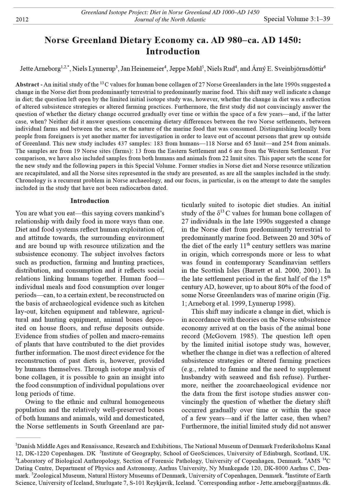
suited to isotopic diet studies. An initial
study of the δ13 C values for human bone collagen of
27 individuals in the late 1990s suggested a change
in the Norse diet from predominantly terrestrial to
predominantly marine food. Between 20 and 30% of
the diet of the early 11th century settlers was marine
in origin, which corresponds more or less to what
was found in contemporary Scandinavian settlers
in the Scottish Isles (Barrett et al. 2000, 2001). In
the late settlement period in the first half of the 15th
century AD, however, up to about 80% of the food of
some Norse Greenlanders was of marine origin (Fig.
1; Arneborg et al. 1999, Lynnerup 1998).
This shift may indicate a change in diet, which is
in accordance with theories on the Norse subsistence
economy arrived at on the basis of the animal bone
record (McGovern 1985). The question left open
by the limited initial isotope study was, however,
whether the change in diet was a reflection of altered
subsistence strategies or altered farming practices
(e.g., related to famine and the need to supplement
husbandry with seaweed and fish refuse). Furthermore,
neither the zooarchaeological evidence nor
the data from the first isotope studies answer convincingly
the question of whether the dietary shift
occurred gradually over time or within the space
of a few years—and if the latter case, then when?
Furthermore, the initial limited study did not answer
Norse Greenland Dietary Economy ca. AD 980–ca. AD 1450:
Introduction
Jette Arneborg1,2,*, Niels Lynnerup3, Jan Heinemeier4, Jeppe Møhl5, Niels Rud4, and Árný E. Sveinbjörnsdóttir6
Abstract - An initial study of the 13 C values for human bone collagen of 27 Norse Greenlanders in the late 1990s suggested a
change in the Norse diet from predominantly terrestrial to predominantly marine food. This shift may well indicate a change
in diet; the question left open by the limited initial isotope study was, however, whether the change in diet was a reflection
of altered subsistence strategies or altered farming practices. Furthermore, the first study did not convincingly answer the
question of whether the dietary change occurred gradually over time or within the space of a few years—and, if the latter
case, when? Neither did it answer questions concerning dietary differences between the two Norse settlements, between
individual farms and between the sexes, or the nature of the marine food that was consumed. Distinguishing locally born
people from foreigners is yet another matter for investigation in order to leave out of account persons that grew up outside
of Greenland. This new study includes 437 samples: 183 from humans—118 Norse and 65 Inuit—and 254 from animals.
The samples are from 19 Norse sites (farms): 13 from the Eastern Settlement and 6 are from the Western Settlement. For
comparison, we have also included samples from both humans and animals from 22 Inuit sites. This paper sets the scene for
the new study and the following papers in this Special Volume. Former studies in Norse diet and Norse resource utilization
are recapitulated, and all the Norse sites represented in the study are presented, as are all the samples included in the study.
Chronology is a recurrent problem in Norse archaeology, and our focus, in particular, is on the attempt to date the samples
included in the study that have not been radiocarbon dated.
Special Volume 3:1–39
Greenland Isotope Project: Diet in Norse Greenland AD 1000–AD 1450
Journal of the North Atlantic
1Danish Middle Ages and Renaissance, Research and Exhibitions, The National Museum of Denmark Frederiksholms Kanal
12, DK-1220 Copenhagen. DK 2Institute of Geography, School of GeoSciences, University of Edinburgh, Scotland, UK.
3Laboratory of Biological Anthropology, Section of Forensic Pathology, University of Copenhagen, Denmark. 4AMS 14C
Dating Centre, Department of Physics and Astronomy, Aarhus University, Ny Munkegade 120, DK-8000 Aarhus C, Denmark.
5Zoological Museum, Natural History Museums of Denmark, University of Copenhagen, Denmark. 6Institute of Earth
Science, University of Iceland, Sturlugate 7, S-101 Reykjavík, Iceland. *Corresponding author - Jette.arneborg@natmus.dk.
2012
2 Journal of the North Atlantic Special Volume 3
questions concerning dietary differences between
the two settlements, between individual farms, and
between the sexes, or the nature of the marine food
consumed. Distinguishing locally born people from
foreigners (immigrants?) is yet another matter for
study in order to leave out of account persons that
grew up outside of Greenland.
To a certain degree, the past diet (i.e., consumption
in a long-term perspective) of the Norse
Greenland settlers has been discussed for years on
the basis of the zooarchaeological record (McGovern
1985). Through stable isotope analysis (δ13 C
and δ15 N) of all the suitable Norse human remains
in the collections of the Anthropological Laboratory
at the Panum Institute in Copenhagen1, and
selected bone samples from all the animals represented
at Norse farms2, we aim to obtain an even
closer picture of the dietary economy of the Norse
Greenlanders to study the living conditions of the
Norse settlers in a long time perspective.
At the individual level, we want to explore what
kind of food was consumed and whether the longterm
dietary economy patterns contribute to the
discussion of the depopulation of the Norse Greenland
settlement in the second half of the 15th century.
The Norse Settlements of Southern Greenland
The Norse colonists arrived in Southwest Greenland
at the end of the 10th century. The settlement
consisted of individual farms concentrated in two
main areas (Fig. 2). The Eastern Settlement—including
the so-called Middle Settlement—extended
from the Cape Farewell region in the south to Tissaluup
Ilua in Sermesoq municipality in the north. The
smaller and more northerly Western Settlement was
situated in the Nuuk hinterland around the Nuuk and
the Ameralik-Ameralla fjords.
To date, about 560 Norse sites have been recorded
in the Eastern Settlement and around 75 in
the Western Settlement (Fig. 3; National Museum
of Greenland, Ancient Monuments Register). Even
though is it evident that not all the sites were independent
economic units (see for instance Albrethsen
and Arneborg 2004), not all the farms could have
been occupied at the same time, given the assumed
size of the population. Lynnerup (1998:100ff.) has
estimated the total number of inhabitants over time
in the two Norse settlements as about 26,000, and
with about 2000 at the peak of settlement around
1250. With an average of about 10 individuals per
farm during the peak period, a total of about 200
farms must have been occupied.
The last written evidence from the Eastern
Settlement is the account of a wedding that took
Figure 1. The results of the first isotope study on Norse
Greenland human remains.
Figure 2. The Norse settlements in Greenland were concentrated
in two main areas. The Eastern settlement between
60° and 61°N, and the Western Settlement around 64°N.
2012 J. Arneborg, N. Lynnerup, J. Heinemeier, J. Møhl, N. Rud, and Á.E. Sveinbjörnsdóttir 3
Figure 3. The Norse settlement. Each marking represents a Norse site. Each site holds between one and 60 individual ruins.
Østerbygden = the Eastern Settlement. Mellembygden is a modern name for the concentration of ruins south of Tissallup Ilua
and is regarded part of the medieval Eastern Settlement. Vesterbygden = the Western Settlement. Map after Arneborg (2004).
4 Journal of the North Atlantic Special Volume 3
place in Hvalsey fjord church in 1408, and AMSdates
for garments found in graves at the Herjolfsnes
(Ikigaat) churchyard indicate that life in the Eastern
Settlement continued at least until the middle of the
15th century (Arneborg 1996).
Radiocarbon dates indicate that the Western
Settlement was settled a little later than the Eastern
Settlement and, on the basis of Ívar Bárðarson´s
description of Greenland, the abandonment of the
Western Settlement has traditionally been dated to
the middle of the 14th century. However, by 1982,
the conventional radiocarbon dating of human remains
from the high-status farm Anavik challenged
the traditional dates. These findings indicated that
life in the Western Settlement continued until about
1400 (Table 15), and one3 AMS-date (AAR-1144;
Project ID 002 from Sandnes, see Table 12), included
in this study, and dates (see Table 14) from the Farm
Beneath the Sand (referred to from now on as GUS)
support a later date—around 1400—for the depopulation
of the Western Settlement than was previously
believed.
The reasons for the depopulation of the Norse
settlements in Greenland are not yet fully understood,
and many theories concerning the fate of the
Norse have been put forward over the years. Recent
research has concentrated, in particular, on the
interaction between humans and the environment,
exploitation of resources and economic strategies
and, specifically, the consequences of the climatic
changes that occurred during the Late Middle Ages,
and theories about maladaptation, overuse of the
natural resources, and, lately, the lack of resilience
have been put forward (Diamond 2005, Keller et al
2009, McGovern 2000). Also theories about failing
contacts with Northern Europe and a subsequent
shortage of vital imports have been suggested
as part of an explanation (e.g., Arneborg 2003,
2004:275ff.)
The Natural Setting
Greenland has an Arctic climate in that the average
temperature for the warmest month is less than
+10 ºC. In a few places in southwestern Greenland,
the average temperature can exceed +10 ºC, which
marks the boundary for the northern temperate (boreal)
region (Bay 2000:40). The climate along the
outer coast is markedly oceanic, but as one moves
inland from the coast towards the ice cap, the climate
becomes more continental with greater extremes of
temperature and lower precipitation. Temperatures
recorded in Igaliku, in the central Norse Eastern
Settlement, and in Kapisillit, situated centrally in the
Norse Western Settlement, reveal that the climate in
the former Western Settlement today is more continental
than in the central parts of the former Eastern
Settlement. The difference between these two inland
areas is particularly striking in the winter, when it
is considerably colder in the Western Settlement.
Similarly, the growing season there is much shorter
and with less precipitation (Krogh 1982:168–169).
Analyses of ice cores from the Greenland ice cap
show that the Northern Hemisphere has experienced
several temperature changes through time (Dahl-
Jensen et al. 1998). The time of the Norse settlement
in Greenland was a period of relative warmth, which
was gradually succeeded by a colder regime. The
middle of the 14th century is reported as being the
coldest period in Greenland during the last thousand
years (Barlow 2001:101). δ18 O isotopic climate
signals in the ice cores also indicate variations in
precipitation, with changes from a generally humid
regime during the landnam period (ca. 1004–1075)
to dry and very dry periods in the following centuries.
The 14th century was dry and cold (Andersen et
al. 2006).
Biostratigraphic diatom, foraminifera, and dinofl
agellate cyst analyses of two sediment cores
from Igaliku fjord in the center of the Norse Eastern
Settlement provide palaeoenvironmental evidence
revealing the nature of the climate at the time of
settlement. It was relatively mild and moist, which
is in agreement with the climate signals in the ice
cores mentioned above, and with little sea ice. During
the 11th century, cooling events occurred and
sea ice increased during cold seasons. From the 13th
century onwards, the colder climate persisted, summer
temperatures fell, and the sea ice in the fjords
increased. Simultaneously, wind activity increased,
culminating in the mid-14th century (Jensen et al.
2004, Kuijpers et al 1999, Lassen et al. 2004, Roncaglia
and Kuijper 2004).
The Economic Landscape
The individual Norse sites were scattered along
the fjords, along rivers, and by lakes where the surroundings
were suitable for pastures and hayfields.
The settlement pattern and the layout of the farm
buildings both show the importance placed on animal
husbandry. In Norse times, these sites all had names
which are now forgotten. A few Norse place names
have survived in the written sources, and many attempts
have been made to identify these sites (Jónsson
1930). In this publication, Norse place names
such as Brattahlid, Gardar, and Herjolfsnes, which
have become more or less conventions, will be used
on equal terms with the modern Greenlandic names.
Of the ca. 560 recorded sites/ruin groups, data
of mixed quality are available on ca. 488. About
20% of the recorded ruin groups consist of a single
structure and, of these, more than 50% lack dwelling
houses. In general, single-ruin sites consist of
2012 J. Arneborg, N. Lynnerup, J. Heinemeier, J. Møhl, N. Rud, and Á.E. Sveinbjörnsdóttir 5
various kinds of enclosures, pens, shelters for the
free-range livestock, and storehouses belonging to
nearby farms. A few, especially in the Western Settlement,
are centralized farms with living quarters
and economic functions, built close together in one
large block (Roussell 1941:159ff.).
A large number of sites (n = 169) consist of
between two and five ruins and, of these, 21% are
enclosures, animal shelters, and storehouses.
The majority of the Norse sites comprise between
six and 15 individual ruins, whereas a few farms in
the Eastern Settlement comprise between 16 and 45
ruins. These ruins are of dwelling houses, stables,
byres, barns, and various kinds of workshops. Turfand
stone-built walls surrounded a few sites, and an
even smaller number also had artificial irrigation
systems (Arneborg 2005). These findings all indicate
that animal husbandry was based on a combination
of “rough grazing” and more intensive management
with cultivation and storage of fodder and housing
of livestock during the winter. Whether the different
practices are based on chronology is unknown.
The terminology applied to farm structures in
Norse Greenland is a little muddled. This lack of
clarity is partly due to the fact that, in the literature,
Danish researchers mostly use the term farm
to refer to the farm buildings and yard linked with
the buildings, whereas, according to Ingvild Øye
(2005a:360f.), the Norwegian and North Atlantic
concept of a farm refers to an entire resource territory,
buildings included. In this respect, a farm could
be divided into several holdings or households with
temporary farms/shielings or annex farms (extended
households) close to specific resources such as pastures
and fishing waters, or they could contain tenant
farms with separate households.
In Greenland, the Brattahlid plain may be an example
of a farm with more than one household, having
had at least two dwelling houses, one at the North
Farm (Ø29a) and another at the River Farm (Ø29)
(Arneborg 2006:14ff.). In the mountains just above
the Brattahlid plain is yet another group of buildings
(site Ø29b), which most probably represents a
shieling site (Arneborg 2006:41f.). Without written
evidence, one can, however, only suggest boundaries
and probable relationships between sites. In the following,
the term farm will be used to refer to groups
of ruins (ruin sites) containing one or more buildings
regarded as living quarters (i.e., buildings of stone
and turf and with a midden in front)—though we are
well aware that the number of farms (economically
interrelated units) may become far too high, because
a farm in the North Atlantic sense may include several
households with several living quarters.
According to Norse concepts, the inhabited
and cultivated area of the farm was the bær, and the
nucleus of that area (the farmyard) was the tun. The
tun and the bær belonged to the infield, innan garðr,
which in some cases was surrounded by a fence,
garðr. In Iceland the tun is identical with the home
field, innan garðr (Øye 2005a:369, note 5). The
area outside the garðr was the outfield, utan garðr.
The infield-outfield system originated from a mixed
farming tradition that included both agriculture and
animal husbandry (Øye 2001:402). In the following,
the terms infield/home field and outfield will be used
in full knowledge of the fact that the borders between
the two often are difficult to establish since most
farms in Greenland lack fences around the home field.
The system of utilizing the resources of mountainous
and/or remote areas—the outfield or utan
garðr—was an integrated part of the Norse economic
strategies known in Western Norway from
the 2nd century onwards (Arge 2005; Benediktsson
1982; Mahler 1991, 2007; Øye 2005a:402ff.; Skrede
2005). The vegetation of the shieling sites was of
crucial importance. People set out for the shieling either
to cut grass and bring it back as hay to the barns
of the main farm/holding, or to take their livestock
to the shieling in early summer and stay there as a
long as the grazing was good (e.g., Øye 2005b:12).
In the first case, the shieling site only required a few
dwelling houses, and in the latter, enclosures and
buildings for dairy production were also necessary.
In Greenland, besides the mountain farm above the
Brattahlid farm in Qassiarsuk, a number of small
sites in the mountains of the Qorlortoq valley, just
north of Qassiarsuk, have been identified as shielings
belonging to the farms/holdings in the lowlands
of the same valley, and both types of shieling activities
have been proposed (Albrethsen 1991, Albrethsen
and Keller 1986).
Enclosures in the outfield had several functions
(Madsen 2007). For instance, the livestock could
be collected here every night for milking, or sheep
could be gathered once a year for shearing. In modern
times, Icelandic shepherds rounded up the sheep
in the evening. The animals then spent the night in
the enclosures, before being milked the following
morning and then driven back to the pastures (Bruun
1928:262).
The interior close to the ice is reindeer (Rangifer
tarandus) land, and hunting drives recorded in
the Western Settlement upland may reflect Norse
reindeer hunting (Christensen 1989:20ff.). Today,
reindeer are only present in the Norse Western
Settlement; they became extinct in the former Norse
Eastern Settlement during the 19th century (Meldgaard
1986:10–11).
A few solitary stone houses recorded on the outer
coast reflect Norse sea hunting (Berglund 1973).
Most probably they were used for storage of both the
catch and the hunting equipment.
6 Journal of the North Atlantic Special Volume 3
(The King’s Mirror) (KS 1926), from the middle of
the 13th century, records that the Greenlanders had
large farms with good pastures and plenty of cattle
and sheep. A few rich farmers even experimented
with growing grain, but most people did not know
of bread. Instead, they subsisted on butter, cheese,
and meat from their animal husbandry, and they also
ate all kinds of wild animals such as reindeer, whale,
seal, and bear.
In 1276, in a letter from Pope Johannes XXI to
the Archbishop of Nidaros, it is said that the Greenlanders
subsisted on dairy produce and fish (Reg.
Norv II:158), and Pope Alexander VI states in a
letter from 1492 that in Greenland, “… people live
on dried fish and milk because of the lack of bread,
wine, and oil.”
According to the animal bone record (Bruun
1896:434–437; Degerbøl 1930, 1936, 1941; Enghoff
2003; McGovern 1985, 1992; McGovern et
al.1993, 1996; Møhl 1982), cattle, sheep, and goats
were the most important domesticates on the Norse
farms, and pigs were also present in small numbers
in the early period. Horse bones are also present
in the assemblages, though generally in very small
numbers. At GUS, the number of horse bones is
relatively large, and these represent entire skeletons.
Cut marks on some of the bones indicate that horses
were skinned (Enghoff 2003:75). As a food source,
horses were probably of negligible importance since
there were, in the Middle Ages, strong taboos and
even legislation against the consumption of horse
flesh (Egardt 1981).
Cattle were kept on all the farms regardless of
size. Even the farmer at the small Western Settlement
farm Niaquusat had a cow or two in his byre,
despite the site not being an obvious place for cattle
raising. At the medium-sized, late-phase GUS farm,
the byre had one or two stalls for cattle.
Cattle were most frequent in the Eastern Settlement,
whereas sheep and goats dominated in the
Western Settlement. (McGovern 1985:85). At both
settlements, cattle were kept for dairy production
(Enghoff 2003:87; McGovern 1985:103; McGovern
et al. 1993:63, 1996:110), whereas sheep and goats
seem to have been used for milk, meat, and wool
(Enghoff 2003:87, McGovern 1985:103).
Sea hunting formed an important part of the Norse
Greenlander’s economy, and the coastal archipelago
was rich in various kinds of birds (including guillemot,
auk, eider, and gulls), seals, and whales (Muus
et al. 1981). Non-migratory seals such as harbor seal
(Phoca vitulina), ringed seal (Phoca hispida), and
bearded seal (Erignathus barbatus) occur in the area.
The latter is, however, more frequent in the Western
Settlement area than in the Eastern Settlement area
(Muus et al. 1981). In spring and early summer, and
again in the autumn, migrating harp seals (Phoca
groenlandica) pass along the coast of Southwest
The Social Landscape
The Norse societies were traditionally stratified,
with the ownership of land as the key issue (Hastrup
1985:107ff., Øye 2005a:365). The landowners may
have exploited the land themselves or they may have
rented out larger or smaller plots of lands to tenants
for specific periods. In his Greenland description,
the Norwegian priest Ívar Bárðarson (Halldórsson
1978:133ff., Jónsson 1930) mentions that some
landowners held many farms, and tenants may have
run these.
Archaeologically, sites with churches and, in
some cases, also banqueting halls (cf. Berglund
1982) and warehouses (cf. Arneborg 2006) have
been identified as high-status farms. According to
the archaeological record, 16 Eastern Settlement
farms have associated churches. In the Western Settlement,
two farms have been recorded as having
an associated church4. Five of the 16 Eastern Settlement
farms seem only to have had their churches
during the first period of settlement, indicating a
progressive centralization of power in the society.
Simultaneously, the churches changed status from
having served family groups and their servants to
serving larger congregations.
In the middle of the 14th century, Ívar Bárðarson
mentions ten large landowners (all having farms
with churches) in the Eastern Settlement, with the
episcopal residence Gardar as the absolutely largest.
Two of the farms belonged—according to Ívar—to
the Norwegian king.
With their large churches, banqueting halls, and
warehouses, Gardar (Ø47, Igaliku), Hvalsey fjord
church (Ø83, Qaqortukulooq; not included in this
study), and Herjolfsnes (Ø111, Ikigaat) may have
comprised the social and economic centers of the
late settlement period, while Gardar (Ø47), with its
52 recorded structures, appears as the most outstanding
of all the farms in Norse Greenland.
Resource Utilization and Economy: Written
Accounts, the Animal Bone Record, Pollen, and
Plant Macro-remains
In the few available written accounts, the subsistence
economy of the Norse Greenlanders is
described as mixed, with animal husbandry and
pastoralism on the one hand and hunting and fishing
on the other. When the German monk Adam of
Bremen described the islands of the north in about
A.D. 1070, he knew very little of Greenland. Adam
states that the Greenlanders were Christians and that
their living conditions were like those of the Icelanders.
According to Adam, the Icelanders, and consequently
the Greenlanders, had no cereals and lived
solely by raising cattle (Adam of Bremen 1978). A
little less than 200 years later, the Konungs skuggsiá
2012 J. Arneborg, N. Lynnerup, J. Heinemeier, J. Møhl, N. Rud, and Á.E. Sveinbjörnsdóttir 7
the Norse Greenlanders fished at all. The apparent
lack of fish bones may well reflect the handling of refuse
or methods of fish preparation. For example, fish
could have been cleaned at the fishing grounds. The
majority of the bone assemblages derive from midden
deposits outside the farm buildings. It is possible
that dogs, foxes, or ravens may have eaten the fish
bones lying on these refuse dumps. In contrast, all
finds from GUS derive from inside the building complex
itself. Here, meticulous sieving of deposits from
the house floors resulted in the retrieval of relatively
large numbers of fish bones, and there is no doubt
that the Norse did exploit the rich fish resources for
dietary purposes. Sculpin (Myoxocephalus scorpius),
arctic char(Salvelinus alpinus), capelin (Mallotus
villosus), cod (Gadus morhua), three-spined
stickleback (Gasterosteus aculeatus), and halibut
(Reinhardtius hippoglossoides) are all represented in
the bone assemblages from GUS (Enghoff 2003:47
ff.). The bones from GUS also show that ptarmigan
were frequently caught, as were arctic hare—both
most probably for their meat (Enghoff 2003:87f.).
Archaeobotanical Studies
Archaeobotanical studies have never played an
important role in the analysis of Norse resource utilization,
and our knowledge of the Norse use of plants
and berries is virtually non-existent. Knud Krogh
(1982:103) reports on pollen of oats found in the turf
wall that surrounded the small 11th-century church at
Brattahlid, showing that the Norse Greenlanders, at
least in the first period of settlement, grew or tried to
grow cereals for either porridge or bread. At GUS in
the Western Settlement, a fragment of a quernstone
made of local material was found bordering an 11thcentury
fireplace. This find, quernstones from other
farms, and a single fragment of a baking plate—
unfortunately without provenance—confirm that the
Norse Greenlanders may have made bread, though
not the leavened bread made with yeast which is
mentioned in the King´s Mirror, but flat bread called
leiv (Norwegian). Leiv was made from flour kneaded
with water and baked in the hot ashes on flat baking
plates (Øye n.d:17).
Finds from the midden deposits at the Sandnes
farm in the Western Settlement indicate that the Norse
also exploited edible plants. For example, seeds of
crowberry (Empetrum) and mountain cranberry (Vaccinium)
were found in small heaps highly reminiscent
of human feces. Seeds and other macro-remains of
knotgrass (Polygonum), corn spurrey (Spergula) and
flax (Linum), which may also have played a role in the
human diet, were present in the midden deposits as
well (Fredskild and Humle 1991:77-80). In the midden
at Niaquusat in the Western Settlement, pollen
of flax and spurrey was found. Spurrey is not an
Greenland (Muus et al. 1981). With the thick drift ice,
the hooded seal (Cystophora cristata) is a frequent
guest in the Eastern Settlement region (Muus et al.
1981). Walrus (Odobenus rosmarus) has never been
common south of 66° N in Southwest Greenland. In
the 19th century, however, stragglers were reported
in the Norse areas (Born et al. 1994:6), and a small
population may even have been present in Nuuk
fjord when the Norse settlers arrived (Bruun 1907,
Degerbøl 1936:7). Cod is present all year round in the
deep waters along the outer coast and in the fjords,
and in spring, capelin enter the fjords to find breeding
grounds near the shore. During the late summer, arctic
char (Salvelinus alpinus) move up the streams near
the settlements to spawn in the lakes in the hinterland,
and can be caught at that time in extremely large numbers
(Muus et al. 1981).
Bones of seal and reindeer dominate the wild
faunal assemblages, but walrus and polar bear are
also present. Seal bones dominate all the assemblages
from both settlements. In the Eastern Settlement,
most of the bones are of harp and hooded seal,
whereas harp and harbor seal are most frequent at
the Western Settlement (Enghoff 2003:35ff.). Seal
bones are present regardless of whether the farm is
situated close to the coast or far inland. Sealskins
may have been export articles; the fact that entire
animals were taken to even the most remote and
isolated inland farms emphasizes their economic
importance (McGovern 1985:101).
Reindeer played a greater role in the Western Settlement
than in the Eastern Settlement (McGovern
1985:85). Reindeer hunting must have been primarily
undertaken for meat, as only selected parts of
the animal were brought back to the farms (ibid).
The bone frequencies indicate that reindeer was on
the menu far more often at inland farms than at those
near the coast (Table 5; ibid).
Walrus and polar bear were primarily hunted
north of the settlements. Most of the walrus bone
fragments found in the Eastern Settlement are of
maxillae, indicating that only the valuable tusks were
brought back to the settlement (Enghoff 2003:39;
McGovern1985). In contrast, meat-bearing bones
from all main skeletal parts are present in the GUS
assemblage and in other assemblages from the Western
Settlement (Enghoff 2003:39). This different distribution
pattern may reflect the presence of a walrus
colony in the Western Settlement area and suggests
that walrus meat may have formed part of the Norse
diet here, especially during the initial settlement period.
Polar bear is mainly represented in the bone assemblages
by phalanges and metapodials, indicating
that only the valuable bearskins were brought back
from hunting trips (McGovern 1985: 89).
Fish bones are very rare in the excavated assemblages,
which has given rise to a debate as to whether
8 Journal of the North Atlantic Special Volume 3
indigenous plant in Greenland, but is a common weed
of Northern European grain fields, and the plant may
have come to Greenland along with imported corn
(Sørensen 1982:302). Flax is represented by both pollen
and macro-remains and was most probably grown
locally. It may have served as either animal fodder
and/or for making linen.
Since the early contributions of Iversen (1934),
there has been a small but growing corpus of pollen-
analytical data from the Western and Eastern
Settlements (e.g., Buckland et al. 2009; Edwards et
al. 2008; Fredskild 1973, 1978, 1988; Schofield
et al. 2008). This data tends to be from sampling
sites within and adjacent to settlement areas, and
cannot be discussed further here.
The Dataset
The data for the present study come from 19
Norse sites, and, for comparison, we have also included
samples from both humans and animals from
22 Inuit sites. The Inuit samples will be dealt with in
separate part of this report.
The study includes 183 samples from human
bones; 118 Norse and 65 Inuit. 254 samples are
from animal bones. The following domesticates
are represented: cow (Bos taurus), goat (Capra
hircus), sheep (Ovis aries), pig (Sus scrofa), horse
(Equus caballus), and dog (Canis familaris). The
following game animals are represented: harp seal
(Phoca groenlandica), common/harbour seal (Phoca
vitulina), ringed seal (Phoca hispida), bearded seal
(Phoca barbata), hooded seal (Cystophora cristata),
walrus (Odobenus rosmarus), narwhal (Monodon
monoceros), whale (Balaena mysticetus and Monodon
monoceros5), reindeer (Rangifer tarandus),
musk ox (Ovibos moschatus), thick-billed murres
(Uria lomvia) and hare (Lepus articus).
The Norse Sites
Of the Norse sites, 13 are from the Eastern Settlement
and 6 are from the Western Settlement. The sites
are ranked into three groups on the basis of elements,
layout, and number of buildings (Table 1):
1. High-status farms with a church.
2. Medium-sized farms with six or more
buildings that are either dispersed or
built so close together that from the outside
they look like one large building (the
centralized farm).
3. Small farms with five or less, but more
than one, buildings.
Nine of the sites are classified as high-status farms
(Ø1, Ø23, Brattahlid Ø29a, Gardar Ø47, Ø66, Ø149,
Herjolfsnes Ø111, Sandnes V51, and Anavik V7).
This is clearly an over-representation, compared to
the fact that only 3% of all Norse Greenland sites belong
to this group. The predominance of high-status
sites are bound up with the many human samples
included in the study. Seven farms are considered as
medium-sized farms (GUS, Narsaq Ø17a, Qorlortoq
Ø34, Qorlortoq Ø35, Igaliku Ø48, VatnahverfiØ71,
and VatnahverfiØ167). Of these, one of the farms
from the Western Settlement is of the centralized type
(GUS). Three farms (Niaquusat V48, Nipaatsoq V54,
and Naajaat Kuaat V63) are centralized farms and
classified as small farms (Figs. 4A, B).
The samples have been selected on the basis of
three criteria:
1. The major dietary species are represented.
2. The Eastern and Western Settlements are
more or less equally represented.
3. The different farm layouts as described
above are represented.
Table 1. Social ranking of farms in the study on the basis of elements. Layout and number of buildings/ruins. The distinction between “parish”
churches and “family” churches is based on the dating of the church. Ø = Eastern Settlement, V = Western Settlement.
Ruin group ID Farm layout Number of ruins “Parish” church Early “family” church Farm size
Ø1 - Nuunataaq Dispersed 21 Yes High status
Ø17a - Narsaq Dispersed 13 Middle sized
Ø23 - Sillisit Dispersed 18 Yes High status
Ø29a - Brattahlid Dispersed 20 Yes Yes High status
Ø34 Dispersed 17 Middle sized
Ø35 Dispersed 12 Yes Middle sized
Ø47 - Gardar Dispersed 45 Yes High status
Ø48 Dispersed 11 Yes Middle sized
Ø66 Dispersed 27 Yes High status
Ø71N Dispersed 12 Middle sized
Ø111 - Herjolfsnes Dispersed 10 Yes High status
Ø149 Dispersed 21 Yes High status
Ø167 Dispersed 15 Middle sized
V7 - Anavik Dispersed 8 Yes High status
V48 - Niaquusat Centralised 2 Small
V51 - Sandnes Dispersed 7 Yes High status
V54 - Nipaatsoq Centralised 1 Small
V63 Centralised 2 Small (?)
GUS Centralised 1 Middle sized
2012 J. Arneborg, N. Lynnerup, J. Heinemeier, J. Møhl, N. Rud, and Á.E. Sveinbjörnsdóttir 9
Figure 4. The Eastern (A) and Western (B) Settlements, with the farms included in this study.
10 Journal of the North Atlantic Special Volume 3
I. Early period (ca. A.D. 980–ca. A.D. 1160)
II. Middle period (ca. A.D. 1160–ca. A.D. 1300)
III. Late period (ca. A.D. 1300–ca. A.D. 1450)
The Samples from the Eastern Settlement
The “Landnam Farm”, Narsaq Ø17a. The Narsaq
plain is one of the earliest settled areas of the
Eastern Settlement, and the ruins here (ruin group
Ø17 and Ø17a) may originally have constituted one
very large farm (Fig. 5).
At Ø17a, only the dwelling itself (ruin 4) has
been investigated archaeologically, first by C.L. Vebæk
(1993) and later by Hans Kapel (2003, unpubl.
report).6 Faunal remains (n = 1738) from the dwelling
indicate that the economy of the farm was based
on a combination of animal husbandry and seal
hunting. Sheep and goats dominated, but cattle were
also of some importance. Pigs were kept in small
numbers (McGovern, in Vebæk 1993). The dwelling
had two building phases and, on the basis of
the architecture, C.L. Vebæk dated the house to the
landnam period, and later radiocarbon dates were in
keeping with Vebæk’s archaeological dating (Vebæk
1993:73), as were AMS-dates obtained during this
study (Table 2).
All usable human bones were sampled. With
regard to the dietary species, in order to achieve
optimal results, specimens were, wherever possible,
selected according to the following criteria:
1. Degree of preservation.
2. Bone-wall thickness. Only bones with a
good solid bone wall were selected.
3. In order to avoid multiple samples from
single individuals, either the right or the
left side of individual species was chosen.
Chronology
Most of the archaeological investigations included
in the study are from the period before strategraphical
excavations were exercised and before the introduction
of radiocarbon dating; consequently, chronological
control on the samples was from the outset limited
and mostly not available at all. To compensate for the
missing dating, we have radiocarbon dated a large
number of samples and when possible, on the basis of
the old reports and new experiences, tried to evaluate
the old excavations with the purpose of establishing a
chronology. The evaluated samples were divided into
three parts (AU) within the time span of Norse settlement
in Greenland:
Figure 5. The ruins in Narsaq, ruin site Ø17a. The ruins represent what are left of a very large Norse farm. All our samples
are from ruin 4. Map after H. Kapel 2003.
2012 J. Arneborg, N. Lynnerup, J. Heinemeier, J. Møhl, N. Rud, and Á.E. Sveinbjörnsdóttir 11
tions.7 Nevertheless, some trends can be observed.
Among the domesticates, there is a predominance
of cattle bones, and the relatively large numbers
of seal remains indicate that seal hunting was also
an important part of the economy. Seal bones are,
overall, almost as numerous as remains of cattle
(McGovern 1985:111). The 2006–2007 excavations
confirm these earlier observations and accentuate the
importance of seal, which increased through time
(McGovern and Pálsdóttir 2007:36).
Six samples from Ø17a contribute to the project,
all from domesticated animals. They all derive from
the earliest occupation phase of the dwelling, ruin
4 (AU I). The samples are all from C.L. Vebæk´s
excavations (Table 2).
Brattahlid, Qassiarsuk, Ø29 & Ø29a. Another
landnam site is on the Qassiarsuk plain in Tunulliarfi
k Fjord. A total of 60 ruins are recorded on the
plain and are identified as the high-status farm Brattahlid,
where Erik the Red settled with his
family in the mid-AD 980s. The numerous
ruins include several dwellings, suggesting
that the site was a multiple farm with more
than one household (Fig. 6).
At Qassiarsuk, the northernmost farm
(ruin group Ø29a) is thought to have been
that of Erik the Red. The farm has an associated
church. During the earlier period, the
church was the small so-called “Tjodhildes
Church” (Fig. 6, ruin 59). Later, a larger
church replaced the “Tjodhildes Church”
(Fig. 6, ruin 1).
Major excavations at Qassiarsuk were
carried out in 1932 under the direction
of Poul Nørlund and Mårten Stenberger
(1934), concentrating on the later church,
the graveyard, and two dwelling structures
in ruin group Ø29a. More recently, “Tjodhildes
Church” was excavated between
1961–65 (for more about the ruins in Qassiarsuk,
see Arneborg [2006]), and trial
trenches were dug in the midden at Ø29a
in 2005 and 2006 (Edvardsson 2007).
Conditions for the preservation of organic
materials are relatively poor on these
well-drained moraine plains, and only a
few animal bones (n = 304) were collected
during the earlier archaeological investiga-
Table 2. Samples from Narsaq, Ø17a.
Reservoir
corrected Calibrated
Project 14C Age 14C Age intercept(s) δ13C (‰)
ID Museum ID Provenance Species (BP) (BP*) (1 sigma range) VPDB Lab ID AU
# 080 KNK D5/1992.572 Ruin 4, by water channel, Sus scrofa 1240 ± 30 1040 ± 30 995 -17.19 AAR-6107 I
lower cultural layer. Res.age: 0.45 (980–1020)
# 082 KNK D5/1991.573 Ruin 4, by water channel, Ovis aries 955 ± 30 1035–1145 -20.25 AAR-6108 I
lower cultural layer (1025–1155)
# 083 KNK D5/1991.574 Ruin 4, by water channel, Ovis aries I
lower cultural layer.
# 084 KNK D5/1991.575 Ruin 4, by water channel, Ovis aries 1140 ± 35 895–935 -20.16 AAR-6109 I
lower cultural layer (885–975)
# 085 KNK D5/1991.576 Ruin 4, by water channel, Ovis/Capra I
lower cultural layer.
# 086 KNK D5/1991.577 Ruin 4, by water channel, Ovis/Capra I
lower cultural layer.
Figure 6. Ruin sites Ø29a (to the north of the stream) and to the south
ruin site Ø29, Brattahlid, Qassiarsuk. Map after Krogh (1982).
12 Journal of the North Atlantic Special Volume 3
Except for one sample of cattle bone, all the samples
from Qassiarsuk included in this project derive
from human skeletons excavated in the graveyard at
“Tjodhildes church” in the 1960s (Fig. 7, Table 3).
The small “Tjodhildes Church” building consists
of thick turf walls that are presumed to have surrounded
an inner wooden construction. The building
had convex long sides typical of 11th-century Scan-
Figure 7. The graves in the church yard at Tjodhildes Church. Determination of sex: red = female, blue = male, green =
children, black = unknown sex. The samples included in the study are marked with project ID. Map after Krogh (1982).
2012 J. Arneborg, N. Lynnerup, J. Heinemeier, J. Møhl, N. Rud, and Á.E. Sveinbjörnsdóttir 13
dinavian architecture. The majority of the dead are
placed with their arms extended along the sides of
their body, or hands placed across their pelvis; this
is said to indicate a 11th- or 12th-century burial (Kieffer-
Olsen 1993:21ff., 73 ff.). Earlier AMS-dates
(Arneborg et al. 1999, Lynnerup 1998:table V), and
those carried out in association with this project support
the assumption that the church belongs to the
early settlement period (Table 3).
With some exceptions, the south side of the
church was reserved for men and the majority of the
women were buried on the north side, together with
a few men (Balslev Jørgensen 2001:88). According
to Balslev Jørgensen (2001:89) and Alexandersen
and Prætorius (2003:13), there were clear differences
with regard to both stature and the condition
of the teeth between people buried on the south and
north sides. These are interpreted as indicating social
inequalities in diet and workload. In the present
study, four samples are from the south side of the
church, four from the north side, and another two
samples are from the east side of the church.
A special feature of the graveyard is a mass grave
containing 13 adult men and two boys of 10 and 17
years of age, respectively. This grave was clearly
secondary; the bones of the skeletons did not lie in
situ, indicating that those interred had either been
moved to “Tjodhildes Church” from another (heathen?)
grave or they may have died far away, their
bones being subsequently brought to Brattahlid for
burial (Balslev Jørgensen 2001:96ff.). Alexandersen
and Prætorius (2003:14) suggest that those buried
in the mass grave were related to each other. Two
samples in the project are from this grave.
The human samples from “Tjodhildes Church”
belong to AU I and II.
Qorlortoq, Ø34. The ruins at Ø34 constitute a
medium-sized farm with 16 ruins (Fig. 8). The first
archaeological investigation at this site took place
in the late 1990s, when sections of the midden were
excavated under the leadership of Georg Nyegaard.8
Radiocarbon dates point to settlement from landnam
to at least 1300. The samples (Table 4) in this study
Table 3. The samples from “Tjodhildes Church”, Brattahlid, Qassiarsuk, Ø29a. DNM = Danish National Museum, KAL = The Anthropological
Laboratory, Panum Institute, Copenhagen University.
Reservoir Calibrated
Project corrected intercept(s) δ13C (‰)
ID Museum ID KAL ID Provenance Species 14C Age (BP) 14C Age (BP*) (1 sigma range) VPDB Lab ID AU
# 011 DNM CLA-2 CLA-2 “TjodhildeChurch” Human Norse 1155 ± 46 1000 ± 46 1020 (995–1043) -18,1 AAR-1267 I
churchyard, Marine
mass grave fraction: 0.341
# 012 DNM CLA-1 CLA-2 “Tjodhilde Church” Human Norse 1112 ± 51 930 ± 51 1065–1115 -17.5 AAR-1268 I
churchyard, Marine (1028–1171)
mass grave fraction: 0.412
# 016 DNM 74 1060x01 “Tjodhilde Church” Human Norse 980 ± 49 880 ± 49 1169 (1061–1222) -19.1 AAR-1272 I–II
churchyard, Marine
northwest fraction: 0.224
# 017 DNM 380 “Tjodhilde Church” Bos taurus 1040 ± 80 1011 (960–1040) -20.6 AAR-1273 I
churchyard
# 018 DNM 110 1180x01 “Tjodhilde Church” Human Norse 1229 ± 41 1100 ± 41 976 (894–996) -18.5 AAR-1275 I
churchyard, south Marine
fraction: 0.294
# 019 DNM 90 1789x01 “TjodhildeChurch” Human Norse 1025 ± 50 870 ± 50 1192 (1122–1228) -18.0 AAR-1276 I–II
churchyard, south Marine
fraction: 0.353
# 025 DNM 36 1041x01 “Tjodhilde Church” Human Norse 997 ± 51 890 ± 51 1165 (1046–1218) -19.0 AAR-1568 I–II
churchyard, east Marine
fraction: 0.235
# 026 DNM 41 1043x01 “Tjodhilde Church” Human Norse 985 ± 45 870 ± 45 1175 (1061–1226) -18.9 AAR-1569 I–II
churchyard, east Marine
fraction: 0.247
# 027 DNM 73 1059x01 “Tjodhilde Church” Human Norse 1092 ± 55 870 ± 55 1172 (1063–1227) -16.8 AAR-1570 I–II
churchyard, Marine
northwest fraction: 0.494
# 028 DNM 66 1054x01 “Tjodhilde Church” Human Norse 1225 ± 51 1070 ± 51 985 (909–1017) -18,0 AAR-1571 I
churchyard, north Marine
fraction: 0.353
# 165 DNM 86 1070x01 “Tjodhilde Church” Human Norse I–II
churchyard,south
# 187 DNM 2 1029x01 “Tjodhilde Church” Human Norse I–II
churchyard,
northeast.
# 189 DNM 120 1794x01 “Tjodhilde Church” Human Norse I–II
churchyard, south.
14 Journal of the North Atlantic Special Volume 3
Gardar at Igaliku, Ø47. The sheep-farming community
Igaliku, with the ruins of the Norse bishop’s
see Gardar, and Igaliku Kujalleq, with the Norse
farm Ø66, are situated on Igaliku fjord, neighboring
Tunulliarfik. Gardar was by far the largest farm
in the Norse settlements. The farm was built on the
vast lush plain at the head of the fjord within easy
access of both Tunulliarfik and Igaliku fjords. The
Greenland bishop lived here in the period from about
1200 to 1378, and the farm shows all the signs of
belonging to the small group of wealthy farms in
Greenland. Besides the church, the farm had a large
banqueting hall where the bishop and/or the farmer
could entertain their guests. With easy access to the
sea, there were several large stone-built warehouses
for commodities intended for the North European
market. The two byres had room for about 100 of
the prestigious cattle, yet another sign of wealth,
and an artificial irrigation system helped to optimize
the yield of the large enclosed infield (cf. Arneborg
2005, 2006).
A total of 45 scattered ruins have been recorded
on the site (Fig. 9), but the number of buildings
could originally have been considerably greater. The
site was re-occupied by permanently resident sheep
farmers in the second half of the 18th century, and
many ruins have been torn down and the building
materials re-used (For more information about the
ruins at Igaliku, see Arneborg [2006]).
The size of the byres, as well as the numbers of
cattle bones recovered from the midden deposits,
demonstrate that the economy of the farm relied
heavily on cattle breeding (McGovern 1985:112).
Pastures around Gardar are excellent. However,
here, as elsewhere, seal hunting was also of considerable
importance (McGovern 1985:112).
The samples from Gardar include both human
bones and bones of domesticates and game animals
(Table 5), and all except one (Table 5, # 152) originate
from Poul Nørlund’s excavations of the site in
1926 (Nørlund 1930). The human remains are from
burials within the northern chapel of the church, including
one of the Greenlandic bishops (Gardar I, #
22) (see Arneborg et al. 1999, Lynnerup 1998, Nørlund
1930:64ff.), a 30–35-year-old male (Gardar X,
#20), and an 18/20–35-year-old female (Gardar XI,
#21). AMS-dates assign the deceased to the 13th
century (Lynnerup 1998:table V). The bishop can
are from the midden excavations, and none of them
have been dated.
Figure 8. Ruin sites in the Qorlortoq valley. After Krogh
(1982).
Table 4. The samples from Qorloortoq valley, Ø34.
Project ID Museum ID Provenance Species
#Ø34-01 #Ø34-01 Midden Odobenus rosmarus
#Ø34-10 #Ø34-10 Midden Phoca groenlandica
#Ø34-56 #Ø34-56 Midden Monodon monoceros
#Ø34-64 #Ø34-64 Midden Rangifer tarandus
#Ø34-75 #Ø34-75 Midden Phoca groenlandica
#Ø34-77 #Ø34-77 Midden Phoca groenlandica
2012 J. Arneborg, N. Lynnerup, J. Heinemeier, J. Møhl, N. Rud, and Á.E. Sveinbjörnsdóttir 15
churchyard east of the church (Degerbøl 1930:183)
(Table 5), but were deposited in a midden prior to the
establishment of the churchyard (J. Arneborg, unpubl.
data). The walrus skulls belong to AU I.
Igaliku Kujalleq Ø66. The Norse farm Ø66 lies
alongside a minor inlet on the southeastern side of
Igaliku fjord. Today, the innermost part of the fjord
possibly be identified as Olaf, who—according to
written sources—was elected bishop in 1246 and
died in 1280/81 (Arneborg 1991).
Almost all of the animal samples in our study come
from bones that no longer have their original find
numbers, making it impossible to determine precisely
where they were found. A number of walrus skulls
(samples # 310–316) probably all come from the
Figure 9. Ruin site Ø47: the Episcopal residence Gardar, Igaliku. Map after Krogh (1982).
16 Journal of the North Atlantic Special Volume 3
Table 5. The samples from Gardar, Igaliku, Ø47.
Calibrated
Reservoir intercept δ13C
Project Museum 14C Age corrected (1 sigma (‰)
ID ID KAL ID Provenance Species (BP) 14C Age (BP*) range) VPDB Lab ID AU
# 020 DNM X 0915x01 Inside north chapel Male human Norse 1030 ± 65 810 ± 65 1233 -16.8 AAR-1437.1 II
of church, Marine (1170–1281)
below bishop fraction:
0.499
# 021 DNM XI 0916x01 Inside north chapel Female human Norse 880 ± 90 700 ± 90 1295 -17.6 AAR-1438-1 II–III
of church, Marine (1256–1392)
below bishop fraction:
0.254
# 022 DNM I 1118x01 Inside north chapel Human Norse 880 ± 55 770 ± 55 1272 -18.8 AAR-1439-1 II
of church - bishop Marine (1223–1290)
fraction:
0.612
# 149 DNM 70 Surroundings of Equus caballus
smithy, ruin 11, and
to the west of it
# 152 DNM Bos taurus
# 153 DNM Bos taurus
# 161 DNM Bos taurus
# 260 DNM Cystophora cristata
# 270 DNM Capra hircus
# 281 DNM Ovis aries
# 282 DNM Ovis aries
# 283 DNM Ovis aries
# 284 DNM Ovis aries
# 285 DNM Ovis aries
# 286 DNM Ovis aries
# 287 DNM Ovis aries
# 288 DNM Ovis aries
# 289 DNM Capra hircus
# 290 DNM Capra hircus
# 291 DNM Capra hircus
# 292 DNM Capra hircus
# 293 DNM Phoca hispida
# 294 DNM Phoca hispida
# 295 DNM Cystophora cristata
# 296 DNM Cystophora cristata
# 297 DNM Cystophora cristata
# 298 DNM Cystophora cristata
# 299 DNM Cystophora cristata
# 300 DNM Cystophora cristata
# 301 DNM Cystophora cristata
# 302 DNM Phoca barbata
# 303 DNM Phoca barbata
# 304 DNM Phoca barbata
# 306 DNM Canis familaris
# 308 DNM 76 In the great heaps Sus scrofa 1040 ± 45 835 ± 45 1215 -17.11 AAR-6138 II
east of the dwelling, Res. age: (1165–1260)
ruin 8 0.46 x 450 yeard,
marine model 1998
# 309 DNM 70 Surroundings of Sus scrofa 1130 ± 35 875 ± 35 1165 -16.15 AAR-6139 II
smithy, ruin 11, and (1075–1205)
to the west of it
# 310 DNM Churchyard, east of Odobenus rosmarus 1390 ± 30 940 ± 30 1050 -13.10 AAR-6140 I
the cathedral (1030–1070)
# 311 DNM Churchyard, east of Odobenus rosmarus
the cathedral
# 312 DNM Churchyard, east of Odobenus rosmarus 1430 ± 30 980 ± 30 1025 -12.73 AAR-6141 I
the cathedral (1005–1045)
# 313 DNM Churchyard, east of Odobenus rosmarus 1420 ± 35 970 ± 35 1030 -12.78 AAR-6142 I
the cathedral (1010–1050)
# 314 DNM Churchyard, east of Odobenus rosmarus I
the cathedral.
# 315 DNM Churchyard, east of Odobenus rosmarus I
the cathedral.
# 316 DNM Churchyard, east of Odobenus rosmarus I
the cathedral.
2012 J. Arneborg, N. Lynnerup, J. Heinemeier, J. Møhl, N. Rud, and Á.E. Sveinbjörnsdóttir 17
1883:113ff.), the assemblage of animal remains
from Ø66 comprises fewer than 100 individual
bones, and consequently no analysis of the economy
of the farm has ever been carried out.
In 1926, Aage Roussell (1926 unpubl. report)
dug a small test pit in the churchyard and brought
the remains of four skeletons back to Denmark. The
two samples from Ø66 included in this project were
collected from the churchyard by Roussell in 1926
(Table 6).
The church has a rectangular ground plan and is
dated to after 1300 (Roussell 1941:123ff.). Earlier
churches at the site have not been recorded. The
burials from which the samples came were in drift
sand deposited along the south side of the church after
the building was constructed; consequently they
should be later than 1300. Both samples have been
AMS-dated; one to the time around 1300, the other
one is dated broadly to the 14th century, most likely
the later part of the century, close to 1400.
Russip Kuua, VatnahverfiØ71. Farm Ø71 at
Russip Kuua and Ø167 ”Abel’s farm” are both
situated in Vatnahverfi. The ruins at farm Ø71 lie
is dry at low tide, and sediment cores show that
previously fertile areas of land now lie submerged
(Mikkelsen et al. 2008). The farm is situated on a
large, heavily vegetated plain on a route leading to
the large inland area of Vatnahverfi, which extends
over 500 km2. More than 20 ruins have been recorded
at Ø66; the farm has an associated church
and is regarded as one of the largest in the Eastern
Settlement (Fig. 10)
The Vatnahverfiregion was relatively densely
populated during the Norse period, and archaeologists
have reported erosion and sand drift from several
farms (e.g., Vebæk 1943:18ff., 55ff.). In 1894,
Daniel Bruun (1896:374ff) reported that many of
the ruins at Igaliku Kujalleq (Ø66) were covered by
sand, especially those lying to the east of the church.
The rooms of the dwelling house had filled up with
sand before the walls collapsed, indicating that sand
drift was already a problem when the house was
abandoned. The church seemed to have been raised
on a sand dune, and burials on the south side of the
church were cut down into the sand (Fig. 10B).
Despite several excavations during the years
(Bruun 1896:368ff., Clemmensen 1911, Holm
Figure 10a. Ruin site Ø66. A: Igaliku Kujalleq. Map after N.A. Møller and C.K. Madsen (2005), and B (following page):
church and dwelling. Map after Bruun (1896).
18 Journal of the North Atlantic Special Volume 3
Figure 10b. Ruin site Ø66: B. church and dwelling. Map after Bruun (1896).
2012 J. Arneborg, N. Lynnerup, J. Heinemeier, J. Møhl, N. Rud, and Á.E. Sveinbjörnsdóttir 19
In total, 19 ruins have been recorded at the site.
Of these, seven are situated on the south side of the
river and the remainder on the north side. Of the
many ruins, 11 were more or less excavated in 1949
by C.L. Vebæk (1992:23ff.). Seven ruins were investigated
on the north side of the river and four on the
south side (Fig. 11).
The three samples from Ø71 in this project are
from cattle bones; they all originate from the ruin
12, situated on the north side of the river (Fig.
11, Table 7). The house is of the long-house type
with a dwelling at one end and a byre/barn at the
other. The samples are from dwelling rooms II and
VI. The samples from room II are dated within the
period ca. 1000–1300. The sample from room VI is
dated to the 14th century.
in an open grassy area on both sides of a stream
connecting the two lakes of Saqqaata Tasia and
Skyggesø. Dwelling structures and byre/barn
complexes have been found on both sides of the
stream. Whether the two farms were occupied
simultaneously or not is unknown, although artefacts
from the two houses seem to support the idea
of contemporaneity, and we may be dealing with a
multiple farm with more than one household. The
site has not suffered from erosion or sand drift.
However, dental microwear studies on mandibles
from Ø71 south farm show that the sheep and
goats ingested high levels of soil and grit. This
phenomenon is associated with sparse or patchy
vegetation cover and is perhaps indicative of pasture
degradation (Mainland 2000).
Table 6. The samples from Igaliku Kujalleq, Ø66.
Reservoir Calibrated
Project 14C Age corrected intercept δ13C (‰)
ID Museum ID KAL ID Provenance Species (BP) 14C Age (BP*) (1 sigma range) VPDB Lab ID AU
# 023 DNM Gardar XII3 0919x01 Churchyard Human Norse 880 ± 55 610 ± 55 1392 -15.8 AAR-1441-1 III
Marine (1312–1417)
fraction: 0.612
# 024 DNM Gardar XII4 0920x01 Churchyard Human Norse 890 ± 45 690 ± 45 1297 -17.3 AAR-1442 II–III
Marine (1279–1317)
fraction: 0.441
Table 7. The samples from Vatnahverfi, Ø71.
Project 14C Age Calibrated intercept δ13C (‰)
ID Museum ID Provenance Species (BP) (1 sigma range) VPDB Lab ID AU
# 110 DNM D23/1991 Ruin 12, room 2 Bos taurus 735 ± 35 1280 (1265–1290) -20.14 AAR-6143 II
# 111 DNM D23/1991 Ruin 12, room 6 Bos taurus 700 ± 40 1290 (1280–1375) -20.39 AAR-6144 II–III
# 117 DNM D23/1991 Ruin 12, room 2 Bos taurus 965 ± 35 1030 (1020–1155) -19,54 AAR-6145 I
Figure 11. Ruin site Ø71. Map after Vebæk (1992).
20 Journal of the North Atlantic Special Volume 3
At Ø167, animal husbandry seems to have been of
slightly greater importance, and seal hunting correspondingly
less important, than at Ø71. As at all
other Norse farms, the harp seal is the dominant seal
species.
The composition of the faunal material from
Ø71 and the neighboring farm Ø167 (see below)
is almost identical (McGovern 1992:93ff.). About
20% of all bones are from cattle, ca. 40% are sheep/
goat, whilst the remaining ca. 40% are from seal.
Figure 12. The central ruins at Ø167. Map after Vebæk (1992).
2012 J. Arneborg, N. Lynnerup, J. Heinemeier, J. Møhl, N. Rud, and Á.E. Sveinbjörnsdóttir 21
“Abels gård”, VatnahverfiØ167. Further on in
Vatnahverfi, 3–4 km from Russip Kuua (Ø71), farm
Ø167 lies in a small mountain valley. The mediumsized
Ø167 farm was initially registered in 1948,
and archaeological excavations were conducted at
the site under the direction of C.L.Vebæk in 1949
(Vebæk 1992:45ff.). The ruin group comprises 15
ruins (Fig. 12), of which the following were studied:
The dwelling (ruin 1), ruin 2 (also a habitation
structure, possibly part of ruin 1), what is described
as the traces of an earlier building between ruin 1
and ruin 2 and also ruin 7, which must be regarded
as a centralized farm complex. The chronological
relationship between ruins 1 and 2 and the central
farm complex, ruin 7, is unclear. As at Ø71, the site
has not suffered from erosion or sand drift.
Fragments of a human skull were found in the
passage of the centralized farm ruin 7. The circumstances
of this strange deposition are unknown.
However, as only small parts of the skull were
found, it must lie in a secondary position. The skull
has been radiocarbon dated to around AD 1275
(Vebæk 1992:108).
A total of 23 samples (including bones of
domesticates as well as of seal) from Ø167 are
included in the project (Table 8). Apart from one
single stray find, and the one sample collected in
ruin 7 (the human skull), all samples come from
ruin 1, where they were either collected inside the
building in rooms I and II, III and IV, or V or from
the midden.
The ruins were not excavated stratigraphically,
and a glance at the excavation plan of ruin 1 (Fig. 13)
shows that the house, or at least the central part of
the building, has had more than one building phase.
Vebæk (1992:46ff.) points out that rooms 1a and
1b belong to an earlier phase. Rooms I and II at the
eastern end of the building were remarkably wellpreserved,
with fireplaces in niches in the wall. Artefacts
found in the room indicate a date after 1200;
we do, however, have radiocarbon dates that indicate
activities in the 11th century (AAR-6132). Room III
is in the central part of the building, and several
building phases were recorded here. The artefacts
from the room cannot be dated. With regard to room
V, Vebæk does not mention more than one phase.
Artefacts from this room are from the period after
1200. AMS-dates confirm that the house has several
phases, that the oldest parts are from the landnam
period, and that it is not possible to establish a secure
local chronology (Table 8).
Table 8. The samples from Vatnahverfi, Ø167.
Calibrated
Project 14C Age intercept(s) δ13C (‰)
ID Museum ID Provenance Species (BP) (1 sigma range) VPDB Lab ID AU
# 081 KNK D24/1991.290 Strayfind Sus scrofa
# 087 KNK D24/1991.291 House 7, passage Bos taurus
between room III and IV
# 088 KNK D24/1991.292 Midden, house 1 Cystophora cristata
# 089 KNK D24/1991.293 Midden, house 1 Cystophora cristata
# 090 KNK D24/1991.294 Midden, house 1 Cystophora cristata
# 091 KNK D24/1991.295 House 1, room III Bos taurus
# 092 KNK D24/1991.296 House 1, room III Bos taurus
# 093 KNK D24/1991.297 House 1, room III Bos taurus
# 094 KNK D24/1991.298 House 1, room III Bos taurus
# 095 KNK D24/1991.299 Midden, house 1 Ovis aries
# 108 KNK D24/1991 House 1, room III Bos taurus 940 ± 35 1040–1150 -20.02 AAR-6133 I
(1025–1160)
# 109 KNK D24/1991 House 1, room I and II Bos taurus 970 ± 40 1030 -20.45 AAR-6132 I
(1020–1155)
# 112 KNK D24/1991 Midden, house 1 Bos taurus
# 113 KNK D24/1991 House 1, room V Bos taurus 855 ± 40 1195–1210 -20.71 AAR-6136 II
(1160–1235)
# 114 KNK D24/1991 House 1, wall between Bos Taurus 675 ± 35 1295 -20.71 AAR-6137 III
room III and IV (1285–1380)
# 115 KNK D24/1991 House 1, wall between Bos taurus
room III and IV
# 116 KNK D24/1991 House 1, room III Bos taurus
# 118 KNK D24/1991 Midden, house 1 Bos taurus
# 119 KNK D24/1991 House 1, room V Bos taurus 780 ± 45 1265 -20.01 AAR-6135 II
(1220–1280)
# 120 KNK D24/1991 House 1, room III Bos taurus 1090 ± 30 980 -20.40 AAR-6134 I
(900–995)
# 121 KNK D24/1991 Midden, house 1 Cystophora cristata
# 122 KNK D24/1991 House 1, room I and II Phoca groenlandica
# 123 KNK D24/1991 House 1, room I and II Cystophora cristata
Ø167 Human skull 710 ± 50 1275 -19.1 K-5889 II
(1280–1305)
22 Journal of the North Atlantic Special Volume 3
Figure 13. The dwelling, ruin no. 1 at ruin site Ø167. Map after Vebæk (1992).
Figure 14. The ruin site Ø149, Narsarsuaq. Map after Vebæk (1992).
2012 J. Arneborg, N. Lynnerup, J. Heinemeier, J. Møhl, N. Rud, and Á.E. Sveinbjörnsdóttir 23
Narsarsuaq Ø149. The Norse farm Ø149 at
Narsarsuaq in Uunartoq Fjord was first identified
by Poul Nørlund and later accepted by C.L.Vebæk
as the Benedictine convent referred to by Bárðarson
(Halldórsson 1978:135, Jónsson 1930:23). The ruins
of the high-status farm lay spread across a large
plain, from where a total of 21 features, including
home-field dikes, have been recorded (Fig. 14).
Ø 149 is situated on a peninsula between Lichtenau
Fjord and Uunartoq Fjord in the less densely
inhabited southern region of the Norse Eastern Settlement
(Fig. 4A). The site lies close to the hot springs
on the island of Uunartoq. These springs may have
been one of the attractions and perhaps even formed
part of the economic basis of the farm. Iceland is well
known for its many hot springs, which were considered
to be curative (Sveinbjarnardóttir 2005).
The first archaeological excavations took place
in 1945-46 and again in 1948 under the direction of
C.L. Vebæk (1991). The following ruins were investigated
(Fig. 14): church and churchyard (ruin 1),
sections of the dwelling (ruin 2), the stable/barn
complex (ruin 9) and a small stable (ruin 7). Neither
the buildings, which resemble all other Norse farms,
Table 9. The samples from Narsarsuaq, Uunartoq, Ø149.
Reservoir Calibrated
Project Museum 14C Age corrected intercept(s) δ13C (‰)
ID ID KAL ID Provenance Species (BP) 14C Age (BP*) (1 sigma range) VPDB Lab ID AU
# 007 DNM I:7 1000x01 Churchyard, gravefield I Human Norse 845 ± 50 580 ± 50 1401 -15.9 AAR-1263 III
Marine (1329–1428)
fraction:
0.600
# 008 DNM I:10 1001x01 Churchyard, gravefield I Human Norse 937 ± 53 610 ± 53 1389 -14.8 AAR-1264 III
Marine (1312–1414)
fraction:
0.729
# 009 DNM II:1 1002x01 Churchyard, gravefield II Human Norse 886 ± 48 640 ± 48 1322 -16.3 AAR-1265 III
Marine (1301–1399)
fraction:
0.553
# 010 DNM I:6 0999x01 Churchyard, strayfind Human Norse 852 ± 44 590 ± 44 1399 -16.0 AAR-1266 III
Marine (1325–1418)
` fraction:
0.588
# 212 DNM I:2 0995x01 Churchyard, gravefield I Human Norse
# 213 DNM I:3 0996x01 Churchyard, gravefield I Human Norse 910 ± 35 605 ± 35 1340–1390 -15.24 AAR-6146 III
Res. age: (1320–1405)
0.68
# 214 DNM I:4 0997x01 Churchyard, gravefield I Human Norse 1005 ± 35 700 ± 35 1290 -15.27 AAR-6147 III
Res. age: (1280–1305)
0.67
# 215 DNM I:5 0998x01 Churchyard, gravefield I Human Norse 940 ± 35 665 ± 35 1305 -15.83 AAR-6148 III
Res. age: (1290–1325)
0.61
# 216 DNM I:6 0999x01 Churchyard, gravefield I Human Norse 1050 ± 40 710 ± 40 1290 -14.61 AAR-6149 III
Res. age: (1270–1305)
0.75
# 217 DNM I:7 1000x01 Churchyard, gravefield I Human Norse III
# 218 DNM I:10 1001x01 Churchyard, gravefield I Human Norse III
# 219 DNM II:1 1002x01 Churchyard, gravefield II Human Norse III
# 220 DNM II:3 1003x01 Churchyard, gravefield II Human Norse
# 221 DNM II:9 1009x01 Churchyard, gravefield II Human Norse
# 222 DNM II:4 1004x01 Churchyard, gravefield II Human Norse
# 223 DNM 1005x01 Churchyard Human Norse
# 224 DNM II:6 1006x01 Churchyard, gravefield II Human Norse
# 225 DNM 1007x01 Churchyard Human Norse
# 226 DNM II:8 1008x01 Churchyard, gravefield II Human Norse
# 227 DNM II:10 1010x01 Churchyard, gravefield II Human Norse
# 228 DNM II:11 1011x01 Churchyard, gravefield II Human Norse
# 229 DNM 1012x01 Churchyard, fence NE Human Norse
# 230 DNM 1014x01 Churchyard, fence NE Human Norse
# 231 DNM 1018x01 Churchyard, heap 1 Human Norse
# 232 DNM 1013x01 Churchyard, fence NE Human Norse
# 233 DNM 1022x01 Churchyard, heap 2 Human Norse
# 234 DNM 1021x01 Churchyard, heap 2 Human Norse
# 235 DNM 1017x01 Churchyard, strayfind Human Norse
# 236 DNM 1023x01 Churchyard, strayfind Human Norse
# 237 DNM 1141x01 Churchyard, strayfind Human Norse
24 Journal of the North Atlantic Special Volume 3
nor the artefacts recovered, provide any indications
that the farm at Narsarsuaq had any special function,
and none indicate that it served as a convent.
The faunal material is limited (n = 610). Seal
bones dominate, accounting for 61% of the total
bone assemblage. Domesticated animals make up
33% of the bones, with almost equal numbers of
cattle and sheep/goat remains (Vebæk 1991:71ff.).
Thirty samples from Ø149 are included in the
project (Table 9). All are from human burials within
the churchyard, including finds from two “grave
fields” I and II. The church is of the long house type
dated to after 1300. Older phases of the church have
not been recorded. According to Vebæk, grave field I
was excavated in two layers, whereas only the upper
layer of grave field II was excavated. Skeletons from
grave field I are dated to the 14th century. The youngest
is from about 1400. The skeletons from grave
field II are most probably from the same period.
Herjolfsnes at Ikigaat, Ø111. The farm at Herjolfsnes
(Ø111), with its church and well-built banqueting
hall, differs from the other high-status farms
with regard to location. The farm lies southernmost
in the Eastern Settlement on a peninsula that extends
directly out into the Atlantic Ocean ca. 50 km from
Cape Farewell (Fig. 4A). The vegetation is sparse,
although lush grass grows in sheltered spots in the
mountains. The ruins lie on a small promontory,
which is only sheltered from the Atlantic storms by
some small islands and rocky skerries; this is not a
typical location for a Norse farm. The number of recorded
structures at the site is 12 (Fig. 15). However,
due to both landslides and erosion, some ruins may
have been either buried or lost to the sea. Ruins may
also have been removed when a small trading post
was established here in 1834 (Nørlund 1924:15).
In the written sources, Herjolfsnes is bound up
with trade and the sea, and this may very well have
Figure 15. The ruin site Ø111, Herjolfsnes, Ikigaat. Map by N.-C. Clemmensen and H.C. Kapel (2008).
2012 J. Arneborg, N. Lynnerup, J. Heinemeier, J. Møhl, N. Rud, and Á.E. Sveinbjörnsdóttir 25
been the basis for the social position of the farm.
Herjolfsnes may have been the first place travellers
came to after having crossed the North Atlantic and
the last when they set sail (cf. Arneborg 2006).
Twelve ruins have been recorded at Herjolfsnes
(Fig. 15; Arneborg 2006:74ff.). Other than the
church, the ruin group comprises a dwelling, a supposed
stable/barn complex, a smithy, and outhouses.
The main excavations of the site took place in 1921
under the direction of Poul Nørlund (1924).
The Herjolfsnes church is of the Romanesque
type (Fig. 16), and radiocarbon dates for both cloth
Figure 16. The Church and churchyard at Ø111. After P. Nørlund (1921).
Table 10. The samples from Herjolfsnes, Ikigaat, Ø111.
Reservoir Calibrated
Project Museum 14C Age corrected intercept δ13C (‰)
ID ID KAL ID Provenance Species (BP) 14C Age (BP*) (1 sigma range) VPDB Lab ID AU
# 013 DNM 18 0906x01 Churchyard Human Norse 899 ± 84 550 ± 84 1418 (1329–1456) -14.4 AAR-1269 III
Res. age: 0.776
# 014 DNM 1 1105x01 Churchyard Human Norse 750 ± 56 500 ± 56 1437 (1413–1467) -16.2 AAR-1270 III
Res. age: 0.565
# 015 DNM 4 1106x01 Churchyard Human Norse 767 ± 45 520 ± 45 1430 (1407–1447) -16.3 AAR-1271 III
Res. age: 16.3
# 201 DNM 0903x01 Churchyard. Human Norse III
# 202 DNM 0905x01 Churchyard. Human Norse III
# 203 DNM 0907x01 Churchyard. Human Norse III
# 204 DNM 1108x01 Churchyard. Human Norse III
# 205 DNM 9 1110x01 Churchyard Human Norse 1000 ± 35 730 ± 35 1285 (1260–1295) -15.94 AAR-6127 II
Res. age: 0.60
# 206 DNM 11 1111x01 Churchyard Human Norse 960 ± 35 640 ± 35 1320 (1300–1385) -14.98 AAR-6128 III
Res. age: 0.71
# 207 DNM 12 1120x01 Churchyard Human Norse 930 ± 30 635 ± 30 1320 (1305–1390) -15.41 AAR-6129 III
Res. age: 0.66
# 208 DNM 13 1121x01 Churchyard Human Norse 980 ± 35 690 ± 35 1295 (1285–1305) -15.54 AAR-6130 II
# 209 DNM 1146x01 Churchyard. Human Norse III
# 210 DNM 19 1676x01 Churchyard Human Norse 995 ± 25 700 ± 25 1295 (1285–1305) -15.42 AAR-6131 II
# 211 DNM 1677x01 Churchyard. Human Norse III
Comments:
#013 Found together with hood DNM D10605 AD1390–1490 (AAR-1289).
#014 Found together with dress DNM D10581 AD1380–1530 (AAR-1288).
#015 Found together with hood DNM D10606 AD1300–1370 (AAR-1290).
#205 Found together with hood DNM D10597.
#206 Found together with dress DNM D10583.
#210 Found together with fragmented dress DNM D10577.
26 Journal of the North Atlantic Special Volume 3
Figure 17. Ruin site at V48, Niaquusat. The Inuit structure in front of the Norse farm is from the 17th–18th centuries. The
Norse midden was excavated 1976–1977. Map after J. Meldgaard (1977).
2012 J. Arneborg, N. Lynnerup, J. Heinemeier, J. Møhl, N. Rud, and Á.E. Sveinbjörnsdóttir 27
found in the graves and skeletons show that the
church was still in use during the first half of the 15th
century (Arneborg 1996, Lynnerup 1998). The dates
all fall within the period from the late 13th to the
early 15th century, and the project’s undated samples
may well derive from the same period, time period
III) (Table 10).
There are no assemblages of faunal remains from
Ikigaat and, accordingly, only the human skeletons
from the 1921 excavations are included in the project
(Table 10, Fig. 16).
The samples from Western Settlement sites
Samples from six localities in the Western Settlement
have been included in this study. Of these, five
are located within the Ameralik-Ameralla fjords in
the southern part of the Western Settlement, whilst
the sixth, Ujarassuit, lies in the inner reaches of
Nuuk fjord (Fig. 4B).
Niaquusat V48. The midden at the small farm at
Niaquusat, situated at the mouth of Ameralla fjord,
was investigated 1976–1977. The farm lies on the
sunny side of the fjord in an oasis of lush vegetation
comprising herbs, angelica, and willow. Relatively
steep crags surround the site on three sides, and the
farm area itself was limited. The site has been known
since the beginning of the 19th century and even then
it was described as being so poorly suited to farming
that the Norse inhabitants must have lived off fishing
(GHM III:837). A total of three ruins have been
recorded here. Situated centrally on the plateau is a
small, presumably centralized farm complex, and
in the mountains are two enclosures. None of these
remains has been archaeologically investigated. In
front of the central house, closer to the fjord, lies a
17th–18th century Thule culture long-house (Gulløv
1983:162).
The 1976–1977 excavations at Niaquusat concentrated
on the Norse midden in order to study the
economy of the farm. Two main trenches were dug
running downhill from the central farm building
(Fig. 17). Trench A was excavated in 1976 under
the direction of Jeppe Møhl, and trench CD was excavated
in 1977 under direction of Tom McGovern.
Both trenches contained deposits extending from
the initial settlement around AD 1000 to the abandonment
of the Western Settlement in the second
Table 11. The samples from Niaquusat, V48. The pre-Norse dates may be from paleo-Eskimo activities on the site.
Calibrated
Reservoir intercept(s)
Project 14C Age corrected (1 sigma δ13C (‰)
ID Museum ID Provenance Species (BP) 14C Age (BP*) range) VPDB Lab ID AU
# 029 KNK 985x3000 Midden, A9 layer 1, Canis familaris III
19, and 20
# 030 KNK 985x3001 Midden, A15 layer Canis familaris 1050 ± 35 625 ± 35 1330 -12.99 AAR-6098 III
40–50, 32, and 33 (1310–1395)
# 031 KNK 985x3002 Midden, A9 layer Lepus arcticus
130–140, 23, and 24
# 032 KNK 985x3003 Midden, A9 layer Bos taurus 930 ± 35 1045–1155 -21.49 AAR-6099 I
100–bottom, 22–down (1030–1160)
# 033 KNK 985x3004 Midden, A9 layer Capra hircus III
20–30, 19, and 20
# 034 KNK 985x3005 Midden, A9 layer Rangifer tarandus
19 and 20
# 035 KNK 985x3006 Midden, CD9, D13–14 Rangifer tarandus
layer 17/20, 16/17, or 15
# 036 KNK 985x3007 Midden, CD9, D13 Balaena mysticetus? II–III
layer 14, 55, 50, and 35
# 037 KNK 985x3008 Midden, D9 layer Bos taurus 950 ± 40 1000–1190 -20.5 CAMS- I
110–120, 5, 7, and 9 62000
# 038 KNK 985x3009 Midden, C9 layer 70–80, Bos taurus
19/24
# 039 KNK 985x30?? Midden, D14 layer Capra hircus II
50-60, 53/29
# 040 KNK 985x3011 Midden, D13 layer Capra hircus
60–70, 55, 57, and 39
# 045 KNK 985x3012 Midden, A10 layer Rangifer tarandus
90–100, 22, and 23
# 046 KNK 985x3013 Midden, A9 layer Rangifer tarandus 1165 ± 45 890 -19.62 AAR-6103 Inuit?
120–130, 23 (780–960)
# 047 KNK 985x3014 Midden, A10 layer Rangifer tarandus
120–130, 23
# 048 KNK 985x3015 Midden, A10 layer Rangifer tarandus
130–140, 23
# 053 KNK 985x3016 Midden, A9 layer Bos taurus 850 ± 50 xxxx -20.47 CAMS-
110–120, 22, and 23 62001
28 Journal of the North Atlantic Special Volume 3
half of the 14th century (Arneborg 1991, McGovern
1985:115–116, Møhl 1982). The chronology
of trench CD has been established on the basis of
radiocarbon dates (Arneborg 1991). The present
study includes 44 samples from Niaquusat from
landnam around 1000 to depopulation around 1350
(Table 11).
More than 80% of all faunal remains (n = 17,791)
excavated from the midden are of seal, with an
increase over the period from initial settlement to
abandonment. The presence of the Thule culture
long-house at the site further supports the view that
Niaquusat was an excellent location for seal hunting.
Among the domesticates are pigs, cattle, sheep, and
goats, with a majority of the latter two (McGovern
1985:116).
Sandnes, Kilaarsarfik, V51, the Sandnes farm,
lying at the head of Ameralla fjord, has an associated
church. The site is regarded as the largest and
Table 11, continued.
Calibrated
Reservoir intercept(s)
Project 14C Age corrected (1 sigma δ13C (‰)
ID Museum ID Provenance Species (BP) 14C Age (BP*) range) VPDB Lab ID AU
# 056 KNK 985x3018 Midden, A9 layer Bos taurus 945 ± 30 1040–1150 -20.84 AAR-6104 I
140–150, 24, and 25 (1025–1160)
# 059 KNK 985x3017 Midden, A10 layer Bos taurus
130–140, 23, and 24
# 072 KNK 985x3020 Midden, A10 layer Phoca groenlandica
90–100, 22, and 28
# 073 KNK 985x3019 Midden, A10 layer Phoca vitulina
120–130, 23
# 074 KNK 985x3020 Midden, A9 layer Phoca groenlandica
110–120, 22, and 28
# 075 KNK 985x3021 Midden, A9 layer Phoca groenlandica 1580 ± 35 1130 ± 35 880 -14.19 AAR-6105 Inuit?
140–150, 22, and 23 Res.age: 1 (820–905)
# 076 KNK 985x3023 Midden, A9 layer Phoca groenlandica
110–120, 22, and 23
# 077 KNK 985x3024 Midden, A10 layer Phoca hispida
90–100, 22, and 28
# 078 KNK 985x3025 Midden, A9 layer Whale
110–120, 22, and 23
# 079 KNK 985 Midden, A10 layer Odobenus rosmarus 1535 ± 50 1085 ± 50 915 -12.59 AAR-6106 Inuit?
150–160, 25 Res.age: 1 (875–990)
# 139 KNK 985 Midden, A16 layer Phoca vitulina
10–20, recent surface
# 140 KNK 985 Midden, A16 layer Phoca vitulina III
40–50, 33
# 141 KNK 985 Midden, A15 layer Phoca vitulina 1280 ± 35 830 ± 35 1190 -12.31 AAR-6110 II
110–120, 34, and 35 Res.age: 1 (1160–1225)
# 142 KNK 985 Midden, A15 layer Phoca vitulina III
50–60, 33
# 143 KNK 985 Midden, A15 layer Phoca vitulina II
100–110, 34, and 35
# 144 KNK 985 Midden, A15 layer Phoca vitulina III
30–40, 32
# 145 KNK 985 Midden, A16 layer Phoca vitulina III
50–60, 33
# 146 KNK 985 Midden, A16 layer Phoca vitulina I
130–140, 36
# 148 KNK 985 Midden, A15 layer Phoca barbata III
40–50, 32, and 33
# 150 KNK 985 Midden, D10 layer Sus scrofa I
120–130 26, and 27
# 155 KNK 985 Midden, C14 layer Bos taurus 700 ± 40 1340–1400 -21.21 CAMS- II
90–100, 62, 64, and 60 62002
# 157 KNK 985 Midden, A15 layer Bos taurus III
50–60, 33
# 159 KNK 985 Midden, A16 layer Bos taurus III
30–40, 32
# 162 KNK 985 Midden, B3 layer 80–90 Bos taurus
# 354 KNK 985 Midden, A9 layer Bos taurus
110–120, 22, and 23
# 355 KNK 985 Midden, C14 layer Bos taurus II
90–100, 62, 64, and 60
# 356 KNK 985 Midden, A16 layer Bos taurus III
30–40, 32
2012 J. Arneborg, N. Lynnerup, J. Heinemeier, J. Møhl, N. Rud, and Á.E. Sveinbjörnsdóttir 29
wealthiest in the southern part of the Western Settlement,
and is the center of the region. The farm is
situated close to the shore at the head of Ameralla
fjord on the south-facing moraine slopes of the valley
connecting Ameralla fjord with Kapisillit fjord
in the extensive Nuuk fjord system. The open valley
offered plenty of pasture and fields for hay-making,
and the river in the valley supplied water for the
farm. Today, the site can hardly be reached by boat,
especially at low tide when the sandy bottom lies
dry. The very fact that currently the church is sanded
up and flooded at high tide shows that the landscape
has changed dramatically since the Norse settlers
arrived, and much land has been lost to the sea.
Only seven ruins have been recorded on the Kilaarsarfi
k plain (Fig. 18; Bruun 1918:95ff., Roussell
1936), and archaeological investigations have been
carried out on several occasions. Poul Nørlund (1930
unpubl. report) and Aage Roussell (1932 unpubl. report,
1936) excavated the site in 1930 and again in
1932, and part of the midden between the dwelling
(ruin 4) and the churchyard was excavated under the
direction of Tom McGovern in 1984 (T. McGovern,
1984 unpubl, report; McGovern et al. 1996).
On the basis of the artefacts discovered, the
Sandnes farm was most likely occupied from the
landnam around 1000 up until the time of the depopulation
of the Western Settlement. This timing
also applies to the church, which is of Romanesque
type. Older churches on the site or older phases of
the church have not been recorded.
The zooarchaeological record indicates that
the Sandnes economy was based primarily on
hunting, especially of seal, although caribou is
also well represented. Cattle and sheep/goats are
represented in almost equal numbers. There do not
seem to be any changes through time, except that
goat numbers seem to increase relative to sheep
(McGovern et al. 1996).
Seventy-four samples from Kilaarsarfik, including
both human and animal bones, are included
in the project. The human remains derive from
Nørlund’s and Roussell’s archaeological investigations
in 1930. All of the animal bones come from
McGovern’s midden excavations in 1984. A chronology
of the midden deposits has been established
on the basis of radiocarbon dates (McGovern et al.
1996), and the supplementary dates obtained in this
Figure 18. Ruin site V51, Sandnes, Kilaarsarfik. 1) church, 3) 11th-century houses, 4) dwelling, 5) byre/barn, 6) byre/stable/
barn, 7) workshop, 8) fence. A) paleo-Eskimo site, B) midden excavation 1984, C) excavation 1984, D) fence, E) irrigation
channel (?), and F) fence. Map after Roussell (1932) and Krogh (1984). National Museum of Denmark, Copenhagen,
Denmark and The Greenland National Museum and Archives, Nuuk, Greenland.
30 Journal of the North Atlantic Special Volume 3
Table 12. The samples from Sandnes, Kilaarsarfik, V51.
Reservoir Calibrated
Project 14C Age corrected intercept(s) δ13C (‰)
ID Museum ID KAL ID Provenance Species (BP) 14C Age (BP*) (1 sigma range) VPDB Lab ID AU
# 001 DNM XI 0929x01 Churchyard Human Norse 1030 ± 45 700 ± 45 1297 -14.8 AAR-1143 II–III
Res. age: 0.729 (1295–1317)
# 002 DNM X 0928x01 Churchyard Human Norse 865 ± 40 560 ± 40 1408 -15.2 AAR-1144 III
Res. age: 0.682 (1390–1428)
# 003 DNM XXX 0960x01 Churchyard Human Norse 940 ± 45 690 ± 45 1301 -16.2 AAR-1145 II–III
Res. age: 0.565 (1282–1322)
# 004 DNM XXIX 0960x01 Churchyard Human Norse 970 ± 40 610 ± 45 1390 -14.1 AAR-1146 III
Res.age: 0.812 (1323–1412)
# 005 DNM XXXI 0959x01 Churchyard Human Norse 940 ± 40 690 ± 40 1301 -16.2 AAR-1147 II–III
Res. age: 0.565 (1284–1320)
# 006 DNM XXXV 0964x01 Churchyard Human Norse 970 ± 40 670 ± 40 1307 -15.4 AAR-1148 II–III
Res. age: 0.659 (1290–1328)
# 156 KNK 4 Midden, I, 58, Bos taurus II
70-80 cm
# 158 KNK 4 Midden, III, Bos taurus
510
# 160 KNK 4 Midden, I, R7, Bos taurus
60–65 cm.
# 178 DNM I 0922x01 Churchyard Human Norse
# 179 DNM II 0923x01 Churchyard Human Norse
# 180 DNM IV 0924x01 Churchyard Human Norse
# 181 DNM VI 0926x01 Churchyard Human Norse
# 182 DNM VI 0926x01 Churchyard Human Norse
# 183 DNM VIII 0927x01 Churchyard Human Norse
# 184 DNM XII 0930x01 Churchyard Human Norse II–III
# 185 DNM XIV 0931x01 Churchyard Human Norse
# 191 DNM XVI 0933x01 Churchyard Human Norse
# 192 DNM XVI 0933x01 Churchyard Human Norse
# 190 DNM 0932x01 Churchyard Human Norse
# 193 DNM XVIIa 0934x01 Churchyard Human Norse
# 194 DNM IXVIIb 0935x01 Churchyard Human Norse
# 195 DNM XVIIc 0936x01 Churchyard Human Norse
# 196 DNM XVIId 0937x01 Churchyard Human Norse
# 197 DNM XVII 0938x01 Churchyard Human Norse 1177 ± 45 951 ± 45 1038 -16.73 AAR-5257 I
Res. age: 0.50 (1021–1151)
# 238 DNM 0944x01 Churchyard Human Norse
# 239 DNM 0945x01 Churchyard Human Norse
# 240 DNM XXII 0947x01 Churchyard Human Norse 1183 ± 29 941 ± 29 1045 -16.42 AAR-5258 I
Res. age: 0.54 (1030–1116)
# 241 DNM XXXIV 0963x01 Churchyard Human Norse II
# 242 DNM XL 0969x01 Churchyard Human Norse II
# 243 DNM XXXIX 0968x01 Churchyard Human Norse
# 244 DNM XXXVI 0966x01 Churchyard Human Norse
# 245 DNM V 0925x01 Churchyard Human Norse
# 246 DNM III 1679x01 Churchyard Human Norse
# 247 DNM XXXII 1612x01 Churchyard Human Norse
# 248 DNM XXXVIII 1126x01 Churchyard Human Norse
# 249 DNM XX 1123x01 Churchyard Human Norse
# 250 DNM XXI 1131x01 Churchyard Human Norse II
# 251 DNM XXXIX 0968x01 Churchyard Human Norse
# 252 DNM XIII 1128x01 Churchyard Human Norse
# 253 DNM XL 0969x01 Churchyard Human Norse 923 ± 26 688 ± 26 1296 -16.57 AAR-5259 II
Res. age: 0.52 (1287–1305)
# 254 DNM XXXIII 0958x01 Churchyard Human Norse
# 255 DNM XXXIII 0958x01 Churchyard Human Norse
# 256 DNM XXXIV 0963x01 Churchyard Human Norse 910 ± 25 677 ± 25 1299 -16.60 AAR-5260 II–III
Res. age: 0.52 (1291–1309)
# 257 DNM XXXIV 0963x01 Churchyard Human Norse II
# 258 DNM XXVII 0957x01 Churchyard Human Norse 989 ± 24 696 ± 24 1294 -15.46 AAR-5261 II
Res. age: 0.65 (1285–1303)
# 259 DNM XXVII 0957x01 Churchyard Human Norse II
# 390 KNK 4 Midden, I, Q9, Bos taurus II
19
# 391 KNK 4 Midden, I, Q8, Ovis/Capra II
19
2012 J. Arneborg, N. Lynnerup, J. Heinemeier, J. Møhl, N. Rud, and Á.E. Sveinbjörnsdóttir 31
project are in keeping with these earlier dates. The
archaeological dates for the skeletons are based on
the AMS-dates from this project (Table 12).
Naajaat Kuaat V63. Moving from Kilaarsarfik
up through Naajaat Kuaat, which today is almost entirely
sanded up, farm V63 is situated on the eastern
shore of the fjord. The farm is situated on a small
luxuriant plateau close to a small stream. Today,
grasses, herbs, and willow dominate the vegetation.
There is not much space for buildings; indeed there
are only the remains of a poorly preserved building,
presumably representing a small, centralized farm.
On the hillside behind the house ruin are the wellpreserved
remains of a stone storehouse (skemma).
No investigations have been carried out, apart from
a minor test pit in the midden in 1977 (J. Meldgaard,
National Museum of Denmark, Copenhagen, Denmark,
pers. comm.), and the one sample included
here (#154) is from the 1977-test pit, however, without
any chronological information.
Nipaatsoq V54. Naajaat Kuaat is the gateway to
the large inland delta that leads melt water from the
glacier Kangaasarsuup Sermia and water from the
lakes Isortuarsuk og Kangerluarsunnguup Tasersua9,
out into the fjord. Here, on a plateau rising above
Najaat Kuaat, is the middle-sized Nipaatsoq farm,
and an hour’s walk further towards the glacier lies
GUS (see below). The landscape around Nipaatsoq
is open, with low vegetation consisting of grasses,
lichen, and shrub. Along the streams, and in moist
areas, the vegetation includes willow and birch.
The farm at Nipaatsoq is of the centralized type
(Fig. 19). The first archaeological investigations
took place in 1952 under the direction of Jørgen
Meldgård, and in 1976–1977 Meldgård and Andreasen
carried out more excavations (C. Andreasen,
1977 unpubl. report).
The economy of the Nipaatsoq farm was based
on a combination of sheep and goat husbandry and
hunting (seal and caribou in particular). In the assemblage,
39% of the total number of bones (n =
Table 12, continued.
Reservoir Calibrated
Project 14C Age corrected intercept(s) δ13C (‰)
ID Museum ID KAL ID Provenance Species (BP) 14C Age (BP*) (1 sigma range) VPDB Lab ID AU
# 392 KNK 4 Midden, I, T10, Ovis/Capra II
19
# 393 KNK 4x1301.a Midden, I, 46 Ovis/Capra I
# 394 KNK 4x1301.b Midden, I, 46 Ovis/Capra I
# 395 KNK 4x1273 Midden, I, 34 Bos taurus II–III
# 396 KNK 4x1165 Midden, I, 59 Bos taurus 1000 -20.52 AAR-5748 I
(980–1020)
# 397 KNK 4x1156 Midden, I, 59 Ovis aries I
# 398 KNK 4x1175 Midden, III, 50 Rangifer tarandus
cm to subsoil
# 399 KNK 4x1291 Midden I, 60 Bos taurus I
# 400 KNK 4x1167 Midden I, 60 Ovis/Capra I
# 401 KNK 4x1159 Midden I, 64 Rangifer tarandus I
# 402 KNK 4 Midden, I, T8, Bos taurus II
48
# 403 KNK 4 Midden, I, S8, Ovis/Capra II
48
# 404 KNK 4x54 Midden, I, 4 Bos taurus 1000–1015 -20.61 AAR-5749 I
(985–1020)
# 405 KNK 4 Midden, I, 47, Ovis/Capra II
fire place
# 406 KNK 4 Midden, I, T10, Rangifer tarandus II-III
12
# 407 KNK 4 Midden I, 66 Ovis/Capra I
# 408 KNK 4 Midden, I, Q9, Bos taurus 1035 -20.67 AAR-5750 I
66 (1020–1155)
# 409 KNK 4x1217 Midden, I, 65 Bos taurus 1045–1155 -20.60 AAR-5751 I
(1035–1160)
# 410 KNK 4x1040 Midden, I, 50 Ovis/Capra I
# 411 KNK 4x1311 Midden, I, 50 Rangifer tarandus I
# 412 KNK 4 Midden, I, Q10, Rangifer tarandus II–III
30
# 413 KNK 4 Midden, I, T10, Rangifer tarandus II-III
11
# 414 KNK 4x1043 Midden I, 58 Capra hircus II
# 415 DNM Unit 3, bottom Bos taurus 995 -20.25 AAR-5752 I
layer (975–1020)
# 416 DNM Living house 4, Rangifer tarandus 1275 -19.08 AAR-5753 II
upper layer (1225–1285)
32 Journal of the North Atlantic Special Volume 3
Figure 19. Ruin site V54, Nipaatsoq. The centralized farmhouse was excavated 1952 and again in 1976–1977. Map after
Andreasen (1982).
Table 13. The samples from Nipaatsoq, V54. Sample #42 may be from post-Norse Inuit activities on the site.
Project Calibrated intercept(s) δ13C (‰)
ID Museum ID Provenance Species (1 sigma range) VPDB LAB ID AU
# 041 KNK 991x2000 Room 6, koord. 6 Ovis aries 1300–1375 (1290–1385) -19.70 AAR-6100 III
490,1/212,60.
Niv. 17
# 042 KNK 991x2001 Room 4, 50–55 cm Rangifer tarandus 1475 (1445–1605) -17.93 AAR-6101 Inuit?
below surface
# 043 KNK 991x2002 Room 4 Ovis aries 1060–1155 (1030–1185) -19.28 AAR-6102 I
# 044 KNK 991x2003 Room 4 Capra hircus
III
# 147 KNK 991 Midden, koord. 493/187 Phoca barbata
# 151 KNK 991 (Rosa) Bos taurus 1290 (1280–1375) -20.48 AAR-6111 II–III
# 163 KNK 991 Midden Bos taurus 1300–1375 (1295–1385) -19.61 AAR-6112 III
2451) comes from seal, while caribou account for
20% (McGovern 1985:119).
Seven samples from Nipaatsoq are included in
the project, all from the 1976–1977 excavations.
Based on the dating of the building, the samples
from the interior of the farm should belong to the
late Norse period.10 An early date for one of our
samples from room 4 does, however, indicate mixed
layers (Table 13).
The Farm beneath the Sand (GUS). The middle
sized farm GUS was discovered in 1990 (Andreasen
and Arneborg 1992). Unlike other known Norse ruins,
no structures were visible on the surface, as they
were covered by layers of sand and gravel up to 1.5
m in thickness. The layers were probably the result
of increased run-off, and consequent increased sediment
deposition, from the glacier Kangaasarsuup
Sermia, which expanded with The Little Ice Age.
Changes in the course of the stream immediately
prior to the discovery of the site meant that it was
being eroded and thus became visible again. Today,
the area is totally dominated by a barren, sandy
delta with very little vegetation. When the farm was
2012 J. Arneborg, N. Lynnerup, J. Heinemeier, J. Møhl, N. Rud, and Á.E. Sveinbjörnsdóttir 33
inhabited, however, the environment was rather different.
The sandy area was probably lush pasture and
perhaps there was also a lake (Schweger 1998). Today,
there is no water source near the farm, in itself
a clear indication that the landscape has undergone
considerable changes since Norse times, because
a farm could not have been established in an area
without easy access to fresh water.
Archaeological investigations at GUS were carried
out between 1991–1996. Based on an analysis
of the faunal remains (identified animal bones n =
8250), the economy of the farm relied on a combination
of sheep/goat husbandry and hunting/fishing.
Cattle were kept primarily for secondary production
(milk), whereas sheep and goats were kept mainly
for their meat (Enghoff 2003:87). During the whole
period of settlement, the wild fauna shows a slight
predominance compared to domesticated animals.
However, through time, the exploitation of seals
increased compared with caribou, and the same applies
to sheep/goat compared with cattle (Enghoff
2003:89).
At GUS, it was possible, for the first time in the
history of Norse archaeology, to uncover a Norse
farm extending from the initial settlement around
1000 to the last house on the site. During its later
14th-century phases, the farm was of the centralized
type with a stable/byre with room for one or two
head of cattle (Fig. 20)
A total of 51 samples from GUS (including both
domesticates and game animals) are included in the
present study (Table 14). Four samples (#104–#107)
are from the first building on the site, built around
1000. The rest are from the time after ca. 1250.
Apart from samples #60, #67, #267, and #276, which
were AMS-dated in connection with the present
study, dates are based on earlier AMS-dates and
the stratigraphic analyses of the building complex11
(Table 14).
Ujarassuit (Anavik) V7. The final farm in the
Western Settlement that has contributed samples to
the project is the high-status farm Anavik at Ujarassuit.
The farm is situated on a raised beach terrace
at the head of Nuuk fjord (Fig. 4B). The region contains
but few Norse sites. Apart from Anavik, three
other farms have been recorded in the Ujarassuit
Fjord. The church and the farmhouses lie spread
over the large flat plateau where conditions for haymaking
would have been excellent (Fig. 21). Today,
the vegetation consists of grasses, herbs, and dense
willow scrub. Seven house ruins have been recorded
at the site, including one of the most well-preserved
stone houses in the Western Settlement.
The main investigations of the site took place in
1932 (Roussell 1941:32ff), when the church (ruin
1), stable/barn complex (ruin 3), dwelling (ruin 2),
and sections of the midden in front of the house were
investigated (Aa. Roussell, 1932 unpubl. report12).
According to Roussell´s report, animal bones were
found in the midden deposits in front of the dwelling,
but these do not appear to have been taken back
to Copenhagen. In 1982, new excavations were carried
out at the site (Kapel 1982, unpubl. report).13
Among other things, a small trench was opened up
in the churchyard in order to obtain human bones for
δ13 C analysis. The arm positions of the dead date the
excavated burials to the 13th–14th century and radiocarbon
dated human remains from the 1982 excavations
are from the 14th century (Table 15). The δ13 C
analysis demonstrated that the dietary basis of the
individuals investigated was predominantly marine.
Ujarassuit has provided 15 samples for the project,
originating from nine individual skeletons, all
Figure 20. The Farm beneath the Sand (GUS) all phases 1991–1996. Greenland National Musuem and Archives, Nuuk,
Greenland.
34 Journal of the North Atlantic Special Volume 3
Table 14. The samples from The Farm beneath the Sand (GUS).
Reservoir Calibrated
Project 14C Age corrected intercept(s) δ13C (‰)
ID Museum ID Provenance Species (BP) 14C Age (BP*) (1 sigma range) VPDB LAB ID AU
# 049 KNK 1950x1521.1 Room 1, in front Rangifer tarandus III
of fireplace
# 050 KNK 1950x1487 Room 1 Rangifer tarandus III
# 051 KNK 1950x1521 Room 1, in front Rangifer tarandus III
of fireplace
# 051.1 KNK 1950x1521 Room 1, in front Rangifer tarandus III
of fireplace
# 052 KNK 1950x1487 Room 1 Rangifer tarandus III
# 054.1 KNK 1950x1487.3 Room 1 Bos taurus III
# 054.2 KNK 1950x1487.3 Room 1 Bos taurus III
# 055 KNK 1950x1531 Room 1 Rangifer tarandus III
# 057 KNK 1950x1432.1 Room 1 Equus caballus III
# 058 KNK 1950x1432 Room 1 Bos taurus III
# 060 KNK 1950x0678 Room 3 Bos taurus 619 ± 26 1317–1388 (1301–1396) -19.9 AAR-5400 III
# 061 KNK 1950x0577 Strayfind Bos taurus
# 062 KNK 1950x0359 Room 10, wall Ovis aries III
or roof
# 063 KNK 1950x0577 Strayfind Capra hircus
# 064 KNK 1950x0445 Room 3 Ovis aries II–III
# 065 KNK 1950x0386 Room 3 Ovis aries II–III
# 066 KNK 1950x0352 Strayfind Capra hircus
# 067 KNK 1950x0575 Room 1, roof ? Equus caballus 536 ± 30 1410 (1334–1425) -21.2 AAR-5401 III
# 068 KNK 1950x1531 Room 1 Phoca groenlandica III
# 069 KNK 1950x1521 Room 1, in front Phoca groenlandica III
of fireplace
# 070 KNK 1950x1487 Room 1 Phoca groenlandica III
# 071 KNK 1950x1521 Room 1, in front Phoca groenlandica III
of fireplace
# 104 KNK 1950x2849 First long house Bos taurus I
# 105 KNK 1950x3451 First long house Ovis aries I
# 106 KNK 1950x3437 First long house Rangifer tarandus I
# 107 KNK 1950x3072 First long house Rangifer tarandus I
# 261 KNK 1950x2713 Strayfind Phoca vitulina
# 262 KNK 1950x2712 Strayfind Phoca vitulina
# 263 KNK 1950x3347 Room 28, floor Phoca groenlandica II
# 264 KNK 1950x2712 Strayfind Phoca hispida
# 265 KNK 1950x2713 Strayfind Bos taurus
# 266 KNK 1950x2712 Strayfind Equus caballus
# 267 KNK 1950x0575 Room 1, roof ? Equus caballus 566 ± 36 1335–1401 (1326–1413) -20.0 AAR-5405 III
# 268 KNK 1950x2713 Strayfind Capra hircus
# 269 KNK 1950x2713 Strayfind Capra hircus
# 271 KNK 1950x2713 Strayfind Capra hircus
# 272 KNK 1950x0712 Units R & V Capra hircus
# 273 KNK 1950x2943 Room 22 Capra hircus 785 ±30 1260 (1220–280) -19.58 AAR-4461 II
# 274 KNK 1950x2943 Room 22 Capra hircus II
# 275 KNK 1950x2442 Room 7:1 floor Ovis aries II
# 276 KNK 1950x3259 Strayfind Ovis aries 825 ± 33 1220 (1191–1259) -16.3 AAR-5406 II
# 277 KNK 1950x2744 Strayfind Ovis aries
# 278 KNK 1950x2713 Strayfind Ovis aries
# 279 KNK 1950x2713 Strayfind Ovis aries
# 280 KNK 1950x2767 No information - Ovis aries
not found in
GUS database
# 307 KNK 1950x0007 No information Equus caballus
# 317 KNK 1950x0410 Room 1, wall or Vetacea sp. III
roof
# 318 KNK 1950x0561 Room 1 Vetacea sp. III
# 319 KNK 1950x0631 Room 3, floor Vetacea sp. II–III
# 431 KNK 1950x2943 Room 22 Capra hircus II
# 432 KNK 1950x2943 Room 22 Capra hircus II
excavated by Roussell in 1932. Unfortunately, the
skeletons no longer have their original find numbers,
and it is therefore not possible to correlate them with
the excavation plans. Also, with the exception of the
two AMS-dated skeletons, nothing can be said about
the chronology of the samples (Table 16).
2012 J. Arneborg, N. Lynnerup, J. Heinemeier, J. Møhl, N. Rud, and Á.E. Sveinbjörnsdóttir 35
Figure 21. Ruin site V7, Anavik, Ujarassuit. 1) church, 2) dwelling, 3) byre/barn, 4) stable, 5) workshop/storage 6) ware
house, 7) stable, 8) home-field fence, and 9) home-field fence. Map after Roussell (1932). Danish National Museum.
Table 15. Radiocarbon dates on skeletons found in the churchyard in Ujarassuit in 1982. Dated by H. Tauber, Copenhagen 1982. Recalibrated
2003 by J. Heinemeier. The dating of KNK6x1121 is inexplicable.
Reservoir
14C Age corrected Calibrated intercept(s) δ13C (‰)
Lab ID Museum ID Species Provenance (BP) 14C Age (BP*) (1 sigma range) VPDB AU
K-4117 KNK 6x1090 Human bone Churchyard 910 ± 50 677 ± 50 1299 (1283–1323) -16.6 II–III
K-4119 KNK 6x1121 Human bone Churchyard 560 ± 45 332 ± 45 1535–1618 (1499–1642) -16.7 ?
K-4120 KNK 6x1091 Human bone Churchyard 890 ± 50 572 ± 50 1404 (1329–1427) -15.0 III
Table 16. The samples from Anavik, Ujarassuit, V7.
Reservoir Calibrated
Project 14C Age corrected intercept δ13C (‰)
ID Museum ID KAL ID Provenance Species (BP) 14C Age (BP*) (1 sigma range) VPDB Lab ID AU
# 166 DNM A 0990x01 Churchyard Human Norse
# 167 DNM A 0990x01 Churchyard Human Norse
# 168 DNM A 0990x01 Churchyard Human Norse
# 169 DNM B 0991x01 Churchyard Human Norse
# 170 DNM B 0991x01 Churchyard Human Norse
# 171 DNM B 0991x01 Churchyard Human Norse
# 172 DNM C 0993x01 Churchyard Human Norse
# 173 DNM D 0994x01 Churchyard Human Norse
# 174 DNM U4 E 0992x01 Churchyard Human Norse 825 ± 33 592 ± 33 1394 -16.6 AAR-5403 III
Marine fraction: 0.52 (1323–1407)
# 175 DNM X F 1644x01 Churchyard Human Norse 959 ± 38 818 ± 38 1219 -18.5 AAR-5404 II
Marine fraction: 0.29 (1186–1261)
# 176 DNM G 1645x01 Churchyard Human Norse
# 177 DNM B 0991x01 Churchyard Human Norse
# 198 DNM H 1578x01 Churchyard Human Norse
# 199 DNM H 1578x01 Churchyard Human Norse
# 200 DNM I 1639x01 Churchyard Human Norse
36 Journal of the North Atlantic Special Volume 3
Literature Cited
Adam af Bremen 1978. Beskrivelse af øerne i Norden.
Translation and commentary by Allan A. Lund. Wormianum,
Århus, Denmark. 72 pp.
Albrethsen, S.E. 1991. Sæterbrug in the Norse Eastern
Settlement “Østerbygden” in Southwest Greenland.
Acta Borealia 1:15–28.
Albrethsen, S.E., and J. Arneborg. 2004. Norse ruins of
the southern Paamiut and Ivittuut region. Sila—The
Greenland Research Centre at the National Museum of
Denmark and the Danish Polar Centre, Copenhagen,
Denmark. 95 pp.
Albrethsen, S.E., and C. Keller 1986. The use of the saeter
in medieval Norse farming in Greenland. Arctic
Anthropology 23(1–2):91–108.
Alexandersen, V., and F. Prætorius. 2003. Hvad tænder
kan fortælle om de første nordboere. Aktuel Arkæologi
3:12–15.
Andersen, K.K., P.D.Ditlevsen, S.O. Rasmussen, H.B.
Clausen, B.M. Vinther, S.J. Johnsen, and J.P. Steffensen
2006. Retrieving a common accumulation record
from Greenland ice cores for the past 1800 years.
Journal of Geophysical Research 111, D15106. Available
online at doi:10.1029/2005JD006765. Accessed
3 October 2011.
Andreasen, C. 1982. Nipaitsoq og Vesterbygden. Grønland
5-6-7:177–188.
Andreasen, C., and J. Arneborg 1992. Gården under
Sandet. Grønlandsk kultur- og samfundsforskning 92.
Ilisimatusarfik/Atuakkiorfik, Nuuk:11–49.
Arge, S.V. 2005. Uttangarðs. Pp. 67–81 In I. Holm, S.
Innselset, and I. Øye (Eds.). “Utmark” The Outfield as
Industry and Ideology in the Iron Age and the Middle
Ages. UBAS International 1. University of Bergen
Archaeologica Series. Bergen, Norway.
Arneborg, J. 1991. The Niaquusat excavations reconsidered:
A contribution to the discussion of the stratigraphy
of the midden at the Norse Niaquusat farm. Acta
Borealia 8:82–92.
Arneborg, J. 1996. Burgunderhuer, baskere og døde
nordboer i Herjolfsnæs, Grønland. Nationalmuseets
Arbejdsmark 1996:75–83.
Arneborg, J. 2003. Norse Greenland: Reflections on settlement
and depopulation.Pp. 163–181, In Barrett,J.H.
(Ed.). Contact, Continuity, and Collapse: The Norse
Colonization of the North Atlantic. Studies in the
Early Middle Ages 5, Brepols, Turnhout, Belgium.
Arneborg,J. 2004. Det europæiske landnam Nordboerne i
Grønland. Pp. 220–282, In H.C. Gulløv (Ed.). Grønlands
Forhistorie. Copenhagen, Denmark. 434 pp.
Arneborg, J. 2005. Greenland irrigation systems on a west
Nordic background. An overview of the evidence of
irrigation systems in Norse Greenland c. 980–1450
AD. Pp.137–145, In J. Klápste (Ed). Water Management
in Medieval Rural Economy. Ruralia V. Památky
Archeologické–Supplementum 17, Ruralia V. Institute
of Archaeology, Academy of Sciences of the Czech
Republic, Prague, Czech Republic.
Arneborg, J. 2006. Saga Trails. Linde Tryk, Denmark,
Copenhagen. 94 pp.
Arneborg, J., J. Heinemeier, N. Lynnerup, H.L. Nielsen,
N. Rud, and Á.E. Sveinbjörndóttir. 1999. Change of
diet of the Greenland Vikings determined from stable
carbon isotope analysis and 14C dating of their bones.
Radiocarbon 41(5):157–168.
Balslev Jørgensen, J. 2001. Nordbogravene ved Brattahlid.
Grønland 2001:81–99.
Barlow, L.K. 2001. The time period A.D. 1400–1980 in
Central Greenland ices cores in relation to the North
Atlantic sector. Pp. 101–119, In A.E.J. Ogilvie and
T. Jónsson (Eds.). The Iceberg in the Mist: Northern
Research in Pursuit of a “Little Ice Age”. Kluwer Academic
Publishers. Dordrecht, The Netherlands.
Barrett, J.H., R.P. Beukens, and D.R. Brothwell 2000.
Radio Carbon dating and marine reservoir correction
of Viking Age Christian burils from Orkney. Antiquity
7:537–543
Barrett, J.H., R.P. Beukens, and D.R. Brothwell 2001. Diet
and ethnicity during the Viking colonisation of northern
Scotland: Evidence from fish bones and stable
carbon isotopes. Antiquity 75:145–154.
Bay, C. 2000. Planteverden. Pp. 40–43, In B.H. Jakobsen,
J. Böcher, N. Nielsen, R. Guttesen, O. Humlum, and
E. Jensen (Eds.). Topografisk Atlas Grønland. Det
Kongelige Danske Geografiske Selskab and Kort and
Matrikelstyrelsen. København, Denmark.
Benediktsson, J. 1982. Sæter–Island. Kulturhistorisk Leksikon
for Nordisk Middelalder 17:717–718.
Berglund, J. 1973. På den yderste nøgne ø. Skalk 4:11–13.
Berglund, J. 1982. Kirke, hal og status. Grønland
8–9:275–285.
Born, E.W., M.P. Heide-Jørgensen, and R.A. Davis. 1994.
The Atlantic walrus (Odobenus rosmarus rosmarus)
in West Greenland. Meddelelser om Grønland–Bioscience
40. The Commission for Scientific Research in
Greenland, Copenhagen, Denmark. 33 pp.
Bruun, D. 1896. Arkæologiske Undersøgelser i Julianehaabs
Distrikt. Meddelelser om Grønland. 16:171–461.
Commissionen for Ledelsen af de geologiske og
geographiske Undersøgelser i Grønland, Copenhagen,
Denmark.
Bruun, D. 1907. Kaptajn Daniel Bruuns Foredrag om
Godthaabsegnen og den gamle Vesterbygd. Det Grønlandske
Selskabs Aarsskrift, Odense:28–40.
Bruun, D. 1918. Oversigt over Nordboruiner i Godthaabog
Frederikshaab-Distrikter. Meddelelser om Grønland
LVI:57–147. Kommissionen for Ledelsen af de
geologiske og geografiske Undersøgelser i Grønland,
Copenhagen, Denmark.
Bruun, D. 1928. Fortidsminder og Nutidshjem paa Island.
København, Denmark. 416 pp.
Buckland, P.C., K.J. Edwards, E. Panagiotakopulu, and
J.E. Schofield. 2009. Palaeoecological and historical
evidence for manuring and irrigation at Garðar
(Igaliku), Norse Eastern Settlement, Greenland. The
Holocene 19:105–116.
Christensen, K.M.B. 1989. En undersøgelse af det norrøne
areal- og ressourceudnyttelse i Vesterbygden i Grønland.
Hikuin 15:7–26.
2012 J. Arneborg, N. Lynnerup, J. Heinemeier, J. Møhl, N. Rud, and Á.E. Sveinbjörnsdóttir 37
Clemmensen, M. 1911. Kirkeruiner fra Nordbotiden m.m.
i Julianehaab Distrikt. Meddelelser om Grønland
XLVII: 285–358. Kommissionen for Ledelsen af de
geologiske og geografiske Undersøgelser i Grønland,
København, Denmark.
Dahl-Jensen, D., K. Mosegaard, N. Gundestrup, G.D.
Clow, S.J. Johnsen, A.W. Hansen, and N. Balling.
1998. Past temperatures directly from the Greenland
ice sheet. Science 282:268–271.
Degerbøl, M. 1930. Animal bones from the Norse Ruins
at Gardar, Greenland. Meddelelser om Grønland LXXVI:
183–192. Copenhagen, Denmark.
Degerbøl, M. 1936. Animal remains from the West Settlement
in Greenland. Meddelelser om Grønland 88(3).
Copenhagen, Denmark. 54 pp.
Degerbøl, M. 1941. The osseous material from Austmannadal
and Tungmeralik. Meddelelser om Grønland
89(1) : 345–354. Copenhagen, Denmark.
Diamond, J. 2005. Collapse: How Societies Choose to
Fail or Succeed. Penguin Books, New York, NY, USA.
575 pp.
Edwards, K.J., J.E. Schofield, and D. Mauquoy. 2008
High-resolution paleoenvironmental and chronological
investigations of Norse landnám at Tasiusaq,
Eastern Settlement, Greenland. Quaternary Research
69:1–15.
Edvardsson, R. (Ed.). 2007. Archaeological Excavations
at Qassiarsuk 2005–2006. Field report. Náttúrustofa
Vestfjarða, Bolungarvik, Iceland; NABO, New York,
NY, USA, and Grønlands Nationalmuseum and Arkiv,
Nuuk, Greenland.
Egardt, B. 1981. Hästkött. Kulturhistorisk Leksikon for
Nordisk Middelalder 7:280–281.
Enghoff, I.B. 2003. Hunting, fishing, and animal husbandry
at The Farm Beneath The Sand, Western Greenland.
Meddelelser om Grønland–Man and Society 28. The
Danish Polar Center, Copenhagen, Denmark. 104 pp.
Fredskild, B. 1973. Studies in the vegetational history of
Greenland. Meddelelser om Grønland 198. 245 pp.
Fredskild, B. 1978. Palaeobotanical investigations of
some peat deposits of Norse age at Qagssiarssuk, south
Greenland. Meddelelser om Grønland 204. 41 pp.
Fredskild, B. 1988. Agriculture in a marginal area: South
Greenland from the Norse landnám (985 AD) to the
present (1985 AD). Pp. 381–393, In H.H. Birks, H.J.B.
Birks, P.E. Kaland, and D. Moe (Eds.). The Cultural
Landscape: Past, Present, and Future. Cambridge University
Press, Cambridge, UK. 521 pp.
Fredskild, B., and L. Humle 1991. Plant remains from
the Norse farm at Sandnes in the Western Settlement,
Greenland. Acta Borealia 1:65–78.
Grønlands Historiske Mindesmærker (GHM) I–III. 1838–
1845. Det Kongelige Nordiske Oldskrift-Selskab. Kjøbenhavn,
Denmark. 797 pp., 791 pp., and 950 pp.
Gulløv, H.C. 1983. Nuup kommuneani qangarnitsanik
eqqaassutit inuit-kulturip nunaqarfii–Fortidsminder i
Nuuk kommune–inuit-kulturens bopladser. Kalaallit
Nunaata katersugaasivia and Nationalmuseet. Nuuk,
Greenland. 240 pp.
Halldórsson, Ó. 1978. Grænland í miðaldaritum. Sögufélag,
Reykjavík, Iceland. 452 pp.
Hastrup, K. 1985. Culture and History in Medieval Iceland.
Clarendon Press, Oxford, UK. 285 pp.
Holm. G.F. 1883. Beskrivelse af Ruiner i Julianehaabs
Distrikt. Meddelelser om Grønland 6(III):59–145.
Commissionen for Ledelsen af de geologiske og
geographiske Undersøgelser i Grønland. Kjøbenhavn,
Denmark.
Iversen, J. 1934. Moorgeologische Untersuchungen auf
Grönland. Meddelelse af Danmarks Geologiske Forening
8:341–358.
Jensen, K.G., A. Kuijpers, N. Koç, and J. Heinemeier 2004.
Diatom evidence of hydrographic changes and ice conditions
in Igaliku Fjord, South Greenland, during the
past 1500 years. The Holocene 14(2):152–164.
Jónsson, F. (Ed.) 1930. Det gamle Grønlands Beskrivelse.
Levin and Munksgaards Forlag, København, Denmark.
75 pp.
Keller, C., A. Dugmore, T.H. McGovern, A. Casely, and
K. Smiarowski, 2009. Norse Greenland settlement
and limits to adaptation. Pp. 96–113, In K. O'Brien, N.
Adger, and I. Lorenzoni (Eds.). Adapting to Climate
Change: Thresholds, Values, Governance. Cambridge
University Press, Cambridge, UK.
Kieffer-Olsen, J. 1993. Grav og gravskik i det middelalderlige
Danmark. Aarhus Universitet, Middelalderarkæologisk
Nyhedsbrev. Århus, Denmark. 212 pp.
Krogh, K. 1982. Erik den Rødes Grønland. Nationalmuseet,
København, Denmark. 183 pp..
KS 1926. Kongespejlet–Konungs Skuggsjá. Translated by
F. Jónsson. Gyldendalske Boghandel–Nordisk Forlag,
København, Denmark. 237 pp.
Kuijpers, A., N. Abrahamsen, G. Hoffmann, V. Hübnerbach,
P. Konradi, H. Kunzendorf, N. Mikkelsen,
J. Thiede, and W. Weinrebe. 1999. Climate change
in the Viking-age fjord environment of the Eastern
Settlement, South Greenland. Review of Greenland
activities 1998. Geology of Greenland Survey Bulletin
183:61–67.
Lassen, S.J., A. Kuijpers, H. Kunzendorf, G. Hoffmann-
Wieck, N. Mikkelsen, and P. Konradi 2004.
Late-Holocene Atlantic bottom-water variability in
Igaliku Fjord, South Greenland, reconstructed from
foraminifere faunas. The Holocene 14(2):165–171.
Lynnerup, N. 1998. The Greenland Norse. A Biologicalanthropological
Study. Meddelelser om Grønland—
Man and Society 24. The Commission for Scientific
Research in Greenland, Copenhagen, Denmark. 149 pp.
Madsen, C.K. 2007. One ewe lost in the spring is the same
as three sheep lost in the fall. Tema II Thesis. Saxo
institute, University of Copenhagen, Copenhagen,
Denmark.
Mahler, D. 1991. Sæterdrift på Færøerne i vikingetid og
tidlig middelalder. En model. Pp. 29–41, In J.P. Joensen,
R. Johansen, and J. Kløstad (Eds.). Nordatlantiske
Foredrag. Annales Societatis Scientiarum Færoensis,
Tórshavn, Supplementum XV. 156 pp.
Mahler, D. 2007. Sæteren ved Argisbrekka. Fróðskapur.
Faroe University Press. Tórshavn, Faroe Islands. 525 pp.
Mainland, I. 2000.The potential of dental microwear for
exploring seasonal aspects of sheep husbandry and
management in Norse Greenland. Archaeozoologia
XI:79–100.
38 Journal of the North Atlantic Special Volume 3
McGovern, T.H. 1985. Contribution to Paleoeconomy of
Norse Greenland. Acta Archaeologica 54-1983:73–122.
McGovern T.H. 1992. The zooarchaeology of the Vatnahverfi
. Pp. 93–107, In C.L.Vebæk (Ed.). Vatnahverfi. An
Inland District of the Eastern Settlement in Greenland.
Meddelelser om Grønland—Man and Society 17. The
Commission for Scientific Research in Greenland.
Copenhagen, Denmark. 132 pp.
McGovern, T.H. 2000. The Demise of Norse Greenland.
Pp. 327–339. In W.W. Fitzhugh and E.I. Ward (Eds.).
Vikings the North Atlantic Saga. Smithsonian Institution,
DC, USA. 432 pp.
McGovern, T., and A. Pálsdóttir. 2007. Bone remains.
Pp. 22–35, In E. Edvardsson (Ed.). Archaeological
Excavations at Qassiarsuk 2005–2006. Field report.
Náttúrustofa Vestfjarða, Bolungarvik, Iceland; NABO,
New York, NY, USA, and Grønlands Nationalmuseum
and Arkiv, Nuuk, Greenland. 109 pp.
McGovern, T.H., G.F. Bigelow, T. Amorosi, J.Woollett,
and S. Perdikaris 1993.The zooarchaeology of Ø17a.
Pp. 58–74, In C.L. Vebæk (Ed.). Narsaq: A Norse
landnáma Farm. Meddelelser om Grønland–Man and
Society 18, The Commission for Scientific Research in
Greenland, Copenhagen, Denmark. 85 pp.
McGovern, T.H., T. Amorosi, S. Perdikaris, and J. Woollett
1996. Vertebrate Zooarchaeology of Sandnes
V51: Economic Change at a Chieftain’s Farm in West
Greenland. Arctic Anthropology 33(2):94–121.
Meldgaard, M. 1986. The Greenland reindeer: zoogeography,
taxonomy, and population dynamics. Meddelelser
om Grønland–Bioscience 20. The Commission for
Scientific Research in Greenland. Copenhagen, Denmark.
88 pp.
Mikkelsen, N., A. Kuijpers, and J. Arneborg, 2008. The
Norse in Greenland and late Holocene sea-level
change. Polar Record 44(228):45–50.
Muus, B., F. Salomonsen, and C. Vibe. 1981. Grønlands
Fauna. Gyldendal, Copenhagen, Denmark. 464 pp.
Møhl, J. 1982. Ressourceudnyttelse fra norrøne og eskimoiske
affaldslag belyst gennem knoglematerialet.
Grønland 8–9:286–295.
Nørlund, P., and M. Stenberger 1934. Brattahlid. Meddelelser
om Grønland 88(1). Kommissionen for videnskabelige
Undersøgelser i Grønland, København,
Denmark. 161 pp.
Nørlund, P. 1924. Buried Norsemen at Herjolfsnes. Meddelelser
om Grønland. Kommissionen for ledelsen af
de geologiske og geografiske Undersøgelser i Grønland
LXVII (I), København, Denmark. 270 pp.
Nørlund, P. 1930. Norse Ruins at Gardar. Meddelelser om
Grønland LXXVI. Kommissionen for Ledelsen af de
geologiske og geografiske Undersøgelser i Grønland,
Copenhagen, Denmark. 170 pp.
Roncaglia, L., and A. Kuijpers 2004. Palynofacies
analysis and organic-walled dinoflagellate cysts in
late-Holocene sediments from Igaliku Fjord, South
Greenland. The Holocene 14(2):172–184.
Roussell, Aa. 1936. Sandnes and the Neighbouring Farms.
Meddelelser om Grønland 88(2). Kommissionen for
Ledelsen af de geologiske og geografiske Undersøgelser
i Grønland, Copenhagen, Denmark. 219 pp.
Roussell, Aa. 1941. Farms and Churches in the Mediaeval
Norse Settlements of Greenland. Meddelelser om
Grønland 89(1). Kommissionen for Videnskabelige
Undersøgelser i Grønland, Copenhagen, Denmark.
342 pp.
Schofield, J.E., K.J. Edwards, and C. Christensen. 2008.
Environmental impacts around the time of Norse
landnám in the Qorlortoq valley, Eastern Settlement,
Greenland. Journal of Archaeological Science
35:1643-1657.
Schweger, C. 1998. Geoarchaeology of the GUS site: A
preliminary framework. Pp. 14-18, In J. Arneborg and
H.C. Gulløv (Eds.). Man, Culture, and Environment in
Ancient Greenland. The Danish National Museum, 6
Danish Polar Center, Copenhagen, Denmark. 212 pp.
Skrede, A.M. 2005. Shielings and landscape in western
Norway. Pp. 31-41, In I. Holm, S. Innselset and I.
Øye (Eds.). “Utmark”: The Outfield as Industry and
Ideology in the Iron Age and the Midle Ages. UBAS
International 1. University of Bergen Archaeologica
Series, Bergen, Norway 251 pp.
Sveinbjarnardóttir, G. 2005. The use of geothermal resources
at Reykholt in Borgarfjörður in the medieval
period. Pp. 208–216, In A. Mortensen and S.V. Arge
(Eds.). Viking and Norse in the North Atlantic. Select
Papers from the Proceedings of the Fourteenth
Viking Congress, Tórshavn, 19–30 July 2001. Føroya
Fróðskaparfelag, Tórshavn. 445 pp.
Sørensen, I. 1982. Pollenundersøgelser i møddingen på
Niaquusat. Grønland 8-9:296–302.
Vebæk, C.L. 1943. Inland Farms in the Norse East Settlement.
Meddelelser om Grønland 90(1). The Commission
for Scientific Research in Greenland, Copenhagen,
Denmark. 119 pp.
Vebæk, C.L. 1991. The Church Topography of the Eastern
Settlement and the Excavations of the Benedictine
Convent at Narsarsuaq in the Uunartoq Fjord. Meddelelser
om Grønland–Man and Society 14. The
Commission for Scientific Research in Greenland,
Copenhagen, Denmark. 81 pp.
Vebæk, C.L. 1992. Vatnahverfi. An Inland District of the
Eastern Settlement in Greenland. Meddelelser om
Grønland—Man and Society 17. The Commission
for Scientific Research in Greenland, Copenhagen,
Denmark. 132 pp.
Vebæk, C.L. 1993. Narsaq: A Norse landnáma Farm.
Meddelelser om Grønland—Man and Society 18. The
Commission for Scientific Research in Greenland,
Copenhagen, Denmark. 85 pp.
Øye, I. 2001. Outfields as Part of the Medieval Farm. Pp.
400–411, In J. Bergstø (Ed.). Scandinavian Archaeological
Practice—in Theory. Proceedings from the 6th
Nordic TAG, Oslo 2001. Oslo Archaeological Series,
nr. 1. 457 pp.
Øye, I. 2005a. Farming and farming systems in Norse
societies of the North Atlantic. Pp. 359-370. In:
Mortensen, A. and S.V. Arge (Eds.). Viking and Norse
in the North Atlantic. Select Papers from the Proceedings
of the Fourteenth Viking Congress, Tórshavn,
19–30 July 2001. 445 pp.
2012 J. Arneborg, N. Lynnerup, J. Heinemeier, J. Møhl, N. Rud, and Á.E. Sveinbjörnsdóttir 39
Øye, I. 2005b. Introduction. Pp. 9–20, In I. Holm, S.
Innselset, and I. Øye (Eds.). “Utmark” The Outfield as
Industry and Ideology in the Iron Age and the Middle
Ages. UBAS International 1. University of Bergen
Archaeologica Series, Bergen, Norway. 251 pp.
Øye, I. n.d. Mat og drikke i middelalderen. Exhibition
catalogue. Bergen Museum, Bergen, Norway.
Unpublished Reports and Diary Notes
Andreasen, C. 1977 Unpublished report, Nipaatsoq, V54
1976–1977. In The Greenland National Museum and
Archives, Nuuk, Greenland.
Kapel, H.C. 1982. Unpublished report Ujarassuit (Anavik)
1982. In the National Museum of Denmark, Copenhagen,
Denmark and The Greenland National Museum
and Archives, Nuuk, Greenland.
Kapel, H.C. Unpublished report Ø17a, Narsaq. 2003—In
the National Museum of Denmark, Copenhagen,
Denmark and The Greenland National Museum and
Archives, Nuuk, Greenland.
McGovern, T.H. 1984. Upublished report Kilaarsarfik
(Sandnes) 1984. In the National Museum of Denmark,
Copenhagen, Denmark and The Greenland National
Museum and Archives, Nuuk, Greenland.
Nørlund, P. 1930. V51 Sandnæs. Unpublished diary,
in the National Museum of Denmark, Copenhagen,
Denmark.
Roussell, Aa. 1926. Bemærkninger vedrørende ruingruppe
64a og 64b samt kirkegaarden i Kagsiarsuk,
Igalikofjord sommeren 1926. Unpublished report
In the National Museum of Denmark , Copenhagen,
Denmark.
Roussell, Aa. 1932. Unpublished report Greenland expedition
1932. In the National Museum of Denmark,
Copenhagen, Denmark.
Notes
1When the project commenced in 1998, all the human remains
held at the Panum Institute were Danish property,
and thanks are due to the then Museum Director Niels-
Knud Liebgott of the National Museum in Copenhagen
for permission to use the material from the collections.
Ownership of all Greenlandic human remains was transferred
to Greenland in 1999 in connection with an extensive
repatriation project (1984–2001) in which museum
artefacts were transferred from the Danish to the Greenland
National Museum. All Greenlandic human remains
are still kept at the Panum Institute in Copenhagen.
2All faunal remains mentioned are kept at the Zoological
Museum in Copenhagen. We thank the Greenland National
Museum and Archives, The National Museum of Denmark,
and The Zoological Museum for permission to use
the faunal remains from these collections for this study
3Another late-15th-century date, sample #42, from Nipaatsoq
is not included here because it may derive from later
Inuit presence in the area.
4A possible third church in the Western Settlement (at
V23a) is not mentioned here, as information about the
site is very limited.
5 A total of five samples from large whales, probably
Greenland whales.
6Unpublished reports and documentation are kept in Narsaq
Museum and in the Greenland National Museum and
Archives.
7Our sampling was completed before the 2006–2007 excavations.
8Analyses of the animal bones by Georg Nyegaard are at
the final stages (2011). The documentation from the excavation
is in Qaqortoq Museum.
9Today the lake Kangerluarsunnguup Tasersua provides
water for the hydroelectric plant at Buksefjorden, and the
stream has dried up.
10The archaeological assessments are based on Claus
Andreasen´s unpublished reports in The Greenland National
Museum and Archives.
11The analysis of the farm building was carried out by
Guðmundur Ólafsson, the National Museum of Iceland
and Svend Erik Albrethsen, The National Cultural Heritage
Agency, Copenhagen.
12Reports are kept in the National Museum of Denmark.
13Excavations were headed by Hans Kapel and Jette
Arneborg. Unpublished reports in the National Museum
of Denmark and in the Greenland National Museum and
Archives.