Journal of the North Atlantic
E. FitzPatrick
2015 Special Volume 8
52
Introduction
The cultural practice of assembly among medieval
Gaelic peoples of Ireland involved returning to
particular cult landscapes, usually expansive and of
prehistoric origin, on occasions of dynastic and political
meetings and for seasonal rituals. The use of
some assembly places over remarkably long periods
of time means that an appreciation of what they represented
to medieval and early modern society can
only be understood by taking a long view of them
from about the 9th century (when historical references
to assemblies first become somewhat frequent) to
ca. A.D. 1600, after which traditional assemblies of
Gaelic ruling families cease (FitzPatrick 2004).
Ancestral attachment and pedigree of place were
integral to the assembly practices of elites in medieval
Gaelic society. The venues chosen and revisited
for tribal gatherings, conferences of kings, inaugurations,
and law courts were exceptional and often
long-established places, generally distinguished
by prehistoric funerary and ritual monuments and
by early medieval burials, in which generations of
elite gatherings were experienced. The names of
eponymous ancestors and mythological heroes with
whom ruling dynasties aligned were ascribed to
particular monuments and landscapes in medieval
toponyms and were the inspiration for topographical
lore of places (dindsenchas). The investment of
prehistoric monuments with ancestral, mythological,
and supernatural associations is a theme that has
been explored for medieval and prehistoric peoples
elsewhere in northern Europe. During the 1990s,
the re-use of monuments—their “after-lives”—became
an important question in prehistoric archaeology
(Bradley 1993, Hingley 1996, Roymans 1995).
Re-use and modification of monuments of earlier
periods, such as Neolithic long barrows, Bronze
Age burial mounds, and Roman structures, has been
demonstrated for middle and later Anglo-Saxon
England (Semple 1998, 2013; Williams 1998), while
in Sweden it has been shown that burials of the Scandinavian
Bronze Age and Iron Age often constituted
part of, or were situated close to, assembly places
(Sanmark 2009:209).
Deference to heredity in the choice of assembly
places did not always prevail, because assembly culture
was not immutable. Profound political change,
such as the attrition of the authority of local kings
by more powerful over-kings from as early as the 8th
century, the collapse of the institution of kingship
and the gradual transition to lordship between the
late 12th and the end of the 14th century, along with the
tendency for the boundaries of territories to shift, all
influenced who attended assembly places, the sites
used, and the period of time over which they were
frequented. Lack of continuity also raises questions
about the nature of ancestral attachment to assembly
places and, as Whitley (2002:119) has argued in relation
to the “omni-present ancestor” haunting British
prehistoric archaeology, the role of ancestors in assembly
practices in Ireland requires some comment.
Ancestors could be flexible and moveable in medieval
Ireland, and where an assembly was convened
had much more to do with territory and the need to
claim, consolidate, and maintain borderlands of kingdoms
and lordships. Therefore, ancestors could be
fabricated in the genealogies of acquisitive dynasties,
or ruling families could be attached to appropriate
mythological heroes, in tandem with the expansion
or contraction of territory. Sanmark’s (2009:207)
work in Södermanland has likewise challenged the
argument for long-term continuity of assembly sites,
pointing out that some sites previously ascribed
long biographies now seem to be new thing sites that
emerged with changes in the balance of power.
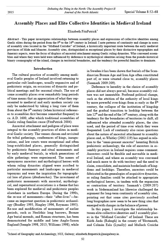
In this paper, I investigate the relationship between
elite collective identities and 3 assembly places
in the “Midland Corridor” of Ireland. These are
Ráith Áeda (Rahugh) in the county of Westmeath,
and Colmán Eala (Lynally) and Mullach Croiche
Assembly Places and Elite Collective Identities in Medieval Ireland
Elizabeth FitzPatrick*
Abstract - This paper investigates relationships between assembly places and expressions of collective identities among
Gaelic elites during the period from the 9th to the 16th century in Ireland. I note patterns of continuity and change in users
of assembly sites located in the “Midland Corridor” of Ireland, a historically important route between the early medieval
provinces of Mide and Munster. Assembly sites, distinguished as exceptional places by their distinctive topographies and
funerary aspects, were the focus of displays of ancestral attachment among Gaelic ruling dynasties. Who convened assemblies
and where they were held were influenced by deference to mythological identities arising from the pseudo-historical
binary cosmography of the island, changes in territorial boundaries, and the tendency for powerful families to dominate.
Debating the Thing in the North: The Assembly Project II
Journal of the North Atlantic
*School of Geography and Archaeology, NUI, Galway; elizabeth.fitzpatrick@nuigalway.ie.
2015 Special Volume 8:52–68
Journal of the North Atlantic
E. FitzPatrick
2015 Special Volume 8
53
(Mullaghcrohy) in the county of Offaly (Fig. 1).
Historically, the sites were located in the province
of Mide ruled by the powerful Southern Uí Néill
kings of Tara. It will be seen that over the period
from the 9th to the end of the 16th century, different
factors, from deference to mythological identities to
dominance of one sept over another and geopolitical
change in territorial boundaries, influenced the
collectives that gathered at these sites for different
forms of assembly. Ráith Áeda was the locus of an
early medieval rígdál (a conference of kings) in the
9th century (Mac Airt and Mac Niocaill 1983:317),
and Colmán Eala was celebrated in the 9th century as
one of the principal óenach (tribal assembly) sites
of Ireland (Meyer 1906:x–xi, 4–5). Both assembly
places had after-lives as lordly inauguration venues.
Mullach Croiche was adopted as the inauguration
site of a sept who appear to have been excluded
from accessing the landscape of Colmán Eala for
that purpose as a result of the acquisition of a part
of their territory by a dominant overlord in the later
medieval period (FitzPatrick 2004:30).
An explanation of the different types of assemblies
that were convened over this long period of
time, the kind of cultural landscape that their venues
represent, and what is meant by collective identity in
the context of Gaelic peoples, is a necessary preface
to the case studies that underscore the relationships
between assembly places and elite collective identities
in medieval Ireland.
Collective Identities and Gaelic Elites
In early medieval Ireland, the túath or petty kingdom
was the basic territorial unit, and it has been
defined as a population group that formed a distinct
political entity (Byrne 1973:7–8). Names of early
medieval kingdoms, often in the form of eponyms,
refer to their heroic founders, real or imagined.
The island-wide early medieval map of territories
was a great jigsaw of collective names that mostly
stemmed from the personal name of a progenitor
who was cited as the one from whom the people
of a kingdom ultimately claimed their descent. For
example, the midland people known as the Cenél
Fiachach, “the race of Fiacha”, claimed Fiacha
mac Néill (son of Niall of the Nine Hostages) as
their progenitor, and their territory carried his name
(Byrne 1973:93, Woulfe 1923:688). Throughout
Ireland, territory and landholding was framed by a
concept of geography as lineage (Leerssen 1994:17).
The most primordial of tribal identities was
based on a mythological north–south division of the
island between the sons of Míl of Spain, Éremón
and Éber, in remote prehistory. By A.D. 8th century
that division was described in terms of the sons
of Éremón and Éber, Conn and Mug. Conn had
possessed the northern half of the island, or Leth
Cuinn, and Mug ruled the southern half, Leth Moga
(Doherty 2005:274–276). The sinuous glacial moraine
known as the Eiscir Riada (ravaged by modern
quarrying), which crosses Ireland from near Dublin
through the midlands into the county of Galway, was
designated as the boundary between the two halves
in the pseudo-historical presentation of the past. The
tale of the battle of Mag Lena, at which Conn fell defending
Leth Cuinn, is appropriately set on the north
side of the Eiscir Riada. Mag Lena is an expansive
plain extending between Tullamore and Durrow in
northern County Offaly. The binary cosmography
of the island was later elaborated in Lebor Gabála
Érenn, The Book of the Taking of Ireland, compiled
in the late 11th or 12th century (Toner 2005:233–234).
In the early medieval concept of territorial division
there is concern with expressions of group affiliation
and collective identities relating to eponymous
ancestors. The powerful Uí Néill dynasty and the
Connachta claimed Conn as their ancestor, while
the Eóganachta dynasty of Munster cited Mug as
their progenitor (Doherty 2005:274). In the Irish
medieval past, genealogies were, where necessary,
fabricated for nouveau dynasties in order to align
with a northern or southern collective identity, and
ancestral associations with funerary monuments in
prehistoric cult landscapes used for assembly were
contrived in order to maintain assumed primordial
relationships (FitzPatrick 2004:97).
Although group identification with the túath was
eclipsed by the formation of lordships in Ireland
after the Anglo-Norman settlement of the late 12th
and 13th centuries, the Gaelic lordship or oireacht,
in many instances, continued to use the name of the
alleged progenitor of the ruling family—hence the
names Tír Eogain (Eogain’s country) and Tír Conaill
(Conaill’s country) for two of the most powerful
lordships of later medieval Ulster. In origin, the
term oireacht meant a public assembly, a court of
law or a territorial council (Simms 1987:176), but in
the sense that it is used to define the later medieval
Gaelic lordship, it implies the assembly of the people
and their territory which, like the earlier túath,
emphasizes the indivisibility of people and place in
the Gaelic tradition.
Meetings
The assembly place, perhaps more than any other
cultural landscape in the early medieval kingdoms
and later medieval lordships of Ireland, expressed
synonymy between people and territory. It was the
center and often the borderland where geopolitical
space was demarcated and attachment to a dynasJournal
of the North Atlantic
E. FitzPatrick
2015 Special Volume 8
54
tic archetype was enacted (Mullin 2011:1–12).
Of course, the center and the boundary could and
did move and could be established anew in an appropriate
cult landscape when new territory was
acquired, when septs split, or when royal lands were
annexed as a result of Anglo-Norman colonization
in Ireland. Every túath or petty kingdom and each
over-kingdom and provincial king in early medieval
Ireland had an open-air assembly place. Meetings
of the early medieval túath have different names
signifying their purpose—the airecht, which was a
law court and occasion for parleys between warring
parties; the oirdneadh or ríoghadh, which was an
ordination or enkinging; and the óenach, which was
a periodic or seasonal meeting of a túath or a larger
territory such as a province. The óenach was one of
the more significant meetings, held on the occasion
of the quarterly feasts of the old Irish year—Imbolc,
Beltaine, Lughnasa, and Samhain. Each quarter of
the year began with a festival at the assembly place
of the túath, but it is the óenach at Lughnasa about
which most is known (MacNeill 1962:311–349).
In modern Irish the word óenach means “a fair”
and has commercial connotations, but in Old and
Middle Irish it is interpreted as a political assembly
with ritual associations, distinguished by horse and
chariot races and trading/markets and social festivities
(Bhreathnach 2014:73; Quin 1983:485). In fact,
the primary meaning of the Old Irish word aige, the
act of driving or racing horses, is used in the 9th- and
10th-century native chronicles to indicate the convening
of an óenach (Etchingham 2011:40). What is
important is that the games of the óenach are associated
with funerary culture.
High-level meetings of early medieval kings also
took place but appear to have been unique to the 9th
century in Ireland and convened by the Southern
Uí Néill king (Bannerman 1966:122–123, Charles-
Edwards 2000:279–281). Termed rígdál in the Irish
language, four such colloquies of kings are noted
in the native chronicles—those convened at Birr
(County Offaly) in A.D. 827, at Cloncurry (County
Meath) in A.D. 838, at Armagh (County Armagh) in
A.D. 851, and at Ráith Áeda (County Westmeath)
in A.D. 859 (Mac Airt and Mac Niocaill 1983:285,
297, 311, 317).
Occasions of assembly in later medieval Ireland
reflect the new political reality of lordships. There
were just 60 Gaelic lordships in later medieval
Ireland, in comparison to hundreds of former early
medieval túatha of petty kings and larger territories
of over-kings. The óenach ceased to be an institution
of kingship after the 12th century. Whether it continued
as an occasion for popular gathering to celebrate
seasonal rituals is not known, but late survivals of
Lughnasa festive assemblies held by regional communities
in Ireland in the modern period, which
have been viewed as survivals of earlier assembly
practices in some instances, may suggest that not all
óenach sites were abandoned outright after the 12th
century (MacNeill 1962). The characteristic meetings
of later medieval lordships include the oireachtas,
which was an assembly or parliament, and the
gairm anma/ ord an anma, which was a proclamation
of the name or ritual of the name indicating the
election of a lord or chief (Simms 1987:32–33, 175).
A particular site within the former óenach venue
of the patrimonial túath of a lord was often but not
always carried through as the assembly place of the
lordship. Magh Adhair in the county of Clare is an
example of an assembly landscape that enjoyed such
continuity (FitzPatrick 2004:52–59).
Topography
There are topographies and archaeologies unique
to early medieval assembly places that can make
them visible again in the modern landscape. Assembly
places tend to be located in rocky pasture
in terrain where the geology is broken and very
close to the surface, a fact often indicated by the
presence of quarries and mines in their landscapes
and the frequency of the Irish word brecc/breac
in place-names, usually translated as dappled or
speckled (Quin 1983:82), but which I would argue
is more accurately read as brecciated, in reference
to rock composed of angular fragments or clasts of
stone. Place-names incorporating the words finn/
fionn (bright, white, lustrous) and bán (white) occur
in óenach settings too and, like breac, can be
indicative of mineral and metal occurrences in a
locality. Landscapes explored in this paper incorporate
townlands that carry the root word breac in their
place-names. The townlands of Bracklin Little and
Bracklin Big, from the Irish breaclainn, meaning
“speckled place”, lie across the Silver River south of
Ráith Áeda, and the townlands of Cloghabrack (na
cloche breaca,;“the speckled stones”) and Brackagh
(an bhreacach; “speckled place”) are integral to the
óenach landscape of Colmán Eala.
The modern landscape contexts in which former
medieval assembly places are found give the impression
that meetings were conducted in open countryside
affording unimpeded views, but an appreciation
of historical land use suggests that several assembly
sites were set close to or in major clearings of
woodlands. The 12th-century dindshenchas poem on
the origins of Taltiu (Teltown, County Meath), the
island-wide óenach hosted by the Southern Uí Néill
kings of Tara, explains that the landscape in which it
lay was once “a thicket of trees” and the location of a
place called Assuide—“the seat of the hunt, whither
Journal of the North Atlantic
E. FitzPatrick
2015 Special Volume 8
55
gathered the red-coated deer” (Gwynn 1924:149).
The poem explains that the place of the óenach was
created when Taltiu, the daughter of Magmor, reclaimed
meadowland from the wood, which became
the great plain of Bregmag in which the assembly
place stood. Their sylvan aspect is of course also
borne out by the evidence for primordial oak woods
in the vicinity of assembly places such as Colmán
Eala in Offaly (Magner 2011:375). The idea that the
genealogy of medieval Irish kings could be found in
woodland, in the place of the hunt, and revealed by
felling trees and clearing the overgrowth that had
masked and hidden the burial and ritual places of
progenitors, may be significant in view of the importance
for newly arrived dynasties to demonstrate
long lineage that involved a pre-Christian past. Of
course, the overlap between assembly places and
woodlands would also have had a practical basis—
crowds attending assemblies needed to be fed. Pork
has been described as “the meat of the feast” in early
medieval Ireland (Ní Chatháin 1979:201). Wild
swine/boar were hunted in Irish woodlands, and it
is possible that they were ritually coursed as one of
the sporting contests of an óenach with the beneficial
outcome of producing food for the assembly (Fitz-
Patrick 2013:112–117).
Funerary Landscapes
The archaeological profile of early medieval tribal
assembly places is overwhelmingly funerary and
distinguished by a range of sepulchral monuments,
generally prehistoric in origin, characterized by
megalithic tombs with and without their cairn coverings,
as well as later Bronze Age and Iron Age burial
and ritual monuments (Breathnach 2014:69–77,
FitzPatrick et al. 2011:163–164). However, there is
also the expectation of early medieval royal burials
in these landscapes between the 5th and 7th centuries
and an intimation of such in the literature in relation
to the burial places of particular kings. Elizabeth O’
Brien (2009:135–154) has shown that both long cists
and unprotected burials (often of females) of the 5th
and 6th were sometimes placed into prehistoric burial
monuments at the boundaries between territories,
and that there are a small number of instances of
unprotected burials being inserted into prehistoric
funerary monuments during the 7th century. The
fanciful Life of St. Cellach of Killala claims that the
early historic king of Connacht, Eogan Bél, was buried
at the tribal assembly place of Lough Gill in the
county of Sligo in the northwest of Ireland, which
is predominantly a prehistoric funerary landscape
(FitzPatrick 2013:106–110).
Where dramatic surface expressions of sepulchral
monuments are absent, place-names derived
from Old Irish fert, which translates as a grave, usually
of a person of high status (Swift 1996:14), can
reveal the essential if invisible funerary character of
an óenach landscape. O’Brien (2009:142–143) and
O’Brien and Bhreathnach (2011:55) have refined
this definition and suggest that a fert is an ancestral
burial place, regarded by the 7th-century Bishop
Tírechán as a pagan grave, usually but not consistently
a reused prehistoric sepulchral monument, a
natural hillock perceived as an ancient burial place,
or an early medieval mound imitating prehistoric
prototypes. More specifically, O’Brien and Bhreathnach
(2011:55) suggest that a fert or ferta (a group
of graves or more than one burial in a single mound)
may occur in the form of a mound, a ring-barrow,
or a circular ditched enclosure. Ancestral burial
places were important as boundary markers and
were especially invoked in disputes over territorial
claims (Charles-Edwards 1976:83–87). In order to
make a claim to land, approval from the ancestor(s)
perceived to be buried in a boundary fert/ferta had
to be sought, as they were viewed as guardians of
the land or territory in dispute. Archaeological investigation
of burials identified as boundary ferta
indicate that in the period A.D. 400–700 new burials
were inserted into them. This practice can be interpreted
in different ways. O’Brien and Bhreathnach
(2011:55) suggest that the insertion of burials into
an existing prehistoric burial in a boundary location
may have been done by the dynasts of a kingdom
in order to reinforce their claim to their territory,
or it could have been the case that burials were introduced
by an intrusive group in order to associate
themselves with prehistoric “ancestors” and thereby
legitimize their claim to new territory. The ancestral
boundary fert assumes particular importance in
assembly landscapes of early medieval Ireland. Ó
Riain (1972:12–29) observed that assemblies were
regularly convened at boundary locations but did
not note that place-names derived from old Irish
fert occur at several known assembly places. To
mention some, there is the townland of Fertaun (an
feartán) in the óenach landscape of Colmán Eala in
the early medieval kingdom of Cenél Fiachach, and
the townland of Fartan northwest of Shantemon hill,
which was an assembly place in the south Ulster
kingdom of East Bréifne used as late as 1596 for the
inauguration of the O’Reilly lord of that territory
(FitzPatrick 2004:112–113, MacNeill 1962:174).
Funerary monuments, ancestors, gatherings, and
territoriality coalesce in the assembly landscapes of
early medieval Ireland.
Ráith Áeda and Mythological Identities
The Eiscir Riada, that mythological boundary
between the quintessential primordial collective
identities of Leth Cuinn and Leth Moga, forms the
Journal of the North Atlantic
E. FitzPatrick
2015 Special Volume 8
56
southern backdrop to Ráith Áeda as it winds its broken
way across the Central Plain of Ireland (Fig. 1).
The Irish eiscir, anglicized “esker”, translates as
a line of low mounds but has a specific geological
meaning as a narrow and generally sinuous ridge of
sand, lacustrine and sorted silts and clays, gravels,
and large boulders formed in an ice-walled channel,
left behind by sub-glacial rivers during the Midlandian
or final ice age in Ireland (Sheehan 1993:1–2,
Tubridy and Meehan 2006b:13). The Eiscir Riada
is not a monolithic landform, a single continuous
raised ridge. Typical of the eskers in the midlands of
Ireland, it is mostly discontinuous and does not run
in a straight line, nor is its orientation precisely east–
west (Fig. 1). The Eiscir Riada, and the Slighe Mór
or “great road” which followed its approximate line
between Dublin and the county of Galway, constituted
several esker systems along its midland section
(Tubridy and Meehan 2006a:20). At Ráith Áeda, the
Eiscir Riada is a high wooded ridge called “Rahugh
Ridge” (Fig. 2), which because of its rich ground flora
and associated wildlife is listed as a scientific area
of international importance. It is described as having
the best woodland in the county of Westmeath, particularly
distinguished by Sorbus hibernica or Irish
Whitebeam (Sheehan 1993:23, Tubridy and Meehan
2006a:137). Rahugh Ridge is 2.5 km long, covering
61 ha in south Westmeath and north Offaly, the eastern
limit of which is also the point of convergence of
3 distinct esker systems which disappear beneath an
extensive bog in this part of Westmeath (Tubridy and
Meehan 2006a:13, 137).
The role of the Slighe Mór as an overland artery
of communication in early medieval Ireland is
confirmed by its proximity to major early medieval
midland monasteries, such as Clonmacnoise, Durrow,
Lemanaghan, Rahan, and Ráith Áeda. However,
the ideological position of pseudo-history,
Figure 1. Assembly places and the early medieval kingdoms of Cenél Fiachach and Delbna Ethra, showing the system of
eskers and the characterization of Cenél Fiachach as a route or pass, termed the “Midland Corridor”, between the rival
provinces of Mide and Munster (map by Richard Clutterbuck).
Journal of the North Atlantic
E. FitzPatrick
2015 Special Volume 8
57
which extended from what is now the southern area
of County Westmeath at Clonfad and Tyrellspass,
south past Ráith Áeda and the Eiscir Riada into
southern Offaly (Fig. 1). The medieval geography
of the corridor incorporated the entire territory of
Cenél Fiachach, which was coterminous with the
later baronies of Moycashel in Westmeath and Ballycowan,
Ballyboy, and Eglish in Offaly. This corridor
territory had the alternative name Fir Chell,
which translates as “Men of Churches” and derived
from the fact that several important early medieval
monasteries, including Durrow, Tihilly, Rahan,
Lynally (Colmán Eala), Kinnity, Seirkieran, and
Birr were founded along its north–south route from
the province of Mide into the province of Munster
(Byrne 1973:93, Smyth 1982:86–87). Charles-
Edwards (2000:298) has argued that the emergence
of Fir Chell as an alternative name for the lands of
the Cenél Fiachach south of the River Brosna could
have been the result of a policy of the dominant
Southern Uí Néill kings of the province of Mide
in which early medieval society viewed the Eiscir
Riada as separating 2 distinct primordial lineages,
has not yet been attributed any role in place creation.
In support of that, the selection of Ráith Áeda as
the location for a significant royal colloquy in the
9th century, the continuity of the site as the venue
for the inauguration of the Mic Eochagáin lords of
Cenél Fiachach in the later medieval period, and the
typical topographical and archaeological profile of
its greater landscape as a place of assembly suggests
that the pseudo-history relating to the Eiscir Riada
as a boundary between distinct peoples was a potent
instrument of place creation in the midlands of Ireland
and especially in the inter-tribal zone called the
“Midland Corridor” where the borders of the major
provincial over-kingdoms of the island joined.
The term “Midland Corridor” was developed
by Alfred Smyth (1982:86–87) for his pioneering
historical geography of medieval Leinster. He
described it as a tract of open fertile countryside
approximately 20 miles long and 2 to 4 miles wide
Figure 2. Prehistoric and medieval landscape of Ráith Áeda and its hinterland (map by Richard Clutterbuck).
Journal of the North Atlantic
E. FitzPatrick
2015 Special Volume 8
58
setting of the rίgdál is the Escir Riada defined
by Rahugh Ridge (Figs. 1, 2), combined with
topography of multiple small ridges, hillocks, and
deep cup-shaped hollows (Sheehan 1993:14). The
Silver River flows due southwest of Rahugh Ridge
forming the southern boundary of the parish of
Ráith Áeda in this area. The archaeology associated
with the rίgdál is focused within the townland of
Ráith Áeda where the early medieval church of St.
Áed mac Bricc is situated (Fig. 2). The church was
founded in the 6th century by Áed, who is portrayed
by the 8th-century author of his Life (biography) as
a saint of the border between the Southern Uí Néill
kings of Mide and the kings of Munster (Charles-
Edwards 2000:445–446). The saint’s genealogy
placed him in the house of Uí Néill as a direct
descendant of Fiacha, whom the Cenél Fiachach also
claimed as their progenitor.
The foundation attributed to Áed was once
surrounded by an earthen vallum, a portion of which
survives on the northeastern side of the graveyard
and which may be the ráth or earthen enclosure
indicated in the place-name Ráith Áeda. The holy
well of St. Áed lies south of the church, and an early
medieval grave-slab, decorated with an equal-armed
wheeled cross, is recorded from the site (Stokes
1896:331–332). However, as a place of early
medieval assembly, this ostensibly ecclesiastical
archaeology is lightly drawn over a deeper
palimpsest of prehistory (Fig. 2). A bowl-barrow—a
dome-shaped sepulchral mound—enclosed by a
fosse of perhaps Bronze Age or Iron Age period is
situated northwest of the church on the summit of a
low drift ridge locally known as Knockbo or Cnoc
Buadha, translated as the “Hill of Triumph”, and
which is part of the esker system in this landscape
(Fig. 3). Cnoc Buadha is a highly visible landmark
which can be picked out on the skyline from the
church and from other locations in the hinterland.
It may have been connected to the church by a
routeway preserved in the line of a narrow roadway
that runs northwest for ~600 m from the church
towards the barrow and northwards to Bonfire Hill
in the townland of Aghuldred (Fig. 2). I have argued
elsewhere (FitzPatrick 2005:273–275) that the
barrow may have been re-used as a throne-mound,
the focus-point in the landscape from which Máel
Sechnaill presided over the rígdál of A.D. 859. Apart
from the barrow, a Bronze Age burial consisting of a
short, rectangular cist that contained some cremated
bone and “two pots” was found in 1903 in “a gravel
ridge” at Ráith Áeda (Waddell 1985:151). During
the second half of the 19th century, the remains of
what was described as a stone circle “from which
all the stones [had] been removed except seven,
and of these only one [remained] perpendicular”,
to reduce the resources of the Cenél Fiachach “by
granting away lands to churches in its territory”.
The strategic importance of Cenél Fiachach as a
corridor into Munster was understood by the Southern
Uí Néill kings of Mide when they annexed that
territory, allegedly sometime in the 5th century
(O’Donovan 1841:51–52, n. 173). Certainly, from
the 8th century the power of the petty kings of Cenél
Fiachach and their neighbors, the Delbna Ethra,
was eroded, with a corresponding increase in the
dominance of the Southern Uí Néill kings of the
province of Mide in this region. This development
towards Continental-style powerful over-kings,
traceable from as early as the 8th century in Ireland,
is also witnessed in the form of address towards
petty kings under the control of dominant overkings.
The king of Cenél Fiachach is referred to as
tigerna (lord) in A.D. 740, and the king of his vassal
kingdom of Delbna Ethra is called dux (Ó Corráin
1972:29–30, Simms 1987:10–11).
In A.D. 859, a rίgdál took place on the northern
side of the Rahugh Ridge that constituted part of the
Eiscir Riada on the lands of the monastery of Ráith
Áeda (Fig. 2). The rίgdál was convened by Máel
Sechnaill (846–862), the Southern Uí Néill overking
of Tara, in the synthetic division of Leth Cuinn. The
purported intention of the rίgdál was “to make peace
and amity between the men of Ireland” (Mac Airt
and Mac Niocaill 1983:317), but its real purpose
was a display of power by the Southern Uí Néill in
the midland boundary zone between their lands and
those of the rival king of Munster, Máel Gúala of
Leth Moga, the fabled southern half of the island. At
Ráith Áeda, the recalcitrant Munster kingdom of Osraige
that had been acting independently of the king
of Munster, was drawn into the jurisdiction of the
Southern Uí Néill (Charles-Edwards 2000:476, Fitz-
Patrick 2005: 268–269, Ó Corráin 1972:99–100).
This served to consolidate Máel Sechnaill’s dominance
over Munster, a goal which he had already
advanced through his less-cordial military campaign
in Munster in A.D. 858 (Ó Corráin 1972:99). The assembly
of A.D. 859 was a singular assembly event at
Ráith Áeda during this time, of national rather than
local importance, and presided over by an aspirant
high-king of all Ireland. The fact that this dramatic
event unfolded in the landscape of the Eiscir Riada
at Ráith Áeda rather than further south on the boundary
between the kingdoms of Cenél Fiachach and
Éile, which constituted the actual border between
the provinces of Mide and Munster, confirms the role
of the esker system as the physical manifestation of
the ideological binary division of the island and the
importance attached to it by an aspirant high-king of
the island as a place to dominate those opposites.
The prevailing presence in the glacial landscape
Journal of the North Atlantic
E. FitzPatrick
2015 Special Volume 8
59
were also recorded in Ráith Áeda (Anon 1870–
1871:27–28). No trace of this monument survives
in the intensively farmed townland. Stone circles
are attributed to the period 1700–800 B.C. in Ireland
(Waddell 2010:178). In the townland of Lowertown,
which adjoins Ráith Áeda on its west side, there is
an upright stone standing almost 1 m high in open
grassland (Fig. 4). It is situated a short distance
northeast of an impressive bivallate ráth, an enclosed
settlement of early medieval origin which sits on the
summit of a drift ridge. Further west in the townland
of Frevanagh, 2 monuments—a cairn and a possible
barrow—were recorded on the current-edition
Ordnance Survey six-inch map and cleared during
more-recent land improvement in the area. The cairn
carried the name “Slaghta” from the Irish sleachta,
which means grave, grave-mound, or monument.
The cumulative evidence of prehistoric monuments
in the townland of Ráith Áeda and in the townlands
immediately to the west of it suggests an intensity
of pre-Christian funerary and ritual practices in this
landscape (Fig. 2).
Although the archaeological profile of the Ráith
Áeda landscape is appropriate to an early medieval
assembly place, it is unknown whether the early
medieval Cenél Fiachach habitually used this site
as their place of assembly before and after the rígdál.
As discussed below, it can be argued that the
tribal assembly place of Cenél Fiachach was Colmán
Eala, situated further south in their territory in the
boundary zone with Delbna Ethra and the Leinster
kingdom of Uí Failge (Figs. 1, 5). However, the
later medieval descendants of the kings of Cenél
Fiachach, the Mic Eochagáin lords, who ruled the
diminutive lordship of Cenél Fiachach (coterminous
with the modern barony of Moycashel in County
Westmeath), frequented Cnoc Buadha at Ráith Áeda
for their inauguration ceremonies (Fig. 3). The Mic
Eochagáin lords of Cenél Fiachach claimed their
descent from Fiacha mac Néill, the progenitor of
the Cenél Fiachach, thereby displaying a northern
or Leth Cuinn affiliation (Byrne 1969:12, Charles-
Edwards 2000:446). The use of Ráith Áeda as their
place of inauguration may not so much represent
continuity of use from the early medieval period as
a concern to connect themselves with the location
of the once victorious rίgdál of A.D. 859 and their
tribal roots in Leth Cuinn.
Cenél Fiachach came under the control of the
Anglo-Norman knight Hugh de Lacy in the late 12th
century when he was granted the province of Mide.
A series of earthen and timber motte castles, strung
out across the Eiscir Riada system in the townland
of Atticonor at Ráith Áeda (Fig. 2), at Colmán
Eala, Durrow, Horseleap, Moate, Mount Temple,
and Athone, are attributed to the process of subinfeudation
that followed in central Ireland (O’Brien
1998:169–171, Sheehan 1993:34). The petty kings of
Cenél Fiachach became tenants of their Anglo-Norman
overlords. From the 13th century and throughout
the 14th century, the centralizing administration
of Edward I (1272–1307) in Ireland determined to
Figure 3. Bowl-barrow on Cnoc Buadha at Ráith Áeda (photo © E. FitzPatrick).
Journal of the North Atlantic
E. FitzPatrick
2015 Special Volume 8
60
(Cox 1976:86–87; National Library of Ireland, MS
G 192, 306). Alongside that development, the presence
of a large moated site in the townland of Pallas,
northwest of the townland of Rahugh, suggests that
the Mic Eochagáin lords may have had a pailís, an
elaborate timber hall, built for themselves in the 14th
century near to their place of assembly (Fig. 2). The
Irish pailís (anglicized pallas) is variously translated
as a palisade or stockade, a palisaded enclosure or
fortress, a castle, and a palace (Quin 1983:494).
disable the authority of all local Gaelic kings. This
gradual process is reflected in Crown documentation
that, soon after 1300, addresses Irish leaders
as duces rather than reges and sometimes just by
their names with the distinguishing qualification
hibernicus (Simms 1987:36–37). In these new political
circumstances, Cnoc Buadha, the “Hill of
Triumph” at Ráith Áeda (Fig. 3), had an after-life as
the inauguration site of the Mic Eochagáin lords of
Cenél Fiachach down to the end of the 16th century
Figure 4. A standing stone and ráth at Lowertown in the assembly landscape of Ráith Áeda (photo © E . FitzPatrick).
Journal of the North Atlantic
E. FitzPatrick
2015 Special Volume 8
61
by the dynasts of Cenél Fiachach, before Anglo-
Norman colonization in the Irish midlands (Figs.
1, 5). It has already been shown that the kingdom of
Cenél Fiachach constituted a pass or route described
as the “Midland Corridor” (Smyth 1982:86–87).
The kingdom straddled the mythological binary
division of the island (Fig. 1) but lay firmly in the
province of Mide because it had been annexed by
the Southern Uí Néill, allegedly as early as the 5th
century (O’Donovan 1841:51–52, n. 173), and was
certainly dominated by that powerful dynasty by the
8th century (Ó Corráin 1972:29–30).
Colmán Eala was situated in the kingdom of
Cenél Fiachach ~10 km southwest of Ráith Áeda,
on the south side of the Clodiagh River which flows
into the River Brosna. Colmán, who lived during
the 6th century and died in A.D. 611, perhaps at 55
years of age, is recognized as the founder saint of the
monastery of Lann Eala, anglicized Lynally (Ó Riain
2011:203). The Irish lann is a cognate of the Welsh
llan and English land. It is often followed by a saint’s
However, pailís as used in a 14th-century context in
Gaelic Ireland implies an elaborate timber hall befitting
a king but used by Gaelic elites who were reduced
to the status of lords by the centralizing power
of the English Crown (FitzPatrick, in press). In the
creation of a pailís and the re-use of the rίgdál site
as a place of inauguration, the Mic Eochagáin lords
may have been consciously reviving their collective
identity as Cenél Fiachach linked to the memory
of the powerful Southern Uí Néill kings and the
dominance of the primordial tribe of Leth Cuinn on
the north side of the Eiscir Riada.
Colmán Eala, Mullach Croiche, and Shifting
Collective Identities
It can be argued that the óenach of Colmán Eala,
mentioned as one of “the three óenaig of Ireland
[trí háenaig hÉrenn]” in the 9th- century Triads of
Ireland (Meyer 1906:x–xi, 4–5), was the habitual
venue for seasonal tribal assembly presided over
Figure 5. The archaeology and landscape of the Óenach of Colmán Eala (map by Richard Clutterbuck).
Journal of the North Atlantic
E. FitzPatrick
2015 Special Volume 8
62
personal name in Welsh usage and indicates the presence
of an enclosed church and cemetery and the
land served by a parish (Roberts 1992:43–44). No
Welsh connection has been established for Colmán’s
church, but the neighboring monasteries of Gallen
and Lemanaghan are accorded Welsh associations
in the Annals of Clonmacnoise (Murphy 1896:107,
131). The remains of St. Colmán’s early medieval
church, which was modified in the 15th century, and a
graveyard are encompassed by a large earthen enclosure
detectable as a crop mark. A fanciful foundation
tale is connected with the creation of the enclosure
around the monastery in Colmán’s Latin Life. Having
demonstrated his higher powers to the Cenél
Fiachach by banishing the pestilent monster of Loch
Eala, the saint set about constructing an enclosure
for his monastery with the assistance of the sons
of the local king, Duinecha and Cuineda (Plummer
1910:162, 166). The enclosure is possibly the lann
referred to in the place-name (FitzPatrick 1998:105).
As might be expected of a monastic foundation
in the province of Mide, Colmán is attributed an
Uí Néill genealogy by the author of his Latin Life,
and a tract on the Cenél Fiachach claims Colmán
as their pre-eminent saint (Ó Riain 2011:203, 205).
The deliberate attachment of the saint to the collective
tribal identity of Cenél Fiachach is significant in
respect of the óenach named after him. The Óenach
of Colmán Eala, like other óenaig associated with
saints, has been generally viewed as monastic and
largely commercial, without the political and ceremonial
aspects associated with secular óenaig such
as the island-wide Óenach Tailten and the provincial
Óenach Cruachna, but Etchingham (2011:41–42)
has pointed out that since the Óenach of Colmán
Eala is listed as one of the three óenaig of Ireland
along with Óenach Tailten and Óenach Cruachna,
there is no reason not to believe that it was a political
assembly and that it included funerary games
such as racing. The archaeology and topography of
the site and the connection of at least one aspect of
the saintly cult of Colmán with horses suggests that
the Óenach of Colmán Eala was a seasonal tribal
gathering with all of the ritual expectations of such
an assembly. Colmán’s cross was invoked as a protection
against being thrown from a horse (Ó Riain
2011:205), a talisman that may have been especially
called upon by those about to race horses or partake
in any other sporting contests involving horses at an
óenach. The fact too that a select point, Ardnagross
hill (Fig. 5) in the landscape of the Óenach of Colmán
Eala, was adopted by the later Mic Chochláin
lords of Delbna Ethra as the venue for their inaugurations
and parliaments suggests that, despite the
association of the óenach with a Christian saint and
his monastery of Lann Eala, this event and its setting
retained a strong secular personality rooted in its
origins as a ritualized political assembly of the Cenél
Fiachach tribe rather than a monastic market.
Determining the extent of the óenach landscape
is problematic because important matters, such as
the use to which funerary monuments in óenaig
landscapes were put and how people moved through
these places, are as yet under-investigated aspects of
assembly culture. The challenge is compounded by
modern, callous attrition of the cultural landscape
of Colmán Eala due to extensive quarrying, intensive
farming, and more-recent motorway development,
which have completely altered the historical
geography and removed most of the archaeology
and topographical landmarks related to the óenach.
However, using topographical, place-name, and
archaeological indicators of assembly places, as
outlined earlier in this paper, a block of townlands
south of St. Colmán’s monastery of Lann Eala can
be identified with some confidence as components
of the óenach landscape (Fig. 5). These townlands
include Screggan, Mucklagh, Cloghabrack, Brackagh
and Cloghanbane, Fertaun, Claragh, Heath and
Shanvally, Ross, and Killurin—an area of approximately
15 km2 flanked on its east and west sides by
woodland and to the south by a marsh between Ross
and Kilurin. The most significant natural attribute
of this region was woodland. The earlier historical
names “Fid Elo” and “Silva Elo”, which translate as
“the wood of Lann Eala”, may indicate significant
oak woodland here (Hogan 1910:417). The so-called
“King Oak” of Charleville Demesne, east of Lann
Eala (Fig. 5), with a girth of ~8 m and an estimated
age of at least 400 years is regarded as a descendant
of the great woods of common oak (Quercus robur)
that once covered the Central Plain of Ireland (Magner
2011:73–375, Nicholls 2001:181, Pakenham
1997:27).
The topography of this landscape is glacial,
related to the esker system further north and distinguished
by a glaciofluvial fan—deposits of outwash
that form a fan shape as they spread out over the land
surface (Tubridy and Meehan 2006b:15). In keeping
with most assembly places, the core of the óenach
landscape is rocky pasture with shallow soils characterized
by Rendzinas and Lithosols. The highestpoint
of the óenach landscape is Ardnagross hill at
80 m above sea level, situated in the townland of
Screggan immediately south of St. Colmán’s monastery
of Lann Eala (Fig. 5). Ardnagross was a glacial
ridge, the center of which was entirely quarried out
for gravel and sand during the 20th century. Notwithstanding
the fact that this was a well-wooded
region during the medieval period, from the summit
of Ardnagross distant views could be had west into
the adjoining kingdom of Delbna Ethra and south
Journal of the North Atlantic
E. FitzPatrick
2015 Special Volume 8
63
towards the Slieve Bloom Mountains into the province
of Munster. A spring well was situated on the
northeast side of the ridge, and to the south a linear
earthwork, ~350 m long, was cleared during decades
of “improvement” in this landscape.
The Screggan earthwork was one of a series of 5
discontinuous linear earthworks, some accompanied
by ditches and the others occurring in the townlands
of Cloghbane, Fertaun, and Killurin and between
Heath and Shanvally (Fig. 5). These were each recorded
on the 19th-century first-edition Ordnance
Survey six-inch maps for this area, and all have since
been cleared from the landscape. The role of linear
earthworks in Ireland remains unresolved. They can
be described as discontinuous single or parallel lines
of bank and deep ditch, usually beginning or ending
at a lake, a bog, or lower slopes of hilly or mountainous
terrain. They vary greatly in form and length
and clearly cannot all be assigned the same role (Ó
Drisceoil 2015, Waddell 2010:379–382). The theory
that they were all used to control movement of
people and cattle is challenged by their discontinuous
form and by the fact that they can be as short as
100 m. Some linear earthworks in Ireland, such as
the Black Pig’s Dyke in Ulster, have wild-pig folk
tales attached to them and are also associated with
the wild-pig place-name muclach, anglicized mucklagh
and translated as “piggery” (Quin 1983:469).
The most renowned muclach association occurs at
Cruachain, the pseudo-historical capital and óenach
site of Connacht. Two parallel curving banks of earth
called the “Mucklaghs”, each ~12 m wide, 3 m high,
and ~100 m long with a narrow defile of no more
than 1.5 m between them, are attributed in folklore
to the rootings of a magical boar (Waddell et al.
2009:89–103).
Parallel linear earthworks were also a feature
of the óenach landscape of Taltiu in the county of
Meath. Excavation of the surviving portion of the
southern earthwork indicated that while the lowest
levels of the embankment could be attributed to
late prehistory, it was modified about the 8th century
and again in the 9th or 10th A.D., suggesting that this
was “deliberate reuse of a prehistoric monument or
possibly the deliberate construction of a prehistoric
form, though to what purpose is impossible to say”
(Waddell 2011:196–198). In view of the appetite for
games at an óenach and the need to feed people, it
could be tentatively proposed that the deep ditches of
these earthworks were used for ceremonial coursing
of wild pig as a sporting contest of the óenach. It is
notable that a townland called Mucklagh also occurs
in the area proposed as the location of the óenach of
Colmán Eala, east of Screggan, in a landscape that
once contained several linear earthworks (Fig. 5).
If the archaeological profile of óenach venues is
quintessentially funerary, the place where the óenach
of Colmán Eala was held should be no exception
to that rule. There are no surface expressions of
prehistoric sepulchral monuments, but the townland
of Fertaun south of Lann Eala and west of Screggan,
preserves in its Irish-language place-name, an Feartán,
medieval knowledge of a grave of high status
(Fig. 5) and an indicator of an ancestral boundary
fert. The reality of prehistoric burial in the greater
landscape of the óenach is also confirmed by the results
of excavations at Mucklagh during 2006–2007,
which revealed a cremation burial in a pit (Fig. 5)
containing the partial remains of two individuals, an
adult female and a child, dated to the Early to Middle
Bronze Age transition (BP 1776 cal. B.C.–1601 cal.
B.C. 2 sigma; Lalonde 2008:47, Moloney 2011:1).
The cremated burials of the woman and child were
accompanied by an antler awl, fragments of copper,
and what has been interpreted as a Wessex-type
button or bead cover of sheet gold (91%), which
is an unusual find in the context of Bronze-Age
cremation burials in Ireland (Lalonde 2008:46–48,
Moloney 2011:1–2). While the place-name reference
to a high-status grave in an Feartán cannot be
directly linked with the prehistoric cremation burial
at Mucklagh, the combined evidence points to a funerary
aspect to this landscape, which is an imperative
of óenach locations. The presence of a fert is a
strong indicator of a boundary, with the implication
that this óenach location was once a significant focal
point on the territorial boundary between Cenél
Fiachach and the kingdom of Delbna Ethra (Fig. 1).
This interpretation would explain why, as late as
1591, the lordly descendants of the kings of Delbna
Ethra had themselves inaugurated on Ardnagross
Hill in the former óenach landscape of Colmán Eala
(Fig. 6).
It is generally accepted that the óenach as an
institution of kingship ceased after the 12th century.
However, prominent loci such as large sepulchral
mounds and natural hillocks in some óenach landscapes
had after-lives as assembly places of newly
formed Gaelic lordships. The geography of the
“Midland Corridor” altered again between the 12th
and 14th centuries with the emergence of the lordships
of Cenél Fiachach, Fir Chell, and Delbna
Ethra (Fig. 6). Cenél Fiachach, as explained above,
became a small lordship approximately a third of
the size of the original early medieval kingdom of
that name, ruled by the Mic Eochagáin lords, while
the rest of that once expansive kingdom became the
lordship of Fir Chell controlled by the Uí Mhaolmhuaidh
lords. The neighboring kingdom of Delbna
Ethra, bordering the River Shannon, emerged as
the powerful and acquisitive lordship of the Mic
Chochláin (Fig. 6). In this new geography, Ráith
Journal of the North Atlantic
E. FitzPatrick
2015 Special Volume 8
64
Áeda became the permanent assembly place of the
Mic Eochagáin lords, and Ardnagross hill, which
had been central to the óenach landscape of Colmán
Eala, became the inauguration site of Mic Chochláin
lords, while the Uí Mhaolmhuaidh lords of Fir
Chell used the hill of Mullach Croiche (Fig. 6) ~5
km southwest of Colmán Eala as their assembly
place (FitzPatrick 2004:218–219; National Library
of Ireland, MS G 192, folio 306). Mullach Croiche,
a round hill situated in rich farming land, has no recorded
archaeology but affords commanding views
from its summit. The period during which the hill
was first adopted by the Uí Mhaolmhuaidh as their
place of inauguration is not known, but it may have
occurred sometime during the 14th century when
they appear to have had a pailís constructed for
themselves in nearby Pallaspark townland (O’Brien
and Sweetman 1997:152). In effect, they created a
new lordly center for themselves at this time.
The use of Ardnagross hill, at the old óenach site
of Colmán Eala, by the Mic Chochláin lords for their
inaugurations and parliaments as late as the end of the
16th century, raises an important point about assembly
places, collective identities, and territorial boundaries.
There is a description of the inauguration of John
Mac Cochláin on the hill of Ardnagross in A.D. 1590.
In that year he assembled “the inhabitants of the said
countrie, so many as he could, upon the hill of Ard na
Grossa … and there after other ceremonies and rites
used in the creation of a Mac Coghlan did … receave
a scepter or white wand into his hands … Whereat the
people gave a shute as if they said vive le roy” (Mac
Cuarta 1987:116). During the early medieval period,
Delbna Ethra had been a sub-state of Cenél Fiachach
(Fig. 1), which was controlled by the Southern Uí
Néill kings of Mide (Byrne 1973:169). This historical
association with Cenél Fiachach may partly explain
why the later Mic Chochláin lords chose Ardnagross
for their inaugurations, but there is a more convincing
reason why they used this venue. There is evidence to
Figure 6. The later medieval lordships of Cenél Fiachach, Fir Chell, and Delbna Ethra, showing the early medieval assembly
sites re-used for lordly inaugurations and parliaments (map by Richard Clutterbuck).
Journal of the North Atlantic
E. FitzPatrick
2015 Special Volume 8
65
suggest that the óenach of Colmán Eala was situated
on the early medieval territorial boundary between
Delbna Ethra and Cenél Fiachach. The presence of
a fert, an ancestral burial place, remembered in the
townland place-name Fertaun, signifies that this
was formerly a boundary zone and therefore a contested
place where ancestral burials were invoked to
legitimize claims to territory by both tribal groups.
Other sources, such as the 9th-century Martyrology
of Oengus, indicate that before the formation of the
Uí Mhaoilmuaidh lordship of Fir Chell, which had
been carved out of the early medieval kingdom of
Cenél Fiachach in the 13th/14th century, the eastern
extent of the kingdom of Delbna Ethra had included
monasteries such as Rahan founded by St. Mochuda
just 2 miles northwest of the óenach of Colmán Eala
(Stokes 1905:93). The footprint of the Mic Chochláin
lords in the landscape of the former óenach of
Colmán Eala was pronounced and long-lived. The
attendance of the Mic Chochláin lords at Ardnagross
hill, which had been central to the cultural landscape
of the óenach, was as much an affirmation of their territorial
claims, as a demonstration of their desire for
overlordship of their neighbors, the Uí Mhaoilmuaidh
lords of Fir Chell, during the late medieval period.
Conclusion
Open-air assembly in medieval and early modern
Ireland to ca. 1600 exercised elite collective identity
more than any other institution of Gaelic society. It
was at the assembly site, often situated in a territorial
boundary zone and distinguished by an ancestral
burial, real or imagined, that the concept of people
and place as indivisible found its greatest expression.
Landscapes selected for elite assembly in
medieval Ireland and the continuity and sometimes
discontinuity observed in their use by particular
dynasties through time, reflects a complex set of expressions
of collective identity. Assembly traditions
of dynastic rulers of tribal groups, and the locations
where those cultural practices were enacted, were
not immutable. As suggested by the case studies
explored in this paper, the circumstances in which
assembly places were used were influenced by the
territorial strategies of dominant over-kings and aspirant
over-lords and by the involvement of the early
medieval Church in assembly practices.
A hierarchy of elite collective identities was
played out in the choice of Ráith Áeda, situated
on a mythological boundary, and Colmán Eala,
located on a territorial boundary, as the sites for
particular forms of assembly between the 9th century
and the 16th century. The most primordial and
enduring collective identity, based on a mythological
north–south division of the island into
two halves—Leth Cuinn and Leth Moga—and the
designation of the Eiscir Riada as the boundary
between those halves, appears to have been one
of the significant factors in the choice of Ráith
Áeda, as the venue for the rίgdál convened in
A.D. 859 by the Southern Uí Néill over-king of
Mide. Against the dramatic backdrop of the glacial
moraine that demarcated the binary cosmography
of the island, the occasion of Máel Sechnaill’s
assembly displayed his growing power to the
rival king of Munster. The glacial landscape of
drift ridges in which the rίgdál was held had a
rich inheritance of prehistoric funerary and ritual
monuments into which the 6th-century saint Áed
mac Bricc had inserted his Christian church, drawn
there by its proximity to the Eiscir Riada and the
attendant major east–west route, the Slighe Mór.
Áed’s allegiance to Leth Cuinn is conveyed by the
8th-century author of his Life who portrayed him
as a saint of the border between the Southern Uí
Néill kings of Mide and the kings of Munster. His
genealogy incorporates him into the house of Uí
Néill, as a direct descendant of Fiacha. The Cenél
Fiachach or “race of Fiacha” also claimed Fiacha
as their progenitor, and their territory carried his
name. However, it seems that the place where
the early medieval dynasts of Cenél Fiachach expressed
their collective identity as descendants of
their eponymous ancestor Fiacha was not at Ráith
Áeda where the rígdál had been convened but at
the óenach of Colmán Eala, in the borderlands between
Cenél Fiachach and Delbna Ethra, renowned
in the 9th century as one of the principal óenaig of
Ireland. Colmán and not Áed was claimed as the
pre-eminent saint of the Cenél Fiachach, and Colmán
himself was attributed an Uí Néill genealogy
by the author of his Latin Life. Collective identity
at this more local tribal level depended on genealogical
construction of relationships with eponymous
ancestors and striking ancestral associations
with prehistoric funerary monuments in landscapes
used for assembly practices.
The rígdál and the óenach both disappeared as
institutions of kingship after the 10th and 12th centuries,
and inauguration ceremonies made lords and
not kings at assembly places in Ireland following the
Anglo-Norman colonization of the late 12th and 13th
centuries. There were extraordinary shifts of power
in the later medieval period and in some instances
corresponding changes in the collectives using assembly
places. Only the most powerful dynasties
retained the core of their lands and, consequently,
access to their traditional assembly places. The need
to demonstrably reconnect with alleged ancestors
became greater as new lordships were created. The
Mic Eochagáin lordly descendants of the kings of
Journal of the North Atlantic
E. FitzPatrick
2015 Special Volume 8
66
Cenél Fiachach assembled around Cnoc Buadha
at Ráith Áeda to inaugurate their rulers in the late
medieval period, in circumstances where their territory
had shrunk to a relatively small lordship. Ráith
Áeda was then not only on the fabled boundary
between the mythical halves of the island but a very
real territorial border between the lordships of Cenél
Fiachach and Fir Chell. In the circumstances of the
drastic reduction of their ancestral territory, the reuse
of the rίgdál site by the Mic Eochagáin lords of
Cenél Fiachach was perhaps an attempt by them to
elevate themselves through place-association with
the historic southern Uí Néill kings and their victorious
rίgdál. As Cenél Fiachach contracted, the
new lordship of Fir Chell, ruled by the Uí Mhaoilmuaidh
lords, emerged, but by the 16th century, and
probably much earlier, they were overshadowed by
the Mic Chochláin lords of Delbna Ethra. The Mic
Chochláin were descendants of the early medieval
kings of Delbna Ethra who had acquired ancestors
in the óenach landscape of Colmán Eala and thereby
increased their land claim in the easternmost extent
of their kingdom. As a contested boundary zone between
the early medieval territories of Delbna Ethra
and Cenél Fiachach, the óenach of Colmán Eala and
the focal point of Ardnagross hill in that landscape
were the strongest and most enduring expressions of
the collective identities of the elites that dominated
the territories on either side of the broad interactive
zone afforded by the assembly landscape.
Acknowledgments
I am grateful to the HERA-funded TAP project for
the invitation to participate in the Hall workshop, Austria
2013, and for the opportunity to publish aspects of Irish
assembly places appropriate to the themes of the project.
Thanks to Richard Clutterbuck for the maps that illustrate
the paper.
Literature Cited
Anonymous. 1870–1871. Proceedings. Journal of the
Royal Historical and Archaeological Association of
Ireland 1:27–28.
Bannerman, J. 1966. The convention of Druim Cett. Scottish
Gaelic Studies 11:114–32.
Bhreathnach, E. 2014. Ireland in the Medieval World:
Landscape, Kingship, and Religion. Four Courts
Press, Dublin, Ireland. 293 pp.
Bradley, R. 1993. Altering the Earth: The Origins of Monuments
in Britain and Continental Europe. Society of
Antiquaries of Scotland, Edinburgh, Scotland. 150 pp.
Byrne, F.J. 1969. The Rise of the Uí Néill and the highkingship
of Ireland. O’Donnell Lecture. National University
of Ireland, Dublin, Ireland. 27 pp.
Byrne, F.J. 1973. Irish Kings and High Kings. B.T. Batsford
Ltd, London, UK. 341 pp.
Charles-Edwards, T.M. 1976. Boundaries in Irish law. Pp.
83–87, In P.H. Sawyer (Ed.). Medieval Settlement:
Continuity and Change. Edward Arnold, London, UK.
357 pp.
Charles-Edwards, T.M. 2000. Early Christian Ireland.
Cambridge University Press, Cambridge, UK. 707 pp.
Cox, L. 1976. Leic Mhichil and Cnoc Buadha identified.
Ríocht na Midhe 6:81–88.
Doherty, C. 2005. Leth Cuinn and Leth Moga. Pp. 274–
276, In S. Duffy (Ed.). Medieval Ireland: An Encyclopedia.
Routledge, New York, NY, USA, and London,
UK. 546 pp.
Etchingham, C. 2011. Organization and function of an
early Irish church settlement: What was Glendalough?
Pp. 22–53, In C. Doherty, L. Doran, and M. Kelly
(Eds.). Glendalough: City of God. Four Courts Press
for the Royal Society of Antiquaries, Dublin, Ireland.
383 pp.
FitzPatrick, E. 1998. The early church in Offaly. Pp.
93–129, In W. Nolan and T.P. O’Neill (Eds.). Offaly
History and Society: Interdisciplinary Essays on the
History of an Irish County. Geography Publications,
Dublin, Ireland. 1055 pp.
FitzPatrick, E. 2004. Royal Inauguration in Gaelic Ireland
c. 1100–1600: A Cultural Landscape Study. Studies
in Celtic History 22. The Boydell Press, Woodbridge,
UK. 294 pp.
FitzPatrick, E. 2005. The landscape of Máel Sechnaill’s
rígdál at Ráith Áeda, A.D. 859. Pp. 267–91, In T. Condit
and C. Corlett (Eds.). Above and Beyond: Essays
in Memory of Leo Swan. Wordwell, Bray, Ireland.
511 pp.
FitzPatrick, E. 2013. Formaoil na Fiann: Hunting preserves
and assembly places in Gaelic Ireland Pp.
95–118, In D. Furchtgott, M. Holmberg, and Georgia
Henley (Eds.). Proceedings of the Harvard Celtic
Colloquium.Vol. 32. Harvard University Press, Cambridge,
MA, USA. 352 pp.
FitzPatrick, E. In press. The last kings of Ireland: Material
expressions of Gaelic lordship c. 1300–1400 A.D. In
M. Penman and L. Dean (Eds). Medieval and Early
Modern Representations of Authority in Scotland and
Northern Europe. Ashgate, Farnham, UK.
FitzPatrick, E., E. Murphy, R. McHugh, C Donnelly, and
C. Foley. 2011. Evoking the white mare: The cult
landscape of Sgiath Gabhra and its medieval perception
in Gaelic Fir Mhanach. Pp. 163–191, In R. Schot,
C. Newman, and E. Bhreathnach (Eds.). Landscapes of
Cult and Kingship. Four Courts Press, Dublin, Ireland.
Gwynn, E. 1924. The Metrical Dindshenchas. Vol. XI,
Todd Lecture Series, Royal Irish Academy, Dublin,
Ireland. 474 pp.
Hingley, R. 1996. Ancestors and identity in the later prehistory
of Atlantic Scotland: The reuse and reinvention
of Neolithic monuments and material culture. World
Archaeology 28:231–243.
Hogan, E. 1910. Onomasticon Goedelicum Locorum et
Tribum Hiberniae et Scotiae. Hodges Figgis, Dublin,
Ireland. 696 pp.
Lalonde, S. 2008. Trade routes and grave goods: A unique
Bronze Age burial in County Offaly. Seanda 3:46–48.
Journal of the North Atlantic
E. FitzPatrick
2015 Special Volume 8
67
Leerssen, J. 1994. The Contention of the Bards and its
Place in Irish Political History. Irish Texts Society,
Subsidiary Series No. 2, London, UK. 72 pp.
Mac Airt, S., and G. Mac Niocaill. (Eds.). 1983. The
Annals of Ulster to A.D. 1131. Dublin Institute for
Advanced Studies, Dublin, Ireland. 579 pp.
Mac Cuarta, B. (Ed.). 1987. Mathew De Renzy’s letters
on Irish affairs 1613–1620. Analecta Hibernica
34:109–182.
MacNeill, M. 1962. The Festival of Lughnasa: A Study
of the Survival of the Celtic Festival of the Beginning
of Harvest. Oxford University Press, Oxford, UK.
707 pp.
Magner, D. 2011. Stopping by Woods: A Guide to the
Forests and Woodlands of Ireland. The Lilliput Press,
Dublin, Ireland. 530 pp.
Meyer, K. (Ed.) 1906. The Triads of Ireland. Hodges, Figgis,
and Company Ltd, Dublin, Ireland. 55 pp.
Moloney, C. 2011. A Wessex-type gold bead or button
cover from Tullamore, County Offaly. Past: The
Newsletter of the Prehistoric Society 69:1–2.
Mullin, D. 2011. Border crossings: The archaeology of
borders and borderlands—an introduction. Pp. 1–12,
In D. Mullin (Ed.). Places in Between: The Archaeology
of Social, Cultural, and Geographical Borders and
Borderlands. Oxbow Books, Oxford, UK. 104 pp.
Murphy, D. (Ed.) 1896. The Annals of Clonmacnoise being
Annals of Ireland from the Earliest Period to A.D.
1408. Dublin University Press for the Royal Society of
Antiquaries of Ireland, Dublin, Ireland. 393 pp.
Ní Chatháin, P. 1979. Swineherds, seers, and druids. Studia
Celtica 14–15:200–211.
Nicholls, K.W. 2001. Woodland cover in pre-modern
Ireland. Pp. 181–206, In P.J. Duffy, D. Edwards, and
E. FitzPatrick (Eds.). Gaelic Ireland c. 1250–c. 1650:
Land, Lordship, and Settlement. Four Courts Press,
Dublin, Ireland. 454 pp.
O’Brien, C. 1998. The earthwork castles of Anglo-Norman
Offaly. Pp. 153–80, In W. Nolan and T.P. O’Neill
(Eds.). Offaly History and Society: Interdisciplinary
Essays on the History of an Irish County. Geography
Publications, Dublin, Ireland. 1055 pp.
O’Brien, E. 2009. Pagan or Christian? Burial in Ireland
during the 5th to 8th centuries AD. Pp. 135–154, In N.
Edwards (Ed.). The Archaeology of the Early Medieval
Celtic Churches. Maney Publishing, Leeds, UK.
411 pp.
O’Brien, E., and E. Bhreathnach. 2011. Irish boundary
ferta, their physical manifestation and historical context.
Pp. 53–64, In F. Edmonds and P. Russell (Eds.).
Tome: Studies in Medieval Celtic History and Law
in Honour of Thomas Charles-Edwards. Studies in
Celtic History 31, The Boydell Press, Woodbridge,
UK. 238 pp.
O’Brien, C., and D. Sweetman. 1997. Archaeological
Inventory of County Offaly. Government of Ireland,
Dublin, Ireland. 232 pp.
Ó Corráin, D. 1972. Ireland Before the Normans. Gill and
Macmillan, Dublin, Ireland. 210 pp.
O’Donovan, J. 1841. The circuit of Ireland, by Muircheartach
mac Neill, prince of Aileach; a poem written in the
year DCCCCXLII by Cormacan Eigeas, chief poet of
the north of Ireland. Pp. 24–58, In J. O’Donovan (Ed.).
Tracts Relating to Ireland. Vol. 1. Irish Archaeological
Society, Dublin, Ireland. 148 pp.
Ó Drisceoil, C. 2015. The Black Pig's Dyke: Power Lines
in the Landscape. Wordwell Ltd., Dublin, Ireland. 5
pp.
Ó Riain, P. 1972. Boundary association in early Irish society.
Studia Celtica 7:12–29.
Ó Riain, P. 2011. A Dictionary of Irish Saints. Four Courts
Press, Dublin, Ireland. 660 pp.
Pakenham, T. 1997. Meetings with Remarkable Trees.
Weidenfeld and Nicolson, London, UK. 192 pp.
Plummer, C. (Ed.). 1910. Vitae Sanctorum Hiberniae. Vol.
2. Henry Frowde, Oxford, UK.
Quin, E.G. (Ed.). 1983. Dictionary of the Irish Language:
Based Mainly on Old and Middle Irish Materials.
Compact Edition. Royal Irish Academy, Dublin, Ireland.
632 pp.
Roberts, T. 1992 Welsh ecclesiastical place-names and
archaeology. Pp. 41–44, In N. Edwards and A. Lane
(Eds.). The Early Church in Wales and the West.
Oxbow Monograph 14, Oxbow Books, Oxford, UK.
168 pp.
Roymans, N. 1995. The cultural biography of urnfields
and the long-term history of mythical landscapes. Archaeological
Dialogues 2(1):2–25.
Sanmark, A. 2009. Administrative organization and
state formation: A case study of assembly sites in
Södermanland, Sweden. Medieval Archaeology
53:205–241.
Semple, S. 1998. A fear of the past: The place of the
prehistoric burial mound in the ideology of middle
and later Anglo-Saxon England. World Archaeology
30(1):109–126.
Semple, S.J. 2013. Perceptions of the Prehistoric in
Anglo-Saxon England: Religion, Ritual, and Rulership
in the Landscape. Oxford University Press, Oxford,
UK. 352 pp.
Sheehan, J. 1993. The Eskers of Ireland. Moate Historical
Society, Brosna Press, Ferbane, Ireland. 53 pp.
Simms, K. 1987. From Kings to Warlords: The Changing
Political Structure of Gaelic Ireland in the Later
Middle Ages. The Boydell Press, Woodbridge, UK.
191 pp.
Smyth, A.P. 1982. Celtic Leinster: Towards an Historical
Geography of Early Irish Civilization A.D. 500–1600.
Irish Academic Press, Dublin, Ireland. 197 pp.
Stokes, W. (Ed.). 1905. Félire Óengusso Céili Dé: The
Martyrology of Oengus the Culdee. Henry Bradshaw
Society 29, London, UK. 474 pp.
Stokes, W. 1896. St. Hugh of Rahue: His church, his life,
and his times. Journal of the Royal Society of Antiquaries
of Ireland 26: 325–335.
Swift, C. 1996. Pagan monuments and Christian legal centres
in early Meath. Ríocht na Midhe 9:1–21.
Toner, G. 2005. Invasion myth. Pp. 233–235, In S. Duffy
(Ed.). Medieval Ireland: An Encyclopedia. Routledge,
New York, NY, USA, and London, UK. 546 pp.
Tubridy, M., and Meehan, R. 2006a County Offaly Esker
Survey. Offaly County Council, Ireland. 86 pp.
Tubridy, M., and Meehan, R. 2006b. Study to Establish
the Extent, Location of Eskers and Associated Habitats
in Co. Westmeath: Phase 2. Westmeath County Council,
Ireland. 147 pp.
Waddell, J. 1985. The Bronze Age Burials of Ireland. Galway
University Press, Galway, Ireland. 166 pp.
Waddell, J. 2010. The Prehistoric Archaeology of Ireland.
Wordwell, Dublin, Ireland. 455 pp.
Journal of the North Atlantic
E. FitzPatrick
2015 Special Volume 8
68
Waddell, J. 2011. Continuity, cult, and contest. Pp.192–
212, In R. Schot, C. Newman, and E. Bhreathnach
(Eds.). Landscapes of Cult and Kingship. Four Courts
Press, Dublin, Ireland. 350 pp.
Waddell, J., J. Fenwick, and K. Barton. 2009. Rathcroghan:
Archaeological and Geophysical Survey in
a Ritual Landscape. Wordwell, Bray, Ireland. 249 pp.
Whitley, J. 2002. Too many ancestors. Antiquity 76:119–
126.
Williams, H. 1998 Monuments and the past in early Anglo-
Saxon England. World Archaeology 30(1):90–108.
Woulfe, P. 1923. Sloinnte Gaedheal is Gall: Irish Names
and Surnames. M.H. Gill and Son, Ltd, Dublin, Ireland.
696 pp.