Site by Bennett Web & Design Co.
Journal of the North Atlantic
O. J.T. O’Grady, D. MacDonald, and S. MacDonald
2016 Special Volume 8
172
Introduction
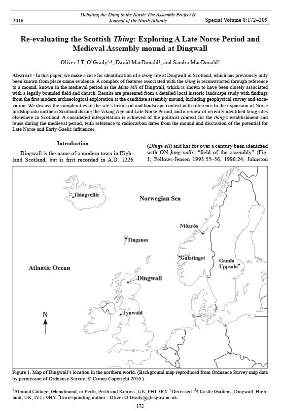
Dingwall is the name of a modern town in Highland
Scotland, but is first recorded in A.D. 1226
(Dingwell) and has for over a century been identified
with ON þing-völlr, “field of the assembly” (Fig.
1; Fellows-Jensen 1993:55–56, 1996:24; Johnston
Re-evaluating the Scottish Thing: Exploring A Late Norse Period and
Medieval Assembly mound at Dingwall
Oliver J.T. O’Grady1,*, David MacDonald†, and Sandra MacDonald2
Abstract - In this paper, we make a case for identification of a thing site at Dingwall in Scotland, which has previously only
been known from place-name evidence. A complex of features associated with the thing is reconstructed through reference
to a mound, known in the medieval period as the Mute hill of Dingwall, which is shown to have been closely associated
with a legally bounded field and church. Results are presented from a detailed local historic landscape study with findings
from the first modern archaeological exploration at the candidate assembly mound, including geophysical survey and excavation.
We discuss the complexities of the site’s historical and landscape context with reference to the expansion of Norse
lordship into northern Scotland during the Viking Age and Late Norse Period, and a review of recently identified thing sites
elsewhere in Scotland. A considered interpretation is achieved of the political context for the thing’s establishment and
reuse during the medieval period, with reference to radiocarbon dates from the mound and discussion of the potential for
Late Norse and Early Gaelic influences.
Debating the Thing in the North: The Assembly Project II
Journal of the North Atlantic
1Almond Cottage, Glenalmond, nr Perth, Perth and Kinross, UK, PH1 3RX. †Deceased. 24 Castle Gardens, Dingwall, Highland,
UK, IV15 9HY. *Corresponding author - Oliver.O’Grady@glasgow.ac.uk.
2016 Special Volume 8:172–209
Figure 1. Map of Dingwall’s location in the northern world. (Background map reproduced from Ordnance Survey map data
by permission of Ordnance Survey. © Crown Copyright 2016.)
Journal of the North Atlantic
O.J.T. O’Grady, D. MacDonald, and S. MacDonald
2016 Special Volume 8
173
1934:156; Southey 1929:118; Watson 1904:93). The
name is comparable with a small number of other
“ding” place-names found elsewhere in the British
Isles that have been identified as thing sites and
which provide additional support for Dingwall’s
identification as a thing place-name. These include
the comparable Dingieshowe, the possible Dinghill
in Leicestershire, Dingbell Hill in Northumberland,
and the historic Dingesmere, recently identified with
modern Thingwall in the Wirral, England (Baker and
Brookes 2015:6; Cavill et al. 2004:29–32; Fellows-
Jensen 1996:19, 24–25). At Dingwall the /d/ sound
is most likely to have evolved as a result of transmission
in a Gaelic linguistic context by which the
place-name was later adopted into English, as Fellows-
Jensen (1996:24) has argued, though this is unlikely
to hold true for all examples given their wide
geographical distribution (Cavill et al. 2004:29–32).
Dingwall’s association with a Norse assembly site
is undisputed based on the place-name evidence. As
a Scottish example, it is particularly interesting because
the place-name is an outlier on mainland Scotland’s
North Sea coast and lies near the presumed
southerly extent of Norse influence down the east
coast of Scotland (see Crawford and Taylor 2003).
Attempts to explain this geographical location have
been limited by a paucity of historic information for
this part of Northern Scotland during the Viking Age
and the limited archaeological information available
(see Crawford 1995, Woolf 2010:275–77). This
article seeks to address these problems by taking
a cross-disciplinary look at where exactly the site
of the Dingwall thing may have been located and
why. We undertook a detailed documentary study of
Dingwall’s local historic landscape aimed at identification
of the thing site’s location. The results of
this effort have been used to target the first archaeological
investigations at the proposed site. We then
discuss the archaeological results in combination
with a review of other thing sites and the historic and
landscape context for Northern Scotland during the
Viking Age and Late Norse Period.
Historical and Environmental Background to
the Thing
To date, the archaeology of the Dingwall thing
has received limited attention. The precise location
of the assembly site was not adequately defined.
In this article, the assemblies associated with the
Dingwall thing are assumed to have been primarily
seasonal meetings of freemen that provided judicial
organization for the surrounding region, through the
resolution of civil and criminal disputes. In this sense,
the thing could have regional or local administrative
functions, for instance to resolve property claims
for compensation or infringements of taxation. In
practice, by the end of Viking Age and into the medieval
period, the deliberative functions of the thing
could be largely dominated by higher authorities.
This model is based on studies of better-documented
things in the North Atlantic and Norway. Research in
Scandinavia has indicated that such gatherings may
have had their origins among Iron Age tribal societies
(Brink 2004, Crawford 1987:204–205, Sanmark and
Semple 2008, Storli 2010).
Since the late 19th century A.D., the main candidate
site for the thing at Dingwall was a natural
terraced hill called Gallowhill. This feature is located
on the western edge of the modern town of
Dingwall.1 Mainly based on the apparent judicial
association of the name Gallowhill, Bain (1899:45)
proposed the location’s connection with the legal
functions of a thing, and put forward the unsubstantiated
notion that the hill may have been used to
seat judges who oversaw Norse courts. Bain’s ideas
remained largely unchecked throughout the 20th
century. Most recently Crawford (1987:206–208)
highlighted the Gallowhill as a candidate site for the
thing. The place-name is indeed of interest in so far
as it does appear to have a Norse origin. Gallowhill
is recorded in a charter of 1603 as Gallibber, which
may be derived from Norwegian galgeberg, “the
gallow hill”.2 However, this place-name is clearly
indicative of a site of capital punishment and so need
not correlate with the siting of a judicial court and its
associated assembly-field. For instance, a separate
gallow-hill and thing site can be seen at Tingwall
in Shetland where the court and possible execution
site are situated 500 m apart (Coolen 2016 [this
volume]).3 This was also the arrangement at estate
centers and court-sites in other parts of medieval
Scotland and is a pattern identified in Anglo-Saxon
England (Innes 1872:97–98, O’Grady 2014:132,
Reynolds 2013).
We are putting forward an alternative site for
the Dingwall thing. The proposed location is a short
distance north of Dingwall High Street. This was the
site of a mound and level field that were located adjacent
to St. Clement’s Church, the medieval parish
church. The area has been substantially affected by
post-medieval development and land reclamation.
A reconstruction of the historic landscape using
cartographic and documentary evidence nevertheless
shows that the mound was previously located
on a small estuarine peninsula. By combining this
new landscape analysis with the results from targeted
archaeological investigation, we propose that
the mound was constructed during the 11th and 13th
centuries A.D., in the context of interaction between
Gaelic and Late Norse legal traditions. There is a
substantial amount of landscape and place-name
Journal of the North Atlantic
O. J.T. O’Grady, D. MacDonald, and S. MacDonald
2016 Special Volume 8
174
evidence to support the site’s identification, despite
extensive post-medieval redevelopment of the immediate
environs. Key to this argument will be the
notable similarities between Dingwall’s historic
landscape characteristics and other better-documented
legal assembly sites in Scotland and Norway.
Dingwall’s geographical, historical,
archaeological, and toponymical context
The modern town of Dingwall was developed
on the plan of a medieval burgh established in A.D.
1226 and is located in the historic district of Rossshire
in northern mainland Scotland (Fig. 1). Nearby
to the east is the muddy canalized mouth of the River
Peffery, at the point where it meets the head of the
tidal Cromarty Firth, which in turn provides access
to the North Sea (Fig. 2). The Scottish Gaelic name
for Dingwall is Inbhir Pheofharain (Innerpeffery),
which translates into English as the “mouth of the
River Peffery” (Watson 1904:93). Such a wellappointed
location confers on Dingwall a degree of
strategic importance. Silting of the river mouth, and
to a lesser extent post-glacial rebound, has limited
navigable access to the sea since the post-medieval
era. The settlement’s strategic importance, at least
for the medieval era, is illustrated by Dingwall Castle’s
representation as one of the main fortifications
in northern Scotland on Matthew Paris’s ca. A.D.
1250 map of Britain.4 Partial remains of the castle
are still visible in the grounds of a 19th-century A.D.
mansion near the mouth of the River Pef fery.5
The settlement is located at the eastern end of
the agriculturally fertile Strathpeffer valley and at
a short distance north from the mouth of the Canon
River, the largest river in the district (Fig. 2). Overland
routes to the east provide access to the Black
Figure 2. Map of Dingwall showing places mentioned in the text. (Background map reproduced from Ordnance Survey map
data by permission of Ordnance Survey. © Crown Copyright 2016.)
Journal of the North Atlantic
O.J.T. O’Grady, D. MacDonald, and S. MacDonald
2016 Special Volume 8
175
Isle peninsula, which divides the Cromarty Firth
from the larger Beauly Firth and the historic settlement
of Inverness, where the district of Moray lies
beyond to the southeast. Landward routes are also
available via Strathpeffer to the west coast of Scotland
by way of Strath Bran and Glen Carron. This
geographical location with its protected sea loch
(lake), good access to the North Sea, and accessibility
to natural resources would have made this an
ideal location for Norse expansionist interests in the
area from the Viking Age onwards.
Evidence for Viking activity. Norse interest in
the area is supported by the occurrence of Norse
place-names there, including Stava, Stavek (1266
A.D.), and Stavaig. These are obsolete historic
names for the lower tidal reaches of the Canon River
and were derived from ON stafr-a “stave river”
and ON stafr-vik “stave bay” (Crawford and Taylor
2003:8; Macrae 1923:152; Watson 1904:xviii–xix,
152). Partially based on this toponymic evidence,
Crawford (1986, 1995) has proposed that the area
was targeted for Norse settlement from the Northern
Islands of Scotland during the 11th century A.D.,
with the specific purpose of exploiting local timber
resources for trade and ship-building. In support of
the feasibility of this idea, there are notices of timber
shipments from vessels berthed near the shoreline at
Dingwall recorded as late as 1813. 6
Strathpeffer was also clearly an important center
of power in the Pictish era prior to the Viking Age.
A class I Pictish symbol stone is located at the Parish
Church of Dingwall. It was discovered reused
as masonry in 1875 when the church was rebuilt.
The church site dates back to at least the medieval
period, although the Pictish stone raises the possibility
for an early medieval foundation. Perhaps more
significantly for the present discussion, the church’s
dedication was to St. Clement’s, which may imply
a Norse or Danish connection with the 11th-century
A.D. seafarer’s cult (Crawford 2008:199–200). Further
to the west and overlooking Dingwall are the remains
of a hillfort at Knockfarrel. This fort was most
probably the main power center in the area until the
Viking Age, and standing nearby in the valley below
is another class I Pictish symbol stone.7 Following
Woolf’s (2006) reorientation in our understanding
of the political geography of Pictland, it has now
become apparent that Dingwall and Ross are likely
to have been located within the important Pictish
kingdom of Fortriu until the late 9 th century A.D.
This association has relevance for the current
discussion because among the earliest mentions of
Viking activity that were likely to have affected the
area around Dingwall is an entry in the Annals of
Ulster for the year A.D. 839 that recorded a decisive
military defeat of the men of Fortriu and their allies
by “the heathens”.8 The apparent scale of this event
may indicate the action of a large Viking military
campaign rather than a seasonal expeditionary force
(Woolf 2010:66). Although caused by unknown
antagonists, this battle appears to have been a
catastrophic event for the political map of northern
Britain, as Fortriu recedes in our sources from this
date. This event may also provide historical context
for the establishment of a head thing in the region by
Viking settlers, marking the reorganization of legal
traditions and subjugation of the local population.
There are ample analogies to draw on for similar
large-scale military campaigns by Danish forces in
Anglo-Saxon England during the 9th century A.D.,
which in time affected the organization of legal assemblies.
9
In contrast, a smaller-scale event is recorded
in the north for A.D. 866. The Irish annals record
a Hiberno-Norse invasion of Fortriu and Pictland
under the leadership of Amlaíb, son of the king of
Laithlind, and his brother Auisle, which only appears
to have lasted three winters (Anderson 1973:250).10
In the following years, possibly the same Amlaíb
was active in several other locations in the British
Isles and had perhaps been killed by the early
870s (Woolf 2010:107–109). The events of A.D.
866 seem unlikely to have involved the managed
creation of a stable legal assembly site at Dingwall,
though of course the thing may have been convened
before A.D. 866. By the early 10th century A.D., the
political center of Pictland had shifted southward,
away from the areas later known as Moray and Ross,
to the vicinity of Strathtay and modern Perthshire. A
general consensus has emerged among scholars that
this change was in part due to damage inflicted upon
Fortriu by Viking incursions during the 9th century
A.D. (see Woolf 2010:87–121). As with the western
Atlantic seaboard, the extent of Viking settlement
and political dominance established north of the Moray
Firth is difficult to prove, though it has obvious
implications for our understanding of the extent to
which new Norse legal practices and assembly sites
were also introduced.
There is only limited Viking archaeology in the
form of material culture and burials from Ross and
neighboring regions. No in situ Viking burials are
known from the area. Nonetheless a small, but significant
group of artifacts have been discovered in
the north of the region near the Dornoch Firth, 70
km northeast of Dingwall. This collection includes
an oval brooch found with a fragment of steatite
bowl at Ospisdale (Curle et al. 1954:238–239, PSAS
1933:20); a fragment of hack-silver from the terminal
of a ring-money bracelet found at Pitgrudy
(Hunter 2011:104); and a late-10th-century A.D. silver
hoard from Portmahomack (Miller and MacLeod
Journal of the North Atlantic
O. J.T. O’Grady, D. MacDonald, and S. MacDonald
2016 Special Volume 8
176
1889:314–317). Recent excavations at the associated
early medieval monastery at Portmahomack
have also revealed a Viking Age destruction horizon
dated to the late 8th century or early 9th century A.D.
(Carver 2008:136–139). Further north at Dunrobin
in Sutherland, discovery of an iron axe head, a ring,
and two oval brooch bases may indicate the site of
another disturbed grave or graves. Further south, a
9th-century A.D. copper-alloy Hiberno-Norse ring
pin was recently discovered by metal detecting near
Castle Stuart on the Moray Firth, and a possible
Viking horse burial is known from the Moray–Banff
border (Graham-Campbell 2004:216, 227).11 As a
group, these finds amount to a tantalizing, though
fairly limited, snapshot of Viking activity across this
extensive coastal region at the height of the Viking
Age; however, it is noteworthy that no finds are
known near Dingwall. Despite this paucity of material
information, other types of evidence do suggest
that Norse settlement had extended further south to
the Cromarty Firth.
Place-names. More generalized information
about Norse settlement in the vicinity of Dingwall
can be established from ON place-names (Crawford
and Taylor 2003, Fraser 1986, Watson 1904). Near
Dingwall, westward up Strathpeffer, is Ulladale,
which is from Ulli-dalr12 with the meaning “Ulli’s
valley”—presumably referring to a local Norse freeman
or tenant (Crawford and Taylor 2003:8, Watson
1904:100). And elsewhere, Scatwell13, in Contin
Parish ~14 km west of Dingwall, was ON skat-völlr,
“tribute or tax field” (Crawford 1986:34; Crawford
and Taylor 2003:8–9, 29; Watson 1904:149). According
to Crawford (1986:43), “scat” was a tax that
in Scotland “was exclusively associated with the
Dominion of the Earldom of Orkney”. Swordale14
to the north of Dingwall in Kiltearn parish is ON
svörð-dalr meaning “grassy sward valley”, and
nearby Katewell15 was ON kví-dalr, “sheep-pen
valley” (Crawford and Taylor 2003:8, Watson
1904:87). Notably, the Cromarty Firth region and
neighboring Black Isle demarcate the most southerly
extent of ON dalr and bólstaðr (“settlement, farm”)
with a single outlier in Morayshire to the southeast.
These place-names are compelling evidence
for local Norse nomenclature and indicate a social
context of dispersed settlement that the Dingwall
thing would have served. Nevertheless, Crawford
(1986:43) and Grant (2000:95–96), among others,
have highlighted the apparent lack of place-names
for ON ouncelands or pennylands. These terms were
land-valuation units on which payment of tax or
tribute was calculated and levied. They are found
in most other areas of Scandinavian settlement in
northern and western Scotland, which Williams has
argued resulted from an expansion of the authority
of earls from Orkney out from the Northern Isles,
under the political influence of earls Sigurd Hlodversson
and his son Thorfinnr the Mighty (Williams
and Bibire 2004:203–204). The absence of ouncelands
and pennylands from Ross may indicate that
earlier Norse settlement had been integrated into the
indigenous system of davoch land divisions. Davochs
are prevalent throughout Ross and neighboring
Moray and are closely associated with expansion of
the Kingdom of Alba and neighboring Morayshire
(Ross 2011:14–33). Crawford and Taylor (2003:10)
have alternatively reasoned that a semi-autonomous
colony is suggested by the pattern of Norse settlement
names in Ross, perhaps established under the
auspices of the Norwegian exile Kalf Arneson who
fled to Earl Thorfinn in A.D. 1035. The lack of Late
Norse land-division systems may also reflect the less
successful expansion of Norse authority into Ross
compared with Caithness, where the dominance of
the earls and later the kings of Norway was established
on a more stable and long-term basis. In this
way, Dingwall should perhaps be seen more as a
changeable border zone of Norse influence than part
of a fully settled area of control.
The thing place-name does, however, suggest the
presence of a gathering place used to resolve disputes
among these communities, however autonomous
or otherwise they may have been from comital
or royal authority. Other place-names near Dingwall
provide further topographic information about the
assembly site’s immediate environs. An example is
the place-name Broadpool, which is recorded as the
northern boundary of Walkman, a large open field, in
a Burgh sasine register for Dingwall dated to the late
17th century A.D.16 This name contains the element
pool with the meaning “harbor” or “shore”, which
is explicable as a derivation of ON pollr, “a pool”,
specifically one which at ebb of tide retained water
sufficient to float a ship. The generic component of
Broad or Brod, may derive from ON brott, braut, or
more particularly Shetland Norn brød or bröd, each
bearing that same meaning of a made way or track.
This posterior positive word-order displayed in the
place-name Broadpool is common in Gaelic, but it
was also common in medieval Norwegian into the
14th century A.D. Alongside the Broadpool boundary
ran a ditch parallel to it on its northern flank known
as the stripe of Broadpool. Taken together this implies
Broadpool may have meant “the way or road
leading to the shore”, and potentially was a track
engineered by Norse settlers through wet carseland
to reach a berthing location on the Canon estuary
previously known as the Stavek (see above). 17
The place-name Gallowhill at Dingwall has
already been mentioned. It is recorded in a charter
of 1603 as Gallibber and in burgh sasine register
Journal of the North Atlantic
O.J.T. O’Grady, D. MacDonald, and S. MacDonald
2016 Special Volume 8
177
and Moray and more than half of Scotland”. This
Sigurðr has been identified with one “Sichfrith the
Earl” mentioned in an entry for A.D. 893 in the Annals
of Ulster and was apparently active in Dublin
(Benediktsson 1986, cf. Woolf 2010:284).20 The
accuracy of the saga’s account of the annexing of
Northern Scotland has been called into question due
to problems in the lineage of individuals mentioned
in the narrative and other cross-referencing errors
within the texts (ibid). A reference in the Chronicle
of Kings of Alba to the “wasting of Pictland” may,
however, provide some historical context. This
event occurred during the reign of Domnall mac
Constantín (A.D. 889 x A.D. 900) who was killed
by “heathens” at Dunnottar in Aberdeenshire, which
might coincide with the supposed invasion by Sigurðr
and Thorsteinn (Hudson 1998, cf. translation
in Woolf 2010:122). Sigurðr is said to have died
near Oykel in A.D. ca. 892 on the Dornoch Firth. A
mound at Cyderhall (ON Sigurðar-haugr) has been
proposed as his burial site (Crawford 1986:38–40).
It may be significant that this is near to the placename
Cuthill Links, which is from Early Gaelic
comhadhail, meaning “place of assembly” (Barrow
1992:231, no. 1.1; O’Grady 2014:115).
In the Orkneyinga Saga, Thorfinnr Earl of Orkney
and son of Sigurðr Hlodvisson is also said
to have been active in northern Scotland. His exploits
apparently included holding the lordship of
Caithness and successfully invading the north of
Scotland, culminating in the unidentified battle of
Torfness against Karli Hundason. Karli has been
identified as King MacBethad mac Findláich of
Alba—the historical Macbeth (Cowan 1993:125–
126, Crawford 1987:72). However, many of Thorfinn’s
supposed exploits as described in the sagas are
not corroborated by contemporary source material,
and so the relevance of the saga’s narrative to the
history of northern Scotland during the Late Norse
period is contested (Woolf 2010:243–244, 309–310;
cf. Crawford 1995, Ross 2011:124). Woolf has argued
that Thorfinn’s legacy had been conflated with
a later earl’s career to enhance his credentials as an
eponymous ancestor for the Orcadian rulers of the
12th and 13th centuries A.D., particularly Haraldr
Maddaðarson who occupied much of northern
Scotland in the A.D. 1190s (McDonald 2003:39–40;
Woolf 2010:243–244, 283). With similar pessimistic
caveats, Njál’s Saga written in ca. A.D. 1280
and Orkneyinga Saga describe an earlier battle
in northern Scotland between Earl Sigurðr digri
(Thorfinn’s father) and two Scottish earls connected
with Moray, although the accounts do not agree on
specific details, including the location (see Ross
2011:125–126). However we choose to treat the
veracity of conflicts mentioned in the sagas, it is
entries it is variously named Gallowber of Gallowhill
(1684), Gallober (1699), Gallabir (1729),
Galloper (1742), and Galliper (1805). As discussed,
this place-name in its various recorded forms may be
derived from medieval Norwegian galgeberg, “gallows’
hill”, indicating the pairing of an execution
site with the nearby court meeting place. Gallowhill
is ~900 m west of both the medieval burgh center
and the location that we are proposing was a thing
site.
A further alleged judicial execution site that may
have early medieval pedigree can be identified 34 km
south of Dingwall at Tom Na Croiseige by Kiltarlity.
Here a stepped-mound 23 m in diameter and 3 m high
is traditionally said to have been a “seat of judgment”
where a “hanging tree” grew.18 The functionality
of stepped-mounds as assembly sites has long been
suspected based on the well-documented example at
Tynwald on the Isle of Man, with other examples at
Thingmote in Dublin, Law Ting in Cumbria (England),
and—less certain—Tinwald in Dumfriesshire
and Govan, both in Scotland (Cowper 1891; Darvill
2004; FitzPatrick 2004:28, 45–47; O’Grady
2008a:211–217; Owen and Driscoll 2011:341). The
execution association, however, may not necessarily
indicate a court site, and the age of the Kiltarlity
mound’s steps is not known. Still, it may be significant
that another stepped-mound is located a short
distance west of Dingwall at Fodderty, the site of the
medieval parish church of Fodderty (NGR NH 5130
5936). Either one of these stepped-mounds could
potentially have been a thing mound in the Hiberno–
Norse Irish Sea tradition, but in the absence of concerted
archaeological investigations at these types of
site, beyond Tynwald on Man, it is at present difficult
to advance such a case any further.19
The sagas. Exactly when Norse control may have
extended to the area later known as Ross has been a
point of considerable contention, not least because
of our reliance on problematic sagas to give anything
like a narrative history for the area during the
Viking Age and Late Norse Period. There is notoriously
little agreement about the historical value of
saga accounts relating to northern Scotland, such as
in the Landnámabók, Orkneyinga Saga, and Njál’s
Saga, texts that were mainly composed by Icelandic
authors between the late 12th and 14th centuries A.D.
(Woolf 2010:277). The main protagonists whose
careers are linked to northern mainland Scotland
were Sigurðr the Mighty, son of Eysteinn Glumra,
and Thorsteinn the Red in the late 9th century A.D.,
and Thorfinnr the Mighty, son of Sigurðr Hlodvisson,
who were both Earls of Orkney during the first
half of the 11th century A.D. Sigurðr son of Eysteinn
Glumra and Thorsteinn were said in Landnámabók
to have conquered “Caithness and Sutherland, Ross
Journal of the North Atlantic
O. J.T. O’Grady, D. MacDonald, and S. MacDonald
2016 Special Volume 8
178
mormaer of Moray, as King of Alba who died in
A.D. 1057, and possibly the career of Mael Snechta
mac Lulaich who was referred to as rí Mureb (“king
of Moray”) in his A.D. 1085 death notice.21
In this section we have aimed to provide an outline
of the geographical, historical, archaeological,
and toponymical context for Dingwall during the Viking
Age and Late Norse Period. Two key historical
periods have emerged as potentially important for
interpreting the development of the Dingwall thing:
the 9th century A.D. and the early 11th century A.D.
The information considered above will form the
basis from which to better understand the historic
significance of the thing site’s location and physical
attributes when we turn to the archaeological findings.
At this point, we will explore the detailed local
historic landscape evidence that has aided identification
of the thing site.
Identification of the Thing Site
In A.D. 1226, Alexander II chartered Dingwall
“in Ros” as a royal burgh; the medieval place-name,
as we have mentioned, indicated the prior meeting
place of a thing. Given the ON element –völlr (“a
level field”), the location of the common gathering
of the thing is likely to have been on the level valley
floor visible at the lower floodplain of the River
Peffery. The “field” element is commonly associated
with thing sites in the British Isles and North Atlantic
(Coolen and Mehler 2014, Crawford 1987:204–
210, Darvill 2004, Fellows-Jensen 1993:55–56).
A usual feature is for a core meeting-place, where
court proceedings were convened, to be located at
or beside the assembly field.22 In this section of the
article, we set out a case for the specific location of
the Dingwall thing site and advance the theory that
the site correlates with a later medieval assembly
mound, which we argue had reused the venue for the
earlier thing. The Mute hill of Dingwall was a large
earth mound that appears to have been a medieval judicial
meeting place, and was previously located on
the south bank of the River Peffery, a short distance
from Dingwall high street. The site’s topography and
landscape can be reconstructed using localized historical
and cartographic evidence. This reconstruction
will show that the site had striking similarities
with other better-known thing sites.
Identification of this site with the thing is not
a new notion, as Bain (1899:44, 103) and Watson
(1904:93), and more recently Fellows-Jensen
(1996:24), suggested that the Mute hill of Dingwall
could have been significant to the thing. However, the
precise location of Mute hill had not been proven by
previous commentators, and no thorough study of this
historic feature had been attempted (cf. Clark 1993).
apparent from reconstructed genealogies that substantial
integration had occurred between the ruling
families of the Northern Islands and mainland Scotland.
Such political integration may have extended
to other forms of integration in legal culture and
mechanisms of lordship, a subject that we will return
to below. Based on the accounts and historic references
outlined above, it is probable that the north of
Scotland had come under some form of Norse rule as
far south as Ross at some point between the late 9th
and early 11th century A.D., even if it is not possible
to reconstruct the precise longevity and details.
Late Norse period and medieval historical
records. Although fragmented, medieval records
from the Scottish perspective can also relate useful
information about the political status of Ross and
neighboring Moray during the 11th and early 12th
century. These accounts have implications for understanding
Dingwall’s importance in the Scottish Late
Norse Period. Ross was clearly a province in its own
right at least as early as ca. A.D. 1115 when an earl
Aedh appears as a witness to Alexander I’s founding
charter of the priory of Scone. The same earl Aedh
was witness in the A.D. 1120s to two early charters
of David I (Lawrie 1905:nos. 36, 74, 94). In 1157,
Malcolm MacHeth was recognized as earl of Ross
by Malcolm IV, after a period of royal confiscation
that followed a rebellion led by the mormaer (equivalent
to an earl) of Moray in 1130 (Innes 1840:151).
Records of a subsequent rebellion in Ross by the
MacWilliams during the 13th century A.D. include
mention of the “thanes of Ross” in 1211 (Skene
1871:278, ii, 274). Grant (2000) has made a case for
the existence of a thanage at Dingwall from the early
11th century A.D. If true, this thanage may have been
formed to subdue the region after annexation and to
create a bulwark of royal authority against future
incursions from the north.
Much discussion has also considered the question
of the political status of neighboring Moray during
the 10th and 11th centuries A.D., with debate centering
on whether Moray can be defined as an independent
kingdom at some point during the 11th century
A.D. This is not the place to debate further whether
it was mormaers or independent kings based in Moray
(Moréb) that held sway over large swathes of
northern mainland Scotland between Caithness and
the Cairngorms mountain range (Dumville 1997:36;
Woolf 2000, 2010:240–241; cf. Ross 2011:82–100).
Nonetheless, what is relevant for the present discussion
is that lords in Moray would certainly have had
a vested interest in maintaining control of, or nullifying,
a regional judicial center in the neighboring
province to the north; either by proxy or directly.
Key episodes that may have affected Dingwall
include the rise of MacBethad mac Findláich the
Journal of the North Atlantic
O.J.T. O’Grady, D. MacDonald, and S. MacDonald
2016 Special Volume 8
179
Relevant here is Fellows-Jensen’s (1993:64–65) conclusion
that the majority of thing place-names in Britain
indicated sites where “legal assemblies continued
to be held for centuries, even after the Scandinavian
language dropped out of use”. Conversely, recent
study of the locations for local assemblies in Viking
Age and medieval Norway have highlighted the potential
for change and complexity in the siting of local
and regional courts (Ødegaard 2013). On this basis,
it should also be borne in mind that the siting of the
thing at Dingwall may have changed over time within
the general environs.
Beyond the firm place-name evidence for the
thing reviewed above, other evidence for a historic
judicial meeting place at Dingwall comes from later
medieval historical documents. When in 1503 James
Duke of Ross resigned his lands of Ross to his brother
King James IV, it was recorded that in order to
keep his title the Duke retained the montem of Dingwall,
from the Latin meaning “mound, a small hill”,
that was described as juxta (“beside, near”) the town
(Dalrymple 1770:58).23 The mound referred to in the
1503 record was not the castle mound of Dingwall,
which was located further to the east and was a large
stone-built fortification occupied up until A.D. 1625
(NMRS site no NH55NE 4, RCAHMS 1979:30,
no. 255). The only recognizable mound that can be
identified as having stood adjacent to the medieval
burgh was a low mound that previously stood within
a walled-enclosure a short distance north of the high
street. This mound was used for the burial site of
George Mackenzie, first Earl of Cromartie, who died
in A.D. 1714. Since A.D. 1947, the enclosed area
and site of the by then levelled mound have served
as a town center car park. The title deed gained by
the first Earl of Cromartie to what would be his place
of burial was dated February 13th, A.D. 1672 and
entitled “… disposition of ye mute hill of Dingll to
Tarbatt”; Tarbatt in this case referred to Sir George
Mackenzie who was also Viscount Tarbat.24 Mute
hill is cognate with “Moot-hill” and is Scots for
“hill of assembly”; derived from Old English mōt or
gemōt with the meaning “assembly”, “meeting”, or
“encounter”. Place-names in the form mute-hill have
been revealed as a significant indicator for medieval
judicial assembly sites in Scotland, some of which
may have origins in the late first millennium A.D.
(O’Grady 2014:129–134).
The earl’s A.D. 1672 property disposition refers
to the area within which the mound was located as the
Hillyard, which indicated an enclosure surrounding
the Mute hill. The precise location of this enclosure
is described in the document as delineated by the
churchyard of Dingwall parish church on the north
and at the west by the “the co’on Calsay that leades
to the church yaird of dingll”.25 Calsay is Scots for
a stretch of paving or a paved part of a street.26 On
the east, the Hillyard was bounded by slaik, common
burgh land. Slaik is Scots for “to lick”, which in this
context refers to the licking or lapping movement
of the tide and describes land which the sea covers
at high water, in this case mudflat.27 John Bayne,
minister of Dingwall, in A.D. 1718 referred to a
“ditch or sink” which “wants a bridge … betwixt
the church and the glebe”.28 Richard Pococke, a
Church of Ireland Bishop for Ossory, noted from his
visit to Dingwall in A.D. 1760 that “to the South of
the Church is a stone enclosure in ruins but fenced
with a Ditch which is the burial place of the family
of Cromartie” (Pococke 1887). Land records of the
17th and 18th centuries A.D. indicate that the northern
boundaries of the burgh tenements of Dingwall
appear as “the slaik” or alternatively “the sea, the
floodmark, or the fludder” (cf. fløda, Shetland Norn,
“reaching high water”), except those which backed
on to the Hillyard assembly site.29 In 1684, “slaick”
formed the northern boundary of the Trinity Croft.
This feature is a large open field which is mentioned
with the Hilyaird in a royal charter of 1591.30 It
was one item amongst chaplainry lands of the Holy
Trinity and St. Michael in the burgh of Dingwall,
the superiority of which the crown granted in 1591
to one Ronald Bayne, the burgh’s commissioner to
parliament. In the charter of demission, the “Hilyaird”
is recorded as “horto”, a yard or enclosure,
pertaining to the “Trinitie-croft”.31 The Trinity Croft
is indicated on the Ordnance Survey map of A.D.
1881 as “Trinity”, a field to the immediate west of
both Church Street and the parish churchyard. The
name may come from the adjacent parish church,
one of the dedications of which is to the Holy Trinity.
This legal attachment of the Trinity Croft to the
Hillyard suggests that historically the two had been
components of a single entity. Although the evidence
is admittedly late in date, the Trinity Croft, with its
level topography and legally defined boundaries, is
an attractive candidate for an assembly field associated
with the court mound.
Also of relevance is a burgh sesine record of A.D.
1682, which records that at least one of the chaplainry
properties associated with Dingwall, Aikermichael,
had been held by the abbey of Dunfermline.32
Dingwall Parish Church, located beside the Trinity
Croft, had also remained a property of the Priory
of Urquhart in Moray until shortly before 1500.
Urquhart was a Benedictine sister house of Dunfermline.
The chaplainry properties and the church
may have been part of extensive lands bestowed
on these monasteries by David I in A.D. 1135, as
part of a reassertion of royal power in the district of
Ross, which followed the defeat of Oengus mormaer
of Moray at Stracathro in A.D. 1130 (see Ross
Journal of the North Atlantic
O. J.T. O’Grady, D. MacDonald, and S. MacDonald
2016 Special Volume 8
180
forming a variety of small islands and peninsulas
beside the town (Rose 1791:4). A representation of
this environment can be seen on two maps created
by George Brown in the A.D. 1790s (Fig. 3).33 The
Hillyard is visible as an enclosed area south of the
parish church. On each of Brown’s plans of Dingwall
is shown an island in the tidal water east of
both the church and Hillyard. In a charter of 1547,
that island is recorded as “Cruke, lying east of the
church”, and on David Aitken’s plan of “The Burgh
Lands of the Estate of Tulloch”, dated A.D. 1789,
it is named as Easter Cruik.34 In burgh records, the
island is variously recorded as Cruik, Little Cruik,
or Easter Cruik, and said to be bounded on all sides
by “the sea”. Cruik in Scots means a bend (cf. ON
krokr, “bend”). The name no doubt refers to the
pronounced southern bend in the river that enclosed
the island and which formed a tidal inlet beside the
2011:78). Even by 1157 when Malcolm IV reinstated
Malcolm MacHeth as earl of Ross, the earl was ordered
to “protect the monks of Dunfermline and all
that was theirs in the time of King David” (Barrow
1960:222, no. 179). On this basis, royal confiscation
of the assembly site at Dingwall may have been a
conscious part in this political strategy to effectively
nullify the judicial center that would have been an
important apparatus of lordship in the region. This
could also mean that the site had a ceremonial importance
for the mormaers of Ross in the early 12th
century A.D., perhaps as an inauguration site?
The historic landscape of the site can be further
reconstructed by a reference in A.D. 1787 to their
having also been “Slake … at the east and north of
the Church” (Minutes of Dingwall Town Council,
2 October, A.D. 1787). In addition, in 1791 the
lower tidal waters of the river were described as
Figure 3. Extract from a plan of intended road from Lochcarron to Achnasheen and thence to Dingwall surveyed in 1793 by
George Brown. © Crown Copyright: National Records of Scotland (Ref. No. RHP 11597 and 11591).
Journal of the North Atlantic
O.J.T. O’Grady, D. MacDonald, and S. MacDonald
2016 Special Volume 8
181
mound site. Based on this evidence,
the Mute hill mound should be understood
to have occupied a small peninsula,
which extended northwards into
the lower tidal waters of the River
Peffery.
From the early 19th century A.D.
onwards, this historic estuarine landscape
was progressively obscured.
This process began with the canalization
of the river under the direction
of Thomas Telford during A.D.
1815–1817. The resulting changes
and reclamation of land can be seen
on A.D. 1821 maps by Telford and
John Wood (Figs. 4, 5). On Wood’s
map, the mound is visible within
the Hillyard enclosure south of the
parish churchyard, a short distance
north of the town. The Trinity Croft
field is a blank area immediately west
of the mound across Church Street.
An early photograph from the A.D.
1880s shows the Trinity Croft still in
Figure 5. Plan of the Town of Dingwall, surveyed by John Wood in 1821. The Mute hill mound is visible labelled as the
“Earl of Cromarty’s Memorial”. © National Library of Scotland.
Figure 4. Extract from Telford’s plan of Dingwall Canal. Commission for Highland
Roads and Bridges Eighth Report 1821.
Journal of the North Atlantic
O. J.T. O’Grady, D. MacDonald, and S. MacDonald
2016 Special Volume 8
182
use for farming beside the church of St. Clement’s.
The mound is out of view behind buildings to the
right (Fig. 6). This picture again illustrates the close
proximity of the historic mound, church, and field.
This relationship is illustrated clearly on another late
19th-century A.D. map of the area (Fig. 7).
The mound was the subject of an antiquarian
excavation in A.D. 1875, which sought to confirm
Figure 6. The Trinity Croft in the A.D. 1880s. Courtesy Dingwall Museum Trust.
Figure 7. Extract from Ordnance Survey 1st edition 6-inch map of Ross-shire and Cromartyshire, Sheet LXXXVIII, surveyed
A.D. 1873 and published A.D. 1881. © National Library of Scotland.
Journal of the North Atlantic
O.J.T. O’Grady, D. MacDonald, and S. MacDonald
2016 Special Volume 8
183
the exact location of the Earl of Cromartie’s burial
place, a basic account of which was recorded by
Fraser (1876:clxxv). The excavation does not appear
to have been undertaken with awareness that
the site had once been an assembly mound. Based
on Fraser’s description of the excavation, this was an
unscientific and exploratory event. Nonetheless, the
drawings that Fraser made of the Earl’s 18th-century
tomb are valuable as the only archaeological record
of the mound prior to its levelling, though these
reveal little about the mound’s composition or appearance
(Fig. 8).
Two photographs from the early 20th century
show the mound prior to its levelling in A.D. 1947
(Fig. 9). These show a low turf-covered mound with
gradual slopes spread within the Hillyard’s enclosure
wall. After World War II, the mound site was used as
a town center car park and renamed the Cromartie
Memorial Car Park. This involved levelling of the
mound in A.D. 1947 using a bulldozer, and resurfacing
of the site with tarmac (Figs. 10, 11).35 The
neighboring Trinity Croft field was used as the site
of an agricultural auction market for much of the
20th century until 2003 when redevelopment of the
site for a supermarket and petrol station took place.
Prior to this, archaeological works for development
management purposes took place on Church Street
and at the site of the former auction market. Twelve
trenches 1250 m2 in area were excavated across
the site of Trinity Croft up to the western border of
Church Street, but no archaeological deposits were
encountered; the natural substrate was confirmed as
a sticky grey clay (Cook 2003). If
the Trinity field was indeed the site
of the popular thing assembly, unfortunately
it appears unlikely that
significant archaeological remains
have survived in this area. Despite
this result, there was still potential
for the mound site to contain significant
archaeological remains.
New archaeological investigations
directed by Oliver O’Grady were
therefore targeted at the Cromartie
Memorial Car Park. As this section
has detailed, this location can now
be appreciated as the site of the
historic Mute hill of Dingwall, and
its historic landscape setting on an
estuarine peninsula, with the adjacent
field and church, is a strong
candidate for the central meeting
place of the thing site. Details from
the results of the new archaeological
investigations will now be described.
Archaeological Investigation
The investigations were undertaken
during 2011–2012. This
project began with a ground penetrating
radar (GPR) survey that
was aimed at assessing the extent
to which archaeological remains of
the mound and adjacent estuarine
shore had survived beneath the car
park. The survey helped to confirm
the presence of extensive and
complex archaeological remains,
including heavily truncated basal
deposits of the mound; as well as
Figure 8. Illustrations from an excavation at the Earl of Cromartie’s burial place
on the Mute hill in 1875 (Fraser 1876:clxxiv–clxxv).
Journal of the North Atlantic
O. J.T. O’Grady, D. MacDonald, and S. MacDonald
2016 Special Volume 8
184
post-medieval building remains, in particular on the
southern side of the site. The location of the historic
shoreline of the peninsula on which the mound was
positioned was also revealed. Based on these results,
a single trench was excavated across the north
side of the mound. This was intended as a means of
verifying the geophysical results, but also sought to
recover material culture and dating evidence that
Figure 9. Photograph (top) taken from the north in the early 20th century A.D. that shows the Mute hill mound in the Hillyard
with the town behind. Photograph (bottom) taken from the southeast during demolition of the mound in 1947. Courtesy
Dingwall Museum Trust.
Journal of the North Atlantic
O.J.T. O’Grady, D. MacDonald, and S. MacDonald
2016 Special Volume 8
185
Figure 10. The Cromartie Memorial Car Park at Dingwall viewed from the south. Note the low rise in the car park’s topography
that indicates the mound site. © Oliver J.T. O’Grady.
Figure 11. Topographic contour plan of the mound site (10-cm–contour separa tion).
Journal of the North Atlantic
O. J.T. O’Grady, D. MacDonald, and S. MacDonald
2016 Special Volume 8
186
Figure 12. Interpretive plan of radar timeslice anomalies.
could help understand the function
and chronological development
of the mound. Although
no Viking Age material culture
was recovered, an important
sequence of radiocarbon dates
support that the mound was a
man-made monument and created
around the mid-11th century
A.D. during northern Scotland’s
Late Norse Period. The excavation
also revealed that the mound
was constructed from redeposited
clays during at least two,
potentially three, separate phases
of construction, the first around
the mid-11th century and latter
possibly during the 12th–13th century.
We first describe the results
from the geophysical survey and
then provide a summary of the
excavation findings.
Geophysical survey
The GPR survey was undertaken
across the area of the car
park and over adjacent road surfaces
at Church Street and Tulloch
Street. The equipment used
was an Utsi GV3 single channel
400 MHz central frequency antenna.
A timeslice survey was
recorded across the entire interior
of the car park using a line
separation of 0.5 m, sample resolution
of 14.75 mm, and a 60 ns
time sweep. Single radar profiles
were recorded to the north and
west of the car park (O’Grady
2011a:5–6).36 The timeslice survey
revealed the historic extent
of the mound and the reclaimed
estuarine shoreline as a strip
of homogeneous disturbance
around the north and east side of
the car park (Figs. 12, 13). The
base of the mound was registered
as a coherent oval-shaped zone
of interfaces approximately 45
m north to south and 39 m west
to east (Figs. 12, 13). Anomalies
10 m–15 m wide across the north
and south of the car park were
interpreted as areas of reclaimed
tidal inlets. This finding suggestJournal
of the North Atlantic
O.J.T. O’Grady, D. MacDonald, and S. MacDonald
2016 Special Volume 8
187
Figure 13. GPR timeslice plots from the mound site.
ed that a channel up to 3 m deep bordered the site to
the north. The perimeter of the peninsula shoreline
appeared uneven. This may reflect the historic layout,
but areas of possible truncation and ground disturbance
particularly at the north and northeast may
also account for the irregular plan (Figs. 12, 13).
Journal of the North Atlantic
O. J.T. O’Grady, D. MacDonald, and S. MacDonald
2016 Special Volume 8
188
More substantial disturbance was evident to
the south. This area correlated with the location of
buildings that stood here during the 19th century
A.D. (Figs. 12, 13). Modern service trenches were
also evident as were areas of disturbance probably
related to reduction of the mound in 1947 (Figs. 12,
13). Part of a possible causeway or neck of land that
connected the peninsula to the area of Trinity field
was evident at depth as a distinct zone of interfaces
on the southwest side of the site (Figs. 12, 13). Several
anomalies across the body of the mound indicated
structures and areas of disturbance. For instance,
a large rectangular anomaly indicated the site of a
stone wall that previously enclosed the center of the
mound (Figs. 12, 13). This anomaly, which was later
confirmed by excavation, relates to an 18th-century
A.D. burial enclosure. Further post-medieval burial
activity and Victorian excavations were indicated
by irregular areas of disturbance around a modern
memorial garden that now occupies the center of
the mound. The garden was not surveyed due to the
likelihood of extensive modern disturbance and the
limited available space in this area (Figs. 12, 13; cf.
Fraser 1876:clxxv). A single radar profile recorded
across the west side of the site provided a complete
section through the in-filled tidal inlet that previously
surrounded the side of the mound (Fig. 14).
The radar results informed the positioning of an
excavation trench across the northwest side of the
site, where modern disturbance appeared least, and
the results of which will now be described.
Excavated evidence
A trench 2 m wide and 20 m long was opened
across the northwest side of the car park (Fig. 15).
This excavation aimed to characterize the mound’s
composition, the stratigraphic relationship with the
old shoreline and peninsula (Fig. 16), and to investigate
a series of smaller anomalies identified by the
radar. A summary of the excavated sequence will
now be given (cf. O’Grady 2012). 37
Modern layers of made-up ground were revealed
beneath the tarmac and overlay the remnant slope of
the mound (Fig. 17). Other post-medieval features
included remains of the Hillyard’s enclosure wall
and the foundations of the modern memorial garden
wall at the southeast end of the trench. This wall was
cut into the clay of the mound. A rectangular enclosure
identified in the radar survey was revealed as a
mortared section of wall-footings across the middle
of the trench (Fig. 18). This feature appears to have
been an enclosure wall and surrounded the Earl of
Cromartie’s burial memorial that was built into the
mound around A.D. 1714 (O’Grady 2012:5–7).
At the northwest side of the trench, estuarine
muds were revealed as a purplish dark brown clay
containing sand, mollusc shells, charcoal flecks,
post-medieval pottery, and animal bone. The mud
was explored to a depth of 1.5 m, though the base
was not located. To the southeast, near the mound,
this deposit overlay layers of sandy clays and was interpreted
as the last estuarine muds to have been laid
down by the action of tidal water prior to land reclamation
during the 19th century A.D. (010; Figs. 19,
20). A slot was excavated through the interface between
the estuarine muds and the edge of the mound
(Fig. 21). The outer slope of the mound overlays a
further estuarine mud that in turn itself overlays an
earlier berm of the mound. Northwest of this slope,
the estuarine mud went down onto a compact peat
(O’Grady 2012:7–8). This deposit of peat with clay
lenses sloped down to the northwest and was shown
Figure 14. GPR profile T6.
Journal of the North Atlantic
O.J.T. O’Grady, D. MacDonald, and S. MacDonald
2016 Special Volume 8
189
to overlay the lower edge of a light-brownish grey
sandy clay, which appeared to form part of the lower
deposits of the mound (Fig. 21). Radiocarbon dates
from the upper and lower mound layers indicated
that the intervening estuarine mud was deposited
between the 11th and 13th century A.D. (Fig. 22). This
finding was supported by two redware medieval pottery
sherds from the intervening mud that date to the
late 12th or 13th century A.D. (O’Grady 2012:49; G.
Haggarty, National Museum of Scotland, Edinburgh,
UK, pers. comm.). This is crucial evidence that the
last phases of the Mute hill’s construction occurred
during the medieval period and may relate to a later
remodelling of the assembly mound.
The 18th-century A.D. enclosure wall mentioned
above truncated the upper strata of the mound and in
doing so had created an artificial division between
the stratigraphy to the southeast and northwest (Fig.
23). To the north side of the wall, the truncated remains
of the mound’s outer edge were visible as a
low slope. This deposit was a compacted band of
dark-brown silty clay (012; Fig. 23). Medieval pottery
was recovered from the surface of the deposit and
a fragment from the rim of an iron vessel. This layer
was interpreted as the man-made remains of the outer
surface of the mound. This feature may have formed
a berm around the edge of the mound, but more likely
has simply been truncated by modern demolition
and originally covered the entire surface. Medieval
pottery from the underlying deposits and radiocarbon
dates (SUERC-45299 Corylus, SUERC-45300
Figure 16. Stratigraphic matrix.
Figure 15. Plan of trench location.
Journal of the North Atlantic
O. J.T. O’Grady, D. MacDonald, and S. MacDonald
2016 Special Volume 8
190
Corylus) indicate that this outer level was created no
earlier than the late 12th century A.D. and no later than
the 17th century A.D. The layer of estuarine mud beneath
the outer mound deposit extended a short level
distance beyond it to the northwest giving the impression
of a small step (Fig. 23). This feature probably
marked the limits of the tidal shoreline around the
mound (O’Grady 2012:8).
An earlier band of the mound’s construction
material was revealed as a bluish-grey clay. This
deposit was truncated by the 18th-century A.D. enclosure
wall and formed a compacted layer containing
flecks of charcoal, exposed to a depth of 0.49 m.
Beneath this, a firm light-brownish-grey sandy clay
formed a thick band containing patches of ironoxide
and charcoal flecks. Radiocarbon dates from
Figure 17. Southwest-facing section showing demolition layer (0 02) above estuary mud (010).
Figure 18. Pre-excavation photograph of wall [004] looking nort heast.
Journal of the North Atlantic
O.J.T. O’Grady, D. MacDonald, and S. MacDonald
2016 Special Volume 8
191
the interface of the outer mound deposits and bands
of layers in the mound beneath the cut of the postmedieval
enclosure wall indicate that this part of the
mound was created at some point before 1029–1220
cal AD (95.4%, SUERC-45300, Corylus) and after
980–1164 cal AD, though this date was derived from
a long-lived tree species (95.4%, SUERC-45298,
Pinus; Fig. 24; O’Grady 2012:8–9).
Two further bands within the mound, in the
form of dark grey clay, were revealed beneath the
post-medieval enclosure wall cut. These deposits
sloped down to the northwest and appeared to curve
round from the north to the southwest (021 and 022;
Figs. 23, 25). Charcoal retrieved from these bands
returned calibrated radiocarbon dates of 1046–1275
cal AD (95.4%, SUERC-45297, Corylus) and 980–
1164 cal AD (95.4%, SUERC-45298, Pinus; Figs.
22, 24). The comparatively thin width of these bands
may suggest that they formed historic surface material
for a smaller mound, earlier in date, though no
turf-lines were evident. On this basis, the overlaying
thicker mound deposits could potentially indicate
Figure 19. Pre-excavation estuary mud (010) with mound
deposits visible beyond looking southeast.
Figure 20. Pre-excavation plan of trench with (010) and [004] i n situ.
Journal of the North Atlantic
O. J.T. O’Grady, D. MacDonald, and S. MacDonald
2016 Special Volume 8
192
Figure 21. Northeast-facing section of slot excavated at the ed ge of the mound and estuary muds.
Figure 22. Radiocarbon dates from (011) SUERC-45299 (GU30198) and
(022) SUERC- 45297 (GU30196).
successive expansions, augmentations,
or maintenance of the monument at intervals
between the 11th and 13th century
A.D. (Fig. 23; O’Grady 2012:9).
The remaining interior mound material
was composed of re-deposited sandy
clays that were bluish grey and mottled
with orange, changing to orange-grey
further into the mound (Figs. 23, 26).
These were mixed deposits containing
nodules of clay, loam patches that may
be decayed turf, charcoal, and iron panning.
We interpreted the color change
evident across these deposits as the
result of the slow leaching of brackish
water through the outer bands of the
mound. Radiocarbon dating and the
mixed content confirmed that these were
man-made deposits used to raise the
core of the mound. A band of firm grey
sandy clay at the base of these deposits
returned a calibrated radiocarbon date,
sourced from charcoal, of 1056–1281
calAD (95.4%, SUERC-45301, Betula;
Fig. 27; O’Grady 2012:9).
A 0.5-m sondage was excavated
below this clay, revealing a thin crust of
iron panning overlying a band of black/
dark brown clay with occasional charcoal
fragments (possibly an old ground
surface) below which was the natural
substrate. This was a clean clay colored
grey, turning brown-white, and comparable
with a similar deposit located
below the edge of the mound to the
Journal of the North Atlantic
O.J.T. O’Grady, D. MacDonald, and S. MacDonald
2016 Special Volume 8
193
Figure 23. Southwest-facing section of the trench excavated thr ough the mound and estuary muds.
northwest, and the nearby natural clay identified
by a previous excavation to the west of the site
(Fig. 23; O’Grady 2012:9–10, cf. Cook 2003:4).
A further calibrated radiocarbon date from above
the interface of the natural substrate gave the result
1017–1207 cal AD (95.4%, SUERC-45296,
Corylus; Fig. 28). This level was interpreted
as the natural clay of the peninsula formed by
glacial-fluvial action on the local Braemore
Mudstone Formation, a mixture of mudstone,
sandstone, and limestone sedimentary deposits
formed approximately 398 to 407 million years
ago during the Devonian Period.38 The excavation
was halted at this stage (Figs. 29 and 30).
Interpretation: phasing
The results of the excavation can now inform
an initial interpretation of the mound’s phasing,
though it is of course appreciated that any model
is restricted by the limitations of the evidence. It
is also anticipated that what is proposed here may
be refined by further paleo-environmental analysis
and future larger-scale excavation.
Phase I: Mid 11th–Late 12th century A.D. (Late
Norse thing?/Early Gaelic Mute hill?). A natural
headland, possibly earlier used as part of a thing
site and located amongst a muddy inlet at the
lower tidal reaches of the River Peffery estuary,
was adapted by the raising of a large earth mound
at some point between the latter half of the 11th
century A.D. and late 12th century A.D. This phase
encompassed the deposition of several layers of
re-deposited clays to create the central body of
the mound, the outer edges of which extended out
over existing estuary mud deposits. Thin bands
of clay through the center of the mound indicate
where an original surface may have been. These
deposits were overlain by a further thick layer
which may imply that the monument was added
to or adapted on at least one occasion during
this period, or may have been created through a
process that involved staged construction. The
closely ranged sequence of radiocarbon dates,
however, make it difficult to differentiate such
details in the chronology. If there was not the
physical evidence for phasing between the outer
surfaces, these dates could in fact be used to support
a single construction event for the majority
of the mound. There is a small possibility that this
period may have coincided with Norse incursion
into Ross during the first half of the 11th century
A.D. and construction of a thing mound under the
aegis of the Earls of Orkney, but on balance the
radiocarbon dates suggest a later event that in fact
represented the re-appropriation of the thing field
Journal of the North Atlantic
O. J.T. O’Grady, D. MacDonald, and S. MacDonald
2016 Special Volume 8
194
and peninsula by the construction of a large court
mound at the Norse meeting-place, perhaps under
the orders of a resurgent earl of Ross, or a powerful
mormaer of Moray such as MacBethad mac Findláich,
or a representative of the Kingdom of Scots.
Phase II: High medieval (Mute hill). From approximately
the late 12th century A.D to the 13th century
A.D., the mound was augmented with the addition
of a new surface deposit or berm. This activity
followed an extended period during which there was
a build-up of estuary mud around the confines of the
site. This phase was potentially related to the use of
the site as a medieval judicial assembly mound that
would eventually become associated with the development
of the Scots nomenclature for the site in the
place-name Mute hill, but was probably established
under Gaelic lordship
associated with the
rulers of Ross and Moray.
This phase may
also be associated with
increased assertion of
Scottish royal power
in the district, perhaps
linked to a thanage and
certainly with the establishment
of a royal
burgh. Medieval pottery
and an iron vessel
were deposited on
the mound during this
phase, perhaps simply
by occasional losses
associated with the
nearby settlement or
feasibly from encampments
near the site by
delegates attending
judicial assemblies.
From this phase the
general appearance of
the mound during the
lifetime of the medieval
burgh of Dingwall
had taken shape,
assuming that the lost
upper form of the
mound was not further
augmented.
Phase III: Postmedieval
(mausoleum).
This phase was
associated with the
end of the site’s function
as a place of judicial
assembly, and
with the mound’s reuse
as a burial ground for
the Mackenzie family
during the 17th–18th
century A.D., which
appropriated the site’s
historic significance.
Figure 24. Radiocarbon dates from the base of (011) SUERC-45300 (GU30199) and the interface
of (021) SUERC-45298 (GU30197).
Journal of the North Atlantic
O.J.T. O’Grady, D. MacDonald, and S. MacDonald
2016 Special Volume 8
195
During this period, the rectangular enclosure wall
was probably built around A.D. 1714 to surround the
burial mausoleum of the 1st Earl of Cromartie. The
final estuary muds were also deposited around the
site during this phase, at which time midden material
of animal bone and pottery was dumped into the area
from the adjacent town. The channel of the tidal inlet
had become largely silted-up before wholesale land
reclamation followed canalization of the River Peffery
between A.D. 1815 and A.D. 1817. From this
point, the site became increasingly marginalized and
took on the status of a local curiosity, largely owing
to the memorial stone obelisk that stood on the summit
of the mound.
Phase IV: 20th century A.D. (car park). This was
the destruction phase of the site, when in A.D. 1947
Figure 25. Northeast-facing section showing dark clay band (021 ) and clay (009).
Figure 26. Part of the southwest-facing section with details of mixed clays (008), (009), and (016).
Journal of the North Atlantic
O. J.T. O’Grady, D. MacDonald, and S. MacDonald
2016 Special Volume 8
196
Figure 27. Radiocarbon dates from (019) SUERC-45301 (GU30200).
Figure 28. Radiocarbon dates from interface of (018) with (020) SUERC-45296 (GU30195).
Journal of the North Atlantic
O.J.T. O’Grady, D. MacDonald, and S. MacDonald
2016 Special Volume 8
197
the mound was levelled and the car park created to serve the modern
town. The memorial garden wall, still visible at the center of the car park,
was also created at this time. The site had taken on its present form, and
its historical significance was largely forgotten.
Conclusions: archaeological investigation
Although limited in scope, these archaeological investigations
have confirmed for the first time the presence of important
archaeological remains relating to the assembly mound, and have also
Figure 30. Post-excavation view across the trench looking south east.
Figure 29. Post-excavation plan of trench.
Journal of the North Atlantic
O. J.T. O’Grady, D. MacDonald, and S. MacDonald
2016 Special Volume 8
198
shown for the first time that this was a man-made
monument created at some point between the mid-
11th century A.D. and late 12th century A.D. (Fig.
31). These are significant discoveries and make this
site one of only a few purpose-built court mounds
to have been excavated in the British Isles to date
(see Adkins and Petchey 1984; cf. Mallett et al.
2012, O’Grady 2008b, Sanmark and Semple 2008).
The Mute hill of Dingwall is also the first court
mound in Scotland to have been scientifically confirmed
as constructed during the medieval period
(see O’Grady 2014). The identification of apparent
phasing and adaptation in the mound’s construction
is also a significant finding, despite that it is
not possible to clarify the dating of this sequence
with complete precision. We discuss the possible
implications of this phasing in greater depth below.
Identifying the site as a thing based purely on the archaeological
remains also has difficulties. The lack
of material culture pre-dating the 12th century A.D.
is one factor, although absence of finds from the
truncated interior of such a relatively simple monument
is perhaps not entirely unexpected. The limited
size of the excavation is another potential issue.
Beyond the place-name evidence, which is good,
several characteristics of the archaeology—such as
the general lack of significant occupation deposits,
the nearby and clearly separate castle mound, the
close association with a field and church, and the
apparent lack of medieval or earlier burials—do
nevertheless provide circumstantial support for the
interpretation of the site as an assembly mound,
if not a thing mound. Earlier burials on the peninsula
could have been destroyed by Victorian activity
around the center of the site, but nevertheless such
use would not preclude a later assembly function.
Furthermore, an 11th-century burial mound would be
extremely unusual in Scotland. Even with the complications
of reasoning from negative evidence, the
creation of such an extensive monument is difficult
to explain in the setting of 11th–12th century Scotland
other than as some form of assembly mound. This
reasoning becomes particularly clear if we take into
account the Norse and Scots place-name evidence
and the historical context of contested Norse and
Scots governance in Ross during this period, which
could have influenced such a monumental statement
of power and governance.
The relative archaeological sterility of the
mound’s clays also need not be problematic. For
instance, the Secklow hundred mound, excavated
in 1977–1978, was composed of simple turf and
soil and lacked material culture associated with the
site’s use as an assembly site (Adkins and Petchey
1984:246–250). That study also illustrated how the
lack of remains can make court mounds difficult to
date and how such features could be constructed into
the medieval period. Another important outcome of
the Dingwall excavation is that the results have discounted
the notion that the site and peninsula may
have been located beneath sea level in ca. A.D. 1000.
Further paleo-environmental research into historic
ocean levels along the Cromarty Firth coast and the
extent of glacial rebound will help to refine this finding.
More information about the site’s environs and
construction will also be forthcoming from paleoenvironmental
analysis of bulk soil samples and
thin-section samples taken during the excavation
Figure 31. Calibrated radiocarbon dates from the Mute hill.
Journal of the North Atlantic
O.J.T. O’Grady, D. MacDonald, and S. MacDonald
2016 Special Volume 8
199
that are to be published elsewhere. Nonetheless, it
is clear from these initial findings that a substantial
amount of man-power and effort would have been
required to create a monument on the scale of the
Dingwall Mute hill, at 38 m by 48 m, which in plan
is around half the size of the royal mound at Scone.
In simplified terms, the large size of the mound, and
the substantial marshalling of manpower required to
create it, would seem in keeping with the establishment
of a major regional center for legal organization.
But can we reconstruct further the political and
historical context for creation of this extraordinary
monument? The final part of the article will consider
these questions based on our reasoned understanding
of the site’s development and historic landscape
with a new review of recent research into thing sites
found elsewhere in Scotland.
Scottish Thing Sites
Since Fellows-Jensen’s (1993, 1996) pivotal survey,
six new thing place-names have been identified
in Scotland. All of these are in the Western Islands
of Scotland, on the Hebridean islands of Bute, Islay,
Mull, Eigg, and Lewis. Edin on Bute (Atyng’ar 1475,
Iding 1577) is possibly derived from ON althing (“a
regional or head assembly”) or ON eið and ON
þing “isthmus-assembly”, and associated with an
enclosed mound, Cnoc an Rath in Borgadale. This
name contains ON borg “fort, dome-shaped hill” and
dalr “valley” (Duffy 2011; Markus 2012a:8, 2012b;
O’Grady 2011b). Sunderland on Islay in Kilchoman
parish is possibly from ON *Sjóvarþing, “the assembly
place by the lake”, which Macniven identified
with a prominent and flat-topped natural mound
overlooking Loch Gorm (Caldwell 2008:333; Macniven
2006:363, 364, fig. 74, 365). Whyte has recently
refuted Macniven, opting instead for a cairn at
nearby Grulin, ON grjót and ON þing “stony thing”.
Whyte has suggested a similar interpretation for the
place-name Gruline on the Isle of Mull that is located
near a large flat-topped stony mound, and also
for Grulin on the Isle of Eigg (Whyte 2014:117–119,
139–147). In the Outer Hebrides, Eilean Thinngartsaigh
is a small and uninhabited rocky island off the
south coast of Lewis in Loch Claidh39 and is thought
to contain a thing element (B. Crawford, School of
History, Univesity of St. Andrews, Fife, Scotland,
UK, pers. comm.). Also on Lewis is Toingal that
can be linked to a small hill in Uig parish (Cox
1991:484). More tentatively, Maeshowe chambered
cairn on Orkney has been proposed as a thing due to
the unusual concentration of runic inscriptions at the
site and the heightening of the surrounding bank and
central mound during the Viking Age. Kirkwall, also
on Orkney, has been identified as a thing, though
mostly based on saga evidence (Graham-Campbell
and Batey 1998:42, 61). This small group of new
sites provide a valuable expansion on the 11 examples
established by Fellows-Jensen and previously
known from the Shetland Islands (Jakobsen 1993,
cf. Sanmark 2013). These additions bring the total to
22 thing place-names from Scotland (Fig. 32). The
landscape form of these sites are not all the same,
which as we shall see, is probably also true of their
historical development.
In addition to the aforementioned group, Owen
and Driscoll (2011) have recently repeated a case
for Norse influence in the development of an assembly
mound at Govan in central Scotland, the
lost “Doomster Hill”. Over the last two decades,
several published articles have assigned Govan a
prominent position in the established literature on
Scottish assembly sites and Norse influence therein
(see Driscoll 1998, Owen and Driscoll 2011:345).
This prominence in itself would require us to consider
Govan in more detail, though there is no Norse
place-name at Govan40 and the archaeology of the
Doomster Hill’s remains largely unknown, but some
of the interpretive reasoning used to link Govan to
Norse influence has particular relevance for our discussion
of Dingwall. This is perhaps not the place
for an extended critique of Owen and Driscoll, but
it is nevertheless worthwhile to briefly review the
main strands of evidence put forward for Govan’s
Norse association. The Doomster Hill does not
survive, and as such, former discussion has focused
on associated circumstantial evidence at the nearby
church and comparison with other sites, in particular
Tynwald Hill on the Isle of Man (Owen and Driscoll
2011:342). A radiocarbon date spanning the early 8th
to late 9th century A.D. was derived from within a
surfaced road at the historic entrance to the nearby
churchyard. This finding was interpreted as evidence
for a “ceremonial route” between the church
and mound, and was suggested as comparable with
arrangements at the Tynwald Hill and St. John’s
church on the Isle of Man (ibid:340–341). Deposits
indicating industrial activity were also uncovered.
The burial ground, mound and a purported royal
residence on the opposite bank of the Clyde were
proposed as part of a “power center”; this model
was alluded to again in a recent article with little
further qualification (Driscoll 2016:74, 79, 89). The
Doomster Hill was also argued to have a ditch and
stepped flanks. This was based on interpretation
of an 18th-century A.D. illustration of the site, and
again compared with Tynwald Hill and 3 other possible
stepped-mounds in the Irish sea zone at Dublin,
Cumbria, and perhaps Dumfriesshire (Darvill
Journal of the North Atlantic
O. J.T. O’Grady, D. MacDonald, and S. MacDonald
2016 Special Volume 8
200
2004:229, fig. 10.6; O’Grady 2008a:211–217; Owen
and Driscoll 2011:341, fig. 7).41 A narrative for the
site’s Norse affiliation was also proposed around the
record of a raid by Dublin Vikings in 870 A.D. on
Dumbarton Rock, a major fortress of the Northern
Britons on the River Clyde estuary.42 The associative
evidence of five hogback grave-markers located at
Govan’s old parish church has also been crucial to
the Doomster Hill case. Linked on stylistic grounds
to northern England, the Govan hogback monuments
form part of a larger collection at the site of 10thcentury
cross-slabs and free-standing crosses. The
cultural implications of the hogback monuments’
artistic connections have recently undergone significant
revision and remain in contention (O’Grady
2003, Ritchie 2004, Williams 2015; cf. Driscoll et al.
2005).
Recent research into assembly sites and early
medieval church settlements elsewhere in Scotland
can support an alternative view, which we argue
raise some complications for Owen and Driscoll’s
(2011:343) assertion that “a high status Norse-style
thing place” existed at Govan. We would not refute
that wider comparisons with sites in other parts of
the British Isles and in Scandinavia is worthwhile,
as we have suggested for Dingwall, but we do contest
that Govan should foremost be understood in
relation to patterns of early medieval archaeology
in Scotland. For instance, new research has shown
that the pairing of churches and assembly mounds
was a particularly common aspect of early medieval
assembly mounds and hills in Scotland (O’Grady
2014). Prominent examples include the Bishop’s
Hill by Dunkeld Cathedral, Tillydrone Hill by
St. Machar’s Cathedral in Aberdeen, Mortlach in
Banffshire, and Moothill located beside the Abbey
of Scone (ibid:114, 116–117, 119–122, 123–125).
Such links between church and assembly sites were
known to a lesser extent in parts of Scandinavia and
Tynwald on the Isle of Man (Brink 2003, Darvill
2004). Sanmark (2013:104) has also noted that a
key feature of thing sites in Shetland is closeness to
churches, though some of these chapels may be medieval,
and the exact relationship between the sites
has not been verified. The larger group of churches
and assembly sites are, however, mostly evidenced
in mainland Scotland and suggest a separate development
in northern Britain. The Dingwall and
Govan assembly mounds cannot therefore be solely
considered as developing under Norse hegemony on
the basis of proximity to a church, but alternatively
may be related to developments elsewhere in Scotland
in areas outside of Norse political dominance.
Secondly, although it was asserted that there is
“no evidence at all” for a monastery at Govan (Owen
and Driscoll 2011:334), the significant concentration
Figure 32. Map of thing sites in Scotland. (Background map reproduced from Ordnance Survey map data by permission of
Ordnance Survey © Crown copyright 2016.)
Journal of the North Atlantic
O.J.T. O’Grady, D. MacDonald, and S. MacDonald
2016 Special Volume 8
201
of sculpture at the church is a feature almost exclusively
seen in Scotland at important early medieval
monasteries and major church settlements, such as
Iona (RCAHMS 1982), St. Andrews (RCAHMS
1933:237–239), Portmahomack (Carver 2008), and
Fortingall (O’Grady 2013, Robertson 1997), among
others, an exception being the small burial ground at
Cladh a’Bhile, Argyll (Gondek 2006). Moreover the
metalled roadway or “ceremonial route” uncovered
at Govan church has its only comparators in Scotland
in recent excavations at church settlements,
such as the kerbed roadway at Portmahomack, the
metalled entrance road at Fortingall, and the wellknown
“road of the dead” at Iona (Carver 2008,
O’Grady 2013, RCAHMS 1982). The radiocarbon
date for the Govan road is also open to reinterpretation.
The date range overlaps the 870 A.D. raid
by around only 20 years and it may be significant
that the sample was derived from a deposit that the
excavator described as a “repair” in the road (Owen
and Driscoll 2011:340–341). It would seem reasonable
to conclude that the road was in use prior to
recorded Viking incursion into Strathclyde. Could
this route way simply have formed part of the established
layout and ceremonial space of a larger
church settlement? Though this would be late for
a flourishing early medieval monastic settlement
in Scotland, this revision would not preclude the
existence of a larger royal church-settlement at Govan,
comparable to the klosterpfalzen or “monastic
palace” of Germany and Late Anglo-Saxon England
(cf. Woolf 2010:313), and not out of place among
other 10th–11th century Scottish royal centers such as
Dunfermline and Scone. The arrangement of church
and mound is in keeping with the wider pattern of
Scottish judicial assembly sites (see O’Grady 2014),
which is unlikely to have wholly derived from Norse
influences and implies the close role of Church authorities
in the development of early law in Scotland.
This interpretation would not require a Norse explanation
for the creation of the Doomster Hill. A more
nuanced reading of the evidence seems advisable, in
particular given the interplay of British, Norse, and
early Gaelic influences on late 1st millennium AD
Govan (see Macquarrie 1994). The mutability and
propensity for reuse and adaptation of assembly sites
is increasingly understood as an important process
(O’Grady 2014, Sanmark and Semple 2008). Assembly
sites could be redeveloped and adapted and
enhanced relatively late into the 11th century, as we
have seen in the excavated evidence for the Dingwall
mound, but they could also incorporate earlier
places as at Tingwall, Shetland (see above). Such
factors of reuse and appropriation could be relevant
for understanding the Doomster Hill and potential
for Norse assimilation of the site in the late 9th century
A.D., but at present it is not possible to confirm
the extent that these factors play a role there.
It is essential that theories exploring the development
of assembly sites are elucidated with excavation
data, particularly because it is apparent that assembly
sites can have unusually complex histories.
For instance, though admittedly the evidence is limited,
a stricter reading of the post-medieval records
and place-names seems to indicate that the Doomster
Hill may have been some form of reused burial
mound, perhaps prehistoric (Davidson-Kelly 1994;
NSA 1834–1845:v.6, 690; OSA 1791–1799:v.14,
294). In the absence of further excavations, this must
remain one of several possibilities, but this material
should not be wholly discounted and reminds us of
the potential complexity of site biographies. The
name “Doomster” indicates that the mound was used
as a court hill during the late medieval period, as is
also suggested with the Dingwall Mute hill. Driscoll
(2004) has asserted that Viking traditions may have
affected the wider development of assembly mounds
in Scotland, even at important royal sites such as
the Moothill at Scone. This conclusion, however,
seems premature as the current excavated archaeological
evidence provides little support for this idea.
Instead, the implications from landscape and placename
evidence suggest that Govan formed part of a
common grouping of early medieval churches and
assembly mounds found elsewhere in lowland and
northeast Scotland. On this basis, Driscoll’s view of
incoming Norse traditions is also at odds with the
wider evidence for parallel traditions of assembly
mounds and hills found across northern Europe, including
in particular, though not exclusively, Anglo-
Saxon England, Ireland, Scandinavia, and Scotland
(Gleeson 2016 [this volume]; O’Grady 2008a, 2014;
Reynolds 2013; Sanmark and Semple 2008). The
question of whether these traditions developed from
earlier expressions of power and monumentality
centered around burial mounds or required external
influences needs further urgent research (see Fitz-
Parick 2004, Semple 2004).
In order to adequately advance assembly studies
in Scotland, there is a clear imperative for future
research to source firm archaeological data from
clearly documented sites, which can then be used to
inform more meaningful broader interpretation of
this site-type. Such efforts will help to reduce our
current reliance on comparisons with other traditions
and better known sites from outside Scotland.
An admirable recent example of a conscientious
scientific study is Coolen and Mehler’s (2014) explorations
at Tingwall, Shetland. Their study has
illustrated the potential complexities of landscape
Journal of the North Atlantic
O. J.T. O’Grady, D. MacDonald, and S. MacDonald
2016 Special Volume 8
202
reuse at North Atlantic thing sites. Our explorations
at Dingwall also illustrate that it is possible to derive
meaningful archaeological information from sites
that are located in modern urban landscapes substantially
affected by recent development. These two
key studies also highlight the importance of methodologies
that incorporate detailed local historical research
with well-planned campaigns of geophysical
surveys prior to attempting excavation at assembly
sites (O’Grady 2011a, 2012). Future GPR survey
work at Govan could still yield more useful results.
Govan aside, our focus here is on the types of locations
and sites associated with thing place-names
in Scotland, as these will have important implications
for interpretation of the Dingwall mound. No
full consideration of the group’s archaeology has so
far been undertaken (cf. Crawford 1987:204–210,
Whyte 2014). Where sites can be identified, mounds
are the most common and include 8 possible thing
mounds, not counting the Dingwall Mute hill (Fig.
32). However, a closer look reveals important distinctions
in the different types of mounds that make
up the group. At least two internal types can be isolated.
The first are prehistoric mounds, either settlement
mounds or burial monuments, which include 3
sites focused around Orkney and the adjacent Caithness
coast or 5 if Maeshowe and Grulin on Islay
are included.43 These sites appear to include turfcovered
remains of Iron Age brochs, large dry-stone
built towers, which pre-dated the Viking Age. The
only excavation in the wider group at Tingwall on
Shetland has also uncovered evidence for Iron Age
occupation at the island (Coolen and Mehler 2014),
but most of the dating of these mounds is admittedly
based only on interpretation of the surface remains.44
Nevertheless, these prehistoric mounds imply a dependency
on the appropriation of existing landscape
features for the siting of thing assemblies, as may
have been the case at Govan, and presumably during
the settlement of the Northern Isles from the 9th century
A.D. onwards. In this sense, the two natural hill
sites can also be included with this group.45 There are
also indications of possible site adaptation, such as
at Thing’s Va in Caithness, where the broch-mound
is associated with a possible enclosure and nearby
turf-covered cairn, and at Maeshowe as mentioned
above.46 Such sites may also indicate the selection of
landscape features by Viking elites who still adhered
to pagan cult beliefs and legal observance, in which
pre-Christian ideas about the association of burial
mounds with supernatural powers and royal ancestry
may have played an important role (see Ellis 1977).
The second group cannot be so well defined—
again due their poor survival and inconsistent
topography—but in general terms these comprise
simpler mounds, which in some cases may have
been created for the purposes of assembly during
the Viking Age.47 The ambiguous earthwork called
the Cnoc an Rath on the Isle of Bute, which is possibly
linked to the thing place-name Edin, was set
within a landscape of prehistoric monuments and
apparently surrounded by a ditch and bank. Recent
excavation at the site initially proved inconclusive
due to post-medieval disturbance. However, recent
post-excavation analysis has provided 2 radiocarbon
dates from a preserved surface at the site that returned
calibrated dates of the 7th to 9th century A.D.,
which may suggest Viking Age activity at the site
associated with assemblies (P. Duffy, Brandanii Archaeology,
Rothesay, Isle of Bute, UK, pers. comm.;
O’Grady 2011b). At Tinwald in Dumfriesshire,
geophysical survey has provided a preliminary indication
that the candidate mound may have had a
stepped profile, but this detail remains unclear due to
the site’s use as a later motte castle during the high
medieval period. An alternative site for the thing is
Tinwald Downs, a level plain more in keeping with
the völlr “field” place-name, where military musters
and horse races were held up to the 19th century A.D.
(O’Grady 2008a:211–216). The flat-topped cairn or
mound at Gruline on Mull may also be relevant here
(Whyte 2014:117–119). Again obtaining a coherent
archaeological data set for the group is a key priority
for future research.
As the only purpose-built mound so far verified
in Scotland, it is difficult to set the Dingwall
mound in context with other sites in the Atlantic
north. Nevertheless, the propensity for mounds and
mound-like hills at other thing sites that were linked
to þing-völlr place-names could provide circumstantial
comparative basis on which to accept the
Dingwall Mute hill as a reused thing mound.48 On
the other hand, mounds and particularly hills are also
very common amongst assembly sites linked to early
Gaelic or Scots place-names in other parts of Scotland,
and throughout England and wider northern
Europe (O’Grady 2014, Reynolds 2013, Sanmark
and Semple 2013). The mound site-type can therefore
not be used alone to argue that the Dingwall
mound was created by Norsemen. This is also true
of the association of assembly mounds with early
church sites, because, as discussed above, this is a
feature found in Scotland and to some extent also in
Scandinavia (Brink 2003, O’Grady 2014). Whether
this is a shared feature of legal cultures in the Northern
World during the Viking Age or reflects pan-
European influence by the Church in early medieval
judicial organization beyond royal centers is not as
yet fully understood (see O’Grady 2014:113–117,
119–123, 131).
Journal of the North Atlantic
O.J.T. O’Grady, D. MacDonald, and S. MacDonald
2016 Special Volume 8
203
Dingwall’s landscape can also be compared
more widely with other thing sites. The Mute hill’s
location at the head of a peninsula with direct access
to water route-ways and a close-by freshwater
supply within a centrally located and fertile valley
are also landscape attributes found at the Shetland
lawting in the parish of Tingwall. Recent excavation
at the island has revealed a natural feature previously
used for late prehistoric settlement (Coolen
and Mehler 2014). Though admittedly the Law Ting
Holm lacks direct coastal access, this shortcoming
is made up for by the site’s centrality within the
Shetland archipelago, and the general similarities
in landscape characteristics, nonetheless, remain
striking with Dingwall. Even more closely matched
with Dingwall’s landscape is the important thing
site at Nidaros (Trondheim) on the Trondheimsfjord
in Norway that was known as the Eyraþing.
At Nidaros, the thing was located on a strand at the
mouth of the River Nid. This location was close
by the trading center and settlement established in
A.D. 997 on a wide bend in the river from which
the settlement takes its name. Adjacent is St. Olaf’s
cathedral founded in A.D. 1031, with its palace complex
and medieval inauguration site associated with
the cult of St. Olaf (Øystein 2014; E. Øystein, Nidaros
Cathedral Restoration Workshop, Trondheim,
Norway, pers. comm.). Similarly the Gulatinget
thing, established in the early 10th century A.D., was
sited on a field and natural outcrop at an accessible
coastal location near the mouth of the Sognefjord in
southwest Norway (Brink 2003). These key regional
thing sites from the Norse homeland provide useful
comparative exemplars from which to interpret the
proposed thing complex at Dingwall with its field
and church. It is notable though that none of these
three examples of important things included an assembly
mound. Was the Dingwall thing sited based
on a model with these pre-eminent and regionally
important sites in mind? If so was the assembly
mound added subsequently and was this done under
the aegis of Norse or Scottish authorities? Perhaps
by the mid-11th century A.D., such a difference could
be indistinguishable in the archaeological record
because of the close similarities between traditions
of legal assembly on mounds in northwest and northeast
Scotland?
The continued use of Tingwall in Shetland into
the 16th century A.D. also provides a context within
which to understand the apparent extended use of
the Mute hill at Dingwall into the medieval period.
Athough in the case of the district of Ross this usage
would have been within the jurisdiction of Scots
Common Law rather than the authority of the Kingdom
of Norway as in the north. Such longevity into
the late medieval period was also a feature of judicial
assembly sites more widely in the Kingdom of Scots
(O’Grady 2014:119, 126, 131). We also need to factor
in sufficient time to have elapsed prior to the 13th
century A.D. for the active thing place-name to have
stabilized at Dingwall. On balance, it would seem
more likely that the thing was already established
at Dingwall prior to the creation of the mound from
the 11th century A.D. The parallel Scandinavian and
Scottish traditions of assembly mounds therefore
leave us with an interpretive choice. The construction
of the mound can thus either be seen as a final
attempt to assert Norse authority, by creating a more
impressive monumental statement at the site or, perhaps
more likely, a reassertion of authority by the
lords of Ross who were drawing on an established
motif of Gaelic legal organization and lordship, and
which potentially was also meant to reference the
“royal” Moothill at Scone. As a means of concluding
the article, we will now draw together our findings
to reflect on the most likely historical context for the
creation of the Dingwall Mute hill and the implications
this has for understanding Scottish thing sites
more generally.
Conclusion: A Late Norse or Early Gaelic
Assembly Mound?
This article has set out to achieve a more accurate
understanding of the thing site at Dingwall, which
had previously only been known from place-name
evidence. Our intentions were to better understand
the precise location of the assembly site, its historic
landscape, and archaeological remains. In the absence
of direct historic evidence, a lead candidate
has been proposed in the mound known in medieval
records as the Mute hill of Dingwall. Based on comparative
analysis of the landscape with other thing
sites, thorough reconstruction of the site’s topography
by detailed documentary research, and archaeological
field investigations, we have made a case for
creation of the site as an assembly mound around the
mid-11th century A.D. How though should this construction
date be understood in the political context
of Late Norse Period northern Scotland? We have
reasonably proposed several possible scenarios,
though the limitation in our evidence means that no
one argument can be put forward as the definitive
explanation, particularly in the absence of Norse
material culture from the site.
On the one hand, if we accept that at least some
form of large-scale and politically motivated military
assault, or assaults, were made on Caithness
and Ross by Norse earls during the first half of the
11th century A.D., then this would seem an attractive
Journal of the North Atlantic
O. J.T. O’Grady, D. MacDonald, and S. MacDonald
2016 Special Volume 8
204
context in which to explain the creation of a new
and impressive legal administrative site such as the
Mute hill mound. There are strategic and geopolitical
characteristics of the site that also make this a
plausible suggestion. Dingwall and the Cromarty
Firth mark a key border zone between Morayshire
in the south and the important nexus of routeways
centered on Strathpeffer that provide access
between the west coast of Scotland and the North
Sea. This border-zone concept was also supported
by place-name evidence for the southerly extent of
Norse settlements on the east coast, which falls on
the Cromarty Firth–Black Isle line. Moreover, the
notion of Christian Late Norse earls establishing a
power base at Dingwall is circumstantially supported
by the presence of a church foundation beside the
mound site linked to the cult of St. Clement, a cult
which has strong connections to early Scandinavian
Christian observance in the 11th century A.D. (see
Crawford 2008). The establishment of a new Norse
church foundation at Dingwall could also be seen
as an attempt to usurp the traditional ecclesiastical
center of the region at Rosemarkie, located at the
eastern tip of the Black Isle, 38 km east of Dingwall
(Woolf 2006; cf. Crawford 1995), and compliments
the idea of the creation of a new power center. Finally
the close similarities of Dingwall’s landscape
characteristics to other important thing sites in the
Norwegian homeland and in the Shetland Islands
suggest that the site may have been created with
these existing models in mind by protagonists who
were familiar with such sites. However, as noted
above, these comparators lack assembly mounds. On
the other hand, the landscape characteristics and siting
on a coastal peninsula are features rarely found in
combination at early medieval assembly sites further
south in mainland Scotland (O’Grady 2014). Based
on these factors, a Norse agency can be argued for
convening of the thing in the 11th century A.D, and
possibly associated with the traditions of incursions
made by the Earls of Orkney into northern Scotland
during this period, but not necessarily in the creation
of the mound. This interpretaion would of course not
preclude the possibility that a thing may have been
first sited at the headland or nearby field site as part
of Viking conquest in the area during the 9th century
A.D. and before the creation of the mound.
Given the doubt cast over the saga evidence,
it would be imprudent to put forward a named
candidate for the individual behind the creation or
re-establishment of the thing, even if we accept the
above scenario and despite the obvious temptation to
bestow this honor on Thorfinn the Mighty of Orkney.
Indeed it is the nuanced interaction of Late Norse and
Scottish interests at Dingwall that can inform a more
compelling interpretation of the assembly mound. It
is clear that by the first decades of the 12th century
A.D. the region of Ross and presumably Dingwall
were under the lordship of mormaers of Ross and not
under Norse control. This chronology would seem
to imply that either the use of the mound for a thing
was only short-lived as a focus for Norse legal organization,
perhaps only for a generation, or that Norse
annexation of the area was not sustained during the
11th-century A.D.. The former might explain the
apparent lack of a developed system of ounceland
divisions in the area. If the latter, then it might be
possible that the assembly mound was in fact created
by a mormaer of Ross to reassert judicial authority
in the region, drawing on contemporary early Gaelic
assembly practices within the Kingdom of Alba
(see O’Grady 2014). The phased construction of the
mound between at least the 11th and 13th centuries
A.D. could also be associated with augmentation of
the site following reassertion of Scottish royal authority
in the area. Such an event might also fit into
the much-debated attempts made by the mormaers
of Moray to assert their sovereignty during the 11th
century A.D. The implication of this interpretation
is that we accept that the thing had been an existing
institution which pre-dated the mound’s creation,
perhaps either sited on the natural peninsula where
the mound was later created or at the nearby level
plain of the Trinity field. If we favor this model, then
the possible period for establishment of the thing
may have followed the devastation of Fortriu in
the 9th century A.D. The radiocarbon dates from the
mound certainly do not sustain with any certainty a
pre-11th century construction date, and although the
physical evidence for phasing is good, the date-span
for the 6 radiocarbon dates between the mid-11th to
late-13th century A.D. makes more detailed interpretation
inadvisable. There is a clear need for more
excavated examples of assembly sites in Scotland
to compare with the currently singular results from
the Dingwall mound, and future studies should seek
to investigate and recover dating evidence from a
larger sample of assembly mounds. Future GPR survey
and excavation in the area of Trinity Field may
also reveal evidence for the thing. Nonetheless, with
this article, we have made a significant contribution
by presenting the first archaeological evidence for
a purpose-made assembly mound in Scotland. We
have substantially increased understanding of the
structural and chronological development of the
Mute hill of Dingwall, and highlighted historic landscape
features important for the study of thing sites
in Scotland.
Journal of the North Atlantic
O.J.T. O’Grady, D. MacDonald, and S. MacDonald
2016 Special Volume 8
205
Acknowledgments
This article is based on research by the authors for the
Dingwall Thing Project, which was supported by funding
grants from the Society of Antiquaries of Scotland, Hunter
Archaeological and Historical Trust, and Strathmartine
Trust. The authors wish to express their grateful thanks
for funding received from the THING Project (funded
by the EU Northern Periphery Programme 2007–2013),
The Highland Council and Dingwall History Society in
support of archaeological excavation at the Cromartie
Memorial Car Park in Dingwall. We are also grateful to
The Highland Council for giving access permission to the
car park for the purposes of fieldwork. The thinking which
underpins the ideas presented in this article was developed
independently by Oliver O’Grady during research for his
doctoral thesis and by David and Sandra MacDonald during
local research for the Dingwall History Society. The
resulting article is the outcome of the authors’ subsequent
collaborative research. Sincere thanks to Alexandra Sanmark
for the invitation to contribute to this volume and
for the diligent work of the editor and anonymous reviewers.
Any errors within remain the authors. This article is
dedicated to the late David MacDonald, who passed away
during the editorial process.
Abbreviations
NSA 1845. The new statistical account of Scotland: By the
ministers of the respective parishes, under the superintendence
of a committee of the society for the benefit
of the sons and daughters of the clergy. W. Blackwood
and Sons, Edinburgh, UK.
OSA Sinclair, J. (Ed.) 1791–1799. The [old] statistical
account of Scotland: Drawn up from the communications
of the ministers of the different parishes. W.
Creech, Edinburgh, UK.
Literature Cited
Adkins, R.A., and M.R. Petchey. 1984. Secklow hundred
mound and other meeting-place mounds in England.
Archaeological Journal 141:243–251.
Anderson, M.O. 1973. Kings and Kingship in Early
Scotland. Scottish Academic Press, Edinburgh, UK.
310 pp.
Bain, R. 1899. History of the Ancient Province of Ross.
The Pefferside Press, Dingwall, UK. 480 pp.
Baker, J., and S. Brookes. 2015. Identifying outdoor assembly
sites in early medieval England. Journal of
Field Archaeology 40.1:3–21.
Barrow, G.W.S. 1960. Regesta Regum Scottorum Vol. 1.
Edinburgh University Press, Edinburgh, UK. 339 pp.
Barrow, G.W.S. 1992. Scotland and its Neighbours in the
Middle Ages. Hambledon Press, London, UK. 255 pp.
Benediktsson, J. 1986. Íslendingabók, Landnámabók. Hiđ
Íslenzka Fornritafélag, Reykjavík, Iceland. 525 pp.
Brink, S. 2003. Legal assemblies and judicial structure
in early Scandinavia. Pp. 61–72, In P.S. Barnwell and
M. Mostert (Eds.). Political Assemblies in the Earlier
Middle Ages. Studies in the Early Middle Ages 7.
Brepols, Turnhout, Belgium. 213 pp.
Brink, S. 2004. Legal assembly sites in early Scandinavia.
Pp. 205–216, In A.Pantos and S. Semple (Eds.). Assembly
Places and Practices in Medieval Europe. Four
Courts Press, Dublin, Ireland. 256 pp.
Caldwell, D. 2008. Islay the Land of Lordship. Birlinn,
Edinbugh, UK. 320 pp.
Carver, M.O.H. 2008. Portmahomack: Monastery of the
Picts. Edinburgh University Press, Edinburgh, UK.
240 pp.
Cavill, P., S. Harding, and J. Jesch. 2004. Revisiting
Dingesmere. Journal of the English place name society
26(October 2004):25–38.
Clancy, T.O. 1996. Govan: The name. Annual report of the
society of friends of Govan old 6:2–3.
Clark, A. 1993. Vikings in Ross and Cromarty: Fact and
Fantasy. Museums Section of Ross and Cromarty District
Council Leisure Services, Dingwall, UK.
Cook, M. 2003. Tesco, Dingwall Action Mart site:
Archaeological works data structure report. AOC
Archaeology Group. Unpublished report. Available
online at http://her.highland.gov.uk/hbsmrgatewayhighland/
DataFiles/LibraryLinkFiles/9581.pdf. 11 pp.
Coolen, J., and N. Mehler. 2014. Excavations and Surveys
at the Law Ting Holm, Tingwall, Shetland. An Iron
Age Settlement and Medieval Assembly Site. BAR
British Series 592. Archaeopress, Oford, UK. 135 pp.
Cowan, E.J. 1993. The historical Macbeth. Pp. 117–142,
In W.D.H. Sellar (Ed.). Moray: Province and People.
Scottish Society for Northern Studies, Edinburgh, UK.
264 pp.
Cowper, H.S. 1891. Law ting at Fell Foot, Little Langdale,
Westmorland. Transactions of the Cumberland and
Westmorland Antiquarian and Archaeological Society
11:1–6.
Cox, R.A.V. 1991. Norse-Gaelic contact in the west of
Lewis: The place-name evidence. Pp.479–493, In P.
Sture Ureland and G. Broderick (Eds.). Language
Contact in the British Isles. Proceedings of the Eighth
International Symposium on Language Contact in
Europe, Douglas, Isle of Mann, 1988. M. Niemeyer,
Tübingen, Germany. 717 pp.
Crawford, B.E. 1986. The making of a frontier: The Firthlands
from 9th–12th centuries. Pp. 33–46, In R.J. Baldwin
(Ed.). Firthlands of Ross and Sutherland. Scottish
Society for Northern Studies. Edinburgh, UK. 220 pp.
Crawford, B.E. 1987. Scandinavian Scotland. Leicester
University Press, Leicester, UK. 280 pp.
Crawford, B.E. 1995. Earl and Mormaer: Norse-Pictish
Relationships in Northern Scotland. Groam House,
Rosemarkie, UK. 30 pp.
Crawford, B.E. 2008. The Churches Dedicated to St.
Clement in Medieval England. A Hagio-geography
of the Seafarer’s Saint in 11th-century North Europe.
Scripta Ecclesiastica 1. Axioma, St. Petersburg, Russia.
237 pp.
Crawford, B.E., and S. Taylor. 2003. The southern frontier
of Norse settlements in North Scotland place-names
and history. Northern Scotland 23:1–76.
Curle, A.O., M. Olsen, and H. Shetelig. 1954. Viking Antiquities
in Great Britain and Ireland. Civilisation of
the Viking Settlers in Relation to Their Old and New
Countries 6. Aschehoug, Oslo, Norway. 251 pp.
Journal of the North Atlantic
O. J.T. O’Grady, D. MacDonald, and S. MacDonald
2016 Special Volume 8
206
Dalrymple, D. 1770. The Additional Case of Elisabeth,
Claiming the Title and Dignity of Countess of Sutherland,
by her guardians. Unknown publisher, London,
UK. 177 pp.
Darvill, T. 2004. Tynwald Hill and the “Things” of power.
Pp. 217–233, In A. Pantos, and S. Semple (Eds.). Assembly
Places and Practices in Medieval Europe. Four
Courts Press, Dublin, Ireland. 256 pp.
Davidson-Kelly, T.A. 1994. The Govan collection in the
context of local history. Pp. 1–19. In A. Ritchie (Ed.).
Govan and its Early Medieval Sculpture. Alan Sutton
Publishing Limited, Stroud, UK. 168 pp.
Driscoll, S.T. 1998. Church archaeology in Glasgow
and the kingdom of Strathclyde. The Innes Review
49.2:95–114.
Driscoll, S.T. 2004. The archaeological context of assembly
in early medieval Scotland: Scone and its
comparanda. Pp. 73–94, In Pantos, A., and S. Semple
(Eds.). Assembly Places and Practices in Medieval
Europe. Four Courts Press, Dublin, Ireland. 256 pp.
Driscoll, S.T.D. 2016. Reading Govan Old: Interpretative
challenges and aspirations. Pp. 73–92, In F. Hunter
and A. Sheridan (Eds.). Ancient Lives: Objects,
People, and Place in Early Scotland. Essays for David
V Clarke on his 70th birthday. Sidestone Press, Leiden,
The Netherlands. 382 pp.
Driscoll, S.T., O.J.T. O’Grady, and K. Forsyth. 2005. The
Govan school revisited: Searching for meaning in the
early medieval sculpture of Strathclyde. Pp. 135–158,
In S. Foster and M. Cross (Eds.). Able Minds and
Practised Hands. Society for Medieval Archaeology,
Leeds, UK. 434 pp.
Duffy, P. 2011. Cnoc an Rath, Argyll, and Bute (North
Bute parish): geophysical survey and excavation.
Discovery and Excavation in Scotland New 12:52–53.
Dumville, D.N. 1997. The Churches of North Britain in
the First Viking Age. Friends of the Whithorn Trust,
Whithorn, UK. 38 pp.
Ellis, H.R. 1977. The Road to Hel: A Study of the Conception
of the Dead in Old Norse Literature. Reprint of
1943 edition. Greenwood Press, Westport, CT, USA.
208 pp.
Fellows-Jensen, G. 1993. Tingwall, Dingwall, and Thingwall.
North-Western European Language Evolution
21/22:53–67.
Fellows-Jensen, G. 1996. Tingwall: The significance of
the name. Pp. 16–29, In D.J. Waugh (Ed.). Shetland’s
Northern Links: Language and History. Scottish Society
for Northern Studies, Edinburgh, UK. 256 pp.
FitzPatrick, E. 2004. Royal Inauguration in Gaelic Ireland
c. 1100–1600. A Cultural Landscape Study. Studies
in Celtic History XXII. Boydell, Woodbridge, UK.
294 pp.
Fraser, I. 1986. Norse and Celtic place-names around
the Dornoch Firth. Pp. 23–32, In R.J. Baldwin (Ed.).
Firthlands of Ross and Sutherland. Scottish Society
for Northern Studies, Edinburgh, UK. 220 pp.
Fraser, W. 1876. The Earls of Cromartie: Their Kindred,
Country, and Correspondence. I/II. Thomas and Archibald
Constable, Edinburgh, UK. 720 pp.
Gleeson, P. 2015. Kingdoms, communities, and Óenaig:
Irish assembly practices in their Northwest European
context. Journal of the North Atlantic Special Volume
8:33–51.
Gondek, M. 2006. Early Historic Sculpture and Landscape:
A case study of Cladh a’Bhile, Ellary, Mid-
Argyll. Proceedings of the Society of Antiquaries of
Scotland 136(2006):237–258.
Graham-Campbell, J. 2004. “Danes … in this country”:
Discovering the Vikings in Scotland. Proceedings
of the Society of Antiquaries of Scotland
134(2004):201–239.
Graham-Campbell, J., and C.E., Batey. 1998. Vikings in
Scotland: An Archaeological Survey. Edinburgh University
Press, Edinburgh, UK. 296 pp.
Grant, A. 2000. The province of Ross and the kingdom of
Alba. Pp. 88–126, In E.J. Cowan and R.A. McDonald
(Eds.). Alba: Celtic Scotland in the Middle Ages.
Tuckwell Press, East Linton, UK. 282 pp.
Hudson, B.T. 1998. The Scottish chronicle. Scottish Historical
Review 77:129–161.
Hunter, F. 2011. Pitgrudy, Highland (Dornoch parish),
metal detector find. Discovery and Excavation in Scotland,
New 12:104.
Innes, C. 1840. Liber Cartarum Sancte Crucis. Bannatyne
Club, Edinburgh, UK. 333 pp.
Innes, C. 1872. Lectures on Scotch Legal Antiquities. Edmonston
and Douglas, Edinburgh, UK. 326 pp.
Jakobsen, J. 1993. The Place-names of Shetland. Facsimile
of 1936 edition. Orcadian, Kirkwall, UK. 273 pp.
Johnston, J.B. 1934. Place-names of Scotland. 3rd Edition.
John Murray, London, UK. 335 pp.
Lawrie, A.C. (Ed.). 1905. Early Scottish Charters Prior to
1153. MacLehose, Glasgow, UK. 515 pp.
Macniven, A. 2006. The Norse in Islay. Ph.D. Dissertation.
University of Edinburgh, Edinburgh, UK. 550 pp.
Macquarrie, A. 1994. The historical context of the Govan
stones. Pp. 27–32, In A. Ritchie (Ed.). Govan and its
early medieval sculpture. Alan Sutton Publishing Ltd.,
Stroud, UK. 168 pp.
Macrae, N. 1923. The Romance of a Royal Burgh: Dingwall’s
Story of a Thousand Years. North Star Proprietors,
Dingwall, UK. 391 pp.
Mallett, L., S. Reddish, J. Baker, S. Brookes, and A.
Gaunt. 2012. Community archaeology at Thynghowe,
Birklands, Sherwood Forest. Transactions of the
Thoroton Society of Nottinghamshire 116:53–72.
Markus, G. 2012a. From goill to gall-ghàidheil: Scandinavian
settlement in Bute. Pp. 1–16, In Ritchie, A. (Ed.).
Historic Bute: Land and People. Scottish Society for
Northern Studies, Edinburgh, UK. 162 pp.
Markus, G. 2012b. The Place-Names of Bute. Shaun Tyas,
Donington, UK. 624 pp.
McDonald, R.A. 2003. Outlaws of Medieval Scotland,
Challenges to the Canmore Kings, 1058–1266. Tuckwell,
East Linton, UK. 202 pp.
Miller, H., and D. MacLeod. 1889. Notice of the discovery
of a hoard of silver penannular armlets and coins
at Tarbat, Ross-shire. Proceedings of the Society of
Antiquaries of Scotland 23:314–317.
Journal of the North Atlantic
O.J.T. O’Grady, D. MacDonald, and S. MacDonald
2016 Special Volume 8
207
O’Grady, O.J.T. 2003. An interdisciplinary re-evaluation
of the early medieval sculptured crosses of the
Glasgow area. M.Phil. Dissertation. University of
Glasgow, Glasgow, UK. 90 pp.
O’Grady, O.J.T. 2008a. The setting and practice of openair
judicial assemblies in medieval Scotland: A multidisciplinary
study. Ph.D. Dissertation. University of
Glasgow, Glasgow, UK. 649 pp.
O’Grady, O.J.T. 2008b. Tracing the medieval royal centre
at Scone. Medieval Archaeology 52:376–378.
O’Grady, O.J.T. 2011a. Dingwall viking thing project:
Cromartie memorial car park, Dingwall, Highland.
Report on geophysical survey: Ground penetrating
radar. Unpublished report. Available online at https://
glasgow.academia.edu/OliverOGrady. 33 pp.
O’Grady, O.J.T. 2011b. Cnoc an Rath, St Colmac’s, Isle of
Bute,. Report on geophysical survey: Electrical resistance.
Unpublished report. Available online at https://
glasgow.academia.edu/OliverOGrady. 23 pp.
O’Grady, O.J.T. 2012. THING project: Cromartie memorial
car park, Dingwall, Highland. Archaeological
excavation: Data structure report. Unpublished
report. Avialable online at http://her.highland.gov.
uk/hbsmrgatewayhighland/DataFiles/LibraryLink-
Files/273653.pdf. 50 pp.
O’Grady, O.J.T. 2014. Judicial assembly sites in Scotland:
Archaeological and place-name evidence of the Scottish
court hill. Medieval Archaeology 58:110–142.
Ødegaard, M. 2013. State formation, administrative areas,
and thing sites in the Borgarthing law province, southeast
Norway. Pp. 42–62, In Sanmark, A., F. Iversen,
N. Mehler, and S. Semple (Eds.). Debating the Thing
in the North I: The Assembly Project. Journal of the
North Atlantic special volume 5. Eagle Hill Publications,
Steuben, USA. 124 pp.
Øystein, E. 2014. St. Olav and the Octagon of Nidaros Cathedral
in Trondheim: A Nordic Martyrion? Archaeologiam
et Artium Historiam Pertinentia XXVII(N.S.
13):139–160.
Owen, O., and S. Driscoll. 2011. Norse influence at Govan
on the Firth of Clyde, Scotland. Pp. 335–348, In
S. Sigmundsson (Ed.). Viking Settlements and Viking
Society: Papers from the Proceedings of the Sixteenth
Viking Congress, Reykjavík and Reykholt, 16–23
August 2009. University of Iceland Press, Reykjavik,
Iceland. 511 pp.
Pococke, R. 1887. Tours in Scotland. Scottish History
Society, Edinburgh, UK. 375 pp.
Proceedings of the Society of Antiquaries of Scotland
(PSAS). 1933. Donations to and purchases for the
museum and library with exhibits. Proceedings of the
Society of Antiquaries of Scotland 68:1–26.
Reynolds, A. 2013. Judicial culture and social complexity:
A general model from Anglo-Saxon England. Pp.
699–713, In A. Reynolds and K.P. Smith (Eds.). The
Archaeology of Legal Culture. World Archaeology
45.5. Routledge, Oxford, UK. 144 pp.
Ritchie, A. 2004. Hogback gravestones at Govan and beyond.
The Society of Friends of Govan Old, Glasgow,
UK. 11 pp.
Robertson, N.M. 1997. The Early Medieval Carved Stones
of Fortingall. Pp.133–148, In D. Henry (Ed.) The
Worm, the Germ, and the Thorn: Pictish and Related
Studies Presented to Isabel Henderson. Pinkfoot Press,
Balgavies, UK. 190 pp.
Rose, D., Rev. 1791. Parish of Dingwall. Pp.1–20, In
J.A. Sinclair (Ed.). Statistical Account of Scotland.
3. London. Available online at http://stat-acc-scot.
edina.ac.uk/sas/sas.asp?action=public. Accessed 30
July 2014.
Ross, A. 2011. The Kings of Alba c.1000–c.1130. Birlinn,
Edinburgh, UK. 245 pp.
Royal Commission on the Ancient and Historical Monuments
of Scotland (RCAHMS). 1933. Eleventh report
with inventory of monuments and constructions in the
counties of Fife, Kinross, and Clackmannan. HMSO,
Edinburgh, UK. 351 pp.
RCAHMS. 1979. The archaeological sites and monuments
of Easter Ross, Ross, and Cromarty District, Highland
Region. The archaeological sites and monuments of
Scotland series 6. HMSO, Edinburgh, UK. 41 pp.
RCAHMS. 1982. Argyll: An inventory of the monuments.
Volume 4: Iona. HMSO, Edinburgh, UK. 296 pp.
Sanmark, A. 2013. Patterns of assembly. Norse thing sites
in Shetland. Pp. 96–110, In A. Sanmark, F. Iversen,
N. Mehler, and S. Semple (Eds.). Debating the Thing
in the North I: The Assembly Project. Journal of the
North Atlantic Special Volume 5. Eagle Hill Publications,
Steuben, USA. 124 pp.
Sanmark, A., and S. Semple. 2008. Places of assembly:
New discoveries in Sweden and England. Fornvännen
103:245–259.
Semple, S. 2004. Locations of assembly in early Anglo-
Saxon England. Pp. 135–154, In A. Pantos and S. Semple
(Eds.). Assembly Places and Practices in Medieval
Europe. Four Courts Press, Dublin, Ireland. 256 pp.
Skene, W.F. (Ed.). 1871. Johannis de Fordun Chronica
Gentis Scotorum. Edmonston and Douglas, Edinburgh,
UK. 451 pp.
Skinner, A.T., and S. Semple. 2016. Assembly mounds in
the Danelaw: Place-name and archaeological evidence
in the historic landscape. Journal of the North Atlantic
Special Volume 8:115–133
Southey, R. 1929. Journal of a Tour in Scotland in 1819.
John Murray, London, UK. 276 pp.
Storli, I. 2010. Court sites of arctic Norway: Remains of
thing sites and representations of political consolidation
processes in the northern Germanic world during
the first millennium AD. Norwegian Archaeological
Review 43(2):128–144.
Watson, W.J. 1904. Place-names of Ross and Cromarty.
Northern Counties Printing and Publishing Co., Inverness,
UK. 302 pp.
Whyte, A.C. 2014. Gruline, Mull, and other Inner Hebridean
things. The Journal of Scottish Name Studies
8:115–152.
Williams, G., and P. Bibire (Eds.). 2004. Sagas, Saints,
and Settlements. Brill, Leiden, Netherlands. 153 pp.
Williams, H. 2015. Hogbacks: The materiality of solid
spaces. Pp. 241–268, In H. Williams, J. Kirton, and
M. Gondek (Eds.). Early Medieval Stone Monuments:
Materiality, Biography, Landscape. Boydell and
Brewer, Woodbridge, UK. 279 pp.
Journal of the North Atlantic
O. J.T. O’Grady, D. MacDonald, and S. MacDonald
2016 Special Volume 8
208
Woolf, A. 2000. “The Moray question” and the kingship
of Alba in the tenth and eleventh centuries. Scottish
Historical Review 79:145–164.
Woolf, A. 2006. Dún Nechtáin, Fortriu, and the geography
of the Picts. Scottish Historical Review 85:182–201.
Woolf, A. 2010. From Pictland to Alba 789–1070. Reprint.
Edinburgh University Press, Edinburgh, UK. 384 pp.
Endnotes
1Ordnance Survey 1881 1st edition 6-inch map of Ross
and Cromarty.
2NAS RH1/2/591/1.
3Ordnance Survey 1880 1st edition 6-inch map of Shetland,
sheet LII.
4MS Cotton Claudius D VI, f. 12v (British Library, London,
UK).
5NMRS site number NH55NE 4.
6Inverness Journal newspaper 12 February 1813.
7NMRS site no NH55NW 10. The symbol stone is called
the Clach an Tiompain and bears the image of an eagle,
see NMRS site no NH45NE 6.
8Annals of Ulster 839.9.
9E.g., The Anglo-Saxon Chronicle AD. 869–873, recorded
the invasion of the Danish Great Army. See Skinner and
Semple 2016 (this volume).
10Annals of Ulster 866.1.
11NMRS site number NH74NW 139, Treasure Trove case
TT.159/09.
12Elodil 1476 A.D.
13Scathole 1479 A.D.
14Sweredull 1479 A.D.
15Catoll 1479 A.D.
16Broadpuile 1681, Broadpoole viam ad littus navinum
1686, Broadpool 1696, “Brodpoole the way leading
to the Shore” 1707. Walkman in the later 18th century
A.D. became known as Wakefield. The -man element of
Walkman is also found within the place-name Longman
at Inverness and appears to refer to “flat land by a river
or estuary”.
17Minute of Dingwall Town Council, 15 November 1833.
The place-name Broadpool was last recorded in A.D.
1833 as “the Broad Pool road, from the east end of the
Main Street to the sea”.
18NMRS site no NH54SW 7.
19See Owen and Driscoll (2011) on the case for the Doomster
Hill as a stepped-mound.
20Annals of Ulster 893.4.
21Annals of Ulster 1085.1.
22E.g. Tynwald, Isle of Man; Tingwall, Shetland Islands;
Thingvellir, Iceland.
23Reservato, ad vitam, … montem de Dingwall, juxta villam
ejusdem, pro nomine dignitatis ducatus.
24NAS GD305/1/45(e).
25NAS GD305/1/45(e).
26Dictionary of the Scots Language available online at
www.dsl.ac.uk, consulted 1 July 2014.
27Dictionary of the Scots Language available online at
www.dsl.ac.uk, consulted 1 July 2014, cf. sleikja, ON
“to lick”.
28Minute Book of the Presbytery of Dingwall, 18 February
1718.
29NAS B14/1/4/48.
30NAS GD1/436/2.
31“Croftam lie Trinitie-croft cum ejus horto lie Hilyaird ”.
32NAS B14/1/1/6.
33National Records of Scotland ref. no. RHP11591.
34NAS GD93/58, NAS RHP 1474.
35A photograph taken at the time shows the levelling
underway and is held in the collections of Dingwall Museum
Trust (Fig. 9).
36Further technical details including processing applied to
the radar data can be found in the data structure report
(O’Grady 2012).
37Further technical information can be accessed in the data
structure report (O’Grady 2012).
38Information derived from the British Geological Survey
online map viewer. Available online at http://www.bgs.
ac.uk/data/mapViewers/msdviewers.html. Accessed on
1 August 2014.
391st edition OS 6-inch:mile 1854 map.
40The name “Doomster” is only recorded as early as the
18th century and is derived from late medieval Scots
“judge, court official”. Govan is derived from Brythonic
similar to early Welsh meaning ”a small hill”, a language
thought to have been spoken in the area before the 10th
century A.D. (Clancy 1996: 2–3, Davidson-Kelly 1994:
1–3, O’Grady 2014: 131).
41The mound was levelled in the 19th century. In postmedieval
descriptions, it is described as “conical” and
”circular” in shape and may have contained remains of
a burial (Davidson-Kelly 1994; NSA 1834–1845: v.6,
690; OSA 1791-99: v.14, 294), evidence played down by
previous authors (see Driscoll 1998). This consideration
could indicate that the site was a prehistoric barrow, a
possibility that would not preclude its later reuse as an
assembly mound (see O’Grady 2014: 104, 106, 110,
114). Driscoll’s interpretation of the “ditch” in Paul’s
18th-century illustration of the site perhaps also has not
given enough significance to the course of the old burn
at Govan that flowed between the church and mound,
and was located in this area by excavations in 1996 and
2007 (see Driscoll 1998; Owen and Driscoll 2011: 341,
fig.7). See above on alternative location for Tinwald in
Drumfriesshire.
42Annals of Ulster 870.6, 871.2.
43Tingwall and Dingieshowe on mainland Orkney, Things
Va in Caithness.
44NMRS site no. HY42SW 3, NMRS site no. HY50SW 7.
45Toingal (Lewis), Sunderland (Islay).
46NMRS site no ND06NE 1-2.
47Edin (Cnoc an Rath, Bute), Tinwald motte (Dumfriesshire),
and Thingstead (Shetland).
Journal of the North Atlantic
O.J.T. O’Grady, D. MacDonald, and S. MacDonald
2016 Special Volume 8
209
48Tynwald Hill on the Isle of Man is the best known in
the British Isles (Darvill 2004), but see also Thingmote
at Dublin (FitzPatrick 2004:28, 45–47) and local thing
mounds in Sweden and Norway (Brink 2003, 2004; Sanmark
and Semple 2008).