Site by Bennett Web & Design Co.
Journal of the North Atlantic
M. Lelièvre
2017 Special Volume 10
42
Introduction
Since the mid-19th century, shell middens have
played a significant role in the development of archaeological
methodology. These high-density accumulations
of carbonate-rich invertebrate remains
create unique environments that preserve the organic
remains of human activity usually lost in more-acidic
contexts. Such preservation of faunal and floral
remains, in addition to ceramics, lithic tools, and
other artifacts, makes shell middens ideal features to
explore past human activities and the environments
that shaped—and were shaped by—these activities.
The diverse nature of the remains recovered from
shell middens requires archaeologists to engage in
interdisciplinary research to comprehend fully the
roles that these features played in past human societies.
These interdisciplinary roots stretch back to the
mid-19th century when the extensive kjoekkenmoeddinger
or “kitchen-middens” found along Scandinavian
shores were studied not only by archaeologists
such as Jens J.A. Worsaae, but also by biologists and
geologists (see Morlot 1861:292; Trigger 1986:xii,
1991:82). A report by the Swiss geologist A. Morlot
(1861) describing the work of Worsaae and others had
an important impact on archaeologists in both Europe
and North America ((Trigger 1986: xiii)). Both Trigger
(1986:xiii) and Claassen (1998:3–5) note that the
early period of shell midden research saw innovations
in stratigraphic approaches to excavation and attempts
to reconstruct the depositional processes and
rates that contributed to the formation of middens.
Following this early period, attention shifted away
from the shells that comprised the matrix of these
middens and towards the artifacts and ecofacts found
therein (Claassen 1998:5).
Over the last thirty years, greater attention in
shell midden archaeology has been paid to the information
that lies in the shells themselves. While
the first avocational and professional archaeologists
were drawn to shell middens for the artifacts and
ecofacts they preserved, by the late 20th century
researchers had used the most-abundant remains of
these middens—the shells—for such diverse purposes
as calculating the importance of shellfish in
the diets of ancient peoples (Meighan 1972; Quitmyer
1985),1 determining the season in which the
shells were harvested (see Andrus and Crowe 2000;
Custer and Doms 1990; Deith 1983, 1985; Quitmyer
and Jones 1997; Spiess and Lewis 2001:49–54), understanding
the economic and political uses of shell
(see Ceci 1984, Claassen 1991), and reconstructing
the past environments from which these mollusks
were harvested (see Ambrose 1967, Claassen 1998,
Jerardino 1997, Quitmyer and Reitz 2006). Recent
advances in isotope analysis and thin-section
microscopy have allowed further refinement of
seasonality studies, the results of which have challenged
our understanding of the settlement patterns
of ancient peoples who dwelt along the east coast of
North America (see Betts et al. 2017 [this volume],
Culleton et al. 2009, Quitmyer et al. 2005, Villagran
et al. 2010). These latest studies are expanding
shell midden archaeology beyond interpreting the
site itself to understanding how a site relates to the
broader ecosystem within which it was created.
Some studies of shell middens along the northeastern
coasts of the Atlantic Ocean have noted
changes in mollusk species over time, although a
surprising number of publications favor descriptions
of overall weight, species identity, and relative
Temporal Changes in Marine Shellfish? A Preliminary Archaeological
Perspective from the Northumberland Strait
Michelle Lelièvre*
Abstract - This paper reports results of test excavations conducted at BjCo-02, a shell midden on the Mi’kmaw island of
Maligomish located off the southern coast of the Northumberland Strait in northeastern Nova Scotia. While the site yielded
few artifacts, preliminary observations indicate changes in the proportions of the two dominant shellfish species (eastern
oyster and soft-shell clam) between 1500 and 500 y.b.p. The appearance of eastern oyster at ca. 1500 y.b.p. and its virtual
absence ca. 500 y.b.p. suggest that the Maligomish midden conforms and, at the same time, challenges previously observed
patterns at other shell midden sites in the Maritime Provinces of Canada and along the east coast of the United States.
Drawing on the preliminary archaeological data from BjCo-02, and previous palynological studies from the region, this
paper argues for the recognition of Northumberland Strait as a unique environment within the broader northeastern North
American region. The paper also makes recommendations for future research to confirm the apparent species shift, including
the proper calibration of radiocarbon dates to account for marine reservoir effects.
North American East Coast Shell Midden Research
Journal of the North Atlantic
*Department of Anthropology and American Studies Program, The College of William and Mary, Williamsburg, VA, USA;
malelievre@wm.edu.
2017 Special Volume 10:42–58
Journal of the North Atlantic
M. Lelièvre
2017 Special Volume 10
43
species proportions rather than reporting on these
measurements stratigraphically. This approach may
be due to research questions focused on site-level
analyses of human activities such as food gathering,
processing, and preparation, and on the recovery
of chronologically diagnostic artifacts rather than
regionally directed questions of environmental
reconstruction and change over time. Given the
depositional complexity of these sites, and the biases
inherent in excavating and interpreting them, some
archaeologists are skeptical about the possibility of
revealing an accurate understanding of the peoples
whose activities created shell middens (see Peacock
2000, Stein 1992:8–10).
Stratigraphic excavations at BjCo-02, a shell
midden site located on the south side of Maligomish
(Indian Island) in Nova Scotia, Canada (see Fig. 1),
provided an opportunity for a fine-scale analysis
of depositional change over time. Maligomish is a
16-ha island that forms part of the reserved lands of
the Mi’kmaw2 First Nation of Pictou Landing. It is
located in Merigomish Harbour, along the southern
coast of the Northumberland Strait—the body of
water that separates the Canadian province of Prince
Edward Island from the mainland. The excavations
were the culmination of the archaeological phase
of a 27-month interdisciplinary and collaborative
research project with members of the Pictou Landing
First Nation. In discussing the excavation’s
results, this article focuses particularly on the
change in mollusk species over time observed in a
1 m x 1 m test unit. The presence of eastern oyster
(Crassostrea virginica) during time periods when
the species was not observed at other shell midden
sites in northeastern North America (hereafter, the
Northeast) warrants further research to understand
the environmental and/or cultural factors that distinguish
the formation of the Maligomish midden.
Rather than treating the Northeast region monolithically—
as many archaeologists do—the appearance
of the eastern oyster in a Northumberland Strait
midden calls for a recognition of variations within
this broad region and the implications of these differences
on past human activities.
This article begins by discussing briefly the history
of shell midden archaeology in the Northumberland
Strait, focusing particularly on Merigomish
Harbour. It then describes the excavation and collection
strategies employed during the 2008 field
seasons on Maligomish. The article continues by
describing the results of a quantitative comparison
of eastern oyster and softshell clam (Mya arenaria)
in each of five arbitrary strata in an excavated 1 m
x 1 m test unit, placing these results in context with
a selection of other shell midden sites in the Northeast
for which the presence of eastern oyster has
been reported. Possible biases and sampling errors
introduced to the study are also discussed. Finally,
I make recommendations for future research that
could confirm changes in mollusk species over time
and refine our understanding of the Northumberland
Strait’s unique environment and climate.
Research Background - The Northumberland
Strait and Merigomish Harbour
Few places along the 13,300 km of Nova Scotia’s
coastline have had waters warm enough in either
the pre- or post-European-contact periods to sustain
populations of eastern oyster. One such region is the
Northumberland Strait, a body of water covering approximately
12,000 km2 between the Canadian provinces
of New Brunswick, Nova Scotia, and Prince
Edward Island (see Fig. 1). Kranck (1971:4) notes
that during much of the post-glacial period, what is
now the Northumberland Strait was two estuaries
separated by a ridge of land. This area became a continuous
body of water ca. 5000 y.b.p. when the isthmus
to Prince Edward Island was breached (Krank
1971:4). Glacial erosion then contributed to the
enlargement of these drowned river systems (Davis
and Browne 1996:241). With depths as shallow as
10 to 24 m in its western and central areas (Kranck
1971:1), the Northumberland Strait’s waters have an
average annual temperature of 20 °C, making them
the warmest marine waters north of the Carolinas.
These warm temperatures support a native eastern
oyster population in the “shallow inshore waters of
protected bays and estuaries” (Davis and Browne
1996:242). The Nova Scotia (i.e., southern) shore of
the Northumberland Strait is defined by alternating
low ridges and valleys (Davis and Browne 1996:108).
At its west end, the shore is a coastal plain underlain
by fine, red sandstones of the Late Carboniferous
period. Moving east, the underlying geology of this
shoreline becomes older, with Middle Carboniferous
strata that have been cut through by drowned river
valleys forming several harbors (Davis and Browne
1996:108). The forests of this area are dominated
by black spruce (Picea mariana), jack pine (Pinus
banksiana), white spruce (Picea glauca), red spruce
(Picea rubens), and red maple (Acer rubrum), with
eastern hemlock (Tsuga canadensis) and white pine
(Pinus strobus) also occurring (Davis and Browne
1996:109). Tidal marshes are common along the
shores of the Northumberland Strait. These diverse
ecosystems provide habitat for native and migratory
fauna, invertebrates, and various grass species.
Journal of the North Atlantic
M. Lelièvre
2017 Special Volume 10
44
Situated at the eastern extent of the exposed
coastal plain, Merigomish Harbour is one of the largest
(~25 km2) and deepest along the Northumberland
Strait. Located in Pictou County, NS, this long and
narrow harbor forms a kind of archipelago, with 11
islands ranging in size of several square kilometers
(e.g., the aptly named Big Island of Merigomish) to
a few hectares. The mainland south of Merigomish
Harbour forms the eastern extent of the Northumberland
coastal plain, resulting in an “undulating to
rolling” topography (Webb 1990:10). South of the
coastal plain are the Antigonish Highlands, which
include hills rising as high as 340 m. The bedrock
geology surrounding Merigomish Harbour includes
two primary geological groups of the Carboniferous
Period: “Pictou” to the north and “Mabou” to the
south (Kepple 2000). Three major rivers empty into
Merigomish Harbour, forming estuary systems.
This rich environment has made Merigomish
Harbour, and the Northumberland Strait more broadly,
an important area for the indigenous Mi’kmaq
at least since the Middle Woodland Period (ca.
2400–1000 y.b.p.). To date, Merigomish Harbour
has the densest concentration of archaeological sites
along the Northumberland Strait, with shell middens
dating to the Middle and Late Woodland periods (ca.
1000–500 y.b.p.) located on its southern coast and
on most of its 11 islands (see Table 1). The histori-
Figure 1. Maps of the study region. Top left: the Maritime Provinces of Canada. Bottom right: Inset of the Northumberland
Strait. Top right: Inset of Merigomish Harbour.
Journal of the North Atlantic
M. Lelièvre
2017 Special Volume 10
45
cal record documents Mi’kmaw use of the harbor as
early as the 18th century. Mi’kmaq from the Pictou
Landing First Nation, as well as other communities
from mainland Nova Scotia and Cape Breton Island,
continue to use the islands and fish the harbor (see
Lelièvre 2012). One of these islands—Maligomish—
is located in the western end of Merigomish
Harbour ~300 m east of Quarry Island and is accessible
only by boat or canoe (UTM: ~5052600N,
540200E). Its bedrock geology indicates that Maligomish
is younger than the surrounding area, being
part of the Permian Period’s Cumberland Group
(Kepple 2000). The vegetation on Maligomish consists
of hardwoods, mostly Querqus (oak), Betulus
(birch), and Acer (maple) species. A few softwood
trees are concentrated at the west of the island. There
are coarse beach grasses along the northern and eastern
shores of the island. The western and southern
shores have rocky beaches. The sea level can vary
up to 1 m between high and low tides. The vegetation
on the island appears quite different to that encountered
on the mainland. The island is relatively
open-forested compared to the dense second-growth
forests that have dominated the mainland for the past
50 years.
Maligomish is one of two islands in the harbor
that are part of the Pictou Landing First Nation’s
reserved lands. Most maps indicate Maligomish as
“Indian Island”. Many people from the Pictou Landing
First Nation and other Mi’kmaw communities
have built camps along the perimeter of the island.
Although most community members only use these
camps in the summer, others frequent the island almost
year-round. Mi’kmaq from the Pictou Landing
First Nation participate in the annual food fishery
during the autumn salmon run in the estuary of
Sutherland’s River. Some collect shellfish and spear
eels. Others hunt deer and rabbits.
The archaeological investigation of Merigomish
Harbour began with the Reverend George Patterson,
who explored Merigomish and Pictou Harbours in
the 19th century in search of pre-contact artifacts.
He presented his collection to Dalhousie College
(now Dalhousie University) in 1888 (see Patterson
1877:28–31], 1889). W.J. Wintemberg, then working
at the National Museum of Man (now the Canadian
Museum of History), studied this collection when
he visited Nova Scotia in 1912 (CMH-L&A 1912).
That summer he also traveled to Pictou County
where he located three of the shell middens reported
by Patterson and discovered an additional three
in Merigomish Harbour. Harlan Smith, also at the
National Museum of Man, returned to Merigomish
Harbour in 1914 and identified 12 additional shell
middens, including one located on the south side of
Maligomish (Smith and Wintemberg 1929:6).3 The
avocational archaeologist, John Erskine, excavated
the midden on Maligomish in 1960. In his 1961
report, he bemoaned the context of the midden having
been ruined by Harlan Smith’s digging. Erskine
(1961:22) described two “sub-sites” within the midden,
which he considered to be camps. As will be
described in greater detail below, Erskine noted the
presence of eastern oyster remains in both sub-sites.
Some of Erskine’s collections from Maligomish
and other middens in Merigomish Harbour are now
stored at the Nova Scotia Museum in Halifax.
Since Erskine’s excavations in Merigomish
Harbour, little archaeological work has been undertaken
in the area. A few local Mi’kmaq report other
archaeological activity on the island during the
1960s or 1970s. It is uncertain whether this more
recent work was conducted by a qualified archaeologist
or by pothunters posing as archaeologists.
David Keenlyside, the former Curator of Atlantic
Provinces Archaeology with the Archaeological
Survey of Canada, surveyed the Merigomish Harbour
shell middens in 1978, but did not conduct
sub-surface tests on the Maligomish middens (see
Keenlyside 1980). In the early 1990s, Ronald
Nash directed an undergraduate excavation at Kerr
Point—one of the Reverend Patterson’s original
collection areas (see Snow 1994). By this time,
the Nova Scotia Museum had assigned Borden
numbers to the sites identified by Smith and Wintemberg
(see Borden and Wilson 1952 for more on
Borden numbers). The shell midden on Maligomish
was given the designation BjCo-02.
While Erskine paid closer attention than Smith
to changes in the stratigraphy of the Merigomish
Harbour shell middens, he did not excavate systematically
or with specific research questions in mind.
The archaeological fieldwork conducted on Maligomish
in 2007 and 2008 was designed to answer
questions regarding the role played by changes in the
social and political lives of pre-contact Mi’kmaq.
The shell midden on Maligomish was considered
ideal for answering these questions given its long
association with Mi’kmaw activity and the potential
for recovering organic remains that could indicate
the seasons during which the site was occupied.
Moreover, the incremental growth of invertebrate
faunal remains could be observed to determine the
season of harvest.
Methods
Before the fieldwork began, several community
meetings were held at the Pictou Landing First
Nation, during which some Mi’kmaq expressed
Journal of the North Atlantic
M. Lelièvre
2017 Special Volume 10
46
Table 1. AMS radiocarbon dates from the Northumberland Strait. All dates were calibrated using OxCal’s (v. 4.2.4) IntCal 13 curve. The Marine13 calibration curve was applied to dates obtained
from marine shells (see Reimer et al. 2013). The ΔR value for the Pugwash Basin (-60 ± 40) was applied for the Marine13 calibration (see McNeeley et al. 2006). . n.r. = not reported.
Median
Depth Borden 14C age Corrected 14C age (y.b.p.) age
AA Lab # Sample ID (cm) Site name number Material Weight (g) δ13C F (y.b.p.) 68.2% 95.4% (yr BP)
AA90571 A2008NS73-5C2 5–10 Maligomish BjCo-02 Mya arenaria 4.383 +2.2 0.9023 ± 0.0059 826 ± 53 506–418 532–326 457
AA94602 A2008NS73-5C3 10–15 Maligomish BjCo-02 Mya arenaria 6.338 1.8 0.8828 ± 0.0038 1001 ± 34 620–550 645–522 584
AA94603 A2008NS73-5C4 15–20 Maligomish BjCo-02 Mya arenaria 4.853 0.9 0.8876 ± 0.0038 958 ± 34 598–516 625–500 554
AA90572 A2008NS73-5C5 20–25 Maligomish BjCo-02 Mya arenaria 2.732 -1.9 0.7864 ± 0.0052 1930 ± 53 1537–1405 1608–1344 1476
AA86506† A2008NS02-TP2-2 10 Maligomish BjCo-02 Mya arenaria 7.338 2.1 0.8943 ± 0.0040 897 ± 35 534–482 593–450 509
AA86507† A2008NS02-TP2-6 20 Maligomish BjCo-02 Mya arenaria 5.932 2.1 0.8991 ± 0.0041 854 ± 35 509–456 532–424 482
AA86508† A2008NS02-TP2-8 26–31 Maligomish BjCo-02 Crassostrea virginica 48.512 0.9 0.7846 ± 0.0036 1949 ± 36 1540–1440 1599–1392 1500
S-973* n.r. n.r. Olding Island BjCo-05 Alces alces n.r. -20 n.r. 280 ± 60 437–155 496–... ‡ 359
Beta-65930/
CAMS-9319§ n.r. ~15 Kerr Point BjCo-15 Charcoal n.r. -26.2 n.r. 2130 ± 60 2297–2004 2311–1952 2118
GSC-3218* n.r. 20–30 Delorey Island BjCj-09 Charcoal n.r. -25.0 n.r. 810 ± 70 788–676 910–660 742
I-11619* n.r. 20–30 Delorey Island BjCj-09 Charcoal n.r. n.r. n.r. 1595 ± 80 1563–1393 1694–1328 1486
S-1602* n.r. 22–24 Cox/Swanson BkCq-10 Charcoal 5.5 -25 n.r. 1420 ± 70 1386–1284 1520–1184 1334
S-1604* n.r. 40–42 Cox/Swanson BkCq-10 Marine shell n.r. -0.0 n.r. 1110 ± 85 755–570 845–524 672
S-1603* n.r. 54 Cox/Swanson BkCq-10 Charcoal 7.5 -25 n.r. 840 ± 60 891–687 909–675 762
† Dates previously published in Mudie and Lelièvre (2013).
* Dates previously published in the Canadian Archaeological Radiocarbon Database (CARD). See http://www.canadianarchaeology.ca/
§ See Snow 1994:15.
‡ OxCal output suggests the date may extend out of range of 280 ± 60.
Journal of the North Atlantic
M. Lelièvre
2017 Special Volume 10
47
concern that the archaeological work could disturb
the spirits whom many believe dwell on the island.
In order to mitigate these concerns, the project was
designed in two phases. The first was a full surface
survey of the island to record any previously undocumented
archaeological features. These features
were measured, sketched, and photographed only;
no sub-surface testing was conducted. The second
phase consisted of excavating limited test units in
the shell midden. At the suggestion of one of the
field assistants, who was a Mi’kmaw woman from
the Pictou Landing First Nation, our field crew took
further precautions against offending the spirits of
Maligomish. Each morning she led us in a simple
ceremony to purify ourselves with sweetgrass and
make an offering of tobacco. The methods described
below focus on those employed during the
second phase of archaeological investigation on
Maligomish, which occurred in the spring and fall
of 2008.
BjCo-02 is situated in one of the busiest areas
of Maligomish (Fig. 2). A path that leads from the
island’s temporary wharf to the church runs through
the middle of the midden, and several buildings
stand on either side. The northern edge of the midden
is at the base of a steep hill that slopes south of
the church and cemetery. The southern edge of the
midden has been subjected to constant erosion. A
high density of shell and very dark brown to black
soil is visible in the bank south of the midden. In the
spring of 2008, several large, discontinuous areas
(~10–15 m x 15–25 m) of midden context were exposed
on the surface (see Lelièvre 2008:6).
The sub-surface testing phase of the archaeological
investigations on Maligomish had several objectives.
In the spring of 2008, we made an attempt to discern
the boundaries of the midden and to understand
its stratigraphy by excavating three 40 cm x 40 cm test
pits (TP1-TP3) placed in each of the north, middle,
and south areas of the midden (see Fig. 2). These units
were excavated following the natural stratigraphy of
the midden. All contents were hand-screened using a
0.64-cm (1/4-inch) mesh. Whole samples of eastern
oysters and soft-shell clams that had intact chondrophores
were collected for future seasonality analyses
(see Black 1993:88–92, Spiess et al. 2006). We also
collected two separate sets of bulk soil samples—one
for macrobotanical analysis and another for pollen
analysis. The bulk samples were collected “arbitrarily”
from every 10 cm of the profiles (see Mudie
and Lelièvre 2013). Of these three test pits, TP2 was
the most productive, yielding numerous intact eastern
oyster and soft-shell clam samples, along with a few
lithic tool fragments and charcoal.
In the fall of 2008, our field crew returned to Maligomish
to continue our sub-surface testing of the
midden. Having heard reports from some members
of the Pictou Landing First Nation that the midden
extended further west, east, and north than the area
tested in the spring, we began the fall field season
Figure 2. Site plan of BjCo-02 indicating the locations of Operations 1–5 (conducted under permit A2008NS73) and Test
Pits (TP) 1–3 (conducted under permit A2008NS02). ■ = test pit. • = auger test. Note: units 4B and 5C were not excavated,
and so are not shown.
Journal of the North Atlantic
M. Lelièvre
2017 Special Volume 10
48
remains, lithics, and ceramics were collected. Most
of these materials were recovered from the screen.
However, one in situ charcoal sample was collected
from sub-operation 4D.
To observe the depositional history of the midden,
we established three 1 m x1 m units contiguous with
test pits 4A and 4B (Fig 2: Operation 5). Our goal was
to excavate all three units, which would have provided
a profile of ~3.5 m in length. However, the field
season allowed only enough time to excavate one 1
m x 1 m unit. In the southwestern corner of each unit,
we left ~25 cm2 unexcavated for column sampling
(see Spiess et al. 2006). Unlike the test pits that had
been opened to this point, the 1 m x 1 m units were
not excavated according to their natural stratigraphy.
Instead, 5-cm contoured, arbitrary levels were used in
order to control observations of potentially confusing
midden deposits (see Fladmark 1978:90). Plan views
of the bottom of each 5-cm level were drawn and photographed.
The volume of matrix removed from each
arbitrary level was tracked by counting the number of
9-L buckets filled during excavation (see Table 2). All
of the contents of each arbitrary level were screened
through a 0.64-cm (1/4-inch) mesh, separating any
recovered remains according to material type. In
by digging seven 40 cm x 40 cm test pits (Fig. 2:
Operation 1) and numerous auger tests (Fig. 2: Operations
2 and 3) to better define its boundaries.4
From the test pits of Operation 1, lithics, floral, and
faunal remains, including samples of soft-shell clam
were collected. The auger tests of Operations 2 and
3 yielded negligible shell remains.
With the boundaries defined, our work then
shifted to excavating test pits located in areas of
the midden undisturbed by either Smith or Erskine.
While no records existed of Smith’s excavations,
Erskine had recorded the rough location of his testing
grid, along with a schematic of the units that
were excavated. With this information, an area of the
midden less likely to have been disturbed was identified.
5 Three 40 cm x 40 cm test pits were excavated
following the natural stratigraphy, with changes in
shell density and matrix, and the occurrence of artifacts
and ecofacts, noted as the digging proceeded
(Fig. 2: Operation 4). As with the previously excavated
test pits, all of the contents of Operation 4’s
units were screened through a 0.64-cm (1/4-inch)
mesh. Whole soft-shell clam shells, soft-shell clam
chondrophores, whole oyster shells, whole shells of
other invertebrate species,6 vertebrate fauna, floral
Table 2. Invertebrate fauna results from unit 5C.
Median
calibrated Matrix Absolute Relative
radiocarbon volume weight weight
Level age (y.b.p.) (L) Species (g) (%) NISP
1 (0–5 cm) N/A 70.5 Mya arenaria 1200 87.3
Crassostrea virginica 175 12.7
Unidentified 5
2 (5–10 cm) 457 73.0 Mya arenaria 5500 85.9
Crassostrea virginica 900 14.1
Mytilus edulis 5
Crepidula fornicata 1
Unidentified 5
3 (10–15 cm) 584 64.0 Mya arenaria 2600 55.3
Crassostrea virginica 2100 44.7
Mytilus edulis 2
Crepidula fornicata 27
Unidentified 4
4 (15–20 cm) 554 56.5 Mya arenaria 1100 35.5
Crassostrea virginica 2000 64.5
Mytilus edulis 2
Crepidula fornicata 26
Mercenaria mercenaria 4
Spisula solidissima 2
Unidentified 12
5 (20–25 cm) 1476 78.0 Mya arenaria 1200 27.9
Crassostrea virginica 3100 72.1
Mytilus edulis 5
Crepidula fornicata 26
Mercenaria mercenaria 5
Spisula solidissima 1
Unidentified 5
Journal of the North Atlantic
M. Lelièvre
2017 Special Volume 10
49
den in 2008. Most of the invertebrate samples were
identified by species or genus. For expediency, the
most-abundant taxa (soft-shell clam and eastern oyster)
were weighed and the less-abundant taxa (e.g.,
blue mussel and Atlantic surf clam) were counted.7 In
those contexts where the samples were counted, we
calculated the number of identified species (NISP),
rather than the minimum number of individuals
(MNI). There have been no formal zooarchaeological
situ charcoal and fauna samples were recorded and
collected. As in Operation 4, we collected whole
soft-shell clam shells, soft-shell clam chondrophores,
whole oyster shells, whole shells of other invertebrate
species, vertebrate fauna, floral remains, lithics, and
ceramics.
To date, only basic species identification and
quantification have been conducted for the invertebrate
remains collected from the Maligomish mid-
Figure 3. Drawing and descriptions of the north profile of unit (operation) 5C.
Journal of the North Atlantic
M. Lelièvre
2017 Special Volume 10
50
analyses on the invertebrate samples.8 The column
samples collected from unit 5C were processed using
flotation at the Paleoethnobotany Laboratory at
the Memorial University of Newfoundland under the
supervision of Michael Deal. Sub-samples have been
preserved for future analyses.
Accelerator mass spectometry (AMS) radiocarbon
dates were obtained for four of the five arbitrary
levels excavated in unit 5C. Three AMS radiocarbon
dates were obtained for TP2. All dates were obtained
from marine shell samples (see Table 1).
Results
The strategy to excavate the 1 m x 1 m test units
in arbitrary 5-cm levels was designed to detect
Figure 4. Top: Comparison of the proportions soft-shell clam (Mya arenaria) and eastern oyster (Crassostrea virginica)
collected from each level of unit 5C (by weight). Bottom: Calib rated radiocarbon dates for levels 2–5 of unit 5C.
Journal of the North Atlantic
M. Lelièvre
2017 Special Volume 10
51
time, have been noted by avocational and professional
archaeologists and museum curators through
much of the history of shell midden archaeology in
the Northeast. For example, in 1934 the Nova Scotia
Museum purchased artifacts that a Mi’kmaw man
had recovered from a shell midden on an island near
Maligomish. The museum curator H. Piers made the
following note in the accession ledger: “44 stone
implements and other remains. Found by Charles
Wilmot in an ancient Indian shell-heap, throughout a
stratum of oyster shells from about 1½ to 3 ft. deep,
which also contained some pieces of moose antlers”
(Province of Nova Scotia 1935:28). The reference to
the depth of the eastern oyster stratum is significant
not only for being mentioned but also for its magnitude.
Describing BjCo-02, John Erskine recognized
differences in deposition, but he did not include
depth measurements to distinguish these deposits
in his reports. He did, however, make the following
remark about the different species of shells represented
at various depths: “A peculiarity common
to both (sub-sites) was that the bottom two inches
consisted wholly of oyster and mussel shells, but no
artifacts were found in this layer” (Erskine 1986:72).
Erskine and others interpreted such changes
as signs of cultural shifts. Referring to middens in
Nova Scotia with the remains of eastern oyster and
quahog (Mercenaria mercenaria), Erskine (1969:3)
claimed that they “are a sign of a separate subculture
where artifacts are lacking.” A similar view
was expressed by Mary Butler in the late 1930s in
her discussion of shell midden sites in New York:
“a definite difference in culture between the oyster
shell-eaters of Westchester County and the musseleaters
of northern Dutchess County, with the suggestion
of an overlap of the two cultures at Cruger’s
Island” (quoted in Brennan 1963:55). Dean Snow
(1972) later discussed the interplay between changing
sea levels and shifts in pre-contact use of marine
resources, observing a transition from primarily
quahog, blue mussel, and eastern oyster in lowerlevel
strata of sites along Maine’s coast to primarily
common clam in the upper strata. He interpreted this
cultural transition in historical terms as being driven
by changes in the food preferences of pre-contact
peoples and developments of new technologies for
harvesting (Snow 1972:213). Pretola also explained
the species change in terms of access to technology:
“First, the easily collected oysters, mussels,
and quahogs were exploited. As technological skills
increased, less obvious shellfish such as the softshelled
clam (Mya arenaria) were gathered” (Pretola
1973:7 quoted in Kirakosian 2014:110).
In contrast, other archaeologists, such as Waters
(1965) and Braun (1974) have argued that the changes
in species were not the result of cultural historical
depositional changes over time at a fine scale of
resolution. Details not recorded during previous
excavations of BjCo-02 were observed. However,
what was gained in resolution, was lost in scope. The
result is a very detailed view of a very small section
of this shell midden.
Unit 5C was excavated to 25 cm below surface
and offered the most extensive view of the shell
midden’s depositional history (see Fig. 3). Definite
patterns of shell distribution were visible in levels 3
to 5. A high concentration of shell was observed in
the southeastern corner of the unit in levels 4 and 5.
The shell species transitioned from a combination of
eastern oyster, soft-shell clam, blue mussel, slipper
limpet (Crepidula fornicata), and Atlantic surf clam
(Spisula solidissima) in level 4 to a predominance
of eastern oyster in level 5.9 This shift matches the
concentration of eastern oyster observed in test pit
4B, whose southwest corner was contiguous with
the northeast corner of 5C (Fig. 2). Like 4B, the
eastern oyster shells recovered in 5C were whole.10
The heavy concentration of charcoal and vertebrate
faunal remains at ~25 cm below surface in the middle
of the west wall and along the south wall of 5C
suggests a possible hearth feature. Sterile soil was
reached in the middle of 5C and along the east end
of its north profile.
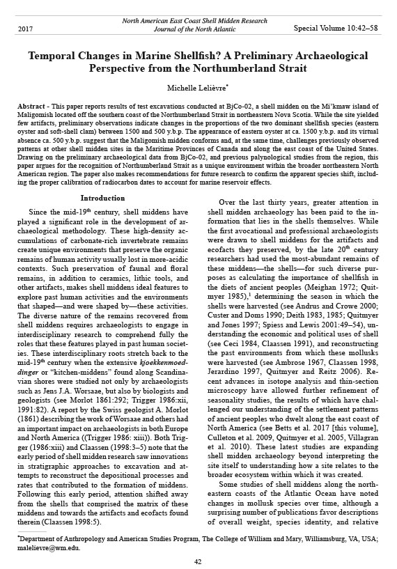
Figure 4 (top) illustrates the comparative weights
of whole shells and chondrophores of the soft-shell
clam and whole eastern oyster shells recovered from
each of the five arbitrary levels excavated in test unit
5C. Figure 4 (bottom) is a multi-plot graph of the
two-sigma age ranges for the radiocarbon dates collected
from BjCo-02. All dates were taken from marine
shells, were calibrated using OxCal’s IntCal13
and Marine1311 calibration curves, and were corrected
for marine reservoir effects by using the ΔR
value for the Pugwash Basin, located about 80 km
from Maligomish (see Table 1). The dates from 5C
cluster around 1500 y.b.p and 500–600 y.b.p.12 These
dates also correspond with the peaks in respective
representation of eastern oyster and soft-shell clam
in unit 5C. The oldest date in 5C was obtained from
shell collected in the lowest level (5), where eastern
oyster was by far the dominant species. Eastern oyster
was still dominant in level 4 (625–500 y.b.p.),
but by a much smaller margin. In the younger levels
(1–3) soft-shell clam became the dominant species.
Thus, the predominance of eastern oyster in BjCo-02
appears to be coincident with a period that preceded
a gap in the use of this midden.
Discussion
The proliferation of shell middens during the
Woodland Period, and shifts in mollusk species over
Journal of the North Atlantic
M. Lelièvre
2017 Special Volume 10
52
ingly dominated by soft-shell clam. Finally, at the
Turner Farm site, Spiess and Lewis (2001:5–7)
documented 3 shell-bearing occupations dating to
between approximately 4555 to 2275 y.b.p. with
soft-shell clam dominating and no eastern oyster
reported.
In comparison to these sites in Maine, the Hudson
estuary, and regions further south, the midden
on Maligomish appears to conform to and, at the
same time, challenge previously observed patterns.
It conforms to the patterns from the Hudson and
the southern sites for the first emergence of eastern
oyster in archaeological contexts around 1500 y.b.p.
However, BjCo-02 challenges the temporal duration
of eastern oyster because the species’ demise appears
to have happened later there than at the southern
sites.
Thus, one of the messages in the Maligomish
midden appears to reference a change between
1500 and 500 y.b.p. Determining the nature of that
change, however, will require further research.
There are limitations on the use of land and freshwater
mollusks as climatic and chronological indicators.
As early as 1969, J.G. Evans noted that local
environmental factors such as changes in moisture
and sedimentation rates affect local populations.
Consequently, when comparing species types and
proportions between archaeological sites, any similarities
or differences may be due to local factors and
not global processes (Evans 1969). Thus, statements
such as Braun’s that the Labrador Current controls
“marine temperatures for all northeastern coastal
waters north of Cape Cod” (Braun 1974:593) should
be taken cautiously by archaeologists who wish to
interpret their materials by way of analogy with
those from other coastal sites. Variations not only in
latitude but also water temperature and salinity, tidal
patterns, and the history of glacial retreat combine to
make unique local environments.
The Northumberland Strait appears to be one
such unique local environment, especially in comparison
with those areas where other shell midden
sites in the Northeast area are found; namely, the
Quoddy region of New Brunswick and Maine, the
Atlantic Coast of Canada, the Bay of Fundy, and
sites further south along the New England coast.
In addition, its unique marine geology, which contributes
to the Strait’s warm temperatures, and a
recent study of the pollen and non-palynological
polymorphs from BjCo-02 seems to confirm that
the vegetative history of this area is very different
than that of sites studied on or near the Atlantic
coast (see Mudie and Lelièvre 2013; see also
Jetté and Mott 1989). Given these differences, the
processes, but instead signaled a change in climate.13
The interest in interpreting changes in shellfish species
over time as indicators of climate change has
persisted amongst archaeologists and other scientists
working in northeastern North America and
around the world (see Carbotte et al. 2004, Claassen
1998:126–134). Indeed, Sandweiss and Kelly (2012)
demonstrate that archaeological studies of species
change and geomorphological processes have not
only contributed vastly to archaeology, but also to
its sister disciplines. They report that observations
of sedimentation at archaeological sites excavated
by David Sanger in the Penobscot River Valley in
Maine have allowed for the creation of a “generalized
sedimentary sequence for the Valley that has
not been found in nonanthropogenic deposit” (Sandweiss
and Kelly 2012:381).
Archaeologists and geologists working in shellbearing
contexts in northeastern North America have
observed a common pattern regarding the temporal
occurrence of eastern oyster and other species.
Carbotte et al. (2004) reported on the presence of
fossil oyster beds in the Hudson River estuary. They
suggest that the fluctuations in oyster representation
may be due to warm–cool cycles during the Holocene.
Within the Hudson, oysters flourished during
the Hypsithermal or mid-Holocene warm period,
disappeared with the onset of a cooler climate at
4000–5000 y.b.p., and returned during the warmer
conditions of the late Holocene (Carbotte et al.
2004:220). Those authors further suggest that the
most recent demise of oysters at 900–500 cal. y.b.p.
may have accompanied the Little Ice Age (Carbotte
et al. 2004:222). They also compare their geological
results to those observed by archaeologists working
in shell-bearing contexts along the Atlantic
coast, including David Sanger’s (see Sanger and
Sanger 1986) work at the Damariscotta River middens
where eastern oysters were reported from only
2400–1000 y.b.p. (Carbotte et al. 2004:221). And
they refer to Claassen’s (1986) work in the southeastern
USA, where eastern oyster only dominates
shell-bearing sites after 2500–1500 y.b.p. In Spiess
et al.’s (2006:145–147) report on their excavations
of the Indiantown Island shell midden on the Gulf
of Maine coast, the authors remark that very few
eastern oysters were recovered from any of the six
cultural units associated with the shell midden that
they excavated, which were dated using diagnostic
ceramics to between 1650 and 400 y.b.p. At Devil’s
Head in Calais, ME, USA, Spiess and Cranmer
(2005:46) similarly dated the site to between 2200
and 600 y.b.p. , with a gap of 700 years between
1600 and 900 y.b.p. This site was again overwhelmJournal
of the North Atlantic
M. Lelièvre
2017 Special Volume 10
53
archaeological sites found along the Northumberland
shores may not be readily compared to sites
along the Atlantic coast whence the bulk of our
coastal data derive.
A further factor complicating the potential of
Maligomish and other middens to reveal the story of
climate change in the Woodland Period is the reliability
and comparability of the recovered data. The
results from the 2008 excavations of BjCo-02 were
limited in scope and included several sampling and
processing errors that may bias the results. One of
these inaccuracies is the use of a non-local ΔR value
to correct for local marine reservoir effects. As Deo
et al. (2004:772) explain: “the ‘reservoir effect’ in
marine samples arises because the oceans are depleted
in 14C compared with the atmosphere and the
deficiency is transmitted to marine organisms.” Due
to the potential depletion of 14C, marine shell samples
tend to date much older than charcoal samples from
the same deposit. Proper calibration of dates obtained
from marine shells can mitigate this problem,
although several researchers have demonstrated the
marine reservoir effects vary widely by location, by
mollusk species, between individuals of the same
species, and over the lifetime of an individual mollusk
specimen (see Culleton et al. 2006, Hadden and
Cherkinsk 2015, Rick and Henkes 2014). Hadden
and Cherkinsky (2015:469) note that “variations in
coastal geomorphology, ocean circulation, and upwelling
create localized, time-dependent deviations
from the global-averaged marine reservoir age.”
While upwelling is unlikely to be a significant factor
in the relatively shallow waters of the Northumberland
Strait and Merigomish Harbour, other factors
may contribute to the marine reservoir effect being
different from the global average.14 For example, the
presence of Carboniferous materials and significant
freshwater inputs could cause 14C activity to differ
significantly between coastal regions (Hadden and
Cherkinsky 2015:469). The bedrock geology of the
mainland south of Merigomish Harbour consists of
Carboniferous deposits. Additionally, three rivers and
several streams empty into the harbor.
Although McNeely et al. (2006) have quantified
the marine reservoir effect in waters off the Canadian
coastlines, the ΔR value closest to Merigomish
Harbour is approximately 80km west in Pugwash
Basin and was derived from a sample of eastern oyster.
This ΔR value may not be an accurate measurement
of the marine reservoir effects in Merigomish
Harbour and may not be useful for calibrating the
radiocarbon dates derived from the soft-shell clam
samples from BjCo-02 for several reasons. First,
Rick and Henkes (2014) demonstrate that there are
variations among the ages of eastern oyster samples
from various locations within the Chesapeake Bay,
suggesting that variation may also be likely for the
eastern oyster found in coastal waters farther north.
Second, Hadden and Cherkinsky's (2015) observations
of variations in ΔR values between species
Figure 5. Comparison of (left) calibrated radiocarbon dates derived from archaeological marine shells collected from levels
2–5 of unit 5C to (right) calibrated radiocarbon dates derived from terrestrial samples from other Northumberland Strait
sites (see also Table 1).
Journal of the North Atlantic
M. Lelièvre
2017 Special Volume 10
54
suggest that the ΔR value derived from the eastern
oyster at Pugwash Basin may be inaccurate for
calibrating soft-shell clam 80 km away in Merigomish
Harbour. Finally, Culleton et al. (2006) recommend
taking samples for AMS dating from multiple
growth increments on marine shell because variations
in marine reservoir effects have been observed
between seasons and over the lifetime of individual
marine shell samples.15 The AMS dates for the Maligomish
midden were derived from small subsamples
of the individual shells submitted for dating
(R. Cruz, NSF-Arizona AMS Laboratory, Tucson,
AZ, USA, pers. comm.). Additional research will be
required in order to mitigate the potential sources
of error in calibrating the radiocarbon ages of the
marine shells collected from the Maligomish midden
and from other sites along the Northumberland Strait
(see Table 1). Ideally, a ΔR value for Merigomish
Harbour would be determined using both eastern
oyster and soft-shell clam samples.
Until such work can be completed, comparison to
terrestrial samples collected in Merigomish Harbour
and the broader Northumberland Strait may be useful
for evaluating the accuracy of the calibrated dates
from Maligomish’s marine shells. Figure 5 compares
the calibrated dates from Maligomish (left) to those
measured on charcoal and moose (Alces alces) collagen
(right) from sites along the Northumberland
Strait (see also Table 1). The dates from Maligomish
cluster around 1500 y.b.p. and 500 y.b.p. A similar
pattern is not observed at the sites for which there
are multiple radiocarbon dates derived from terrestrial
samples—Cox-Swanson (samples S-1602 and
S-1603) and Delorey Island (samples GSC-3218 and
I-11619)—although Delorey Island returned one date
ca. 1500 y.b.p. and the two-sigma range for the oldest
date from Cox-Swanson falls within ca. 1500 y.b.p.
The remaining dates from the Northumberland Strait,
including two from Merigomish Harbour, are either
older (BjCo-15) or younger (S-973) than the range
observed on Maligomish. Thus, with the limited data
available at present, the 1000-year gap observed at
Maligomish does not appear to reflect a gap in cultural
activity elsewhere in the Northumberland Strait.
Possible biases
Several sampling and quantification errors have
introduced biases to this study. Consequently, the
results reported herein should be considered tentative.
These biases include the use of a 0.64-cm
(1/4-inch) mesh screen, which results in the possibility
that invertebrate taxa remains smaller than 0.64
cm (1/4 inch) could have been lost to the back-dirt
pile, thus over-representing the soft-shell clam and
eastern oyster discussed above. The collection of
non-repeating elements, such as the soft-shell clam
chondrophores, may have also overrepresented
the number of soft-shell clam in the midden. The
reported NISP may include, for example, the right
valve and chondrophore from the same individual.16
Conversely, the quantities of eastern oyster may be
underrepresented in the present study. Only whole
eastern oyster shells—not chondrophores—were
systematically collected. Many of the eastern oyster
shells were extremely friable. The remains of these
and other species (e.g., Mytilus edulis [blue mussel])
were so deteriorated in some of the lower levels of
the Maligomish test excavations that they had the
consistency of silt to coarse sand. These deteriorated
shells were not quantified and, therefore, may underrepresent
the presence of eastern oyster.
A further source of bias may be the work of previous
excavators, which include both professional
archaeologists and amateur diggers. Some of the
strata excavated in 2008 may have been disturbed,
while unit 5A showed definite signs of disturbance
at ~15 cm below site datum (b.s.d). The results
reported above focus on unit 5C, which appeared
undisturbed.
Finally, the calibrated AMS radiocarbon dates
measured on the marine shells may be inaccurate
due to the local marine reservoir effects. At present,
the only ΔR value used to correct for marine
reservoir effects that has been calculated for the
Northumberland Strait is from the Pugwash Basin,
located approximately 80 km from Merigomish
Harbour (Fig. 1). The implications of calibrating an
AMS radiocarbon date with a non-local ΔR value are
provided in the discussion above.
Given the biases in the sampling of the Maligomish
midden and in processing its shellfish
remains, the current study does not attempt to infer
a cause for the apparent shift in species proportions
over time.17 The shift may be due to environmental
changes, changes in cultural practices, changes in
site function over time (see Russo 1988:66), and/or
may simply reflect the sampling biases.18 However,
the presence of eastern oyster—a rare occurrence for
shell midden sites this far north—warrants consideration.
The results reported herein may be useful for
future shell midden studies in the Northumberland
Strait and along other coastal waters of the North
Atlantic.
Conclusion
Several questions emerge from this small sample
of the Maligomish midden (BjCo-02). Is the
Journal of the North Atlantic
M. Lelièvre
2017 Special Volume 10
55
Travel Fund from the Division of Social Sciences at the
University of Chicago, the Whatcom Museum, and the
Mi’kmaq-Nova Scotia-Canada Tripartite Forum. I would
also like to acknowledge with deep gratitude the members
of the Pictou Landing First Nation who worked with me
to develop and execute the archaeological research on
Maligomish, including Leonard Cremo, Cheryl Denny,
Dominic Denny, former Chief Ann Francis-Muise, Lorraine
Francis, Michelle Francis-Denny, Ralph Francis,
Sadie Francis, Edie Nicholas, Mary Irene Nicholas, Laura
Prosper, Louise Sapier, Martin (Junior) Sapier, and Florence
Walsh.
Literature Cited
Ambrose, W.R. 1967. Archaeology and shell middens.
Archaeology and Physical Anthropology in Oceania
2(3):169–187.
Andrus, C.F.T., and D.E. Crowe. 2000. Geochemical
analysis of Crassostrea virginica as a method to determine
season of capture. Journal of Archaeological
Science 27:33–42.
Betts, M.W., M. Burchell, and B.R. Schöne. 2017. An
economic history of the Maitime Woodland Period in
Port Joli Harbour, Nova Scotia. Journal of the North
Atlantic Special Volume 10:18–41.
Black, D.W. 1993. What images return: A Study of the
stratigraphy and seasonality of a shell midden in insular
Quoddy region, New Brunswick. Manuscripts in
Archaeology 27. Archaeological Services, Department
of Municipalities, Culture, and Housing, Fredricton,
NB, Canada.
Borden, C.E., and D. Wilson. 1952. A Uniform Site Designation
Scheme for Canada. Anthropology in British
Columbia 3:44–48.
Braun, D.P. 1974. Explanatory models for the evolution of
coastal adaptation in prehistoric eastern New England.
American Antiquity 39(4):582–596.
Brennan, L.A. 1963. A 6000-year-old midden of Virginia
oyster shell at Croton Point, lower mid-Hudson. Pp.
55-59, In The Coastal Archaeology Reader: Selections
from the New York State Archaeological Association
Bulletin. 1954–1977. Available online at http://nysarchaeology.
org/download/nysaa/bulletin/number_29.
pdf. Accessed 6 December 2016.
Campbell, S. 1981. The Duwamish No. 1 site, A lower
Puget Sound shell midden. Office of Public Archaeology,
Research Report 1. University of Washington,
Seattle, WA.
Canadian Museum of History - Library and Archives
(CMH-L&A). 1912. Wintemberg, W.J. Field Notes.
N.B., N.S. 1912. Manuscript Nos. 196. Vol. 5. p. 28.
Ottawa, ON, Canada.
Carbotte, S.M., R.E. Bell, W.B.F. Ryan, C. McHugh, A.
Slage, F. Nitsche, and J. Rubenstone. 2004. Environmental
change and oyster colonization within the
Hudson River estuary linked to Holocene climate.
Geo-Marine Letters 24:212–224.
Ceci, L. 1984. Shell midden deposits as coastal resources.
World Archaeology 16(1):62–74.
1000-year gap simply due to a sampling error or is it
reflective of an environmental shift and/or changes
in cultural practices? What accounts for the apparent
persistence of eastern oyster at Maligomish when it
is almost completely absent from some coastal sites
in Maine and had been phased out from sites further
south well before the Late Woodland Period? Claassen
(1986) considers several hypotheses to explain
the temporal shifts in species, including the die-off
of species, overexploitation, innovations in harvesting
technology, and environmental change. Of these,
she is most persuaded by the environmental hypothesis,
citing rising sea levels as the primary cause.
Carbotte et al. (2004:220) report that the primary
environmental factors that influence oyster growth
include salinity, temperature, substrate type, and
sedimentation rate. It seems that the way forward for
contextualizing the Northumberland Strait among
other Atlantic shell midden sites is to first gather
more information regarding these factors.
All of this work can contribute to developing models
for human use and impact on local environments
rather than treating the entire coast of the Northeast as
one uniform region. Most importantly, the answer to
the apparent puzzle presented at Maligomish will be
more excavation, better sampling of the midden context
(see Claassen 1998:99–104), systematic analysis
of the marine shell remains, and studies comparing
the radiocarbon ages of archaeological marine shells
to marine shells of known age to determine localized
marine reservoir effects (see Hadden and Cherinsky
2015, Rick and Henkes 2014, Rick et al. 2012)—objectives
made all the more urgent by the effects of contemporary
climate change that threaten the survival of
these archaeological contexts.
Acknowledgments
Thank you to the anonymous reviewers for their careful
readings of the first draft of this paper and to Philippa
Ascough and Keith Goldfarb for their editorial guidance.
Thank you to Matthew Betts and Martin (Gabe) Hyrnick
for organizing the session on east coast shell middens
for the 2014 meeting of the Eastern States Archaeological
Federation and for their comments on the revised
manuscript. Special thanks also to several participants in
that session who helped me at various stages during the
fieldwork reported here. These participants include David
Black, David Sanger, and Arthur Spiess, who all offered
advice on how to excavate shell middens. Matthew Betts
was very helpful in granting me access to collections at
the Canadian Museum of History. Other archaeologists
and museum staff in Nova Scotia offered much support:
Scott Buchanan, Tim Bernard, David Christianson,
Stephen Davis, Roger Lewis, Heather MacLeod-Leslie,
Debra McNabb, Robert Ogilvie, Stephen Powell, and
Leah Rosenmeier. The research was funded by the Janco
Journal of the North Atlantic
M. Lelièvre
2017 Special Volume 10
56
Fladmark, K. 1978. A Guide to Basic Archaeological Field
Procedures. Department of Archaeology, Simon Fraser
University. Publication No. 4. Simon Fraser University,
Burnaby, BC, Canada.
Glassow, M.A. 2000. Weighing vs. counting shellfish
remains: A comment on Mason, Peterson, and Tiffany.
American Antiquity 65(2):407–414.
Hadden, C., and A. Cherkinsky. 2015. 14C variations in
pre-bomb nearshore habitats of the Florida Panhandle,
USA. Radiocarbon 57:469–479.
Jerardino, A. 1997. Changes in Shellfish Species Composition
and Mean Shell Size from a Late-Holocene
Record of the West Coast of Southern Africa. Journal
of Archaeological Science 24:1031–1044.
Jetté, H., and R.J. Mott. 1989. Palynostratigraphie du
Tardiglaciaire et de l’Holocène de la région du Lac
Chance Harbour, Nouvelle-Écosse. Géographie physique
et Quaternaire. 43:27–38.
Johnson, M. 2008. Maillard, Pierre. Dictionary of Canadian
Biography Online. Available online at http://
www.biographi.ca/EN/ShowBio.asp?BioId=35630.
Accessed 2 March 2008.
Keenlyside, D.L. 1980. 1978. Pp. 14–16, In R.J.M. Marois
(Ed.). Archaeology Survey of Canada Annual Reviews
1977–1979. National Museums of Canada, Ottawa,
ON, Canada.
Kepple, J.D. (Compiler). 2000. Geological map of the
Province of Nova Scotia, Nova Scotia Department of
Natural Resources, Minerals and Energy Branch, Halifax,
NS, Canada. Map ME 2000-1, scale 1:500,000.
Kirakosian, K.V. 2014. Curious monuments of the simplest
kind: Shell midden archaeology in Massachusetts.
Doctoral Dissertation. University of Massachusetts
– Amherst, MA, USA. 504 pp.
Kranck, K. 1971. Surficial Geology of Northumberland
Strait. Marine Science Paper 5. Geological Survey of
Canada Paper 71-53. Marine Sciences Branch: Department
of the Environment, Ottawa, ON, Canada.
Lelièvre, M.A. 2008. Heritage Research Permit
A2008NS02: Report on surface investigations and
sub-surface testing of Maligomish (Indian Island),
Pictou County, Nova Scotia. Spring 2008. Unpublished
manuscript on file with Museum Operations,
Nova Scotia Museum, Halifax, NS, Canada.
Lelièvre, M.A. 2012. Ajiwisin (you move from one place
to another): Mobility, emplacement, and politics in
(Post-) Colonial Nova Scotia. Ph.D. Dissertation. University
of Chicago, Chicago, IL, USA.
Mason, R.D., M.L. Peterson, and J.A. Tiffany. 1998.
Weighing vs. counting: Measurement reliability and
the California School of midden analysis. American
Antiquity 63(2):303–324.
McNeely, R., A.S. Dyke, and J.R. Southon. 2006. Canadian
marine reservoir ages: Preliminary data assessment.
Geological Survey Canada Open File 5049,
Ottawa, ON, Canada.
Meehan, B. 1982. Shell Bed to Shell Midden. Australian
National University, Canberra, Australia.
Meighan, C.W. 1972. Midden remains and prehistoric
food resources. Archaeological Survey Annual Report
14:3–11.
Claassen, C. 1986. Temporal patterns in marine shellfishspecies
use along the Atlantic coast in the southeastern
United States. Southeastern Archaeology 5:120–137.
Claassen, C. 1991. Normative thinking and shell-bearing
sites. Pp. 249–298. In M.B. Schiffer (Ed.). Advances
in Archaeological Method and Theory. Vol. 3. The
University of Arizona Press, Tucson, AZ, USA.
Claassen, C. 1998. Shells. Cambridge University Press,
Cambridge, UK.
Claassen, C. 2000. Quantifying shell: Comments on
Mason, Peterson, and Tiffany. American Antiquity
65(2):415–418.
Confederacy of Mainland Mi’kmaq. 2007. Kekina’muek:
Learning about the Mi’kmaq of Nova Scotia. Eastern
Woodland Publishing, Truro, NS, Canada.
Culleton, B.J., D.J. Kennett, B.L. Ingram, J.M. Erlandson,
and J.R. Southon. 2006. Intrashell radiocarbon variability
in Marine mollusks. Radiocarbon. 48:387–400.
Culleton, B.J., D.J. Kennett, T.L Jones. 2009. Oxygen isotope
seasonality in a temperate estuarine shell midden:
A case study from CA-ALA-17 on the San Francisco
Bay, California. Journal of Archaeological Science
36:1354–1363.
Custer, J.F., and K.R. Doms. 1990. Analysis of microgrowth
patterns of the American Oyster (Crassostrea
virginica) in the Middle Atlantic Region of Eastern
North America: Archaeological application. Journal of
Archaeological Science 17:151–160.
Davis, D.S., and S. Browne. 1996. The Natural History of
Nova Scotia. Volumes I and II. Nimbus Publishing and
the Nova Scotia Museum, Halifax, NS, Canada.
Deith, M.R. 1983. Seasonality of shell collecting determined
by oxygen isotope analysis of marine shells
from Asturian sites in Cantabria. Pp. 67–76, In C.
Grigson and J. Clutton-Brock (Eds.). Animals and
Archaeology. Vol. 2. Shell Middens, Fishes, and Birds,
B.A.R. International Series 183, Oxford, UK.
Deith, M.R. 1985. Seasonality from shells: An evaluation
of two techniques for seasonal dating of marine molluscs.
Pp. 119–130, In N.R.J. Fieller, D.D. Gilbertson,
and N.G.A. Ralph (Eds.). Palaeobiological Investigations
Research Design, Methods, and Data Analysis.
B.A.R. International Series 266, Oxford, UK.
Deo, J.N., J.O. Stone, and J.K. Stein. 2004. Building confidence
in shell: Variations in the marine radiocarbon
reservoir correction for the northwest coast over the
past 3000 years. American Antiquity 69(4):771–786.
Erskine, J. 1961. Micmac Notes, 1960. Nova Scotia Museum,
Occasional Paper 11, Archaeological series no.
1. Nova Scotia Museum, Halifax, NS, Canada.
Erskine, J. 1969. What can be learned from shell-heaps?
Archaeological Society of Nova Scotia, Halifax, NS,
Canada. Bulletin. No. 3.
Erskine, J. 1986. Unpublished papers on the archaeology
of the Maritime provinces. Compiled by M. Deal,
Department of Anthropology, St. Mary’s University.
Halifax, NS, Canada.
Evans, J.G. 1969. Land and freshwater mollusca in archaeology:
Chronological aspects. World Archaeology
1(2):170–183.
Journal of the North Atlantic
M. Lelièvre
2017 Special Volume 10
57
Russo, M. 1988. A Comment on Temporal Patterns in
Marine Shellfish Use in Florida and Georgia. Southeastern
Archaeology 7:61–68.
Sandweiss, D.H., and A.R. Kelly. 2012 Archaeological
contributions to climate change research: The archaeological
record as a paleoclimatic and paleoenvironmental
archive. Annual Review of Anthropology
41:371–391.
Sanger, D., and M.J. Sanger. 1986. Boom and bust on the
river: The story of the Damariscotta oyster shell heaps.
Archaeology of Eastern North America 14:65–78.
Smith, H. and W.J. Wintemberg. 1929. Some Shell-heaps
in Nova Scotia. National Museum of Canada Bulletin,
47. National Museums of Canada, Ottawa, ON,
Canada. 193 pp.
Snow, D.R. 1972. Rising sea level and prehistoric cultural
ecology in northern New England. American Antiquity
37(2):211–221.
Snow, H.E. 1994. Archaeological investigations at Kerr
Point (BjCo-15) Merigomish Harbour, Nova Scotia.
BA Honours Thesis. Department of Sociology and
Anthropology, St. Francis Xavier University, Antingonish,
NS, Canada
Spiess, A.E., and L. Cranmer. 2005. Devils Head, Calais,
and Site 97.10: Archaeological Survey for the Land
Maine’s Future Board. Maine Historic Preservation
Commission, Augusta, ME, USA.
Spiess, A.E., and R.A. Lewis. 2001. The Turner Farm
Fauna: 5000 Years of Hunting and Fishing in Penobscot
Bay, Maine. Occasional Publications in Maine
Archaeology. Number Eleven. The Maine State Museum,
The Maine Historic Preservation Commission
and the Maine Archaeological Society, Augusta, ME,
USA. 177 pp.
Spiess, A.E., K. Sobolik, D. Crader, J. Mosher and D.
Wilson. 2006. Cod, clams, and deer: The food remains
from Indiantown Island. Archaeology of Eastern North
America 34:141–187.
Stein, J.K. (Ed.) 1992. Deciphering a Shell Midden. Academic
Press, Inc., San Diego, CA, USA. 375 pp.
Trigger, B.G. (Ed.) 1986. Native Shell Mounds of North
America: Early Studies. Garland Publishing Inc., New
York, NY, USA.
Trigger, B.G. 1991. A History of Archaeological Thought.
Cambridge University Press, Cambridge, UK. 500 pp.
Villagran, X.S., A.L. Balbo, M. Madella, A.Vila, and J. Estevez.
2011. Experimental micromorphology in Tierra
del Fuego (Argentina): Building a reference collection
for the study of shell middens in cold climates. Journal
of Archaeological Science 38(3):588–604.
Waters, J.H. 1965. Animal remains from some New England
sites. Bulletin of the Archaeological Society of
Connecticut 33:5–11.
Webb, K.T. 1990. Soils of Pictou County, Nova Scotia.
Report No. 18 (with accompanying map sheets: Soils
of Pictou County [East and West]). Nova Scotia Soil
Survey. Research Branch, Agriculture Canada, Ottawa,
ON, Canada.
Morlot, A. 1861. General views on archaeology. Pp.
285–343, In Annual Report of the Smithsonian Institution
for 1860. Smithsonian Institution, Washington,
DC, USA.
Mudie, P.J., and M.A. Lelièvre. 2013. Palynological
study of a Mi’kmaw shell midden, Northeast Nova
Scotia, Canada. Journal of Archaeological Science
40:2161–2175.
Patterson, Rev. G. 1877. A History of the County of Pictou,
Nova Scotia. Dawson Brothers, Montreal, QC,
Canada.
Patterson, Rev. G. 1889. The Stone Age in Nova Scotia,
as illustrated by a collection of relics presented to
Dalhousie College. Transactions of the Nova Scotian
Institute of Natural Science 7(3):231–252.
Peacock, E. 2000. Assessing bias in archaeological
shell assemblages. Journal of Field Archaeology
27(2):183–196.
Pretola, J. 1973. The Marshall site: An early contact shell
midden from Nantucket Island. Masters Thesis. University
of Massachusetts – Amherst, MA, USA.
Province of Nova Scotia (H. Piers). 1935. Report on the
Provincial Museum and Science Library for the fiscal
year 1933–1934. Provincial Secretary, King’s Printer,
Halifax, NS, Canada.
Quitmyer, I.R. 1985. Aboriginal subsistence activities in
the Kings Bay locality. Pp. 73–91, In W.H. Adams
(Ed.). Aboriginal Subsistence and Settlement Archaeology
of the Kings Bay Locality. Volume 2: Zooarchaeology.
Department of Anthropology, University
of Florida, Gainsville, FL, USA.
Quitmyer, I.R., and D.S. Jones. 1997. The Sclerochronology
of hard clams, Mercenaria spp., from the southeastern
USA: A method of elucidating the zooarchaeological
records of seasonal resource procurement and
seasonality in prehistoric shell middens. Journal of
Archaeological Science 24:825–840.
Quitmyer, I.R., and E.J. Reitz. 2006. Marine trophic levels
targeted between AD 300 and 1500 on the Georgia
coast, USA. Journal of Archaeological Science
33:806–822.
Quitmyer, I.R., D.S. Jones, and C.F.T. Andrus. 2005. Seasonal
collection of Coquina Clams (Donax variavilis)
During the Archaic and St. Johns Periods in coastal
northeast Flordia. Pp. 18–28, In D. Bar-Yosef (Ed.). Archaeomalacology:
Molluscs in Former Environments
of Human Behavior. Oxbow Press, London, UK.
Rand, S. 1902. A Dictionary of the Micmac Language.
The Patriot Publishing Company, Charlottetown, PEI,
Canada.
Reimer, Paula J. et al. 2013. IntCal13 and Marine13 radiocarbon
age calibration curves 0–50,000 years cal BP.
Radiocarbon 55:1869–1887.
Rick, T.C., and G.A. Henkes. 2014. Radiocarbon variability
in Crassostrea virginica shells from the Chesapeake
Bay, USA. Radiocarbon 56:305–311.
Rick, T.C., G.A. Henkes, D.L. Lowrey, S.M. Colman,
B.J. Culleton. 2012. Marine radiocarbon reservoir
corrections (ΔR) for Chesapeake Bay and the Middle
Atlantic Coast of North America. Quaternary Research
77:205–210.
Journal of the North Atlantic
M. Lelièvre
2017 Special Volume 10
58
Endnotes
1 See also Meehan’s (1982) ethnoarchaeological study of
shellfish gathering among the Anbarra of Arnhem Land in
northern Australia
2Mi’kmaw is used as a singular noun, as an adjective to
modify both singular and plural nouns and when discussing
the Mi’kmaw language. Mi’kmaq is a plural noun (see
Confederacy of Mainland Mi'kmaq 2007:24).
3In his 1929 report for the National Museum of Man,
Smith did not describe having excavated this midden
(Shell-heap “D” in the Smith report; see Smith and
Wintemberg 1929:6, 7–8). Instead he stated that he had
purchased five artifacts likely obtained from the midden
from a Mi’kmaw man named Joseph Philip who lived on
Maligomish. In 1960, the avocational archaeologist John
Erskine reported that he had encountered one of Smith’s
companions who had told him that Smith had actually excavated
on Maligomish for half a day before the Mi’kmaw
caretaker of the island had warned him of f for trespassing
on the reserve (Erskine 1961:21). This second-hand report
suggests that Smith conducted excavations on Maligomish
but did not report them in the official publication. All of
the artifacts that Smith and Wintermberg collected from
Merigomish Harbour and the surrounding area are now
housed at the Canadian Museum of History in Gatineau,
QC, Canada.
4During the fall 2008 excavations, we adopted the Parks
Canada provenience system (see http://www.pc.gc.ca/eng/
docs/pc/guide/fp-es/4.aspx. Accessed 16 October 2015).
5Despite the best efforts to avoid the ghost of Erskine, he
resurfaced in one of the 1 m x 1 m test units: Operation 5A.
We abandoned this unit after excavating 15 cm because we
were able to observe the outlines of a previous excavation
unit, most likely one of Erskine’s.
6These other species included: Mytilus edulis, Spisula
solidissima, Mercenaria mercenaria, Crepidula sp., and
Littorina sp.
7See Mason et al. 1998, Glassow 2000, and Claassen 2000
for a debate on weighing vs. counting shellfish remains.
8Any future research on the materials collected from
the Maligomish midden (BjCo-02) under Nova Scotia
Heritage Research Permits A2007NS74, A2008NS02, and
A2008NS73 will have to be conducted with permission
from the Chief and Council of the Pictou Landing First
Nation (PLFN). These collections were temporarily transferred
in August 2010 to the Nova Scotia Museum, where
they are being held in trust for the PLFN until a suitable
storage facility operated by a Mi’kmaw organization becomes
available.
9A similar variety of mollusk species was recovered from
the Rustico Island shell midden (CcCt-01) off Prince
Edward Island. See the unpublished fieldnotes of Birgitta
Wallace and her crew from Rustico Island (7F) which are
on file with Parks Canada in Dartmouth, NS (Janet Stoddard,
Collections Specialist, Parks Canada, Dartmouth,
NS, Canada, pers. comm.).
10See Black (1993:60–62) for a discussion of marine shell
stratigraphy in shell midden sites from the Quoddy region
of New Brunswick.
11Reimer et al. (2013:1871) note that “because Marine13
is based on tropical and subtropical records, its application
to 14C ages from samples at higher latitudes must take into
consideration additional and possibly large changes in the
age of the local surface ocean.” The AMS dates reported
here were calibrated using both Marine09 and Marine13.
The two-sigma ranges for the samples from 5C2 and 5C3
were exactly the same using each calibration curve. The
two-sigma ranges for the samples from 5C4 and 5C5 varied
slightly between the calibration using the Marine09
and Marine13 curves. For 5C4, Marine09 = 624–499
y.b.p.; Marine13 = 625–500 y.b.p. A greater variation was
observed for 5C5: Marine09 = 1613–1342; Marine 13 =
1608–1344).
12The gap of approximately 1000 years was also observed
15 m to the east of unit 5C in Test Pit 2, which was excavated
during the spring 2008 field season (see Table 1).
13My thanks to Katharine Vickers Kirakosian for directing
my attention to the debates between Waters, William
Ritchie, and John Pretrola, as discussed in her dissertation
(Kirakosian 2014).
14Culleton et al. (2006:389) note that “upwelling of deep
ocean water is associated with older apparent 14C age and
larger ΔR values because of slow mixing that leaves the
global marine 14C reservoir depleted relative to the atmosphere.”
15Culleton et al. (2006:398) note that annual to seasonal
changes in ΔR on the scale of 100–200 14C yr represent
significant sources of random dating error for archaeologists
working in aquatic settings.
16One of the anonymous reviewers of the first draft of
this article recommended re-analyzing the collection to
estimate the minimum number of individuals by sorting
the valves and chondrophores side by side, with the more
abundant side being interpreted as the MNI. Accessing the
collection for this re-analysis will require the permission
of the Pictou Landing First Nation. See note 8.
17Claassen (1998:101–104) urges caution when trying
to infer environmental or human behavior from poorly
sampled remains. She cites Campbell’s (1981:220–223)
sampling strategy at Duwamish No. 1 site in Seattle, WA:
“No attempt to determine if the differences in shell species
composition between proveniences were due to cultural
or environmental changes because Campbell could not
justify the assumption that the shell data from the four test
units were representative of a site-wide temporal trend”
(Claassen 1998:103).
18On the ability of archaeologists to infer the aquatic habitats
of the mollusk species represented in middens, Stein
(1992:9) has argued that such inferences would require
“accepting the assumption that the shellfish species found
in shell middens are adequate reflections of environmental
conditions in adjacent habitats. One must assume that
people were selecting shellfish randomly, depositing a
random sample of the species inhabiting the bay.”