J. Baker and S. Brookes
2013 Journal of the North Atlantic Special Volume 5
76
Introduction
It is widely accepted that by the 11th century—
and perhaps by then for at least a hundred years—the
vills of England were grouped into administrative
districts known as hundreds. There are good grounds
for this perception, for it is probably accurate that
most of England by that time was governed through
a layered structure of local and regional assemblies
anchored within territorial units, and for centuries
open-air gatherings had been the central forums of
legal dialogue and social negotiation (cf. the laws: I
Æthelberht; VI Æthelstan 8.1–8.3; The Hundred Ordinance
[ca. AD 939–61]). In Domesday Book, vills
were listed together under the head of “hundred” or
“wapentake”—units which were both territorial arrangements
and legal entities. These units were generally
named directly from the places at which their
inhabitants assembled; commonly open-air sites, but
sometimes head manors or towns (Anderson 1934,
1939a, 1939b). These places served as courts for the
communities of the hundred, among the functions of
which were the public settlement of disputes through
oath-taking and compensation payment, policing
and military muster, alongside—presumably—the
collection of taxes.
While this model holds true in the most general
of senses, it is one that also obscures a very much
more complex reality of administrative and territorial
organization; a system that exhibits considerable
variations in scale, structure, and terminology from
region to region. For example, while hundreds and
wapentakes are often treated as equivalent units,
in Durham, Northumberland, Westmoreland, and
Cumberland (where Domesday coverage is anyway
thinner) neither hundreds nor wapentakes are
normal, and the landscape is instead divided territorially
into large districts called wards. Even the
word “equivalent” must be used with caution, for it
may turn out that the equivalence suggested by the
Domesday treatment of wapentakes and hundreds
extends no further than the fact that they were territorial
groupings of vills that shared some functional
similarities in the 11th century (Hart 1992:281–283).
Their historical origins and precise administrative
status may sometimes have differed. In Lincolnshire,
Leicestershire, and perhaps Derbyshire and
Nottinghamshire, each wapentake was itself divided
into twelve-carucate hundreds by the early 12th century,
an administrative structure that Horace Round
(1895:196–204) traced back to 1086 or earlier (see
also Hadley 2000:101–104, Hart 1992:337–410,
Stenton 1910:89). Superficially, this arrangement
mirrors (in structure though not in status or perhaps
function) the lathes of Kent and rapes of Sussex,
which were also further subdivided into districts
called hundreds, but these latter units were in fact
very different from the Lincolnshire hundreds.
Similar complexity is encountered if we consider
meeting-places themselves. Detailed analysis of individual
sites strongly suggests that while hundred
and shire courts (not to mention ecclesiastical councils,
witans, or military musters) could, and sometimes
did, reuse the same locations in landscape, in
many cases different functions and activities took
place across a diverse range of places.
Reconstruction of this complex administrative
landscape concentrates on two principal lines of
analysis. Hundred court sites can often be identified
Governance at the Anglo-Scandinavian Interface:
Hundredal Organization in the Southern Danelaw
John Baker1,* and Stuart Brookes2
Abstract - It is a commonplace notion of Anglo-Saxon studies that by the 11th century, and perhaps very much earlier,
English shires were subdivided into administrative territories known as “hundreds” or “wapentakes”. These units consisted
of groups of vills brought together for fiscal, judicial, and other purposes, and were commonly named after their meetingplaces—“
moots”. Both these meeting-places and the administrative territories to which they belonged are the subject of
a three-year interdisciplinary research project funded by the Leverhulme Trust—“Landscapes of Governance: Assembly
Sites in England, 5th–11th Centuries”. Landscape analysis carried out by this project suggests that the hundredal pattern of
eastern England as it existed in 1086 preserves a complex palimpsest of older and newer elements, reflecting its convoluted
evolution. This paper describes evidence for the hundredal patterns of the southern Danelaw in order to consider the West
Saxon, Mercian, and Scandinavian influences on the administrativ e landscape of this region.
Debating the Thing in the North I: The Assembly Project
Journal of the North Atlantic
1Institute for Name-Studies, University of Nottingham, University Park, Nottingham, NG7 2RD, UK. 2UCL Institute of
Archaeology, 31–4 Gordon Square, London WC1H 0PY, UK. *Corresponding author - John.baker@nottingham.ac.uk.
2013 Special Volume 5:76–95
J. Baker and S. Brookes
2013 Journal of the North Atlantic Special Volume 5
77
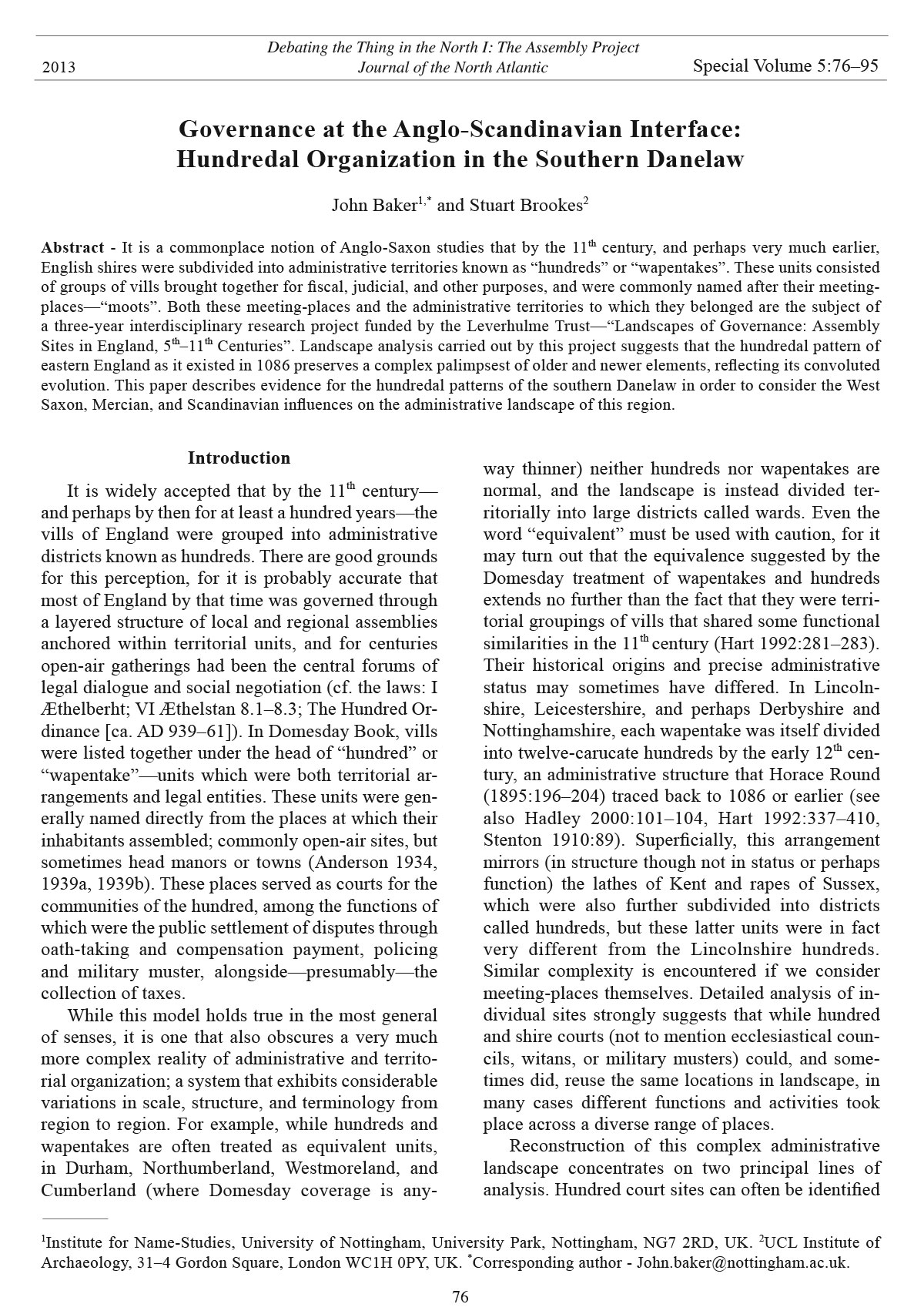
by triangulating onomastic, archaeological, and
landscape evidence, while the territories which
they served can be approximated by plotting the
named 11th-century vills constituting a hundred,
supplemented by the boundaries of estates, parishes,
and hundreds mapped at later dates (Thorn
Figure 1. Map of the administrative districts of England as reconstructed from Domesday Book and later medieval sources.
Also shown is the extent of the “Danelaw”, as defined by Hadley (2000:3).
J. Baker and S. Brookes
2013 Journal of the North Atlantic Special Volume 5
78
1989:27–28). Using these sources as a guide gives
an impression of the variety in size and shape of
these territories, and also highlights a number of
regional patterns perhaps reflecting different phases
of administrative organization (Fig. 1). The particularly
heterogeneous pattern of administrative
territories in the western English shires of Gloucestershire,
Warwickshire, and Worcestershire, for
example, suggests a complex evolution of territorial
organization, supported also by detailed historical
research (e.g., Whybra 1990). By contrast, the more
regular pattern of hundreds in, for example, Surrey,
might suggest that these are the product of a phase of
administrative reorganization that took place shortly
before the time of Domesday Book.
Taken as a whole, the hundredal system of local
governance as it is revealed to us in the 11th century
is territorially and administratively both intricate
and divergent. Nevertheless, despite such regional
variability, certain shires display a remarkably
similar pattern of organization. This paper outlines
the evidence for reconstructing these territories in
part of the Danelaw, taking the region covered by
the Five Boroughs, East Anglia, and the southeast
midlands as its main focus. It highlights the considerable
variety in administrative geography and
arrangements across these shires, providing possible
explanations of the genesis of their legal and
governmental districts. In so doing, it throws new
light on the origins and evolution of the system of
hundredal governance as it appears at the end of the
Anglo-Saxon period.
The Hundreds and Wapentakes of the Danelaw
The “Danelaw” was an area comprising territories
in northern and eastern England, distinguished
in legal terms from areas where Mercian or West
Saxon law prevailed. The term was first used in a
law-code of 1008, and only became common in the
12th century (Hadley 2000:2), but the legal territory
it describes likely originated in the settlements of
the Great Army during the later 9th century, perhaps
first given formal definition in the treaty between
Alfred and Guthrum of ca. 878–890. Although this
region was subject to a West Saxon “conquest”
during the early 10th century, the degrees to which
it came fully under the ambit of English rule may
have varied across the Danelaw, with northern
areas arguably retaining more characteristically
Scandinavian features than areas on the interface
with Wessex and Mercia (cf. Hadley 2000, Stenton
1910).1 During the late 9th and 10th centuries, parts
of the southern Danelaw oscillated between English
(Mercian, East Anglian, West Saxon, or Anglo-Saxon)
and Scandinavian (Norwegian Viking or Danish
Viking) control. It is a region, therefore, that is
likely to have been susceptible to rapid and drastic
change in its administrative organization, as different
traditions were brought into contact, and as new
regimes came to terms with existing structures of
governance.
An impression of the degree of administrative
dislocation can be gained by comparing the distribution
of place-names denoting places of assembly
with known hundred meeting-places (Fig. 2). One
possibility is that the former sometimes make reference
to the latter, but are otherwise remnants of other
systems of governance separate from the hundredal
arrangements of the 11th century. In that case, the
less the two types of site coincide, the more likely it
is that local administration has undergone substantial
reorganization, encompassing the reallocation
of territories of governance and the adoption of
new sites of assembly. On this basis, it can be asserted
that the areas of England south of the Humber
most affected by administrative changes were in the
northern and western midlands, northern East Anglia,
and along the Thames. Of course, a proliferation
of place-names denoting assembly might have
other causes, but the map is at least likely to indicate
variation in administrative landscapes.
That significant differences exist between the
administrative organization of northern and southern
England is perhaps unsurprising. The probability of
a partly Scandinavian background to the administrative
organization of Lindsey and Yorkshire in the
northern Danelaw has long been recognized (e.g.,
Roffe 1981, 1993:38–39; Sawyer 1998:137–139;
Smith 1928:xxii; Stenton 1927). An especially
marked feature is their division into three parts,
known as Ridings. These divisions existed already in
the 11th century and have a Scandinavian terminology.
The term Riding derives from OScand þriðjungr
“third part”, which gave rise to late OE þriðing, and
the run of early spellings for the East Riding of Yorkshire
seem clearly to reflect OScand austr rather
than OE east “east”.2 It is possible that the divisions
themselves predated the application of Scandinavian
administrative terminology, but since this seems to
have stuck to the exclusion of earlier, Old English
nomenclature, it is probably reasonable to assume
that the threefold division of these two shires was
a Scandinavian administrative innovation. Subdivisions
of the Ridings are known as wapentakes, again
a description of Scandinavian origin, and in many
cases the wapentakes have Scandinavian names.
As Smith (1962:64–65) pointed out, moreover, the
J. Baker and S. Brookes
2013 Journal of the North Atlantic Special Volume 5
79
smallest units in the administrative chain, the townships,
were often known by the OScand term *býjarlǫg
“law of the village”, which survives in placenames
such as Brampton Bierlow (Smith 1961:106,
222). Parsons and Styles (2000:112) describe this as
“an area in which minor disputes could be settled
by locally-agreed laws”, and Ekwall (1922:201)
wondered if similarly named divisions in Dalton in
Furness, Lancashire, might have been an old Scandinavian
institution. Care is needed, however, since
Figure 2. Map showing the distances between place-names denoting assembly and known hundred meeting-places.
J. Baker and S. Brookes
2013 Journal of the North Atlantic Special Volume 5
80
*býjar-lǫg place-names are not recorded until the
late medieval period (e.g., Bramtun birlagh in 1307;
Smith 1961:106). How long before this the administrative
designation was first used is impossible to
say, although the compound must have come into
being in an environment where Old Scandinavian
inflexion was active. The institution it describes
could be a development comparable to arrangements
in other parts of England (Jewell 1972:60–61), here
simply described using vocabulary of Scandinavian
origin that by this time had become a part of wider
English lexis (cf. Kurath et al. 1956–2001 [sub bīrlaue],
Oxford English Dictionary [sub byrlaw]).
Nevertheless, in these parts of the Danelaw, it seems
that a Scandinavian terminology and in part a Scandinavian
system was established whereby a shire
unit based on a central settlement—York or Lincoln—
was divided into three parts, each of which
was sub-divided into wapentakes, below which, at
some stage and in some instances, a further stratum
of local governance at township level came to be referred
to using Scandinavian terminology (Cameron
1991:7; Cameron 2001:1, 6; Smith 1928:xiv–xv,
xxii, 1; Smith 1937; Smith 1962:64–65, 117–118).
Scandinavian features may also be evident in
the organization of East Anglian administrative
districts, but they seem to differ substantially from
those of Lincolnshire and Yorkshire. Several features
of the East Anglian administrative structure
mark it as distinctive, and the notable differences
are perhaps evident throughout the hierarchy of
territorial divisions. Warner (1988) has discerned
possible traces of a pre-Scandinavian administrative
system, but Scandinavian administrators have
also seemingly left a mark. In several instances in
Norfolk and Suffolk, further subdivisions existed
below that of the hundred. These are referred to in
Domesday Book as ferdings or “quarters”, probably
after the ON fjórðungr, and they divided hundreds
into four equal parts (Anderson 1934:xviii; Stenton
1922:226, n.3; Warner 1988:22). The evidence may
be circumstantial, but the parallels between East Anglia
and legal/administrative arrangements in Scandinavia
and perhaps in Shetland are striking. Warner
(1988:22) notes Ferdings also in Huntingdonshire
and Cambridgeshire.3
Much of this is relatively uncontroversial. Rather
more tentatively, it is perhaps also worth noting that
the nomenclature for the two major subdivisions of
East Anglia, Norfolk (“the north people”) and Suffolk
(“the south people”),4 is almost unique among
shire-names in England.5 The use of folc “people,
nation” (Cameron et al. 2007) as a district-name
generic need be no more than a reflection of longstanding
differences in the traditions of naming in
that part of the country, but it is an interesting coincidence,
if nothing more, that the nomenclature for
the equivalent districts on the other side of the North
Sea, on the Norwegian coast, is dominated by the
related OScand fylki “army, district”.6 The exact OE
equivalent, (ge)fylce “troop, band, army”,7 is poorly
attested after the Old English period, its only ME
record being a 13th-century Worcester gloss that renders
it ifolke (Kurath et al. 1956–2001). The expected
ME outcome would have had a palatalized and assibilated
final consonant (pronounced in a similar way
to the ch of modern English mulch), and this would
usually have resulted in ME spellings representative
of that. For instance, the spelling or (at least
from the 12th century) might have been used
rather than , which generally indicates a pronunciation
similar to the k in modern ilk or indeed ME
folk (Campbell 1959:230 §578, 196–197 §486; Hogg
1992:260 § 7.24; Jordan 1974:166 §179.8c; Wright
and Wright 1928:9 §14). It is possible, as the Middle
English Dictionary entry implies, that the ME form
has been influenced by association with OE folc
(ME folk), which suggests that the two words were
perceived to be semantically related (Kurath et al.
1956–2001). In that case, it is not inconceivable that
OScand fylki, if used by Scandinavian administrators
in East Anglia, would have been reanalyzed by
English speakers as folc.8 Given the phonology of the
various terms, folc may have seemed, superficially
at least, as closely related to fylki as (ge)fylce was.
It is important to emphasize, nonetheless, that there
are other possible (and perhaps easier) explanations
for the occurrence of the shire-names Norfolk and
Suffolk, and that the suggestion outlined here is put
forward only with caution.
In Norway, each fylki is likely to have had its
own thing or “assembly” (e.g., Larson 1935:15,
Skre 2007:386–89), and it may also be noteworthy
that two instances of þing-haugr, a recurrent and
distinctively Scandinavian compound place-name,
are recorded in East Anglia.9 One is Thinghou
(1203; Sandred 2002:129) at Holt in Norfolk, the
other is Thingoe (Thinghowe 1042–1466; Anderson
1934:95) at Bury St. Edmunds in Suffolk. It is tempting
to see these as the administrative, military, or
legal meeting-places for the two districts—Norfolk
and Suffolk—under Scandinavian rule. Such an interpretation
can only be speculative in the absence
of more direct evidence, but it is worth noting that
Thingoe retained its importance as an assembly site
in the later medieval period, being the center of one
of the Suffolk hundreds.10
J. Baker and S. Brookes
2013 Journal of the North Atlantic Special Volume 5
81
188 hides; and Toseland totaled 228 hides (Thorn
1989:28).12 It is likely, on this basis, that each one
formed a “double hundred”, thereby making the
total value of Huntingdonshire ca. 800–850 hides;
an allocation similar to that made for the shire in
the County Hidage of the early 11th century (Thorn
1989:25). The regularity of planning can be seen
also in the administrative characteristics of each
hundred. Three are named from a stone or cross
marking the meeting-place. Hurstingstone takes its
name from a stone known as the Abbot’s Chair, now
in the Norris museum in St. Ives, but originally sited
beside the Old Hurst-St. Ives road (at TL 301571;
Meaney 1993:80–81). The “stone” of Leightonstone
is now located by the churchyard gate in Leighton
Bromswold (TL 115753), but may once have stood
just south of the no-longer extant 17th-century formal
gardens east of the village (TL 118750; Meaney
1993:81). Normancross was probably named from a
Burghal Territories in the Southern Danelaw
A third structural pattern can be discerned in a
group of shires in the east midlands. Huntingdonshire
is the archetype for this pattern and displays
great regularity, indicating that the shire was, in all
probability, laid out in a short period of time at a
moment of administrative planning or re-planning in
order to link the territory with the burh of Huntingdon
(Fig. 3).11 As reconstructed from Domesday
evidence (Thorn 1989), the shire is subdivided into
four equal hundreds—Hurstingstone, Leightonstone,
Toseland, and Normancross—arranged in pie
slices around Huntingdon. The regular laying out
of the shire extended to estimating the value of the
land. In Domesday Book, each hundred comprised
vills adding up to a value of around 200 hides.
Hurstingstone hundred, which included the 50 hides
of Huntingdon itself, totalled 187¼ hides; Leightonstone
totaled 206½ hides; Normancross totaled
Figure 3. The archetypal “burghal territory” of Huntingdonshire, showing the distinctive arrangement of hundreds and their
meeting-places.
J. Baker and S. Brookes
2013 Journal of the North Atlantic Special Volume 5
82
Close analysis of the late-11th-century document
known as the Northamptonshire Geld Roll
has suggested that four (or three) groupings of
hundreds may similarly have existed in that shire
(Hart 1970:19–21). Rubrication from the Geld Roll
has identified a grouping of eight hundreds in the
southwest of the shire arranged around the burh of
Towcester, a stronghold stated in the Anglo-Saxon
Chronicle to have been built by Edward the Elder
in 917 (ASC A: Garmonsway 1972, Plummer and
Earle 1892). Domesday Book values this territory
at 315 hides, but this figure does not include geld
from baronial estates, and the territory’s full valuation
estimated from the Geld Roll appears to have
been exactly 800 hides (Fig. 5; ASC A: Garmonsway
1972, Plummer and Earle 1892). In the northeast
of the shire a similar grouping forms another division
(Hart 1970:21). This group—later known as
the “Eight hundreds of Oundle”—appears already
to have been constituted as a unit in 963 (Anderson
1934:114–115; ASC E: Garmonsway 1972, Plummer
and Earle 1892; Sawyer 1968: no. 787),13 and
by Domesday was valued at 338 hides (516 hides
in the Geld Roll). The remaining 16 hundreds in the
center of the shire form a coherent territory around
Northampton itself, and were arranged on either side
of the River Nene and its tributary Northern Water.
Of these, the four southern and western hundreds
each formed a discrete and regular 1½ hundred unit,
with those of the north taking on a more haphazard
appearance.
In a similar way, the four southern wapentakes
of Nottinghamshire are arranged around Nottingham
(though with a valuation of only 269 hides, or
411 if taken together with the other southern wapentakes
of Newark and Bingham), and it is tempting
to see the northern wapentakes as part of a later
reorganization extending the area of administration
beyond the burghal territory (Fig. 6). It is worth
noting that most of northern Nottinghamshire is
covered by the wapentake of Bassetlaw (Bernedeselawe,
Bernedelawe, Bernesedelawe 1086, Dersetelawahdr'
(sic) 1157, Bersetelawa 1166). This
name causes a certain amount of difficulty, but may
preserve a group-name Bærnetsæ̅te “the settlers of
the place cleared by burning” (Anderson 1934:39–
40, Gover et al. 1940:23). It is conceivable that
the Bærnetsæ̅te were a semi-autonomous group
occupying a large part of the Sherwood district
at the time that the burh of Nottingham was created.
Roffe (1986:112) also notes that the southern
wapentakes of Derbyshire seem to have a discrete
territorial coherence. Here again we might envisage
an initial phase of organization consisting of
four wapentakes (valued collectively at 413 hides)
standing cross located where the road from Yaxley
intersected with Ermine Street (TL 1690; Anderson
1934:112–113). Finally, a stone on the south side of
Toseland church is reputed to be the hundred mootstone,
though it may once have stood on the “Moots
Way” to the west of the village (Meaney 1993:88).
Although road-side stones are not in themselves
an unusual form of hundred meeting-place (further
instances are known at, for example, Dudstone
and Tibblestone hundreds in Gloucestershire, or
the Hundred Stone in Stone hundred in Somerset),
the high density and regularity of such features in
Huntingdonshire is noteworthy. So too is the link
between meeting-places and high-status tenants-inchief.
Hurstingstone fell within the bounds of the
manor of St. Ives, held by Ramsey Abbey in 1086.
Normancross was held by Thorney Abbey; Leightonstone
and Toseland by the king (Thorn 1989:30).
In each case, the location of the moot-stone may
identify lords responsible for the administration
of the hundred. The impression that the shire was
the result of top-down administrative imposition is
further demonstrated in the assessment of vills, as a
subdivision of the hundred, into regular units of 5 or
10 hides (Hart 1970, 1974; Leaver 1988:531, figure
3; Roffe 2000:61; Round 1895:44–54).
The archetypal pattern of shire-quartering witnessed
in Huntingdonshire finds an almost exact
analogue in that of Leicestershire (Fig. 4; Thorn
1990b). In 1086, the shire was divided into four
wapentakes—Framland, Goscote, Guthlaxton, and
Gartree—three of which are arranged around the
burh of Leicester. As in Huntingdonshire, the artificiality
of this arrangement is emphasized by the location
of its moots beside the Roman roads radiating
out from Leicester; and again, one of the wapentakes
is named from a meeting-stone (Guthlaxton, from
personal name Gūþlāc and OE stān; Cox 2011:1,
Pantos 2002:2.318–2.330). The most striking difference
between this shire and Huntingdonshire is in
scale, since Domesday Leicestershire consisted of
2548 hides, three times the size of Huntingdonshire,
but the wapentakes themselves have similar valuations
to each other, between 542 and 728 hides.
Traces of a similar administrative layout may
be glimpsed in other midland shires, although in
these instances further aspects need to be considered.
Firstly, the pattern is recognizable only when
evidence for groupings of hundreds—rather than
discrete “double-hundreds”—is taken into account.
Secondly, we need to make a distinction between
the limits of burghal territories—that is to say the
spatially coherent groupings of hundreds arranged
around a central burh—and the larger Domesday
shires which bear their names.
J. Baker and S. Brookes
2013 Journal of the North Atlantic Special Volume 5
83
around a central burh, followed by expansion and
reorganization to incorporate lands further to the
north. We might also note the clustering of the eight
and a half hundreds of Thingoe in Suffolk, grouped
around Bury St. Edmunds (a monastic foundation
whose name changed when a “burh” was
constructed in the 10th century), in an arrangement
not entirely dissimilar to that of Huntingdonshire
and comparable in hidation. This was the Liberty
of St. Edmund, and was at one point known as the
county of West Suffolk (Warner 1988:14). Further
work might well identify similar structural coherence
around, for example, the burhs of Hertford,
Bedford, and Buckingham. The burh of Hertford, in
particular, is surrounded by a regular-looking group
of six hundreds—Broadwater, Odsey, Hitchin,
Braughing, Edwinstree, and Hertford itself—which
collectively have a hidation of 800, again very
Figure 4. Comparative plans of the administrative divisions of Leicestershire, Huntingdonshire, and southern Cambridgeshire.
Total hidations of hundreds in Leicestershire and Huntingdonshire are shown, as is the suggested grouping of
hundreds in southern Cambridgeshire into quarters (for individual hidations of these units, see Fig. 5).
J. Baker and S. Brookes
2013 Journal of the North Atlantic Special Volume 5
84
Figure 5. Chart of comparative
hidations.
similar to Huntingdonshire.14
The northern hundreds of
Bedfordshire, at the center
of which lies Bedford, have a
combined hidage of 837.15
A final example is provided
by Cambridgeshire.
If we assume that the two
hundreds of Ely were once
a separate territory which
only became part of Cambridgeshire
close to the time
of Domesday Book, the hundreds
of Cambridgeshire assume
a much more regular
arrangement, mirroring the
“quartering” of Huntingdonshire
(Thorn 1990a:24).
There are no written sources
to support the groupings of
hundreds; however, the spatial
arrangement and hidation
of each quarter is intriguing.
The northwest quarter,
comprising the hundreds of
Papworth, Chesterton, and
Northstowe was assessed at
331 hides in 1066 (ibid.);
the southwestern group of
Longstowe, Wetherley, and
Arringford at 280 hides. In
the southeast, the hundreds of
Thriplow, Whittlesford, and
Chilford form a third group
of 236 hides, leaving the
northeastern quarter of 313
hides made up of Flendish,
Staine, Radfield, Staploe, and
Cheveley (ibid.).16 In explaining
the discrepancy between
the northern and southern
quarters, Corbett (1900:206)
proposes that Cambridge itself
would have been assessed
at 100 hides, and that this
figure was shared between
the Longstowe and Thriplow
groups, thereby making each
quarter at least nominally
equivalent to 330 hides.
Again there are grounds
for believing that the
J. Baker and S. Brookes
2013 Journal of the North Atlantic Special Volume 5
85
and together comprised a coherent territory bounded
on all sides by marshland. Even though the
Isle of Ely is valued at only 80 hides in 1086, and
comprised less than 140 ploughlands, it is perhaps
attested as a discrete territory before Domesday as
Domesday shire was the result of centrifugal
forces extending outwards from an earlier smaller
burghal core. It seems certain that the two hundreds
of Ely were understood as a single unit; they
shared a meeting-place at Witchford (or at Ely),
Figure 6. A possible phased model for the expansion of administrative territories over the south Midlands from burghal
territories to shires.
J. Baker and S. Brookes
2013 Journal of the North Atlantic Special Volume 5
86
the Wixan in the Tribal Hidage (Davies and Vierck
1974:231–232, Hart 1971:134).17 As is suggested
above for the Bærnetsæ̅te of Nottinghamshire, it
may be that these Wixan (or their successor territory)
retained some form of legal autonomy as late
as the 10th century.
Discussion
The precise origins of this regular division of
approximately 800 hides are difficult to discern
but must surely relate to the military (and fiscal)
role of fortified central places (burhs) around
which these territories are arranged. As Freeman
(1870:570–573), Maitland (1897:187), and Taylor
(1957:18–19) have previously remarked, the
Midland shires differ significantly from their West
Saxon counterparts in being named after major settlements.
In Wessex, only Wiltshire and Hampshire
are ostensibly named after burhs—Hamtun (Anglo-
Saxon Southampton) and Wilton. Yet both
Hamtun and Wilton seem to have been important
administrative centers before the mid-9th century,
and while they may well have held a defensive capacity
at that time, in the form of an enclosure of
some kind, they may not have become purposebuilt
strongholds comparable in function to, for
example, Bedford or Cambridge, until the second
half of the 9th century or later.18 The occurrence of
the term Wilsæ̅te “settlers on the River Wylye” (cf.
Wilsæ̅tan; ASC A s.a. 800, 878: Garmonsway 1972,
Plummer and Earle 1892; Gover et al. 1939:xvi–
xvii, 1) to denote the people of Wiltshire (or an
approximately coterminous district), and the analogy
of Somerset (Sumersetescir 1122), populated
by and named from the Sumorsæ̅te “Somer(ton)
settlers” ([mid] Sumor sæton; ASC A s.a. 845:
Garmonsway 1972, Plummer and Earle 1892) and
seemingly administered from the royal center of
Somerton (cf. Summurtunensis paga ca. 894 (11th)
(Keynes and Lapidge 1983, Stevenson 1959, Watts
2004:559) also hint at a more complex relationship
between earlier community grouping, central place,
and late Anglo-Saxon shire.
The availability of evidence for the formation
of shire-names in Wessex and the midlands is not
comparable, but the processes at the very least
look different. Of those shires originating in the
territories of Greater Mercia, all but Rutland are
named after burhs, and there are apparently few if
any traces of the existence of co-terminus pre-shire
groupings of the Wilsæ̅te type (in spite of the good
showing of midland units in the Tribal Hidage; Hart
1971:136).19 With the further exception of Shrewsbury
and Shropshire, in each case a significant
time lag exists between the first occurrence of the
midland burhs in written sources and that of their
associated shire names.20 For example, Bedfordshire
is first mentioned in the 11th century (1016; ASC D:
Garmonsway 1972, Plummer and Earle 1892), even
though Bedford itself is recorded early in the 10th
century, in a context that supposes it to have had an
administrative centrality of some kind (914; ASC
A: Garmonsway 1972, Plummer and Earle 1892).21
Huntingdonshire also provides a case in point. It
too is first mentioned by name in the 11thcentury
(1011; ASC E: Garmonsway 1972, Plummer and
Earle 1892), but the name of the shire and its territorial
form both indicate that it is closely related
to the foundation of the burh of Huntingdon. This
in itself poses problems. The earliest reliable reference
to Huntingdon is in the 10th-century Anglo-
Saxon Chronicle account for 917, during which year
Huntingdon was apparently taken from the Vikings
by Edward the Elder. Implicit in the entry is the
pre-existence of a stronghold at Huntingdon, which
seems to have been abandoned by a Danish raiding
army during that summer.22 At harvest the same
year, Edward is said to have gone to Huntingdon
and repaired its fortifications.23 This account immediately
opens up several possibilities: firstly that
both burh and shire were newly created by the West
Saxons in or shortly after 917; secondly, that these
were both in origin administrative arrangements put
in place during the Viking occupation of the late 9th
/early 10th centuries; or thirdly, that the burh and
territory themselves in essence predate both Viking
and West Saxon administration of the region, and
were preserved by later divisions. On the basis of
its abandonment in favor of Tempsford, the second
possibility seems at least unlikely.
Archaeologically too, similarly complex origins
can be traced at other midland burhs such as Cambridge,
Leicester, and Northampton. In each case,
there is good evidence for middle Anglo-Saxon occupation
(possibly related to Mercian hegemony),
and they appear as important places in accounts
of the 10th century, although their actual role as
Viking strongholds is sadly opaque (Buckley and
Lucas 1987; ASC A 917: Garmonsway 1972, Plummer
and Earle 1892; Haslam 1984, 1987; Lobel
1975; Reynolds 2009). By the mid-10th century,
they—along with the other midland towns—were
all important mints (Hill 1981:131–132). Yet, as is
strikingly demonstrated by Taylor’s (1957:23–24)
tabulation of the evidence from written sources,
while virtually all midland shire-towns are mentioned
by name in the first quarter of the 10th century,
in no case does the corresponding shire name
appear until after 1006.
J. Baker and S. Brookes
2013 Journal of the North Atlantic Special Volume 5
87
Perhaps implicitly, these findings support the
view, held by a number of other authors on this
subject (including Maitland 1897:187–188, Stubbs
1903.I:123–124), that the laying out of the shire was
the result of a West Saxon rationalizing of military
and administrative organization in the Danelaw.
Certainly, apart from the putative burghal territories
suggested above, there are further indications that
the shires were once organized around military principles.
The boundaries of Leicestershire take in the
strategic sites of Mancetter, High Cross, Caves Inn,
Melbourne, and Wiloughby-on-the-Wolds, all of
which lie on Roman roads leading to Leicester (Stafford
1985:139–140). Likewise, Roffe (1986:112–
115) has argued that the origins of the administrative
organization of Derbyshire are likely to have been
shaped by the military policies of Edward the Elder
in 920. This campaign saw the extension of fortifications
at Nottingham aimed at controlling the Trent
valley and communications northwards to Yorkshire
and the northeast littoral, and the establishment of a
de novo burh at Bakewell in the north of Derbyshire;
policies which may account both for the apparent
primacy of Nottingham over Derby, visible in administrative
documents as late as the 13th century,
and the divergent administrative development of the
Peaks, which remained strongly linked with royal
authority until the 11th century, and southern districts
around Derby itself. A similar strategic concern
may underpin the development of Hertfordshire. As
noted by Williamson (2010:109), Hertford sits on
a diocesan (and therefore perhaps an earlier political)
boundary, as well as on the line of demarcation
between Danes and English, established by Alfred
and Guthrum. In those respects, the choice of this
site looks like a reflection of military and political
strategy, rather than long-standing tradition.
In the center of Huntingdonshire, adjacent to
Huntingdon itself, is the place-name Hartford.
This place-name goes back to OE here-ford “army
ford”, and is one of a number of identical or similar
place-names that combine a qualifying element
meaning “army” or “nation” and a generic of a type
common to assembly place-names. These places
have been argued to relate directly to the military
organization of the shire, and make an explicit reference
to (military) gatherings (Baker and Brookes
2013:201–204). It is possible, then, that they represent
sites of large-scale muster, and whether or not
such gatherings persisted into the 10th century, they
may have had roots extending much further back.
We should not, perhaps, rule out the possibility of
early administrative arrangements centered on Hartford;
a Viking attempt to restructure the systems of
governance around a strategically more suitable site
(at least for their requirements); and finally the West
Saxon imposition of new administrative districts
clustered around a burh.
The emphasis in the midlands on shire-level organization
centered on strongholds is further contrasted
by the earlier use of scīr in relation to districts south
of the Thames that were not defined by a stronghold.
Defenascire “Devonshire” and Bearrucscire “Berkshire”
are both used to describe fighting forces in the
late 9th-century Parker text of the Chronicle (851,
860; ASC A: Garmonsway 1972, Plummer and Earle
1892). Here again we are faced with the issue of reconciling
disparate source materials and an incomplete
record. While the change in the narrative from tribal
or shire groupings to burghal armies fits with the increasingly
important role of large-scale, fixed strongholds
during the period, it is possible that the scribe
who composed the Chronicle entries for the later 890s
and the reign of Edward had a narrow perspective on
administrative structures, and simply projected West
Saxon models onto his midland subject matter. By
this time, the West Saxon military consisted of the regionally
more or less anonymous fyrd, and since most
of the action occurred outside the West Saxon heartland,
we hear very little about local arrangements
there.
A subtle difference can nevertheless be perceived
between descriptions of these arrangements
in Wessex and parts of Mercia that were directly or
indirectly under Alfred’s and then Edward’s authority,
and the areas that had to be taken from Scandinavian
potentates by show of force. In the case of
the former, two structural elements are clear. Firstly,
local troops seem to be defined as physically dwelling
within central strongholds—they are burhware
“town-dwellers” of, for example, Chichester or
London,24 or “the men of Gloucester, Hereford, and
the neighbouring strongholds” and so on.25 In other
words, these troops are not the local shire militias,
but the garrisons of the strongholds. Secondly, these
strongholds are intimately associated with lands, as
is made clear when Edward took possession in 911
of Oxford and London and “all the lands belonging
thereto”,26 and is of course clear from the early 10thcentury
text known as the Burghal Hidage. In contrast
to the language of the “890” Chronicle, there
are, in later continuations, no shire militias or armies
organized on old tribal loyalties such as the Hwicce
and Wilsæ̅te who clashed at Kempsford in 802, or
the Defnas who formed a militia in 825. The Wilsæ̅te
may eventually have been organized around a central
settlement, Wilton, as evidenced by the form
Wiltunscir (898; ASC A: Garmonsway 1972, Plummer
and Earle 1892), but the earlier name seems to
denote “settlers on the River Wylye” (Gover et al.
J. Baker and S. Brookes
2013 Journal of the North Atlantic Special Volume 5
88
ation of coherent territories of multiples of 1200
hides, centered on a burghal stronghold such as
Cambridge or Leicester, but in other cases existing
territorial arrangements, administrative geography,
and local topography may have made it easier to annex
“spare” lands, perhaps sometimes the territories
of strategically obsolete or otherwise less significant
burhs, to those of the more important (commercially
successful, strategically still necessary) burhs. As
Taylor noted (ibid.:28), the combined assessment
of Derbyshire and Nottinghamshire at their Domesday
extent is also approximately 1200 hides, so
here too we may see an extension of an 800-hide
territory, based on Derby and Nottingham, into a
larger shire.31 Perhaps significantly, 1200 hides is
a convenient multiple of the 300-hide ship-soke, a
naval service which emerges in sources at the beginning
of the 11th century (Hill 1981:92–93; Hooper
1989; Lavelle 2010:164–165, S 1383). It is intriguing
that the 11th-century Worcester monk Hemming
believed that Eadric Streona (whom Taylor takes to
be the author of the midland shires) “joined townships
to townships and shires to shires at his will
(ut villulas vilis et provincias provinciis pro libito
adjungeret); he even amalgamated the hitherto independent
county of Winchcombe with the county of
Gloucester” (Hearne 1723:280, Taylor 1957:25). In
Taylor's view, this was further evidence that Eadric
was responsible for a restructuring of administrative
territories in the midlands; what is significant in the
present context, is the explicit recognition of earlier
territories being increased in size by amalgamation
with others.
A further important observation to be made is
that—at least at the atomized scale of individual
groups of manors—hidage totals remained relatively
stable across the period. While the administrative
geography may have changed at the larger scale,
in order for us even to entertain the idea that the
Domesday hidation preserves a palimpsest of earlier
territorial structures, an assumption of continuity
in the local availability of geld is required. This
conclusion is reinforced by detailed regional analyses
such as Stephen Bassett’s (1996) study of the
diocese of Worcester in the 10th century. This study
showed that, although some revaluation of hidages
did occasionally take place, the complex development
of the administrative geography rested, at least
in part, on a pre-hundredal system stretching back to
the seventh or eighth centuries (ibid.:150, 164).
Conclusions
Because of its tumultuous political and social
history during the 9th and 10th centuries, the Danelaw
1939:xvi–xvii, 1). In the post-890 continuation of
the Chronicle, it is only when no stronghold is mentioned
(and when perhaps no stronghold existed)
that we have the rather loose description of a fighting
force drawn from a locality rather than from a
stronghold—“[a]nd then the people of the country
(landleode) [presumably the people of the south
Bedfordshire region] became aware of it, and fought
against them” (913; ASC A: Garmonsway 1972:98,
Plummer and Earle 1892).27
Scandinavian military organization no doubt
differed significantly from the regularized system
put in place by Alfred, but Viking armies are also
strongly associated with central settlements. At least
in the view of the English sources, however, this association
seems to be different from that of English
armies. Viking forces are almost invariably described
as owing allegiance to central places, rather than being
the inhabitants of them. In this way, when the
Chronicle describes Viking armies in the east midlands
it defines them as those who “obey” Bedford,
Northampton, Cambridge, the northern stronghold
[of Stamford] (914, 917, 918; ASC A: Garmonsway
1972, Plummer and Earle 1892), Derby, or Leicester
(917, 918; ASC C: Garmonsway 1972, Plummer and
Earle 1892).28 The verb used here is hyran “to hear”,
or “to obey, to belong to” (Bosworth and Toller
1898:582–583).29 It is clear that these Scandinavian
armies had a command link with a central place; it is
not obvious, however, what the exact nature of that
link was, and it appears to have been a different relationship
from the one that existed between English
armies and their central burh or stronghold. In this
association with central places, whether or not the
administrative structures were of Scandinavian origin,
the Viking armies may simply have been making
use of a pre-existing Mercian framework, given
the evidence for pre-Viking Age activity at some of
these sites.
Finally, there is the evidence of hundred hidation
itself. Taylor (1957:24) argued that the midland
shires as they stood at Domesday were the product
of a reorganization of territory in the early 11th century,
in order “to facilitate the provision of the ships
ordered to be built in 1008”. He demonstrated that
the standard midland shire was centered on a town,
and had a value of 1200 hides or a multiple thereof
(ibid.:26–29). The evidence set out here suggests
that there may have been at least two phases of reorganization—
the initial establishment of burghal territories,
with a value of 800 hides (i.e., Huntingdon,
Towcester, Derby/Nottingham, Hertford, Bedford,
and maybe others; Fig. 5),30 followed in most cases
by a modification based on the 1200-hide territory.
In some cases, this might have involved the creJ.
Baker and S. Brookes
2013 Journal of the North Atlantic Special Volume 5
89
another as part of a campaign,32 and it may also
explain the relative absence of Scandinavian stronghold-
names in England. There are other possible
reasons for this, of course; however, the fact that
Viking armies undoubtedly constructed or occupied
strongholds but seldom left Scandinavian names for
them may have been because they often used strongholds
as temporary strategic fortifications, as part
of specific campaigns, and did not place them at the
heart of more durable administrative structures that
might have helped to preserve the terminology and
nomenclature they used. Just as importantly, they
seem to have founded their military administration
within the framework of existing Mercian centers.
However innovative their administrative systems,
they may well have used a pre-existing structure.
This regionalized, perhaps irregular, and armybased
organization contrasts starkly with the systems
apparently imposed on the south midland
shires, probably under the auspices of the West
Saxon royal house, but perhaps also drawing on
earlier arrangements. Here we find what look like
burghal territories of around 800 hides, superseded
by shire territories made up of a multiple of 1200
hides. In the cases of Cambridgeshire and Leicestershire
(alongside, perhaps, Warwickshire, Worcestershire,
Northamptonshire), these 1200-hide shires
are coherently arranged around a central burh, while
other 800-hide units seem to have been converted
into 1200-hide shires by the addition of available
territories. Whether the purpose of these units was
the maintenance of strongholds or the equipping of
a fleet, there is a clear association between defensive
institutions and administrative territories. Military
arrangements were thus fundamentally and unbreakably
tied to the land, and were therefore perhaps
more sustainable in the long term.
Certainly it seems that the construction of regular
burghal territories was not in all cases successful,
particularly so in more northern areas. Groupings
of hundreds around Stamford, perhaps comprising
Rutland, Beltisloe, and Ness hundreds in Lincolnshire,
and Witchley, Willowbrook, and Upton in
northern Northamptonshire, may once have formed
a coherent territory, but one which did not go on to
form the basis of an independent shire (cf. Stafford
1985:142). Significantly, the Northamptonshire
hundreds appear already to have been reconstituted
by 963, when Peterborough Abbey was granted the
Eight Hundreds of Oundle, suggesting that if indeed
a “Stamfordshire” once existed, it was a very shortlived
creation.33 In a similar way, it is difficult to
reconstruct burghal territories around more heavily
Scandinavianized central places such as Lincoln and
York. Reviewing the evidence for the distribution of
opens a window onto the changing administrative
systems of that period. The heterogeneous pattern
of wapentakes and hundreds that we find here in
Domesday is probably a reflection of the rapidly
changing situation, and if examined in detail reveals
a complex interweaving of different systems, some
of which probably have Scandinavian affinities,
while others have English origins. Unequivocal
explanations for this administrative complexity are
probably impossible, but the variety of administrative
models that can be discerned is striking, and
common elements are identifiable. At least some
general conclusions can be drawn from the foregoing
discussion.
As far as it can be characterized, Scandinavian
influence on this pattern of administrative organization
is not homogeneous. Although shires are divided
into thirds—Ridings—in Yorkshire and Lincolnshire,
this structure is not obviously repeated in the
east midlands or in East Anglia, and while traces of
the division of hundreds into quarters are found in a
number of areas, there is no clear evidence that such
a system was ubiquitous in Viking-controlled regions.
What we may see here is a more decentralized
system of governance, typified by the Ferdings, but
in some regions extending right down to the level of
the township, where *býjar-lǫg “law of the village”
has left a mark. No doubt English areas had an equivalent
(and perhaps also an equivalent term), but it has
left less of an imprint on local toponymy, and perhaps
held fewer responsibilities and was therefore of
less significance. A preponderance of Scandinavian
terminology does not necessarily signify Viking
reorganization of administrative structures, but to
have had such an impact on this type of vocabulary,
Scandinavian speakers must have been taking a very
active role in local and regional governance.
A more general observation is that Scandinavian
administrative organization in midland England
seems closely tied with groupings of troops ruled
from a central settlement, rather than on garrisoned
military centers supplied in a regular manner by a
dependent territory. Their basic administrative unit
was the wapentake, and although OScand vápnatak
must also have signified a territorial unit, at its origin
it referred to “a vote of consent expressed by waving
or brandishing weapons” (Anderson 1934:xxi).
Thus, it encapsulates an implicit reference to groups
of armed men, and, as discussed above, it is just possible
that Norfolk and Suffolk also reflect a division
along Scandinavian lines, into territorially based
armies equivalent to fylki.
An administrative reliance on army groupings
may be reflected in the Tempsford episode, where
the Vikings simply abandoned one stronghold for
J. Baker and S. Brookes
2013 Journal of the North Atlantic Special Volume 5
90
Worcestershire, Warwickshire, and Shropshire, with
the 1200-hide divisions of the southern Danelaw, if
these were a result of 10th-century reorganization.
In early medieval archaeology, it has become
common to talk about “urbanization” as a landscape
phenomenon; the growth of towns was intimately
related to changes in the economic networks linking
together the countryside (Astill 2009:261–266,
Britnell 1993:5–52, Dyer 2002:50–70, Hohenberg
and Lees 1985:47–73, Masschaele 1997:13–54). The
evidence from the southern Danelaw reminds us that
this process of urbanization was also a political one.
The possible evidence of expansion from burghal
territories into shires, outlined above, provides a
tangible model for the processes by which an “urban”
form of administrative landscape penetrated
the whole of the English kingdom. In keeping with
this model, recent studies examining the extent
of royal power in the 10th and 11th centuries have
similarly suggested that control was more limited in
territorial scope, certainly at the beginning of this
period (e.g., Marten 2008, Molyneaux 2011). These
studies have highlighted several phases of apparent
administrative innovation. Thus, in the reigns of
Edward and Æthelstan, legislation banning or limiting
trade make explicit reference to these activities
taking place outside a port, alongside, presumably,
burhs; by that of Edgar, transactions needed to be
witnessed either in a burh or in a hundred (I Ew,
1–1.1; II As, 12, 13.1; IV Eg, 2–12.1; Molyneaux
2011:84–85). To the central decades of the 10th century
also dates the Hundred Ordinance, outlining the
duties and regulations governing the hundred court.
Lucy Marten’s (2008) analysis of the administrative
and military organization of East Anglia, on the
other hand, suggests that there is no evidence for
shire-like institutions there before the reign of Cnut.
Looking across the Danelaw, it is clear that there was
not a single “administrative moment”. The diverse
evidence from the region preserved in Domesday
Book suggests that a complex evolution of territorial
development has taken place, and while some
instances of top-down imposition can be discerned,
so too can more long-term patterns of regional and
sub-regional development.
Acknowledgments
The authors would like to thank the guest editor and
two anonymous reviewers for their helpful comments, and
Jayne Carroll for her invaluable advice.
Chronicon Æthelweardi – The Chronicle of Æthelweard,
cited by book and chapter number from Campbell (1962).
burghal territories across the south midlands, it is
difficult not to regard aspects of their development
as part of the expansion of West Saxon power northwards
in the 10th century. As Cox (1971–1972:19)
has previously commented concerning Leicestershire,
“the arrangement has every indication of
being a piece of Anglo-Saxon county planning”,
the instrumental purpose of which can clearly be
linked to military organization. North of the line
drawn through the burghal territories of Derby, Nottingham,
Leicester, and Huntingdon, the military
formula underpinning regional administration is not
as clearly pronounced, underscoring the belief that
the northern Danelaw remained administratively,
culturally, and politically distinct from territories to
the south into the 11th century.
The distinctive features of these two phases of
shire formation—though in themselves perhaps a
logical development—pose further questions about
when these administrative changes may have occurred.
Taylor (1957:24–25) was in no doubt that
the origin of the 1200-hide territory based on shipsokes
was more-or-less contemporary with the first
mention of the midland shires themselves around
the second decade of the 11th century. Circumstantial
evidence regarding the failed “Stamfordshire” might
be used to support this general assertion; and for our
present purposes it would be prudent to leave it at
that. More difficulties surround the possible origins
of the 800-hide burghal unit. If these are indeed to
be regarded as West Saxon innovations of the early
10th century, it is somewhat striking that there are
so few direct analogues for this system south of
the Thames. Although it has been argued elsewhere
that the stronghold-territories of fortifications listed
in the text known as the Burghal Hidage follow
the broader logic of the midland units (Baker and
Brookes 2013:265–267; Roffe 1986, 2009), there
are no mentions in it of burhs valued at 800 hides,
and the distinctive pattern of “quartering” is also
wholly lacking. It may be true that these West Saxon
strongholds were designed at an earlier age to satisfy
different strategic requirements from their Danelaw
counterparts, but the peculiarity and regularity of
the latter are nevertheless noteworthy.34 As Bassett
(1996) reminds us, Mercia had an independent tradition
of military fortifications, datable perhaps to
the 8th century, and it is conceivable that this rested
on a territorial system of tax and military service.
Certainly, the vestiges of a burghal territory could
be argued to be found in the hundredal organization
around Tamworth (Bassett 1996). However, set
against the possible Mercian origins for this burghal
system is the resemblance in shire hidation of
J. Baker and S. Brookes
2013 Journal of the North Atlantic Special Volume 5
91
Literature Cited
Anderson, O.S. 1934. English Hundred-Names. Lunds
Universitets Årsskrift 30.1, Lunds Universitet, Lund,
Sweden. 174 pp.
Anderson, O.S. 1939a. The English Hundred-Names:
The South-Western Counties. Volume 2, Lunds Universitets
Arsskrift 35.5, Lunds Universitet, Lund,
Sweden. 234 pp.
Anderson, O.S. 1939b. The English Hundred-Names: The
South-Eastern Counties. Volume 3. Lunds Universitets
Arsskrift 37.1, Hakan Ohlsson, Lund, Sweden, 239 pp.
Andrews, P., L. Mepham, and R. Seagar Smith. 2000.
Excavations in Wilton, 1995–1996: St John’s Hospital
and South Street. Wiltshire Archaeological and Natural
History Magazine 93:181–204.
Astill, G. 2009. Medieval towns and urbanization. Pp.
255–270, In R. Gilchrist and A. Reynolds (Eds.).
Reflections: 50 Years of Medieval Archaeology,
1957–2007. Maney, Leeds, UK.
Baker, J., and S. Brookes. 2013. Beyond the Burghal Hidage:
Anglo-Saxon Civil Defence in the Viking Age.
Brill, Leiden, The Netherlands. Approx. 512 pp.
Ballantyne, J.H., and B. Smith (Eds.). 1999. Shetland
documents, 1195–1579. Shetland Islands Council and
Shetland Times, Lerwick, UK. 359 pp.
Bassett, S. 1996. The administrative landscape of the diocese
of Worcester in the tenth century. Pp. 147–173,
In N. Brooks and C. Cubitt (Eds.). St. Oswald of
Worcester: Life and Influence. Leicester University
Press, Leicester, UK.
Bately, J. (Ed.). 1986. The Anglo-Saxon Chronicle, A
Collaborative Edition: Volume 3, MS. A. D.S. Brewer,
Cambridge, UK. 124 pp.
Bosworth, J., and T.N. Toller (Eds.). 1898. An Anglo-Saxon
Dictionary Based on the Manuscript Collections of
the Late Joseph Bosworth. Clerendon Press, Oxford,
UK. 1316 pp.
Brink, S. 2008. Naming the land. Pp. 57–66, In S. Brink
and N. Price (Eds.). The Viking World. Routledge,
London, UK.
Britnell, R.H. 1993. The Commercialisation of English
Society, 1000–1500. Press Syndicate of the University
of Cambridge, Cambridge, UK. 300 pp.
Buckley, R., and J. Lucas. 1987. Leicester Town Defences.
Leicestershire Museums, Art Galleries and Records
Service, Leicester, UK. 116 pp.
Cameron, A., A.C. Amos, A. diP. Healey, et al. (Eds.).
2007. Dictionary of Old English: A to G Online. Dictionary
of Old English Project, Toronto, ON, Canada.
Available online at http://www.doe.utoronto.ca/pages/
pub/fasc-a-g-web.html. Accessed 11 January 2013.
Cameron, K. 1991. The Place-Names of Lincolnshire Part
II. English Place-Name Society, Nottingham, UK.
337 pp.
Cameron, K. 2001. The Place-Names of Lincolnshire Part
VI. English Place-Name Society, Nottingham, UK.
228 pp.
Campbell, A. 1959. Old English Grammar. Clarendon
Press, Oxford, UK. 440 pp.
Campbell, A. (Ed.). 1962. The Chronicle of Æthelweard.
Thomas Nelson and Sons Ltd., London, UK. 131 pp.
Coates, R. 1989. The Place-Names of Hampshire.
B.T.Batsford Ltd., London, UK. 192 pp.
Corbett, W.J. 1900. The tribal hidage. Transactions of the
Royal Historical Society 14:187–230.
Cox, B.H. 1971–1972. Leicestershire moot-sites: The
place-name evidence. Transactions of the Leicestershire
Archaeological Society 47:14–21.
Cox, B.H. 1998. The Place-Names of Leicestershire: Part I.
English Place-Name Society, Nottingham, UK. 296 pp.
Cox, B.H. 2011. The Place-Names of Leicestershire: Part
V. English Place-Name Society, Nottingham, UK.
316 pp.
Davies, W., and H. Vierck. 1974. The contexts of tribal
hidage: Social aggregates and settlement patterns.
Frühmittelalterliche Studien 8:223–293.
De Vries, J. 1977. Altnordisches Etymologisches Wörterbuch,
3rd Edition. Brill, Leiden, The Netherlands.
689 pp.
Dyer, C. 2002. Making a Living in the Middle Ages: The
People of Britain 850–1520. Yale University Press,
London, UK. 403 pp.
Ekwall, Eilert. 1922. The Place-Names of Lancashire.
Manchester University Press, Manchester, UK. 280 pp.
Fellows-Jensen, G. 1993. Tingwall, Dingwall, and Thingwall.
Pp. 53–67, In Twenty-Eight Papers Presented to
Hans Bekker-Nielsen on the Occasion of his Sixtieth
Birthday, 28 April 1993. North-Western European
Language Evolution (NOWELE) 21/22. Odense University
Press, Odense, Denmark.
Freeman, E.A . 1870. The History of the Norman Conquest
of England, its Causes and its Results. Volume
I. The Preliminary History to the Election of Eadward
the Confessor. Second revised edition. Clarendon
Press, Oxford, UK. 650 pp.
Garmonsway, G.N. (Trans. and Ed.). 1972. The Anglo-
Saxon Chronicle. Dent and Sons, London, UK. 295 pp.
Gelling, M., W. Champion, and H.D.G. Foxall, H.D.G.
2004. The Place-Names of Shropshire. Part 4. English
Place-Name Society, Nottingham, UK. 186 pp.
Gover, J.E.B., A. Mawer, and F.M. Stenton. 1939. The
Place-Names of Wiltshire. English Place-Name Society/
Cambridge University Press, Cambridge, UK.
590 pp.
Gover, J.E.B., A. Mawer, and F.M. Stenton. 1940. The
Place-Names of Nottinghamshire. English Place-
Name Society/Cambridge University Press, Cambridge,
UK. 390 pp.
Green, T. 2012. Britons and Anglo-Saxons: Lincolnshire
AD 400–650. Studies in the History of Lincolnshire,
Lincoln, UK. 336 pp.
Hadley, D.M. 2000. The Northern Danelaw. University
Press, Leciester, UK. 388 pp.
Hart, C. 1970. The Hidation of Northamptonshire. Leicester
University Department of English Local History
Occasional Papers 3. Leicester University Press,
Leicester, UK. 80 pp.
Hart, C. 1971. The tribal hidage. Transactions of the Royal
Historical Society, Fifth Series 21:133–157.
J. Baker and S. Brookes
2013 Journal of the North Atlantic Special Volume 5
92
Hart, C. 1974. The Hidation of Cambridgeshire. Leicester
University Department of English Local History Occasional
Papers 6. Leicester University Press, Leicester,
UK. 64 pp.
Hart, C. 1992. The Danelaw. The Hambledon Press, London
and Rio Grande. 720 pp.
Haslam, J. 1984. The development and topography of
Saxon Cambridge. Proceedings of the Cambridge Antiquarian
Society 52:13–29.
Haslam, J. 1987. Market and fortress in the reign of Offa.
World Archaeology 19(1):76–93.
Hearne, T. 1723. Hemingi Chartularium Ecclesiæ Wigorniensis.
e codice MS penes Richardum Graves, etc.
Oxford, UK.
Hill, D. 1981. An Atlas of Anglo-Saxon England. Basil
Blackwell, Oxford, UK. 208 pp.
Hodges, R. 1989. The Anglo-Saxon Achievement. Duckworth,
London, UK. 224 pp.
Hogg, R.M. 1992. A Grammar of Old English, Volume 1:
Phonology. Wiley-Blackwell, Chichester, UK. 350 pp.
Hohenberg, P.M. and L. Lees. 1985. The Making of Urban
Europe, 1000–1950. Harvard University Press, Cambridge,
MA, USA. 398 pp.
Hobæk, H. 2013. Tracing medieval administrative systems:
Hardanger, Western Norway. Journal of the
North Atlantic Special Volume 5:64–76.
Hooper, N. 1989. Some observations on the Navy in Late
Anglo-Saxon England. Pp. 203–14. In C. Harper-Bill,
C.J. Holdsworth, and J.L. Nelson (Eds.). Studies in
Medieval History Presented to R. Allen Brown. Boydell,
London, UK.
Jewell, H.M. 1972. English Local Administration in the
Middle Ages. David and Charles, Newton Abbot, UK.
232 pp.
Jordan, R. 1974. Handbook of Middle English Grammar:
Phonology. E.J. Crook (Trans.). Mouton, The Hague,
The Netherlands. 331 pp.
Keynes, S., and M. Lapidge (Ed.) 1983. Alfred the Great:
Asser’s Life of King Alfred and Other Contemporary
Sources. Penguin, London, UK. 368 pp.
Kurath, H., et al. 1956–2001. Middle English Dictionary.
University of Michigan, Ann Arbor, MI, USA. Available
online at http://quod.lib.umich.edu/m/med/. Accessed
12 January 2013.
Larson, L.M. (Trans. and Ed.) 1935. The Earliest Norwegian
Laws, being the Gulathing Law and the Frostathing
Law. Columbia University Press, New York, USA.
464 pp.
Lavelle, R. 2010. Alfred’s Wars: Sources and Interpretations
of Anglo-Saxon Warfare in the Viking Age. Boydell,
Woodbridge, UK. 400 pp.
Leaver, R.A. 1988. Five hides in ten counties: A contribution
to the Domesday regression debate. The
Economic History Review, New Series 41(4):525–42.
Lobel, M. 1975. The Atlas of Historic Towns. Vol. 2. Scolar
Press, London, UK. 179 pp.
Maitland, F.W. 1897. Domesday Book and Beyond. Cambridge
University Press, Cambridge. 527 pp.
Marold, E. (Ed.). 2012. “Vellekla”, in Poetry from the
Kings’ Sagas 1: From mythical times to c. 1035. Pp.
280–329, In D. Whaley (Ed.). Skaldic Poetry of the
Scandinavian Middle Ages I . Brepols, Turnhout,
Belgium.
Marten, L. 2008. The shiring of East Anglia: An alternative
hypothesis. Historical Research 81(211):1–27
Masschaele, J. 1997. Peasants, Merchants, and Markets:
Inland Trade in Medieval England, 1150–1350. St.
Martin’s Press, New York, NY, USA. 288 pp.
Mawer, A., and F.M. Stenton, in collaboration with F.T.S.
Houghton. 1927. The Place-Names of Worcestershire.
English Place-Name Society/Cambridge University
Press, Cambridge, UK. 420 pp.
Meaney, A.L. 1993. Gazetteer of hundred and wapentake
meeting-places of the Cambridge region. Proceedings
of the Cambridge Antiquarian Society 82:67–92.
Mills, A.D. 1989. The Place-Names of Dorset Part III.
English Place-Name Society, Cambridge, UK. 408 pp.
Molyneaux, G. 2011. Why were some tenth-century English
kings presented as rulers of Britain? Transactions
of the Royal Historical Society 21:59–91.
Morton, A. 2001. Southampton. Pp. 89–92, In D. Hill and
R. Cowie (Eds.). Wics. The Early Mediaeval Trading
Centres of Northern Europe. Sheffield Archaeological
Monographs 14, Sheffield, UK.
Oxford English Dictionary. Available online at http://
www.oed.com/. Accessed 12 January 2013.
Padel, O. 2010. Ancient and medieval administrative divisions
in Cornwall. Proceedings of the Dorset Natural
History and Archaeological Society 131:211–238.
Pantos, A. 2002. Assembly-places in the Anglo-Saxon
period: aspects of form and location. Three Volumes.
Ph.D. Dissertation. University of Oxford, Oxford, UK.
Parsons, D.N., and T. Styles. 2000. The Vocabulary of
English Place-Names (BRACE–CÆSTER). Centre
for English Name Studies, Nottingham, UK. 195 pp.
Plummer, C., and J. Earle (Eds.) 1892. Two of the Saxon
Chronicles Parallel, Volume 1: Text, Appendices and
Glossary. Clarendon Press, Oxford, UK. 436 pp.
Reynolds, A. 2009. The emergence of Anglo-Saxon judicial
practice: The message of the gallows. The Agnes
Jane Robertson Memorial Lectures on Anglo-Saxon
Studies 1, University of Aberdeen, Aberdeen, UK.
61 pp.
Robertson, A.J. 1956. Anglo-Saxon Charters. Second edition.
Cambridge University Press, Cambridge, UK.
585 pp.
Roffe, D. 1981. The Lincolnshire Hundred. Landscape
History 3:27–36.
Roffe, D. 1986. The Origins of Derbyshire. Derbyshire
Archaeological Journal 106:102–122.
Roffe, D. 1993. Medieval administration. Pp. 38–39, In S.
Bennett and N. Bennett (Eds.). An Historical Atlas of
Lincolnshire. The University of Hull Press, Hull, UK.
Roffe, D. 2000. Domesday: The Inquest and the Book.
Oxford University Press, Oxford, UK. 301 pp.
Roffe, D. 2009. Wallingford in Domesday Book and Beyond.
Pp. 27–51, In K.S.B. Keats-Rohan and D.R.
Roffe (Eds.). The Origins of the Borough of Wallingford:
Archaeological and Historical Perspectives. BAR
British Series 494. BAR/Archaeopress, Oxford, UK.
Rollason, D. (Ed. and Trans.). 2000. Symeon of Durham
Libellus de Exordio Atque procursu istius, hoc est
Dunhelmensis, ecclesie, Tract on the Origins and
Progress of this the Church of Durham. Clarendon
Press, Oxford, UK. 452 pp.
J. Baker and S. Brookes
2013 Journal of the North Atlantic Special Volume 5
93
Round, J.H. 1895. Feudal England. Swan Sonnenschein
and Co., London, UK. 603 pp.
Sandred, K.I. 2002. The Place-Names of Norfolk, Part
Three: The Hundreds of North and South Erpingham
and Holt. English Place-Name Society, Nottingham,
UK. 187 pp.
Sanmark, A. 2013. Patterns of assembly: Norse thing
sites in Shetland. Journal of the North Atlantic Special
Volume 5:96–110.
Sawyer, P.H. 1968. Anglo-Saxon charters: An Annotated
list and bibliography. Royal Historical Society Guides
and Handbooks 8, London, UK. Revised, updated
and expanded by S. Kelly et al. Electronic Sawyer.
Availale online at http://www.esawyer.org.uk.date.
Accessed 25 June 2012.
Sawyer, P.H. 1998. Anglo-Saxon Lincolnshire. History of
Lincolnshire Committee, Lincoln, UK. 312 pp.
Skre, D. 2007. The Skiringssal Thing site þjoðalyng. Pp.
385–406, In D. Skre (Ed.). Kaupang in Skiringssal.
Åarhus University Press, Aarhus, Denmark.
Smith, A.H. 1928. The Place-Names of the North Riding
of Yorkshire. Cambridge University Press/English
Place-Name Society, Cambridge, UK. 398 pp.
Smith, A.H. 1937. The Place-Names of the East Riding
of Yorkshire and York. English Place-Name Society
14. Cambridge University Press/ English Place-Name
Society, Cambridge, UK. 411 pp.
Smith, A.H. 1956. English Place-Name Elements Part II
(JAFN-YTRI). Cambridge University Press/English
Place-Name Society, Cambridge, UK. 481 pp.
Smith, A.H. 1961. The Place-Names of the West Riding
of Yorkshire Part I. English Place-Name Society 30.
Cambridge University Press/English Place-Name Society,
Cambridge, UK. 358 pp.
Smith, A.H. 1962. The Place-Names of the West Riding
of Yorkshire Part VII. English Place-Name Society
36. Cambridge University Press/English Place-Name
Society, Cambridge, UK. 325 pp.
Stafford, P. 1985. The East Midlands in the Early Middle
Ages. Leicester University Press, Leicester, UK. 240
pp.
Stenton, F.M. 1910. Types of Manorial Structure in the
Northern Danelaw. Clarendon Press, Oxford, UK.
315 pp.
Stenton, F.M. 1922. St. Benet of Holme and the Norman
Conquest. The English Historical Review
37(146):225–235.
Stenton, F.M. 1927. The Danes in England. Proceedings
of the British Academy 8:203–246. Reproduced 1970.
Pp. 136–165, In D.M. Stenton (Ed.). Preparatory to
Anglo-Saxon England. Oxford University Press, Oxford,
UK.
Stevenson, W.H. (Ed.) 1959. Asser’s Life of King Alfred,
Together with the Annals of Saint Neots Erroneously
Ascribed to Asser. New impression. Clarendon Press,
Oxford, UK. 386 pp.
Stubbs, W. 1903. The Constitutional History of England.
Three Volumes. Clarendon Press, Oxford, UK.
Taylor, C.S. 1957. The origin of the Mercian shires. Pp.
17–51, In H.P.R. Finberg (Ed.). Gloucestershire Studies.
Leicester University Press, Leicester, UK.
Thorn, F.R. 1989. Hundreds and wapentakes. Pp. 24–30,
In A. Williams (Ed.). The Huntingdonshire Domesday.
Alecto Historical Editions, London, UK.
Thorn, F.R. 1990a. Hundreds and wapentakes. Pp. 18–24,
In A. Williams and G.H. Martin (Eds.). The Cambridgeshire
Domesday. Alecto Historical Editions,
London, UK.
Thorn, F.R. 1990b. Hundreds and wapentakes. Pp. 22–30,
In A. Williams and G.H. Martin (Eds.). The Leicestershire
Domesday. Alecto Historical Editions, London,
UK.
Thorn, F.R., Thorn, C., and Hodgson, N. 2010. SN 5694
- Electronic Edition of Domesday Book: Translation,
Databases, and Scholarly Commentary, 1086. Available
online at http://www.esds.ac.uk/findingData/
snDescription.asp?sn=5694. Accessed 25 June 2012.
Warner, P. 1988. Pre-Conquest territorial and administrative
organisation in East Suffolk. Pp. 9–33, In D.
Hooke (Ed.). Anglo-Saxon Settlement. Basil Blackwell,
Oxford, UK.
Watts, V. 2004. The Cambridge Dictionary of English
Place-Names, Based on the Collections of the English
Place-Name Society. Cambridge University Press,
Cambridge, UK. 787 pp.
Watts, V. 2007. The Place-Names of County Durham, Part
One: Stockton Ward. P. Cavill (Ed.). English Place-
Name Society, Nottingham, UK. 310 pp.
Whybra, J. 1990. A Lost English County. Winchcombshire
in the Tenth and Eleventh Centuries. Studies in Anglo-
Saxon History 1. The Boydell Press, Woodbridge, UK.
146 pp.
Williamson, T. 2010. Origins of Hertfordshire. Second
Edition. University of Hertfordshire Press, Hatfield,
UK. 232 pp.
Wright, J., and E.M. Wright. 1928. An Elementary Middle
English Grammar, Second Edition. Humphrey Milford/
Oxford University Press, London, UK. 240 pp.
Yorke, B. 1990. Kings and Kingdoms in Early Anglo-
Saxon England. Seaby, London, UK. 224 pp.
Ødegaard, M. 2013. State formation, administrative areas,
and thing sites in the Borgarthing Law Area, Southeast
Norway. Journal of the North Atlantic Special Volume
5:42–64.
Endnotes
1The vocabulary of the Viking Age can be a matter of
controversy. In this discussion, we use “Scandinavian” as
a general term to denote cultural expressions that show
affinities with the region covered by medieval Norway,
Denmark, and Sweden, and with other areas colonized
by the inhabitants of that region. “Viking” is used as an
ethnically non-specific description of the Scandinavian
peoples who raided, invaded, and settled in England
between the late 8th and early 11th centuries. DifferentiaJ.
Baker and S. Brookes
2013 Journal of the North Atlantic Special Volume 5
94
tion between Norwegian and Danish is only made where
a distinction between West and East Scandinavian language
or culture is required and reasonably well defined.
Asterisks are used at the beginning of words that are not
attested outside place-names.
2Æstreding, Estreding, EstTreding, Oustredinc 1086;
Austriding(e) 1125–1130, Austreing' ca. 1130 (Smith
1937:1).
3Warner notes that Wisbech is referred to by the Liber
Eliensis as a “quarter part of the Hundred of the Isle”
(of Ely). Possible traces of these divisions are found in
Shetland, for example the Vogafiordwngh in a deed of
1490 (Sanmark 2013 [this volume], Ballantyne and Smith
1999:22). Hobæk (2013 [this volume]) and Ødegaard
(2013 [this volume]) discuss the administrative hierarchy
of Norway.
4The first genuine record of these names is (on) Norfolke
1043–1045 (13th) Sawyer 1968: no 1531; (on) Norðfolce
l.11th ASC D: Garmonsway 1972, Plummer and Earle
1892; s.a. 1076, Nordfolc, Norfulc 1086, and (innan)
Suffolke 1043–1045 (13th) Sawyer 1968: no 1531; (in to)
Suðfolce 1047–65 (12th) Sawyer 1968: no 1124; Suðfolc
l.11th ASC D: Garmonsway 1972, Plummer and Earle
1892; s.a. 1076, Suthfolc, Suthfulc, Sudfolc 1086 (Watts
2004:440, 589).
5In most regions, administrative divisions at this level are
named from tribal groups (Kent, Devon, Cumberland,
Sussex), an administrative center or stronghold (Warwickshire,
Lincolnshire, Yorkshire), a district (Berkshire,
Surrey, Rutland, Westmoreland), or sometimes an administrative
(or tribal?) group defined by their dependence
on a central place (Wiltshire, Somerset). In most cases,
the units themselves are known as “shires”, from OE scīr
“division”, and the pedigree of this term in administrative
nomenclature is reinforced by its occurrence in a
number of hundred-, wapentake-, and ward-names (Norhamshire,
Bedlingtonshire, Islandshire (all Northumberland),
Burghshire, Skyrack (both West Yorkshire);
cf also perhaps Sherborne (Dorset), Shirwell (Devon),
Shirley (Hampshire), although these may contain OE scīr
“bright” (Smith 1956:109–111). OE folc does not share
this administrative currency, and as a shire-name it seems
to find parallel only in Haliwerfolk (Haliefolc 1109x1114,
Haliarefolc 1114x1116, Haliwerfolc (1116x1119 [15th]),
an early name for the shire of Durham (Dunelmensischira
1100x1107 [15th]), or at least for the estates within that
shire belonging to the monastery of Durham (Rollason
2000:114 fn 66, Watts 2007:1–4). Watts takes the original
name here to be *Hāligwarafolc “the people of the
hāligware or community of the Saint (i.e., Cuthbert)”.
The element folc also occurs as the generic in two English
place-names: Freefolk (Hampshire; Coates 1989:79) and
Folke (Dorset; Mills 1989:330).
6The term is recorded with these senses in a 10th-century
poem by the Icelandic skald Einarr skálaglamm Helgason
(Marold 2012:299–300, 311–312). Stanzas 13 and 23 in
Einarr skálaglamm Helgason, Vellekla, edited by Edith
Marold (2012:280–329, 299–300, 311–312) (cf. Brink
2008:62–63).
7OE (ge)fylce and OScand fylki ultimately derive from
Proto-Germanic *gafulkja (De Vries 1977:148). They
share a root with OE folc and OScand fólk, and there
seems to have been a degree of semantic overlap, with
both terms bearing some military connotations (Cameron
et al. 2007, especially s.v. folc senses 12–14; and cf.
Kurath et al. 1956–2001 s.v. folk “a band of armed men,
army, division of an army; a council, assembly”).
8Note how OScand holmr seems sometimes to have been
incorrectly reanalyzed as OE hām, OScand lundr as OE
land, and OE byrig (dative of burh) as OScand bý. Cf.
Durham at least from the 13th century, Kirkland (Lancashire)
and Rugby (Warwickshire) at least from the 12th
(Watts 2004:200, 351, 512).
9Fellows-Jensen (1993) has discussed the origins of another
relevant Scandinavian compound, þing-vollr, the
genesis of which she traced to Norway.
10East Anglia may well have been divided into a northern
and southern division from even earlier times (Hart
1971:153, Yorke 1990:69), but there is no evidence that
these units, which had their own bishoprics, were known
as Norfolk and Suffolk until the 11th century. Marten
(2008) argued that the division of East Anglia into two
shires took place during the reign of Cnut.
11The term burh is used here as a modern archaeological
term, pluralized as burhs. To avoid confusion, instances
of the OE word burh are given in Italics and inflected appropriately
for grammatical case and number.
12All Domesday hidages are taken from Thorn et al.
(2010).
13The Black Book of Peterborough (?e. 12th) contains a
surety that reads thus: “þis sind þa festermen þe Osferð
& Þur funden Adeluuolde biscop & Ælfrice cylde &
Ealdulfe abbod on æhte hundred gemote æt Wylmesforda”
(“This is the surety whom Osferth and Thur found
for Bishop Æthelwold and Ælfric cild and Abbot Ealdulf
at a meeting of 8 hundreds at Wansford”) (Robertson
1956:76–77).
14Williamson (2010:113–114) notes that the Domesday
hundreds of Hertfordshire have the appearance of “artificial
and comparatively recent creations”.
15Leaver (1988:531, figure 3) shows that vills consisting of
five hides or multiples thereof were especially common
in Bedfordshire and Buckinghamshire.
16Although Thorn (1990a) assigns Flendish hundred to the
Thriplow group.
17Davies and Vierck (1974), it should be noted, questions
the validity of this identification.
18Hamtun/Hamwic was an important administrative and
commercial center from at least the 8th century (Rumble
1980); and an authentic charter of 838 (9th; Sawyer
1968: no 1438) was confirmed at Wilton in the same
year. Excavations in Wilton by Wessex Archaeology in
1995–1996 (Andrews et al. 2000) identified the earliest
western defenses of the settlement. They comprised a
wide, shallow ditch with an associated bank, fronted by
a timber palisade. Close dating of this structure could not
be ascertained, but it is morphologically identical with
defenses built elsewhere in the late 9th century (Baker
and Brookes 2013:73). Extensive excavations on Saxon
Southampton (Hodges 1989:80–92, Morton 2001) similarly
suggest that the settlement was undefended before
the mid-9th century.
J. Baker and S. Brookes
2013 Journal of the North Atlantic Special Volume 5
95
19The tribal or group identities that underlie the placenames
Leicester (OE *Ligora-ceaster “Roman town of
the Ligore”; Cox 1998:1–4, Watts 2004:367–368) and
Worcester (OE *Wigorena-ceaster “Roman town of the
Weogoran”; Mawer et al. 1927:19–20, Watts 2004:700),
and the early tribal grouping centered on Lincoln and
known by the Brittonic name *Lindes “the people of Lindon
(Lincoln)” (Cameron 1991:2–7, Green 2012, Watts
2004:374), at least provide a glimpse of potentially analogous
processes. The closest parallel is an 11th-century
reference to the Scrobsæton of Shropshire (1016 ASC C
s.a.; Gelling 2004:xv).
20Taylor (1957:21–22) noted Æthelweard’s continued use
of Hwicce in his account of the battle of Kempsford,
rather than substitution of Gloucestershire, and the late
10th-century chronicler does not name any shires north
of the Thames. Significantly, the early 10th -century fragments
of the text differ from the Anglo-Saxon Chronicle
in their version of the events of 893 by including mention
of “Hamtunscire et B[earr]ucscire” (Chronicon
Æthelweardi, IV, 3; Campbell 1962:49). This is presumably
“Hampshire and Berkshire” (the geography
of the episode makes Campbell’s “Northamptonshire”
unlikely), and shows Æthelweard’s independent use of
these terms.
217 þurcytel eorl hine gesohte him to hlaforde, 7 þa holdas
ealle, 7 þa ieldstan men ealle mæste ðe to Bedanforda
hierdon—“and jarl Thurcytel submitted to him, and all
the [Scandinavian] barons, and almost all of the chief
men who owed allegiance to Bedford” (translation from
Garmonsway 1972:100).
22917 (ASC A: Garmonsway 1972, Plummer and Earle
1892): for se here of Huntandune … 7 worhton þæt
geweorc æt Temesforda … 7 forleton þæt oþer æt Huntandune
(Bately 1986:67).
23917 (ASC A: Garmonsway 1972, Plummer and Earle
1892): þa for oþer [firdstemn] ut 7 geforþa burg æt Huntandune
7 hiegebette 7 geedneowade þær heo ær tobrocen
wæs be Eadweardes cyninges hæse (Bately 1986:68).
24894 and 896; ASC A: Plummer and Earle (1892) and
Garmonsway (1972) tell us, respectively, that þa hergodon
hie up on Suð Seaxum neah Cisseceastre, 7 þa burgware
hie gefliemdon and that a micel dæl þara burgwara
[i.e., a large part of the London garrison] went out to
confront the Danes at Hertford.
25914 (ASC A: Garmonsway 1972, Plummer and Earle
1892): þa gemetton þa men hie of Hereforda 7 of
Gleaweceastre. 7 of þam niehstum Burgum, 7 him wið
gefuhton. 917 ASC A Þa æfter þam þæs ilcan sumeres
gegadorode micel folc hit on Eadweardes cynges anwalde.
of þam niehstum burgum, þe hit ða gefaran mehte,
7 foron to Tæmeseforda. 7 besæton ða burg.
26911 (ASC A: Garmonsway 1972, Plummer and Earle
1892): 7 Eadweard cyng feng to Lundenbyrg 7 to
Oxnaforda, 7 to ðæm landum eallum þe þærto hierdon.
27Thus, rád se here út ofer Eastron of Hamtune, 7 of Ligeraceastre
… oþre flocrade, þæt rád út wið Lygtunes, 7
þa wurdon þa landleode his ware, 7 him wiþ gefuhton.
28The language of 917 ASC C (Garmonsway 1972, Plummer
and Earle 1892) (Æthelflæd … begeat þa burh mid
eallum þam ðe þærto hyrde þe ys haten Deoraby) is
perhaps ambiguous: it is not clear that this was an army
that “obeyed” or “belonged” to Derby; but that sense is
clear in the 918 entry (Her heo begeat on hire geweald
… þa burh æt Ligraceastre. 7 se mæsta dæl þæs herges
þe ðærto hirde wearð underþeoded).
29Thus: þa ieldstan men ealle mæste ðe to Bedanforda
hierdon, 7 eac monige þara þe to Hamtune hierdon”,
“eal se here þe to Hamtune hierde norþ oþ Weolud … 7
se here þe to Grantanbrycge hierde, ðæt folc eal ðe to
ðære norþerran byrig hierde (914, 917, 918; ASC A:
Garmonsway 1972, Plummer and Earle 1892).
30According to Warner (1988:14) there was at one time
a county of West Suffolk comprising the 8.5 hundreds
of the liberty of St. Edmund. In a charter of 1042x1046
(Sawyer 1968: no 1046), these were said to belong to
Thingoe, the possible meeting-place for a burghal territory
of Bury St. Edmunds.
31In that respect, the southern hundreds of Bedfordshire
and the western hundreds of Hertfordshire might
similarly be seen as later additions to burghal territories
centered on Bedford and Hertford in order to increase the
assessment to 1200.
32Roffe (1986:111) makes the point that the Vikings
abandoned Huntingdon for Tempsford in 917 without
any apparent problem. This would not be the case if
their system of military organization was centered on
Huntingdon. Indeed, if Hertford displays similar features
of administrative planning, it seems even more likely
that the initiative is English rather than Scandinavian.
33Perhaps related to this development, the abbey of Peterborough
conspicuously changes its name from Medeshamstede
to Burgh in the 10th century. The creation of
Peterborough might have been one of the reasons why
Stamford did not become a shire.
34In this regard, Cornwall—an area which similarly only
came fully under West Saxon control during the 10th
century—provides an interesting counterpart to the organization
of the Midland shires. As Oliver Padel (2010)
has recently shown, administrative subdivisions in the
county suggest that in the east at least, potentially very
ancient groupings of hundreds are recorded in naming
of the districts. This area was already under direct West
Saxon control by ca. 880. The four hundreds of western
Cornwall, are by contrast, of less certain antiquity and
appear at Domesday as a very regular subdivision of the
peninsular into quarters. Intriguingly, the whole of Cornwall
is valued at 415 hides in Domesday Book.