Journal of the North Atlantic
A. Kuijpers, N. Mikkelsen, S. Ribeiro, and M.-S. Seidenkrantz
2014 Special Volume 6
1
Introduction
With the ongoing debate on climate change, it
has become increasingly relevant to understand how
past cultures responded to longer, centennial-scale
climatic shifts. Based on oxygen isotope analysis
applied to Greenland ice-core material, Dansgaard
et al. (1975) underlined the significance of climatic
change when trying to solve the mystery of the
demise of the Norse settlements in Greenland. The
Greenland ice cores, however, show quantitative
temperature records from high-elevation sites on the
Inland Ice that may not be directly representative of
the maritime climate setting of the settlement sites.
These settlements were founded around AD 985;
the largest one, known as the “Eastern Settlement”
was located in the far southwest, while the second
largest, the “Western Settlement”, was situated near
present-day Nuuk. In between these two settlements,
the so-called Middle Settlement represents another
area inhabited by the Norse presumably until the last
quarter of the 14th century (Edwards et al. 2013). In
contrast to the Eastern and Western Settlement, there
are no specific palaeo-hydrographic records from
the Middle Settlement, which will therefore not be
discussed in this contribution.
Apart from climatic forcing, many other factors
have been proposed as causes of the final demise
of the Norse settlements. These include economic,
political, and ideological structures thought to have
been responsible for insufficient adaptation at times
of climate deterioration (e.g., Barlow et al. 1997,
Dugmore et al. 2012, Pringle 1997). Such conditions
may well have forced people to emigrate. Additional
factors such as hostilities with immigrating
Thule (Inuit) hunters, particularly at the Western
Settlement, and soil erosion by grazing livestock
leading to a disastrous loss of grassland at the
Eastern Settlement have been intensively debated
(e.g., Fredskild 1992, Massa et al. 2011). Natural
changes in regional storminess may, however, have
played a significant role (Kuijpers and Mikkelsen
2009). Within this context, fertile low-lying pastures
bordering the fjords have been documented to
have been lost due to regional subsidence processes
leading to a relative sea-level rise of up to ≈1.5 m
during the ≈500-year period of Norse settlements
(Mikkelsen et al. 2008). Sea ice must have played a
major role in controlling the access to marine food
supplies (Ogilvie et al. 2009) and at the same time it
was a crucial factor affecting sailing conditions for
Norse shipping, which was the means for both communication
and transportation of supplies between
the local communities in Greenland, Iceland, and
Europe. Not only an expanded sea-ice cover, but also
Impact of Medieval Fjord Hydrography and Climate on the Western and
Eastern Settlements in Norse Greenland
Antoon Kuijpers1,*, Naja Mikkelsen1, Sofia Ribeiro1, and Marit-Solveig Seidenkrantz2
Abstract - A comparison of the Medieval fjord hydrography and climate regime of the main Norse settlements in Greenland
demonstrates important differences in the timing of sea-ice expansion and storminess when comparing the Western
and Eastern Settlement regions. The Western Settlement, as well as the northern hunting grounds around Disko Bugt, had
already experienced major climate deterioration in the first decades after AD 1200. This regime shift in West Greenland
included an expansion of fjord and sea ice (“West Ice”) in coastal waters as well as a drastic atmospheric cooling and an
increase in storminess, mainly in the summer season. In contrast, environmental conditions in the Eastern Settlement deteriorated
notably later, i.e., around AD 1400. At that time, ice conditions became much more severe, whereas the previously
prevailing strong wind activity decreased, which was coeval with a general decrease in aeolian activity in West Greenland,
eastern Canada, and NW Iceland. Summer blockage of the fjord entrance by thick, multi-year sea ice (“Storisen”) is a specific
feature of the Eastern Settlement area, whereas in the Western Settlement region, the West Ice would have threatened
Norse sailing in late winter. We may thus conclude that by shortly after AD 1200 living conditions in the Western Settlement
had already became less attractive due to adverse effects of the early, regional climate deterioration. Since then, the Western
Settlement was probably increasingly dependent on supplies from the Eastern Settlement, where milder climate conditions
continued to prevail for another century. Increased summer blockage of the Eastern Settlement fjords by the Storisen beginning
around AD 1400 would have imposed serious limitations to sailing and pasture productivity in coastal areas and is
suggested to have played a crucial role in the final demise of t he Eastern Settlement a few decades later.
In The Footsteeps of Vebæk—Vatnahverfi Studies 2005-2011
Journal of the North Atlantic
1Geological Survey of Denmark and Greenland (GEUS), Øster Voldgade 10, DK 1350 Copenhagen K, Denmark. 2Centre
for Past Climate Studies and Arctic Research Centre, Department of Geoscience, University of Aarhus, Høegh-Guldbergs
Gade 2, DK 8000 Aarhus C, Denmark. *Corresponding author - aku@geus.dk.
2014 Special Volume 6:1–13
Journal of the North Atlantic
A. Kuijpers, N. Mikkelsen, S. Ribeiro, and M.-S. Seidenkrantz
2014 Special Volume 6
2
increased storminess would pose a serious threat to
the Norse society. Frequent (snow) storms must have
had harmful effects not only on shipping but also on
agriculture and outdoor livestock. Such conditions
and, more generally, adverse climate change continue
to have a major impact on societies in modern
times (Ogilvie 2010).
Hitherto, the climatic, hydrographic, and environmental
conditions of the Western and Eastern
Settlement have been investigated independently.
Based on our previously published geological records
of past climatic and hydrographic conditions,
we here for the first time compare the timing of
major changes in the local hydrography and climate
regime, and more specifically sea-ice and wind conditions,
in the areas of these two larger Norse settlements
in Greenland. This comparison demonstrates
important regional differences that may help explain
the estimated nearly 100-year time gap between the
demise of the two settlements.
Present-day Hydrography and Climate
Western Settlement
The hydrography of the Godthåbsfjord system
including Ameralik (Lysefjord), i.e., the fjord from
where our environmental records originate (Fig. 1),
displays various circulation modes (Mortensen et
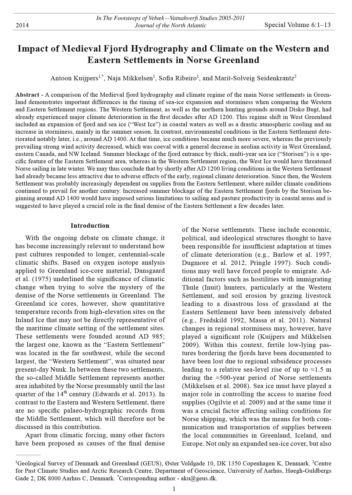
Figure 1. Overview of Norse
settlement remains in the
Western Settlement (“Vesterbygden”)
and Eastern Settlement
(“Østerbygden”).The
map (after Arneborg and Grønnow
2006) also shows the location
of the analyzed marine
sediment cores in Ameralik,
Western Settlement, and Igaliku
Fjord, Eastern Settlement.
References to the respective
core studies are referred to in
the text (see Data Sources).
The small insert map of Greenland
shows the geographic
setting of the settlements and
northern hunting grounds as
well as the ocean surfacecurrent
pattern and location
of the offshore sediment core
southwest of Disko Bugt (Ribeiro
et al. 2012). Core positions
are marked by an asterisk.
The darker colored area
in the surroundings of Disko
outlines the “Northern hunting
grounds” (“Nordsetur”). WS
= Western Settlement; ES =
Eastern Settlement.
Journal of the North Atlantic
A. Kuijpers, N. Mikkelsen, S. Ribeiro, and M.-S. Seidenkrantz
2014 Special Volume 6
3
al. 2011). Summer seasons are characterized by discharge
of cold freshwater from the Inland Ice prevailing
at the surface, while basin and deep waters of the
fjord, particularly during winter season, are characterized
by intermittent dense inflows from the (outer)
shelf and upper continental slope (Mortensen et al.
2011). These inflows are sourced in the West Greenland
Current (WGC; see Fig. 1, insert map), which
entrains a mixture of cold, low-salinity Polar Water
derived from the East Greenland Current (EGC)
and warmer, saline Atlantic Water originating from
the Irminger Current (IC) (e.g., Buch 2000, Cuny et
al. 2002). Thus, the WGC is an important agent for
northward advection of ocean heat along the West
Greenland coast (Zweng and Münchow 2006).
Present-day sea ice in the fjords is formed only
for brief periods during the coldest winters and under
light wind conditions (Bennike 2004). Particularly
during high-pressure weather situations in winter,
very strong (>10 Bft) katabatic winds may develop,
blowing from the Inland Ice towards the sea and
causing sudden extreme warming due to the foehn effect.
Fast ice in the inner part of the fjord breaks up in
May–June, which occurs in a period when winds are
observed to change their prevailing direction from
out-fjord to in-fjord (Mortensen et al. 2011), preventing
a large-scale flushing of the ice to open waters.
Offshore, the Davis Strait southern limit of the West
Ice (“Vestisen”) normally extends from Disko Bugt
in a southwesterly direction towards Canada, i.e.,
it remains well north of the Nuuk area. However, as
demonstrated in the winter of 2011–2012, the sea-ice
limit may occasionally reach the latitude of Nuuk, or
even further south (Fig. 2). The modern (1961–1990)
climate of Nuuk is low Arctic with a mean annual
air temperature of -1.4 °C and 752 mm precipitation
(Cappelen et al. 2001). During calm summer weather,
the funneling effect of the fjord topography may
lead to strengthening of the sea breeze. More generally,
active cyclone passages may lead to storm winds
from a prevailing southwestern direction.
Eastern Settlement
The hydrography of the fjords in the Eastern
Settlement area is characterized by the presence
of cold, low-salinity surface-water masses from
the EGC (Fig. 1) entering the outer fjord, whereas
at depths below ≈200 m, relatively warm (up to 4
°C) and saline Atlantic water derived from the IC
is found (Horsted 1956). A seasonal trend reveals
the dominance of cold EGC water masses until
late summer and an increased influence of Atlantic
water prevailing until early winter. In the inner part
of Igaliku Fjord, where our palaeo-hydrographic
reconstructions were made, freshwater discharge
from the Inland Ice is significant, and lower salinities
are found over almost the entire water column.
The outer fjord has no shallow sill, and the seabed
gradually deepens seaward (Herman et al. 1972).
Several islands separate the inner parts from the
outer Igaliku fjord, limiting water-mass exchange
and creating more uniform conditions in the inner
part of the fjord. Here, the hydrographic conditions
are largely determined by the current pattern of the
upper 100 m and by local air temperatures (Horsted
1956). During normal winter conditions, a sea-ice
cover is restricted to the innermost part of the fjord
and adjacent embayments. In the outer part of Igaliku
Fjord, multi-year, polar pack ice (“Storisen”;
Fig. 3) entrained by the EGC is present during
several months, normally from late winter or early
spring until early to mid-summer. In the area around
Cape Farewell, the concentration of this drift ice is
greatest between February and June (Buch 2000).
The climate of the Eastern Settlement is subarctic
with a more sub-continental regime prevailing
in the inland areas, whereas coastal areas experience
more maritime conditions. Weather conditions
can change drastically in relation to the respective
passage of warm- and cold-front zones of major
Atlantic cyclone systems on their easterly track following
the oceanic Polar Front zone south of Cape
Farewell. The strongest storms normally occur during
winter and enter into this area from a southeasterly
direction. In addition, particularly in winter and
early spring, the area is occasionally exposed to very
strong katabatic winds from a predominantly northeasterly
direction that influence erosion and aeolian
deposition patterns and prevent the formation of
more extensive sea ice in the fjord (Jacobsen 1987).
Data Sources
The palaeo-environmental information used in
our study is based on our investigations carried out
in the fjords or adjacent coastal waters of both the
Western Settlement (Møller et al. 2006, Ribeiro et al.
2012, Seidenkrantz et al. 2007) and Eastern Settlement
(Jensen et al. 2004, Lassen et al. 2004, Roncaglia
and Kuijpers 2004). For the Eastern Settlement,
these previously published results are supported by
onshore studies reported by Kuijpers and Mikkelsen
(2009) and Mikkelsen et al. (2008) dealing with aeolian
activity and relative sea-level rise, respectively.
As previously stated, the area around the Middle
Settlement has so far not been the target of our fjord
investigations and will therefore be excluded from
further discussion.
Journal of the North Atlantic
A. Kuijpers, N. Mikkelsen, S. Ribeiro, and M.-S. Seidenkrantz
2014 Special Volume 6
4
Regional Climate Complexity
In contrast to the general global warming trend
of the late 20th century, cooling has in fact been
observed in coastal southwestern Greenland (Hanna
and Cappelen 2003). The authors found that this
could only partly be explained by the large-scale atmospheric
circulation pattern associated with a positive
North Atlantic Oscillation (NAO; Hurrell 1995)
mode. Moreover, a cooling trend had already started
in the 1940s in eastern Canada (Kaspar and Allard
2001), which clearly predated the transition to a
positive NAO regime later in the 20th century. Thus,
Figure 2. Extent
of the “West Ice”
(“Vestisen”) in
Baffin Bay and
the northern Labrador
Sea reaching
far south into
coastal waters
south of Nuuk,
early March 2012
(Ice Service,
Danish Meteorological
Institute).
Various sea-ice
classes and types
(e.g., thickness,
coverage, etc.)
are indicated by
the standard sea
ice “egg” symbols
of the World
Meteorological
O rg a n i s a t i o n
(see also Fig. 3).
Journal of the North Atlantic
A. Kuijpers, N. Mikkelsen, S. Ribeiro, and M.-S. Seidenkrantz
2014 Special Volume 6
5
apparently a complex relation exists between the
Labrador Sea region in the west and the North Atlantic
region further to the east. An air-temperature
“seesaw” during winter between West Greenland
and northern Europe was first reported in AD 1765
(van Loon and Rogers 1978). This early observation
of the effect of the now well-known phenomenon
of the NAO was reported in a diary of Hans Egede
Saabye, who was a missionary in Greenland during
the late 18th century. He wrote: “In Greenland, all
winters are severe yet they are not all alike. The
Danes have noticed that when the winter in Denmark
was severe, as we perceive it, the winter in Greenland
in its manner was mild, and conversely.” Such
North Atlantic regional climate complexity is also
underlined by the study of Dawson et al. (2003), who
report the absence of a low-temperature extreme in
the Greenland GISP2 ice-core record between AD
1650 and 1710, the period when the “Little Ice Age”
(LIA) cooling was at its maximum in Europe. Also,
on longer time scales, accumulating evidence points
to more persistent, centennial-scale regional contrasts
in marine climate conditions when comparing
the Labrador Sea and Davis Strait region with the
Northeast Atlantic region (Krawczyk et al. 2010;
Ribeiro et al. 2012; Seidenkrantz et al. 2007, 2008).
Such a regionally complex pattern thus seems also
to have existed for the Medieval (warm) Climate
Anomaly (MCA) and its intervening cooling episodes.
The timing of the transition to the generally
colder LIA regime likewise appears not to have been
synchronous across the North Atlantic (e.g., Dawson
et al. 2003).
Within the above context, it is important to note
the location of the Western and Eastern Settlements
with regard to dominant patterns of cyclone activity.
The Western Settlement is mainly affected by the
behavior of the low-pressure “Baffin Bay Trough”
(Williams and Bradley 1985), whereas the Eastern
Settlement is strongly exposed to the frontal passages
associated with major North Atlantic cyclone
systems on their (north-) easterly tracks south of
Cape Farewell. Thus, with this background information,
the question arises as to how much the Medieval
hydrographic and climatic conditions of the
Western Settlement may have differed from those
which prevailed in the Eastern Settlement, a possibly
important factor when trying to explain the different
timing for the demise of the two settlements
(e.g., Barlow et al. 1997, McGovern 1991).
Figure 3. Areal distribution of multi-year pack ice (“Storisen”) entrained by the East Greenland Current that blocked the fjord
entrances of the Eastern Settlement area, 11–12 May 2012 (Ice Service, Danish Meteorological Institute). With the gradual retreat
of the West Ice, coastal waters offshore West Greenland had meanwhile become ice-free all the way up to Disko.
Journal of the North Atlantic
A. Kuijpers, N. Mikkelsen, S. Ribeiro, and M.-S. Seidenkrantz
2014 Special Volume 6
6
Widespread sea-ice cover in the fjord after ca. AD
1200 is also suggested by an increasing sand size
fraction. Gravel-sized and coarser material typically
produced by ice rafting processes, including glacial
ice in the form of drifting icebergs, is, however,
lacking in the marine sediment cores (Møller et al.
2006).
The timing of this environmental change is part
of a major re-organization of the entire North Atlantic
circulation regime, and presumably linked to a
centennial-scale climate shift at inter-hemispheric
scale (Kuijpers et al. 2009). Offshore West Greenland,
evidence has been found for increased primary
productivity prevailing from around AD 1250 until
shortly after AD 1500 (Ribeiro et al. 2012), which
is the time of more extreme LIA cooling referred to
above. This enhanced productivity can be explained
by upwelling processes along the Baffin sea-ice edge
moving southward at that time. Within this context,
it should be noted that the core site referred to in
Ribeiro et al. (2012) is located on the open shelf well
outside the normal reach of the annually forming local
sea-ice cover within Disko Bugt. Alternatively,
the increased productivity signal may be interpreted
to reflect stronger wind-induced surface-water mixing
during the plankton-blooming season in (early)
summer. An increase in aeolian activity between AD
1280 and 1410 is supported by studies of aeolian
deposits related to West Greenland valley-sandurs
(Willemse et al. 2003). This period appears to represent
the transitional stage from the MCA into the
LIA in West Greenland.
Thus, it appears that environmental conditions in
the Western Settlement area had already deteriorated
around or shortly after AD 1200. This change thus
included a drastic expansion of sea ice in the fjords,
implying a cold winter climate with a low storm frequency.
In contrast, combined evidence from aeolian
deposits (Willemse et al. 2003) and offshore environmental
records (Ribeiro et al. 2012) demonstrates
increased storminess, which consequently must have
been concentrated in the warmer season. This scenario
may also imply a higher spring–autumn snowstorm
frequency and repeated thawing and freezing,
which must have been devastating for livestock and
crops as these are entirely dependent on growing
and grazing conditions during the warmer part of the
year.
Eastern Settlement
The fjord hydrography of the Eastern Settlement
was characterized between AD 885 and ca. AD 1250
by intensive mixing of the water column and associated
increased productivity (Lassen et al. 2004,
Medieval Hydrography and Climate
Western Settlement
Palaeo-oceanographic investigations have shown
that at the time of arrival of the first Norse settlers
(ca. AD 1000), hydrographic conditions in the fjords
of the Western Settlement were characterized by reduced
bottom-water ventilation due to limited inflow
of saline water masses (subsurface) sourced in the
WGC, presumably as a consequence of significant
melt-water outflow and reduced contribution of IC
water to the WGC (Seidenkrantz et al. 2007). Enhanced
freshwater discharge from the West Greenland
Inland Ice margin at that time is also indicated
by a retreat of the Jacobshavn Isbræ in Disko Bugt
(Lloyd 2005), i.e., the main northern hunting ground
for the Norse (for location, see Disko in Fig. 1 insert
map). Under calm winter weather, low salinity of
the surface waters in the fjords must have favored
the occasional growth of a fjord sea-ice cover as
reported by Seidenkrantz et al. (2007). The WGC
over the shelf further offshore, however, appears to
display generally warmer conditions between the
time of Norse arrival and ca. AD 1250 (Ribeiro et al.
2012), which is followed here by increasing cooling
towards the onset of the LIA. This conclusion
is supported by alkenone-based palaeo-temperature
estimates of West Greenland lake records (D’Andrea
et al. 2011) showing an abrupt temperature decline
beginning near AD 1200 with a temperature decrease
of 4 °C within about 80 years.
At approximately the same time, the fjord environment
of the Western Settlement drastically
changed. Sea-ice formation became widespread
along with increased water-column stratification.
This change can be ascribed to an enhanced influx
of saline, WGC-derived subsurface water concurrent
with a surface melt-water outflow (Seidenkrantz et
al. 2007, 2009). In addition, another important factor
required for the formation of widespread ice in
the fjords is calm weather and the absence of strong
katabatic winds that otherwise would drive the ice
seaward out of the fjords. A decrease in melt-water
discharge is also indicated by the lower counts of the
chemical elements potassium (K) and titanium (Ti)
(Seidenkrantz et al. 2007), both representing detrital
minerals of continental origin. Lake records from
the area (D’Andrea et al. 2011, Olsen et al. 2012)
indicate persisting lower temperatures until approx.
AD 1380. This scenario is confirmed by the K and
Ti data referred to above showing a marked K and Ti
peak at ca. AD 1400 suggesting a short-term return
to warmer climate at that time. A renewed and significant
decrease in K and Ti counts reflects a transition
into the following, more extreme LIA cooling.
Journal of the North Atlantic
A. Kuijpers, N. Mikkelsen, S. Ribeiro, and M.-S. Seidenkrantz
2014 Special Volume 6
7
happened concurrent with an increased influx of Atlantic-
derived subsurface water (Lassen et al. 2004),
somewhat resembling the hydrographic scenario
previously described for the Western Settlement
fjords (e.g., Seidenkrantz et al. 2007). It is assumed
that this change also represents a major increase in
the duration of the blockage of the fjord entrance
by annual multi-year sea (Figs. 3, 4). This change
coincided with a general decrease in wind activity in
the area, an aeolian pattern also recognized in South
Greenland lake deposits (Andresen et al. 2004) and
in records of storm activity from northwest Iceland
(Andresen et al. 2005). During the preceding time
span, i.e., between ca. AD 850 and AD 1370, eastern
Canada was also affected by strong cyclone activity
(Kaspar and Allard 2001). In contrast, the ice-core
deuterium record from central Greenland shows that
here storm frequencies did increase after AD 1400,
presumably as a consequence of a major re-organization
in atmospheric circulation dated at about AD
1420 (Mayewski et al.1993, Meeker and Mayewski
2002). As the main North Atlantic extra-tropical
cyclone tracks tend to follow the ocean polar front
zone, it thus seems that the Eastern Settlement
experienced pronounced changes in ice and wind
conditions associated with the latter large-scale shift
in atmosphere-ocean interaction patterns, which occurred
about two centuries after the West Greenland
regime shift.
Discussion and Conclusion
The specific climatic and hydrographic responses
to the transitional period between the MCA and
LIA are notably different for the Western and Eastern
Settlements (Table 1). This fundamental difference
in the climatic and environmental history
of the two settlements is proposed to have played
a crucial role for the timing of the demise of the
respective settlements. Here it must be underlined
that this does not imply that factors of societal and
economic relevance could not also have played a
further, important role (e.g., Dugmore et al. 2012).
As previously mentioned, the presence of sea ice
during longer periods can be assumed to have had
a serious impact on the Norse. Apart from imposing
hazards to regional and transatlantic sailing, fishing
and hunting of marine mammals would also be affected.
In addition, the production potential of low-
Roncaglia and Kuijpers 2004). Significant bottomwater
ventilation is characteristic for most of this
period, i.e., AD 960–1285, with a peak oxygenation
event dated at ca. AD 1125 (Roncaglia and Kuijpers
2004). The latter authors further documented an
increased influx of terrestrial leaf tissue, suggesting
an important material input by wind transport or
freshwater run-off processes. A reduction in local
pollen fluxes (Jessen et al. 2011) suggests a change
in wind pattern or run-off conditions close to AD
1200, i.e., at the time of the marked regime shift in
West Greenland coastal areas (Nørgaard-Pedersen
and Mikkelsen 2009). Onshore studies of aeolian deposits
confirm that MCA wind activity was strongest
after AD 1000, reaching a maximum close to AD
1300 (Kuijpers and Mikkelsen 2009), after which
the atmospheric circulation intensity in this area decreased.
The marine evidence of strong, atmospherically
induced surface-water mixing suggests that
erosion around the Eastern Settlement during the
Norse period may thus have been primarily related
to increased wind strength instead of being attributable
to farming activities (e.g., Jacobsen 1991). Lake
records document decreasing agro-pastoral activities
during the Norse era (Massa et al. 2011), which
supports a shift in diet toward other, increasingly
marine resources (Arneborg et al. 1999). Enhanced
wind-induced water-mass mixing favoring marine
primary production during the latter part of the
Norse era can be assumed to have had positive effects
on the fish and marine mammals standing stock
in the fjords, making fishing and hunting here more
profitable.
More generally, the hydrographic reconstruction
in Igaliku Fjord reveals two major climate regimes:
i.e., the MCA between ca. AD 800 and AD 1250 and
the LIA between ca. AD 1580 and AD 1850, separated
by a variable transitional period (Jensen et al.
2004). Cold, ice-loaded EGC water masses did not
significantly affect the area prior to about AD 1400.
This scenario based on diatom data is confirmed by
the foraminiferal studies of Lassen et al. (2004),
who document a first cooling step culminating at
AD 1405. Jensen et al. (2004) report that since the
arrival of the Norse, sea-ice formation in the fjords
had been very limited. A marked change occurred
around AD 1435 as the Igaliku Fjord was flooded
by cold, EGC-derived surface-water masses and
fjord ice expanded (Jensen et al. 2004). This shift
Table 1. Timing of Medieval ice- and wind-regime shift in the Greenland Norse settlements.
Western Settlement Eastern Settlement
Widespread fjord ice formation starting ca. AD 1200 ca. AD 1400
Enhanced aeolian activity/storminess ca. AD 1250–1410 (1500) spring-summer-autumn ca. AD 900–1370 (1420) all-season?
Journal of the North Atlantic
A. Kuijpers, N. Mikkelsen, S. Ribeiro, and M.-S. Seidenkrantz
2014 Special Volume 6
8
Figure 4. Aerial photographs illustrating belts of dense, multi-year pack-ice (“Storisen”) blocking South Greenland fjord
entrances in the Eastern Settlement area (Ice Service, Danish Meteorological Institute). Photograph A provides an overview
of long stretches of Storisen extending along the coast, whereas photograph B illustrates in more detail the potential hazards
for small vessels when attempting to navigate in this type of dense drift ice.
Journal of the North Atlantic
A. Kuijpers, N. Mikkelsen, S. Ribeiro, and M.-S. Seidenkrantz
2014 Special Volume 6
9
land pastures adjacent to (summertime) ice-filled
fjords is known to be significantly reduced due to
the ice-cooling effect on the near-field air temperature
regime, which during calm weather often leads
to the formation of fog.
In the present day, a marked difference in sea-ice
formation and pack-ice drift can be noted for the
areas of the Western and Eastern Settlements. Due to
the warming effect of the WGC, and particularly the
occurrence of strong katabatic winds during winter,
the region of Nuuk is today normally characterized
by the absence of locally formed, coastal sea ice of
any significance. The seldom occurrence of more
extensive sea ice along the coast (see Fig. 2) is the
result of advection of the West Ice in late winter, a
process strongly controlled by the prevailing wind
pattern, which depends on the actual position of the
“Baffin Bay Trough” and large-scale NAO regime.
These conditions are in marked contrast to those
prevailing in the Eastern Settlement area, where
from late winter to midsummer large amounts of
thick, multi-year drift ice (“Storisen”) entrained by
the East Greenland Current can block the entrance of
the fjord systems (Fig. 4). This blockage occurred,
for instance, in 1995, as drift ice appeared as early as
January and reached as far as 250 km south of Cape
Farewell. In 1970, the fjord entrance did not become
ice-free until August (Centre for Ocean and Ice,
Danish Meteorological Institute). Previous observations,
i.e., in the mid-19th century, have documented
this Storisen blockage persisting all through the
summer and on into late autumn (Fig. 5), a situation
which may have been not uncommon during the preceding
Little Ice Age.
Deterioration of the ice situation in Igaliku fjord
around AD 1400 may be linked to a significant increase
of drift ice entrained by the East Greenland
Current, as is supported by historical observations
made on Iceland (Ogilvie 1984). Before AD 1400,
intense wind-induced surface-water mixing of both
Greenland coastal waters and inner fjord waters
(Kuijpers and Mikkelsen 2009, Lassen et al. 2004)
suggest a largely ice-free fjord system during most
of the year. This situation is in marked contrast
to the ice conditions in the fjords of the Western
Settlement prior to AD 1400. Here, a major shift
in the hydrography of the fjords with the formation
of a more extensive sea-ice cover in the fjords (Seidenkrantz
et al. 2007) and an abrupt atmospheric
cooling (D’Andrea et al. 2011) had already occurred
shortly after AD 1200. Offshore sailing and hunting
conditions in the northern hunting ground area (see
Fig. 1) presumably also deteriorated, as suggested
by southward expansion of the Baffin Bay sea ice
after ca. AD 1250 and increased storminess during
the warmer season based on combined onshore and
offshore evidence (Ribeiro et al. 2012, Willemse
et al. 2003). In contrast, expanding sea ice in the
fjords implies a lower frequency of katabatic wind
episodes during winter, i.e., an altered atmospheric
pressure regime. Adverse ice and weather conditions
during spring and summer, respectively, affecting
the northern hunting grounds around Disko Bugt
may have led to losses not only in terms of food
supply, but also in terms of the economy. Resources
(e.g., walrus ivory) from this area had been an important
export to Europe, but the increasingly harsh
weather conditions made this hunting and trade less
profitable at a time when prices in Europe for walrus
ivory were also decreasing (Guérin 2010).
This early expansion of Baffin Bay sea ice was
notably coeval with a general increase of the Arctic
Ocean sea-ice cover during the period AD 1200 to
AD 1450 (Kinnard et al. 2011). As a consequence,
after AD 1200, sea-ice export from the Arctic via the
East Greenland Current and Canadian archipelago
may also have increased, as observed on Iceland
(Ogilvie 1984). The regime shift recorded in West
Greenland around AD 1200 appears to have been
part of an Atlantic-wide, large-scale re-organization
of ocean and atmosphere circulation (Kuijpers et
al. 2009). The hydrographic and climatic implications
of this early shift were, however, initially less
pronounced in southernmost Greenland. Apart from
a slight increase in the advection of EGC waters into
Igaliku Fjord (Jensen et al. 2004) and an apparently
Figure 5. Scan of a table (Fritz 1881) reporting observed
variations in the duration of dense, multi-year pack-ice
(“Storisen”) blockage of southwest Greenland fjords during
the period 1867–1879. Note the extreme long period of
blockage in 1868 lasting until November, a situation which
may have been not uncommon during the preceding “Little
Ice Age”, i.e., the period after ca. AD 1400.
Journal of the North Atlantic
A. Kuijpers, N. Mikkelsen, S. Ribeiro, and M.-S. Seidenkrantz
2014 Special Volume 6
10
in atmospheric circulation (wind pattern) over the
Davis Strait and Baffin Bay, which must have had
an important effect on both sea-ice formation in the
fjords of the Western Settlement and particularly, on
the drift pattern of “West Ice” (Vestisen) offshore
West Greenland. This shift seems to have occurred
at an early stage concurrent with the expansion of
Arctic sea ice (Kinnard et al. 2011). The transatlantic
cyclone belt from eastern Canada towards Iceland
thus moved gradually south, and even at this initial
stage, the shift from strongly zonal (NAO+) to a
more frequent meridional atmospheric circulation
(NAO-) regime must have had an immediate impact
on Baffin Bay atmospheric circulation and the position
of the Baffin Bay trough.
With a major decrease in storminess over southernmost
Greenland coinciding with a significant
expansion of ice-loaded Polar water masses around
AD 1400, the Eastern Settlement would also have
been affected by a major, long-term environmental
change. This change would include widespread ice
formation in the fjords and presumably a markedly
increased summer blockage of the fjord entrance by
multi-year Polar drift ice. The latter is suggested
by a significantly enhanced influx of EGC polar
surface-water masses reaching also the inner parts of
Igaliku Fjord (Jensen et al. 2004). The demise of the
Eastern Settlement in the mid-fifteenth century (Arneborg
et al. 1999) thus occurred relatively fast, i.e.,
only a few decades after the summer ice-blockage
situation had severely deteriorated. In contrast, the
population in the Western Settlement had survived
for roughly a century after they had been confronted
with a marked deterioration of the winter ice conditions
and cooling in combination with a more
stormy summer weather climate towards the end of
their settling history. One possible explanation for
this much shorter period until the final demise of
the Eastern Settlement may be that during a large
part of the summer season the fjord entrance to the
Eastern Settlement was blocked by Storisen, which
made small-vessel shipping in and out of the Eastern
Settlement extremely risky or impossible (Fig.
4). Moreover, with the summer pack ice and calmer
weather, the probability of days with coastal fog due
to cooling of warmer air masses advected over the
pack ice zone may also have increased, another factor
adding to navigational risks.
A similar physical threat by pack ice to maritime
transport during summer most likely did not exist
at the Western Settlement, but after AD 1200, the
living conditions here had already become more and
more unattractive due to the adverse effects of the
early climate deterioration in this region. During
minor change in prevailing wind direction or precipitation
regime suggested by a marine pollen record
(Jessen et al. 2011), no drastic change in the general
ice situation or climate regime can be noted here at
that time.
More generally, the regional complexity of
reconstructing large-scale changes of ocean and
atmospheric circulation has been clearly illustrated
by Dawson et al. (2003), who found that LIA storminess
as recorded at the central Greenland GISP2 icecore
site was not coincident with the stormiest winters
of the last millennium known from Iceland and
Western Europe. This pattern is also evident from
marine sediment records obtained from the fjord entrance
to the Eastern Settlement (Nørgaard-Pedersen
and Mikkelsen 2009) and thus also applies to the
low-elevation areas of our study where periods of
aeolian activity were not completely synchronous.
Storminess in southernmost Greenland was notably
coincident with storminess in eastern Canada
(Kaspar and Alard 2001) and NW Iceland (Andresen
et al. 2005). Maximum aeolian activity in the
Eastern Settlement close to AD 1300 (Kuijpers and
Mikkelsen 2009) was, however, concurrent with the
West Greenland storminess peak (AD 1280–1410)
recorded by Willemse et al. (2003) and may result
from a combination of frequent outbreaks of cold,
polar air masses and relatively warm sea-surface
conditions promoting strong atmospheric instability
and cyclone genesis.
A positive ocean surface-temperature anomaly
that developed after AD 1200 has been found to
characterize waters around southern Greenland
and large parts of the sub-polar gyre including the
Irminger Sea and the northeastern Labrador Sea
(Andresen et al. 2012, Krawczyk et al. 2013, Miettinen
et al. 2012, Seidenkrantz et al. 2007). In addition,
Gulf Stream temperatures off the northeastern
US were anomalously high (Van der Schrier and Weber
2010). Miettinen et al. (2011) could demonstrate
for the later, coldest part of the LIA, a systematic
negative correlation between reconstructed positive
SST anomalies recorded in the central North Atlantic
south of Iceland and negative NAO conditions.
This correlation is confirmed by other evidence
(Van der Schrier and Barkmeijer 2005) showing that
during periods of anomalously LIA cold in Western
Europe, for example during the so-called “Dalton
(solar) Minimum” (AD 1790–1820), the North
Atlantic extra-tropical cyclone belt was displaced
to the south, a typical feature of a negative NAO
circulation regime. A trend towards more negative
NAO patterns after AD 1200 (Kuijpers et al. 2009,
Trouet et al. (2009) implies an important change
Journal of the North Atlantic
A. Kuijpers, N. Mikkelsen, S. Ribeiro, and M.-S. Seidenkrantz
2014 Special Volume 6
11
summer and early autumn, sufficient supplementary
supplies for daily subsistence could probably still be
provided through shipping support from the Eastern
Settlement. This supplementation may have included
food, (winter) fodder for domestic animals and
fuel for heating. Such a scenario would simultaneously
contribute to the interpretation of preliminary
results from lead isotope studies (Frei 2012), which
show that the Western Settlement Norse have a lead
isotope composition representative of the Eastern
Settlement geological background. Within this context,
it may not be a coincidence that the final demise
of the Western Settlement is dated in the years
around AD 1350 (Barlow et al. 1997, Pringle 1997),
which in the northern North Atlantic represents an
episode characterized by a series of extremely severe
winters and very cold summers (Stuiver et al.
1995). Such a climatic regime suggests that in the
Eastern Settlement area, which is more directly influenced
by North Atlantic climate, grass harvesting
during these years would have been at a minimum,
leading to a local shortage with no excess supplies
of fodder and fuel available for any further support
of the Western Settlement.
Acknowledgments
This is a contribution to the TROPOLINK and
OCEANHEAT projects funded by the Danish Council
for Independent Research/Natural Science (FNU Grants
09-069833 and 12-126709, AKU and MSS), the EU FP7
project “Past4Future” (Project No. 243908, MSS), and
former projects funded by FNU/SNF (Grants 9701901 and
9802945, AKU et al.) as well as the Nordic Arctic Research
Programme (NM). The German Research Council (“DFG”)
is gratefully acknowledged for having funded the research
cruises of RV Poseidon (1998), Alexander von Humboldt
(2002), and Maria S. Merian (2007), during which the
respective cores discussed in this study were collected.
Furthermore, the Commission for Scientific Research in
Greenland, the Royal Greenland Foundation, and the Bikuben
Foundation are thanked for financial support of the
Greenland leg (2006) of the Danish Galathea3 Expedition.
Special thanks are due to Dr. Gerd Hoffmann-Wieck (IfMGeomar
Kiel) and Prof. Jan Harff (IOW Warnemünde)
for their crucial role in German ship-time application
procedures and organizational efforts related to respective
(1998–2002, 2007) cruises. We thank the Ice Service, Centre
for Ocean and Ice at the Danish Meteorological Institute,
for the aerial photographs used in this contribution.
Literature Cited
Andresen, C.S., S. Björck, and G. Bond. 2004. Holocene
climate changes in southern Greenland: Evidence
from lake sediments. Journal of Quaternary Science
19:783–795.
Andresen, C.S., G. Bond, A. Kuijpers, P.C. Knutz, and
S. Björck. 2005. Holocene climate variability and
multidecadal time-scales detected by sedimentological
indicators in a shelf core NW off Iceland. Marine
Geology 214:323–338.
Andresen, C.S., M. Hansen, M.-S. Seidenkrantz, A.E. Jennings,
M.F. Knudsen, N. Nørgaard- Pedersen, N. Larsen,
A. Kuijpers, and C. Pearce. 2012. Late Holocene
oceanographic variability on the Southeast Greenland
shelf. The Holocene doi: 10.1177/0959683612460789.
Arneborg, J., and B. Grønnow (Eds.). 2006. Dynamics of
Northern Societies. National Museum, Copenhagen,
Denmark. 415 pp.
Arneborg, J., J.Heinemeier, N. Lynnerup, L.H. Nielsen,
N, Rud, and A.E. Sveinbjørnsdottir.1999. Change of
diet of the Greenland Vikings determined from stable
carbon isotope analysis and 14C dating of bones. Radiocarbon
41:157–168.
Barlow, L.K., J.P. Sadler, A.E.J. Ogilvie, P.C. Buckland,
T. Amorosi, J.H. Ingimundarson, P. Skidmore, A.J.
Dugmore, and T.H. McGovern. 1997. Interdisciplinary
investigations of the end of the Norse Western Settlement
in Greenland. The Holocene 7:489–499.
Bennike, O. 2004. Holocene sea-ice variations in Greenland:
Onshore evidence. The Holocene 14:607–613.
Buch, E. 2000. A monograph on the physical oceanography
of the Greenland waters. Danish Meteorological
Institute, Copenhagen, Denmark. Scientific Report
00-12. 405 pp.
Cappelen, J., B.V. Jørgensen, E.V. Laursen, L.S. Stannius,
and R.S.Thomsen. 2001. The observed climate of
Greenland, 1958–1999 with climatological standard
normals, 1961–1990. Danish Meteorological Institute,
Copenhagen, Denmark. Report 00-18. 115 pp.
Cuny, J., P.B. Rhines, P.P. Niiler, and S. Bacon. 2002.
Labrador Sea boundary currents and the fate of the
Irminger Sea Water. Journal of Physical Oceanography
32:627–647.
D’Andrea, W.J., Y. Huang, S.C. Fritz, and N.J. Anderson.
2011. Abrupt Holocene climate change as an important
factor for human migration in West Greenland. PNAS
108 (24):9765–9769.
Dansgaard, W., S.J. Johnsen, N. Reeh, N. Gundestrup,
H.B. Clausen, and C. Hammer. 1975. Climatic changes,
Norsemen, and modern man. Nature 255:24–28.
Dawson, A.G., L. Elliott, P. Mayewski, P. Lockett, S.
Noone, K. Hickey, T. Holt, P. Wadhams, and I. Foster.
2003. Late Holocene North Atlantic climate seesaws,
storminess changes, and Greenland ice sheet (GISP2)
palaeoclimates. The Holocene 13:381–392.
Dugmore, A.J., T.H. McGovern, O. Vésteinsson, J. Arneborg,
R. Streeter, and C. Keller. 2012. Cultural
adaption, compounding vulnerabilities, and conjunctures
in Norse Greenland. PNAS 109(10):3658–3663.
Edwards, K.J., G.T. Cook, G. Nyegaard, and J.E. Schofield.
2013. Towards a first chronology for the Middle
Settlement of Norse Greenland: 14C and related studies
of animal bone and environmental material. Radiocarbon
55(1):13–29.
Fredskild, B. 1992. Erosion and vegetational changes in
South Greenland caused by agriculture. Geografisk
Tidskrift 92:14–21.
Journal of the North Atlantic
A. Kuijpers, N. Mikkelsen, S. Ribeiro, and M.-S. Seidenkrantz
2014 Special Volume 6
12
Frei, D. 2012. Lead isotopes and the Viking Colonization
of the North Atlantic. Paper presented at the Vatnahverfi
Workshop, National Museum, Copenhagen, Denmark.
21–22 March 2012.
Fritz, S. 1881. Nogle Iagttagelser om Isforholdene
paa Grønlands Sydvestkyst. Geografisk Tidsskrift
5:78–81.
Guérin, S.M. 2010. Avorio d’ogni ragione: The supply of
elephant ivory to northern Europe in the Gothic era.
Journal of Medieval History 36(2):156–174.
Hanna, E., and J.Cappelen. 2003. Recent cooling in
coastal southern Greenland and relation with the North
Atlantic Oscillation. Geophysical Research Letter
30(3), DOI:10.1029/2002GL015797.
Herman, Y., J. O’Neil, and C.L. Drake. 1972. Micropaleontology
and paleotemperature of postglacial SW
Greenland fjord cores. Pp 357–407, In Y. Vasari,
H. Hyvärinen, S. Hicks (Eds.). Climatic Changes in
Arctic Areas During the Last Ten Thousand Years,
University of Oulu, Geological Series A (1, 3), 469 pp.
Horsted, S.A. 1956. Hydrographic-biological investigations
of the southwest Greenland prawn grounds. Meddelelser
fra Danmarks Fiskeri- og Havundersøgelser,
Ny Serie 1:61–116.
Hurrell, J.W. 1995. Decadal trends in the North Atlantic
Oscillation and relationships to regional temperature
and precipitation. Science 269:676–679.
Jacobsen, N.K. 1987. Studies on soils and potential for
soil erosion in the sheep farming area of South Greenland.
Arctic and Alpine Research 19(4):498–507.
Jacobsen, B.H. 1991. Soil resources and soil erosion in
the Norse settlement area of Østerbygden in Southern
Greenland. Acta Borealia 1:56–68.
Jensen, K.G., A. Kuijpers, N. Koc, and J. Heinemeier.
2004. Diatom evidence of hydrographic changes and
ice conditions in Igaliku Fjord, South Greenland, during
the past 1500 years. The Holocene 14 (2):152–164.
Jessen, C.A., S. Solignac, N. Nørgaard-Pedersen, N.
Mikkelsen, A. Kuijpers, and M.-S. Seidenkrantz.
2011. Exotic pollen as an indicator of variable atmospheric
circulation over the Labrador Sea during the
mid- to late Holocene. Journal of Quaternary Science
26(3):286–296.
Kaspar, J.N., and M. Allard. 2001. Late Holocene climatic
changes as detected by the growth and decay of ice
wedges on the southern shore of Hudson Strait, northern
Québec, Canada. The Holocene 11(5):563–577.
Kinnard, C., C.M. Zdanowicz, D.A. Fisher, E. Isaksson,
A. de Vernal, and L.G. Thompson. 2011. Reconstructed
changes in Arctic sea-ice cover over the past 1450
years. Nature 479:509–512.
Krawczyk, D., A. Witkowski, M. Moros, J.M. Lloyd, A.
Kuijpers, and A. Kierzek. 2010. Late-Holocene interaction
between climate and hydrology of the West Greenland
Current from Disko Bugt, central West Greenland.
The Holocene doi:10.1177/0959683610371993.
Krawczyk, D., A. Witkowski, J.M. Lloyd, M.Moros, J.
Harff, and A. Kuijpers. 2013. Late-Holocene diatomderived
seasonal variability in hydrological conditions
off Disko Bay, West Greenland. Quaternary Science
Reviews 67:93–104.
Kuijpers, A., and N. Mikkelsen. 2009. Geological records
of changes in wind regime over South Greenland since
the Medieval Warm Period: a tentative reconstruction.
Polar Record 45(232):1–8.
Kuijpers, A., B.A. Malmgren, and M.-S. Seidenkrantz.
2009. Termination of the Medieval Warm Period:
Linking subpolar and tropical N-Atlantic circulation
changes to ENSO. PAGES News 17(2):76–77.
Lassen, S.J., A. Kuijpers, H. Kunzendorf, G. Hoffmann-
Wieck, N. Mikkelsen, and P. Konradi. 2004. Late
Holocene Atlantic bottom water variability in Igaliku
Fjord, South Greenland, reconstructed from foraminiferal
faunas. The Holocene 14(2):165–171.
Lloyd, J.M. 2005 Late Holocene environmental change in
Disko Bugt, West Greenland: Interaction between climate,
ocean circulation and Jakobshavn Isbræ. Boreas
35:35–49.
Massa, C., V. Bichet, É. Gauthier, B.B. Perren, O. Mathieu,
C. Petit, F. Monna, J. Giraudeau, R. Losno,
and H. Richard. 2011. A 2500-year record of natural
and anthropogenic soil erosion in South Greenland.
Quaternary Science Reviews doi:10.1016/j.quascirev.
2011.11.014.
Mayewski, P.A., L.D. Meeker, M.C. Morrison, M.S.
Twickler, S. Whitlow, K.K. Ferland, D.A. Meese,
M.R. Legrand, and J.P.Steffensen.1993. Greenland
ice-core signal characteristics: An expanded view
of climate change. Journal of Geophysical Research
98(D7):12839–12847.
McGovern, T.H. 1991. Climate, correlation, and causation
in Norse Greenland. Arctic Anthropology 28:77–100.
Meeker, L.D., and P.A.Mayewski. 2002. A 1400-year
high-resolution record of atmospheric circulation
over the North Atlantic and Asia. The Holocene
12:257–266.
Miettinen, A., N. Koc, I.R. Hall, F. Godtliebsen, and D.
Divine. 2011. North Atlantic sea-surface temperatures
and their relation to the North Atlantic Oscillation during
the last 230 years. Climate Dynamics 36:533–543.
Miettinen, A., D. Divine, N. Koc, F. Godtliebsen, and
I.R. Hall. 2012. Multicentennial variability of the
Sea Surface Temperature gradient across the subpolar
North Atlantic over the last 2.8 kyr. Journal of Climate
25:4205–4219.
Mikkelsen, N., A. Kuijpers, and J. Arneborg, J. 2008.
The Norse in Greenland and late Holocene sea-level
change. Polar Record 44(228):45–50.
Mortensen, J., K. Lennert, J. Bendtsen, and S. Rysgaard.
2011. Heat sources for glacial melt in a sub-arctic
fjord (Godthåbsfjord) in contact with the Greenland
Ice Sheet. Journal of Geophysical Research 116 (C1)
doi:10.1029/2010JC006528.
Møller, H.S., K.G. Jensen, A. Kuijpers, S. Aagaard-
Sørensen, M.-S. Seidenkrantz, M. Prins, R. Endler,
and N. Mikkelsen. 2006. Late Holocene environment
and climatic changes in Ameralik Fjord, southwest
Greenland. Evidence from the sedimentary record.
The Holocene 16(5):685–695.
Nørgaard-Pedersen, N., and N. Mikkelsen. 2009. A
8000-years marine record of climate variability and
fjord dynamics from Southern Greenland. Marine Geology
264:177–189
Journal of the North Atlantic
A. Kuijpers, N. Mikkelsen, S. Ribeiro, and M.-S. Seidenkrantz
2014 Special Volume 6
13
Research 59:322–344.
Williams, L.D., and R.S. Bradley. 1985. Paleoclimatology
of the Baffin Bay region. Pp. 741–772, In J.T. Andrews
(Ed.). Quaternary Environments of the Eastern Canadian
Arctic, Baffin Bay and Western Greenland. Allen
and Unwin, New York, NY, USA. 798 pp.
Zweng, M.M., and A. Münchow. 2006. Warming and freshening
of Baffin Bay, 1916–2003. Journal of Geophysical
Research 111 (C7) doi:10.1029/2005JC003093.
Ogilvie, A.E.J. 1984. The past climate and sea-ice record
from Iceland, Part I: Data to AD 1780. Climatic
Change 6:131–152.
Ogilvie, A.E.J. 2010. Historical climatology, climatic
change, and implications for climate science in the 21st
century. Climatic Change 100:33–47.
Ogilvie, A.E.J., J.M. Woollett, K. Smiarowski, J. Arneborg,
S. Troelstra, A. Kuijpers, A.Pálsdóttir, and
T.H. McGovern. 2009. Seals and sea ice in medieval
Greenland. Journal of the North Atlantic 2:60–80.
Olsen, J., N.J. Anderson, and M.F. Knudsen. 2012. Variability
of the North Atlantic Oscillation over the past
5200 years. Nature Geoscience 5:808–812.
Pringle, H.1997. Death in Norse Greenland. Science
275:924–926.
Ribeiro, S., M. Moros, M. Ellegaard, and A. Kuijpers.
2012. Climate variability in West Greenland during
the past 1500 years: Evidence from a high-resolution
marine palynological record from Disko Bay. Boreas
41:68–83.
Roncaglia, L., and A. Kuijpers. 2004. Palynofacies
analysis and organic-walled dinoflagellate cysts in late
Holocene sediments from Igaliku Fjord, South Greenland.
The Holocene 14(2):172–184.
Seidenkrantz, M.-S., S. Aagaard-Sørensen, H. Sulsbrück,
A. Kuijpers, K.G. Jensen, and H. Kunzendorf. 2007.
Hydrography and climate of the last 4400 years in a
SW Greenland fjord: Implications for Labrador Sea
palaeoceanography. The Holocene 17(3):387–401.
Seidenkrantz, M.-S., L. Roncaglia, A. Fischel, C. Heilmann-
Clausen, A.Kuijpers, and M. Moros. 2008.
Variable North Atlantic climate seesaw patterns documented
by a Late Holocene marine record from Disko
Bugt, West Greenland. Marine Micropaleontology
68:66–83.
Seidenkrantz, M.-S., A. Kuijpers, and T. Schmith. 2009.
Comparing past and present climate: A tool to distinguish
between natural and human-induced climate
change. IOP Conference Series, Earth and Environmental
Sciences 8 doi:10.1088/1755-1315/8/1/012012.
Stuiver, M., P.M. Grootes, and T.F. Braziunas. 1995. The
GISP2 δ18 O climate record of the past 16,500 years
and the role of the sun, ocean, and volcanoes. Quaternary
Research 44:341–354.
Trouet, V., J. Esper, N.E. Graham, A. Baker, J.D. Scourse,
and D.C. Frank. 2009. Persistent positive North Atlantic
Oscillation mode dominated the medieval climate
anomaly. Science 324:78–80.
van Loon, H., and J.C. Rodgers. 1978. The seesaw in
winter temperatures between Greenland and northern
Europe, Part I: General description. Monthly Weather
Review 106:295.
Van der Schrier, G., and J. Barkmeijer. 2005. Bjerknes’
hypothesis on the coldness during AD 1790–1820
revisited. Climate Dynamics 24:537–553.
Van der Schrier, G., and S.L. Weber. 2010. The Gulf
Stream and Atlantic sea-surface temperatures in AD
1790–1825. International Journal of Climatology
30:1747–1763.
Willemse, N.W., E.A. Koster, B. Hoogakker, and F.G.M.
van Tatenhove. 2003. A continuous record of Holocene
eolian activity in west Greenland. Quaternary