2108026 NOSoRuTtHheEaAstSeTrnE RNNa tNurAaTliUstR NAoLtIeSsT Vol. 8, No. 1
Downstream Intrabasin Range Extension for the Endangered
Plicate Rocksnail, Leptoxis plicata (Conrad) (Gastropoda:
Pleuroceridae)
Terry D. Richardson1,* and Jeff Selby2
Abstract - Two new locations were documented for Leptoxis plicata (Plicate Rocksnail), listed
as endangered by the US Fish and Wildlife Service in 1998. Plicate Rocksnail is endemic to the
Black Warrior River system in Alabama and was thought to be restricted to 15 shoals in a 30-km
reach of Locust Fork, all upstream of the US Highway 78 crossing. During a routine biological
survey, Plicate Rocksnail was found at two additional shoals downstream of the Highway 78
crossing: one 3.5 km (87°01'00"W, 33°41'30"N) and the other 5.2 km (87°00'30"W, 33°39'20"N)
downstream. The rocksnails were extremely abundant at each of these locations and varied in
size from small, apparently young of the year, to large adults. These two new locations extend
the intrabasin range of this species over 5 km farther downstream than previously reported.
Leptoxis plicata (Conrad) (Plicate Rocksnail) is a member of the freshwater snail
family Pleuroceridae and was listed as endangered by US Fish and Wildlife Service
in 1998 (US Fish and Wildlife Service 1998). Historically, this rocksnail occurred
throughout the Black Warrior River system of the Mobile River drainage in Alabama
(Johnson 2004). Plicate Rocksnail is a small to medium-sized pleurocerid growing to
a shell length of about 20 mm (Fig. 1). The shells are subglobose and have a broadly
rounded to ovate aperture that is usually bluish white to pink within. Whorls are
convex, shouldered, and often have a raised ridge on the shoulder. The body whorl
is frequently plicate. Shell color is typically brown to yellowish green and may have
Notes of the Southeastern Nat u ral ist, Issue 8/1, 2009
182
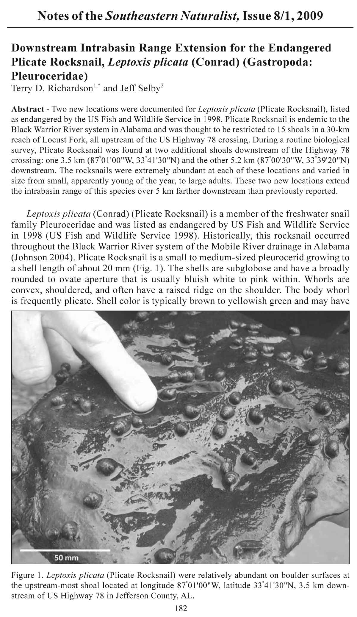
Figure 1. Leptoxis plicata (Plicate Rocksnail) were relatively abundant on boulder surfaces at
the upstream-most shoal located at longitude 87°01'00"W, latitude 33°41'30"N, 3.5 km downstream
of US Highway 78 in Jefferson County, AL.
2008 Southeastern Naturalist Notes 183
up to three equally spaced dark bands. Plicate Rocksnail is genetically distinct from
other congeners in the basin (Lydeard et al. 1997).
Plicate Rocksnail have disappeared from over 90% of their historic range. This
snail occurs in shoals with cobble, boulders, or bedrock, usually in less than one meter
of fl owing water (Johnson 2002). It is believed the distribution of the Plicate Rocksnail
declined over several decades due to the loss of these requisite shoal habitats throughout
the Mobile Basin (Garner 1990). During status surveys in the 1990s, the rocksnail was
found only in an 88-km reach of Locust Fork of the Black Warrior River in Jefferson and
Blount counties in Alabama (US Fish and Wildlife Service 2005). Since then, more recent
surveys have concluded that Plicate Rocksnail is restricted to 15 shoals in a 30-km
reach of Locust Fork (Johnson 2004), having disappeared from the upper portion of its
intrabasin range. This snail appears to be declining in the Locust Fork and is estimated to
have experienced a 50% reduction in range in the past decade. Causes for the relatively
recent decline of Plicate Rocksnail in Locust Fork are uncertain, but speculation has attributed
the decline to sedimentation, pollution, and altered hydrology (Johnson 2004,
US Fish and Wildlife Service 2005). Johnson (2002) suggests that many of the 15 known
populations may still be still on the decline.
Owing to its limited distribution and specific habitat requirements, there is concern
Plicate Rocksnail is at risk of extinction (US Fish and Wildlife Service 1998). Since its
listing in 1998, Plicate Rocksnail has become the subject of recovery efforts under the
Mobile Basin Recovery Plan (2000) and now under the Recovery Plan for Six Mobile
Basin Aquatic Snails (USFWS 2005). Even so, no formal monitoring plans have been
put into place to assess population stability of Plicate Rocksnail, and habitat threats still
remain. However, captive populations of Plicate Rocksnail have been successfully established
(US Fish and Wildlife Service 2006). As a result, hatchery-produced offspring
have been released into the Locust Fork in an effort to extend the range upstream into
areas where it had been extirpated. Initially, survival rates of these hatchery-raised juveniles
were extremely low (USFWS 2006), but more recent releases seem to have been
successful (P. Johnson, Alabama Department of Conservation and Natural Resources,
Figure 2. The upstream-most shoal located at longitude 87°01'00"W, latitude 33°41'30"N, 3.5
km downstream of US Highway 78 in Jefferson County, AL.
184 Southeastern Naturalist Notes Vol. 8, No. 1
Marion, AL, pers. comm.). Nonetheless, the discovery and subsequent documentation
of new locations is essential to the recovery of this endangered species.
New Locations. During a routine biological survey on 04 June 2007, Plicate Rocksnail
was found at two previously undocumented locations on Locust Fork River.
Photographs of specimens were used for verification by J. Garner (Alabama Department
of Conservation and Natural Resources, Florence, AL, pers. comm.). Representative
relic shells are housed at the University of North Alabama, Department of Biology.
Previous status surveys indicated Plicate Rocksnail’s downstream-most distribution
ended at a shoal near Sayre, AL, a few kilometers upstream of US Highway 78.
The newly documented locations were 3.5 km downstream (87°01'00"W, 33°41'30"N)
and 5.2 km downstream (87°00'30"W, 33°39'20"N) of US Highway 78.
The new sites were shallow shoals with fl owing water less than 0.5 m deep (Fig. 2).
The substratum consisted of silt-free bedrock, boulders, cobble, and gravel. The rocksnails
were plentiful at each location, with estimates on boulder surfaces as high as
150 snails/m2 (Fig. 1). Plicate Rocksnail occurred throughout each shoal from shore to
shore; however, numbers may have been greater in slack-water areas near the shore or
in eddies near midstream. Individuals at each site varied in size from small (≈4–5 mm
shell length), apparently young of the year, to adults (≈12–14 mm shell length) (Fig. 1).
In conclusion, these two new locations for Plicate Rocksnail extend its current
known range over 5 km downstream from previous surveys. These sites fall within the
historic range of this species, but occur in reaches of Locust Fork not examined in earlier
studies (P. Johnson, pers. comm.). These findings emphasize the need for additional
surveys and studies of Plicate Rocksnail in the Locust Fork River in order to accurately
assess recovery efforts and needs for Plicate Rocksnail.
Acknowledgments. We would like to thank Jeff Garner for verification of specimens
and his willingness to assist. Early drafts of this manuscript benefited from comments by
Jeff Garner, Tom Haggerty, and Paul Kittle. This work was supported in part by the University
of North Alabama Department of Biology and AST Environmental Group.
Literature Cited
Garner, J.T. 1990. Freshwater snails of Alabama considered endangered (E) or threatened (T).
Pp.73–77, In S.C. Harris (Ed.). Preliminary considerations of rare and endangered invertebrates
in Alabama. Journal of the Alabama Academy of Science 61(2):64–92.
Johnson, P.D. 2002. An inventory of Leptoxis plicata, the Plicate Rocksnail in the Locust Fork
of the Black Warrior River, Jefferson County Alabama. Preliminary report to the US Fish
and Wildlife Service, Jackson, MS. 22 pp.
Johnson, P.D. 2004. Plicate Rocksnail, Leptoxis plicata. Pp. 130–131, In R.E. Mirarchi, J.T.
Garner, M.F. Mettee, and P.E. O’Neil (Eds.). Alabama Wildlife. Volume 2. Imperiled
Aquatic Mollusks and Fishes. The University of Alabama Press, Tuscaloosa, AL. 255 pp.
Lydeard, C., W.E. Holznagel, J. Garner, P. Hartfield, and J.M. Pierson. 1997. A molecular phylogeny
of Mobile River drainage basin pleurocerid snails (Caenogastropoda: Cerithioidea).
Molecular Phylogenetics and Evolution 7(1):117–128.
US Fish and Wildlife Service. 1998. Endangered and threatened wildlife and plants: Endangered
status for three aquatic snails, and threatened status for three aquatic snails in the
Mobile River basin of Alabama. Federal Register 63:57610–57620.
US Fish and Wildlife Service. 2000. Recovery plan for Mobile River Basin aquatic ecosystem.
Atlanta, GA. 128 pp.
US Fish and Wildlife Service. 2005. Recovery plan for six Mobile River Basin aquatic snails.
Jackson, MS. 46 pp.
US Fish and Wildlife Service. 2006. Six Mobile River Basin aquatic snails 5-year review.
Jackson, MS. 15 pp.
1University of North Alabama, Department of Biology, Box 5048, Florence, AL 35632-0001.
2AST Environmental Group, 2042 Beltline Road SW, Suite 421C, Decatur, AL 35601. *Corresponding
author - tdrichardson@una.edu.


 The Southeastern Naturalist is a peer-reviewed journal that covers all aspects of natural history within the southeastern United States. We welcome research articles, summary review papers, and observational notes.