Journal of the North Atlantic
N. Sharples
2015 Special Volume 9
1
Introduction
To help structure an essentially anecdotal and
digressive account of the role the southern Outer
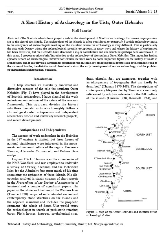
Hebrides (Fig. 1) have played in the development
of Scottish archaeology, I have classified the work
undertaken on the basis of the nature of the research
framework. This approach divides the history
into three thematic units which roughly follow a
chronological order: antiquarians and independent
researchers, rescue and university research projects,
and recent developments.
Antiquarians and Independents
The amount of work undertaken in the Hebrides
in the 19th century is limited, but three figures of
national significance were interested in the monuments
and material culture of the region: Frederick
Thomas, Alexander Carmichael, and Erskine Beveridge.
Captain F.W.L. Thomas was the commander of
the HMS Woodlark, and was employed to undertake
a survey of Orkney, Shetland, and the Hebridean
Isles for the Admiralty but spent much of his time
examining the antiquities of these islands. His discoveries
resulted in steady streams of short reports
in the Proceedings of the Society of Antiquaries of
Scotland and a couple of significant papers. His
paper on the stone architecture of the Western Isles
(Thomas 1870) compared and contrasted ancient and
contemporary stone structures on the islands and
the adjacent mainland and includes the prophetic
comment “the whole of South Uist would repay
the archaeologist in search of prehistoric remains;
barps, Pict’s houses, hypogea, mythological sites,
duns, chapels, &c., are numerous, together with
an idiosyncrasy of topography that can hardly be
described” (Thomas 1870:168). The descriptions of
contemporary life provided by Thomas are routinely
referenced by scholars interested in the folk culture
of the islands (Curwen 1938, Roussell 1934), and
A Short History of Archaeology in the Uists, Outer Hebrides
Niall Sharples*
Abstract - The Scottish islands have played a role in the development of Scottish archaeology that seems disproportionate
to the size of the islands. The archaeology of the islands is often considered to exemplify Scottish archaeology much
to the annoyance of archaeologists working on the mainland where the archaeology is very different. This is particularly
the case with Orkney where the archaeological record is exceptional in many ways and where the history of exploration
has been extensive, but the Hebrides have also made a major contribution and one which has perhaps been overlooked. In
this paper, I propose to give a brief introduction to the archaeology of the southern Outer Hebrides. The region has had an
episodic record of archaeological interventions which includes work by some important figures in the history of Scottish
archaeology and it has played a surprisingly significant role in some key archaeological debates and developments such as
the nature of brochs, the distribution of chambered cairns, the early development of rescue archaeology, and the problem
of unpublished archaeological backlogs.
Special Volume 9:1–15
2010 Hebridean Archaeology Forum
Journal of the North Atlantic
*School of History and Archaeology, Cardiff University, Cardiff, UK; Sharples@cardiff.ac.uk.
2015
Figure 1. Map of the Outer Hebrides and location of the
archaeological sites.
Journal of the North Atlantic
2
N. Sharples
2015 Special Volume 9
this is an important area for archaeological and
historiographical research that I will not be able
to explore here. This paper also records the unusually
well-preserved wheelhouse at Usinish on the
isolated west coast of South Uist, which is much
referenced but seldom visited (Hothersall and Tye
2000). He made a major contribution to Archaeologica
Scotica volume 7, which contains many of the
key early papers on brochs. This posthumous paper
(Thomas 1890) provided a detailed descriptive catalogue
of the Duns of the Outer Hebrides, which included
important folk tales associated with the sites.
The paper concludes with an excellent discussion of
the broch phenomenon, one that outlines the general
characteristics of these monuments and speculates
on issues such as roofing with a practical experience
that is unusual today.
Thomas was also in close contact with Alexander
Carmichael, the folklorist and Gaelic scholar who
lived on the Uists from 1864 to 1882 (Stiùbhart
2008), and he credits Carmichael for information on
the Uist duns in his 1890 paper (Thomas 1890:402).
Carmichael is most famous for his work on the oral
traditions of the islands, but he had a significant
reputation as an antiquarian and worked on a detailed
description of the antiquities of Uist, which
was never completed (Stiùbhart 2008). His discoveries
included the identification of several important
carved stones, which were relocated to the National
Museum of Antiquities of Scotland in Edinburgh
(Cheape 2008), most notably the important cross
slab with runic inscription in the graveyard of Cille
Bharra, Barra (Fisher 2001:107–108).
Erskine Beveridge, a wealthy industrialist who
inherited a linen mill in Dunfermline, is a more
important figure in the history of research in the
Uists. He made a significant contribution to the understanding
of not only the archaeology but the history,
folklore, and place-name studies of North Uist.
Beveridge came to the islands in 1897 after a period
of time exploring the islands of Coll and Tiree on the
Inner Hebrides (Beveridge 1903), and he purchased
the Vallay estate on the north coast of North Uist
in 1901. He built a substantial mansion on the tidal
island of Vallay, and this structure survives as an imposing
roofless ruin to this day. In the following two
decades, he excavated extensively across the estate,
poking holes in almost every archaeological monument
he could find. The work of the first decade was
published in a single volume North Uist (Beveridge
1911, reprinted 1999). The second decade was disrupted
by the First World War, but he returned to
excavation in 1918, only to die prematurely in 1920.
His later excavations were promptly written up by
Grahame Callander, the Director of the National
Museum of Antiquities of Scotland, which inherited
his archaeological collections and his draft reports
(Beveridge and Callander 1931, 1932).
Beveridge excavated at least 19 sites, including
extensive efforts at Bac Mhic Connain, Cnoc
a’Comhdhalach, Dun Thomaidh, Eilean Maleit,
Foshigarry, and Garry Iochdrach. The sites are
primarily documented by textual descriptions and
photographs, and though measured sketches exist
for many sites, detailed plans and records of the
stratigraphic relationships were not made. Artifact
collection was fairly thorough, and descriptions and
photographs were published of the important objects.
The published sketch plans suggest complex
phasing existed at most of the sites, and chronological
depth is indicated by the artifacts, but Beveridge
was unable to conceptualize this historical complexity,
and it is difficult to reconstruct without further
excavation. Unlike his contemporary, Pitt Rivers,
Beveridge appears uninterested in classification of
either the architecture or the finds. There was little
attempt to place the sites in a national or international
context, or to use the evidence to write a narrative
history of the occupation of North Uist.
The publication of these sites brought the archaeology
of North Uist to the attention of the research
community of Britain and Europe, and the evidence
produced by Beveridge was frequently drawn upon
by archaeologists writing general histories and
searching for comparanda. As a regional publication,
the volumes on North Uist (Beveridge 1911)
and Coll and Tiree (Beveridge 1903) were not to
be surpassed for some time. The discussion of the
chambered tombs was particularly important as
it identified two very different traditions of tomb
building on the island. These customs were later
characterized as the passage-grave and gallery-grave
traditions, and their contiguous presence was a
significant problem to both the interpretive frameworks
of Childe (1933) and Daniel (1941). The finds
assemblages recovered from excavations and deposited
in the National Museum were an important
resource that was widely known and referenced by
scholars interested in material culture throughout the
20th century. Hallén (1994) has recently re-analyzed
the worked-bone assemblages from Foshigarry and
Bac Mhic Connain and found much to say about the
material.
The first institutional work on the islands took
place during the early months of the First World War
when the Royal Commission for Ancient and Historical
Monuments of Scotland undertook a survey
of the monuments of the Outer Hebrides (RCAHMS
Journal of the North Atlantic
N. Sharples
2015 Special Volume 9
3
1928). This report was published in 1928 but is a
less-than-definitive catalogue of the ancient monuments
as it was undertaken in a very short period
of time when minds were concentrated on the forthcoming
war.
In the middle of the 20th century, research was
largely undertaken by a disparate group of individuals—
Sir Lindsay Scott, Thomas Lethbridge, Alison
Young, Audrey Henshall, and Iain Crawford—who
had connections with the developing profession of
archaeology but were also slightly removed from it.
Most of these people had access to a private income
and were therefore relatively free to research where
they wanted and to interpret as they wanted.
Sir Lindsay Scott is probably the most established
and conventional archaeologist of this group. He was
a senior civil servant all his working life. During the
Second World War he was second secretary in the
Ministry of Aircraft Production under Lord Beaverbrook
and responsible for meeting critical aircraft
production targets during the Battle of Britain (The
Times obituary June 1952). He retired immediately
after the war and become President of the Prehistoric
Society (1946–1950) before his untimely death in
1952. He seems to have been drawn to work on the islands
because of his love for sailing, and it appears his
yacht provided the base for his excavation projects.
His first recorded work was on the Outer Hebrides
in the 1920s, but his first significant project was at
Rudh an Dunain, an exceptionally well-preserved
chambered tomb on the remote west coast of Skye
(Scott 1932). He moved to the Outer Hebrides to
work on the chambered tombs at Clettraval in 1934
(Scott 1935) and Unival in 1935 (Scott 1947b), both
of which are located on the edge of major hills on the
west side of North Uist. The excavation of the Neolithic
culminated in the 1938 excavation of the island
settlement at Eilean an Tighe (Scott 1950). His work
on the chambered tomb at Clettraval led to the unexpected
discovery of a well-preserved wheelhouse
inserted into the body of the cairn. After the war,
his work focused on the Iron Age settlement of the
islands. His final excavation was the wheelhouse at
Tigh Talamhanta, Allasdale, on Barra (Young 1952).
The Neolithic settlement at Eilean an Tighe (Scott
1950) was one of the first Neolithic settlements excavated
in Britain that showed any above-ground structural
evidence. The excavations produced roughly
4500 sherds of pottery and uncovered the remains of a
series of structural features that included hearths and
what Scott interpreted as ovens. Unfortunately these
elements proved very difficult to interpret in terms
of site function and significance, a characteristic
that is common to all later Neolithic settlements on
the islands, and Scott argued that the site was a pottery
production center with furnaces used to fire the
pots, an interpretation that was only finally rejected
in the 1970s (Simpson 1976). Despite this misleading
interpretation, Eilean an Tighe was one of only a
handful of Neolithic settlements identified in Britain
prior to the 1970s, and it was routinely referenced in
discussions of early settlement (e.g., McInnes 1971).
Scott used the evidence of the pottery and the unusual
chambered tombs to argue for a strong regionally
distinctive Neolithic culture that was well connected
to communication routes along the seaboard of Scotland
(Scott 1942, 1951), and this idea was taken up by
Piggott (1954) in his influential synthesis Neolithic
Cultures of the British Isles.
Scott published two substantial papers on Later
Prehistory in the Proceedings of the Prehistoric Society:
the first was titled the Problem of the Brochs
(Scott 1947a) and the second examined wheelhous -
es (Scott 1948). If these papers had been combined,
they would have made an impressive book-length
study of the Atlantic Iron Age. The paper on brochs
triggered widespread debate and raised problems
that are still of considerable significance today.
Scott argued for the essentially domestic nature of
the broch, suggesting that these structures should
be considered as elaborate houses comparable to
other circular British houses. This hypothesis assumed
a widespread distribution of relatively lowwalled
structures which challenged the elite “castle
complex” interpretation of Childe (1935:197–206).
There was an immediate response by Angus Graham
(1947) who legitimately challenged some of
the interpretations, but the idea of an overwhelmingly
domestic function for brochs remains central
to current interpretation today. Many of the issues
that dominate recent debates (Armit 1990, 1992a,
Barrett and Foster 1991, Parker Pearson et al 1996,
Sharples 2003, 2006, Sharples and Parker Pearson
1997) were originally fleshed out in this paper;
for example, the question of whether brochs represent
just one aspect of the settlement pattern or
provide the only settlements in the Middle Iron
Age is still disputed (compare Sharples 2005a with
Armit 1997). By publishing his principal papers
on later prehistory (Scott 1947a, 1948) in the Proceedings
of the Prehistoric Society, Scott was also
placing the Hebridean Iron Age in a wider national
and international context. Unfortunately, much of
Scott’s argument was placed within a diffusionist
framework that was then becoming oppressively
dominant in British archaeology, and this context
undermines the wider validity of his analysis for
most modern archaeologists.
Journal of the North Atlantic
4
N. Sharples
2015 Special Volume 9
Scott was an excellent field archaeologist, and
his work is of considerable importance simply as
the first detailed field record of several important
monument types, including wheelhouses and chambered
tombs. His excavations were meticulous, and
MacKie (2007:1146) claims he “brought modern
scientific excavations to the Iron Age sites of Atlantic
Scotland” . The analysis of the substantial
ceramic assemblages recovered by his excavations
was comprehensive, with detailed classifications
of decoration, vessel form, rim, and base shapes all
quantified in large tables and statistically analyzed
(Scott 1948:117–120, table 1). While this approach
is now thought to be simplistic, it did provide an
essential building block that enabled the establishment
of the Hebridean ceramic sequence by Alison
Young (1966). A sequence that is still relevant today
(Campbell 2002).
It was unfortunate that he died while still active
in the field. His excavations at the Neolithic settlement
of Eilean an Tighe were brought to publication
by his son (Scott 1950), and the excavations at Tigh
Talamhanta, Allasdale, Barra, were completed by
Alison Young (1952), who had been working as his
assistant. This site was another upland wheelhouse,
directly comparable to Clettraval, with free-standing
stone walls that were penetrated by a souterrain,
similar to that at Usinish. Young continued to work
on the islands in the 1950s, and she excavated two
key sites: the wheelhouse at A’Cheardach Mhor
(Young and Richardson 1960), which will be discussed
later, and Dun Cuier (Young 1956).
The excavations at Dun Cuier have been the
subject of some debate in recent years. The principal
monument is a thick-walled, roughly circular
structure that has been interpreted as a broch (Armit
1988), but which has some architectural peculiarities
that challenge this identification (MacKie
2007:1108). These features include an unusual entrance,
the absence of an intra-mural staircase, and
the absence of any access between the wall chamber/
gallery and the interior. Dun Cuier does, however,
have a scarcement, which suggests the wall was high
enough to support an upper floor. The most important
findings of the excavations were the recovery of
a large assemblage of ceramics and a distinctive assemblage
of worked-bone objects, including parallelepiped
bone die and composite bone combs—the
latter clearly providing a date in the second half of
the first millennium AD. The site therefore provided
evidence for the nature of Late Iron Age ceramics,
and the material formed an important element in
the Hebridean ceramic sequence outlined by Young
(1966; see below). The early part of the Dun Cuier
assemblage is very similar to the assemblage recovered
from mound 1 at Bornais, which can now be accurately
dated to the 5th century AD (Sharples 2012).
Only a minimal amount of elaborately decorated
Middle Iron Age ceramics were recovered, which
suggests that this complex dry-stone structure was
constructed in the 5th, or possibly 4th, century AD at
its earliest.
Tom Lethbridge was the keeper of Anglo Saxon
Antiquities in the University Museum of Archaeology
and of Ethnology, Cambridge. He was also
attracted to the islands because of an interest in
sailing and published several books on sailing in
the North Atlantic that incorporated archaeology
and tried to interpret it from a distinctive maritime
perspective (Lethbridge 1950). Lethbridge’s career
was characterized by a rather personal approach to
archaeological interpretation, and his ideas became
more and more idiosyncratic in the late 1950s and
1960s. He resigned his position at the Museum
and became increasingly obsessed with hidden
forces, which he could identify by dowsing. He
developed a complicated methodology that enabled
him to read the past and to predict sites by dowsing
maps. The most dramatic result of this work was
the “discovery” of distinctive chalk figures on the
Gog Magog Hills just south of Cambridge. This
late flowering of creativity has made Lethbridge a
heroic figure in the alternative community but has
tended to undermine his reputation as an archaeologist
(Welbourn 2011).
Lethbridge was invited to undertake the excavation
of a wheelhouse in South Uist by another
idiosyncratic character, the German anthropologist,
photographer, and filmmaker Werner Kissling (Russell
1997, 2002). The purpose was to open up one
of the mounds on the machair and reveal a wheelhouse
that could be used to inform the locals about
their archaeological past and provide an attraction
that visitors to the island could view. After a brief
survey of the south end of the island, the mound
known as the Bruthach a’Sithean (Brae of the Fairy
Hill) was chosen in the township of Cille Pheadair
(Kilpheder). Excavations revealed a spectacularly
well-preserved wheelhouse that had stone walls
over 2.25 m high (Lethbridge 1952). There was clear
evidence that these walls supported corbelled vaults
around the central circular space that Lethbridge
took to be unroofed, but which most archaeologists
would now accept as having had a timber roof. The
excavation was promptly published and provided the
first well-excavated example of a wheelhouse on the
machair that could be compared with the moorland
wheelhouses of Clettraval and Tigh Talamhanta.
Journal of the North Atlantic
N. Sharples
2015 Special Volume 9
5
Audrey Henshall visited the Uists in 1962 as
part of her survey of the chambered tombs of Scotland,
and the findings were published in Volume 2
(Henshall 1972). Her work emphasized the regional
characteristics of the Scottish tombs and situated
the Hebridean passage tombs within the Orkney,
Cromarty, Hebridean group of northern Scotland.
The presence of tombs derived from the Clyde tradition
was acknowledged, and this finding was argued
to indicate the widespread contacts of the region
located on the western sea routes. The presence of
Henshall's detailed corpus of tombs meant that the
evidence from the Western Isles could be incorporated
into wider discussions of the chambered-tomb
phenomenon (Müller 1988), and the concentration
of tombs on North Uist has been a feature for repeated
speculative interpretation ever since (Armit
1996:94, Kinnes 1985:33, Sharples 1992:327).
Iain Crawford was a freelance archaeologist who
started out with ties to the University of Cambridge.
He specifically set out to identify and explore an
unfortified and indigenous settlement sequence that
spanned the period from the Iron Age through to the
post-medieval period in the west Highlands (Crawford
and Switsur 1977:124–125). His research led
him to Coileagan an Udail, a settlement complex
at the end of a peninsula extending from the north
coast of North Uist. This area benefited from having
been explored but not systematically excavated by
Beveridge, and the local estate papers were extensive
and available for analysis. The site comprised
two substantial tell-like settlement mounds as well
as several smaller settlements in adjacent areas close
to the coastline. The archaeological sequence turned
out to be even more spectacular than was expected.
The coastal sites produced important evidence for
Neolithic and Early Bronze Age settlement, and the
two larger mounds provided what was argued to be a
continuous sequence of settlement from the Middle
Iron Age (though earlier deposits are suspected on
the south mound) through to the end of the 17th century
(Crawford and Switsur 1977).
The excavations at the Udal recovered well-stratified
assemblages of ceramic, worked-bone, stone,
and metal artifacts that provide key evidence for the
chronological succession and cultural contacts of
island societies. A very large bone assemblage and
the systematic recovery of carbonized plant remains
provide key evidence for the agricultural economy
and how it changed over time. The extensive area
of excavations and the presence of well-preserved
buildings provided the opportunity to explore settlement
patterning as opposed to individual structural
detail. No previous excavation had been undertaken
on such a scale or with such attention to detail, and
the potential of this project was immense. However,
the size and the complexity of the archaeological
record created an impossible administrative problem.
The excavation was a research project that was
never well funded; the only state funding was tied
to the rescue excavation of the Late Neolithic and
Beaker settlement on the shoreline. As a result of the
limited funding, no substantive publication has been
made and researchers are reliant on a small number
of short-interim publications and discussion papers
(Crawford 1974a, 1981, 1986, 2002; Crawford and
Switsur 1977; Selkirk 1996). These reports provide
little more than tantalizing glimpses of the archaeological
record and do not really allow for any substantive
use of the material. The situation was made
worse by the belligerent character of the excavator
who restricted access to the material recovered by
his excavations1 and who in his later years actively
discouraged archaeologists from working on the
islands.2
Rescue and University Research Programs
The amount of pure rescue work in the Uists
has been surprisingly little given the fragility of the
environment and the prevalence of the archaeology.
The coastal plain, which was the main focus for
settlement activity for millennia, is under constant
threat of erosion by the sea and the wind, which has
led to the destruction of large numbers of monuments,
and in some areas complete landscapes appear
to have disappeared in the recent past. Both
the coastal sand dunes and the peat deposits of the
interior are significant resources for the local community
and are routinely removed for a variety of
purposes. Development may seem to be less of a
threat than in the industrial heartlands of Scotland,
but as we will see it does exist and plays a significant
role in the discovery of archaeological remains.
Strangely, this part of the history begins not
with the problem of coastal erosion but instead
with the Ministry of Defence decision to build a
Rocket Range on the island of South Uist in 1955.
This decision led to one of the earliest and most important
rescue archaeology projects undertaken in
Scotland—a pioneering attempt to undertake extensive
excavations in advance of a major construction
project. A team of experienced archaeologists—Horace
Fairhurst, Richard Feachem, Allard Johnson,
Alastair MacLaren, Kitty Richardson, Jack Scott,
James Wallace, and Alison Young—was recruited for
a summer season in 1956. The work continued into
1957, when Richard Atkinson was added to the team,
Journal of the North Atlantic
6
N. Sharples
2015 Special Volume 9
A successful end to the project might have
stimulated the Ministry of Works to support further
rescue excavations in the region. In the late
1970s, there was considerable pressure to undertake
rescue excavation in advance of coastal erosion
and the Hebrides featured in one of the most
important polemical publications ever produced
by archaeologists—Rescue Archaeology (Rahtz
1974). Ian Crawford provided, as a case study, a
detailed description of the destruction of the Red
Smiddy at Baleshare, which documented not only
its relentless erosion by the sea but an extreme form
of casual vandalism using a mechanical excavator
(Crawford 1974b, Fairhurst and Ritchie 1963).
Unfortunately, though the site was known to be a
problem for decades, no substantial archaeological
excavations were undertaken until 1984 when only
the vestigial remnants of the site survived. It was
completely obliterated in the 2005 storm, which
exposed a new site that is now being examined (see
Dawson 2015 [this volume]).
There is a compelling case that there should have
been more substantial excavations in the 1960s,
1970s, and 1980s, but the response by Historic Scotland
was limited. The National Museum of Antiquities
of Scotland sponsored a salvage excavation of
a corbelled cist at Rosinish on Benbecula in 1964
(Crawford 1977). This effort resulted in the identification
of an important beaker settlement that was
eventually excavated by Ian and Leckie Shepherd
(Shepherd 1976, Shepherd and Tuckwell 1977) in
1974, 1976, and 1977. The settlement comprised
a “structure” surrounded by a heavily manured
infield containing large quantities of ceramics and
evidence for the cultivation of barley. Underlying
the ploughsoil were distinctive marks that indicated
the field had been cultivated by simple ards. The site
was of considerable importance in demonstrating
how widespread and important cereal cultivation
was in the Beaker period (Burgess 1980:219). As a
response to the pressures of Crawford and others, a
systematic coastal erosion survey was undertaken
by Ian and Leckie Shepherd in 1978. This work
complemented a survey of Lewis and Harris undertaken
by Trevor Cowie of the Central Excavation
Unit (unpubl. data).
These surveys provided a detailed list of sites in
the coastal zone which prioritized the level of threat
and the sites which seemed most at risk, but they
were not acted upon until 1983 when a further survey
was undertaken by the Central Excavation Unit.
This effort led to the excavation of five sites in 1984
(Barber 2003). However, the approach was limited
to “tapestry excavation”, which involved cutting
but it was abruptly terminated due to Ministry of Defence
budget cuts which forced a significant redesign
of the original plans. The principal buildings in the
new plans completely avoided most of the excavated
sites and it turned out that only the wheelhouse, Bruathach
a’Tuath, would be destroyed due to an extension
to the runway of the airport at Benbecula.
The project resulted in the excavation of several
important wheelhouse settlements: A’Cheardach
Bheag (Fairhurst 1971) and A’Cheardach Mhor
(Young and Richardson 1960) on South Uist, Machair
Leathann, Sollas (Campbell 1991) on North Uist,
and Bruathach a’Tuath on Benbecula. The project
also exposed the first Viking house to be identified
on the islands, at Drimore, on South Uist (MacLaren
1974). The accompanying survey undertaken by Roy
Ritchie also located a variety of settlement mounds
that were explored during later machair surveys
(Parker Pearson 2012a, b), which included the presence
of an important Beaker settlement.
The original intention had been to publish the
excavations in a single volume for the Ministry of
Works Archaeological Reports Series, which had
recently been started with the Jarlshof report (Hamilton
1956). The volume was to be edited by Stuart
Piggott, and would include reports on all the sites
and an introductory chapter by Roy Ritchie on the
survey that preceded the excavations. However, it
almost immediately proved to be impossible to coordinate
the production of this volume, and it was
critically undermined by the decision to publish the
excavation of A’Cheardach Mhor as an article in
Proceedings of the Society of Antiquaries of Scotland
(Young and Richardson 1960).
The submission of this report caused a heated
debate in the Society of Antiquaries publications
committee and an attempt was made to block the
publication of the paper because the consequences
for the integrity of the volume were clear. Piggott
favored publication of A’Cheardach Mhor in the Proceedings,
and as there was no sign of the immanent
delivery of the other papers, the Ministry decided
that it would be unfair to delay publication. The
impetus for the volume collapsed and it was over a
decade before any other reports appeared (Fairhurst
1971, MacLaren 1974) and another two decades before
the excavations at Sollas were published (Campbell
1991), and some sites remain unpublished. If the
monograph had been published in the 1960s, it would
have made a major contribution to the understanding
of the Iron Age in Britain. The excavations had assembled
a substantial body of information about domestic
architecture and material culture that would
have been the envy of many regions.
Journal of the North Atlantic
N. Sharples
2015 Special Volume 9
7
The Edinburgh program was largely based in
Lewis (Armit 2006, Harding and Armit 1990, Harding
and Dixon 2000, Harding and Gilmour 2000)
and so is not the principal focus of attention for
this paper; nevertheless, it is important to note the
work undertaken by Ian Armit and his colleagues in
North Uist. They undertook small-scale excavations
at the chambered tomb of Geirisclett (Dunwell et
al. 2003), the burnt mound at Ceann nan Clachan
(Armit and Braby 2002), the wheelhouse at Eilean
Maleit (Armit 1998), and Iron Age houses at Eilean
Olabhat (Armit et al. 2008), all of which have provided
useful evidence and important radiocarbon
dates. The most-sustained and important piece
of work in the region was at the Neolithic settlement
of Eilean Domhnuill (Armit 1992b). This is a
settlement of considerable importance to the understanding
of the early prehistoric occupation of the
Western Isles (Armit and Finlayson 1992). The site
contains a stratified sequence of structural remains
and paired rectangular buildings, surrounded by
deposits rich with pottery (over 22,000 sherds) and
stone tools, including decorated stone balls (Armit
1992b). The site is an island location, similar to Eilean
an Tighe, joined to the mainland by a causeway.
However, unlike Eilean an Tighe, the occupation
levels have been repeatedly inundated due to a rising
water table, which has resulted in the preservation
of a substantial assemblage of organic materials.
The rise in the water levels of the loch might explain
the repeated presence of distinct chronologically
separate occupation horizons and suggests the site
might have been seasonally occupied (Armit 1996).
The quality of the preservation makes this one of the
most important Neolithic settlements in Britain.
The SEARCH project began in 1988 and originated
as a direct follow up to the Central Excavation Unit
project of 1983–1984 (Branigan 2007, Sharples et al.
2004). A large portion of the post-excavation analysis
that followed the CEU projects was done in the
University of Sheffield, and this effort stimulated the
development of a “major long-term program of integrated
environmental and archaeological research in
a marginal landscape” (Branigan and Foster 2000:1).
This program was instigated by Richard Hodges and
Dave Gilbertson and was intended to take most of the
staff and students of the department at Sheffield to
the Hebrides for a summer fieldwork season. Richard
Hodges left the project to become Director of the
British School in Rome before any meaningful fieldwork
was underway, and leadership was passed to the
Head of Department, Keith Branigan.
The first field season was in 1988 when Branigan
and Foster began a survey of Barra. Work soon
back, cleaning, and recording the coastal exposures.
This procedure was accompanied by systematic coring
that defined the inland extent of the settlements.
The most significant excavation was Hornish Point
at the north end of South Uist (James and McCullagh
in Barber 2003). This is a large settlement mound
with the remains of a wheelhouse and several other
structures exposed in the coastal section. A large part
of the mound still survives, and the site has the potential
to make a very important contribution to our
understanding of later prehistory. The most intriguing
find from the site was the dismembered remains
of a young child carefully placed in a pit below the
floor of the wheelhouse (Barber et al. 1989).
The approach taken was rigorously scientific
with the hypothetico-deductive method applied to
the post-excavation process (Barber 2003:114).
Economic and environmental evidence were very
thoroughly examined and new techniques were explored,
including phytolith and diatom analyses. The
mollusc analysis was used to interpret site taphonomy
rather than environmental history.3 Unfortunately,
the impact of the work was diminished by the
limited nature of the archaeological interventions.
The tapestry excavation did not provide enough material
to fully understand what were clearly complex
settlements, and the fragmentary elements of most of
the structures defied easy interpretation. The assemblages
of animal bones and carbonized plant remains
provided information that by the time of publication
(2003) was better documented on other sites,
but again the excavations produced relatively small
assemblages which restricted interpretation. The
chronology of the sites was problematic due to the
use of marine shell for most of the radiocarbon dates.
The results have been used to argue for misleadingly
early dates for wheelhouses and elaborately decorated
ceramics (Armit 1991).
These exploratory excavations by the Central
Excavation Unit were intended to be followed up
with the full-scale excavation of one of the selected
sites, but financial pressures prevented it from taking
place. In the final decade of the 20th century, the
responsibility for the monitoring of the rescue threat
effectively passed to university-based researchers
who, through the use of student labor, could
deliver large-scale excavations at a relatively economic
cost.4 From the late 1980s through to the early
2000s, the Western Isles were the focus of major
research programs by two different teams: one from
Edinburgh University worked in North Uist, Harris
and Lewis, and a second team, from the Universities
of Sheffield and Cardiff, worked in South Uist,
Barra, and the southern isles5.
Journal of the North Atlantic
8
N. Sharples
2015 Special Volume 9
became focused on Ben Tangaval in the southeast
corner of the island because the archaeology here
was threatened by the construction of a road providing
access to the causeway to Vatersay (Branigan and
Foster 1995). The immediate threat was to a recent
farmstead at Alt Chrisal, but it was soon realized
that this was built on top of an important Neolithic
and Beaker settlement. The excavations produced a
substantial assemblage of ceramics comparable to
those from Eilean an Tighe and Eilean Domhnuill,
and the structural evidence from the main site was
characteristically difficult to interpret. A second field
team, including Andrew Fleming, John Moreland,
and Marek Zvelebil, was dispatched to South Uist.
Moreland and Fleming undertook a walk-over survey
of the blacklands in the center of the island (Fleming
2011, Moreland 2011). Zvelebil began the excavation
of a small wheelhouse on the machair at Cill Donnain
that was suffering badly from wind erosion (Parker-
Pearson and Zvelebil 2014, Zvelebil 1991).
Running parallel with the archaeological work on
Barra and South Uist were a series of environmental
projects. These efforts were coordinated by Gilbertson
and focused on an examination of the character
and history of the machair environment (Edwards
et al. 2005, Gilbertson et al. 1996, 1999; Kent et al.
1996, Powers et al. 1989) and the environmental history
of the peatlands (Brayshay and Edwards 1996,
Weaver et al. 1996). Other projects included an analysis
of the site-formation processes of a recently abandoned
Hebridean croft (Smith 1996, 2011), which
was intended as a model for site-formation processes
that could be applied to ancient settlements.
The project was initially set up to run for five
years, but Branigan and Foster continued their exploration
of Barra and the islands to the south until
2000. Small -scale excavations were undertaken on
a number of settlements (Branigan and Foster 1995,
2000). Foster concentrated on badly damaged and
eroding prehistoric settlements, including a wheelhouse
adjacent to the early prehistoric settlements at
Alt Chrisal on Barra, a badly eroded broch at Dunan
Ruadh, an unusual cellular structure at Bàgh Bàn
on the island of Pabbay, and middens at Sheadar
on Sanday and Chapel House on Mingulay. Branigan
initially concentrated on upland sites which
included a couple of kerb cairns on Vatersay and
the trial trenching of an enclosure and a hut circle
in the Borve valley and Scurrival Cave on Barra.
The results were variable, but some sites produced
important assemblages of animal bone which are
categorically different from the assemblages from
the main islands. Dating is unfortunately problematic
for several sites as very few radiocarbon dates
were acquired, and though pottery assemblages
were relatively common, they only provide rough
chronologies. Nevertheless, the material recovered
suggests Early Iron Age sites exist, notably the small
hut circle in the Borve valley.
Barra and the southern islands were completely
surveyed resulting in the identification of a large
numbers of archaeological monuments (Branigan
and Foster 2000). These structures included new examples
of monuments already known on the islands,
including wheelhouses, chambered tombs, and an
unfinished broch, but perhaps of greater import
were the identification and mapping of a wide range
of previously unknown types of monuments. The
identification of these new types of sites provided
a much broader understanding of the Hebridean
landscape and demonstrated the extensive nature of
settlement evidence. It became clear that the picture
of an Iron Age landscape where settlement was restricted
to a small number of isolated monumental
structures (Armit 1992a, 2005a, 2005b) was misleading.
Instead we have to envisage a much more
densely occupied landscape filled with many varied
and different forms of settlement. In the last years of
the project, Branigan focused his attentions on the
pre-clearance settlements and has made a major contribution
to the understanding of the post-medieval
archaeology of the Western Isles (Branigan 2005).
On South Uist, developments took a different
course (Sharples et al. 2004). Mike Parker Pearson
joined Sheffield University in 1990. He was enthusiastic
about becoming involved in the work on
South Uist and encouraged the participation of the
author. We were interested in excavating sites on the
machair as doing so seemed to be the only way to
chart the chronological developments of the material
culture, architecture, and economy. The organization
of the Udal project was very influential on our efforts
and though the specific objective—to provide
a long-term archaeological narrative for settlement
that spanned prehistory up to the Clearances—was
very similar, the approach taken was quite different.
We identified a variety of problems in the path taken
by Crawford that had ultimately led to the nonpublication
of the results and these encouraged us to
develop a number of principles:
• To excavate at least a couple of sites from
each period and not to become focused on a
single exceptional site.
• To make no attempt to completely excavate
these sites but to restrict our exploration to
an area sufficient to provide an accurate and
well-understood picture of the settlement and
to recover enough material to enable detailed
environmental and economic analysis.
Journal of the North Atlantic
N. Sharples
2015 Special Volume 9
9
Locally Based Rescue Archaeology
In recent years, the period of large university
training programs seems to have come to an end.
This shift is largely a result of the more limited role
played by Historic Scotland in rescue excavation
given the move to a polluter-pays approach to the
funding of rescue archaeology. Developer-funded
excavation excludes most university researchers
in favor of commercial enterprises. These units
have begun to make regular visits to the islands
to undertake excavations related to the construction
of causeways to Eriskay and Berneray and the
upgrade of the main road through the islands. The
latter projects have resulted in the discovery of two
important Neolithic settlements at Rubh a’Charnain
Mhor (Downes and Badcock 1998) and Barpa Langais
(Holderness 2007), in the peatlands. These
developments have also led to the establishment
of a commercial archaeological unit on the islands.
Uistarchaeology, as the enterprise is called, provides
a range of archaeological services to the local
community and external developers.
The introduction of developer-funded archaeology
and the limited fieldwork budgets available to
Historic Scotland mean that natural threats, such as
coastal erosion, are difficult to deal with (Wessex
Archaeology 2008). State funding is increasingly
difficult to obtain on the scale required to excavate
the large complex sites, such as Dun Vulan, that are
threatened by potentially devastating erosion (Parker
Pearson et al. 2011). An alternative approach has
been the creation of a charity, SCAPE, that seeks to
research, conserve, and promote the archaeology of
Scotland's coast. It publicizes and coordinates the
successful Shorewatch scheme that encourages local
communities to record and excavate threatened sites.
Access Archaeology is a group on North Uist who
have been excavating the wheelhouse at Sloc Sabhaidh,
Baile Sear, as part of the Shorewatch project
(Rennell and McHardy 2009).
University involvement in the archaeology of the
islands has not been completely excluded by these
developments. In 2012, Southampton and Liverpool
Universities excavated an important Neolithic settlement
at An Doirlinn, South Uist, which was in danger
of being completely destroyed by the sea (Garrow
and Sturt 2013). This site was excavated as part
of the AHRC-funded Steppingstones project that is
designed to explore the arrival of the Neolithic along
the western seaboard of Britain. Birmingham University
have also undertaken survey and excavations
on the adjacent island of Harris (Colls and Hunter
2010).
• To involve other archaeologists who took
responsibility for their sites and their materials
and were not under our control.
• To try to publish as much as possible as
quickly as possible; individual sites were
published serially, and at Bornais the rationale
behind the publication strategy is to
make the information available as quickly as
possible.
• Most importantly we made every effort to
acquire support from Historic Scotland for
the major excavations on threatened sites.
This commitment has tied them into providing
financial support for post-excavation
analyses and publication, which would have
otherwise been difficult to acquire.
Since 1990, we have excavated a large number
of sites that provide an exceptionally broad coverage
of the island’s archaeology, from the Neolithic to the
19th century (see below). The most-significant excavations
are the broch at Dun Vulan (Parker Pearson
and Sharples 1999), the Iron Age to Norse sequence
at Bornais (Sharples 2005b, 2011; Sharples and
Smith 2009; Sharples et al., in press), the Norse
settlement at Cille Pheadair (Brennand et al. 1998;
Parker Pearson et al. 2004b), the post-medieval
settlement at Airigh Mhuillin (Symonds 1997), and
the Late Bronze Age settlement at Cladh Hallan
(Parker-Pearson and Zvelebil 2014; Parker Pearson
et al. 2000, 2005). These excavations have proved
remarkably interesting and productive. Indeed, the
amount of material recovered has proved logistically
difficult, and our publications have been less
frequent than we would have liked. There have also
been a number of small-scale excavations that examined
chambered tombs (Cummings 2011), beaker
settlements (Hamilton and Sharples 2011, Sharples
1998a, 2009, 2011), and many post-medieval structures
(Raven 2011b).
The machair plain was systematically surveyed,
and over 241 settlement mounds were identified
(Parker Pearson 2012a:12). A survey of the
chambered tombs of South Uist considered their
location and provided a phenomenological interpretation
as well as detailed descriptions of the
surviving remains (Cummings et al. 2005, 2011).
Several PhDs were completed through the course
of the project including a detailed consideration
of the Neolithic settlement (Henley 2005, 2011)
and the Medieval occupation (Raven 2005, 2011b)
of the Uists. The last field season for the project
was in 2004 when the excavations at Bornais were
completed.
Journal of the North Atlantic
10
N. Sharples
2015 Special Volume 9
Armit, I. 1998. Re-excavation of an Iron Age wheelhouse
and earlier structure at Eilean Maleit, North Uist.
Proceedings of the Society of Antiquaries of Scotland
128:255–271.
Armit, I. 2005a. The Atlantic roundhouse: A beginner’s
guide. Pp. 5–10, In V. Turner, R.A. Nicholson, S.J.
Dockrill, and J.M. Bond (Eds.). Tall Stories? 2 Millennia
of Brochs. Shetland Amenity Trust, Lerwick, UK.
Armit, I. 2005b. Land-holding and inheritance in the
Atlantic Scottish Iron Age. Pp. 129–143, In V. Turner,
R.A. Nicholson, S.J. Dockrill, and J.M. Bond (Eds.).
Tall Stories? 2 Millennia of Brochs. Shetland Amenity
Trust, Lerwick, UK.
Armit, I. 2006. Anatomy of an Iron Age Roundhouse:
The Cnip Wheelhouse Excavations, Lewis. Society of
Antiquaries of Scotland, Edinburgh, UK.
Armit, I., and A.R. Braby. 2002. Excavation of a burnt
mound and associated structures at Ceann non
Clachan, North Uist. Proceedings of the Society of
Antiquaries of Scotland 132:299–358.
Armit, I., and B. Finlayson. 1992. Hunter-gatherers transformed:
The transition to agriculture in northern and
western Europe. Antiquity 66:664–676.
Armit, I., E. Campbell, and A. Dunwell. 2008. Excavation
of an Iron Age, early historic, and medieval settlement
and metalworking site at Eilean Olabhat, North Uist.
Proceedings of the Society of Antiquaries of Scotland
138:27–104.
Barber, J. 2003. Bronze Age Farms and Iron Age Farm
Mounds of the Outer Hebrides. Society of Antiquaires
of Scotland (Scottish Archaeological Internet Reports
3), Edinburgh, UK. Available online at http://www.
sair.org.uk. Accessed September 2008.
Barber, J., P. Halstead, H. James, and F. Lee. 1989. An
unusual Iron Age burial at Hornish Point, South Uist.
Antiquity 63:773–778.
Barrett, J.C., and S.M. Foster. 1991. Passing the time in
Iron Age Scotland. Pp. 44–56, In W.S. Hanson and
E.A. Slater (Eds.). Scottish Archaeology: New Perceptions.
Aberdeen University Press, Aberdeen, UK.
Beveridge, E. 1903. Coll and Tiree. T & A Constable,
Edinburgh, UK.
Beveridge, E. 1911. North Uist: Its Archaeology and Topography.
William Brown & Co, Edinburgh, UK.
Beveridge, E., and J.G. Callander. 1931. Excavation of an
earth house at Foshigarry and a fort, Dun Thomaidh, in
North Uist. Proceedings of the Society of Antiquaries
of Scotland 65:299–357.
Beveridge, E., and J.G. Callander. 1932. Earth houses at
Garry Iochdrach and Bac Mhic Connain in North Uist.
Proceedings of the Society of Antiquaries of Scotland
66:32–67.
Branigan, K. 2005. From Clan to Clearance: History and
Archaeology on the Isle of Barra c. 850–1850 AD.
Oxbow Books, Oxford, UK.
Branigan, K. 2007. Ancient Barra: Exploring the Archaeology
of the Outer Hebrides. Comhairle nan Eilean
Siar, Stornoway, UK.
Branigan, K., and P. Foster. 1995. Barra: Archaeological
Research on Ben Tangaval. Sheffield Academic Press,
Sheffield, UK.
Conclusion
The 20th century was a period when the archaeology
of the islands was controlled by outsiders, initially
a group of rich idiosyncratic amateurs and more recently
groups of university-trained academics. These
have imposed their own views of the archaeological
history of the islands and have dictated the nature
and medium of the debate (the English language).
It is clear that circumstances are changing and that
archaeology is becoming a more devolved process.
Archaeological contractors have become settled on
the islands, and the archaeological work is being
driven, as it is throughout Britain, by development.
There is a regional archaeologist, a post established in
1998, who controls the development process, and local
communities are much more involved in the work
undertaken. These groups want the recovered material
to be displayed in local museums and the sites
presented to the public. Cultural tourism will become
increasingly important and has already resulted in
the public presentation of many sites and the creation
of a series of locally published guidebooks to the archaeology
of the islands (e.g., Branigan 2007; Parker
Pearson et al. 2004a, 2008). The 21st century will provide
a whole new set of problems and opportunities,
and the archaeology of the Western Isles should continue
to provide an important resource for a range of
interest groups that includes the local communities as
well as the wider community of academics throughout
Europe and North America who find this region
immensely interesting.
Literature Cited
Armit, I. 1988. Broch landscapes in the Western Isles.
Scottish Archaeological Review 5:78–86.
Armit, I. (Ed.). 1990. Beyond the Brochs: Changing Perspectives
on the Later Iron Age in Atlantic Scotland.
Edinburgh University Press, Edinburgh, UK.
Armit, I. 1991. The Atlantic Iron Age: Five levels of chronology.
Proceedings of the Society of Antiquaries of
Scotland 121:181–214.
Armit, I. 1992a. The Later Prehistory of the Western Isles
of Scotland. British Archaeological Reports (British
Series, 221), Oxford, UK.
Armit, I. 1992b. The Hebridean Neolithic. Pp. 307–321,
In N.M. Sharples and A. Sheridan (Eds.). Vessels for
the Ancestors: Essays on the Neolithic of Britain and
Ireland. Edinburgh University Press, Edinburgh, UK.
Armit, I. 1996. The Archaeology of Skye and the Western
Isles. Edinburgh University Press, Edinburgh, UK.
Armit, I. 1997. Cultural landscapes and identities: A case
study in the Scottish Iron Age. Pp. 248–253, In A.
Gwilt and C. Haselgrove (Eds.). Reconstructing Iron
Age Societies. Oxbow Books, Oxford, UK.
Journal of the North Atlantic
N. Sharples
2015 Special Volume 9
11
Branigan, K., and P. Foster. 2000. From Barra to Berneray:
Archaeological Survey and Excavation in the
Southern Isles of the Outer Hebrides. Sheffield Academic
Press, Sheffield, UK.
Branigan, K., and P. Foster. 2002. Barra and the Bishop’s
Isles: Living on the Margin. Tempus, Stroud, UK.
Brayshay, B.A., and K.J. Edwards. 1996. Late-glacial and
Holocene vegetational history of South Uist and Barra.
Pp. 13–26, In D. Gilbertson, M. Kent, and J. Grattan
(Eds.). The Outer Hebrides: The Last 14,000 Years.
Sheffield Academic Press, Sheffield, UK.
Brennand, M., M. Parker Pearson, and H. Smith. 1998.
The Norse settlement and Pictish cairn at Kilphedir,
South Uist. Unpublished Report, Department of Archaeology
and Prehistory, University of Sheffield,
Sheffield, UK.
Burgess, C. 1980. The Age of Stonehenge. Dent, London,
UK.
Campbell, E. 1991. Excavations of a wheelhouse and
other Iron Age structures at Sollas, North Uist, by
R.J.C Atkinson in 1957. Proceedings of the Society of
Antiquaries of Scotland 121:117–173.
Campbell, E. 2000. The raw, the cooked, and the burnt:
Interpretations of food and animals in the Hebridean
Iron Age. Archaeological Dialogues 7:184–198.
Campbell, E. 2002. The Western Isles pottery sequence.
Pp. 139–144, In B. Ballin Smith and I. Banks (Eds.). In
the Shadow of the Brochs: The Iron Age in Scotland.
Tempus, Stroud, UK.
Campbell, E., and A. Heald. 2007. A “Pictish” brooch
mould from North Uist: Implications for the organisation
of non-ferrous metalworking in the later first
millennium A.D. Medieval Archaeology 51:172–178.
Cheape, H. 2008. “Every treasure you chanced on”: Alexander
Carmichael and material culture. Pp. 115–134,
In D.U. Stiùbhart (Ed.). The Life and Legacy of Alexander
Carmichael, The Island Book Trust, Ness, Isle
of Lewis, UK.
Childe, V.G. 1933. Scottish megalithic tombs and their
affinities. Transactions of the Glasgow Archaeological
Society 3:120–137.
Colls, K., and J. Hunter. 2010 Defining the archaeological
resource on the Isle of Harris. An assessment of
the impact of environmental factors and topography
on the identification of buried remains. SHIMA The
International Journal of Research into Island Cultures
4.2:15–40.
Crawford, I. 1974a. Scot (?), Norseman and Gael. Scottish
Archaeological Forum 6:1–16.
Crawford, I.A. 1974b. Destruction in the Highlands and
Islands of Scotland. Pp. 183–212, In P.A. Rahtz (Ed.).
Rescue Archaeology. Penguin Books, Harmondsworth,
UK.
Crawford, I.A. 1977. A corbelled Bronze Age burial
chamber and Beaker evidence from the Rosinish machair,
Benbecula. Proceedings of the Society of Antiquaries
of Scotland 108(1976–1977):94–107.
Crawford, I.A. 1981. War or peace: Viking colonisation in
the Northern and Western Isles of Scotland reviewed.
Pp. 259–269, In H. Bekker-Nielsen, P. Foote, and O.
Olsen (Eds). Proceedings of the Eighth Viking Congress,
Aarhus, 24-31 August 1977. Odense University
Press, Odense, Denmark.
Crawford, I.A. 1986. The West Highlands and Islands:
A View of 50 Centuries: The Udal (North Uist) Evidence.
Great Auk Press, Cambridge, UK.
Crawford, I.A. 2002. The wheelhouse. Pp. 111–128, In B.
Ballin Smith and I. Banks (Eds). In the Shadow of the
Brochs: The Iron Age in Scotland. Tempus, Stroud,
UK.
Crawford, I.A., and R. Switsur. 1977. Sandscaping and
C14: The Udal, N. Uist. Antiquity 51:124–136.
Crone, A., 1993. Excavation and survey of sub-peat features
of Neolithic, Bronze and Iron Age date at Bharpa
Carinish, North Uist, Scotland. Proceedings of the
Prehistoric Society 59:361–382.
Cummings, V., C. Henley, and N.M. Sharples. 2005. The
chambered cairns of South Uist. Pp. 37–54, In V.
Cummings, and A. Pannett, A. (Eds.). Set in Stone:
New Approaches to Neolithic Monuments in Scotland.
Oxbow Books, Oxford, UK.
Cummings, V., C. Henley, and N.M. Sharples. 2011. The
chambered cairns of South Uist. Pp. 118–133, In M.
Parker Pearson, (Ed.). Machair to Mountains: Archaeological
Survey and Excavation in South Uist. Oxbow
Books, Oxford, UK.
Curwen, E.C. 1938. The Hebrides a Cultural Backwater.
Antiquity 12:261–289.
Daniel, G.E. 1941. The dual nature of the megalithic
colonisation of prehistoric Europe. Proceedings of the
Prehistoric Society 7:1–49.
Dawson, T. 2015. Eroding archaeology at the coast: How
a global problem is being managed in Scotland, with
examples from the Western Isles. Journal of the North
Atlantic Special Issue XX:XX [TO BE FILLED IN].
Downes, J., and A. Badcock, 1998. Berneray causeway.
Discovery and Excavation in Scotland 1998:101.
Dunwell, A.J., M. Johnson, and I. Armit. 2003. Excavations
at Geirisclett chambered cairn, North Uist,
Western Isles, 1996-7. Proceedings of the Society of
Antiquaries of Scotland 133:1–33.
Edwards, K.J., G. Whittington, and W. Ritchie. 2005. The
possible role of humans in the early stages of machair
evolution: Paleoenvironmental investigations in the
Outer Hebrides, Scotland. Journal of Archaeological
Science 32:435–449.
Evans, J.G. 1971. Habitat changes on the calcareous soils
of Britain: The impact of Neolithic man. Pp. 27–73,
In D.D.A. Simpson (Ed.). Economy and Settlement in
Neolithic and Early Bronze Age Britain and Europe.
Leicester University Press, Leicester, UK.
Fairhurst, H. 1971. The wheelhouse site A’Cheardach
Bheag on Drimore machair, South Uist. Glasgow Archaeological
Journal 2:72–106.
Fairhurst, H., and W. Ritchie. 1963. Baleshare Island,
North Uist. Discovery and Excavation in Scotland
1963:31.
Fisher, I. 2001. Early Medieval Sculpture in the West
Highlands and Islands. Royal commission of the
Ancient and Historical Monuments of Scotland, Edinburgh,
UK.
Fleming, A. 2011. The blacklands survey: Cill Donnain
and Gearraidh Bhailteas townships. Pp. 74–82, In M.
Parker Pearson (Ed.). Machair to Mountains: Archaeological
Survey and Excavation in South Uist. Oxbow
Books, Oxford, UK.
Journal of the North Atlantic
12
N. Sharples
2015 Special Volume 9
Foster, K., and J. Pouncett. 2000. The excavation of Iron
Age and later structures at Alt Chrisal T17, Barra,
1996–1999. Pp. 147–190, In K. Branigan and P. Foster
(Eds.). From Barra to Berneray. Sheffield University
Press, Sheffield, UK.
Garrow, D., and F. Sturt. 2013. An Doirlinn, near Orosay.
Discovery and Excavation in Scotland New Series
14:193–194.
Gilbertson, D., M. Kent, and J. Grattan. 1996. The Outer
Hebrides: The Last 14,000 Years. Sheffield Academic
Press, Sheffield, UK.
Gilbertson, D.D., J.-L. Schwenninger, R.A. Kemp, and
E.J. Rhodes, 1999. Sand drift and soil formation along
an exposed North Atlantic coastline: 14,000 years of
diverse geomorphological, climatic and human impacts.
Journal of Archaeological Science 26:439–469.
Graham, A. 1947. Some observations on the Brochs.
Proceedings of the Society of Antiquaries of Scotland
81:48–99.
Hallén, Y. 1994. The use of bone and antler at Foshigarry
and Bac Mhic Connain, two Iron Age sites on North
Uist, Western Isles. Proceedings of the Society of Antiquaries
of Scotland 124:189–231.
Hamilton, J.R.C. 1956. Excavations at Jarlshof, Shetland.
Ministry of Works Archaeological Reports No 1, London,
UK.
Hamilton, M., and N.M. Sharples. 2011. Early Bronze
Age settlements at Machair Mheadhanach and Cill
Donnain, South Uist. Pp. 199–214, In M. Parker
Pearson (Ed.). Machair to Mountains: Archaeological
Survey and Excavations in South Uist. Oxbow Books,
Oxford, UK.
Harding, D.W., and I. Armit,.1990. Survey and excavation
in west Lewis. Pp. 71–107, In I. Armit, (Ed.). Beyond
the Brochs: Changing Perspectives on the Later Iron
Age. Edinburgh University Press, Edinburgh, UK.
Harding, D.W., and T.N. Dixon. 2000. Dun Bharabhat,
Cnip: An Iron Age Settlement in West Lewis. University
of Edinburgh Department of Archaeology (Calanais
Research Series 2), Edinburgh, UK.
Harding, D.W., and S.M.D. Gilmour. 2000. The Iron Age
Settlement at Beirgh, Riof, Isle of Lewis: Excavations,
1985–1895. Vol. 1: The Structures and Stratigraphy.
University of Edinburgh Department of Archaeology
(Calanais Research Series 1), Edinburgh, UK.
Henshall, A.S. 1972. Chambered tombs of Scotland, volume
2. Edinburgh University Press, Edinburgh, UK.
Henley, C. 2005. The Outer Hebrides and the Hebridean
world during the Neolithic: an island history. Ph.D.
Thesis. University of Cardiff, Cardiff, UK.
Henley, C. 2011. Loch a’Choire Neolithic settlement,
South Uist. In M. Parker Pearson, (ed.) Machair to
Mountains: Archaeological Survey and Excavation in
South Uist. Oxbow, Oxford, UK.
Holderness, H, 2007. A865 Road improvement scheme,
North Uist Western Isles: watching brief and excavation.
Discovery and Excavation 8:202.
Hothersall, S., and R. Tye. 2000. The lost wheelhouses of
Uist: Guide to Some of the Excavated Wheelhouses
of North and South Uist. Robert Tye, South Uist, UK.
Kent, M., R. Weaver, D. Gilbertson, P. Wathern, and B.
Brayshay, 1996. The present day machair vegetation
of the southern Outer Hebrides. Pp. 133–146, In D.
Gilbertson, M. Kent, and J. Grattan (Eds.). The Outer
Hebrides: The Last 14,000 Years. Sheffield Academic
Press, Sheffield, UK.
Kinnes, I. 1985. Circumstance not context: the Neolithic
of Scotland as seen from outside. Proceedings of the
Society of Antiquaries of Scotland 115:15–57.
Lane, A. 1983. Dark-age and Viking-age Pottery in the
Hebrides, with Special Reference to the Udal. Unpublished
Ph.D. Thesis. University College London, UK.
Lane, A. 1990. Hebridean pottery: Problems of definition,
chronology, presence, and absence. Pp. 108–130, In I.
Armit (Ed.). Beyond the Brochs: Changing Perspectives
on the Later Iron Age in Atlantic Scotland. Edinburgh
University Press, Edinburgh, UK.
Lethbridge, T.C. 1950. Herdsmen and Hermits: Celtic
Seafarers in the Northern Seas. Bowes and Bowes,
Cambridge.
Lethbridge, T.C. 1952. Excavations at Kilpheder, South
Uist, and the problem of brochs and wheelhouses.
Proceedings of the Prehistoric Society 18:176–193.
MacKie, E.W. 2007. The Roundhouses, Brochs, and
Wheelhouses of Atlantic Scotland c.700 BC– AD
500: Architecture and Material Culture. Part 2: The
Mainland and Western Islands. British Archaeological
Reports (British Series 444), Oxford, UK.
MacLaren, A. 1974. A Norse house on Drimore machair,
South Uist. Glasgow Archaeological Journal 3:9–18.
McInnes, I.J. 1971. Settlements in later Neolithic Britain.
Pp. 113–130, In D.D.A. Simpson (Ed.). Economy and
settlement in Neolithic and Beaker Britain and Europe.
Leicester University Press, Leicester, UK.
Moreland, J. 2011. The mountains survey: Loch Aoineart.
Pp. 83–117, In M. Parker Pearson (Ed.). Machair to
Mountains: Archaeological Survey and Excavation in
South Uist. Oxbow, Oxford, UK.
Müller, J. 1988. The chambered cairns of the Northern
and Wetsern Isles. Architecture, structure, information
transfer, and location processes. Edinburgh University,
Archaeology, Occasional Paper 16, Edinburgh, UK.
Parker Pearson, M. 2012a. The machair survey. Pp. 12–
73, In M. Parker Pearson (Ed.). Machair to Mountains:
Archaeological Survey and Excavation in South Uist.
Oxbow, Oxford, UK.
Parker Pearson, M. (Ed.). 2012b. Machair to Mountains:
Archaeological Survey and Excavation in South Uist.
Oxbow Books, Oxford, UK.
Parker Pearson, M., and M. Zvelebil, 2014. Excavations at
Cill Donnain: A Bronze Age Settlement and Iron Age
Wheelhouse in South Uist. Oxbow Books, Oxford,
UK.
Parker Pearson, M., J. Mulville, and N.M. Sharples. 1996.
Brochs and Iron Age society: A reappraisal. Antiquity
70:57–67.
Parker Pearson, M. and N.M. Sharples, with J. Mulville,
and H. Smith. 1999. Between Land and Sea: Excavations
at Dun Vulan, South Uist. SEARCH Monograph
3. Sheffield Academic Press, Sheffield, UK.
Journal of the North Atlantic
N. Sharples
2015 Special Volume 9
13
Roussell, A. 1934. Norse Building Customs in the Scottish
Islands. Levin and Munksgaard, Copenhagen,
Denmark.
Russell, M.W. 1997. A Poem of Remote Lives: The
Enigma of Werner Kissling 1895–1988. Neil Wilson
Publishing, Glasgow, UK.
Russell, M.W. 2002. A Different Country: The Photographs
of Werner Kissling. Birlinn, Edinburgh, UK.
Scott, W.L. 1932. Rudh an Dunain chambered cairn, Skye.
Proceedings of the Society of Antiquaries of Scotland
66:183–213.
Scott, W.L. 1935. The chambered cairn of Clettraval,
North Uist. Proceedings of the Society of Antiquaries
of Scotland 69:480–536.
Scott, W.L. 1942. Neolithic culture of the Outer Hebrides.
Antiquity 16:301–306.
Scott, W.L. 1947a. The problem of the brochs. Proceedings
of the Prehistoric Society 13:1–37.
Scott, W.L. 1947b. The chamber tomb of Unival, North
Uist. Proceedings of the Society of Antiquaries of
Scotland 82:1–48.
Scott, W.L. 1948. Gallo-Belgic colonies. The aisledroundhouse
culture in the north. Proceedings of the
Prehistoric Society 14:46–125.
Scott, W.L. 1950. Eilean an Tighe: A pottery workshop of
the second millennium BC. Proceedings of the Society
of Antiquaries of Scotland 85:1–37.
Scott, W.L. 1951. The colonization of Scotland in the
second millennium BC. Proceedings of the Prehistoric
Society 17:16–82.
Selkirk, A. 1996. The Udal. Current Archaeology 13:84–
94.
Sharples, N.M. 1992. Aspects of regionalisation in the
Scottish Neolithic. Pp. 322–331, In N. Sharples and
A. Sheridan (eds), Vessels for the ancestors: essays
on the Neolithic of Britain and Ireland. Edinburgh
University Press, Edinburgh, UK.
Sharples, N.M. 2003. From monuments to artefacts:
changing social relationships in the Later Iron Age.
Pp. 151–165, In J. Downes, and A. Ritchie (Eds.). Sea
Change: Orkney and Northern Europe in the Later Iron
Age AD 300-800. Pinkfoot Press, Balgavies, Angus,
UK.
Sharples, N.M. 2005a. Life histories and the buildings
of the Atlantic Iron Age. Pp. 106–119, In V. Turner,
R.A. Nicholson, S.J. Dockrill, and J.M. Bond (Eds.).
Tall Stories? 2 Millennia of Brochs. Shetland Amenity
Trust, Lerwick, UK.
Sharples, N.M. (Ed.). 2005b. A Norse Farmstead in the
Outer Hebrides: Excavations at Mound 3, Bornais,
South Uist. Oxbow Books, Oxford, UK.
Sharples, N.M. 2006. The first (permanent) houses: An
interpretation of the monumental domestic architecture
of Iron Age Orkney. Pp. 281–305, In V.O. Jorge
(Ed.). Approaching ‘Prehistoric and Protohistoric
Architectures’ of Europe from a “Dwelling Perspective”.
ADECAP (Journal of Iberian Archaeology 8),
Porto, Portugal.
Sharples, N.M. 2009. Beaker settlement in the Western
Isles. Pp. 147–158, In M.J. Allen, N.M. Sharples,
and T. O’Connor (Eds.). Land and People: Papers in
Memory of John G. Evans. Prehistoric Society and
Oxbow Books, Oxford, UK.
Parker Pearson, M., P. Marshall, J. Mulville, H. Smith,
and C. Ingrem. 2000. Cladh Hallan: Excavation of a
Late Bronze Age to Early Iron Age settlement. Unpublished
report, Department of Archaeology and Prehistory,
University of Sheffield, Sheffield, UK.
Parker Pearson, M., N.M Sharples, and J. Symonds, with
J. Mulville, J. Raven, H. Smith, and A. Woolf. 2004a.
South Uist: Archaeology and History of a Hebridean
Island. Tempus, Stroud, UK.
Parker Pearson, M., H. Smith, J. Mulville, and M. Brennand.
2004b. Cille Pheadair: The life and times of
a Norse period farmstead. Pp. 235–254, In Hines,
J., Lane, A. and Redknap, M (Eds.). Land, Sea and
Home: Proceedings of a Conference on Viking-period
Settlement at Cardiff, July 2001. Maney (Society for
Medieval Archaeology Monograph 20), Leeds, UK.
Parker Pearson, M., A. Chamberlain, O. Craig, P, Marshall,
J. Mulville, H. Smith, C. Chenery, M. Collins,
G. Cook, O. Craig, J. Evans, J. Hiller, J. Montgomery,
J-L. Schwenninger, G. Taylor, and T. Weiss. 2005.
Evidence for mummification in Bronze Age Britain.
Antiquity 79:529–546.
Parker Pearson, M., N. Sharples, J. Symonds, H. Robbins,
and A. Badcock. 2008. Ancient Uists: Exploring the
Archaeology of the Outer Hebrides. Comhairle nan
Eilean Siar, Stornoway, UK.
Parker Pearson, M., J. Mulville, N.M. Sharples, and H.
Smith. 2011. Archaeological remains on Uist’s machair:
Threats and potential. Pp. 55–85, In D. Griffiths
(Ed.). Aeolian Archaeology: The Archaeology of Sand
Landscapes in Scotland. Scottish Archaeological Internet
Report (Monograph 48), Edinburgh, UK.
Piggott, S. 1954. The Neolithic Cultures of the British
Isles. Cambridge University Press, Cambridge, UK.
Powers, A.H., J. Padmore, and D.D. Gilbertson. 1989.
Studies of late prehistoric and modern opal phytoliths
from coastal sand dunes and machair in northwest
Britain. Journal of Archaeological Science 16:27–45.
Rahtz, P.A. (Ed.). 1974. Rescue Archaeology. Penguin
Books, Harmondsworth, UK.
Raven, J. 2005. Medieval landscapes and lordship in
South Uist. Ph.D. Thesis. University of Glasgow,
Glasgow, UK.
Raven, J. 2011a. Duns, brochs, and crannogs of South
Uist. Pp. 134–159, In Parker Pearson, M. (Ed.). Machair
to Mountains: Archaeological Survey and Excavation
in South Uist. Oxbow Books, Oxford, UK.
Raven, J. 2011b. The shielings survey: central South Uist.
Pp. 160–179, In Parker Pearson, M. (Ed.). Machair to
Mountains: Archaeological Survey and Excavation in
South Uist. Oxbow Books, Oxford, UK.
RCAHMS 1928. Ninth Report with inventory of monuments
and constructions in the Outer Hebrides, Skye
and the Small Isles. Her Majesty’s Stationery Office,
Edinburgh, UK.
Rennell, R., and I. McHardy, 2009. Baile Sear Community
Archaeology Project: Sloc Sabhaidh, Baile Sear,
North Uist. Season 3 (2008) data structure report.
Unpublished report, SCAPE Trust, University of St.
Andrews, St. Andrews, UK.
Journal of the North Atlantic
14
N. Sharples
2015 Special Volume 9
Stiùbhart, D.U. 2008. ALexander Carmichael and Carmina
Gadelica. Pp. 1–39, In D.U. Stiùbhart (Ed). The
life and Legacy of Alexander Carmichael. The Island
Book Trust, Ness, Isle of Lewis, UK.
Symonds, J. 1997. The Flora MacDonald project. Current
Archaeology 152:304–307.
Thomas, F.W.L. 1870. On the primitive dwellings and
hypogeal on the Outer Hebrides. Proceedings of the
Society of Antiquaries of Scotland 7:153–195.
Thomas, F.W.L. 1890. On the duns of the Outer Hebrides.
Archaeologia Scotica 5:365–415.
Weaver, R., M. Kent, D. Gilbertson, P. Wathern, and B.
Brayshay. 1996. The acidic and upland vegetation
of the southern Outer Hebrides. Pp. 147–162, In D.
Gilbertson, M. Kent, and J. Grattan. (Eds.). The Outer
Hebrides: The Last 14,000 Years. Sheffield Academic
Press, Sheffield, UK.
Welbourne, T. 2011. The Man who Saw the Future. OBooks,
Alresford Hants, IK.
Wessex Archaeology 2008. Allasdale Dunes, Barra,
Western Isles, Scotland: Archaeological Evaluation
and Assessment of Results. Wessex Archaeology,
Salisbury, UK.
Young, A. 1952. An aisled farmhouse at Allasdale, Isle
of Barra. Proceedings of the Society of Antiquaries of
Scotland 87:80–105.
Young, A. 1956. Excavations at Dun Cuier, Isle of Barra,
Outer Hebrides. Proceedings of the Society of Antiquaries
of Scotland 89:290–327.
Young, A. 1966. The sequence of Hebridean pottery. Pp.
45–58, In A.L.F. Rivet (Ed.). The Iron Age in Northern
Britain. Edinburgh University Press, Edinburgh, UK.
Young, A., and K.M. Richardson. 1960. A Cheardach
Mhor, Drimore, South Uist. Proceedings of the Society
of Antiquaries of Scotland 93:135–173.
Zvelebil, M. 1991. Cill Donnain. Unpublished report, Department
of Archaeology and Prehistory, University of
Sheffield, Sheffield, UK..
Endnotes
1Numerous scholars tried to gain access to the Udal material
but few achieved it. Alan Lane became involved in
the project in its early years and was allowed to undertake
a Ph.D. on Late Iron Age and Norse ceramics from the
Udal under the supervision of James Graham Campbell
at University College London (Lane 1983). This study
provided the basis for the identification of Norse settlement
throughout the Western Isles (Sharples and Parker
Pearson 1999). However, the decision to publish a short
article on this work (Lane 1990) was met with considerable
hostility and a threat to take legal action.
2Professor Keith Branigan received a letter from Crawford
when Sheffield University announced they were starting
work on South Uist and Barra which—apart from advising
them that they were not qualified to undertake such a
project—banned them from visiting the Udal if Crawford
was not present.
Sharples, N.M. 2011. The Beaker-period and Early
Bronze Age settlement at Sligeanach, Cill Donnain.
Pp. 215–258, In Parker Pearson, M. (Ed.). Machair to
Mountains: Archaeological Survey and Excavation in
South Uist. Oxbow Books, Oxford, UK.
Sharples, N.M. 2012. A Late Iron Age Farmstead in the
Outer Hebrides. Excavations at Mound 1, Bornais,
South Uist. Oxbow Books, Oxford, UK.
Sharples, N.M., and M. Parker Pearson. 1997. Why
were brochs built? Recent studies in the Iron Age of
Atlantic Scotland. Pp. 254–265, In A. Gwilt, and C.
Haselgrove, (Eds.). Reconstructing Iron Age Societies.
Oxbow Books, Oxford, UK.
Sharples, N.M., and M. Parker Pearson. 1999. Norse
settlement on the Outer Hebrides. Norwegian Archaeological
Review 32(1):41–62.
Sharples, N.M., and R. Smith. 2009. Norse settlement in
the Western Isles. Pp. 103–130, In Woolf, A. (Ed.).
Scandinavian Scotland: Twenty Years After. Committee
for Dark Age Studies (St Johns House Papers 12),
St Andrews, UK.
Sharples, N.M., M. Parker Pearson, and J. Symonds.
2004. The archaeological landscape of South Uist. Pp.
28–47, In R.A. Housley, and G. Coles. (Eds.). Atlantic
Connections and Adaptations: Economies, Environments
and Subsistence in Lands Bordering the North
Atlantic. Oxbow Books, Oxford, UK.
Sharples, N.M., C. Ingrem, P. Marshall, J. Mulville, A.
Powell, and K. Reed. In press. The Viking occupation
of the Hebrides: evidence from the excavations at
Bornais, South Uist. In J.H. Barrett, and S.J. Gibbon.
(Eds.). Maritime Societies of the Viking and Medieval
World. Boydell and Brewer, Woodbridge, UK.
Shepherd, I.A.G. 1976. Preliminary results from the Beaker
settlement at Rosinish, Benbecula. Pp. 209–219,
In C. Burgess, and R. Miket, (Eds.). Settlement and
Economy in the Third and Second Millennium BC.
British Archaeological Reports (British Series 33),
Oxford, UK.
Shepherd, I.A.G., and A.N. Tuckwell. 1977. Traces of
Beaker-period cultivation at Rosinish. Proceedings of
the Society of Antiquaries of Scotland 108:108–113.
Simpson, D.D.A. 1976. The later Neolithic and Beaker
settlement at Northton, Isle of Harris. Pp. 221–231,
In C. Burgess, and R. Miket (Eds.). Settlement and
Economy in the Third and Second Millennium BC.
British Archaeological Report, Oxford, UK.
Simpson, D.D.A., E.M. Murphy, and R.A. Gregory.
2006. Excavations at Northton, Isle of Harris. British
Archaeological Reports (British Series 408), Oxford,
UK.
Smith, H. 1996. An investigation of site formation processes
on a traditional Hebridean farmstaed using
environmental and geoarchaeological techniques. Pp.
195–206, In D. Gilbertson, M. Kent, and J. Grattan
(Eds.). The Outer Hebrides: The Last 14,000 Years.
Sheffield Academic Press, Sheffield, UK.
Smith, H. 2011. The ethnohistory of Hebridean agriculture.
Pp. 379–400, In Parker Pearson, M. (Ed.).
Machair to Mountains: Archaeological Survey and
Excavation in South Uist. Oxbow Books, Oxford, UK.
Journal of the North Atlantic
N. Sharples
2015 Special Volume 9
15
3The Western Isles played an important role in the development
of the discipline of snail analysis when John
Evans took samples from Northton on Harris (Simpson et
al. 2006) and several other sites as part of his Ph.D. work.
The evidence from Northton was crucial to his influential
interpretation of the environment in the Neolithic (Evans
1971).
4The excavations at the Udal could also be classed in this
framework as much of the work was undertaken by students
from Cambridge and the Institute of Archaeology
London.
5Other universities became involved in the southern
Hebrides, including Bournemouth, Southampton, and
Winchester, as a result of the career developments of the
original student participants.