Access Journal Content
Open access browsing of table of contents and abstract pages. Full text pdfs available for download for subscribers.
Current Issue: Vol. 30 (3)

Check out NENA's latest Monograph:
Monograph 22


2007 NORTHEASTERN NATURALIST 14(3):471–480
Freshwater Mussel Status:
Upper North Fork Holston River, Virginia
Jess W. Jones1,* and Richard J. Neves2
Abstract - Previous freshwater mussel surveys (1915–1997) at sites in the upper
North Fork Holston River watershed upstream of Saltville, VA, documented 21
species. To assess current status of the fauna, approximately 363 survey hours were
spent qualitatively sampling 44 sites in a 77-km reach of the upper river between
Saltville and Ceres during 2000–2004. Thirteen species of live freshwater mussels
were collected. Species richness appears to have declined only slightly over the last
100 years in this reach of river. However, declines in abundance are now evident in a
6.4-km reach immediately upstream of Saltville. A die-off of federally endangered
Fusconaia cor (shiny pigtoe) and candidate species Lexingtonia dolabelloides
(slabside pearlymussel) was documented in the upper river during 1999–2002, but
the cause was not identified.
Introduction
Previous freshwater mussel surveys from 1915–1997 at sites in the upper
North Fork Holston River watershed upstream of Saltville, VA, documented
21 species (Table 1). However, these surveys were primarily near Saltville,
Smyth County, with little survey effort focused on the upstream section of
river. The lower section of the river from Saltville (river kilometer [rkm]
128.6) downstream to the Virginia-Tennessee border (rkm 9.8) was extensively
surveyed in 1995 by Henley and Neves (1999). Historically, this
section supported at least 34 mussel species; however, due to anthropogenic
impacts such as mercury contamination, this section has been reduced to 9
extant species. Discharge of large quantities of elemental mercury (Hg) and
chloride salts into the river during this century by industries located at
Saltville essentially destroyed the mussel fauna (Henley and Neves 1999).
The section of river upstream of Saltville, consisting of 77 rkm, is surrounded
by moderate agricultural activity and limited urban development,
and contains a relatively intact mussel fauna that has not received obvious
anthropogenic impacts. Several endangered mussel species occur in this
section, including the federally endangered (FE) Fusconaia cor (Conrad)
(shiny pigtoe) and Pegias fabula (Lea) (little-wing pearlymussel), and the
state endangered (SE) Alasmidonta viridis (Rafinesque) (slippershell),
Lasmigona holstonia (Lea) (Tennessee heelsplitter), and Lexingtonia
dolabelloides (Lea) (slabside pearlymussel). The latter is a federal candidate
1US Fish and Wildlife Service, Department of Fisheries and Wildlife Sciences,
Virginia Polytechnic Institute and State University, Blacksburg, VA 24061-0321.
2US Geological Survey, Virginia Cooperative Fish and Wildlife Research Unit,
Department of Fisheries and Wildlife Sciences, Virginia Polytechnic Institute and
State University, Blacksburg, VA. *Corresponding author - Jess_Jones@fws.gov.
472 Northeastern Naturalist Vol. 14, No. 3
Table 1. Mussel species collected in the upper North Fork Holston River upstream of Saltville,
Smyth, Tazewell, and Bland counties, VA. Collection records by Adams (1915), Ahlstedt and
Saylor (1995–1996), Neves and Odom (1989), Neves and Widlak (1988), Ortmann (1918),
Stansbery and Clench (1974), and Winston and Neves (1997). The present study (2000–2004) is
from North Fork Holston river kilometer (rkm) 135.8 above Saltville, to Ceres, VA, at rkm 212.4.
Publication date of previous studies
1995– This
Species 1915 1918 1974 1988 1989 1996 1997 study
Actinonaias pectorosa - X X X X X - X
Alasmidonta marginata - X - - X - - -
Alasmidonta viridis X X X X X X - XA
Elliptio dilatata X - - - - - - -
Fusconaia barnesiana X X X X X X X X
Fusconaia cor* X - X X X X - X
Lampsilis fasciola X X X X X X X X
Lampsilis ovata - X X X X - - X
Lasmigona costata X X - X X - - X
Lasmigona holstoniaB - - - - - - - -
Lemiox rimosus X - - - - - - -
Lexingtonia dolabelloides X X X X X X - X
Medionidus conradicus X X X X X X X X
Pegias fabula* X X - - - X - XB
Pleurobema oviforme X X X X X X X X
Ptychobranchus fasciolaris - - X X X X - X
Ptychobranchus subtentum X X X X X X - X
Strophitus undulatus X X - - - - X -
Toxolasma lividus X X - X X X - -
Villosa iris X X X X X X X X
Villosa v. vanuxemensis - X X X X X X X
Total # of species (21) 15 16 13 15 16 14 7 15
*Federally endangered.
AOnly shells collected.
BLive specimens were collected upstream of Ceres, Bland County, VA in the early 1990s (D.
Hubbs, Tennessee Wildlife Resources Agency, Camden, TN, pers. comm.).
species (FCS), along with Ptychobranchus subtentum (Say) (fluted
kidneyshell), which also occurs in the upper river. Because mussel populations
in the upper river have not been extensively surveyed, this study was
initiated in summer of 2000 to determine the status and distribution of
mussel populations in the headwaters of the upper North Fork Holston River
upstream of Saltville.
Methods
Study area
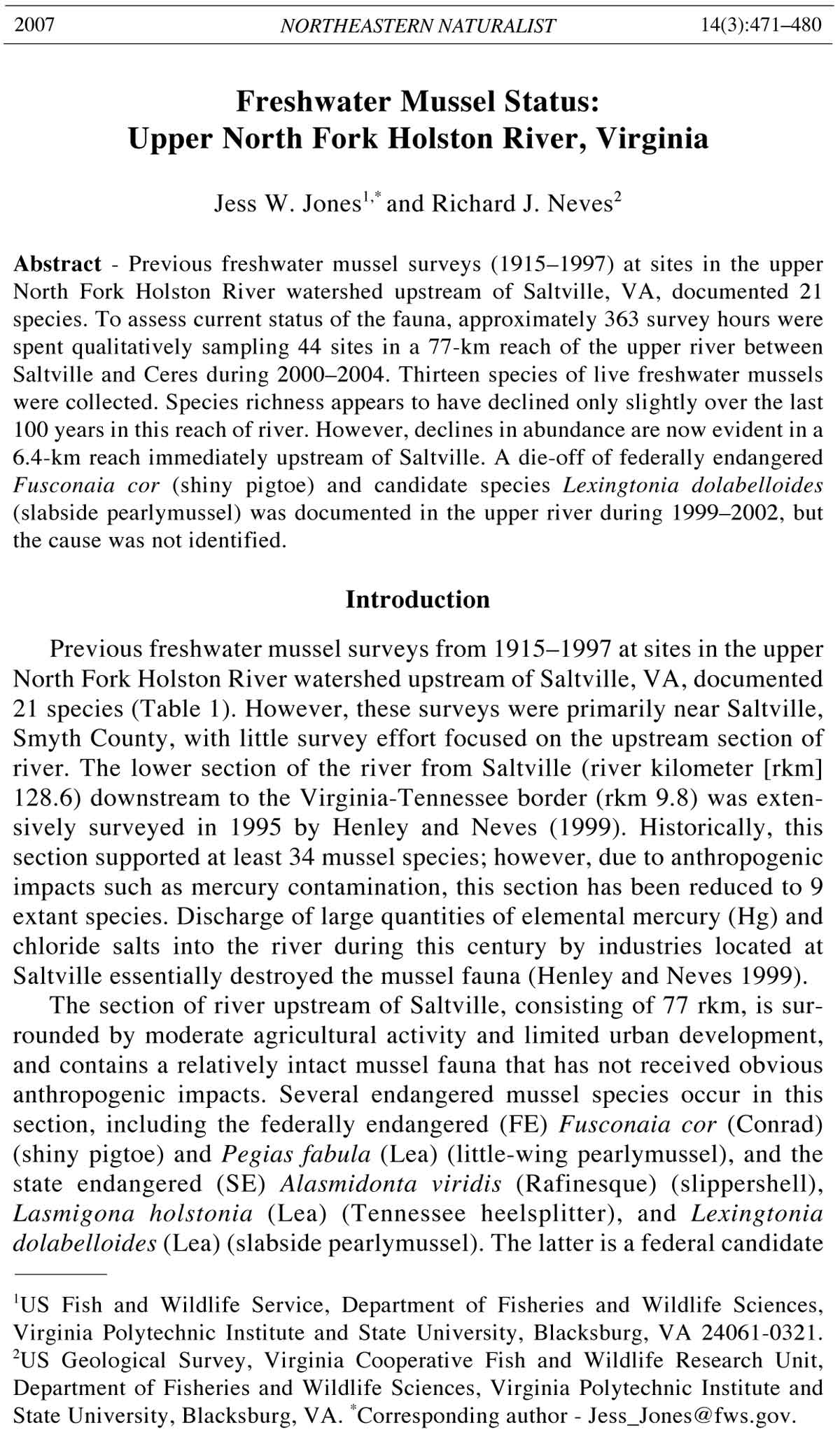
During the summers of 2000–2004, approximately 77 kilometers of the
upper North Fork Holston River (rkm 135.8–212.7) in Smyth and Bland
counties, VA, were surveyed for freshwater mussels (Fig. 1). The river flows in
a southwest direction and drains the Valley and Ridge Physiographic Province.
The stream bottom is mixed substrata underlain primarily with limestone and
shale. The upper river is fourth order in size and features moderate-to-high
2007 J.W. Jones and R.J. Neves 473
gradient riffle-run fluvial geomorphology. The majority of our survey sites
were located in the mainstem of the upper North Fork Holston River, from just
above Saltville upstream to Ceres. We also surveyed sites in second-order and
third-order tributary streams in this section (Laurel and Lick creeks). Topographic
maps with locations of collection sites are on file at the Virginia
Cooperative Fish and Wildlife Research Unit, Blacksburg, VA.
Qualitative sampling
Freshwater mussels were sampled at 44 sites (Fig. 1), selected by using 7.5-
minute US Geological Survey (USGS) topographic maps. Sampling sites were
chosen based on accessibility from roads or bridges, remoteness, and habitat
types (e.g., mainstem sites vs. tributary sites). The majority of our sampling
effort was focused in riffles and runs that contained suitable substrates for
freshwater mussels. Sites were surveyed by snorkeling, with 2–4 individuals
searching side-by-side and moving upstream. A few sites in tributaries were too
shallow for snorkeling; at these sites, we walked in an upstream direction
looking for live mussels protruding from the stream bottom. All fresh-dead or
relic shell material was also collected. Mussels were identified to species,
counted, and immediately returned to the substrate at their collection site.
Scientific names of mussels follow those of Turgeon et al. (1998), and the
conservation status of each species follows that of Williams et al. (1992).
Simple linear regression analysis was performed using total catch-perunit
effort (CPUE) (number of individuals/hour) data from each site and
regressed along river kilometers to derive the parameters of resultant
regression equations (SAS Institute 2001). At each site, snorkel distance
was measured with a range finder (Bushnell, yardage pro 400) or visually
estimated. Additional data and information on mussel, snail, and crayfish
abundance and occurrence, qualitative observations on stream habitat,
and comments on surrounding land use of each site are reported in Jones
and Neves (2005).
Figure 1. Sites qualitatively surveyed during 2000–2004 for freshwater mussels in
the upper North Fork Holston River, VA. Sites are reported as river kilometers or
creek sites.
474 Northeastern Naturalist Vol. 14, No. 3
Table 2. Number and CPUE (number of individuals/hour) of mussel species found alive at 36 sampling sites in the upper North Fork Holston River, Smyth and
Bland counties, VA.
River kilometer
Species 135.8 136.2 136.8 138.6 138.9 139.9 141.3 142.4 142.7 144.4 145.6 146.9
Villosa vanuxemensis 0 0 01 0 6 46 10 2 1 12
Villosa iris 2 28 2613 5 5 1618 3525 29 70
Lexingtonia dolabelloides 0 2 10 3 1 06 373 29 19 20
Medionidus conradicus 17 13 1 0 54 0 4 1 0 4
Ptychobranchus subtentum 0 0 00 0 0 00 00 0 0
Actinonaias pectorosa 10 11 1 1 15 4 13 4 3 17
Lampsilis fasciola 25 6 2 2 2 6 12 36 7 1 28
Pleurobema oviforme 0 0 00 0 0 00 21 0 2
Fusconaia cor 0 3 20 5 3 18 137 6 11 9
Ptychobranchus fasciolaris 11 3 0 4 4 8 15 12 12 11 2
Fusconaia barnesiana 0 0 00 0 0 00 10 0 0
Lasmigona costata 0 0 00 0 0 10 30 0 1
Lampsilis ovata 0 0 10 0 0 10 30 0 0
Total individuals/site 7 46 63 18 20 27 46 69 629 87 75 165
CPUE 1.2 3.7 6.3 1.0 2.2 3.4 4.6 5.7 21.3 10.9 10.0 9.7
River kilometer
Species 148.9 151.6 152.9 153.4 154.3 155.3 156.1 157.6 159.0 164.5 167.0 168.8
Villosa vanuxemensis 51 2 10 23 45 98 122 327 24 120 141 162
Villosa iris 69 14 22 30 37 48 48 235 20 134 145 195
Lexingtonia dolabelloides 44 57 28 96 30 11 1 1 1 3 0 0
Medionidus conradicus 11 0 26 115 70 115 51 123 17 29 57 18
Ptychobranchus subtentum 0 8 66 155 53 89 17 42 18 0 0 0
Actinonaias pectorosa 44 71 26 133 22 19 3 2 1 0 1 0
Lampsilis fasciola 38 27 14 29 7 25 7 28 2 15 16 18
2007 J.W. Jones and R.J. Neves 475
Table 2, continued.
River kilometer
Species 148.9 151.6 152.9 153.4 154.3 155.3 156.1 157.6 159.0 164.5 167.0 168.8
Pleurobema oviforme 5 3 11 23 5 12 5 3 2 8 25 15
Fusconaia cor 13 20 1 1 0 0 00 0 0 0
Ptychobranchus fasciolaris 10 26 17 42 14 12 2 3 1 1 0 0
Fusconaia barnesiana 0 0 00 00 04 05 10 2
Lasmigona costata 1 0 02 00 10 00 0 0
Lampsilis ovata 2 0 00 10 00 00 0 0
Total individuals/site 288 210 220 649 285 429 257 768 86 315 395 410
CPUE 14.4 35.0 22.0 81.1 95.0 30.6 28.5 31.3 5.7 42.0 30.4 39.0
River kilometer
Species 171.2 171.6 175.3 180.7 181.9 185.9 190.7 197.1 199.6 209.2 210.0 212.4
Villosa vanuxemensis 27 61 62 40 37 122 97 32 30 92 85 45
Villosa iris 25 76 38 27 47 48 65 26 4 4 0 0
Lexingtonia dolabelloides 0 0 10 00 00 00 0 0
Medionidus conradicus 10 22 15 0 1 1 2 0 0 0 0 0
Ptychobranchus subtentum 0 0 00 00 00 00 0 0
Actinonaias pectorosa 0 0 00 00 00 00 0 0
Lampsilis fasciola 3 15 5 01 4 3 1 0 00 0
Pleurobema oviforme 445 10 13704012 0 000
Fusconaia cor 0 0 00 00 00 00 0 0
Ptychobranchus fasciolaris 0 0 00 00 00 00 0 0
Fusconaia barnesiana 1 5 30 0 28 14 4 20 0 0
Lasmigona costata 0 0 00 00 00 00 0 0
Lampsilis ovata 0 0 00 00 00 00 0 0
Total individuals/site 70 224 134 68 89 273 221 75 36 96 85 45
CPUE 15.5 24.9 29.8 45.3 9.9 18.2 36.8 12.5 18.0 48.0 28.3 22.5
476 Northeastern Naturalist Vol. 14, No. 3
Results
Approximately 363 survey-hours were expended to sample the upper
North Fork Holston River between Saltville and Ceres. At each site in the
river, a mean of 10.1 person-hours was spent snorkeling for mussels, covering
a mean distance of nearly 395 m per site. Approximately 15.0 survey-hours
total were spent sampling two tributaries, Laurel Creek and Lick Creek. At
each site in these tributaries, a mean of 1.9 person-hours was spent snorkeling
and/or walking, covering a mean distance of nearly 65 m.
We recorded 13 species of live freshwater mussels, totaling 6980 individuals
at the 44 sites: 36 sites in the river (Table 2) and 8 sites sampled in
Laurel and Lick creeks (Table 3). These species, in order of relative abundance,
were as follows (Table 4): Villosa vanuxemensis (Lea) (mountain
creekshell) (27.1%), Villosa iris (Lea) (rainbow mussel) (23.3%), slabside
pearlymussel (10.4%), Medionidus conradicus (Lea) (Cumberland
moccasinshell) (10.3%), fluted kidneyshell (6.4%), Actinonaias pectorosa
(Conrad) (pheasantshell) (5.5%), Lampsilis fasciola (Rafinesque)
(wavyrayed lampmussel) (5.3%), Pleurobema oviforme (Conrad) (Tennessee
clubshell) (4.4%), shiny pigtoe (2.9%), Ptychobranchus fasciolaris
(Rafinesque) (kidneyshell) (2.9%), Fusconaia barnesiana (Lea) (Tennessee
pigtoe) (1.1%), Lasmigona costata (Rafinesque) (fluted shell) (0.1%), and
Lampsilis ovata (Say) (pocketbook) (0.1%). Juvenile mussels (individuals
less than 20 mm long) were observed of various species throughout the surveyed
reach of river, including juveniles of shiny pigtoe, slabside pearlymussel,
and fluted kidneyshell (Jones and Neves 2005). Species richness (2) and
abundances (1/hr.) at tributary sites were low, with the exception of Site 1
in Laurel Creek, which contained 24 individuals of 5 species: mountain
creekshell, rainbow mussel, Cumberland moccasinshell, wavyrayed
lampmussel, and Tennessee pigtoe (Table 3).
The only federally endangered species found alive during the survey was
shiny pigtoe. This species was found at 14 sites between rkm 136.2 and
154.3. Slabside pearlymussel (SE and FCS) was collected alive at 20 sites
between rkm 136.2 and 175.3. Fluted kidneyshell (FCS) was collected alive
at 8 sites between rkm 151.6 and 159.0. Two additional endangered species
Table 3. Number and CPUE (number of individuals/hour) of mussel species found alive at 8
sampling sites in tributary streams of the upper North Fork Holston River, Smyth, Bland, and
Tazewell counties, VA.
Sites
Laurel Creek Lick Creek
Species 1 2 3 4 5 1 2 3
Villosa vanuxemensis 5 0 0 0 0 2 1 0
Villosa iris 12 0 0 0 0 0 0 0
Medionidus conradicus 3 0 0 0 0 0 0 0
Lampsilis fasciola 2 2 0 0 0 0 0 0
Fusconaia barnesiana 2 0 0 0 0 0 0 1
Total individuals/site 24 2 0 0 0 2 1 1
CPUE 24 0.7 0 0 0 1 0.5 0.5
2007 J.W. Jones and R.J. Neves 477
were represented by the collection of shells only. One relic shell of littlewing
pearlymussel (FE) was collected at rkm 159.0 upstream of Riverside,
and several relic shells were collected downstream of the bridge at Nebo,
rkm 185.9. One fresh-dead shell of slippershell (SE) was found at rkm 157.6,
downstream of the State Route 630 Bridge at Riverside, VA, and one other
fresh-dead shell at rkm 154.3.
A plot of catch-per-unit effort (CPUE) regressed on rkm locations shows
a downstream pattern of decline in mussel abundance in the surveyed reach
of river (Fig. 2). However, mussel abundance based on CPUE at two sites
(rkm 153.4 and 154.3) was very high (outliers), which positively affected
CPUE in this lower reach downstream of the Route 633 Bridge (Fig. 2).
Even with these sites included in the regression analysis, the downstream
pattern of decline remains evident; if these two sites are removed from the
analysis, the pattern is highly significant (p < 0.001).
Discussion
Historical and recent mussel surveys have recorded 21 species in the 77-
kilometer reach of river between Saltville and Ceres (Adams 1915; Ahlstedt
and Saylor 1995–1996; D. Hubbs, Tennessee Wildlife Resources Agency,
Camden, TN, pers. comm.; Neves and Odom 1989; Neves and Widlak 1988;
Ortmann 1918; Stansbery and Clench 1974; Winston and Neves 1997). Our
study documented the presence of 13 live mussel species and shells of 2 other
species in this section, which is comparable to earlier studies (Table 1).
Additional specimens of slippershell (3 fresh-dead shells) were collected at
rkm 157.6 on 22 July 1999 (B. Beaty, The Nature Conservancy, Abingdon, VA,
pers. comm.); therefore, this species is likely extant in the river, but very rare.
Confirmation of an extant population of little-wing pearlymussel in the
river is more difficult. A status survey covering the known range of this
Cumberlandian species by Ahlstedt and Saylor (1995–1996) reported a
Table 4. Summary of mussel collections in the upper North Fork Holston River, Smyth and
Bland counties, VA.
Number Percentage Sites of Distribution
Species collected of collection occurrence range (rkm)
Villosa vanuxemensis 1897 27.1 32 138.6–212.4
Villosa iris 1629 23.3 34 135.8–209.2
Lexingtonia dolabelloides 727 10.4 20 136.2–175.3
Medionidus conradicus 723 10.3 26 135.8–190.7
Ptychobranchus subtentum 448 6.4 8 151.6–159.0
Actinonaias pectorosa 383 5.5 21 135.8–167.0
Lampsilis fasciola 367 5.3 31 135.8–197.1
Pleurobema oviforme 307 4.4 23 142.7–197.1
Fusconaia cor 202 2.9 14 136.2–154.3
Ptychobranchus fasciolaris 201 2.9 21 135.8–164.5
Fusconaia barnesiana 79 1.1 12 142.7–199.6
Lasmigona costata 9 0.1 6 141.3–156.1
Lampsilis ovata 8 0.1 5 136.8–154.3
Total 6980 100.0
478 Northeastern Naturalist Vol. 14, No. 3
small population in the upper North Fork Holston River. These authors
found 3 live, 1 fresh-dead shell, and 2 relict shells downstream of the bridge
at Nebo (rkm 185.9). Another live individual was collected in the summer of
1994 across from the USGS gauge station at rkm 136.8 (R.J. Neves, USGS,
Blacksburg, VA, unpubl. data). In addition, fresh-dead shells were collected
near Nebo in 2004 (S. Hanlon, US Fish and Wildlife Service, Abingdon, VA,
pers. comm.). However, the species is difficult to collect because of its small
size (adults <20–30 mm) and rare occurrence in the river. Thus, little-wing
pearlymussel probably still occurs in the river despite not being collected
alive in over 10 years, and should be considered part of the extant mussel
fauna.
The SE Tennessee heelsplitter was not found during this survey; however,
we only surveyed 3 sites at or upstream of Ceres, VA, where this
species was collected in the early 1990s (D. Hubbs, , pers. comm.). A more
intensive survey effort is needed in the headwater reaches to determine the
occurrence of this rare species in the river.
The last collections of Elliptio dilatata (Rafinesque) (spike) and Lemiox
rimosus (Rafinesque) (birdwing pearlymussel) in the North Fork Holston
River are those of C.C. Adams (1915) in the early 1900s; therefore, we
consider these 2 species as extirpated. Populations of other species known to
occur in the upper river, such as Alasmidonta marginata Say (elktoe),
Toxolasma lividus (Rafinesque) (purple lilliput), and Strophitus undulatus
(Say) (creeper), also are likely extirpated or extremely rare. These species
were recorded sparingly in past collections, and were represented by only
1–3 shells collected in muskrat middens or as relics (Neves and Odom 1989,
Figure 2. Plot of catch-per-unit effort (CPUE) data at each survey site, regressed on
river kilometers (rkm) in the upper North Fork Holston River, VA. The linear
regression equation is CPUE = -17.96 + 0.41 (rkm) (R2 = 7.8%, p = 0.099).
2007 J.W. Jones and R.J. Neves 479
Winston and Neves 1997). Thus, despite the possible loss of a few species
that occurred sporadically in the upper river, species richness in the North
Fork Holston River upstream of Saltville has declined only slightly in the
20th century. Based on the results of this survey and those conducted in
the last 10 years, we believe the extant mussel fauna in the upper North Fork
Holston River is comprised of at least 16 species.
Declines in mussel abundance now are evident in sections of the upper
river. The reach of river from the State Route 633 Bridge (rkm 142.7)
downstream to Saltville (rkm 135.8) shows evidence of population declines.
Typically, mussel abundance and richness increase with increasing stream size
(Ortmann 1918); however, the opposite trend was observed in this study. The
site at rkm 142.7 was one of the best sites in the river for shiny pigtoe and
slabside pearlymussel; however, evidence of a die-off primarily of these 2
species at this site was documented beginning in 1999 (Table 5). From 1999–
2002, we routinely monitored this site for shells several times each year to
determine the extent of the die-off. During this time period, we collected 348
dead slabside pearlymussels and 114 dead shiny pigtoe shells. The majority of
collected shells were fresh-dead, and many still contained decaying tissue. The
dead mussels appeared to have died in place, and none were collected in
muskrat middens. We also observed at that time that some of these dying
mussels would first close their shells tightly, and then seemed to waste away
until they eventually died and their shells opened again, exposing the decaying
soft-parts. The foot of these dying mussels typically appeared emaciated, and
approximately 50% of the mantle tissue was separated away from the inside of
each valve, creating a pocket of air between the valves and the mantle.
The cause for this die-off currently is unknown and under investigation;
the die-off now appears to be recurring from rkm 142.7 upstream to rkm
153.4 (S. Hanlon, pers. comm.). Furthermore, additional sites in this lower
reach, such as North Holston Ford (rkm 139.9) and the island at the USGS
gauge station (rkm 136.8), contained excellent mussel communities in the
late 1980s and early 1990s, but now those communities appear considerably
reduced (Neves and Odom 1989; Neves and Widlak 1988; R.J. Neves,
USGS, unpubl. data).
Conclusions
Species richness of mussel communities in the North Fork Holston River
upstream of Saltville, VA has declined only slightly over the last 100 years.
However, a noticeable decline in abundance in the last 10–15 years is now
evident in a 6.4-km reach of river immediately upstream of Saltville (rkm
Table 5. Mussels collected fresh-dead in the upper North Fork Holston River immediately
upstream (0–200 m) of the State Route 633 Bridge, Smyth County, VA.
Number collected
Species 1999 2000 2001 2002
Fusconaia cor 50 10 46 8
Lexingtonia dolabelloides 179 30 119 20
480 Northeastern Naturalist Vol. 14, No. 3
142.7–135.8). Despite this observed decline, juveniles and sub-adults of
various species were collected throughout the river, indicating that population
recruitment is still occurring for most species. We recommend that the
best remaining sites beginning at Rich Valley High School (rkm 156.1)
downstream to the Route 633 Bridge (rkm 142.7) be monitored for evidence
of further declines or die-offs of mussel populations in the river.
Acknowledgments
We would like to thank Jeff Allen who helped us conduct the survey, and the
landowners in Smyth, Bland, and Tazewell counties who granted us permission to
access the river through their properties.
Literature Cited
Adams, C.C. 1915. The variations and ecological distribution of the snails of the
Genus Io. Memoirs of the National Academy of Sciences 12:1–92.
Ahlstedt, S.A., and C.F. Saylor. 1995–1996. Status survey of the little-wing
pearlymussel, Pegias fabula (Lea 1838). Walkerana 8:81–105.
Henley, W.H., and R.J. Neves. 1999. Recovery status of freshwater mussels
(Bivalvia: Unionidae) in the North Fork Holston River, Virginia. American
Malacological Bulletin 15:65–73.
Jones, J.W., and R.J. Neves. 2005. A survey to evaluate the status of freshwater
mussel populations in the upper North Fork Holston River, Virginia. Final
Report. Virginia Cooperative Fish and Wildlife Research Unit, Department of
Fisheries and Wildlife Sciences, Virginia Tech, Blacksburg, VA. 45 pp.
Neves, R.J., and M.C. Odom. 1989. Muskrat predation on endangered freshwater
mussels in Virginia. Journal of Wildlife Management 53:934–941.
Neves, R.J., and J.C. Widlak. 1988. Occurrence of glochidia in stream drift and on
fishes of the upper North Fork Holston River, Virginia. The American Midland
Naturalist 119:111–120.
Ortmann, A.E. 1918. The nayades (freshwater mussels) of the upper Tennessee
drainage, with notes on synonymy and distribution. Proceedings of the American
Philosophical Society 57:521–626.
SAS Institute. 2001 Statistical analysis system. SAS Institute, Cary, NC.
Stansbery, D.H., and W.J. Clench. 1974. The Pleuroceridae and Unionidae of the
North Fork Holston River above Saltville, Virginia. Bulletin of the American
Malacological Union, Inc. for 1973:33–36.
Turgeon, D.D., J.F. Quinn, Jr., A.E. Bogan, E.V. Coan, F.G. Hochberg, W.G. Lyons,
P.M. Mikkelsen, R.J. Neves, C.F.E. Roper, G. Rosenberg, B. Roth, A. Scheltema,
F.G. Thompson, M. Vecchione, and J.D. Williams. 1998. Common and Scientific
Names of Aquatic Invertebrates from the United States and Canada: Mollusks.
Second edition. American Fisheries Society, Bethesda, MD. Special Publication
26. 526 pp.
Williams, J.D., M.L. Warren, Jr., K.S. Cummings, J.L. Harris, and R.J. Neves. 1992.
Conservation status of freshwater mussels of the United States and Canada.
Fisheries 18:6–22.
Winston, M.R., and R.J. Neves. 1997. Survey of the freshwater mussel fauna of
unsurveyed streams of the Tennessee River drainage, Virginia. Banisteria 10:3–8.

 The Northeastern Naturalist is a peer-reviewed journal that covers all aspects of natural history within northeastern North America. We welcome research articles, summary review papers, and observational notes.