2009 NORTHEASTERN NATURALIST 16(1):53–66
Dynamics of Macroalgal Blooms along the Cape Cod
National Seashore
Patrick Lyons1,2,*, Carol Thornber1, John Portnoy3, and Evan Gwilliam3
Abstract - Accumulations of nuisance drift macroalgae along the open coast Atlantic
beaches of the Cape Cod National Seashore have been observed on an anecdotal basis
for over 50 years. This entire stretch of coastline is sandy, with no solid substrata for
algal attachment. During the summer of 2006, we collected data on drift macroalgal
accumulations repeatedly throughout this National Seashore. Peak biomass (consisting
of several filamentous red species and green algae, primarily Ulva lactuca) was
found in early August, mainly at the northernmost site. Our data, together with ocean
current patterns and anecdotal evidence, suggest that macroalgae may originate in
rocky shorelines of northern New England and are transported south by Gulf of
Maine currents. Algae are most likely caught along the Cape Cod National Seashore
shoreline by sand bars, particularly in the northern part of the shoreline.
Introduction
Macroalgal blooms have received increasing attention in the scientific
community throughout the last few decades. Although less well studied
than toxic phytoplankton (Townsend et al. 2001), macroalgal blooms also
have important ecosystem functions such as providing habitat for invertebrates
(Hull 1987, Norkko et al. 2000) or fish (Kingsford 1995), and food
for herbivorous grazers (Salovius and Bonsdorf 2004). In addition, blooms
may cause hypoxic (indirectly) or anoxic conditions upon decomposition,
altering ecosystem function (Raffaelli et al. 1998). Blooms have also been
associated with the decline of corals (Bell 1992) and seagrasses (Peckol et
al. 1994) due to competition for nutrients and/or shading. Bloom-forming
species are typically characterized by thalli with large surface-area-tovolume
ratios (either thin and blade-like or filamentous and repeatedly
branched), allowing for fast uptake of nutrients (Littler and Littler 1980,
Lotze and Schramm 2000, Wallentinus 1984). Blooms most commonly
consist of green algae (Raffaelli et al. 1998, Valiela et al. 1997), but both
red and brown species of macroalgae can be bloom forming as well (Gross
1994). Common explanations for the occurrence of macroalgal blooms
include increased availability of nitrogen and/or phosphorus, as well as
changes in water circulation (Raffaelli et al. 1998). Wind-driven upwelling
events, which replenish nutrients, have also been linked to occurrences of
blooms (Kiirikki and Blomster 1996). In the northeastern United States,
1Department of Biological Sciences, University of Rhode Island, 100 Flagg Road,
Kingston, RI 02874. 2Current address - Department of Ecology and Evolution, State
University of New York at Stony Brook 650 Life Sciences Building, Stony Brook,
NY 11794. 3Cape Cod National Seashore, 99 Marconi Site Road, Wellfleet, MA
02667. *Corresponding author - plyons@life.bio.sunysb.edu.
54 Northeastern Naturalist Vol. 16, No. 1
several estuaries with frequent macroalgal blooms exist. Wilce et al. (1982)
and Gross (1994) both described seasonal blooms of Pilayella littoralis
(Linnaeus) Kjellan. in Nahant Bay, MA, which have occurred for at least
fifty years. Seasonal blooms of green algae such as Ulva and Cladophora
have been described in the Waquoit Bay Natural Research Reserve on the
south shore of Cape Cod, MA (Valiela et al. 1997). Vadas and Beal (1987)
and Vadas et al. (2004) described blooms of Ulva and Cladphora species
in Cobskook Bay, ME. In Narragansett Bay, RI, green and red macroalgal
blooms have been observed, particularly in Greenwich Bay (Granger et al.
2000; C. Thornber, unpubl. data).
The Cape Cod National Seashore (CCNS) is known for its extensive and
continuous Atlantic beaches, attracting swimmers, surfers, fisherman, and sunbathers
by the thousands. These sandy beaches are frequently fouled by filamentous
drift macroalgae during the summer. While Collins (1914) noted only
scattered remnants of drift algae on these shores, casual observations over
recent decades (Graham Giese, Provincetown Center for Coastal Research,
Provincetown, MA, pers. comm.) imply that although drift algae amounts vary
from year to year, they are becoming more abundant. In the late 1980s, macroalgal
accumulation caused repeated beach closures during late August at Head of
the Meadow Beach (Gross 1994). A few years later, in June of 1993, P. littoralis
was positively identified throughout the CCNS, particularly at Head of the
Meadow Beach (Gross 1994).
This occurrence is particularly interesting in that macroalgal blooms
are typically found in eutrophic estuaries, in which water residence times
are long enough for macroalgae to absorb large pulses of nutrients and form
blooms (Valiela et al. 1997). By contrast, the blooms at the CCNS occur
along well-flushed, open coastline. Furthermore, the entire stretch of shore is
sandy, with no hard substrate for algal attachment. Thus, it is likely that these
algae originate elsewhere and are transported to beaches at the CCNS via
physical processes, e.g., by coastal currents and/or by upwelling (Kiirikki
and Blomster 1996). Gulf of Maine coastal currents are largely counter
clockwise, running southward along the coast of Maine, New Hampshire,
and northern Massachusetts (see fig. 3 of Pettigrew et al. 2005). Thus, algae
are likely to be transported from northern New England. Where, when, and
at what rate algae are transported to the shore will have a large effect on their
spatial and temporal abundance. Local proliferation and deterioration rates
also are likely to be important and may be determined by algal density, nutrient
availability (Lotze and Schramm 2000), and herbivory (Salovius and
Bonsdorff 2004).
With this background, we identified three main objectives for our study:
1) establish a quantitative baseline of seasonal and spatial variation in the
density and species composition of drift macroalgae throughout the summer;
2) assess the relationship between algal density and water-column nutrient
concentrations, and 3) examine the hypothesis that drift macroalgae are
transported shoreward by upwelling events.
2009 P. Lyons, C. Thornber, J. Portnoy, and E. Gwilliam 55
Field-site Description
The entire outer shore of Cape Cod is characterized by shifting sand
bars. The southern stretch of the shore (sites 1–22, Fig. 1) contains
sand bars extending perpendicularly from shore forming a hook (referred
to as “J bars” hereafter, which accurately describes their appearance as
viewed aerially from offshore). Extending northwards (sites 22–26), a
sandbar runs parallel to the shoreline, almost acting as a barrier island. At
the northern end of Cape Cod (sites 27–40), J bars once again dominate
(Fig. 2). In the three months in which this study was conducted (June
through August, 2006), considerable sandbar movement was observed,
particularly of J bars, throughout this region.
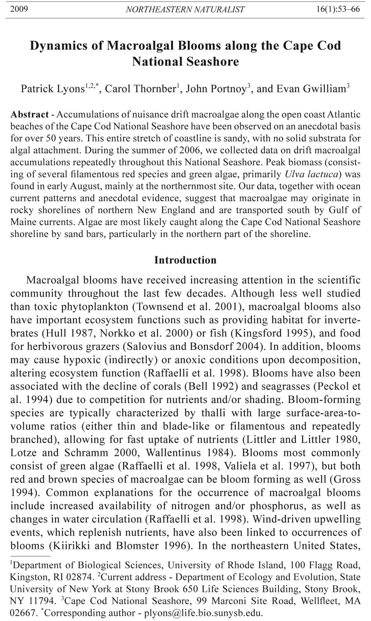
Figure 1. Field sampling sites along the Cape Cod National Seashore (CCNS). The
three sites where quantitative surveys were conducted are marked with black dots.
The sites (spaced equally at 1 km apart) where qualitative surveys were conducted
are marked with white dots; however, for clarity, only three of the forty qualitative
survey sites are shown. Bars represent site summer means (six survey dates) based on
the daily sum of qualitative subtidal and intertidal score (0–10) for algal abundance,
± 1 standard error.
56 Northeastern Naturalist Vol. 16, No. 1
Methods
Qualitative visual surveys
Shore-wide surveys were conducted biweekly, from 14 June to 23 August
2006 from Coast Guard Beach, Eastham, MA (Site 1) to Race Point Beach,
Provincetown, MA (Site 40), at 1-km intervals (Fig. 1), to assess macroalgal
abundance throughout the entire CCNS region. To allow for monitoring of
the entire shoreline, surveys were conducted visually from shore, using a
scale from 0 to 5 (See Tables 1 and 2 for scoring guide). No actual measurements
or collections were made to allow for rapid monitoring; thus the data
provide only relative abundances. Surveys were conducted at low tide so that
the macroalgal abundance could be assessed both on shore (intertidal) and in
the water out to 10 m from shore (subtidal); typically, algae would occur on
the beach most often at low tide, having been cast during the ebb tide (P. Lyons,
pers. observ.). At each site, the two levels (intertidal and subtidal) were
assessed separately and then summed together. We summed the data so that
estimate of overall abundance at each site could be determined, as often large
amounts of algae were present in the intertidal and absent in the subtidal or
vice versa. We used a Kruskal-Wallis test to determine differences in relative
algal abundance among sites.
Figure 2. Cape Cod National Seashore’s northern stretch of shoreline with J bars.
Taken by J. Portnoy on 8 May 2004.
2009 P. Lyons, C. Thornber, J. Portnoy, and E. Gwilliam 57
Quantitative surveys
Biweekly quantitative surveys of macroalgal abundance were conducted
from 14 June to 23 August 2006 at three beaches on the Atlantic shoreline of
CCNS (Head of the Meadow Beach, Truro; Cahoon Hollow Beach, Wellfleet;
and Coast Guard Beach, Eastham; Fig. 1); each are spaced approximately 12
km apart. All three beaches contained J Bars. At each beach, three random
locations were selected within a 1-km stretch using GIS software, and for
each location, algal biomass was measured during low tide in both 1.5 m water
depth (subtidal) and in the lower intertidal zone. Three subtidal samples
for each location were collected directly offshore; thus, nine collections
were made per sampling day per beach. We used a 40-cm long by 15-cm
diameter cylinder to collect approximately 10.5 L of ocean water for each
sample, from a depth of 0–40 cm. The seawater and drift algae were brought
to shore and filtered through a 1-mm sieve to remove all drift macroalgae.
Table 1. Intertidal survey scale assessed for area between mean tide level and mean low-tide
level.
Category Description
0. Absent No macroalgae present on the beach.
1. Sparse Some cover by macroalgae (0–10% of any given area). Sulfur dioxide
odor unlikely. Thin accumulations present (less than 1 cm thick), mostly
individuals occurring separately.
2. Mediocre Cover by macroalgae roughly 10–40%. Thin accumulations present but
thicker areas (0–2 cm thick) may occur. Odor possible in proximity
to macroalgae.
3. Masses Much cover by macroalgae (40–75% of any given area). Thickness
from 0–4 cm, with extremes up to 6 cm. Odor likely in proximity
and even several meters from macroalgae.
4. Complete coverage Generally, the whole area is covered with very few areas of exposed
sand. Depth ranges to 20 cm. Odor present throughout most of beach,
dependent on wind.
5. Severe Complete coverage. Depth of 20 cm or more. Odor powerful and present
well away from algae, dependent on wind.
Table 2. Subtidal surveys assessed for water extended from shore out 10 m.
Category Description
0. Absent No macroalgae present throughout the water column.
1. Sparse Some individual macroalgae scattered in water column on surface or
bottom. No large clumps.
2. Mediocre Some clumps present on bottom, in water column, or on surface. Macroalgae
mostly scattered.
3. Masses Large clumps present. Macroalgae may blanket the bottom or surface.
Difficulty in distinguishing clumps. Roughly half of the entire water
column contains macroalgae.
4. Saturated Large clumps present. Very little algal-free water. Some difficulty in
swimming would result.
5. Severe Large scale clumping. Entire water column full of macroalgae. Clumps
can’t be distinguished from water or other clumps. Wind induced
ripples absent, and wave dynamics appear altered. Much difficulty
swimming or just moving through the water.
58 Northeastern Naturalist Vol. 16, No. 1
The collected algae were later identified to species or genus (using Villalard-
Bohnsack 2003), and voucher specimens were preserved on herbarium paper
and on permanent slides. The total wet biomass of all algal material of each
sample was determined by first spinning all algae 20 times in a salad spinner
to remove excess water and then weighing the algae to the nearest 0.1 g.
For intertidal surveys, on each sampling date, a 10-m transect running
parallel to the shore in the lower intertidal was used for each location (thus
three transects per beach). The transect was placed approximately 0.5 m
above mean low water. We used a 0.25-m2 quadrat (subdivided into 100
squares), placed at 1-m intervals, to determine algal percent cover in each
quadrat for each of three groups: 1) Ulva spp. which consisted mostly of U.
lactuca Linnaeus but also included Ulva intestinalis Linnaeus; 2) filamentous
red/brown, which consisted mostly of the genus Polysiphonia; and,
3) other, which included all other species including green, red, and brown
algae. Group 3 species had larger thalli, but were typically rare (less than 2%
cover in individual quadrats); Appendix 1 contains a complete list of all macroalgal
species encountered. Algae in quadrats 1, 5, and 9 along each 10-m
transect were collected and brought to the lab to determine wet mass using
methods described above. Two-way repeated measure ANOVAs were used
(locations within the three beaches were kept the same from week to week)
to assess the effects of site and sampling date on both intertidal and subtidal
algal densities. It was found that data did not conform to the assumption of
sphericity, and thus the degrees of freedom were adjusted using Greenhouse
and Geisser’s Epsilon correction. All statistics here and below were run using
JMP 5.1 (SAS Institute, Cary, NC).
Nutrient assays
We collected water samples to determine dissolved inorganic nitrogen
(DIN) concentrations in the form of nitrate (NO3
-) and ammonium (NH4
+),
from the middle of dense macroalgal accumulations as well as areas free, or
relatively free, of macroalgae. Water samples were collected at both Head of
the Meadow Beach and Cahoon Hollow Beach, as both often had areas of dense
accumulation (Coast Guard Beach was usually completely free of algae). At
each beach, one sample was taken in a dense patch and another in an algal-free
patch during low tide on each sampling date. Macroalgal densities were measured
as above (see Quantitative surveys, subtidal sampling). All water samples
were analyzed by flow-injection analysis using a Lachat Quik-Chem™ system.
Correlations among nutrients (NO3
- and NH4
+, and total DIN) and subtidal macroalgal
densities were analyzed with logistic regression analysis.
Upwelling events
Temperature was recorded using HOBO® data loggers (Onset Computer
Corporation, Pocasset, MA) attached to buoys anchored by cinder
blocks in approximately 1.5 m of water (at low tide) at Head of the Meadow
Beach, Cahoon Hollow Beach, and Coast Guard Beach (Fig. 1). Data
were recorded at half-hour intervals from 31 May 2006 to 28 August 2006,
2009 P. Lyons, C. Thornber, J. Portnoy, and E. Gwilliam 59
and daily temperatures were averaged for each site. Wind data and daily
air temperature averages were collected for Chatham, MA from www.wunderground.
com. The occurrence of an upwelling event was based on the
satisfaction of three criteria: 1) the wind was consistently from the southwest
for at least 16 hours during the given day, 2) daily water temperature
was at least 1.5 °C lower than the previous day, and 3) daily air temperature
was at most 2.0 °C lower than the previous day. With the orientation
of the shore, a southwest wind would be needed to generate an upwelling
event, which would be marked by a decrease in water temperature due to
influx of cold bottom water. The third criterion was put in place to avoid
anomalous identification of upwelling events. Changes in subtidal and
intertidal macroalgal densities—wet mass per area (intertidal) or volume
(subtidal)—since the last sampling date as well as the time since the last
upwelling event were taken from the quantitative survey data. A one-way
ANOVA was used to assess the effects of the presence of an upwelling
event on the changes in intertidal and subtidal algal densities.
Results
Qualitative visual surveys
Significant differences in relative algal abundance (sum of both intertidal
and subtidal score) were found among the 40 sites (P < 0.001). Sites
29 through 34 had the highest mean abundances (1.4–2.3 relative summer
mean; Fig. 1). The week of 9 August had the highest overall algal densities
throughout the CCNS, matching our quantitative survey data (see below).
Quantitative surveys
Drift macroalgal densities were the highest during August, for both the
intertidal and subtidal zones, and varied significantly among sampling dates
(P = 0.005 and P = 0.0126, respectively; Tables 3 and 4, Figs. 3 and 4). Intertidal
densities were typically 1–2 orders of magnitude greater in August
than in June or July. Head of the Meadow and Cahoon Hollow beaches had
higher densities of macroalgae (2911.5 gm-2 and 243.9 gm-2 in the intertidal
during the week of 9 August) than Coast Guard Beach; this among-site variation
was significant for intertidal sites (P = 0.028) but not subtidal sites (P =
0.153) (Tables 3 and 4). The week of 9 August was the only sampling date
with measurable amounts of algae at Coast Guard Beach (37.0 gm-2 intertidal
and 0.08252 gL-1 subtidal). The most abundant species were Ulva lactuca
and Polysiphonia/Neosiphonia spp.
Nutrient assays and upwelling events
Water-column DIN (both NO3
- and NH4
+) varied inversely with subtidal
macroalgal density (r2 = 0.543, P = 0.037; Fig. 5). NO3
- was significantly negatively
correlated (r2 = 0.472, P = 0.013) with algal density, while NH4
+ was
not (r2 = 0.055, P = 0.575). Although several upwelling events were recorded,
their occurrence had no significant effect on either intertidal (F = 2.6202, P =
0.1664) or subtidal (F = 2.2466, P = 0.1942) algal density.
60 Northeastern Naturalist Vol. 16, No. 1
Discussion
A peak of algal density occurred during the second week of August in
the subtidal and intertidal sites for two of three beaches and in the last week
of August for the third beach. This closely matched our prediction based on
Figure 4. Subtidal algal densities (wet mass, gL-1) at the three quantitative survey
sites in summer 2006. Data are means ± 1 standard error.
Figure 3. Intertidal algal densities (wet mass, gm-2) for the three quantitative survey
sites in summer 2006; the Y-axis is in log scale. Data are means ± 1 standard error.
2009 P. Lyons, C. Thornber, J. Portnoy, and E. Gwilliam 61
previous findings (Gross 1994). However, unlike previous studies (Wilce et
al. 1982), we found very little P. littoralis in either the ball form described
by (Wilce et al. 1982) or in the linear form; our blooms were mainly composed
of Ulva spp. and Polysiphonia spp. We found the highest densities of
macroalgae at Head of the Meadow Beach, in both the intertidal and subtidal.
These results were substantiated by our shore-wide qualitative surveys,
which revealed a peak just north of Head of the Meadow Beach (Fig. 1).
Figure 5. Correlation between DIN and subtidal algal density from both sites (Head
of the Meadow Beach and Cahoon Hollow Beach). Solid circles denote NH4
+ (r2 =
0.055, P = 0.575), and open circles denote NO3
- (r2 = 0.472, P = 0.013).
Table 3. Results of a repeated-measures two-way AVOVA on intertidal macroalgal density
(g*m-2) among sites and sampling dates. Degrees of freedom were adjusted with G-G Epsilon
correction (see text), resulting in non-integer values. P values with asterisk are significant (P
< 0.05).
Source df (num, den) F P
Site 2.00, 22.00 4.232 0.028*
Sample week 1.74, 38.14 6.572 0.005*
Site*week 3.47, 38.14 7.198 0.004*
Table 4. Results of a repeated measures two-way AVOVA on subtidal density (g*L-1) among
sites and sampling dates. Degrees of freedom were adjusted with G-G Epsilon correction (see
text), resulting in non-integer values. P values with asterisk are significant (P < 0.05).
Source df (num, den) F P
Site 2.00, 23.00 2.039 0.153
Sample week 1.22, 27.98 6.471 0.013*
Site*week 2.43, 27.98 2.142 0.128
62 Northeastern Naturalist Vol. 16, No. 1
Temporal abundance patterns
Drift macroalgal blooms have typically been described in the literature
as following broadly consistent temporal trends in abundance. Blooms typically
peak in late summer (e.g., Berglund et al. 2003) due to light levels,
nutrient levels, water temperature, and other factors associated with seasonality.
We found that algal abundance along the CCNS did peak in August.
However, on smaller temporal and spatial scales, drift macroalgal biomass
was quite patchy. We found a significant negative relationship between algal
density and NO3
- concentration (Fig. 5), implying that algae are likely using
nutrients to proliferate while drifting, and their growth may be nutrientlimited
in dense aggregations (Escartin and Aubrey 1995). However, dense
aggregations (those characteristic of a 4 or 5 score on subtidal survey scale;
table 2) were only found at low tide and occasionally at most. Along the
CCNS, waves break closer to shore at high tide, acting to disperse aggregations
every 12 hours. Thus, algae may be rarely nutrient limited. We found
no significant relationship between algal abundance and upwelling events,
which are typically nutrient-rich (Kiirikki and Blomster 1996); however, we
did not investigate a potential relationship between upwelling events and
nutrient levels.
Sources of macroalgae
The large abundance of drifting macroalgae and lack of hard substrate
found along the CCNS imply that macroalgae are most likely transported
from other locations. While some macroalgae may originate from local
areas, this portion is likely a minor fraction of the total. Much of the offshore
bottom has been mapped and consists of sandy sediment, with little
habitat suitable for macroalgal attachment (Poppe et al. 2005). Upwelling
events could provide a means of transportation from offshore locations
to beaches, but no correlation between upwelling events and algal abundance
was found. Instead, we suggest that macroalgae drift from more
distant locations; the most likely mechanism is that drift algae originate
within the Gulf of Maine and are transported by the Western Maine Coastal
Current (WMCC) toward Cape Cod (Churchill et al. 2005; see Fig. 3 of
Pettigrew et al. 2005). Surface velocity of the WMCC ranges from 6 to
20 cm/sec during the summer months (May to September; Pettigrew et al.
2005); thus, dislodged algae could be transported from southern Maine to
Cape Cod rather quickly. For example, algae originating in Portland, ME
could be transported to Cape Cod (approximately 175 km) in ten days to
one month’s time. Gulf of Maine circulation and mixing of the WMCC
and the Eastern Maine Coastal Current (EMCC) have been linked to the
spread of the toxic red tide dinoflagellate, Alexandrium fundyense Balech,
throughout the Gulf of Maine (Townsend et al. 2001). The EMCC typically
contains higher levels of nutrients and A. fundyense cells (Townsend et al.
1987). It is possible that some of the same mechanisms affecting A. fundyense
spread may contribute to drift macroalgal accumulations along the
Atlantic shore of Cape Cod.
2009 P. Lyons, C. Thornber, J. Portnoy, and E. Gwilliam 63
Spatial patterns
Significant spatial variability occurred throughout the summer in macroalgae
density. Both quantitative and qualitative surveys indicate that the
shoreline just north of Head of the Meadow beach has the greatest algal
biomass. This pattern is consistent with our hypothesis that algae drift from
northern New England. This northern stretch of shoreline would be the first
to receive drift macroalgae via the southward flowing WMCC. In addition,
drogue studies (J. Manning, National Marine Fisheries Service, Wood’s
Hole, MA., pers. comm.) indicate that the extensive bar and shoal system
just east of the tip of Cape Cod acts to increase water residence times and
thus capture southward-drifting debris.
Drift macroalgae were not limited to the northern part of the shore. Accumulations
in the southern part of the shoreline occurred near J bars, which
could retain algae drifting southward, while macroalgae along the more
northern shoreline accumulated even in areas without J bars. It is probable
the stretch of beach between sites 22 and 26 (Fig. 1) had relatively little algae
due to a lack of J bars to concentrate southward drifting macroalgae (Paalme
et al. 2004).
The most southern part of the shore received very little algae throughout
the summer, except for the first week in August, even though this stretch
of shore does contain J bars that could locally retain algae. During early
August, large amounts of macroalgae did occur at the southern stretch of
shoreline, following a period of strong northwest winds. Thus, the general
occurrence of drift macroalgae, as well as site-to-site differences in accumulations
along CCNS’s Atlantic shoreline, appear to result from seasonal
production in waters north of Cape Cod, southward transport via Gulf of
Maine coastal currents, and capture of drift algae by the outer Cape shoal
and bar system. This study provides a repeatable protocol and quantitative
database for future assessments of trends in the timing, spatial distribution,
species composition, and abundance of drift macroalgae along the Atlantic
shore of Cape Cod.
Acknowledgments
Funding for this study was provided by a grant from the National Park Service
to C. Thornber. The Cape Cod National Seashore National Resource Department
provided trucks, lab space, housing, and equipment. Field assistance was provided
by Tracy Fayollat, Mary Hake, and Kathleen Kughen. Nutrient tests were run by Judith
Oset, Krista Lee, and Justin Rivera. Arthur Mathieson, Charles Roman, Robert
Wilce, and two anonymous reviewers provided helpful insights for the manuscript.
Graham Giese and Jim Manning provided considerable help with understanding local
coastal currents. Mark Adams provided help with GPS and GIS.
Literature Cited
Bell, P.R.F. 1992. Eutrophication and coral reefs: Some examples in the Great Barrier
Reef Lagoon. Water Research 26:553–568.
64 Northeastern Naturalist Vol. 16, No. 1
Berglund, J., J. Mattila, O. Ronnberg, J. Heikkila, and E. Bonsdorff. 2003. Seasonal
and inter-annual variation in occurrence and biomass of rooted macrophytes
and drift algae in shallow bays. Estuarine, Coastal, and Shelf Science 56:1167–
1175.
Churchill, J.H., N.R. Pettigrew, and R.P. Signell. 2005. Structure and variability of
the Western Maine Coastal Current. Deep-Sea Research 52:2392–2410.
Collins, F.S. 1914. Drifting algae. Rhodora 16:1–5.
Escartin, J., and D.G. Aubrey. 1995. Flow structure and dispersion within algal mats.
Estuarine, Coastal, and Shelf Science 40:451–472.
Granger, S., M. Brush, B. Buckley, M. Traber, M. Richardson, and S. Nixon. 2000.
An assessment of eutrophication in Greenwich Bay. In M. Schwartz (Ed.). Restoring
Water Quality in Greenwich Bay: A Whitepaper Series. Rhode Island Sea
Grant, Narragansett, RI.
Gross, V.A. 1994. Biological and oceanographic factors controlling the nuisance algal
bloom of free-living Pilayella littoralis in Nahant Bay, Massachusetts. M.Sc.
Thesis. Northeastern University, Boston, MA. 133 pp.
Hull, S.C. 1987. Macroalgal mats and species abundance: A field experiment. Estuarine,
Coastal, and Shelf Science 25:519–532.
Kiirikki, M., and J. Blomster. 1996. Wind-induced upwelling events as a possible
explanation for mass occurrences of epiphytic Ectocarpus silicuslosus (Phaeophyta)
in the northern Baltic Proper. Marine Biology 127:353–358.
Kingsford, M.J. 1995. Drift algae: A contribution to near-shore habitat complexity
in the pelagic environment and in attractant for fish. Marine Ecology Progress
Series 116:297–301.
Littler, M.M., and D.S. Littler. 1980. The evolution of thallus form and survival
strategies in benthic marine macroalgae: Field and laboratory tests of a functional
form model. American Naturalist 116:25–44.
Lotze, H.K., and W. Schramm. 2000. Ecophysiological traits explain species dominance
patterns in macroalgal blooms. Journal of Phycology 36:287–295.
Norkko, J., E. Bonsdorff, and A. Norkko. 2000. Drifting algal mats as an alternative
habitat for benthic invertebrates: Species-specific responses to a transient
resource. Journal of Experimental Marine Biology and Ecology 248:79–104.
Paalme, T., G. Martin, J. Kotta, H. Kukk, and K. Kaljurand. 2004. Distribution
and dynamics of drifting macroalgal mats in Estonian coastal waters during
1995–2003. Proceedings of the Estonian Academy of Sciences, Biology, Ecology
53:260–268.
Peckol, P., B. DeMeo-Anderson, J. Rivers, I. Valiela, M. Maldonado, and J. Yates.
1994. Growth, nutrient uptake capacities, and tissue constituents of the macroalgae
Cladophora vagabunda and Gracilaria tikvahiae related to site-specific
nitrogen loading rates. Marine Biology 121:175–185.
Pettigrew, N.R., J.H. Churchill, C.D. Janzen, L.M. Mangum, R.P. Signell, A.C.
Thomas, D.W. Townsend, J.P. Wallinga, and H. Xue. 2005. The kinematic and
hydrographic structure of the Gulf of Maine Coastal Current. Deep-Sea Research
52:2369–2391.
Poppe, L.J., V.F. Paskevich, B. Butman, S.D. Ackerman, W.W. Danforth, D.S. Foster,
and D.S. Blackwood. 2005. Geological interpretation of bathymetric and
backscatter imagery of the sea floor off Eastern Cape Cod, Massachusetts. US
Geological Survey, Coastal and Marine Geology Program, Woods Hole, MA.
Open-File Report 2005-1048.
Raffaelli, D.G., J.A. Raven, and L.J. Poole. 1998. Ecological impact of green macroalgal
blooms. Oceanography and Marine Biology 36:97–125.
2009 P. Lyons, C. Thornber, J. Portnoy, and E. Gwilliam 65
Salovius, S., and E. Bonsdorff. 2004. Effects of depth, sediment, and grazers on the
degredation of drifting filamentous algae (Cladophora glomerata and Pilayella
littoralis). Journal of Experimental Marine Biology and Ecology 298:93–109.
Townsend, D.W., J.P. Christensen, D.K. Stevenson, J.J. Graham, and S.B. Chenoweth.
1987. The importance of a plume of tidally mixed water to the biological
oceanography of the Gulf of Maine. Journal of Marine Research 45:699–728.
Townsend, D.W., N.R. Pettigrew, and A.C. Thomas. 2001. Offshore blooms of the
red-tide organism, Alexandrium sp., in the Gulf of Maine. Continental Shelf
Research 21:347–369.
Vadas, R.L., and B. Beal. 1987. Green algal ropes: A novel estuarine phenomenon.
Estuaries 10:171–176.
Vadas, R.L., B.F. Beal, W.A. Wright, S. Emerson, and S. Nickl. 2004. Biomass and
productivity of red and green algae in Cobskook Bay, Maine. Northeast Naturalist
11(Special Issue 2):163–196
Valiela, I., J. McClellan, J. Hauxwell, P.J. Behr, D. Hersh, and K. Foreman. 1997.
Macroalgal blooms in shallow estuaries: Controls and ecophysiological and ecosystem
consequences. Limnology and Oceanography 42:1105–1118.
Villard-Bohnsack, M. 2003. Illustrated key to the seaweeds of New England. Second
Edition. Rhode Island Natural History Survey, Kingston, RI.
Wallentinus, I. 1984. Comparisons of nutrient uptake rates for Baltic macroalgae
with different thallus morphologies. Marine Biology 80:215–225.
Wilce, R.T., C.W. Schneider, A.V. Quinlan , and K.V. Bosch. 1982. The life history
and morphology of free-living Pilayella littoralis (L.) Kjellm. (Ectocarpaceae,
Ectocarpales) in Nahant Bay, Massachusetts. Phycologia 21:336–354.
66 Northeastern Naturalist Vol. 16, No. 1
Appendix 1. Macroalgae species present during surveys conducted at Cape Cod,
MA. Superscripts refer to algal taxonomy: R = Rhodophyta (red), C = Chlorophyta
(green), P = Phaeophyceae (brown).
Commonly found during quantitative surveys, qualitative surveys, and observation.
Neosiphonia harveyi (J. Bailey) M.-S. Kim, H.-G. Choi, Guiry & G.W. Saunders R
Polysiphonia flexicaulis (Harvey) F.S. Collins R
Polysiphonia fucoides (Hudson) Greville R
Polysiphonia nigra (Hudson) Batters R
Polysiphonia stricta (Dillwyn) Greville R
Ulva lactuca Linnaeus C
Rarely found during quantitative surveys, qualitative surveys, and observation.
Callithamnion corymbosum (J.E. Smith) Lyngbye R
Ceramium virgatum Roth R
Chondrus crispus Stackhouse R
Cladophora albida (Nees) Kützing C
Codium fragile subsp. tomentosoides (Van Goor) P. C. Silva C
Ectocarpus siliculosus (Dillwyn) Lyngbye P
Palmaria palmata (Linnaeus) Kuntze R
Pilayella littoralis (Linnaeus) KjellmanP
Rhodomela confervoides (Hudson) P.C.Silva R
Ulva intestinalis Linnaeus C
Vertebrata lanosa (Linnaeus) T.A. Christensen R
Several Fucus and Laminaria species P