2009 NORTHEASTERN NATURALIST 16(1):85–100
Past and Present Distribution of New Brunswick Bur Oak
Populations: A Case for Conservation
Donnie A. McPhee1,* and Jude A. Loo1
Abstract - A survey was conducted in New Brunswick (NB) over 5 years (1996–
2000), to assess the status of Quercus macrocarpa (Bur Oak). Bur Oak in NB is
separated from the fringe of its contiguous native range by approximately 750 km.
Historically, the species occurred throughout the lower Saint John River Valley and
in the floodplains of the Grand Lake Complex. The range in NB has been reduced
and fragmented, and now consists of a few small populations, along with scattered
individuals, occupying a combined area of less than 5 km2. The most isolated of the
small populations in NB is at least 40 km from the nearest seed or pollen source.
Elements of a conservation strategy are presented, which include preservation of
existing stands by government and non-government organizations, landowner education,
and restoration planting in appropriate habitats.
Introduction
Quercus macrocarpa Michx. (Bur Oak) has a broad North American
distribution and may become more abundant in the northern portions of its
range as the climate warms (Iverson et al. 2005). The populations located
in New Brunswick (NB) are separated from the fringe of its present contiguous
range by approximately 750 km, and are 250 km from the nearest
population, located in Maine. Published species range maps imply that Bur
Oak can be found along the lower Saint John River Valley, stretching from
Woodstock to the city of Saint John and along the shores of the lakes in
the Grand Lake ecosystem and their floodplains (Farrar 1995, Hosie 1979,
Loucks 1962, Ritchie 1996).
The published range of Bur Oak in NB has been questioned because of
the lack of recent observations of the species in these areas. It is known
that much of the landscape, once appropriate for Bur Oak habitat, has been
cleared for agriculture at one time or another, but the degree to which the
distribution and frequency of the species has been reduced was unknown before
the present study. In 1996, a survey was initiated to assess the status of
Bur Oak in NB and to determine if a conservation strategy was warranted.
Species distribution and biology
Bur Oak is a member of the Quercus alba L. (White Oak) group. Its
contiguous native range extends from south-central Quebec, west to central
Manitoba, and funnels down into Texas, with isolated populations located in
1Natural Resources Canada, Canadian Forest Service – Atlantic Forestry Centre,
PO Box 4000, Fredericton, NB, Canada. *Corresponding author - dmcphee@nrcan.
gc.ca.
86 Northeastern Naturalist Vol. 16, No. 1
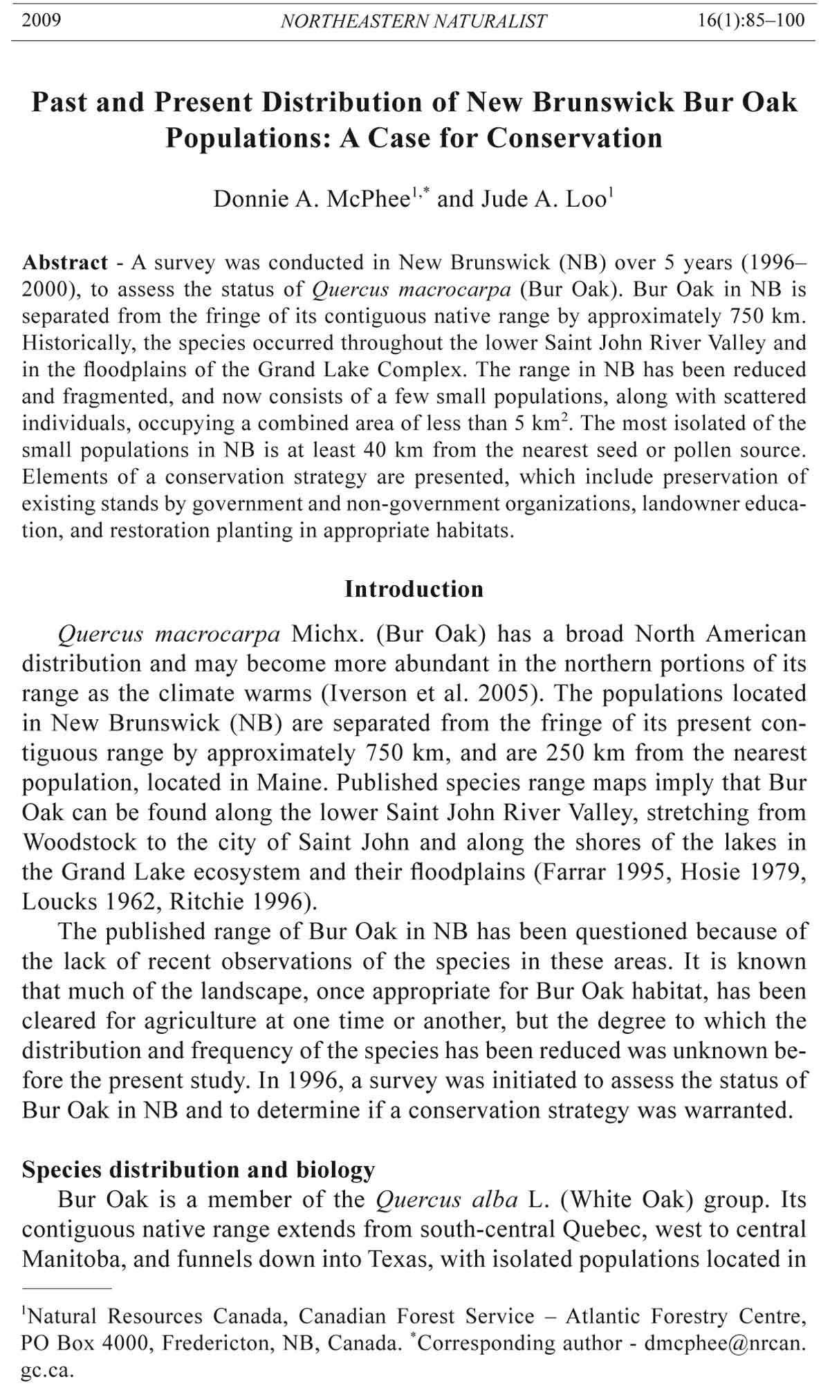
the New England states and in the province of NB (Fig.1). Bur Oak is considered
to be an important bottomland species throughout much of its northern
range, but tolerates a wide range of soil and moisture conditions, making it
an associate of many other tree species. It is one of the most drought resistant
of the North American oaks and is classified as intermediate in shade tolerance
(Farrar 1995, Hosie 1979).
Bur Oak is monoecious; male and female flowers are borne in distinct
catkins on the current year’s branchlets. The species is generally crosspollinated
by small, wind-dispersed pollen grains, for which models predict
a long dispersal distance of 199 km (Ducousso et al.1993). Reproductive
age spans 35–300 years, and good seed crops are produced every 2–3 years,
with either no or light crops in the intervening years. Bur Oak has very large
acorns that ripen within the year, drop from the tree at the end of the summer,
and are disseminated by gravity, Sciurus spp. (squirrels), Cyanocitta
cristata L. (Blue Jay), and water (Johnson 1990). These acorns, unlike most,
have low levels of tannic acid, and can be used as a source of human food
without requiring treatment. Dicke and Bagley (1980) reported that North
American First Nations people ground the sweet-tasting acorns into flour.
When plentiful, the acorns make up much of the diet of Blue Jays, Sciurus
vulgaris L. (Red Squirrel), and S. carolinensis Gmelin (Gray Squirrel). Aix
sponsa L. (Wood Duck), Odocoileus virginianus Zimmerman (White-tailed
Deer), Canis latrans Say (Coyote), Ursus spp. (bear), and Mus spp. (mice)
and other rodents also feed on Bur Oak acorns (Johnson 1990).
When open grown, Bur Oak crowns are usually rounded, but irregular,
with the trunk dividing into a number of radiating, crooked, and gnarled
Figure 1. Range map of Bur Oak (Quercus macrocarpa) (Little 1971).
2009 D.A. McPhee and J.A. Loo 87
branches. However, when grown in a stand, the crown is usually short, conical,
and composed of many horizontal branches. The trunk is straight and
tall. On good sites, mature trees grow 20 to 30 m in height, 90 to 120 cm
in diameter at 1.3 m above the ground, and live 200 to 300 years (Johnson
1990). The wood is considered to be moderately decay resistant and is not
commercially separated from White Oak. It is used for furniture, interior
finishing, flooring, and boat building. A plastic-like material called tyloses
plugs pores in the wood, making it capable of holding liquids; thus, it is ideal
for making barrels (Whitecomb 1985). The species is excellent for urban
planting because of its tolerance to automobile emissions, for shelter belts
because of its drought tolerance, and as a reclamation species for coal mine
spoils because it has fared well on spoils with a pH as low as 5.6 (Geyer and
Rogers 1972).
There are two recognized forms of the species, Quercus macrocarpa var.
macrocarpa Michx. (Southern Bur Oak) and Quercus macrocarpa var. oliviformis
(Michx. f.) Gray (Northern Bur Oak), of which the latter is found in
Canada and northern US states. Distinguishing characteristics between the
two varieties are in morphological and physiological attributes of the acorns.
Acorns from the northern variety are smaller and they overwinter, germinating
in the spring up to 8 months after falling, whereas acorns of the southern
form germinate soon after seed fall (Johnson 1990).
Historical context
The earliest record of human occupation of the forests of New Brunswick
dates back approximately 11,000 years ago, when people entered the Maritime
region from the south and southwest (Davis 1991). The first people to influence
NB forests were the Mi’kmaq and Malecite First Nations, but the degree
of disturbance they caused is not known. Early European missionaries and explorers
reported that fire in the woodlands was the greatest single disturbance
(Baird 1613, Denys 1672; both cited in McGee 1974), but there are no explicit
descriptions of First Nations people using fire in the region as a management
tool. Some First Nations are known to have planted Bur Oak as a source of
food near their communities (H. Likers, Mohawk council of Akwasasne, pers.
comm.), so the pre-European colonization distribution of Bur Oak in the region
may have been influenced by locations of Malecite communities.
Although the first European settlement in NB was attempted in 1604 on
Saint Croix Island, settlement was very slow and of little consequence until
after the American Revolution. Parenteau (1994) noted that the European
population of what is now NB was fewer than 5000 people in 1784. The colonist
population and resulting timber harvest continued to grow steadily but
slowly until 1805, when Great Britain offered massive protection to colonial
timber on the British market. Population growth followed this development:
from 20,000 people in 1800 to 80,000 in 1824 to 150,000 in 1840 (Journal
of the Legislative Assembly 1841). As a result, much of the prime land along
the Saint John River Valley was cleared for farming or was heavily logged
for timber (Bailey 1894). The conversion of the relatively stable floodplain
88 Northeastern Naturalist Vol. 16, No. 1
forest ecosystem to a landscape with a high degree of human disturbance
undoubtedly shifted the species composition (Clayden et al. 1984). Bur Oak
is one of several floodplain tree species severely affected by the reduction or
loss of this ecosystem.
Further historical evidence that human intervention was instrumental
in shaping the current distribution of Bur Oak in the province as isolated
peripheral populations, can be inferred from a study of wood sales recorded
in notary deeds in Quebec by Simard and Bouchard (1996). They described
how the pre-colonial forest of the Upper St. Lawrence Region changed during
the 19th century and reported that at the start of the recorded wood sales
in 1800–1809, Bur Oak was the most heavily sold tree, with more than twice
the combined sales of all other tree species. By 1850, oak had completely
disappeared from the market. The price remained high for oak wood until
1840, after which time it decreased. Simard and Bouchard (1996) concluded
that the decrease in oak wood sales could only be explained by the exhaustion
of the resource. At the same time, in New Brunswick, Perley (1843)
stated that carriage, sleigh, and boat builders all had great demand for Bur
Oak wood. He claimed that it was also one of the woods most prized by
farmers for agricultural implements.
Documented Bur Oak in New Brunswick
Bur Oak is documented in greatest abundance in the Grand Lake Lowlands
Ecoregion (Loucks 1962), a low-lying trough in south-central NB
encompassing the areas surrounding the Grand Lakes (Grand, Indian,
French, and Maquapit Lakes) and the broad valleys associated with the
Saint John and Oromocto rivers (Fig. 2) (Zelazny 1997). The region has the
warmest climate in the province, with an annual growing degree day (>5 °C)
total that sometimes exceeds 180 (Atmospheric Weather and Environment
Service 1993). The shallow, broad basin, within which are large bodies of
water, is less prone to the formation of frost pockets than elsewhere in the
province because of the moderating effect of the water. This moderation
reduces the number of late spring and early fall frosts, creating a long frostfree
season of approximately 150 days. The winter climate in the region is
more typical of the surrounding areas because the frozen lakes and rivers
have no moderating effect (Dzikowski et al. 1984).
Soils in the ecoregion—predominantly deep, heavy, clay loams—have
moderate to low fertility. The relatively flat topography and low elevation
(generally less than 45 m above sea level) are underlined with formations of
coarse-textured quartzose sandstone and fine-textured red siltstone of Carboniferous
origin (Colpitts et al.1995, Stobbe 1940). Imperfectly to poorly
drained fine sands, silts, and clays occur along the river flood plain.
The warm temperatures and extensive alluvial plains provide habitat
for several species in addition to Bur Oak that are at or near the northern
limit of their eastern range, including Acer saccharinum L. (Silver
Maple), Fraxinus pennsylvanica Marsh. (Red Ash), Fraxinus americana
L. (White Ash), Juglans cinerea L. (Butternut), Ostrya virginiana (P. Mill.)
2009 D.A. McPhee and J.A. Loo 89
(Hop-hornbeam), and Tilia americana L. (Basswood) (Zelazny 1997). Bur
Oak has also been documented historically in the Valley Lowlands Ecoregion,
where floodplains may host an assemblage of species similar to that
of the Grand Lake Basin Ecoregion (Ecosystem Classification Working
Group 2003, Zelazny 1997). The province of New Brunswick has ranked
Bur Oak as a species that “may be at risk” and is therefore a candidate for
research priority or detailed risk assessment (New Brunswick Department
of Natural Resources and Energy 2003) More recently, Bur Oak has received
an S-ranking of S2 by the Atlantic Canada Conservation Data Centre
(NatureServe 2008), indicating that the species is rare in the province,
thus making it vulnerable to extirpation.
In the present study, the historic range of Bur Oak was surveyed throughout
New Brunswick to determine accurately the current range, distribution,
and frequency of Bur Oak in the province and to determine if conservation
measures are warranted for these populations. In addition, a stand evaluation
was conducted to develop a prognosis for each population. The prognoses
were based on visual inspection of each population, including the production
of viable seedlings and the structure-class distribution.
Survey Methods
The survey was conducted in three stages in 1996–1997 throughout the
Saint John River Valley and Grand Lake Basin Ecoregion. The first stage
consisted of a literature review to determine and validate the historical range
of Bur Oak in New Brunswick. The second stage, during the spring of 1996,
focused on gathering evidence of recent occurrences, either documented or
anecdotal, collected by searching herbaria and communicating with local
botany experts. The final stage, conducted in the spring and summer of 1996
and 1997, consisted of a thorough search throughout the historical species
range as follows:
1) Road systems were driven. A large percentage of the floodplain and riverbanks
are visible from the extensive road system that lines the Grand Lake
Basin Ecoregion and Saint John River.
2) The waterways of the Grand Lake Basin Ecoregion were covered by boat
to gain access to areas not accessible by the road systems and to search
the islands and marshlands. All small lakes and inlets were surveyed. This
exercise was conducted in the early spring, before leaf flush, in order to see
the species’ distinct crown form. It also allowed access to a much higher
percentage of the actual floodplain of the ecoregion than would have been
possible later in the year.
3) Other areas considered to have a reasonable probability of having Bur Oak,
based on aerial photograph interpretation, that were not investigated during
the road and waterway surveys, were examined on foot.
Land ownership was determined for each Bur Oak site identified as
a result of this survey, and sites were revisited in the summer of 1997
for evaluation. The following information was collected during the site
evaluation: number of Bur Oak trees (approximate number in the largest
90 Northeastern Naturalist Vol. 16, No. 1
populations), area occupied by the population, structure classes of the
trees, physical habitat description, associated plant species, and present
and expected future land uses on the site and in surrounding areas. Finally,
current and future threats to the sites were deduced on the basis of present
and expected land use. All mature and sapling-sized trees were counted or
approximated, and seedling numbers were estimated by a thorough ground
search of each site and surrounding area. Trees were classified as mature if
they showed evidence of reproduction. Saplings were defined as trees taller
Figure 2. Ecoregions of New Brunswick: Ecoregion 7, Grand Lake Basin; Ecoregion
5, Valley Lowlands (Zelazny et al. 1997).
2009 D.A. McPhee and J.A. Loo 91
than 1.5 m, but reproductively immature; any tree shorter than 1.5 m was
considered a seedling. The population boundaries, along with individual
mature tree locations within the populations, were mapped on aerial photographs
and the area occupied by each population was calculated. A prognosis
for persistence of each stand beyond the present generation, based on production
of viable acorns and seedlings, was derived after four consecutive
summers (1996–1999) of field observations.
Results
Excluding individual trees or isolated clumps of small numbers of
trees (less than 10), there are eight populations of Bur Oak in NB, only one of which
has more than 500 mature trees (Table 1). In addition, only one of the eight
populations has protected status (Table 2). The rest are all on privately
owned land. Bur Oak is no longer found in much of its historic range in New
Brunswick, and many of the remaining stands are threatened by development
(Table 2). Most of the Bur Oak populations occur as mixed floodplain forest
patches, with Silver Maple and Acer rubrum L. (Red Maple) being the
two most commonly associated tree species. Seven of the eight sites where
Bur Oak is a major component are around the Grand Lake complex, and the
eighth site is on Belleisle Bay. In addition, the species can still be found
Table 1. Location and structure-class distribution of Bur Oak populations in New Brunswick,
Canada.
Population Approximate number of
# Name and location Mature trees Saplings Seedlings
1 Apple Island 65 100 150
2 Lakeville Corner 100 150 200
3 Denton Point 56 50 100
4 Douglas Harbour 200 100 200
5 Iron Bound Cove 59 0 200
6 Cox Point 500 500 1000
7 Jemseg 64 20 300
8 Erb’s Cove 49 25 30
Table 2. Ownership, land area, and threats to long-term survival of Bur Oak populations in New
Brunswick, Canada.
Approximate Time of
Population Ownership area* (ha) threat Type of threat
1. Apple Island Private 1.8 None None
2. Lakeville Corner Private 18.0 Current Development
3. Denton Point NB Nature Trust/ Private 2.4 None None
4. Douglas Harbour Private 9.0 Current Development
5. Iron Bound Cove Private 2.4 None None
6. Cox Point Private 360.0 Future Development
7. Jemseg Private 15.0 Current Grazing
8. Erb’s Cove Private 1.8 Current Harvesting
*Approximate area was obtained from aerial photographs.
92 Northeastern Naturalist Vol. 16, No. 1
as a minor component in the Cambridge Narrows area and a few isolated
trees occur in Keswick Ridge and surrounding areas (Fig. 3). All of the New
Brunswick populations occur in narrow bands on floodplains or riverbanks,
and the most frequently associated shrub and herbaceous species are typical
of bottomland ecosystems (Table 3). Each of the sites and associated threats
are briefly described below.
Apple Island (Population 1), located in the middle of French Lake, appears
to be relatively undisturbed. The landowner has no current plans to
alter the island’s natural state. The small stand is located on a floodplain in a
shallow cove on the west end of the island and has a fairly even representation
of structure classes. There is a noticeable absence of Bur Oak on the
shores of the rest of the island, where the banks are characterized by steep
rocky slopes and are exposed to high winds and lashing waves.
Lakeville Corner (Population 2) is located at the mouth of the “Blind
Thoroughfare,” a narrow strait, which runs between the French and Maquapit
Lakes. The property is owned by three private landowners and is under
serious threat due to residential and cottage development. The population
consists of a wide range of structure classes, including acorn-producing,
Figure 3. Remaining Bur Oak populations in New Brunswick.
2009 D.A. McPhee and J.A. Loo 93
mature trees. The site is a combination of river meadow and floodplain, with
the floodplain gradually rising into agricultural land, where a few mature
acorn-producing trees persist. In 1995, the stand was estimated to cover an
area of approximately 22 ha. This was reduced in 1997 by 4 ha, and again in
1999 by another 4 ha.
Denton Point (Population 3) is partially owned by the Nature Trust of
New Brunswick. The small population, located on a 25-m wide strip of forested
floodplain in a small sheltered cove, is the only Bur Oak site in New
Brunswick that has legal protected status. The entire floodplain on either side
of the protected area is currently being developed for summer homes.
A large population, consisting of a wide range of size classes, is located
on the floodplain of Douglas Harbour and on Earl Island (Population 4). The
population is located on a narrow strip, approximately 30 m wide, around
the edge of the island and along the shore of the cove. Biologically, the
population appears to be viable, with adequate regeneration and survival of
seedlings for long-term persistence, but the area is slowly being reduced.
Recently, the island has been subdivided and advertised on the real estate
market. The shores of the harbor continue to be developed for residential
purposes, constituting a serious and immediate threat to this population.
Iron Bound Cove (Population 5) is located at the far northeast end of
Grand Lake where the Salmon River empties into the Salmon Bay. The
population, consisting of mature trees and seedlings with a noticeable absence
of saplings, is located in a small cove, protected by an island running
parallel to the shore for approximately 600 m. The Bur Oak trees at this site
are situated on the floodplain of the shallow cove and on the island, which is
typical floodplain terrain. The area inland from the site is an active open-pit
Table 3. Common associated species at Bur Oak sites.
Species Common name Preferred habitat*
Acer rubrum L. Red Maple Moist, well-drained, sandy loams
Acer saccharinum L. Silver Maple Moist bottomlands, freshwater
shores
Alnus rugosa Du Roi Spreng. Speckled Alder Wet areas along streams and in
swamps
Fraxinus pennsylvanica Marsh. Red Ash Wet bottomlands, near waterways
Agrostis scabra Willd. Fly-away Grass Lake shores and bog trails
Cornus sericea L. Red Osier Meadows and shores
Ilex verticillata L. Winterberry Swampy or boggy open woods
Maianthemum canadense Desf. Wild Lily-of-the-valley Moist, usually acid woods
Onoclea sensibilis L. Sensitive Fern Wet open woods and meadows
Osmunda claytoniana L. Interrupted Fern Moist woods and thickets, bottomlands
Rubus pubescens Raf. Swamp Red Raspberry Moist thickets, woods, and shores
Smilax herbacea L. Jacob’s Ladder Alluvial woods, shores, and
meadows
Spiraea alba Du Roi Meadow Sweet Meadows and shores
Vaccinium myrtilloides Michx. Velvet Leaf Blueberry Clearings, thickets, peat bogs
*From Hinds (2000).
94 Northeastern Naturalist Vol. 16, No. 1
coal mine, which has been completely stripped of all vegetation in the recent
past. The area hosting Bur Oak has recently been purchased from the mining
company by a private landowner. At present, the site appears to be safe from
further habitat loss, as the new landowner has expressed an interest in site
reclamation and in the re-establishment of the Bur Oak forest to the areas
that have been disturbed by past mining operations.
Cox Point (Population 6) is located on a peninsula at the northeastern
end of Grand Lake and constitutes the largest continuous population in the
province. The edge of the peninsula has numerous inlets and coves that
host small pockets of regenerating Bur Oak. The peninsula is not uniformly
low-elevation floodplain, having scattered small hills and knolls; however,
many of the inlets stretch from one side of the peninsula to the other, so
Bur Oak occurs throughout the entire area. There are currently no known
development plans for the site, which has a single owner. However, considering
its highly valued location and the growing interest in summer cottage
development in the area, the site is not secure in the absence of legislated
protected status.
The Jemseg population (Population 7) is divided between two distinct
land uses. The largest area was, until recently, used as pasture land. Fortyfour
mature Bur Oak trees were left to provide shade for cattle and although
many of the trees produced acorns, there was no regeneration present on
the site until 2 years following the removal of the cattle. Approximately
one-third of the 44 trees show signs of severe deterioration, and appear to
be past their reproductive years. A small wooded area adjacent to the pasture
(0.4 x 0.2 km) extends from the floodplain and rises to approximately
25 m over a distance of 200 m. A group of 20 mature trees, with ample
regeneration, occurs in this forested section, which has two owners, neither
of whom expressed any plans for clearing the area. However, over the
course of this study, two new homes were built on the site, resulting in a
loss of 2–3 ha of habitat.
The eighth and smallest distinct population (Population 8), is located
in the Valley Lowland Ecoregion at the far end of Erb’s Cove on Belleisle
Bay, on the slopes of the steep ravine that forms the banks of Peters Brook.
There is little regeneration and, due to the economic value of the wood to
the landowner, there is a constant threat of harvesting. The landowner relies
on harvesting fuel wood for his major source of income. The cove is typical
floodplain and is currently used as cow pasture.
In addition to the eight populations of Bur Oak located by this survey,
scattered individual trees were mapped throughout the Saint John River Valley
and Grand Lake region. The area from Woodstock to Keswick Ridge,
a distance of more than 80 km, revealed only two young trees (approx. 50
years old) located on an upland slope approximately 20 km west of the Mactaquac
dam. Neither tree produced acorns during the course of this survey.
The river valley from Keswick Ridge to Gagetown Island, approximately 60
km in length, revealed only two Bur Oak sites. Three mature trees occur on
the front lawn of an active dairy farm in Keswick Ridge, and five trees persist
2009 D.A. McPhee and J.A. Loo 95
in Maugerville on floodplain that is currently used as pasture land. The trees
at both of these locations produce acorns; however, because of the location
of the trees, no seedlings have survived.
The Grand Lake region also contains a few scattered pockets of Bur Oak
with fewer than 40 trees. Eight trees occur on the lawns of lakeshore cottages
at the northwestern corner of French Lake, and Maquapit and Grand
Lakes have scattered individual mature trees located along their northern
shores. However, little to no regeneration has been observed in the areas
surrounding the trees. In 1996, a small pocket of mature trees was located
at Flowers Cove on Grand Lake; however, they were cleared for cottages
sometime between the springs of 1996 and 1998.
Nine mature trees were found along the river’s edge just north of the
village of Gagetown. Two mature trees, 15–20 saplings, and numerous seedlings
were located on the east side of Hart Lake. This area was once farmed,
but has been abandoned for approximately 20 years. Twenty-eight mature
trees were located along a 4.5-km section of the eastern bank on the Jemseg
River, but there was very little regeneration occurring at this site. Five trees
remain at Cambridge Narrows, and two in Springfield. These trees produce
acorns; however, all were surrounded by active farmland and no regeneration
was observed.
Discussion
Outside of New Brunswick
Bur Oak is one of the most widespread of all the white oaks. Throughout
its contiguous range, there is little concern about its viability. However,
in the New England states, where it occurs as small isolated populations,
little has been published or is known about its status. NatureServe compiles
information from Natural Heritage programs in the US and Conservation
Data Centers in Canada on occurrences of uncommon species throughout
North America. Information provided by NatureServe (February 2008) provided
a status ranking for Bur Oak in the northeastern US of SR for Maine
and Vermont, indicating that its status is unknown. Bur Oak is listed in the
“Checklist of Vascular Plants of Maine” (Campbell et al. 1995) in seven
counties, and is not considered to be rare (D. Cameron, Maine Department
of Conservation, Augusta, ME, pers. comm., February 2008). In Vermont,
Bur Oak is known to occur in all six counties bordering Lake Champlain,
and is not viewed as a species of concern by the Vermont Fish and Wildlife
Department (B. Popp, VT Fish and Wildlife Department, Waterbury, VT,
pers. comm., February 2008). In New Hampshire and Maryland, Bur Oak’s
rank is S1, denoting critically imperilled (1 to 5 occurrences, with 1000 or
less individuals; B. Nichols, The Nature Conservancy, Concord, NH, pers.
comm., February 2008), whereas in Massachusetts and Connecticut, Bur
Oak has a ranking of S3, denoting uncommon or restricted range. Currently,
Bur Oak has an S ranking of S3S4 in Quebec (uncommon in the northeast,
96 Northeastern Naturalist Vol. 16, No. 1
but becoming apparently secure in the lower southwestern St. Lawrence
River Valley), and S4 (secure) in New York. In Ontario, it is listed as S5,
indicating that it is widespread, abundant, and secure throughout its range
in the province. Natural Bur Oak occurrence outside ornamental plantings
has never been documented in either Nova Scotia or Prince Edward Island
(NatureServe 2008).
Within New Brunswick
It is apparent that the distribution and abundance of Bur Oak have
been reduced in New Brunswick. The question is whether this reduction
has been so severe that the species is threatened both in terms of genetic
diversity and its persistence in the province. If so, what might be the consequences
of losing the species from New Brunswick?
Herbarium records (1880–1995), along with historical literature, support
published species range maps for Bur Oak in New Brunswick. These records
indicate that Bur Oak, although never a common species, did occur in scattered
pockets along the lower Saint John River Valley, between Woodstock
and the city of St. John. Today, with the exception of a few scattered trees,
the range of Bur Oak in New Brunswick has been reduced to a combined
area of less than 500 ha, of which only 2.4 ha is protected. With no known
historic environment-, insect-, or disease-related causes, human intervention
(specifically, land clearing for development) is the likely cause of the decline
of Bur Oak in New Brunswick.
The history of the Saint John River Valley includes over 200 years of
intense agriculture and logging along the river, lakeshores, and floodplains,
with most areas having been cleared at one time or another (Power and Matson
1995). Dam construction for hydroelectricity at Beechwood (1957) and
Mactaquac (1968) has permanently flooded sections of the Saint John River
natural floodplain. Hinds (1983) determined that the flooding caused by
these dams was responsible for the elimination of four vascular plants (Solidago
ptarmicoides (Nutt.) Nesom [Prairie Goldenrod], Celastrus scandens
L. [American Bittersweet], Desmodium glutinosum (Muhl. ex Willd.) Wood
[Largeflower Tickclover], and Sporobolus asper (Michx.) Kunth [Composite
Dropseed]) from the provincial flora of New Brunswick. In addition,
the historical bottomland habitat upriver of the Mactaquac dam, where Bur
Oak populations likely occurred, has been flooded and no longer exists. The
two young trees discovered near Bear Island may be remnants of a previous
population in the area of the original floodplain.
Human demands continue on land that provides suitable habitat for Bur
Oak and other floodplain species. From the beginning of this study in 1996
until 1999, many areas along the river and lake shores have been altered as
a result of upgrading highways, cranberry field development, construction
of marinas, and residential or cottage development. Of the eight identified
populations, three are currently threatened by development of homes and
cottages. As indicated by the common flora at these sites (Table 3), they are
2009 D.A. McPhee and J.A. Loo 97
all naturally poorly drained and would not historically have been considered
“prime” real estate. However, increased demand for new waterfront
cottage lands combined with the use of fill, the ease of road construction,
and wetland drainage has rendered these once remote and inaccessible sites
popular development areas. Mature trees are sometimes left as shade trees at
sites developed for cottages (e.g., at Lakeville Corner, Douglas Harbour, and
Jemseg), giving the appearance of an intact stand. However, a stand under
such conditions will likely only persist as long as the existing trees survive,
and thus cannot be considered to be part of a viable population.
Currently, there appears to be little demand for Bur Oak wood as a lumber
species; however, this may be due to the lack of supply. There are two
local anecdotes about Bur Oak being harvested for its timber, involving the
populations of Douglas Harbour and Jemseg. In Douglas Harbour, the current
landowner recalls a local sawmill owner approaching his parents in the
early 1960s, and being granted the right to harvest a number of mature trees.
During the early 1980s, a local researcher with the Canadian Forest Service
(CFS) visited a landowner in the Jemseg area to inquire about the Bur Oak
on his property. The landowner was hauling the trees off to a sawmill as the
researcher arrived at the property (D.P. Fowler, CFS (retired), Fredricton,
NB, Canada, pers. comm.). Additional harvesting of Bur Oak in the region
(Lakeville Corner, Douglas Harbour, Flower’s Cove, and Erb’s Cove) has
been a result of encroachment, with the Bur Oak wood, along with other
floodplain hardwoods, being used for fuel.
Bur Oak is a phenotypically plastic species, adapted to warmer climates
in most areas of its broad range. It is one of the species that may be expected
to move into the Maritime region as climate warming occurs. Bur Oak occurring
in New Brunswick is adapted to the photoperiod of this latitude and,
if sufficient genetic diversity exists in the remaining small populations, they
would form the nucleus of the northward expanding distribution of the species
into the region.
The distribution and abundance of natural Bur Oak populations are still
shrinking in New Brunswick (as shown by the clearing of portions of both
the Lakeville Corner and Douglas Harbour populations during the course of
this study), potentially resulting in the loss of valuable genetic variation in
adaptively important traits in these outlying populations. Outlying populations
sometimes contain atypical genetic variation in response to harsher
environments at the edges of the ecological range of the species. Such genetic
variation may contribute to the processes and systems that are likely to provide
future adaptive potential for the species (Lesica and Allendorf 1995). With climate
change models predicting an increase in mean annual temperatures as
high as 3 °C, plant species’ ranges could theoretically shift on the order of 500
km in the next century (Falk et al. 1996, US Forest Service 2008). Northern
outliers of a generally more southern species, such as Bur Oak in New Brunswick,
may become important sources of genetic material, giving the species an
advantage through long-term climate changes and species range shifts.
98 Northeastern Naturalist Vol. 16, No. 1
Conclusions and Recommendations
Conservation measures are required to maintain natural populations of
Bur Oak in New Brunswick, and restoration is recommended to expand the
current distribution. The first and most basic step is education, ensuring that
those who have an influence on existing Bur Oak populations, including
owners, government departments, and non-governmental land-protection organizations,
are aware of the status and the need for conservation. Although
current landowners have been made aware of the status of the species and the
rationale for conserving populations, the fact that all of the unprotected sites
are privately owned on land having significant development value, means
that the populations face a high degree of insecurity.
Land trusts have expended some efforts on acquiring Bur Oak sites, but
they are limited in the purchase prices they can offer; for example, they may
not be allowed to exceed the assessed value of the land, which is influenced by
flood maximums. Because of the high and increasing demand for such land for
cottage development, however, the landowners can often obtain more than the
assessed value on the open market and are thus unlikely to sell the land at the
lower price that can be offered by a land-conservation organization. Efforts to
acquire land or to establish easements must, however, continue.
Restoration holds promise, as the trees grow well on a variety of sites,
and woodlot owners in southern and central New Brunswick have demonstrated
an interest in planting Bur Oak on their land. Ideally, a local nursery
will become interested in providing locally adapted stock to landowners.
Seed should be collected from as many trees in as many populations as possible,
and seedlings should be distributed to interested landowners in areas
where the species was once found.
Acknowledgments
The authors would like to thank Preeti Ramprasad, Beth Arsenault, and Kathleen
Forbes for their assistance in surveying and ground proofing Bur Oak sites, Don
Fowler and the late Hal Hinds for their guidance in getting this survey up and running,
the many private woodlot owners for allowing us to conduct this survey on
their lands, and the New Brunswick Department of Natural Resources for providing
helpful mapping information. We thank Dale Simpson, Vince Zelazny, and two
anonymous reviewers for kindly reviewing the manuscript.
Literature Cited
Atmospheric Weather and Environment Service. 1993. Canadian climate normals
1961–1990: Atlantic Provinces. Environment Canada. AES Publishers, Ottawa,
ON, Canada. 105 + iii pp.
Bailey, J.W. 1894. The Saint John River in Maine, Quebec, and New Brunswick.
Fisher Library, Woodstock, NB. (Cited in A. MacDougall and J. Loo. 1997.
Natural History of the Saint John River Valley Hardwood Forest of Western New
Brunswick and Northeastern Maine. Natural Resources Canada, Canadian Forest
Service – Atlantic Forestry Centre, Fredricton, NB, Canada. Information Report
M-X-2004E. 62 pp.)
2009 D.A. McPhee and J.A. Loo 99
Baird, P. 1613. Jesuit relations. Paris, France. (Cited in S.G. Lutz. 1997. Pre-European
settlement and present forest composition in King’s County, New Brunswick,
Canada. Master of Forestry Thesis. University of New Brunswick, Fredericton,
NB, Canada. 48 pp.)
Campbell, C.S., H. Adams, P. Adams, A. Dibble, L.M. Eastman, S.C. Gawler, L.
Gregory, B. Gnunden, A.D. Haines, K. Jonson, S.C. Rooney, T.F. Vining, J.E.
Weber, and W.A. Wright. 1995. Checklist of the vascular plants of Maine. Third
revision. Maine Agricultural Experiment Station, Orono, ME. Technical Bulletin
844.
Clayden, S.R., D.F. McAlpine, and C. Guidry. 1984. Rare and Vulnerable Species
in New Brunswick. Natural Science No. 2. The New Brunswick Museum, Saint
John, NB, Canada. 95 pp.
Colpitts, M.C., S.H. Fahmy, J.E. MacDougall, T. Ng, B.G. McInnis, and V.F.
Zelazny. 1995. Forest soils of New Brunswick. CLBRR Contribution No. 95-38.
Agriculture and Agri-Food Canada and New Brunswick Department of Natural
Resources and Energy, Fredericton, NB, Canada. 51 pp.
Davis, S. 1991. The Micmac. Four East Publications, Tantallon. NS, Canada. (Cited
in S.G. Lutz. 1997. Pre-European settlement and present forest composition in
King’s County, New Brunswick, Canada. Master of Forestry Thesis. University
of New Brunswick, Fredericton, NB, Canada. 48 pp.)
Denys, N. 1672. The description and natural history of the coasts of North America.
Reprinted at the Champlain Society in Toronto, ON, Canada, 1908. (Cited in S.G.
Lutz. 1997. Pre-European settlement and present forest composition in King’s
County, New Brunswick, Canada. Master of Forestry Thesis. University of New
Brunswick, Fredericton, NB, Canada. 48 pp.)
Dicke, St. G., and W.T. Bagley. 1980. Variability of Quercus macrocarpa Michx. in
an eastern Nebraska provenance study. Silvae Genetica 29(5–6):171–177.
Ducousso, A., H. Michaud, and R. Lumaret. 1993. Reproduction and gene flow in the
genus Quercus L. Annales des Sciences Forestières 50(1):91s–106s.
Dzikowski, P.A., G. Kirby, G. Read, and W.G. Richards. 1984. The climate for agriculture
in Atlantic Canada. Atlantic Advisory Committee on Agrometeorology,
Edmonton, AB, Canada. ACA 84-2-500.
Ecosystem Classification Working Group. 2003. Our landscape heritage: The story
of ecological land classification in New Brunswick. Department of Natural Resources,
NB, Canada. CD-Rom document.
Falk, D.A., C.I. Millar, and M. Olwell. 1996. Restoring Diversity. Island Press,
Washington, DC. 505 pp.
Farrar, J.L. 1995. Trees in Canada. Canadian Forest Service, Fitzhenry and Whiteside,
Markham, ON, Canada. 502 pp.
Geyer, W.A., and N.F. Rogers. 1972. Spoils change and tree growth on coal-mine
spoils in Kansas. Journal of Soil and Water Conservation 273:114–116.
Hinds, H.R. 1983. The Rare Vascular Plants of New Brunswick. National Museums
of Canada, Ottawa, ON, Canada. Syllogeus No. 50. 38 pp.
Hinds, H.R. 2000. Flora of New Brunswick. Department of Biology, University of
New Brunswick, Fredericton, NB, Canada. 699 pp.
Hosie, R.C. 1979. Native Trees of Canada. Fitzhenry and Whiteside Ltd., Canadian
Forestry Service, and Canadian Government Publishing Centre, Supply, and Service,
Don Mills, ON, Canada. 380 pp.
Iverson, L.R., A.M. Prasad, and M.W. Schwartz. 2005. Predicting potential changes
in suitable habitat and distribution by 2100 for tree species of the eastern United
States. Journal of Agricultural Meteorology 61:29–37.
100 Northeastern Naturalist Vol. 16, No. 1
Johnson, P.S. 1990. Quercus macrocarpa Michx. Bur Oak. Pp. 686–692, In R.M.
Burns and B.H. Honkala (Technical Coordinators). Silvics of North America: 2.
Hardwoods. Agriculture Handbook 654. US Department of Agriculture, Forest
Service, Washington, DC. 877 pp.
Journal of the Legislative Assembly. 1841. Census of New Brunswick. Government
of New Brunswick, Fredricton, NB, Canada. (Cited in S.G. Lutz. 1997.
Pre-European settlement and present forest composition in King’s County, New
Brunswick, Canada. Master of Forestry Thesis. University of New Brunswick,
Fredericton, NB, Canada. 48 pp.)
Lesica, P., and F.W. Allendorf. 1995. When are peripheral populations valuable for
conservation? Conservation Biology 9(4):753–760.
Little, E.L., Jr. 1971. Atlas of United States Trees, Volume 1. Conifers and Important
Hardwoods. US Department of Agriculture, Washington, DC. Miscellaneous
Publication 1146. 9 pp., 200 maps.
Loucks, O.L. 1962. A forest classification for the Maritime Provinces. Forest Research
Branch, Department of Forestry, Fredericton, NB, Canada. 167 pp.
McGee, H.F. 1974. The Native Peoples of Atlantic Canada: A Reader in Regional
Ethic Relations. McClelland and Stewart, Ltd. Toronto, ON, Canada. 211 pp.
NatureServe. 2008. Nature Server Explorer. Available online at http://www.natureserve.
org/explorer/servlet/NatureServe?searchSciOrCommonName=Bur+oak&
x=8&y=8. Accessed February 2008.
New Brunswick Department of Natural Resources and Energy. 2003. General status of
wildlife in New Brunswick: Draft vascular plant status. Fredricton, NB, Canada.
Parenteau, B. 1994. The New Brunswick Forest Heritage: A History of the Forest Industries,
1780–1930. Unpublished report prepared for Historic Sites and Monuments
Board of Canada. Parks Canada, Halifax, NS, Canada.
Perley, M. 1843. Report on the forest trees of New Brunswick. Pp. 129–427, In Simmonds’
Colonial Magazine, Vol. XI No.42.,Toronto, ON, Canada.
Power, R., and B. Matson. 1995. Ecological land classification of southeastern New
Brunswick. Department of Natural Resources, Fredericton, NB, Canada.
Ritchie, G.A. 1996. Trees of knowledge. Natural Resources Canada, Canadian Forest
Service – Atlantic Forestry Centre, Fredericton NB, Canada. 41 pp.
Simard, H., and A. Bouchard. 1996. The precolonial 19th-century forest of the upper
St. Lawrence Region of Quebec: A record of its exploitation and transformation
through notary deeds of wood sales. Canadian Journal of Forest Research
26:1670–1676.
Stobbe, P.C. 1940. Soil survey of the Fredericton–Gagetown area of New Brunswick.
Publication 709, Technical Bulletin 30. Dominion of Canada and New Brunswick
Department of Agriculture, Fredericton, NB, Canada. 51 pp.
US Forest Service. 2008. Climate change atlas. Available online at http://www.nrs.
fs.fed.us/atlas/tree/tree_atlas.html. Accessed February 2008.
Whitecomb, C.E. 1985. Know it, Grow it II. A Guide to the Identification and Use of
Landscape Plants. Lacebark Publications, Stillwater, OK.
Zelazny, V. 1997. Ecological land classification for New Brunswick: Ecoregion, ecodistrict,
and ecosite level. Forest Management Branch, New Brunswick Department
of Natural Resources. Fredericton, NB, Canada. 59 pp.