2009 NORTHEASTERN NATURALIST 16(2):209–224
Effects of Tide Stage on the Use of Salt Marshes by
Wading Birds in Rhode Island
Kenneth B. Raposa1,*, Richard A. McKinney2, and Aaron Beaudette3
Abstract - Salt marshes provide important foraging habitats for wading birds (Ardeidae),
and it has been suggested that the lack of suitable marsh habitats can limit
the size of wading bird populations. It is therefore important to be able to accurately
assess wading bird use of salt marshes over multiple spatial and temporal scales. The
goal of this study was to determine how wading bird utilization of Narragansett Bay,
RI salt marshes is affected by changing tide levels. Bird surveys were conducted
across the tidal range at three different marshes. Wading birds foraged over much
of the tidal cycle, but reverted to increased loafing during mid-tides when shallow
foraging habitats were limited. Birds foraged in increasingly deeper water at higher
tide stages rather than seeking out consistently shallow water over the tidal period.
At Round Marsh, the primary study site, bird abundances were significantly related
to tidal stages, but different patterns were observed at two additional sites. Wading
bird abundance appears to depend on the availability of habitats that provide shallow
foraging areas across tidal stages. Results from this study can be used to improve
wading bird monitoring protocols and field studies on wading birds in salt marshes
by ensuring that tidal stage is accounted for.
Introduction
Wading birds are conspicuous predators of nekton (fishes and decapod
crustaceans) in salt marshes and other shallow estuarine habitats (Custer and
Osborn 1978, Kushlan 1976). In southern New England, common wading
birds found in salt marshes include Ardea alba L. (Great Egret), Egretta thula
Molina (Snowy Egret), Ardea herodias L. (Great Blue Heron), Egretta caerulea
L. (Little Blue Heron), Plegadis falcinellus L. (Glossy Ibis), and Butorides
virescens L. (Green Heron) (Reinert and Mello 1995, Trocki 2003). Wading
birds primarily use these marshes for foraging, but the dynamic hydrology
of shallow estuarine habitats may result in considerable changes in the distributions
and abundances of wading birds over multiple spatial and temporal
scales. These patterns must be quantified in order to fully understand the value
of marshes for wading birds and develop quantitative wading bird monitoring
and survey protocols.
Wading bird use and abundance in fresh and estuarine marshes can vary
according to season (Hom 1983, Willard 1977), time of day (Hom 1983),
1Narragansett Bay National Estuarine Research Reserve, 55 South Reserve Drive,
Prudence Island, RI 02872. 2US Environmental Protection Agency, Office of Research
and Development, National Health and Environmental Effects Research
Laboratory, Atlantic Ecology Division, 27 Tarzwell Drive, Narragansett, RI 02882.
3ICF International, 9300 Lee Highway, Fairfax, VA 22203. *Corresponding author -
kenny@nbnerr.org.
210 Northeastern Naturalist Vol. 16, No. 2
water level or tidal stage (Custer and Osborn 1978, Maccarone and Brzorad
2005, Strong et al. 1997), and meteorological conditions (Kushlan 1981).
These local patterns can also be superimposed over inter-annual and decadal
changes in abundance (Ferren and Myers 1998). Temporal changes in wading
bird use of tidal marshes can be associated with concurrent changes in
microhabitat selection. For example, Custer and Osborn (1978) observed
that wading birds foraged on shallow tidal flats during periods of low tidal
water, but switched to foraging on the vegetated salt marsh surface when
it flooded. Similarly, Matsunaga (2000) found that Ardea cinerea L. (Grey
Heron) foraged in shallow eelgrass beds during extreme low spring tides, but
were relegated to foraging less efficiently in mud flats during low neap tides.
The foraging ecology of wading birds has been studied along the Gulf and
Atlantic coasts of the southeastern United States, but relatively few studies
have been conducted in New England, which represents the northern limit of
the range of many wading bird species.
Although research from other regions can be used as a general guide
for predicting wading bird patterns in New England salt marshes, enough
fundamental differences exist between this region and more southern areas
to warrant further study in New England. The warm season when prey resources
are most productive is shorter than in more southern marshes. Tidal
ranges are generally higher in New England than along the southeast coastal
plain (Roman et al. 2000). Tides in New England are also more predominantly
driven by astronomical forces and therefore may be more predictable
than in the Gulf of Mexico, where astronomical tidal patterns are often overridden
by meteorological conditions (Rozas 1995). Water clarity is generally
higher in New England (Roman et al. 2000), making it potentially easier for
birds to locate prey. Salt marshes are much smaller and less extensive in
New England (particularly in southern New England), than along the mid-
Atlantic, southeast, and Gulf coasts (Roman et al. 2000). Smaller patch sizes
may lead to relatively greater effects from surrounding land-use patterns
(e.g., inhibited foraging from excessive plant growth due to elevated nutrient
inputs). Finally, marsh pools and pannes are valuable foraging habitats,
but they are uncommon throughout much of southern New England due to
historic ditching and tidal restrictions (Adamowicz and Roman 2005). Taken
in aggregate, these differences in geomorphology, habitats, and hydrology
can potentially affect patterns in wading bird use and abundances in New
England salt marshes. This potential variability highlights the need to quantitatively
assess basic temporal and spatial patterns of wading bird use of
New England salt marshes.
The purpose of this study is to quantify patterns in wading bird use of salt
marshes in Narragansett Bay, RI in relation to tidal levels. Specifically, this
study will determine how bird abundances, habitat use, behavior, and foraging
are affected by the tides. Most of the data were collected from a single
salt marsh in Narragansett Bay, RI, although additional data were collected
from two nearby marshes for comparative purposes. This study will add to
2009 K.B. Raposa, R.A. McKinney, and A. Beaudette 211
the relatively depauperate body of research on wading bird ecology in New
England and ultimately allow for the development of more accurate monitoring
and survey protocols in this region.
Methods
Study sites
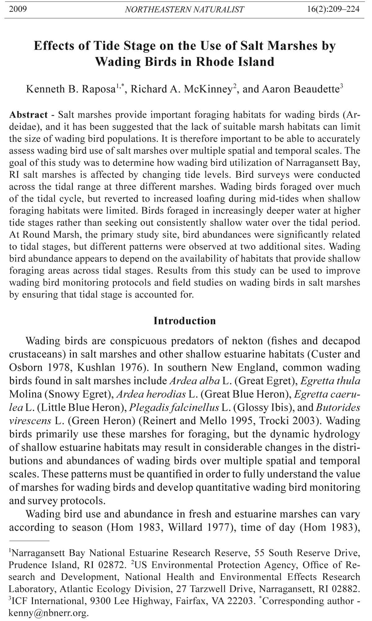
This study was primarily conducted in the Audubon Society of Rhode
Island’s Round Marsh salt marsh complex in Jamestown, RI (Fig. 1). This
21.7-ha marsh is comprised of 17.2 ha of vegetated salt marsh (79%),
Figure 1. Map of the Round Marsh study site, located in Jamestown, RI in lower
Narragansett Bay. The map shows vegetated salt marsh habitats, adjacent tidal water
habitats (i.e., tidal flats, creeks, and ditches), as well as the locations of the viewing
station and tide staff. The map is placed over an aerial photograph of the surrounding
landscape for context. The open circle in the locus map denotes the location of the
Apponaug Cove and Thatch Marsh study sites in Greenwich Bay, RI.
212 Northeastern Naturalist Vol. 16, No. 2
interspersed with a small number of tidal creeks and narrow ditches, with a
relatively large expanse of mud flats (in this study, the terms mud flat and
tidal flat are used interchangeably and are defined as unvegetated soft-bottom
habitats that are either exposed to the air or covered by shallow water at
low tide). The marsh contains a mix of plant species typical of New England
salt marshes, including Spartina alterniflora Loisel. (Smooth Cordgrass),
Spartina patens (Ait.) Muhl. (Salt Hay Grass), Distichlis spicata (L.) Greene
(Spikegrass), and Juncus gerardii Loisel. (Black Grass), while the upland
edge consists primarily of Iva frutescens L. (Hightide Bush), Panicum
virgatum L. (Switchgrass), and Phragmites australis (Cav.) Trin. ex Steud.
(Common Reed). Only a few salt marsh pools and pannes are present in
Round Marsh due to historic mosquito ditching. The marsh is surrounded by
a mix of residential and agricultural lands, is abutted by a two-lane highway
to the west of the marsh, and is connected to Narragansett Bay through a
single tidal creek flowing though a culvert under the road. Tides are semidiurnal
and averaged 0.89 m during the study period. Freshwater inputs to
the marsh are minimal and are primarily from precipitation and groundwater
flow, resulting in a mean salinity of 21 ppt. At low tide, a portion of the tidal
flats become exposed, and a small area of deep water remains directly upstream
of the culvert.
Supplemental data were collected from two additional sites in nearby
Greenwich Bay, RI (Fig. 1). Thatch Marsh is a 9.9-ha meadow marsh and is
generally similar in habitat composition to Round Marsh (i.e., a relatively
large area of vegetated salt marsh with a smaller area of creeks and tidal flats).
Apponaug Cove (6.1 ha; hereafter referred to as Apponaug) differed from
Thatch and Round Marshes in that it is primarily an intertidal, unvegetated
cove that supported only a small amount of fringing marsh vegetation. Apponaug
was specifically chosen in order to collect data from a site that differed
in the relative amount of tidal flat and salt marsh surface habitats, since it was
hypothesized that the amount of these habitats in a site would strongly affect
patterns in wading bird abundances observed throughout the tidal cycle.
Field methods
Wading birds were surveyed at Round Marsh on July 10, 12, 13, 17,
19, and 20, 2006. Surveys were conducted over an approximately six-hour
period during the course of one-half of a tidal cycle (e.g., from slack high
tide to slack low tide). All surveys were conducted during daylight hours
between 0730 and 1700 EST. Even though direction of tidal flow has
been shown to be an ineffective determinant of wading bird abundances
(Maccarone and Brzorad 2005), birds were sampled from high to low tide
on July 10, 12, and 13, and from low to high tide on July 17, 19, and 20,
2006. On each date, wading birds were surveyed from a fixed site on the
embankment off the road adjacent to the marsh (Fig. 1). Observations
were made of all visible portions of the marsh every 10 minutes over the
entire six-hour period using a 32 x 60 spotting scope or 10 x 50 binoculars.
Every 10 minutes, all wading birds observed in the marsh were identified
2009 K.B. Raposa, R.A. McKinney, and A. Beaudette 213
to species, counted, and their location in the marsh marked on a map. Additional
data recorded included the habitat where each bird was located
and its activity (derived from a list originally compiled by Kushlan [1976]
and later modified by Kelly et al. [2003]), and tidal depth (from a fixed
tide staff placed directly in front of the viewing station).
Water depths on the mud flats where birds foraged were determined
after all surveys were completed. This follow-up data collection was accomplished
by returning to the locations of each bird sighting using a
handheld Garmin GPS with coordinates derived in GIS from digital copies
of field maps. Once on location, the water depth at each location was
measured, as was the water depth at the original tidal staff. These data
were used to indirectly calculate the water depth in which each bird was
originally foraging by solving the equation:
B1 = (TS1 - TS2) + B2,
where B represents the water depth at the location of each bird, TS represents
the water depth on the tide staff, and subscripts 1 and 2 represent
the first and second recording times, respectively.
Wading bird abundance in the entire marsh, expressed as the mean number
of birds observed during a single observation period, was averaged for
5-cm tide-height intervals (e.g., from 66–70 cm, 71–75 cm, etc.) over the six
survey dates. Wading bird abundances were also determined using the same
approach for the two major habitat types (mud flat and vegetated salt marsh
surface) at Round Marsh. A best-fit nonlinear regression model was applied
to the data to determine the relationship between bird abundance and tide
level. Patterns in mean foraging depths in mud flats and bird behaviors were
also examined in relation to tidal water levels.
Wading bird surveys were conducted at Thatch Marsh on September 12,
14, and 21, and at Apponaug on September 26 and 30, 2007. On each date,
surveys were conducted over one-half of a tidal cycle as described above
for Round Marsh. At Apponaug, bird surveys were conducted every 10
minutes. At Thatch Marsh, surveys were conducted every 20 minutes due
to the need to view birds from multiple locations at this site. At both sites
during each survey, data that were collected included wading bird species,
the number of individuals, habitat used, and water depths (i.e., tide staff
height). Bird behaviors, locations, and foraging water depths were not assessed
at these sites.
The availability of foraging habitats at each site was determined using
a combination of field- and computer-mapping techniques. The area of
intertidal vegetated marsh surface habitats was digitized from 2006 color
orthophotographs (1:12,000 scale). The area of intertidal mud flat habitats
was determined by walking the perimeter of this habitat at low tide with a
handheld GPS. The area of shallow subtidal habitats (defined as subtidal
areas covered by less than approximately 28 cm of water) was determined
by measuring water depths throughout subtidal areas at low tide and then
interpolating these depths in GIS to determine the 28-cm contour.
214 Northeastern Naturalist Vol. 16, No. 2
Error estimation
At Round Marsh, every effort was made to record the location of each
bird on the maps as accurately as possible using prominent geographic features
(e.g., creeks and pools, marsh edges, etc.) in the marsh. To quantify
the error associated with mapping bird locations, one person was sent out
into the marsh to 30 randomly predetermined locations. At each location,
the person in the field crouched down, recorded their location using the
handheld GPS unit, and waited for an observer at the original viewing station
(the same observer who collected all the original data) to record their
location on a map. The GPS coordinates determined in the field were then
compared to GPS points derived from the point located on the map. This
procedure provided an error estimate that could be examined by habitat (mud
flat and marsh surface) and by distance from the viewer. The error associated
with determining locations was then used to assess the error associated with
determining wading bird foraging water depths in mud flat habitats. For 10
randomly selected points in the mud flats, eight haphazard water depths were
measured within a circle (with a radius based on the pre-determined distance
error) around each point.
Results
Round Marsh
Over the six-day sampling period, six wading bird species were observed
in Round Marsh. The Great Egret comprised 72% of all bird observations,
followed by Snowy Egret (18%), Great Blue Heron (5%), Nycticorax violaceus
L. (Yellow-crowned Night-heron, 3%), Little Blue Heron (1%), and
Nycticorax nycticorax L. (Black-crowned Night-heron, 1%). In general,
wading birds were found throughout much of Round Marsh in a variety of
habitat types, including flooded mud flats, marsh vegetation, creeks, pools,
and pannes.
Overall wading bird abundance (all species and all behaviors combined)
was closely related to tide stage in Round Marsh and was best explained with
a third-degree polynomial nonlinear regression (R2 = 0.85, F = 32.44, P less than
0.0001; Fig. 2). At the lowest tide levels, when water was concentrated in
shallow areas on the mud flats, wading bird abundance was relatively high.
As tide levels increased, bird abundance quickly dropped until water levels
became high enough to flood the vegetated marsh surface, at which time bird
abundance once again increased. At the highest tide levels, bird abundances
dropped off again.
In mud flat habitats, bird abundance was only high during the lowest
tide levels (Fig. 3). As water levels increased, bird abundance exhibited a
significant exponential decay (R2 = 0.67, F = 36.43, P < 0.0001) on the mud
flats and remained low throughout the high-tide period. In contrast, bird
abundance on the vegetated marsh surface was best explained with a secondorder
Gaussian model (R2 = 0.76, F = 33.39, P < 0.0001), with lowest bird
abundances occurring at low tide levels (when most birds were on the flats),
2009 K.B. Raposa, R.A. McKinney, and A. Beaudette 215
followed by a peak at mid-tide levels and a drop again at the highest tide
levels (Fig. 3).
Water depths in which Great and Snowy Egrets foraged on the mud
flats increased concomitantly with increasing tide levels (Fig. 4). Both species
continued foraging in the mud flats in deeper water as the tide levels
increased. However, the maximum foraging depth for Snowy Egrets was
approximately half the maximum depth for Great Egrets; consequently, on
incoming tides Snowy Egrets ceased foraging in the flats much earlier than
Great Egrets. Overall, Snowy Egrets were found foraging in water depths
that ranged from 3–23 cm, with an overall mean foraging depth of approximately
13 cm (Fig. 4). Great Egrets foraged in waters ranging from 3–44 cm
in depth, with an overall mean foraging depth of 14 cm.
Great and Snowy Egrets each exhibited seven distinct behaviors in Round
Marsh. Differences in behaviors were observed between the two species and
among the different stages of the tide. Overall, Snowy Egrets spent considerable
time actively foraging for food, displaying behaviors such as stalking,
walking slowly, and walking quickly (these three behaviors accounted for
71% of all observations. Conversely, Great Egrets were much less active
Figure 2. Mean (± 1 S.E.) numbers of wading birds observed (all habitats, species,
and behaviors combined) in relation to tide level in Round Marsh. Mean values were
derived by averaging all observations from July 10, 12, 13, 17, 19, and 20, 2006,
within 5-cm tide-height intervals (e.g., from 66–70 cm, from 71–75 cm etc.). Tide
elevations were read from a fixed tide staff near the mouth of the marsh. The elevation
of the staff was not surveyed, so tide heights are relative (e.g., the tidal pattern
from low to high tide runs from the left to right on the x axis).
216 Northeastern Naturalist Vol. 16, No. 2
and generally spent more time preening, standing and waiting, and looking
around (66% of all observations for all three behaviors combined). In
general, both species spent more time displaying foraging behaviors during
the low and high tide levels, when shallow water was present on mud flat
and marsh surface habitats, respectively. Conversely, during mid-tide levels,
individuals of both species that remained in the marsh spent relatively less
time foraging and more time preening.
Error estimation
The measurement error associated with mapping bird locations and then
returning to those same locations to measure water depths increased with
increasing distance from the viewing station. The amount of measurement
error averaged 4.5 m for distances within 100 m of the viewing station. This
error increased to an average of 9.9 m for distances between 100–200 m,
and to 32.5 m for distances between 200–300 m. However, all locations
where water depths were measured were in the shallow mudflat tidal basin
(Fig. 1), which was within 200 m of the viewing station. The mean error for
distances between 0–200 m was 8.9 m. Water depths varied very little within
this 8.9-m radius around 10 randomly selected points on the shallow tidal
Figure 3. Mean (± 1 S.E.) numbers of birds in mud flat and marsh surface habitats in
relation to tide level in Round Marsh. Mean values for each habitat were derived by
averaging all observations from July 10, 12, 13, 17, 19, and 20, 2006, within 5-cm
tide height intervals (e.g., from 66–70 cm, from 71–75 cm etc.). Tide elevations were
read from a fixed tide staff near the mouth of the marsh. Since the elevation of the
staff was not surveyed, the tide heights are relative; the tidal pattern from low to high
tide runs from left to right on the x axis.
2009 K.B. Raposa, R.A. McKinney, and A. Beaudette 217
flats. Mean error in water depths within this zone was only 1.8 cm due to
the uniform mud flat bottom, illustrating the relative accuracy of the depth
measurements estimated in this study.
Inter-marsh comparisons
Patterns in wading bird abundances differed at both Thatch Marsh and
Apponaug compared to Round Marsh (Fig. 5). Bird abundance at Thatch
Marsh exhibited two distinct peaks, but these occurred at somewhat different
stages of the tide than at Round Marsh. At Thatch Marsh, bird
abundance peaked at the highest tide levels and a secondary peak occurred
at water levels slightly above slack low tide. Unlike the pattern at
Round Marsh, bird abundance fell during slack low tide. Bird abundance
at Thatch Marsh was best explained with a third-degree polynomial nonlinear
regression (R2 = 0.66, F = 10.24, P = 0.0005). At Apponaug, bird
abundance was highest at slack low tide, quickly dropped off at higher tide
levels, and was best explained with a logarithmic regression (R2 = 0.69,
F = 61.65, P < 0.0001).
The area of foraging habitats that was available at different tide stages
also differed among the three study sites (Fig. 6). Shallow subtidal areas
(mud flats at low tide that are covered by less than 28 cm of water) were
common at both Round Marsh and Apponaug, but relatively scarce at Thatch
Figure 4. Mean (± 1 S.E.) water depths in which Great and Snowy Egrets were
actively foraging at varying tide levels in Round Marsh tidal flat habitats. Mean
numbers for each species were derived by averaging all observations from July 10,
12, 13, 17, 19, and 20, 2006 within 5-cm tide height intervals (e.g., from 66–70 cm,
from 71–75 cm etc.).
218 Northeastern Naturalist Vol. 16, No. 2
Marsh. Intertidal mud flats were present at all three sites, but were most common
at Apponaug. In contrast, vegetated salt marsh habitats were common at
both Round and Thatch Marshes, but were virtually absent from Apponaug.
Discussion
Six species of wading birds were found in salt marshes in this study
and, except for the absence of Glossy Ibis, the composition of the wading
bird community was similar to those reported from other southern New
England marshes (Clark et al. 1984, Reinert and Mello 1995, Trocki 2003).
However, there were typically fewer than a dozen birds in each of the three
marshes in this study at any given time. After adjusting for the area of each
site, the maximum densities observed were 2.6 birds ha-1 at Apponaug,
1.0 birds ha-1 at Thatch Marsh, and 0.6 birds ha-1 at Round Marsh. These
maximum densities are smaller than those reported in other studies at lower
latitudes (e.g., Gawlik 2002, Velasquez 1992). Because wading bird densities
in New England can be so small, it is important to understand how
marsh use varies over small-scale time periods since a difference in only a
small number of birds can disproportionately alter the perceived value of
a marsh for wading birds.
Figure 5. Modeled bird abundances from the three study sites. Models were derived
using best-fit regressions to actual bird abundances over tidal cycles at each site. To
account for differences in relative tide staff levels at each site, modeled data were
normalized according to the height above the low-tide staff level at each site. Bird
numbers were not adjusted for site area (e.g., not converted to density) to ensure that
models overlaid each other to facilitate visual comparisons.
2009 K.B. Raposa, R.A. McKinney, and A. Beaudette 219
Wading birds in Round Marsh exhibited patterns in abundances,
behaviors, and foraging that were related to water depths associated with the
diurnal tidal cycle. The behaviors displayed by Great and Snowy Egrets in
this study were similar to those observed in other marshes in Narragansett
Bay, RI (Trocki 2003). The observation that Snowy Egrets spent relatively
more time actively foraging compared to Great Egrets was also consistent
with studies from other regions (e.g., DuBowy 1996, Kushlan 1976). In this
study, both egret species spent the majority of their time utilizing various
foraging behaviors while using Round Marsh. The exception occurred during
intermediate tidal stages (i.e., mid-tide) when tidal water levels were
relatively deep over the unvegetated flats but had not yet flooded the emergent
marsh surface. During this period, shallow-water foraging habitat was
not readily available and birds either left the marsh completely or remained
behind and displayed loafing behaviors (e.g., preening or standing and waiting).
Similar results were observed by both Austin (1996) and Sawara et al.
(1990), who found that the feeding activities of Great Blue and Grey Herons
were restricted by the level of the tide.
The water depths in which egrets foraged in this study fall within the general
range documented for both species in other areas (Gawlik 2002, Hom
1983, Powell 1987, Willard 1977). Surprisingly, neither Great nor Snowy
Egrets appeared to actively seek out the shallowest areas for foraging as
Figure 6. Total area of three foraging habitat types at the three study sites. Shallow
subtidal habitats are areas at low tide covered by less than 28 cm of water. Intertidal
marsh habitats are areas on the marsh surface that are covered by rooted emergent
vegetation. Intertidal flat habitats are areas without rooted emergent vegetation that
are located vertically between the other two habitats.
220 Northeastern Naturalist Vol. 16, No. 2
has been reported elsewhere (Gawlik 2002). Instead, both species foraged
in water that became continually deeper as tide levels rose in Round Marsh.
This pattern makes sense for Great Egrets, which generally limit their movements
while foraging and can forage more successfully in deeper water than
smaller species (Powell 1987). Conversely, Snowy Egrets spent relatively
more time walking while foraging, but this was apparently not in an attempt
to find the shallowest areas in which to forage.
At any given time in Round Marsh, birds may simply have had limited
choices in terms of foraging water depths because of the uniform topography
of the tidal flats (as evidenced by the small variability in water depth across
the flats). Coupled with the presence of steep-sided, erosional marsh banks,
birds were largely relegated to foraging in deeper water on the flats as tide
levels rose. In other marshes that have gradually sloping substrates that
grade into depositional marsh banks, birds have the choice of following the
shallowest leading edges of the water as it floods or ebbs across the flats. At
these sites, birds can therefore forage in consistently shallow water even as
tidal levels change. Ultimately, the pattern of increasing foraging depth with
rising tide levels observed in this study may not be generically applied to all
marshes; patterns may vary depending on marsh geomorphology, slope, and
habitat configuration. The pattern observed at Round Marsh exemplifies the
“step-function” scenario described by Powell (1987), where foraging habitat
is accessible during low tide on shallow flats and at high tide on the flooded
marsh surface, but not necessarily during mid-tides when waters are deep on
the flats and the marsh is dry.
Patterns in overall bird abundances in Round Marsh mirrored those
observed for behavior and were again related to the amount of shallow
habitats that were available to birds at any given point in time due to tidal
changes. Higher bird abundances occurred when shallow water covered
either the mud flats (during slack low water) or the marsh surface; bird
abundances dropped when the water was too deep to forage on the flats
or the marsh surface (during slack high water). Other research has consistently
found a link between water levels and wading bird abundances. For
example, Matsunaga (2000) found that the numbers of herons increased at
lower tide levels and differed between spring and neap tide levels. Abundances
were higher during spring low tides when water levels were lower
and prey densities were presumably higher. Maccarone and Brzorad (2005)
found that tide level was a significant predictor for abundances of Snowy
Egret, Great Egret, and Glossy Ibis. In the Everglades, water level had the
greatest effect on wading bird abundances and distribution (Bancroft et al.
2002). At multiple marshes in Narragansett Bay, Trocki and Paton (2006)
found that bird abundances did not significantly differ between low and
high tides. Surveys at Round Marsh support this conclusion but also illustrate
that this is a simplified picture; abundance patterns are much more
complex over the course of the tides and are clearly a reflection of differences
in the availability of shallow foraging habitats. High-resolution
2009 K.B. Raposa, R.A. McKinney, and A. Beaudette 221
temporal data from this study provide a picture of the variability of wading
bird abundances in New England salt marshes in relation to rapidly changing
water levels associated with the diurnal tides.
Results from Thatch Marsh and Apponaug indicate that the temporal
pattern in bird abundances observed at Round Marsh is not generic, thus
suggesting that the relationship between bird abundances and tide stage are
to some degree site-specific depending on the foraging habitats available to
birds at a site. The two additional sites in this study were specifically chosen
to illustrate two different extremes in the relative amounts of different
types of foraging habitats available to wading birds. For example, the only
time birds were abundant at Apponaug was near slack low tide when relatively
large areas of shallow subtidal habitats were available for foraging.
A second peak in abundance did not occur at Apponaug due to the virtual
absence of higher-elevation vegetated salt marsh habitat. Consequently,
bird abundances decreased rapidly as tide levels increased above slack
low and remained at or near zero throughout the mid- and high-tide stages.
The same pattern did not occur at Thatch or Round Marsh, both of which
contained sizable areas of vegetated salt marsh where birds could forage at
higher tides.
Abundance patterns at Thatch Marsh were similar to those at Round
Marsh, although there was a shift in the timing of bird abundance peaks
between the two sites. At Thatch Marsh, there was a dip in bird abundance
at slack low tide and a subsequent peak when water levels rose slightly.
This was probably due to a minimal amount of shallow subtidal habitat in
which birds could forage at slack low tide in contrast to Round Marsh. It
is possible that some birds left Thatch Marsh at slack low tide and moved
to nearby Apponaug (only 0.8 km away) to forage on the newly available
shallow subtidal flats at that site. The overall inverse pattern in bird
abundances seen at Thatch compared to Round Marsh is difficult to explain
with such limited data and, in general, could be due to differences in
tide heights among survey days or differences in the relative elevations/
topography of mud flat and marsh habitats. For example, if mud flats in
Thatch Marsh sit at a higher elevation than at Round Marsh, then the flats
will flood relatively later at Thatch. Prohibitively deep water over the flats
and the consequent dip in bird abundance would therefore also occur later
in the tidal cycle and result in the pattern shown in Figure 5. However, this
explanation remains speculative, and the phase-shift in abundance could
be due to many interrelated factors. Regardless of the factors responsible,
the main point is that the tidal pattern in bird abundance differed between
Thatch and Round Marshes.
The fact that patterns in wading bird abundances can vary among
different sites has important ramifications for monitoring programs and
study design. For example, it may not be appropriate to sample all sites at
the same tide stage if the project goal is to quantitatively compare birds
among multiple sites. Hypothetically, if birds had been surveyed at the
222 Northeastern Naturalist Vol. 16, No. 2
three sites in this study only at slack low tide, the data would suggest that
Apponaug and Round Marsh were relatively more valuable than Thatch
Marsh for wading birds. However, if all available data were averaged
across the entire tidal cycle, a different conclusion emerges. Mean bird
abundances over the tidal range at Round and Thatch Marshes were 5.5
and 5.0 birds respectively, while at Apponaug it was 3.1 birds, indicating
that conclusions drawn from sampling only at slack low water would be
misleading. A further problem is that tidal water level, and therefore wading
bird abundances, can change rapidly. Based on data from this study,
a 10-cm change in water depth can occur in as little as one hour in Narragansett
Bay, and substantial changes in bird abundances were observed
over this same period. Therefore, a bird survey conducted at a marsh at
slack low tide might yield substantially different results than if the same
survey was conducted only an hour earlier or later.
An alternate method to surveying birds at only one tide stage would
involve conducting frequent surveys of birds in a marsh over the entire
tidal cycle and then replicating these tidal surveys over time to account for
other factors such as weather and tidal phases (i.e., spring vs. neap). This
approach would obviously entail much more work on a given day (e.g.,
over six hours compared to a brief survey at a single tide level). However,
it is also possible that sampling could be conducted over fewer days since
much more data would be collected within each tidal survey. If birds are
to be surveyed at a single time stage, preliminary tidal surveys could also
be conducted to identify the timing of abundance peaks in order to help
guide further sampling. The tidal-survey approach should provide more
meaningful data than sampling at a single tidal stage, but the sampling
methodologies employed will depend on the specific goals of each research
or monitoring program.
The results of this study provide a better understanding of how wading
birds use New England salt marshes over the tidal cycle. However, this
study is limited in that data were only collected from three sites and only
comprehensively from Round Marsh. To corroborate the results found here,
similar sampling should be conducted at additional marshes with a variety of
habitat configurations to better understand how different patterns in wading
bird abundances across the tides are related to specific habitat mosaics in a
marsh. The three marshes in this study were purposefully chosen to reflect
differences in the ratios of only three general habitat types: shallow subtidal
flats, intertidal flats, and vegetated marshes. The relative effects of additional
habitat types, such as marsh pools that can provide shallow foraging habitat
during all tidal stages, should also be investigated. This study provides timeseries
data of wading bird abundances over the tidal cycle and demonstrates
that tide-related patterns in bird abundances can vary dramatically among
marshes. The results provide a better understanding of how these birds use
New England salt marshes for foraging and should lead to more accurate and
efficient planning of survey and monitoring programs in this region.
2009 K.B. Raposa, R.A. McKinney, and A. Beaudette 223
Acknowledgments
We would like to thank Tom Kutcher for assistance with field planning and estimating
sighting errors, and Rachel Dapp, Felicia Olmeta, and Andrew McKinney for
help with wading bird surveys. Access to Round Marsh was granted by the Audubon
Society of Rhode Island. This research was supported in part by NOAA - Estuarine
Reserves Division Grant # NA05NOS4201120 and the State of Rhode Island, Department
of Environmental Management, Division of Water Resources. Mention of trade
names or commercial products does not constitute endorsement or recommendation.
Although the research described in this article has been funded in part by the US
Environmental Protection Agency, it has not been subjected to Agency-level review.
Therefore, it does not necessarily reflect the views of the Agency. This paper is contribution
number AED-08-016 of the Office of Research and Development, National
Health and Environmental Effects Research Laboratory, Atlantic Ecology Division.
Literature Cited
Adamowicz, S.C., and C.T. Roman. 2005. New England salt marsh pools: A quantitative
analysis of geomorphic and geographic features. Wetlands 25:279–288.
Austin, H.M. 1996. Observations on daylight feeding periodicities of wading birds
(Ardeidae) in Sarah’s Creek, York River, Virginia. The Journal of the Elisha
Mitchell Scientific Society 111:137–145.
Bancroft, G.T., D.E. Gawlik, and K. Rutchey. 2002. Distribution of wading birds
relative to vegetation and water depths in the northern Everglades of Florida,
USA. Waterbirds 25:265–391.
Clark, J.A., B.A. Harrington, T. Hruby, and F.E. Wasserman. 1984. The effect of
ditching for mosquito control on salt marsh use by birds in Rowley, Massachusetts.
Journal of Field Ornithology 55:160–180.
Custer, T.W., and R.G. Osborn. 1978. Feeding-habitat use by colonially breeding
herons, egrets, and ibises in North Carolina. The Auk 95:733–743.
DuBowy, P. 1996. Effects of water levels and weather on wintering herons and
egrets. The Southwestern Naturalist 41:341–347.
Ferren, R.L., and J.E. Myers. 1998. Rhode Island’s Maritime Nesting Birds. Rhode
Island Department of Environmental Management, Division of Fish and Wildlife,
West Kingston, RI. 222 pp.
Gawlik, D.E. 2002. The effects of prey availability on the numerical response of
wading birds. Ecological Monographs 72:329–346.
Hom, C.W. 1983. Foraging ecology of herons in a southern San Francisco Bay salt
marsh. Colonial Waterbirds 6:37–44.
Kelly, J.F., D.E. Gawlik, and D.K. Kieckbusch. 2003. An updated account of wading
bird foraging behavior. Wilson Bulletin 115:105–107.
Kushlan, J.A. 1976. Feeding behavior of North American herons. Auk 93:86–94.
Kushlan, J.A. 1981. Resource-use strategies of wading birds. Wilson Bulletin
93:145–163.
Maccarone, A.D., and J.N. Brzorad. 2005. Foraging microhabitat selection by
wading birds in a tidal estuary, with implications for conservation. Waterbirds
28:383–391.
Matsunaga, K. 2000. Effects of tidal cycle on the feeding activity and behavior
of Grey Herons in a tidal flat in Notsuke Bay, northern Japan. Waterbirds
23:226–235.
224 Northeastern Naturalist Vol. 16, No. 2
Powell, G.V.N. 1987. Habitat use by wading birds in a subtropical estuary: Implications
of hydrography. The Auk 104:740–749.
Reinert, S.E., and M.J. Mello. 1995. Avian community structure and habitat use in a
southern New England estuary. Wetlands 15:9–19.
Roman, C.T., N. Jaworski, F.T. Short, S. Findlay, and R.S. Warren. 2000. Estuaries
of the northeastern United States: Habitat and land-use signatures. Estuaries
23:743–764.
Rozas, L.P. 1995. Hydroperiod and its influence on nekton use of the salt marsh: A
pulsing ecosystem. Estuaries 18:579–590.
Sawara, Y., N. Azuma, K. Hino, K. Fukui, G. Demachi, and M. Sakuyama. 1990.
Feeding activity of Grey Heron Ardea cinerea, in tidal and non-tidal environments.
Japanese Journal of Ornithology 39:45–52.
Strong, A.M., G.T. Bancroft, and S.D. Jewell. 1997. Hydrological constraints on
Tricolored Heron and Snowy Egret resource use. The Condor 99:894–905.
Trocki, C.L. 2003. Patterns of salt marsh and farmland use by wading birds in southern
Rhode Island. M.Sc. Thesis. University of Rhode Island, Kingston, RI. 97 pp.
Trocki, C.L., and P.W.C. Paton. 2006. Assessing habitat selection by foraging egrets
in salt marshes at multiple spatial scales. Wetlands 26:307–312.
Velasquez, C.R. 1992. Managing artificial saltpans as a waterbird habitat: Species’
responses to water-level manipulation. Colonial Waterbirds 15:43–55.
Willard, D.E. 1977. The feeding ecology and behavior of five species of herons in
southeastern New Jersey. The Condor 79:462–470.