2009 NORTHEASTERN NATURALIST 16(4):577–584
Effects of Antenna Orientation and Vegetation on Global
Positioning System Telemetry Collar Performance
Jerrold L. Belant*
Abstract - Use of global positioning system (GPS) collars to improve our understanding
of bear movements and habitat use has increased markedly in the last 10
years. Habitat use has been better defined using this technology, but variation in
acquisition rates across covertypes and with varying antenna orientation could bias
results. I assessed the effects of vegetative habitat characteristics and antenna orientation
on percent of successful fixes and 3-dimensional (3D) fixes for GPS collars
designed for Ursus americanus (American Black Bear) in Michigan during April–
July, 2001–2002. I placed collars in 5 habitats with varying tree density, diameter,
and canopy cover and also in an unobstructed area with antennas oriented 0–90º from
horizontal. Basal area was the only habitat parameter measured that influenced fix
success; the correlation was negative. Percent of successful locations obtained in the
open area decreased as antenna orientation increased away from the vertical position.
Habitat characteristics and antenna orientation appeared to influence the percent
of total fixes and 3D fixes obtained, which could have adverse effects on accuracy.
Thus, bear or other wildlife use of certain covertypes and behavior (e.g., sleeping)
can reduce GPS collar acquisition rates. Variation in acquisition rates among covertypes
and antenna orientation warrants consideration for development of correction
factors based on habitats encountered and animal behavior.
Introduction
Radiotelemetry has been used to study free-ranging wildlife for more
than 40 years (Rodgers 2001). Numerous technological advances have
resulted in several satellite systems, including global positioning system
(GPS)-based telemetry, which became fully operational in 1993 (Rodgers
et al. 1996). Global positioning system collars are now frequently used in
resource selection and movement studies of bears and other species (Arthur
and Schwartz 1999, Belant and Follmann 2002, Merrill et al. 1998).
Accuracy of GPS receivers was reduced initially because of signal
degradation, referred to as “selective availability”, enacted by the US Department
of Defense. Horizontal position estimates were typically within 100
m 95% of the time (Wells 1986). Differential correction was employed frequently
to reduce error typically to less than 10 m (Moen et al. 1997). Selective availability
was discontinued on 2 May 2000 (Lawler 2000), which resulted in 95%
of position estimates within 10 m of actual location, similar to differentially
corrected data (Moen et al. 1997, Rempel and Rodgers 1997). Although GPS
technology has provided additional opportunities for biologists conducting
field studies, several shortcomings and biases of this system exist (D’Eon and
*Department of Wildlife and Fisheries, Mississippi State University, Box 9690, Mississippi
State, MS 39762; jbelant@cfr.msstate.edu.
578 Northeastern Naturalist Vol. 16, No. 4
Delparte 2005, D’Eon et al. 2002, Frair et al. 2004, Hansen and Riggs 2008).
Terrain and vegetative characteristics have reduced the proportion of successful
fixes (Rempel et al. 1995, Schwartz and Arthur 1999). Also, bear behavior
(e.g., lying down) could reduce location acquisition rate by changing GPS antenna
orientation (Belant and Follmann 2002, Moen et al. 1996, Obbard et al.
1998). My objectives were to assess the effects of vegetation characteristics
and collar orientation on GPS collar performance.
Methods
I conducted tests at Pictured Rocks National Lakeshore (PRNL), a unit
of the National Park Service located in the Upper Peninsula of Michigan
(46º27'N, 86º33'W). Pictured Rocks National Lakeshore is predominantly
northern hardwood forests comprised primarily of Acer saccharum Marsh.
(Sugar Maple) and Fagus grandifolia Ehrh. (American Beech). Most hardwood
stands were clearcut in the early 1900s (Frederick et al. 1977). Other
habitats include lowland conifer, lowland shrub, and upland Pinus banksiana
Lamb. (Jack Pine) and mixed pine (Pinus spp.).
I tested GPS collars (Model G2000; Advanced Telemetry Systems, Inc.
[ATS], Isanti, MN) designed for use on Ursus americanus Pallas (American
Black Bear) during April–July, 2001–2002. Completed collar package
weight was 1100 g and included a very high frequency (VHF) transmitter.
Maximum fix duration was 96 sec, and period between almanac fixes was
48 h. I programmed collars to attempt locations every 2 h during 2001 and
every 30 min during 2002.
I evaluated the accuracy of GPS collars at one site by plotting locations
relative to the known location. The known location was derived using a
Trimble GPS Pathfinder Pro XL (Trimble Navigation Ltd., Sunnyvale, CA)
with ± cm accuracy. I calculated the distance and angle of each fix to the
actual location and used Rayleigh’s test to assess if the angular distribution
of locations were random (Zar 1984). To assess effects of orientation, I
monitored fix rates for 5 collars with GPS antennae oriented 90, 67, 45, 23,
and 0º from horizontal and compared percent successful fixes and percent of
3-dimensional (3D) fixes. Collars were placed in a level open area to minimize
obscuration.
I assessed effects of vegetative cover on percent successful fixes by placing
3 GPS collars in one stand each of 5 habitats representative of PRNL:
1) uneven-age northern hardwood forest, 2) immature northern hardwood
forest, 3) spruce (Picea spp.) forest, 4) mixed hardwood and conifer forest,
and 5) alder (Alnus sp.) lowland. Collars were placed at ground level on
sites with low topographic relief (<5 m). Antennae were oriented 90º from
horizontal; total number of attempted fixes/site ranged from 93–348.
I measured stem density and canopy characteristics at each site, using
methods similar to Schwartz and Arthur (1999). A GPS collar was placed
with the antenna orientated 90o from horizontal at ground level in each
habitat. To assess effects of antenna orientation in vegetated habitats, I also
2009 J.L. Belant 579
placed GPS collars with antennas oriented 30º and 60º from horizontal in
spruce and alder habitats. Stem density was assessed by measuring all trees
>2.5 cm diameter at breast height (dbh) within a 3-m radius of the GPS unit.
Basal area (cm2/m2) was calculated from stems >2.5 cm. Stems less than 2.5 cm dbh
also were counted within 3 m of the GPS unit. Canopy height was measured
using a clinometer. I estimated canopy closure using a spherical densiometer
(Lemmons 1956) at the collar location and 3 m from the collar in the
4 cardinal directions. Four imaginary dots within each of 24 quarter-inch
squares were used to estimate the proportion of dots obscured by canopy.
The number of obscured dots was divided by 96 to determine percent and
averaged for the 5 locations to estimate mean canopy closure. I used correlation
analysis (Zar 1984) to evaluate associations between fix rates and
vegetative characteristics.
Results
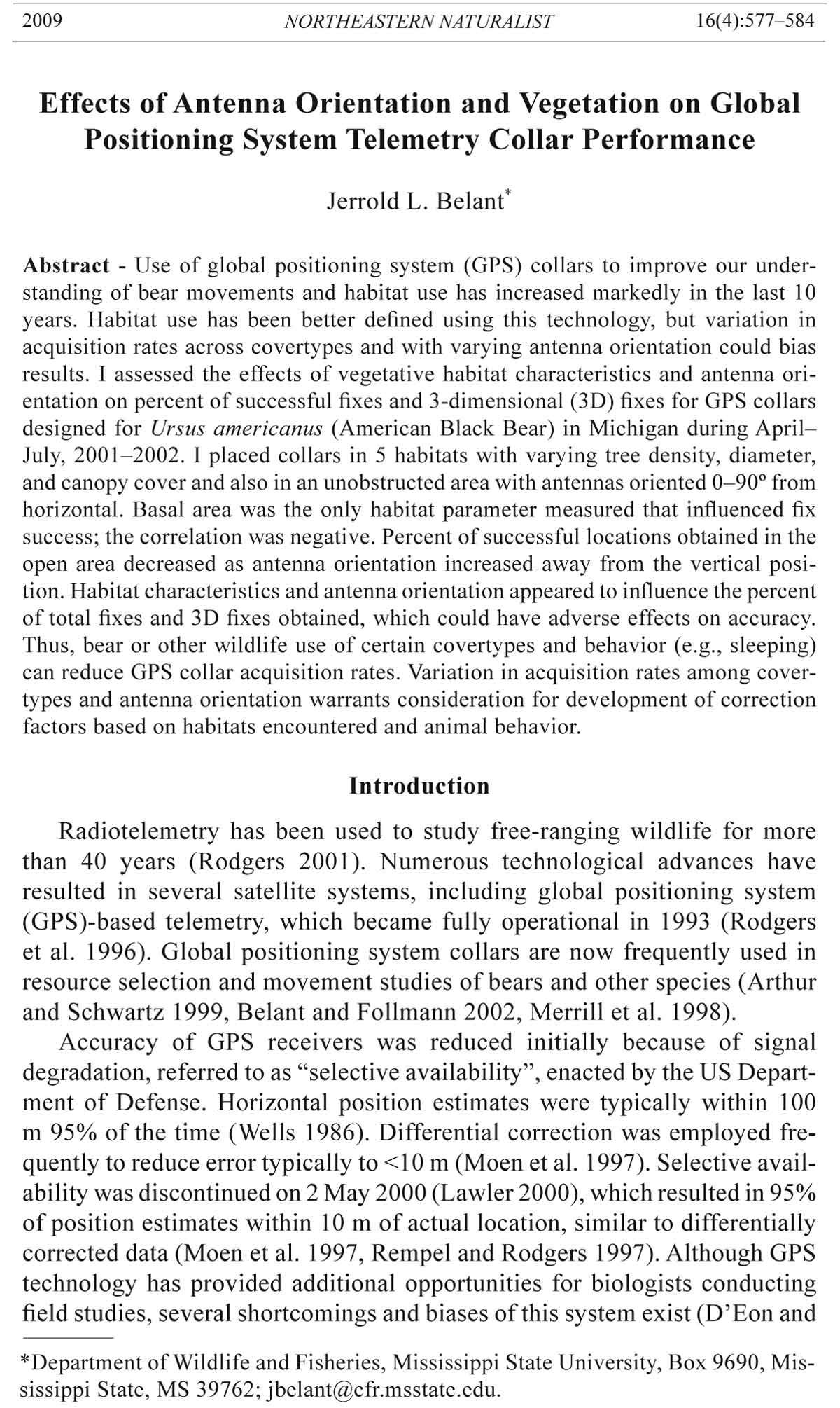
Accuracy of fixes obtained from the known site was high (Fig. 1). Fiftyone
percent and 87% of fixes were within 4 and 10 m, respectively, of the
actual location. Median error was 5.8 m, and greatest error was 51 m. Angular
distribution of locations was not different from random (z = 2.14, df =
189, P > 0.05).
Percent fix rate and percent of 3D locations decreased when the GPS
antenna was less than 45° from horizontal in open habitat (Fig. 2). Similarly, fix rate
and percent of 3D fixes declined when the GPS antenna was oriented less than 90°
and less than 60° in spruce and alder habitats, respectively (Fig. 3). Percent successful
fixes dropped 20-fold from 60° to 30° antenna orientation in alder habitat
and declined to 0% success when the antenna was 30° from horizontal in
spruce habitat.
Percent successful fixes ranged from 11% in spruce habitat to 93% in
the immature hardwood habitat (Table 1). Percent 3D fixes ranged from to
54% in spruce to 85% in the immature hardwood. Percent successful fixes
declined with basal area (r = -0.85, df = 5, P = 0.070), but not with percent
overstory closure, overstory height, or stem density (r = -0.07 to 0.63, df =
5, P = 0.254 to 0.906). Percent of 3D fixes declined similarly with basal area
(r = -0.88, df = 5, P = 0.047), but not percent overstory closure, overstory
height, or stem density (r = -0.48 to 0.42, df = 5, P = 0.418 to 0.760).
Table 1. Characteristics of GPS collar performance in five habitats, Pictured Rocks National
Lakeshore, Upper Peninsula of Michigan, May–July, 2001–2002. Pf = potential fixes (n), Sf =
% successful fixes, 3D = % 3D fixes, Oc = overstory closure (SD), Oh = overstory height (m),
S = stems (>2.5 cm)/m2, Sd = mean (SD) stem (>2.5 cm) diameter, Ba = basal area (cm2/m2),
and Ts = total stems /m2.
Vegetation type Pf Sf 3D Oc Oh S Sd Ba Ts
Hardwood (uneven-age) 112 74 67 97.5 (2.7) 20.7 0.46 9.1 (11.1) 30.0 1.06
Hardwood (immature) 142 93 85 97.2 (1.8) 12.6 0.32 5.9 (2.1) 8.7 0.99
Spruce 119 11 54 98.9 (1.5) 13.4 0.21 16.1 (3.8) 42.7 0.21
Mixed 107 80 78 96.3 (1.9) 14.3 0.18 14.2 (5.9) 28.4 0.46
Alder 93 78 73 93.8 (3.7) 4.6 0.64 5.8 (1.8) 16.9 1.59
580 Northeastern Naturalist Vol. 16, No. 4
Discussion
Accuracy of the GPS unit in open habitat with 90º antenna orientation
met expectations with removal of selective availability. Accuracy in this
study was similar to studies using differentially corrected data (Moen et
al. 1997, Rempel and Rodgers 1997). With selective availability disabled,
Figure 1. Accuracy (a) of GPS locations relative to actual location and scattergram
(b) of locations and distance from actual location (center), Pictured Rocks National
Lakeshore, 27 April–9 May, 2001.
2009 J.L. Belant 581
accuracy is less than 20 m and less than 10 m 95% of the time for nondifferentially and differentially
corrected data, respectively (Wells 1986). In this study, 87% of
Figure 2. Percent of GPS fixes that were successful (stippled bars) and, of those, the percent
that were 3D fixes (solid bars) for 5 GPS collars (one at each angle from horizontal)
in open habitat by degree from horizontal, Pictured Rocks National Lakeshore, 6–14
July, 2002.
Figure 3. Percent of GPS fixes that were successful and,of those, the percent that were
3D fixes in spruce (striped bars) and alder (stippled bars) habitats for 3 GPS collars by
degree from horizontal, Pictured Rocks National Lakeshore, 9–17 July, 2002.
582 Northeastern Naturalist Vol. 16, No. 4
fixes were <10 m from the actual location, similar to differentially corrected
data. Using collars from a different manufacturer, 26–38% of locations
without differential correction were within 40 m of the actual location when
selective availability was enabled (Schwartz and Arthur 1999). Median error
in this study (5.8 m) was greater than that determined by Wells (1986)
(3.1 m) for differentially corrected data with selective availability disabled.
With selective availability disabled, differential correction is likely unnecessary
for many wildlife applications.
It is well known that GPS antenna orientation can affect fix rate
(Tomkiewicz 1996). However, few studies have attempted to address
or quantify the effects of antenna orientation on GPS collar acquisition
rates (Jiang et al. 2008). Telemetry manufacturers stress the importance
of attaching collars such that the GPS antenna is oriented as close to 90º
from horizontal as possible. Therefore, certain bear behaviors (e.g., resting,
nursing young) that reduce optimal antenna orientation will likely
decrease the number of successful fixes obtained (Belant and Follmann
2002, D’Eon et al. 2002). In addition, a higher proportion of successful
fixes will be 2-dimensional, which are less accurate than 3D fixes (Rodgers
2001, Schwartz and Arthur 1999).
Habitat characteristics have been demonstrated to reduce success of GPS
fixes (D’Eon et al. 2002, Obbard et al. 1998, Schwartz and Arthur 1999). I
only conducted tests during the leaf-on period to obtain a conservative estimate
of fix acquisition rates and because it was representative of the majority
of the non-denning period for American Black Bears. In this study, basal
area was the only parameter that adversely affected fix success. In contrast,
canopy cover has frequently been a significant factor for fix success in other
studies (e.g., D’Eon et al. 2002, Sager-Fradkin et al. 2007, Schwartz and
Arthur 1999). Canopy cover was consistently high, thus its effects on GPS
fix success may have been undetectable in this study .
In this study, percent of successful fixes appeared to decrease when
orientation and habitat effects were combined. As the angle of GPS antenna
orientation approached a horizontal position, the percent of successful GPS
fixes and percent of 3D locations declined more rapidly in vegetated areas
than in an open area. D’Eon et al. (2002) found a significant interaction
between terrain and canopy closure. Sager-Fradkin et al. (2007) noted GPS
success rate was influenced by canopy cover, satellite view, and elevation.
Thus, multiple factors can interact to influence GPS fix success, which will
vary among study areas.
Inability of GPS units to receive satellite transmissions in areas of high
tree basal area or when GPS antennae are oriented away from vertical may
affect home range and habitat use estimates. Terrain can also interact with
habitat to reduce fix success (D’Eon et al. 2002, Jiang et al. 2008). Ability
to determine bear habitat use during certain activities such as sleeping
(e.g., daytime rest sites) also may be compromised. Several possibilities
exist to reduce this error. Samuel and Kenow (1992) recommended select2009
J.L. Belant 583
ing the most likely habitat within the estimated error. Habitats with small
patch size may be missed, however (DeBruyn 1997). Belant and Follmann
(2002) suggested using locations as a means to define isopleths only and
assessing resource selection using all habitats within the isopleth relative
to other areas as a means to reduce this bias. Other designs to address error
and biases have been proposed including weighting factors based on
habitat features and animal behavior (Garton et al. 2001, Hebblewhite et al.
2007, Jiang et al. 2008, Sager-Fradkin et al. 2007). These designs typically
involve site-specific assessments of overstory vegetation, topography, and
species investigated (e.g., activity patterns and antenna orientation) to assess
bias and develop correction factors. Although GPS technology has greatly
enhanced home-range and resource selection studies, additional research to
improve data analyses and understanding interactions of factors affecting fix
success is required.
Acknowledgments
L. Anderson, N. Lapinski, and K. Stanley assisted with data collection. D. Licht
(NPS) and C. Kochanny (ATS) provided GPS transmitters used in 2001 and 2002,
respectively. Funding was provided by the NPS Midwest Regional Office, NPS Fee
Demonstration Program, and Pictured Rocks National Lakeshore.
Literature Cited
Arthur, S.M., and C.C. Schwartz. 1999. Effects of sample size on precision and accuracy
of Brown Bear home ranges. Ursus 11:139–148.
Belant, J.L., and E.H. Follmann. 2002. Sampling considerations for Black and
Brown Bear home range and habitat use. Ursus 13:299–315.
DeBruyn, T.D. 1997. Habitat use, food habits, and population characteristics of
female Black Bears in the central Upper Peninsula of Michigan: A geographic
information system approach. Ph.D. Dissertation. Michigan Technological University,
Houghton, MI. 127 pp.
D’Eon, R.G., and D. Delparte. 2005. Effect of radio-collar position and orientation
on GPS radio-collar performance, and the implications of PDOP in data screening.
Journal of Applied Ecology 42:383–388.
D’Eon, R.G., R. Serrouya, G. Smith, and C.O. Kochanny. 2002. GPS radiotelemetry
error and bias in mountainous terrain. Wildlife Society Bulletin 30:430–439.
Frederick, D.J., L. Rakestraw, C.R. Eder, and R.A. VanDyke. 1977. Original forest
vegetation of Pictured Rocks National Lakeshore and a comparison with present
condition. Michigan Academician 9:433–443.
Friar, J.L., S.E. Nielsen, E.H. Merrill, S.R. Lele, M.S. Boyce, R.H.M. Munro, G.B.
Stenhouse, and H.L. Beyer. 2004. Removing GPS collar bias in habitat selection
studies. Journal of Applied Ecology 41:201–212.
Garton, E.O., M.J. Wisdom, F.A. Leban, and B.K. Johnson. 2001. Experimental
design in radiotelemetry studies. Pp 15–42, In J.J. Millspaugh and J.M. Marzluff
(Eds.). Radio-tracking and Animal Populations. Academic Press, San Diego, CA.
474 pp.
Hansen, M.C., and R.A. Riggs. 2008. Accuracy, precision, and observation rates of
global positioning system telemetry collars. Journal of Wildlife Management
72:518–526.
584 Northeastern Naturalist Vol. 16, No. 4
Hebblewhite, M., M. Percy, and E.H. Merrill. 2007. Are all global positioning system
collars created equal? Correcting habitat-induced bias using three brands in the
central Canadian Rockies. Journal of Wildlife Management 71:2026–2032.
Jiang, Z., M. Sugita, M. Kitahara, S. Takatsuki, T. Goto, and Y. Yoshida. 2008. Effects
of habitat feature, antenna position, movement, and fix interval on GPS
radio collar performance in Mount Fuji, central Japan. Ecological Research
23:581–588.
Lawler, A. 2000. Scientists gain access to sharper GPS signal. Science 288:783.
Lemmons, P.E. 1956. A spherical densiometer for estimating overstory density. Forestry
Science 2:314–320.
Merrill, S.B., L.G. Adams, M.E. Nelson, and L.D. Mech. 1998. Testing releasable
GPS collars on Wolves and White-tailed Deer. Wildlife Society Bulletin
26:830–835.
Moen, R.A., J. Pastor, and Y. Cohen. 1996. Effects of behavior and canopy condition
on GPS collar performance. Journal of Wildlife Management 60:659–668.
Moen, R.A., J. Pastor, Y. Cohen, and C.C. Schwartz. 1997. Accuracy of GPS telemetry
collar locations with differential correction. Journal of Wildlife Management
61:530–539.
Obbard, M.E., B.A. Pond, and A. Perera. 1998. Preliminary evaluation of GPS
collars for analysis of habitat use and activity patterns of Black Bears. Ursus
10:209–217.
Rempel, R.S., and A.R. Rodgers. 1997. Effects of differential correction on accuracy
of a GPS animal location system. Journal of Wildlife Management 61:525–530.
Rempel, R.S., A.R. Rodgers, and K. Abraham. 1995. Performance of a GPS animal
location system under boreal forest canopy. Journal of Wildlife Management
59:543–551.
Rodgers, A.R. 2001. Recent telemetry technology. Pp. 79–121, In J.J. Millspaugh,
and J.M. Marzloff (Eds.). Radio-tracking and Animal Populations. Academic
Press, San Diego, CA. 474 pp.
Rodgers, A.R., R.S. Rempel, and K.F. Abraham. 1996. A GPS-based telemetry system.
Wildlife Society Bulletin 24:559–566.
Sager-Fradkin, K.A., K.J. Jenkins, R.A. Hoffman, P.J. Happe, J.J. Beecham, and
R.G. Wright. 2007. Fix success and accuracy of global positioning system collars
in old-growth temperate coniferous forests. Journal of Wildlife Management
71:1298–1308.
Samuel, M.D., and K.P. Kenow. 1992. Evaluating habitat selection with radio-telemetry
triangulation error. Journal of Wildlife Management 56:725–734.
Schwartz, C.C., and S.M. Arthur. 1999. Radiotracking large wilderness mammals:
Integration of GPS and ARGOS technology. Ursus 11:261–274.
Tomkiewicz, S. 1996. GPS applications for wildlife: A review. Telonics Quarterly
9(1):1–12.
Wells, D.E. (Ed.) 1986. Guide to GPS Positioning. Canadian GPS Association, Fredericton,
NB, Canada.
Zar, J.H. 1984. Biostatistical analysis. Second Edition. Prentice Hall, Englewood
Cliffs, NJ. 718 pp.