2011 NORTHEASTERN NATURALIST 18(3):347–356
Fetid Dogweed (Dyssodia papposa; Asteraceae) in Canada
Michael J. Oldham1,* and John Klymko2
Abstract - The purpose of this paper is to document the spread of Dyssodia papposa
(Asteraceae; Fetid Dogweed) along roadsides in eastern Canada. Fetid Dogweed is reported
new to the provinces of Manitoba and Québec, Canada, and has greatly expanded
its range along southern Ontario highways in the past 15 years. It is expected to continue
to expand in northeastern North America. The distinctive appearance of this plant combined
with earlier botanical fieldwork along Ontario highways makes it highly unlikely
that this species was previously overlooked.
Introduction
Dyssodia papposa (Ventenant) Hitchcock (Asteraceae) (Fetid Dogweed or
Fetid Marigold) is the only North American (north of Mexico) species in the genus
Dyssodia, though three other species occur in Mexico and Central America
(Strother 2006). It is native to much of central and western North America, but is
considered introduced to Ontario, California, Maine, Massachusetts, New Hampshire,
New York, and Vermont by Strother (2006).
Fetid Dogweed is an erect to ascending multi-branched annual from a large
taproot. It grows to about 30 cm tall and has opposite, deeply pinnatifid, glabrous
leaves with scattered tan to red glands. The leaves are up to 3.5 cm long and 1.5
cm broad with leaf divisions that are linear with a few coarsely serrate teeth on
the margins. Petals are yellow, but the ray flowers are small and inconspicuous
(Fig. 1). A most distinctive characteristic is the strong aroma, particularly when
plant parts are crushed, which gives the plant its common and generic name.
Methods
Between 1996 and 2010, the authors documented populations of Fetid Dogweed
encountered along roadsides in Manitoba, Ontario, and Québec (Fig. 2). No
formal surveys for the species were conducted, but the roadsides were monitored
for this species while travelling along highways, primarily in Ontario. All populations
were located from moving vehicles travelling at highway speeds (ca. 100
km/hr). Well over 100,000 km of highway were driven in eastern Canada by the
authors during this 15-year period. Some highways were driven annually (e.g.,
portions of Highway 401), others were driven only once or twice during this
period. Coverage was most thorough in southern Ontario. Latitude and longitude
1Ontario Natural Heritage Information Centre, Ministry of Natural Resources, 300 Water
Street, Peterborough, ON K9J 8M5 Canada; 2Atlantic Canada Conservation Data Centre,
PO Box 6416, Sackville, NB E4L 1G6 Canada; *Corresponding author - michael.
oldham@ontario.ca.
348 Northeastern Naturalist Vol. 18, No. 3
coordinates for populations of Fetid Dogweed observed were gathered using a
dashboard-mounted GPS unit. Voucher specimens were collected and deposited
in regional herbaria. Several major herbaria were checked for previous eastern
Canadian records (CAN, DAO, HAM, OAC, TRT), and a survey of eastern Canadian
floristic literature was conducted. Several active Ontario botanists were
contacted and submitted records (see Acknowledgments). Common and scientific
Figure 1. Fetid Dogweed growing along Highway 20 in southern Québec. Photo taken on
9 October 2009 by John Klymko.
2011 M.J. Oldham and J. Klymko 349
names and authorities follow Brouillet et al. (2010+); herbarium acronyms follow
Index Herbariorum (Thiers, continuously updated).
Results and Discussion
Fetid Dogweed was first reported in Canada by David Day (1883, as
D. chrysanthemoides Lag.) from Fort Erie, ON, as a “railroad weed” and with
the comment “not seen lately.” This is the only record mentioned in Scoggan’s
(1978–1979) Flora of Canada. Although not mapped from Saskatchewan in
Strother (2006), Fetid Dogweed has been known from the province since 1990
when it was collected near Regina and reported by Hudson (1994). It is also
reported for the province by Harms (2003), who considers it introduced in Saskatchewan.
There are currently five to seven records from Saskatchewan, mostly
from gravely road shoulders in the vicinity of Regina or Saskatoon (V.L. Harms,
University of Saskatchewan, Saskatoon, SK, Canada, pers. comm. 2010).
Other than the Fort Erie, Niagara Regional Municipality, record from the
late 1800s, there are no subsequent Ontario herbarium or literature records until
1996, when a patch of several hundred plants covering about 50 m of gravel
road shoulder was found along Highway 401 in Elgin County (see list of Eastern
Canada records below). In the decade and a half since then, Fetid Dogweed
has spread rapidly along southern Ontario’s main traffic artery, Highway 401,
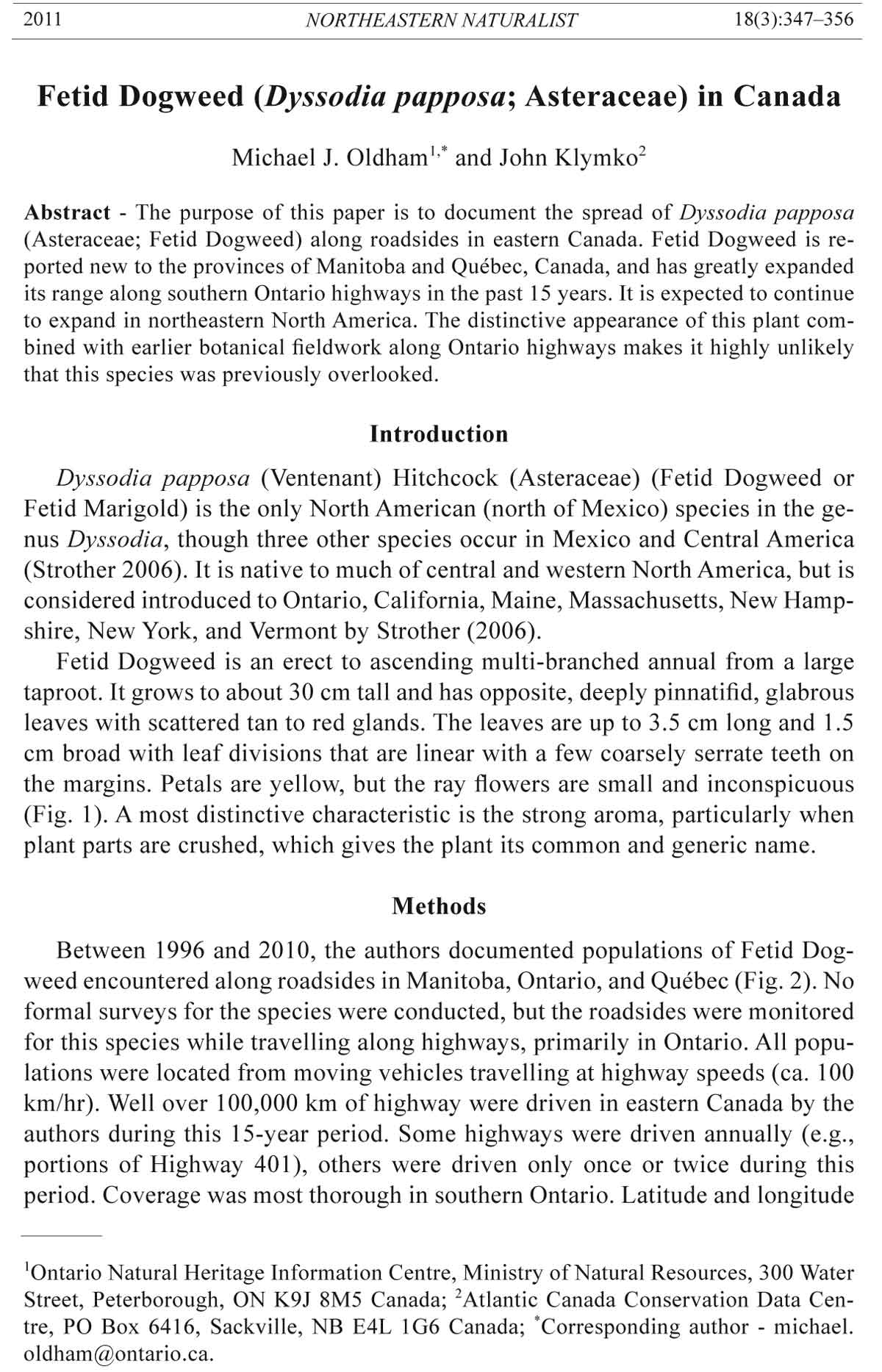
Figure 2. Fetid Dogweed forms the brown band along both edges of the Hwy. 401 center
median. Photograph taken on 9 Oct. 2009 from the County Road 22 (Shanly Road) overpass
in the United Couties of Leeds and Grenville, facing east. Photo by John Klymko.
350 Northeastern Naturalist Vol. 18, No. 3
and now occurs from Essex County which borders Michigan, to the United
Counties of Stormont, Dundas, and Glengarry, which border Québec. There are
records from 20 southern Ontario counties, with most records from Highway
401 (Fig. 3), though the species is spreading to smaller highways and in the
past decade has also been found along Highways 7, 22, 49, 115, 402, 403, 416,
and 417. Although Strother (2006) suggests it is a local and probably ephemeral
introduction in northeastern North America, the species is widespread,
persisting, and spreading in southern Ontario.
In 2009, Fetid Dogweed was collected for the first time in Manitoba along
Highway 1, where it occurs discontinuously from about 50 km east of Winnipeg
almost to the Ontario border, a distance of about 107 km along the highway.
Also in 2009, the species was discovered for the first time in Québec, where it
occurs in two isolated patches along Highway 20 near the Ontario border. Fetid
Dogweed is not listed for Manitoba or Québec by Scoggan (1978–1979), Kartesz
(1999), Strother (2006), Brouillet et al. (2010+) or other floristic lists.
It is very unlikely that Fetid Dogweed was overlooked previously along southern
Ontario highways since it typically occurs in extensive monotypic patches
often stretching for many kilometers, is distinctive in appearance at most times
of the year, and grows along major highways frequently travelled by botanists.
Except for one literature report from 1883, the lack of previous herbarium or
literature records of the species in eastern Canada suggests that Fetid Dogweed
is a recent colonist. Several Ontario botanists have been interested in the spread
of vascular plants, particularly halophytes, along provincial highways, and despite
several new species for southern Ontario (e.g., Crypsis schoenoides (L.)
Lamarck [Swamp Pricklegrass], Poa arida Vasey [Plains Bluegrass], Puccinellia
fasciculata (Torrey) Bicknell [Saltmarsh Alkaligrass], Spergularia media (L.)
Figure 3. Southern Ontario and southern Québec distribution of Fetid Dogweed.
2011 M.J. Oldham and J. Klymko 351
C. Presl ex Grisebach [Greater Sand-spurrey], Suaeda calceoliformis (Hooker)
Moquin-Tandon [Pursh’s Seepweed], Thinopyrum ponticum (Podpera) Z.-W.
Liu & R.R.-C. Wang [Tall Wheatgrass]) being reported along highways (Catling
and McKay 1980, Oldham et al. 1995, Webber et al. 1985), Fetid Dogweed
was not seen along Ontario highways until 1996. If Fetid Dogweed was present
along southern Ontario roads prior to the 1990s, it would almost certainly have
been detected during studies documenting the spread of Carex praegracilis W.
Boott (Clustered Field Sedge), Taraxacum section Palustria (marsh dandelion),
and Spergularia (sand-spurrey) species along Ontario highways in the 1970s
and1980s (Brunton 1989, 1990; Brunton and Catling 1982; Catling and Mc-
Kay 1975, 1980; Darbyshire 1987; Reznicek and Catling 1987; Reznicek et al.
1976).
Eastern Canadian records known to us are listed below and mapped in
Figure 3. In the listing of records, the first specimen record for each Ontario
county (or regional municipality) is listed first or, if we know of no collection
for a particular county, the first sight or literature record is provided, followed
by additional records mapped in Figure 3. A more complete listing of over 150
Ontario records is available from the authors.
All recent eastern Canadian records have been from roadsides where the species
typically grows in dry gravel between the road surface and the grassy road
shoulder. The species commonly forms extensive patches, sometimes growing
continuously for many kilometers. While most easily observed during its latesummer
blooming period (flowering has been observed from 12 September to
28 October in southern Ontario), Fetid Dogweed is also readily identifiable in
winter, since dead plants form a distinctive and conspicuous brown and later
black band along gravel road shoulders (Fig. 2). The species does not appear to
compete well with other vegetation and does not grow in areas of dense vegetation
or in moist areas such as roadside ditches. Associates are typical weedy
species of southern Ontario roadsides, including Ambrosia artemisiifolia L.
(Common Ragweed), Atriplex patula L. (Spear Orache), Erigeron canadensis
L. (Canada Horseweed), Panicum capillare L. (Common Panicgrass), Plantago
major L. (Common Plantain), Polygonum aviculare L. ssp. depressum (Meisner)
Arcangeli (Oval-leaved Knotweed), Salsola collina Pallas (Slender Russian
Thistle), Setaria viridis (L.) P. Beauvois (Green Foxtail), Sonchus arvensis
L. (Field Sow-thistle), and Sporobolus vaginiflorus (Torrey ex A. Gray) Alph.
Wood (Sheathed Dropseed).
The rapid spread of Fetid Dogweed along southern Ontario highways is similar
to that of the sedge Carex praegracilis, another native of central and western
North America, which was first found in southern Ontario in 1973 and is now a
common roadside weed along major roads in southern Ontario and elsewhere in
northeastern North America (Reznicek and Catling 1987, Reznicek et al. 1976).
Some of the other species spreading along southern Ontario highways that are
salted in winter are halophytes originating from the coast of eastern North America
or saline areas of western North America (Catling and McKay 1980, 1982).
352 Northeastern Naturalist Vol. 18, No. 3
Fetid Dogweed is not considered a halophyte and does not occur in the most
saline highway habitats (which are typically center median ditches receiving
runoff from both sides of the highway); however, it is probably salt-tolerant given
its extensive distribution along Highway 401, which is heavily salted in winter.
Undoubtedly, the dispersal of Fetid Dogweed along major roadways is facilitated
by the same factors responsible for the rapid spread of C. praegracilis, such as
mowing and construction equipment, vehicle traffic (seeds or whole plants blown
by the movement of vehicles or trapped in tires or elsewhere on vehicles), and
snow plows. The extensive and uninterrupted linear habitats of major roadways
provide perfect dispersal corridors for species adapted to these habitats, and we
anticipate that Fetid Dogweed will continue to expand its range along roadsides
in northeastern North America.
Eastern Canada Records
All Manitoba and Québec records are listed; for Ontario, the first specimen
record for each county is listed first or if no specimen record is known,
the first sight or literature record is provided, followed by additional records
mapped in Figure 3. Herbarium acronyms follow Index Herbariorum (Thiers,
continuously updated).
Manitoba: Hwy. 1, ca. 33 km SE of Winnipeg Perimeter Highway, ca. 107
road km W of Ontario border (49.67258N, -96.57572W), 14 Sept. 2009, M.J.
Oldham & J.M. Bowles 37180 (CAN, MICH, MAN); Hwy. 1 at Cusson Road,
ca. 35.5 road km W of Ontario border (49.63419N, -95.59298W), 14 Sept. 2009,
M.J. Oldham & J.M. Bowles 37181 (DAO, MAN, NHIC); Hwy. 1, ca. 500 m W
of Ontario border (49.73834N, -95.15982W), 14 Sept. 2009, M.J. Oldham & J.M.
Bowles 37182 (MAN).
Ontario: CHATHAM-KENT: Hwy. 401, 2.5 km NNW of North Buxton,
ca. 10 km SW of Chatham (42.32479N, -82.24492W), 20 Sept. 2001, M.J.
Oldham & K.E. Brodribb 27195 (MICH); Hwy. 401, westbound (42.31701N,
-82.27894W), 12 Sept. 2001, M.J. Oldham, W.D. Bakowsky & K.E. Brodribb
sight record; Hwy. 401, westbound (42.53824N, -81.79813W), 12 Sept.
2001, M.J. Oldham, W.D. Bakowsky & K.E. Brodribb sight record; Hwy. 401
(42.44311N, -81.96928W), 11 May 2007, M.J. Oldham sight record; Hwy. 401
(42.31571N, -82.29531W), 21 May 2010, M.J. Oldham sight record; Hwy. 401
at Merlin Road (42.30887N, -82.31271W), 21 May 2010, M.J. Oldham sight
record; Hwy. 401 at County Road 2, Tilbury (42.27939N, -82.37409W), 21 May
2010, M.J. Oldham sight record; DURHAM: Hwy. 401, ca. 2.4 km E of Hwy. 17
to Newcastle (43.91657N, -78.55671W), 12 Oct. 2009, J. Klymko s.n. (OAC);
Hwy. 401, eastbound (43.93489N, -78.47169W), 12 Oct. 2009, J. Klymko sight
record; ELGIN: Hwy. 401 eastbound, ca. 200 m W of Furnival Road interchange
(42.58174N, -81.71166W), 26 Sept. 1996, M.J. Oldham 19611 (DAO, MICH,
TRTE, UWO); Hwy. 401 (42.74233N, -81.42264W), 11 May 2007, M.J. Oldham
sight record; Hwy. 401 (42.64094N, -81.56777W), 7 Sept. 2007, M.J. Oldham
2011 M.J. Oldham and J. Klymko 353
& T. McIntosh sight record; Hwy. 401 (42.7613N, -81.39531W), 7 Sept. 2007,
M.J. Oldham & T. McIntosh sight record; Hwy. 401, just west of Union Road (to
Shedden) (42.76626N, -81.38831W), 27 Sept. 2007, M.J. Oldham, S. Brinker,
J.M. Bowles, B. Ford & J. Gould sight record; ESSEX: Hwy. 401 westbound,
0.75 km E of Hwy. 42 (Mill Street W or Co. Rd. 2) exit, 0.15 km W of Tilbury
Creek (42.26726N, -82.44960W), 12 Sept. 2001, M.J. Oldham, W.D. Bakowsky
& K.E. Brodribb sight record; Hwy. 401 at Essex Road 42, Tilbury (42.26696N,
-82.45124W), 21 May 2010, M.J. Oldham sight record; Hwy. 401 (42.25919N,
-82.49160W), 21 May 2010, M.J. Oldham sight record; FRONTENAC: Hwy. 7,
ca. 4.3 road km W of Hwy. 509, near Sharbot Lake (44.77234N, -76.73379W),
16 Sept. 2008, M.J. Oldham, S. Brinker & W.D. Bakowsky 35943a (DAO,
MICH, TRTE); Hwy. 401, westbound, at Exit 632, Joyceville Road (44.32397N,
-76.32164W), 1 Oct. 2009, M.J. Oldham 37239 (TRTE); Hwy. 401 Westbound
(44.28419N, -76.69486W), 1 Oct. 2009, M.J. Oldham sight record; Hwy. 401,
eastbound (44.30048N, -76.41315W), 12 Oct. 2009, J. Klymko sight record;
Hwy. 401, near Deseronto exit (44.24434N, -77.06537W), 12 Nov. 2004, M.J.
Oldham sight record; Hwy. 401, east of Napanee (44.25412N, -76.99570W),
12 Nov. 2004, M.J. Oldham sight record; HALTON: Hwy. 403, eastbound lane,
ca. 1.75 km E of Hwy. 6 interchange (43.30120N, -79.87522W), 12 Oct. 2009,
J. Klymko s.n. (OAC); HASTINGS: Belleville (near), along Hwy. 401, 16 Oct.
2006, Stuart G. Hay 06-140 (DAO, MT); Hwy. 401 (44.10685N, -77.66812W), 3
May 2007, M.J. Oldham sight record; Hwy. 49, at north end of bridge over Bay
of Quinte (Skyway Bridge) (44.17694N, -77.08667W), 17 Sept. 2008, J. Klymko
s.n. (OAC); Hwy. 401 Westbound (44.22427N, -77.21045W), 1 Oct. 2009, M.J.
Oldham sight record; Hwy. 401, eastbound (44.20786N, -77.34915W), 12 Oct.
2009, J. Klymko sight record; Hwy. 401, near Shannonville exit (44.22231N,
-77.22471W), 12 Nov. 2004, M.J. Oldham sight record; LAMBTON: Hwy. 402,
between Hwy. 40 and Mandaumin Rd., eastbound lane, 11 Sept. 2008, J. Klymko
s.n. (OAC); LEEDS & GRENVILLE: Gananoque exit on Hwy. 401 (44.3434N,
-76.1726W), 17 Sept. 2006, P.M. Catling & B. Kostiuk s.n. (DAO); Hwy. 401
(44.35303N, -76.10092W), 4 Nov. 2001, M.J. Oldham & M. Delisle-Oldham
sight record; 0.5 km west of Mallorytown Road (Km 675), south side Highway
401, Front of Escott Tp., (44.46999N, -75.87277W), 13 Sept. 2005, D.F.
Brunton sight record; Hwy. 401, westbound (44.70845N, -75.56024W), 1 Oct.
2009, M.J. Oldham 37238 (DAO); Hwy. 416, south of Kemptville (44.97062N,
-75.60291W), 1 Oct. 2009, M.J. Oldham 37237 (CAN, TRT); Hwy. 401 westbound
at Exit 661 (44.38262N, -75.98156W), 1 Oct. 2009, M.J. Oldham sight
record; Hwy. 401 westbound at Co. Rd. 18 (44.72177N, -75.52712W), 1 Oct.
2009, M.J. Oldham sight record; Growing on shoulder of Hwy. 22 (Shanly Rd.),
just south of the bridge over Hwy. 401 (44.81046N, -75.40481W), 9 Oct. 2009,
J. Klymko s.n. (OAC); LENNOX & ADDINGTON: N side of Hwy. 401, 2.5 km
E of Palace Road, Napanee (44.27306N, -76.89889W), 12 Sept. 2005, D.F. Brunton
16525 (WIN); Switzerville Road at Hwy. 401 (44.27473N, -76.87819W), 9
Nov. 2001, M.J. Oldham sight record; 1 km west of Odessa Road at Hwy. 401
354 Northeastern Naturalist Vol. 18, No. 3
(44.28194N, -76.72844W), 9 Nov. 2001, M.J. Oldham sight record; Hwy. 401
at Napanee (44.26585N, -76.95883W), 18 Sept. 2006, G. Bryant sight record;
Hwy. 401, westbound (44.28381N, -76.69959W), 1 Oct. 2009, M.J. Oldham
37240 (DAO); MIDDLESEX: Hwy. 401 between Elgin Rd. (exit 203) and Putnam
Rd. (exit 207), S shoulder of eastbound lane (42.97066N, -80.98397W),
3 Oct. 2008, J. Klymko s.n. (OAC); NIAGARA: Fort Erie, pre-1883, D. Day
(1883, literature record); NORTHUMBERLAND: Hwy. 401, westbound, ca.
6.6 km E of Hwy. 30, ca. 0.55 km W of Hastings County border (44.09905N,
-77.69548W), 1 Oct. 2009, M.J. Oldham 37242 (CAN); Hwy. 401 westbound
(44.08519N, -77.72201W), 1 Oct. 2009, M.J. Oldham sight record; Hwy. 401,
eastbound (43.94198N, -78.43963W), 12 Oct. 2009, J. Klymko sight record;
Hwy. 401, eastbound (43.98187N, -78.23541W), 12 Oct. 2009, J. Klymko sight
record; Hwy. 401, eastbound (44.04321N, -77.84229W), 12 Oct. 2009, J. Klymko
sight record; OTTAWA-CARLETON: Hwy. 416, 800 m N of Roger Stevens Dr.,
approx. 30 km S of Ottawa (45.15400N, -75.68374W), 18 Sept. 2008, J. Klymko
s.n. (OAC); Hwy. 417, Kanata (45.29754N, -75.93170W), 18 Sept. 2008, M.J.
Oldham, S. Brinker & W.D. Bakowsky sight record; north side of median of
Hwy. 417 below Huntmar Road overpass, Kanata, City of Ottawa (45.29754N,
-75.93170W), 28 Oct. 2008, D.F. Brunton 17375 (DAO 841495); Hwy. 416, 0.5
km ENE Cranberry Creek, 3.3 km ESE North Gower (45.12462N, -75.67527W),
22 Nov. 2009, F.W. Schueler, A. Karstad Schueler, L. Leader sight record; Hwy. 7
near Hazeldean Road (45.249184N, -75.97054W), Nov. 2008, P.M. Catling sight
record; OXFORD: eastbound lane, Hwy. 401, between Putnam Rd (exit 208) and
Culloden Rd (exit 216) (42.99408N, -80.90317W), 3 Oct. 2008, J. Klymko s.n.
(OAC); Hwy. 401, eastbound (43.23723N, -80.58451W), 3 Oct. 2008, J. Klymko
sight record; PETERBOROUGH: Hwy. 115, ca. 1 km S of Airport Road exit, Peterborough
(44.24226N, -78.36709W), 18 Sept. 2010, M.J. Oldham 38585 (DAO,
TRT); PRESCOTT & RUSSELL: Hwy. 417, just E of Hwy. 17, E of Hawkesbury
(45.56455N, -74.49643W), 17 Sept. 2008, M.J. Oldham, S. Brinker & W.D. Bakowsky
35944a (DAO); STORMONT, DUNDAS & GLENGARRY: Cornwall,
along Hwy. 401, 19 Oct. 2007, S.G. Hay 07-205 (DAO, MT); Hwy. 401, eastbound
(44.89321N, -75.25547W), 22 Apr. 2007, M.J. Oldham sight record; Hwy.
401, eastbound (44.98362N, -75.06604W), 22 Apr. 2007, M.J. Oldham sight record;
Hwy. 401, eastbound (45.08521N, -74.60492W), 22 Apr. 2007, M.J. Oldham
sight record; N side of Hwy. 401, 3.4 km ENE of Curry Hill and 1 km from the
Quebec border (45.20301N, -74.36015W), 7 Nov. 2009, P.M. Catling s.n. (DAO
843932); Hwy. 401 (44.99324N, -75.04309W), 24 Aug. 2010, M.J. Oldham &
M. Delisle-Oldham sight record; WATERLOO: Hwy. 401, eastbound lane, just E
of Hespeler Rd. (exit 282) (43.41402N, -80.32563W), 12 Oct. 2009, J. Klymko
s.n. (OAC); Hwy. 401, eastbound (43.41630N, -80.29657W), 12 Oct. 2009, J.
Klymko sight record; WELLINGTON: Hwy. 401, eastbound lane, between Hwy.
6 (exit 295) and Townline Rd. (exit 286) (43.44083N, -80.21311W), 3 Oct. 2008,
J. Klymko s.n. (OAC); Hwy. 401, eastbound (43.42774N, -80.26533W), 12 Oct.
2009, J. Klymko sight record.
2011 M.J. Oldham and J. Klymko 355
Québec: VAUDREUIL-SOULANGES: Hwy. 20, eastbound (45.21508N,
-74.33665W), 9 Oct. 2009, J. Klymko s.n. (OAC, DAO); Hwy. 20, eastbound
(45.21138N, -74.34292W), 12 Oct. 2009, J. Klymko sight record.
Acknowledgments
Gisele Mitrow and Paul Catling provided specimen data from Agriculture Canada
(DAO). Daniel Brunton, Frederick Schueler, and George Bryant provided records and other
information from their own fieldwork in southern Ontario. Vernon Harms kindly provided
information on the occurrence of Dyssodia papposa in Saskatchewan. Wasyl Bakowsky,
Jane Bowles, Sam Brinker, and Kara Brodribb assisted with fieldwork. Sean Blaney, David
Mazerolle, Cynthia Huebner, and three anonymous reviewers provided helpful comments
on the manuscript. Sarah Robinson prepared the distribution map. Publication costs were
paid for by the Ontario Ministry of Natural Resources and Natureserve Canada.
Literature Cited
Brouillet, L., F. Coursol, M. Favreau, M. Anions, P. Bélisle, and P. Desmet. 2010+.
VASCAN, the Database of Vascular Plants of Canada. Available online at http://data.
canadensys.net/vascan/. Accessed 25 Februrary 2011.
Brunton, D.F. 1989. The Marsh Dandelion (Taraxacum section Palustria; Asteraceae) in
Canada and the adjacent United States. Rhodora 91:213–219.
Brunton, D.F. 1990. More on Sea-spurry (Spergularia spp.) in the Ottawa District. Trail
& Landscape 24(2):52–55.
Brunton, D.F., and P.M. Catling. 1982. The Slender Sedge (Carex praegracilis) new to
the Ottawa District: An example of contemporary plant migration. Trail & Landscape
16:152–157.
Catling, P.M., and S.M. McKay. 1975. Associations of halophytic plants in the Toronto
region. Ontario Field Biologist 29(1):50–55.
Catling, P.M., and S.M. McKay. 1980. Halophytic plants in southern Ontario. Canadian
Field-Naturalist 94(3):248–258.
Catling, P.M., and S.M. McKay. 1982. A review of the occurrence of halophytes in the
eastern Great Lakes region. Michigan Botanist 20(4):167–179.
Darbyshire, S.J. 1987. Sand-spurry in the Ottawa District. Trail & Landscape 21:244–245.
Day, D. 1883. The plants of Buffalo and its vicinity. Bulletin of the Buffalo Society of
Natural Sciences 4:65–279.
Harms, V.L. 2003. Checklist of the Vascular Plants of Saskatchewan and the Provincially
and Nationally Rare Native Plants in Saskatchewan, Including Important Synonyms,
Authors of Epithets, Common Names, and Various Status Indicators. University of
Saskatchewan Extension Press, Saskatoon, SK, Canada. 328 pp.
Hudson, J.H. 1994. Plant discoveries in Saskatchewan, 1988–92, featuring Serpent
Spurge and Fluffweed. Blue Jay 52(3):126–129.
Kartesz, J.T. 1999. A Synonymized Checklist and Atlas with Biological Attributes for
the Vascular Flora of the United States, Canada, and Greenland. First Edition. In J.T.
Kartesz and C.A. Meacham. Synthesis of the North American Flora, Version 1.0.
North Carolina Botanical Garden, Chapel Hill, NC. Compact Disk.
Oldham, M.J., S.J. Darbyshire, D. McLeod, D.A. Sutherland, D. Tiedje, and J.M.
Bowles. 1995. New and noteworthy Ontario grass (Poaceae) records. Michigan Botanist
34:105–132.
356 Northeastern Naturalist Vol. 18, No. 3
Reznicek, A.A., and P.M. Catling. 1987. Carex praegracilis (Cyperaceae) in eastern
North America: A remarkable case of rapid invasion. Rhodora 89(858):205–216.
Reznicek, A.A., P.M. Catling, and S.M. McKay. 1976. Carex praegracilis W. Boott, recently
adventive in southern Ontario. Canadian Field-Naturalist 90:180–183.
Scoggan, H.J. 1978–1979. The Flora of Canada: Parts 1–4. National Museum of Natural
Sciences, Publications in Botany No. 7 (1–4), Ottawa, ON, Canada. 1711 pp.
Strother, J.L. 2006. Dyssodia. Pp. 230–231, In Flora of North America Editorial Committee
(Eds.). Flora of North America Volume 21. Oxford University Press, New York,
NY. 616 pp.
Thiers, B. [continuously updated]. Index Herbariorum: A global directory of public herbaria
and associated staff. New York Botanical Garden's Virtual Herbarium. Available
online at http://sweetgum.nybg.org/ih/. Accessed 25 February 2011.
Webber, J.M., D. McLeod, and R.S.W. Bobbette. 1985. More new and interesting grass
records for southern Ontario. Canadian Field-Naturalist 99(2):141–146.