Ecosystem Modeling in Cobscook Bay, Maine: A Boreal, Macrotidal Estuary
2004 Northeastern Naturalist 11 (Special Issue 2):23–50
Modeling Tidal Circulation and Exchange in
Cobscook Bay, Maine
DAVID A. BROOKS1
Abstract - Cobscook and Passamaquoddy Bays and their connecting passages
lie at the entrance to the Bay of Fundy, on the eastern boundary between the
United States and Canada where the mean tidal range is about 6 m. Vigorous
tidal currents maintain cold temperatures and efficient exchange with offshore
waters year-round. Over the last several decades, a net-pen salmon aquaculture
industry has developed in both bays. Recent outbreaks of fish diseases have led
to heightened concerns about tidal coupling between net-pen sites and potential
pathways for disease transmission. This paper summarizes a Cobscook Bay
circulation study by Brooks et al. (1999) and presents some new results to
improve understanding of the tidal circulation and potential exchange pathways
linking the bays.
A dipole pair of back-eddies forms in the central part of Cobscook Bay on
each flood and plays an important role in the dispersion and retention of
particles. Direct and indirect observations support the existence of the eddy pair
and some associated flow details. Model flushing times are a day or two in the
Outer Bay where most aquaculture lease sites are located but a week or longer in
the inner arms of the Bay. The inner part of South Bay appears to be a repository
for particulate matter. Model experiments including both bays and their connecting
passages suggest that most water entering Cobscook Bay comes from
Head Harbor Passage adjacent to Campobello Island, illustrating the importance
of well-coordinated international plans for ecosystem management.
Introduction and Background
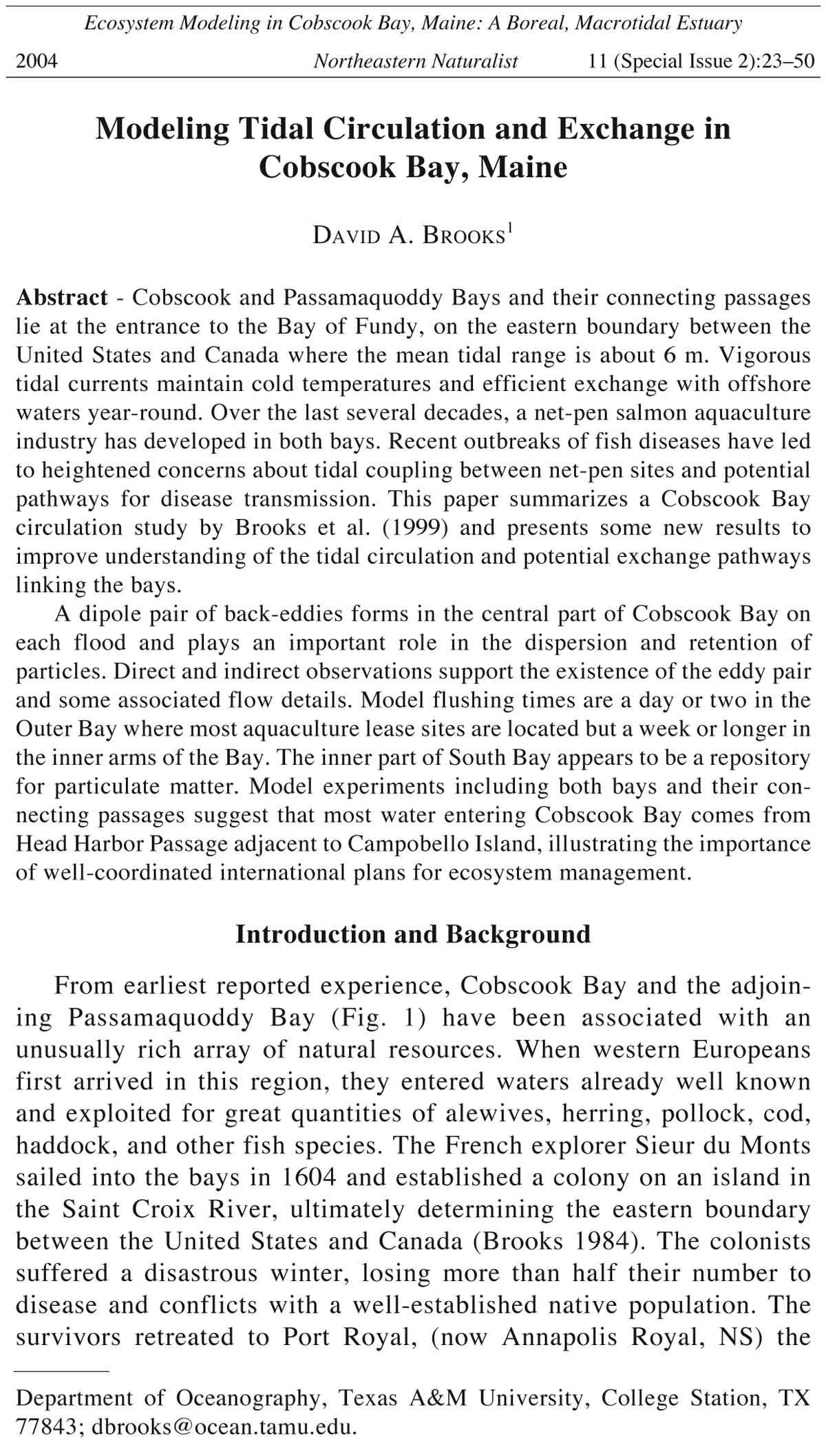
From earliest reported experience, Cobscook Bay and the adjoining
Passamaquoddy Bay (Fig. 1) have been associated with an
unusually rich array of natural resources. When western Europeans
first arrived in this region, they entered waters already well known
and exploited for great quantities of alewives, herring, pollock, cod,
haddock, and other fish species. The French explorer Sieur du Monts
sailed into the bays in 1604 and established a colony on an island in
the Saint Croix River, ultimately determining the eastern boundary
between the United States and Canada (Brooks 1984). The colonists
suffered a disastrous winter, losing more than half their number to
disease and conflicts with a well-established native population. The
survivors retreated to Port Royal, (now Annapolis Royal, NS) the
Department of Oceanography, Texas A&M University, College Station, TX
77843; dbrooks@ocean.tamu.edu.
24 Northeastern Naturalist Vol. 11, Special Issue 2
following spring, but not before recording that the native-American
name Passamaquoddy referred to great quantities of pollock taken
from the Bay (Kilby 1888).
Figure 1. The Cobscook–Passamaquoddy Bay archipelago at the entrance to the
Bay of Fundy, showing the mainland, passages, and islands defining the bays.
The international border is shown by the dash-dotted line. The inset box identifies
the domain of the circulation model for Cobscook Bay.
2004 D.A. Brooks 25
Cobscook Bay, ME, is located at the mouth of the Bay of Fundy,
where the mean tidal range is 5.7 m (Figs. 1 and 2). The consequent
vigorous exchange with the offshore waters is largely responsible for
the unusually productive and diverse ecosystem of the Bay environment
(Larsen 2004). In the first half of the twentieth century, abundant herring
supported a prominent sardine industry that collapsed in the late
1950s, for reasons not well understood. Likewise, stocks of cod and
haddock have significantly declined in recent decades. Currently,
Cobscook Bay supports a wide variety of benthic organisms (Trott
2004), including scallops, clams, mussels, urchins, and macroalgae, all
of which are commercially important.
In the early 1990s, commercial net-pen salmon aquaculture was
introduced in Cobscook and Passamaquoddy Bays. Since then, aquaculture
has become an important contributor to the economy on both sides
of the border. The aquaculture industry in Maine generates revenues of
about $75 million annually, of which about 90% is from salmon farms,
Figure 2. Map showing the detailed geographic features and place-names defining
Cobscook Bay, ME. Note the location of the Dennys and Pennamaquan Rivers.
For reference, the Bay is divided into Inner, Central, and Outer sub-regions.
26 Northeastern Naturalist Vol. 11, Special Issue 2
placing salmon aquaculture second only to lobsters in importance to the
total fishery economy (Sowles and Churchill 2004).
The increasing density of salmon pens leads to questions about
sustainable levels for aquaculture in the bays. Concerns focus on
nutrient loading and the potential for eutrophication associated with
concentrated sources of fish wastes and unconsumed fish feed near
pen sites. The central questions relate to the significance of aquaculture-
related nutrient sources compared to natural ones, and the capacity
of the tidal circulation to flush the Bay of pollutants and waste
products. Recent outbreaks of fish diseases, particularly infectious
salmon anemia (ISA), have lead to fallowing of fish farms and destruction
of fish on both sides of the border, severely impacting the
local economy. There is also growing concern about potential impacts
of farmed-fish diseases on the wild salmon population (National
Research Council 2003). The recent ISA occurrences have
highlighted the need for international coordination and management
of aquaculture operations based on sound scientific knowledge and
cooperation between the various stakeholders.
To address such questions, it is necessary to understand the capacity
of the tidal circulation to flush pollutants from the bays. It is also
important to assess the effectiveness of tidal water movements and
mixing that may couple the bays and provide cross-boundary pathways
for transmission of pathogens. As a step in this direction, a hydrodynamic
circulation model recently was used to study the tidal circulation,
dispersion, and flushing times in Cobscook Bay (Brooks et al. 1999).
The modeling was part of a larger ecosystem study that modeled energy
flow through the Bay and considered nutrient and oxygen distributions
in the Bay, as well as seasonal measurements of the temperature and
salinity, bottom sediments, and the distribution and growth rates of
micro- and macroalgae (Campbell 2004). The present article briefly
reviews results from the model study and focuses on the impact of its
central result: a pair of back-set eddies that develops in the Central Bay
on each flooding tide. The paper also introduces some newer results
from a circulation model that encompasses both bays and illustrates
some aspects of the tidal coupling between them.
The tides
The unusually large tidal range in Cobscook and Passamaquoddy
Bays results from their immediate proximity to the Bay of Fundy, well
known for extreme tides. The large range is due to a near-resonance of
the semidiurnal tide of the North Atlantic Ocean with the Gulf of
Maine-Bay of Fundy system (Garrett 1972). The principal lunar
semidiurnal tidal constituent (M-2), by far the most important in the
Quoddy region, has a period of 12.42 hours, or 12 hours and about 25
2004 D.A. Brooks 27
minutes. Generally, two highs and two lows occur per solar day, but
the times of high and low water are delayed each day by about 50
minutes because of the moon’s prograde orbital motion. For discussion
purposes, it is convenient to reckon the M-2 tidal period as exactly 12
lunar hours, noting that one lunar hour equals 1.035 solar hours.
Previous studies
Because of its large tidal range and nearly enclosed nature, the
Cobscook-Passamaquoddy (“Quoddy”) region has obvious potential
as a site for tidal-power generation (Brooks 1992, Trites 1961). Most
of the available oceanographic data from the region have been collected
as parts of studies related to various tidal power projects
(Larsen and Webb 1997).
Historical physical data from Cobscook Bay consist of temperature
and salinity measurements at a few locations in different seasons
(Loucks et al. 1974, Trites and Garrett 1983) and some residual current
hints from a few drift bottles that escaped from Passamaquoddy Bay
(Chevrier and Trites 1960). In a literature review of the Quoddy region,
McGrail (1973) noted that, aside from tidal height and tidal current
predictions, data from Cobscook Bay were sparse. To provide the data
necessary to initialize a computer model, six survey cruises were conducted
between early spring and late fall 1995 as part of the Cobscook
Bay ecosystem study (Phinney et al. 2004).
Brooks and Churchill (1991) and Brooks (1992) modeled the circulation
in Cobscook Bay and tidal-power schemes in the Passamaquoddy
region, respectively. Panchang et al. (1997) modeled waste transport at
several aquaculture sites in Cobscook Bay.
The Circulation Model
The numerical model used for this study is a derivative of the
Princeton Ocean Model known as ECOM-si (Blumberg and Mellor
1987, Casulli and Cheng 1992). Bottom topography is represented with
a stretched vertical coordinate to preserve full vertical resolution in
variable water depth. Vertical mixing is determined by the turbulence
closure scheme of Mellor and Yamada (1982), and horizontal mixing
follows the Smagorinsky (1963) method, which depends on the velocity
gradients and the grid spacing. A free surface boundary allows application
of tidal forcing and propagation of surface gravity waves.
The coastal outline and geographic place names of land and water
areas for Cobscook Bay are shown in Figure 2. The digitized outline
of Cobscook Bay and several smoothed depth contours are shown in
Figure 3. The horizontal resolution of the model grid is 255 m, and
the vertical structure is represented by 10 cells, or 11 levels, including
the surface and the bottom. The topography-following coordinate
28 Northeastern Naturalist Vol. 11, Special Issue 2
preserves the full vertical resolution of the model at all horizontal
locations, leading to a grid with about 21,000 cells representing the
waters of the Bay. Fresh water from the Dennys and Pennamaquan
Rivers is included at the locations shown in Figure 2. The model
exchanges water and other information across the open boundary between
Eastport and Lubec.
The water depth relative to mean low water (MLW) in each model
grid cell was determined by manual interpolation from National Oceanic
and Atmospheric Administration (NOAA) chart 13328, which has
sufficient soundings such that at least one depth value typically was
available in each cell. The mean was used in cells with more than one
chart sounding; no additional smoothing was applied in the model
calculations. The shaded region in Figure 3, with depths greater than 20
m below MLW, defines the principal tidal channel.
The model used does not allow for wetting and drying of grid cells,
so the intertidal zone is never exposed in the model and is not fully
represented. To avoid numerical difficulties, the model intertidal region
was “dredged” to maintain a small non-zero depth (0.45 m) at low water.
Figure 3. Map showing the representation of bottom depth of Cobscook Bay,
ME, below mean low water in the model. The contours are smoothed and show
depths of 10, 15, and 20 m. The shaded region is the main tidal channel with
depths greater than 20 m. Depths were interpolated from NOAA Chart 13328.
2004 D.A. Brooks 29
Cobscook Bay has approximately 37 km2 of intertidal flats, compared to
a total Bay surface area of about 74 km2 at low water (Larsen et al.
2004), so this inadequacy is a significant shortcoming.
Figure 4. From the 24 July 1995 cruise, (A) temperature (°C) and (B) salinity
(ppt) on the vertical section between Birch and Gove Points that defines the
boundary between the Central and Outer Bays of Cobscook Bay. The view is
outward toward the open boundary, with Birch Point on the left. The section was
occupied near the time of a low tide.
B
A
30 Northeastern Naturalist Vol. 11, Special Issue 2
Initial data
The survey cruises sampled important sections at the same phase
of the tide during successive springs and neaps in the spring, summer,
and fall seasons (a winter cruise was not scheduled). The cruise
tracks were chosen to provide vertical sections of temperature and
salinity and other properties along lines separating the eastern,
central, and western regions of the Bay. Phinney et al. 2004 give
additional details about the data sets and station locations.
The model experiments discussed here were initialized with data
collected 3 May 1995. Figures 4A and 4B show the temperature and
salinity on the vertical section between Birch and Gove Points on 24
July 1995, which can be compared with the May data on the same
section shown by Brooks et al. 1999; both sections were completed
near a neap low tide. The ranges of temperature and salinity on the
section are small, and there is only weak vertical stratification in the
presence of the strong tidal mixing, but there are obvious horizontal
gradients. The freshest and warmest water is found south of the center
of the channel, on the Gove Point side. In summer (July), the midchannel
temperatures are slightly lower than at the channel sides
because relatively cooler offshore waters are advected inward and
mixed upward in the channel. In spring (May), the effect is reversed
and the mid channel temperatures are slightly higher because relatively
warmer offshore waters are advected into the Bay.
Forcing and boundary conditions
Tidal forcing was applied by oscillating the sea level height at the
open boundary with the M-2 period and with amplitude 2.85 m, corresponding
to the mean semidiurnal tidal range of 5.7 m. Only the M-2
tidal constituent is considered, so there is no spring-neap variation,
diurnal inequality, or lunar ellipticity factor in the model tides.
River run-off was specified from monthly mean fluxes determined
from gauged flow in the Dennys River. For the Pennamaquan River,
which had no flow data available, the flux was estimated to be 45% of
the Dennys River flux, based on the relative area of the drainage basins
of the two rivers. The maximum flow of 8 m3s-1 in the Dennys River
occurred in April, with a secondary maximum of 5.5 m3s-1 in January.
The temperature and salinity in the grid cells nearest the river mouths
were set at 5 °C and 15 ppt.
The Model Tidal Regime
The model was started from May initial conditions and run for ten
days to achieve a steady-state. For the subsequent M-2 cycle, the dependent
variables at all levels in all grid cells were saved for analysis.
2004 D.A. Brooks 31
Because of the large volume of model data, only a few highlights can be
shown in printed figures. Animation sequences, showing successive
model output frames like a movie, provide an effective way to present
the tidal circulation. Examples can be viewed on the Cobscook web site
(http:// cobscook.tamu.edu).
Brooks et al. (1999) give a detailed description of the model tidal
cycle, as well as more information about the model and boundary
conditions. The present discussion is limited to the central result and
its implications.
The eddy dipole
The flood and ebb currents generally follow the deep channel
from the open boundary into the Central Bay, with maximum current
speeds reaching about 2 m s-1. The rising flood is partially blocked by
the narrow opening leading into the Inner Bay, and as a result a pair
of counter rotating “back-set” eddies forms in the Central Bay. The
eddy doublet or dipole begins to form at about hour 9 in the model
cycle, near the time of maximum flood. The dipole reaches its greatest
development near hour 11 and remains clearly evident in the
surface currents at hour 12, when the next ebb is just beginning off
Gove Point and sea level is high at Eastport (Figs. 5A,B; times are
lunar hours after high water at Eastport). The northern eddy supplies
water to the rising tide in Pennamaquan and East Bays, and the southern
eddy directs part of the inflow into South Bay. The development
of the dipole largely determines how the flood spreads throughout the
Central Bay, and the eddies, particularly the southern one, play an
important role in the horizontal and vertical dispersion of particles
and tracers.
The southern eddy of the dipole extends nearly to the sea floor, as
shown by an east-west vertical section extending from the tip of
Denbow Neck to Seward Neck (Fig. 6). The contours show the northsouth
component of the water velocity averaged over one tidal cycle,
defining the tidal-residual circulation crossing the section. The dashed
contours indicate southward flow into South Bay and conversely for
the solid contours. The tidal-residual flow in the plane of the section,
shown by the arrows, is essentially horizontal and eastward (toward
Seward Neck) everywhere, indicating that the section is located
slightly south of the eddy center. Averaged over multiple tidal cycles,
there can be no net inflow or outflow in South Bay, and this is qualitatively
apparent from Fig. 6. The maximum residual speed is about 12
cm s-1 on the Denbow Neck side, which can be compared to the maximum
instantaneous surface speed of about 50 cm s-1 across the section
at hour 11 in the model tidal cycle (Fig. 5B).
32 Northeastern Naturalist Vol. 11, Special Issue 2
Figure 5A. Model surface currents in Cobscook Bay at 11 and 12 lunar hours
after high water at Eastport.
2004 D.A. Brooks 33
Figure 5B.
E x p a n d e d
view of
model surface
currents
at 11 and 12
lunar hours in
the Central
Bay region,
showing development
of
the eddy dipole.
Currents after 11 hours
Currents after 12 hours
34 Northeastern Naturalist Vol. 11, Special Issue 2
Tidal volumes
McGrail (1973) lists low water and intertidal volumes in Cobscook
Bay of 0.56 km3 and 0.49 km3, respectively. The corresponding model
values are 0.95 km3 and 0.54 km3. Thus, on average about half a cubic
kilometer of seawater enters the Bay on each flood and leaves on each
ebb — roughly comparable to the mean outflow of the Mississippi River
during the same interval (6.2 solar hours). By comparison, rivers bring
an insignificant amount of fresh water into the Bay, less than one
percent of the intertidal volume, but the freshening influence is noticeable
on the Birch-Gove section (Fig. 4).
The model low water volume is significantly larger than that reported
by McGrail. The difference is not explained by the model
treatment of the intertidal zone, which is never allowed to dry completely.
It is not clear where the outer boundary of Cobscook Bay was
defined by McGrail, yet this choice obviously affects the low-water
and high-water volumes.
The model high-water area, determined as the grid cell area (0.065
km2) times the number of “wet” cells (1392), is 90.5 km2, which can be
Figure 6. Vertical section of tidal-residual currents crossing the southern eddy in
the Central Bay (Fig. 5B). The transect runs from west on the left to east on the
right. Solid contours indicate northward currents, and dashed contours (negative
values) indicate southward currents crossing the section. Contours are labeled in
cm/s. Arrows show flow in the plane of the figure. From Baca (1998).
2004 D.A. Brooks 35
compared to the high-water area of 111 km2 determined by analysis of
satellite images (Larsen et al. 2004). Thus 20.5 km2 of nearshore intertidal
is excluded from the model domain because of grid limitations (cf.,
Figs. 2 and 9). The model low-water area exclusive of the intertidal,
represented by 1136 grid cells, is 73.8 km2, in almost exact agreement
with Larsen et al. 2004.
An independent estimate of the intertidal volume can be calculated
from the mean tidal range (2.85 m) and the satellite-derived intertidal
area (37 km2). Assuming a linear bottom slope in the intertidal region,
the total volume that must be exchanged with each tide is 0.53 km3, in
close agreement with both the model result and the McGrail value.
The model tidal prism, or relative intertidal fraction, defined as
(HW-LW)/HW volume, is 0.38, using values adjusted to account for the
“dredged” intertidal in the model. Thus, about one-third of the highwater
volume moves in and out of the Bay on each tide.
Bulk flushing time estimates
If the intertidal volume simply moved in and out of the Bay as a
surface layer with no vertical mixing, there would be no exchange with
deeper waters, leading to an infinite residence time for the deep waters.
However, there clearly is strong tidal mixing in the Bay and considerable
exchange between the intertidal and deeper waters during each tidal
cycle. If the vertical mixing were complete on each flooding tide and none
of the ebbing water re-entered on the next flood, then the bay-averaged
flushing time would be about 3 tidal cycles or 1.5 days, since about onethird
of the volume would be exchanged with each tide. This turns out to
be a reasonable overall value for the main tidal channel in the Outer Bay,
but there are wide variations over the entire Bay, as we shall see.
The eddy dipole: is it real?
The dipole pair of eddies that forms on each flood apparently plays a
central role in the dispersion of suspended and dissolved materials in
Cobscook Bay, so it is important to look for corroborating support for
the model result.
Direct support comes from a brief record of current measurements
collected at a mooring adjacent to an aquaculture site near Sheep
Cove (Fig. 2). The mooring was located just west and inshore of Red
Island, about 1 km west of Birch Point (Brooks and Churchill 1991).
Figure 7A shows three-day records of the eastward (solid line) and
northward (dashed line) currents measured at that mooring and
smoothed with a 2-hr low-pass filter. One of the interesting features
is the reversal from westward to eastward flow that occurs a few
hours after each flood begins. Brooks and Churchill (1991) suspected
that the reversal was caused by eddying in the lee of Red Island
during the flooding tide. However, the present model results show
36 Northeastern Naturalist Vol. 11, Special Issue 2
Time (hours)
Current speed (m/sec)
Modeled Sheep Cove Currents
Figure 7B. Modeled surface currents at Sheep Cove from the grid cell nearest
the location of the measured currents shown in Figure 7A. Note similar pattern
of flow reversal during each flood cycle.
Figure 7A. Measured near-surface currents at Sheep Cove site (see Fig. 2 for
location). Smoothed with 2-hr low-pass filter. Solid line shows east-west component.
Note flow reversal on each flood, e.g., at about 7, 19, 31 ... hours.
Sheep Cove 2hrlp: east (—), north (--)
Time (hours)
Current speed (cm/sec)
2004 D.A. Brooks 37
that the reversal happens as the northern member of the eddy dipole
expands eastward after the flood begins, causing the current at the
mooring location to set toward the southeast or east (Figs. 5A,B). The
model currents at the grid cell nearest the mooring location (Fig. 7B)
reveal a similar reversal on each flood cycle, with similar times and
duration of reversals. The comparison extends to interesting details
such as the multiple-staged ebbs evident in both the measured and
modeled currents. The diurnal inequality apparent in the measured
current is not reproduced by the model, because only the lunar
semidiurnal forcing component was used.
Recently, the eddy dipole has been directly observed by tracing the
surface flow with simple drifters (Fig. 8). Several replications of this
experiment were conducted by students at Shead Memorial High School
in Eastport, with the guidance of technical arts instructor Scott Fraser.
The students designed and built the neutral surface drifters from
ballasted PVC pipe without drogues. For the case shown (taken from the
students’ website, www.cobscook.org, where results from additional
experiments can be viewed), the drifters were released along the Birch-
Gove transect just as the flood was beginning. The students tracked the
drifters from small boats using portable Global Positioning System
receivers. The drifter tracks in Figure 8 reveal the existence of a
counter-rotating eddy pair in the Central Bay.
Landsat images of the Bay showing color-coded distributions of
surface turbidity provide indirect evidence of the eddy dipole (Fig. 9;
Larsen et al. 2004). The “class 3” green color marks relatively clear
offshore water entering the Bay near the time of maximum tidal flood.
The pattern reveals the northward and southward splitting of the flood as
it enters the constricted passage between Leighton and Denbow necks.
Low-altitude aircraft photographs also reveal part of the southern
eddy in surface sediments stirred up by scallop draggers (photos by
Laurice Churchill shown in Brooks et al. 1997). Accumulations of muddy
sediment on the bottom in the Central Bay appears to be associated with
the two eddies (Kelley and Kelley 2004), indicating persistence of the
eddy process over long times. The association suggests that the eddy
recirculation may concentrate sediments derived from net-pens, which
raises questions about potentially elevated levels of contaminants. It is
also known that the bacterium Aeromonas salmonicida, responsible for
the virulent fish disease furunculosis, can be accumulated in sediments
from fish farms (Husevag and Lunestad 1995, Stewart 1998).
Finally, local fisherman have reported that the tide sets northward
along the western side of Gove Point during most of the tidal cycle
(pers. comm. to D.A. Brooks).
Taken together, the direct and indirect observations as well as
local experience point to a persistent eddy dipole pattern that forms
38 Northeastern Naturalist Vol. 11, Special Issue 2
in the Central Bay during the flooding tide. Thus, with some confidence
we can address the consequences of the recurring pattern in the
tidal currents.
Mixing and Residence Times
The paths followed by neutrally-buoyant particles illustrate the chaotic
nature of the tidal stirring in Cobscook Bay. Figure 10 shows the tracks of
two particles released at the surface in adjacent model grid cells just as the
flood begins at Eastport. The two particles initially were separated by only
255 m (the grid spacing), but they soon diverged and followed very
different paths. One (dashed track) remained close to Seward Neck during
the flood, leaving the particle near the center of the channel off Birch Point,
where the ensuing ebb swept it out of the Bay. In contrast, the other particle
(solid track) was carried farther inward on the flood, where it interacted
with the northern eddy and became trapped for the remainder of the 10-day
experiment. The sensitivity of the particle tracks to small changes in their
initial position illustrates the non-linear nature of the tidal flow, called
“Lagrangian chaos” by Zimmerman (1986).
In an identical experiment, except that the particles were released
near the bottom instead of at the surface, both particles were eventually
flushed from the Bay, but only after many tidal cycles (Brooks et al.
Figure 8. Map of Cobscook Bay, showing tracks of six neutral surface drifters over
one tidal cycle starting at the beginning of the flood tide.. The drifters were
made and the experiment was conducted by Shead Memorial High School students.
2004 D.A. Brooks 39
Figure 9. Landsat satellite Thematic Mapper image of Cobscook Bay taken near
the time of maximum flood. The color scheme indicates relative levels of
surface turbidity. The class 3 green color marks relatively clear offshore water
entering the Bay. Image provided by Cynthia Erickson, Bigelow Laboratory for
Ocean Sciences.
1999). The second experiment indicates a different fate for the nearbottom
particles, which were sequestered in South Bay for most of the
10-day model run. The difference between surface and bottom particle
trajectories shows the importance of the three-dimensional structure of
the velocity field.
Tidally-averaged characteristics
A useful map of flushing time for the Bay can be developed by
seeding model runs with neutrally-buoyant surface particles released in
every grid cell at many different stages of the tidal cycle. For each run
one particle was released at each grid cell at the surface and tracked for
up to eight days after a two-day spin up period. Particles that were not
flushed from the Bay during each run were assigned a residence time of
eight days. The tidal-mean residence time was obtained by averaging
over 12 separate model runs with surface releases at each (lunar) hour of
the tidal cycle (Fig. 11A).
In the main channel of the Outer Bay, most particles escaped regardless
of the phase of the tide at the time of release, although there are a
few regions where particles did not escape when released into the flood
Classes
40 Northeastern Naturalist Vol. 11, Special Issue 2
(e.g., Johnson Bay) and a few places where none escaped regardless of
when they were released (e.g., Bar Harbor). Residence times less than
two days are almost entirely confined to the Outer Bay with the lowest
values on the eastern side, where the deep channel lies close to Moose
Island. In the extremities of the inner arms of the Bay, especially South
and Whiting Bays, none of the particles escaped, regardless of the phase
of the tide when released.
Some influence of the Central-Bay eddy dipole on residence time is
apparent. For example, residence times of three days or less occur in a
larger region of the northern eddy than in the southern one, and the
particles released into the northern eddy escaped the Bay during a
greater range of tidal phases than in the southern eddy. This result is
consistent with the tendency, noted earlier, for materials to be preferentially
directed toward South Bay and to be sequestered there.
The map of residence time shown in Figure 11A was determined
from advection of neutral particles released at the surface at all locations
Figure 10. Tracks of two neutral surface particles released in adjacent grid cells
(open circles) as the tidal flood begins. Stars on the tracks indicate time intervals
of 6 lunar hours, i.e., one-half tidal cycle. The particle indicated by the dashed
line was ejected from the bay in one tidal cycle; the other escaped the ebb and
became trapped for the duration of the model run.
2004 D.A. Brooks 41
uniformly over one tidal cycle. The result will be different for local
releases at specific sites, or with intermittent or non-uniform release
rates, or at subsurface locations. Sinking, dissolution, or aggregation of
particles, all of which may be important to the fate of unconsumed fish
feed pellets or waste products, for instance, have not been considered
here. It is also important to recall that the influence of the wind has not
been included in these model experiments.
The importance of the vertical structure of the flow on the bulk
flushing characteristics of the Bay is illustrated by a model experiment
in which the three-dimensional distribution of a passive tracer (“dye”) is
tracked by the model. In this experiment, every grid cell in the model
domain is initialized with a concentration of 100 units, and then the
concentration at all grid cells is determined as a function of time from
the same advection-diffusion equation that governs evolution of the
model temperature and salinity fields. The vertical and horizontal turbulent
eddy diffusion parameters were determined as explained earlier.
Figure 11B shows the time required for the surface-to-bottom average of
the dye concentration to decay by one e-folding scale, i.e., decrease to
37% (e-1) of the initial concentration.
The vigorous tidal currents and proximity to the offshore waters
results in a vertically-averaged e-folding flushing time of about one day
(two tidal cycles) in most parts of the Outer Bay, and also in the main
tidal channel of the Central Bay. Exceptions are Johnson Bay near
Lubec, where the required time is closer to two days, and the protected
Bar Harbor and Carryingplace Coves, where the time is 3–4 days. The
distal arms of the Central and Inner Bays have flushing times greater
than a week, consistent with the surface flushing times derived from the
particle-tracking model experiments (Fig. 11A).
The influence of the dipole eddy is evident in the vertically-averaged
flushing times in the region where the constriction leading to
the Inner Bay causes the northward and southward diversion of water
in the eddy pattern. Because of the counter-rotating dipole pattern,
the vertically-averaged flushing times in the Central Bay are one to
two days greater adjacent to Birch and Gove Points than off Leighton
Point and Denbow Neck.
Next we consider an experiment in which a fixed source concentration
of 100 units is maintained at a single surface grid cell while
the model tracks the concentration evolution at all grid cells. As
before, the results are best viewed as animation sequences available
at the cobscook.tamu.edu website. Figure 12 shows a single frame
“snapshot” from an experiment with a continuous surface source located
in the channel between Birch and Gove Points. The colors show
percent concentration at the surface 192 hours (eight days) after the
source became active. The influence of the southern eddy in the
42 Northeastern Naturalist Vol. 11, Special Issue 2
Figure 11B.
Vertically-averaged
time (in
days) for a conservative
tracer
to exponentially
decay by
one e-folding
scale, i.e., to
37% of the
original 100%
concentration
initialized in
every grid cell
at every level.
From Baca
(1998).
Figure 11A.
C o l o r - c o d e d
map of tidal-average
residence
time (in days)
for particles released
in each
grid cell at the
surface. Particles
not
flushed from
the bay after 8
days were assigned
a residence
time of 8
days.
Central Bay is obvious, with elevated tracer concentration apparent
in the counterclockwise motion. As noted earlier, the surface flood is
directed preferentially toward South Bay by the Birch Point promontory,
so the dye is less evident in the northern eddy and in the northern
arms of Central Bay. The pattern resembles the surface distribution
of sediments stirred up in South Bay by scallop-dragging vessels
(cf., photo by Laurice Churchill shown in Brooks et al. 1997). After
eight days, almost no tracer remains at the surface in the Outer Bay,
where the flushing is most effective. Surface concentrations are less
than 20% in the Inner Bay, indicating that most of the material
2004 D.A. Brooks 43
injected at the source point is flushed from the Bay before it can pass
through the Falls Island passages.
It is interesting to examine the evolution of tracer concentration near
the bottom, where the accumulation of particulate matter or pollutants
may be important to the benthic community. In this experiment, the
surface source of 100 units in the same location between Birch and Gove
Points is active only for the first 24 hours. Thereafter the source is
Figure 12. Surface
tracer
(“dye”) concentration
eight
days after a
source has been
activated and
maintained with
a steady value
of 100% at a location
in the
Central Bay
(red dot). The
influence of the
southern member
of the eddy
dipole is apparent.
From
Brooks et al.
(1997).
Figure 13. Concentration
of
tracer at the bottom
seven days
after a surface
source was deactivated.
Values
are listed in
percentage of
source concentration
in the
Central Bay at
the same location
as in Figure
12. Note expansion
of concentration
scale.
From Brooks et
al. (1997).
44 Northeastern Naturalist Vol. 11, Special Issue 2
turned off and the model tracks the spatial and temporal evolution and
decay of the tracer distribution at all levels. Figure 13 shows a single
frame of the tracer concentration at the bottom 192 hours after the
experiment begins, or seven days after the source becomes inactive.
Since the surface source is neutrally buoyant, the concentration near the
bottom would remain zero except for vertical advection and turbulent
mixing, which bring the tracer into contact with the subsurface circulation
and eventually the bottom.
The website movie shows that the tidal flushing action rapidly
clears most of the Bay of the tracer. The frame in Figure 13 shows
that seven days after the source became inactive bottom tracer concentrations
were reduced to less than 1% everywhere except in the
inner part of South Bay, where the highest remaining concentration
was about 4% in a small region at the southern tip (note the expanded
color scale in Fig. 13 vs. Fig. 12). The movie confirms that the
persistence of detectable tracer levels in South Bay occurs because
the material emitted at the source location is preferentially steered
toward the south as each flood forms off Birch Point and then is
captured by the southern half of the eddy dipole.
Although the absolute concentrations are low, the particulate
matter represented by the tracer may include phytoplankton, benthic
diatoms, and macroalgal detritus, important food sources for filterfeeding
organisms such as scallops.
Implications for Aquaculture
Figure 14 shows the locations of authorized aquaculture leases in
Cobscook Bay (Maine Department of Marine Resources 1996) and
smoothed contours of surface flushing times derived from Figure
11A. Many of these lease sites are currently inactive (Sowles and
Churchill 2004), and most are located in the Outer Bay where flushing
times are less than a few days, according to the model. The inner
part of South Bay and Dennys and Whiting Bays have much longer
flushing times and do not appear to be suitable for lease sites.
Disease vectors
Passamaquoddy and Cobscook Bays recently have been impacted
by outbreaks of infectious salmon anemia (ISA). In 1997, several
sites were infected near Deer Island (Fig. 1), and in February 2001,
the virus was first officially documented in Maine near Treat Island
(Fig. 2). Cobscook Bay was completely fallowed from February to
May 2002, with a loss of about 1.6 million fish (French 2002). Isolated
cases of ISA were discovered near Eastport in July 2003.
The ISA pathogen is known to survive outside a living host for at least
several days in water with temperatures below 10 °C (Joint Government/
2004 D.A. Brooks 45
Industry Working Group 2000). In a Norwegian study, Jarp (1997)
concluded that “ISA is mainly transmitted from infected salmonid
sources to clean sites through sea water,” noting that the risk of infection
increased eightfold when sites were situated closer than 5 km, compared
to cases with greater separations. A Scottish study (Joint Government/
Industry Working Group 2000) noted that a 5 km separation may be
inadequate in areas with strong tides, and that sites should be separated by
greater than two tidal excursions to inhibit the spread of infection. In
Cobscook Bay, where tidal excursions (horizontal displacements during a
flood-ebb cycle) may be ≈10 km in the main channel (Fig. 10), such
separation distances are obviously impractical (Fig. 14).
Currently, the smallest separation between an active US lease site
(Treat Island) and a Canadian site (Campobello Island) is about 1.2 km.
Several transborder lease sites in Western Passage are separated by less
than 2 km.
To address questions about possible tidal coupling between proximate
pen sites, a circulation model was applied to the full
Figure 14. The location of permitted aquaculture lease sites in 1995 is shown by
the stars. Overlaid are contours of surface flushing time in days, smoothed from
Figure 11A.
46 Northeastern Naturalist Vol. 11, Special Issue 2
Passamaquoddy–Cobscook region (Fig. 1), including the principal islands
and passages that connect the bays with each other and with the
offshore waters. The model (Hess 1989, 2000) is similar to the
Cobscook-only version, except for a simplified vertical turbulence
scheme (see Brooks 1992 for details). In the absence of adequate field
data, initial temperature and salinity values were specified at open
boundaries and at river mouths and interpolated at interior points. Annual-
mean fresh water inflows were included for five principal rivers,
and M-2 tidal sea level variations were imposed at open boundaries;
wind influences were not included. Here we consider only a single
drifter experiment in the passages linking the bays (Fig. 15).
Figure 15. Model
surface drifters
tracked for 8
tidal cycles in the
passages connecting
Passamaquoddy
and
Cobscook Bays.
Circles mark the
release points.
Symbols mark
time intervals in
lunar hours along
the track lines.
The neutrallybuoyant
drifters
were released sim
u l t a n e o u s l y
near the time of
maximum flood
in Head Harbor
Passage.
2004 D.A. Brooks 47
Drifter tracks were determined by integrating the model velocity
field starting from the initial positions of the particles (open circles). A
small “random walk” based on the local horizontal turbulent mixing
coefficient was added at each time step to approximate effects of tidal
diffusion (Hess 1989). The drifters were released simultaneously near
the time of maximum flood in Head Harbor Passage and tracked for
eight tidal cycles.
The track lines in Figure 15, augmented by others not shown,
suggest that much of the surface water reaching Cobscook Bay flows
close to the inner side of Campobello Island. For example, one of the
Head Harbor drifters (no. 1) moved along the western shore of
Campobello, passed near Treat Island, and thereafter became trapped
in Johnson Bay. The drifter released closer to Indian Island (no. 2)
escaped the inflow toward Cobscook Bay and moved toward Western
Passage, where it was drawn into the narrow channel between Indian
and Deer Islands; thereafter it continued northeastward along the
eastern shore of Deer Island. The tendency for the flood in Head
Harbor Passage to divide, with the branch adjacent to Deer Island
turning northward into Western Passage, is also evident in a statistical
study of model particle tracks in the region by Thompson et al.
(2002). The drifter released near the west side of Western Passage
(no. 3, track marked by stars), crossed Friar Roads off Eastport and
then moved southward along the west side of Campobello Island,
following nearly the same path as drifter 1 (marked by crosses).
Drifter 4, initially only about 300 m from drifter 3, continued northward
along the west side of Deer Island.
Management issues
The apparent coupling of the bays points to the importance of an
integrated international management plan based on knowledge of the
circulation patterns. Although there are uncertainties associated with,
for example, inadequate resolution of the intense tidal eddying in Head
Harbor and Western Passages, the preliminary model experiment suggests
that sites in outer Cobscook Bay may be most susceptible to
influences from sites on the western side of Campobello Island. The
same Campobello sites appear to be downstream of sites on the US side
of Western Passage, which suggests that an effective fallowing strategy
should include all of those areas simultaneously. Additional modeling
and field studies are needed for verification.
Because of the vigorous tides, a 5 km separation distance between
pen sites is inadequate to insure isolation, especially in and near the
passages connecting the two bays. The same conclusion was reached
by Stewart (1998), who noted that a Single Management Area (SMA)
strategy is the only sensible approach for the Passamaquoddy region
48 Northeastern Naturalist Vol. 11, Special Issue 2
(SMAs are sub-regions thought to be isolated enough that separate
fallowing cycles could be maintained in each without risking crossinfections).
Stewart identified three SMAs: 1) the northern part of
Passamaquoddy Bay, 2) Deer Island/Campobello Island and Letete
Passage, and 3) Grand Manan Island. The preliminary results noted
here, subject to field verification, suggest that SMA No. 2 should be
expanded to include all of outer Cobscook Bay, plus the lower
reaches of Western Passage.
Acknowledgments
The Cobscook Bay Marine Ecosystem Study was supported by a grant from
the Andrew W. Mellon Foundation to The Nature Conservancy (TNC), with
matching support provided by the participating institutions. TNC’s Barbara
Vickery provided capable (and patient) program management. The circulation
modeling component of the project was funded at Texas A&M University under
Contract No. MEFO-12-07-94b from the Maine Chapter of TNC.
The hydrographic data used to establish initial and boundary conditions
for the Cobscook model were obtained from cruises in 1995 conducted
aboard the R/V Otto Miller, Jr. of the Washington County Technical
College’s Marine Technology Center in Eastport, ME. The fine services of
Captain Tom Duym and Chris Bartlett are especially appreciated. David
Phinney of the Bigelow Laboratory for Ocean Sciences served as Chief Scientist
for most of the cruises, ably assisted by Doug Phinney. The Cobscook
model calculations were carried out under the author’s guidance as part of
the master’s thesis of Michael Baca (Baca 1998; reported in Brooks et al.
1999); several unpublished figures from his thesis are shown here (noted in
captions). Rahilla Shatto and Amy Warren helped with preparation of some
of the original figures; Annette deCharon of the Bigelow Laboratory helped
me re-format most of the figures for this paper.
I am grateful for the helpful comments and clarifying suggestions of several
reviewers, particularly Thomas Trott in the preliminary stages, and later David
Greenberg and Barbara Vickery. I also appreciate the thorough reading and
detailed comments of an anonymous reviewer.
Literature Cited
Baca, M.W. 1998. A numerical study of circulation and mixing in a macrotidal
estuary: Cobscook Bay, Maine. M.S. Thesis, Texas A&M University, College
Station, TX. 82 pp.
Blumberg, A.F., and G.L. Mellor. 1987. A description of a three-dimensional
coastal ocean circulation model. Pp 1–16, In N.S. Heaps (Ed.). Three-dimensional
Coastal Ocean Models. American Geophysical Union, Washington, DC.
Brooks, D.A. 1984. The eastern maritime boundary between the United States
and Canada. Eos 65:1209–1210.
Brooks, D.A. 1992. Tides and tidal power in Passamaquoddy Bay: A numerical
simulation. Continental Shelf Research 12:675–716.
2004 D.A. Brooks 49
Brooks, D.A., and L.U. Churchill. 1991. Experiments with a terrain-following
hydrodynamic model for Cobscook Bay in the Gulf of Maine. Pp. 215–216,
In Spaulding, Bedford, Blumberg, and Cheng (Eds.). Estuarine and Coastal
Modeling. Proceedings of the 2nd International Conference, American Society
of Civil Engineering, Reston, VA. 786 pp.
Brooks, D.A., M.W. Baca, and Y.-T. Lo. 1997. Tidal mixing, dispersion, and
flushing in Cobscook Bay, Maine: A hydrodynamic model study. Texas
A&M University, College Station, TX, Technical Report 97-2-T (December)
77 pp.
Brooks, D.A., M.W. Baca, and Y.-T. Lo. 1999. Tidal circulation and residence
time in a macrotidal estuary: Cobscook Bay, Maine. Estuarine, Coastal, and
Shelf Science 49:647–665.
Campbell, D.E. 2004. Evaluation and Emergy Analysis of the Cobscook Bay
ecosystem. Northeastern Naturalist 11(Special Issue 2):355–424.
Casulli, V., and R. Cheng. 1992. Semi-implicit finite difference methods for
three-dimensional shallow water flow. International Journal of Numerical
Methods in Fluids 15:15629–15648.
Chevrier, J.R., and R.W. Trites. 1960. Drift-bottle experiments in the Quoddy
region, Bay of Fundy. Journal of the Fisheries Research Board of Canada
17:743–762.
French, E. 2002. Hopes anchored to Cobscook recovery. Quoddy Tides 11
January 2002.
Garrett, C. 1972. Tidal resonance in the Bay of Fundy and Gulf of Maine.
Nature 238:441–443.
Hess, K.W. 1989. MECCA Program Documentation. NOAA Technical Report
NESDIS 46, Washington, DC. 258 pp. (addendum, September 1989, 29 pp.)
Hess, K.W. 2000. MECCA2 Program Documentation. NOAA Technical Report
NOS CS 5, Silver Spring, MD. 49 pp.
Husevag, B., and B.T. Lundestad. 1995. Presence of the fish pathogen
Aeromonas salmonicida and bacteria resistant to antimicrobial agents in
sediments from Norwegian fish farms. Bulletin European Association of
Fish Pathologists 15:17–19.
Jarp, J. 1997. Infectious Salmon Anemia (ISA) risk factors in sea-cultured
Atlantic salmon Salmo salar. Diseases of Aquatic Organisms 28:79–86.
Joint Government /Industry Working Group. 2000. Final Report of the Joint
Government/Industry Working Group on Infectious Salmon Anemia (ISA)
in Scotland. Published by the Scottish Executive. Available from: FRS
Marine Laboratory Aberdeen, PO Box 101, Victoria Road, Aberdeen AB11
9DB. Also online at: www.marlab.ac.uk/PDF/JGIWGReport.pdf
Kelley, J.T., and A.R. Kelley. 2004. Controls on surficial materials distribution
in a rock-framed, glaciated, tidally-dominated estuary: Cobscook Bay,
Maine. Northeastern Naturalist 11(Special Issue 2):51–74.
Kilby, W.H. 1888. Eastport and Passamaquoddy, Shead, Eastport, ME. Reprinted
in 1982 by Border Historical Society, Eastport, ME. 533 pp. with preface.
Larsen, P.F. 2004. Notes on the environmental setting and biodiversity of
Cobscook Bay, Maine: A boreal, macrotidal estuary. Northeastern Naturalist
11(Special Issue 2):13-22.
Larsen, P.F., and R.V. Webb. 1997. An environmental bibliography of
Cobscook Bay and the Quoddy region. The Nature Conservancy,
Brunswick, ME. 150 pp.
50 Northeastern Naturalist Vol. 11, Special Issue 2
Larsen, P.F., S. Barker, J. Wright, and C.B. Erickson. 2004. Use of cost effective
remote sensing to map and measure marine intertidal habitats in support
of ecosystem modeling efforts: Cobscook Bay, Maine. Northeastern Naturalist
11(Special Issue 2):225–242.
Loucks, R.H., R.W. Trites, K.F. Drinkwater, and D.J. Lawrence 1974. Physical
oceanographic characteristics. Pp. 1–60, In Summary of Physical, Biological,
Socio-economic, and other factors relevant to potential oil spills in the
Passamaquoddy Region of the Bay of Fundy. Journal of the Fisheries Research
Board of Canada, Ottawa, ON, Canada. Technical Report No. 428. 215 pp.
Maine Department of Marine Resources. 1996. Aquaculture Lease Inventory. L.
Churchill and K. Honey (Eds.). Maine Department of Marine Resources,
West Boothbay Harbor, ME. 80 pp.
McGrail, D. 1973. Physical oceanography and meteorology. Pp. 20–46, In E.
Shenton and D. Horton, (Eds.). Literature Review of the Marine Environmental
Data for Eastport, Maine. The Research Institute of the Gulf of
Maine (TRIGOM).Portland, ME. 130 pp. + appendices.
Mellor, G.L., and T. Yamada. 1982. Development of a turbulence closure model
for geophysical fluid problems. Reviews of Geophysics and Space Physics
20:851–875.
National Research Council. 2003. Atlantic Salmon in Maine. Report of the
National Research Council of The National Academies (pre-publication
version, December 2003). Washington, DC. 240 pp.
Panchang, V.J., G Cheng, and C. Newell. 1997. Modeling hydrodynamics and
aquaculture waste transport in coastal Maine. Estuaries 20:14–41.
Phinney, D.A., C.S. Yentsch, and D.I. Phinney 2004. Primary productivity of
phytoplankton and subtidal microphytobenthos in Cobscook Bay, Maine.
Northeastern Naturalist 11(Special Issue 2):101–122.
Smagorinsky, J. 1963. General circulation experiments with the primitive equations.
Monthly Weather Review 91:99–164.
Sowles, J.W., and L. Churchill. 2004. Predicted nutrient enrichment by salmon
aquaculture and potential for effects in Cobscook Bay, Maine. Northeastern
Naturalist 11(Special Issue 2):87–100.
Stewart, J.E. 1998. Sharing the waters: An evaluation of site fallowing, year
class separation, and distances between sites for fish health purposes on
Atlantic salmon farms. Canadian Technical Report Fisheries and Aquatic
Sciences, 2218. 56 pp.
Thompson, K.R., M. Dowd, Y. Shen, and D. Greenberg. 2002. Probabilistic
characterization of tidal mixing in a coastal embayment: A Markov Chain
approach. Continental Shelf Research 22:1603–1614.
Trites, R.W. 1961. Probable effects of proposed Passamaquoddy power project
on oceanographic conditions. Journal of the Fisheries Research Board of
Canada 18:163–201.
Trites, R.W., and C.J.R. Garrett. 1983. Physical oceanography of the Quoddy
region. Pp 9–34, In M.L.H. Thomas (Ed.). Marine and Coastal Systems of the
Quoddy Region, New Brunswick. Canadian Special Publication of Fisheries
and Aquatic Sciences 64. Department of Fisheries and Oceans, Ottawa, ON,
Canada. 306 pp.
Trott, T.J. 2004. Late 20th century qualitative faunal changes in Cobscook Bay,
Maine. Northeastern Naturalist 11(Special Issue 2):325–354.
Zimmerman, J.T.F. 1986. The tidal whirlpool: A review of horizontal dispersion
by tidal and residual currents. Netherlands Journal of Sea Research
20:133–154.


 The Northeastern Naturalist is a peer-reviewed journal that covers all aspects of natural history within northeastern North America. We welcome research articles, summary review papers, and observational notes.