Research to Support Management of Visitor
Carrying Capacity of Boston Harbor Islands
ROBERT MANNING
1, YU-FAI LEUNG
2,*, AND MEGHA BUDRUK
3
Abstract - Visitor carrying capacity has been a long-standing issue in management
of parks and protected areas. Contemporary carrying capacity frameworks rely on
formulation of indicators and standards of quality to define and manage carrying
capacity. This paper describes a program of research to support management of
carrying capacity of the Boston Harbor Islands national park area, a recent addition
to the national park system. Research included: (1) an inventory and analysis of
recreation-related resource impacts on selected islands, and (2) surveys of visitors
to islands open to public use. Study findings are being incorporated into a visitor
carrying capacity management plan through formulation of indicators and standards
of quality for the park’s natural resources and visitor experience.
Introduction
Visitor carrying capacity
The question of how much public use can be accommodated in a park
or protected area is often framed in terms of carrying capacity. Indeed,
much has been written in both the scientific and popular literature about
the carrying capacity of parks and protected areas (e.g., Manning 2001,
Mitchell 1994, Stankey and Manning 1986, Wilkinson 1995). The underlying
concept of carrying capacity has a rich history in the natural
resource professions. In particular, it has been applied in wildlife and
range management where it refers to the number of animals that can be
maintained in a given habitat (Dasmann 1964). Carrying capacity has obvious
parallels and intuitive appeal in the field of park management. However,
the first rigorous applications of carrying capacity to management of
parks and related areas did not occur until the 1960s.
These initial scientific applications suggested that the concept was
more complex in this new management context. At first, as might be
expected, the focus was placed on the relationship between visitor use
and natural resource impact. The working hypothesis was that increasing
numbers of visitors cause greater impact on natural resources as
measured by soil degradation, vegetation damage, and related variables
1Rubenstein School of Environment and Natural Resources, University of
Vermont, Burlington, VT 05405. 2Department of Parks, Recreation and Tourism
Management, North Carolina State University, Raleigh, NC 27695-8004.
School of Community Resources and Development, Arizona State University,
Tempe, AZ 85287. *Corresponding author - leung@ncsu.edu.
Boston Harbor Islands National Park Area: Natural Resources Overview
2005 Northeastern Naturalist 12(Special Issue 3):201–220
202 Northeastern Naturalist Vol. 12, Special Issue 3
(Hammitt and Cole 1998). However, it soon became apparent that there
was another critical dimension of carrying capacity dealing with social
aspects of the visitor experience. Wagar (1964), for example, in his
early and important monograph on the application of carrying capacity
to outdoor recreation, reported that his study “was initiated with the
view that carrying capacity of recreation lands could be determined
primarily in terms of ecology and the deterioration of areas. However, it
soon became obvious that the resource-oriented point of view must be
augmented by consideration of human values.”
Wagar’s point was that as more people visit a park or related area,
not only can the environmental resources of the area be affected, but the
quality of the visitor experience as well. Again, the working hypothesis
was that increasing numbers of visitors cause greater social impacts as
measured by crowding, conflict, and related variables. Thus, as applied
to parks and protected areas, carrying capacity has two components:
resource and social.
The early work on carrying capacity has since blossomed into an extended
literature on the resource and social impacts of visitor use and their
application to carrying capacity (e.g., Graefe et al. 1984; Haas 2001; Hammitt
and Cole 1998; Kuss et al. 1990; Leung and Marion 2000; Lime and
Stankey 1971; Manning 1985, 1999; Shelby and Heberlein 1986; Stankey
and Lime 1973). But despite this growing scientific literature, efforts to
determine and apply visitor carrying capacity have sometimes failed. The
principal difficulty lies in determining how much impact, such as trail erosion
and crowding, is too much. Theoretical development, backed up by
empirical research, generally confirms that increasing visitor use leads to
increased resource and social impacts. But how much impact should be
allowed? This basic question is often referred to as the “limits of acceptable
change” (Frissell and Stankey 1972). Given substantial demand for
public use of parks and related areas, some decline or change in the quality
of natural resources and the visitor experience appears inevitable. But how
much decline or change is acceptable or appropriate before management
intervention is warranted?
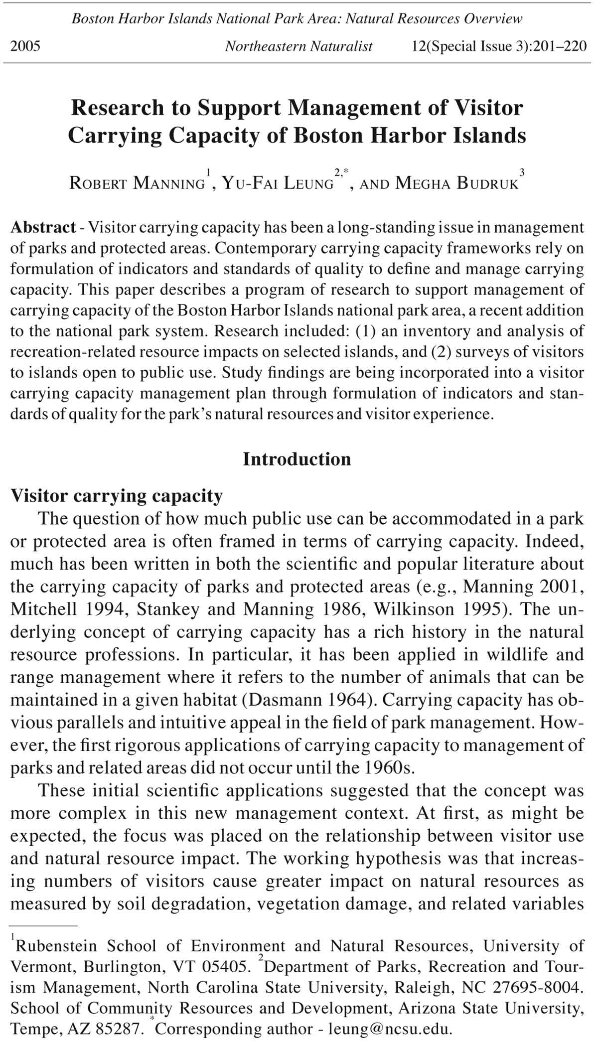
As illustrated in Figure 1, two hypothetical relationships between visitor
use and natural resource and social impacts (represented by line A and
curve B) show that visitor use and impacts are related: increasing amount
of use causes increasing impact. However, it is not clear at what point carrying
capacity has been reached. The hypothetical relationships in Figure
1 suggest that some impact is inevitable, given even relatively low levels
of visitor use. Thus, some level of impact must be tolerated if parks and
related areas are to remain open for public use. For the relationship defined
by line A, X
1
and X
2
represent levels of visitor use that result in differing
levels of impact as defined by points Y
1
and Y
2
, respectively. But which
of these points—Y
1
or Y
2
, or some other point along this axis—represents
the maximum amount of impact that is acceptable? Again, the difficulty in
2005 R. Manning, Y.-F. Leung, and M. Budruk 203
carrying capacity determination lies in deciding how much impact is acceptable.
Empirical relationships such as those in Figure 1 can be helpful
in making informed decisions about carrying capacity, but they must be
supplemented with other information.
To determine acceptable levels of visitor carrying capacity, some
have suggested distinguishing between descriptive and evaluative (or
prescriptive) components of carrying capacity (Shelby and Heberlein
1984, 1986). The descriptive component focuses on factual, objective
data such as the types of relationships in Figure 1. For example, what is
the relationship between the number of visitors entering a park and the
number of encounters that occur among groups of visitors? Or what is
the relationship between the level of visitor use and visitor perceptions
of crowding? The evaluative or prescriptive component of carrying
capacity determination concerns the seemingly more subjective issue
of how much impact or change in resource conditions and the quality of
the visitor experience is acceptable. For example, how many contacts
between visitor groups are acceptable? What level of perceived crowding
should be allowed before management intervention is needed?
Recent experience with carrying capacity suggests that answers to the
above questions can be found through formulation of management objectives
and development of associated indicators and standards of quality
(Belnap 1998; Graefe et al. 1990; Manning 1997, 1998, 2001; Manning et
Figure 1. Hypothetical relationships between visitor use and ecological and
social impacts.
XX11 X2
204 Northeastern Naturalist Vol. 12, Special Issue 3
al. 1998; National Park Service 1997; Stankey et al. 1985). This approach
to carrying capacity puts principal emphasis on defining the degree of
resource protection and the type of visitor experience to be provided and
maintained, monitoring conditions over time, and adopting management
practices to ensure that acceptable conditions have been maintained.
Management objectives are broad, narrative statements that define
the degree of resource protection and the type of visitor experience to
be provided. They are based on the purpose and significance of the area
under consideration. Indicators of quality are measurable, manageable
variables that reflect the essence or meaning of management objectives;
they are quantifiable proxies or measures of management objectives.
Indicators of quality may include elements of both the natural and social
environments. Standards of quality define the minimum acceptable
condition of indicator variables.
Examples of management objectives and indicators and standards of
quality may be helpful. Review of the US Wilderness Act of 1964 suggests
that areas of the national wilderness preservation system are to be managed
to provide opportunities for visitor solitude. Thus, providing opportunities
for solitude is an appropriate management objective for most wilderness
areas. Moreover, research on wilderness use suggests that the number of
visitors encountered along trails and at campsites is important to wilderness
visitors in defining solitude. Thus, trail and camp encounters may be
good indicators of quality and help to make the general management objective
of solitude more operational. Further research suggests that wilderness
visitors may have normative standards about how many trail and camp encounters
are acceptable before the quality of the visitor experience declines
to an unacceptable degree (Heberlein et al. 1986; Lewis et al. 1996;
Manning et al. 1996a, 1996b, 1999; Roggenbuck et al. 1991; Shelby and
Vaske 1991; Vaske et al. 1986; Whittaker and Shelby 1988). Such data may
help define standards of quality. A similar example for the natural resource
component of carrying capacity relates to the wilderness management
objective of preserving ecological conditions. Research on the ecological
impacts of recreation suggests that destruction of ground cover vegetation
and compaction of soil is a common impact of recreation at wilderness
campsites (Hammitt and Cole 1998, Leung and Marion 2000). Therefore,
bare soil exposure at campsites may be a good indicator of resource quality.
The selection of a standard of quality in this case is guided primarily by
visitor impact research, but is also influenced by social science research,
particularly on the effect of resource impacts on the quality of the visitor
experience (Shelby et al. 1988).
While the above examples of management objectives and associated
indicators and standards of quality apply to wilderness areas, recent
studies have extended this research and management approach to a variety
of more developed parks and related areas (Manning et al. 2002,
2003). Research at Boston Harbor Islands was designed to further extend
this work.
2005 R. Manning, Y.-F. Leung, and M. Budruk 205
By defining indicators and standards of quality, carrying capacity
can be determined and managed through an associated program of
monitoring and management. Indicators of quality can be monitored
and management actions taken to ensure that standards of quality are
maintained. If monitoring suggests that standards of quality have been
violated (or may soon be violated), then carrying capacity has been
exceeded and management actions (such as modifying type and amount
of use, visitor education or regulation) may be required. This basic
approach to carrying capacity is central to contemporary park and protected
area management frameworks, including Limits of Acceptable
Change (LAC) (Stankey et al. 1985), Visitor Impact Management (VIM)
(Graefe et al. 1990), and Visitor Experience and Resource Protection
(VERP) (Manning 2001, National Park Service 1997).
Application to Boston Harbor Islands
The concept of carrying capacity was applied to Boston Harbor Islands
national park area through a program of research and planning. This program
included three components: (1) natural science research, (2) social
science research, and (3) preparation of a carrying capacity plan incorporating
research findings. In keeping with the contemporary approach to
carrying capacity described above, this program of research and planning
was directed at formulating a series of indicators and standards of quality
for park resources and the visitor experience.
The natural resources of the national park area and its cooperative
administration are described elsewhere in this issue. Visitation to the
park has been increasing due to its growing popularity among local communities,
improved transportation, and promotion by the Boston Harbor
Islands Partnership. In 2002, the park recorded 262,000 recreational
visits (Boston Harbor Islands Partnership, unpubl. data).
Methods
Natural science research
This component of research focused on identifying and developing
resource-based indicators of quality (or resource impact indicators) and
related monitoring procedures as well as assisting in the formulation of
standards of quality for selected indicator variables. Major research activities
included identification of potential indicators from various sources,
inventory and condition assessment of trails and recreation sites in 2001,
evaluation of other ecological indicators of quality in 2002, and evaluation
and selection of indicator variables in 2003.
First, official and unofficial sites and trails were identified. Official
sites and trails are those designated and clearly identified by the management
agency, while unofficial sites and trails (also referred to as social
trails) are visitor-created and are not identified by the management agency.
While locations of all official recreation sites were known, unofficial sites
206 Northeastern Naturalist Vol. 12, Special Issue 3
were searched extensively on all islands subject to public use as suggested
by park staff and local experts. For official and unofficial recreation sites,
a multiple-indicator assessment approach was adopted (Cole 1989, Leung
and Marion 2000, Marion 1991, Marion and Leung 1997). The procedures
began with a delineation of recreation site boundaries within which impact
indicators were assessed. Inventory information, including GPS coordinates,
site position on landscape, distance to water, distance to trail, and
vegetation canopy cover, were quantified. Impact indicators assessed included
a five-point condition class rating, area of disturbance based on site
size measurement, vegetative groundcover on-site and at off-site controls,
mineral soil exposure, tree damage (three categories), root exposure, trash,
human waste, and vandalism parameters. A simplified version of the assessment
procedures was applied to rest/viewing areas which are usually
small with only benches or no formal facilities.
For condition assessment of official trails an integrated approach was
adopted, combining sampling-based point measurements and a census of
problem events (Leung and Marion 1999, Marion and Leung 2001). Assessments
were conducted for the entire length of each trail segment under
study. Field staff pushed a measuring wheel along the trail while stopping
every 60.6 m (200 ft) to perform point-based measurements such as width,
incision depth, and tread substrate composition. Field staff also documented
each occurrence of pre-defined problem events such as excessive
soil erosion, root exposure, and muddy soil. A more rapid approach was
adopted for social trails, on which only length and overall condition rating
were collected (Cole et al. 1997, Leung et al. 2002).
A series of field measurements was conducted in the summer of 2002
to evaluate additional ecological indicators commonly used in recreation
ecology research (Hammitt and Cole 1998, Leung and Marion 2000).
Quadrat-based and continuous line-transect measurements were applied
within twelve circular sampling plots on Georges, Peddocks, and Grape Islands,
six of which were indicative of high-use areas and the other six representing
relatively low-use areas. Initial measurements were conducted in
June 2002, with remeasurements performed in August and October 2002.
Major ecological indicators assessed included percent cover of ground
vegetation, plant litter and exposed soil, soil compaction as measured by
penetration resistance (Lowery and Morrison 2002), and soil stability as
measured by the slake test in which soil aggregates/fragments are subject
to rapid wetting cycles (Doran and Jones 1996).
Results from site/trail assessments and ecological indicator evaluations
provide the baseline data for the park, and they were utilized
to inform selection of resource-based indicators of quality based on
criteria developed in previous carrying capacity research (Belnap 1998,
GYWVU 1999) and the park’s specific concerns. Monitoring protocols
were also developed for the selected indicator variables.
2005 R. Manning, Y.-F. Leung, and M. Budruk 207
Social science research
Social science research included two surveys of park visitors. The
first survey was designed to identify potential indicators of quality of
the visitor experience. In summer 2000, randomly selected park visitors
returning on ferries from the islands, were administered a questionnaire
that included a series of questions on what they enjoyed most and least
during their visit to Boston Harbor Islands. Following this series of
questions, respondents were asked to judge the degree to which a series
of issues (e.g., crowding, litter) were problems at the park. The survey
resulted in 695 completed questionnaires.
The second survey, conducted in summer 2001, was designed to
measure normative standards of quality of visitors for selected indicator
variables. Norms in parks and outdoor recreation are generally defined as
standards that individuals and groups use for evaluating behavior and social
and environmental conditions (Donnelly et al. 1992, Shelby and Vaske
1991, Vaske et al. 1986). If visitors have normative standards concerning
relevant aspects of park conditions and recreation experiences, then such
norms can be studied and used as a basis for formulating standards of quality.
Developed in sociology, normative theory and methods have attracted
considerable attention as an organizing concept in park and outdoor recreation
research and management. In particular, normative research has
special application in helping to formulate standards of quality for both
resource and social conditions in parks and related areas.
Application of norms to standards of quality is most fully described
by Shelby and Heberlein (1986), Vaske et al. (1986), and Manning
(1999), with these applications relying on the work of Jackson (1965),
who developed a methodology to measure norms. Using these methods,
the personal norms of individuals can be aggregated to determine social
norms. Normative research has focused largely on the issue of crowding
(e.g., Heberlein et al. 1986; Manning et al. 1996a, 1996b, 1998; Patterson
and Hammitt 1990; Shelby 1981; Vaske et al. 1986; Williams et
al. 1991; Whittaker and Shelby 1988), but also has been expanded to include
other potential indicators of quality, including ecological impacts
at campsites (Shelby et al. 1988).
Traditionally, norms have been measured through a numerical approach.
For example, respondents are asked to evaluate the acceptability
of alternative use levels, such as zero, five, or ten encounters with other
groups per day along trails. Resulting data are aggregated to determine
social norms. More recently, visual approaches to measuring norms
have been developed (Hof et al. 1994; Manning et al. 1995, 1996a,
1996b). In this technique, computer software is used to manipulate
photographs to depict alternative use levels and associated resource and
social impacts.
Both numerical and visual approaches to norm measurement were
incorporated into questionnaires administered to random samples of
208 Northeastern Naturalist Vol. 12, Special Issue 3
Figure 2. Frequency distribution and descriptive statistics for site size (area of
disturbance) of official recreation sites.
visitors to the seven islands where visitor services were provided in the
summer of 2001. The survey resulted in 724 completed questionnaires.
Results
Natural science research
Field assessment procedures of potential recreation site and trail impact
indicators were developed and applied to 22 islands (and former islands)
with established or possible recreational use. A total of 144 sites were assessed
in 2001, including 82 official picnic or camping sites, 21 unofficial
recreation sites, and 41 rest/viewing areas. The majority of recreation sites
had modest site size or area of disturbance (Fig. 2). Official sites contributed
to more than 90% of the cumulative area of disturbance (46,680 m2 or
4.7 ha; 11.5 acres) for the entire park. There were several very extensive
official sites on Georges, Lovell, and Bumpkin Islands, with the largest
one being 6970 m2 in size. Unofficial sites, most of which were created
for overnight use, were generally small, ranging from 16 to 265 m2 with
a median of 49 m2. A limited number of large official sites may be necessary
on public use islands to support high levels of use with large groups.
These sites, if appropriately located and maintained, are not generally
considered an unacceptable resource impact issue unless they show signs
of inappropriate degradation as indicated by site expansion, excessive loss
Site Size (m2)
Official Recreation Sites (%)
Mean = 531; median = 92; S.D. = 1191; min. = 14; max. = 7061; N = 82
*(No. of sites, cumalitve frequency)
2005 R. Manning, Y.-F. Leung, and M. Budruk 209
Table 1. Assessment results of unpaved official park trails on the Boston Harbor Islands.
Trail resource No. of % of trails Length of problem segment (m)
impact occurrences surveyed++ Mean Min. Max. Std.Dev. Sum
Bare patches* 5 1.90 11.9 2.7 21.8 8.3 59.4
Soil erosion+ 15 1.92 24.8 1.5 82.1 27.3 372.1
Root exposure 10 0.56 10.8 5.5 21.2 6.1 107.9
Muddy soil 12 0.28 4.5 1.5 7.3 1.9 54.5
*On grassy trails of Grape and Great Brewster Islands only (total length of trails surveyed
= 3126 m).
+Recordable incidents are defined as trail segments that are incised more than 0.3 m (1 ft)
for at least 3 m (10 ft) in length.
++Total length of unpaved official trails surveyed was 19,422 m.
of groundcover vegetation, and increased soil exposure. The existence
and size of unofficial sites, however, is indicative of unacceptable visitorinduced
resource impacts that require management attention.
Mineral soil exposure appears to be more pronounced on unofficial
recreation sites, with about 30% of unofficial sites exhibiting
63% or more exposed soil on site. This indicates a potential impact
concern to natural resources associated with soil degradation and
specifically soil erosion. In contrast, about 30% of official sites had
38% or more exposed soil. However, when the areal extent of soil exposure
was considered (recreation site size x percent soil exposure),
official sites exhibited more cumulative impact with a total of 4288
m2 of exposed soil while the sum of unofficial sites was only 632
m2. Damage to tree trunks was found to be more common on official
recreation sites than their unofficial counterparts. The typical official
site has two damaged trees (median value), with just one damaged
tree on the typical unofficial site.
A total of 91 official trails (30 km) and about 36 km of visitorcreated
social trails were identified and assessed in 2001. Results
suggest that soil erosion, root exposure, and other resource impacts
existed on unpaved park trails, but the extent of these problems was
limited (Table 1). For example, the cumulative length of eroded trail
treads amounted to 372 m, which was only 1.92% of total length of
trails surveyed. Despite this, several soil erosion and root exposure
segments were rather long and they may have compromised the trail’s
transportation function and visitor experience. The density of social
trails was highest on Worlds End with 209 meters per hectare of unit
area (277 feet per acre), followed by Georges (170 m/ha; 226 ft/ac)
and Raccoon (154 m/ha; 204 ft/ac) Islands. High densities of social
trails may suggest proliferation of unmanaged recreational trampling
with potential threats to sensitive habitats.
Spatial proximity of social trails and unofficial sites to sensitive
habitats was evaluated using geographic information systems. Field
210 Northeastern Naturalist Vol. 12, Special Issue 3
researchers identified 141 m of social trails and three unofficial sites
within 50 m of known habitats of rare, threatened and endangered species,
including the seabeach dock plant (Rumex pallidus Lesson), Least
Tern (Sterna antillarum Bigelow), and Barn Owl (Tyto alba L.).
Findings of the 2002 assessment exhibited a considerable variability
in soil compaction and ground cover measurements, while soil
stability (slake test) measurements showed considerable homogeneity
among sampling sites, indicating non-responsiveness to visitor use.
The degree of soil compaction, as measured by penetration resistance,
at Boston Harbor Islands was less pronounced than that reported in
previous impact studies in the East (Marion and Cole 1996). This
may be partly attributed to higher background soil compaction levels,
which are in turn influenced by glacial parent materials and a long
history of human activities on these islands. The average penetration
resistance (pocket penetrometer) values ranged from 1.5 kg/cm2 on
Grape Island to 3.0 kg/cm2 on Georges Island. Soil compaction was
higher on use areas than off-site controls, with penetration resistance
increased by 53% on Georges Island’s low use plots and by 144% on
Grape Island’s low use plots.
Social science research
The first visitor survey identified seven potential indicators of quality:
number of people-at-one-time (PAOT) at selected attraction sites,
number of groups encountered per hour while hiking, environmental
impacts to trails, environmental impacts to campsites, amount of litter,
amount of graffiti, and amount and quality of information about the
park. These variables are related to both the resource and social conditions
of the park and were reported by visitors as important in determining
the quality of the visitor experience.
The second visitor survey identified a range of potential standards of
quality for these seven indicator variables. Two of these indicator variables
will be used to illustrate study findings: visitors to Little Brewster
Island were asked to judge the acceptability of a series of five computeredited
photographs showing a range of visitors to the island (Fig. 3), and
visitors who camped on Bumpkin and Grape Islands were asked to judge
the acceptability of a series of five computer-edited photographs showing
a range of ecological impact at a representative campsite (Fig. 4).
For the Little Brewster Island photos, the response scale was
anchored at -4 (“very unacceptable”) and +4 (“very acceptable”).
The mean response for the sample as a whole for each photograph is
graphed in Figure 5 and results in a “social norm curve.” The point at
which the social norm curve crosses the neutral point of the response
scale (approximately 95 PAOT) represents an “acceptability”-based
standard of quality, as this is the minimum level of acceptability for
PAOT for most respondents.
2005 R. Manning, Y.-F. Leung, and M. Budruk 211
Figure 3. Study photographs of people-
at-one-time (PAOT) at Little
Brewster Island.
Figure 4. Study photographs of
campsite impacts at Bumpkin and
Grape Islands.
1
2
3
4
5
1
2
3
4
5
212 Northeastern Naturalist Vol. 12, Special Issue 3
Table 2. Summary of PAOT study findings for Little Brewster Island.
Standards of quality N Mean PAOT
Preference 107 49
Acceptability 107 72
Management action 103 89
Displacement 103 174
Existing conditions 101 47
Figure 6. Social norm curves for campsite impacts at Bumpkin and Grape Islands.
Figure 5. Social norm curve for people-at-one-time (PAOT) on Little Brewster
Island.
Table 3. Summary of campsite impact study findings for Bumpkin and Grape Islands.
Bumpkin Island Grape Island
Standards of quality N Mean photo number N Mean photo number
Preference 32 1.4 37 1.4
Acceptability 33 3.2 33 3.0
Management action 33 2.8 35 2.7
Displacement 33 4.0 35 4.4
Existing conditions 28 1.8 34 1.9
PAOT in photographs
2005 R. Manning, Y.-F. Leung, and M. Budruk 213
Respondents were also asked to select the photograph that best
represented (1) the PAOT condition they preferred (“preference”-
based standard of quality), (2) the PAOT condition that was so
unacceptable that they would no longer visit Little Brewster Island
(“displacement”-based standard of quality), (3) the maximum PAOT
condition they thought the National Park Service should allow before
restricting visitor use (“management action”-based standard of quality),
and (4) the PAOT condition they experienced on the day of their
visit (“existing conditions”). All standards of quality findings are
summarized in Table 2 and provide an empirical basis for selecting
PAOT standards of quality for the island.
For the Bumpkin and Grape Islands campsite photographs, the same
response scale as described above was used. The points at which these
social norm curves cross the neutral point of the response scale (mean
response values of approximately photo number 3.2 for Bumpkin Island
and photo number 3.0 for Grape Island) represent “acceptability” based
standards of quality (Fig. 6). “Preference,” “displacement,” “management
action,” and “existing conditions” questions were also asked as
described above, and all standards of quality findings are summarized in
Table 3, providing an empirical basis for selecting standards of quality
for ecological impacts at park campsites.
Discussion
Planning component
After completion of the natural and social science research components,
a series of planning workshops were held in the winter and spring
of 2003 to formulate indicators and standards of quality for the park.
Workshop participants included the planning committee of the Boston
Harbor Islands Partnership and research staff, including principal investigators
and graduate students. The workshops were facilitated by the
park assistant superintendent.
The National Park Service, in conjunction with the Boston Harbor
Islands Partnership, recently completed a general management plan
(GMP) to guide park management (National Park Service 2002). This
plan established six zones into which all park lands are assigned. The
management objectives for each of the zones provided initial guidance
concerning appropriate indicators and standards of quality for
natural and social conditions. Study findings from the natural and social
science research provided a more empirical basis for formulating
indicators and standards.
For example, management objectives developed in the park’s GMP
specified that the Natural Features Emphasis zone of the park would provide
opportunities for visitor solitude, while the Visitor Services and Park
Facilities Emphasis zone would provide opportunities for a more social
214 Northeastern Naturalist Vol. 12, Special Issue 3
experience. Study findings from the social science data outlined a range
of potential standards of quality for visitor density (from “preference” to
“displacement”), including PAOT at attraction sites and encounters along
trails. For the Natural Features Emphasis zone (emphasizing solitude), a
standard of quality near the preference end of the range was selected (to
ensure high levels of solitude), while a standard of quality near the management
action or displacement end of the range was selected (because
solitude is not important in this area)for the Visitor Services and Park Facilities
Emphasis zone (emphasizing a social experience).
Findings of the natural science component of the study were also
utilized in the formulation of standards of quality. Frequency distribution
charts and tables of impact indicators were provided to the planning
committee in order to determine the level at which a realistic standard
of quality can be set given the current levels of resource impact. For
instance, previous research has shown that soil erosion rates were substantial:
beyond 20–30% of mineral soil exposure on the ground (Kuss
and Morgan 1984, 1986). The planning committee eventually selected
the lower end of 20% as the standard. This decision was informed by
the body of visitor impact research and the current resource conditions
which indicate that only a minority of sites would exceed this standard
and require corrective management actions.
A third example involves both natural and social science research
findings. Natural science research found that visitors were causing
impacts at campsites through destruction of ground cover vegetation
and resulting sheet erosion of exposed bare soil. From an ecological
standpoint, this process can lead to degradation of the park’s natural
condition. However, natural science data provides only a partial picture
to suggest an appropriate standard of quality for this indicator variable.
Social science data may complement natural science data by suggesting
a standard of quality for campsite condition from an aesthetic standpoint
based on visitors’ perceptions. The social science findings described earlier
for Bumpkin and Grape Islands suggest the point at which campsite
impacts are judged as unacceptable, and these data can be used to help
set a socially acceptable standard of quality for the ecological indicator
variable of campsite impacts.
Workshop sessions resulted in sets of resource and social indicators
and standards of quality for each zone on each island. These indicators
and standards of quality are designed to meet the management
objectives for each zone as defined in the GMP and to provide for an
appropriate range of resource conditions and visitor opportunities
throughout the park. Indicators and standards of quality that were selected
are summarized in Table 4. Indicators and standards of quality
for the social science component were recommended for only those
islands open to public access in 2001.
2005 R. Manning, Y.-F. Leung, and M. Budruk 215
Table 4. Selected indicators and standards of quality for visitor carrying capacity on the Boston Harbor Islands (the notation “-” means not recommended
as an indicator for the island).
Eroded
Official picnic
Density Area Quality of Amount of
People Tour Trail tread on
sites & campsites
of disturbed information information
at one group encounters official Campsite Bare soil social unofficial (% visitors (% of visitors
Management Zone time size (hikers/ trails impacts exposure Litter Graffiti trails recreation who have who have
and Islands (photo #) (photo #) hour) (ft2) (photo #) (%) (photo #) (photo #) (ft/acre) sites (ft2) quality info) adequate info)
Natural Features Emphasis - - - - - - 1–2 2 10 0 - -
(Button, Calf, Green, Hangman,
Langlee, Little Calf, Middle
Brewster, Outer Brewster, Raccoon,
Ragged, Sarah, Shag Rocks,
Sheep, Slate, Snake)
Managed Landscape Emphasis - - 5–15 50 a 20 1–2 2 10 0 75 a
(Bumpkin, Gallops, Grape,
Great Brewster, Webb Memorial Park,
Worlds End, Rainsford)
Historic Preservation Emphasis 60b 30b - - - 20 1–2 2b 10b 0b 75b a
(Little Brewster, The Graves)
Multiple Management Emphasis 185–200c 30 15–25 - 20 1–2 2 10–50 0 75 a
(Deer, Georges, Long, Lovells,
Moon, Nut, Peddocks, Spectacle,
Thompson)
Special Use Emphasis - - - - - - 1–2 2 - - - -
(Nixes Mate)
aApplicable to public use islands only
b(Little Brewster only)
c(Georges and Long only)
216 Northeastern Naturalist Vol. 12, Special Issue 3
Conclusions
An integrated program of natural and social science research
and associated planning was conducted at Boston Harbor Islands
national park area to manage visitor carrying capacity. Contemporary
approaches to carrying capacity emphasize the importance of
formulating indicators and standards of quality that define minimum
acceptable resource and social conditions in the park. This process
entails a long-term commitment to monitoring indicator variables,
and implementation of management actions to ensure that standards
of quality are maintained. Management actions designed to control
and/or reduce the resource and social impacts of visitor use include
education on low-impact visitor behavior, hardening and maintenance
of visitor use areas, and, ultimately, limiting visitor use. The research
and planning process used at Boston Harbor Islands national park
area provides an empirical, scientific basis for justifying implementation
of such management actions, protecting the quality of park
resources and the visitor experience, and managing the park within a
defined visitor carrying capacity.
A carrying capacity–related monitoring program for Boston Harbor
Islands is now being designed and will focus on the indicators of
quality outlined in Table 4. When and where monitoring data suggest
that standards of quality are in danger of being violated, management
action will be undertaken. For example, if visitor density or natural
resource impact standards of quality are violated, adjustments can be
made to ferry schedules so that fewer visitors are delivered to islands
experiencing these problems or so that visitation can be temporally or
spatially shifted.
Experience at Boston Harbor Islands clearly demonstrates that
carrying capacity has both resource and social dimensions, and that
there can be a strong relationship between these dimensions. Visitor
use of parks such as Boston Harbor Islands can impact both the
natural resources of the park and the quality of the visitor experience.
Moreover, resource impacts can also affect the quality of the visitor
experience, and these aesthetic impacts can offer a potentially important
justification and guidance for setting standards of quality. Carrying
capacity analysis and management requires an integrated program
of natural and social science research.
The program of research outlined in this paper provides an important
scientific basis for managing carrying capacity. Carrying capacity also
requires the exercise of management judgment. For example, the natural
and social science research outlined in this paper offers an empirically
based range of potential standards of quality for selected indicator variables.
However, selection of a standard of quality requires some element
2005 R. Manning, Y.-F. Leung, and M. Budruk 217
of management judgment. But such judgments should be as scientifi-
cally informed as possible (Manning and Lawson 2002).
Literature Cited
Belnap, J. 1998. Choosing indicators of natural resource condition: A case study in
Arches National Park, Utah, USA. Environmental Management 22:635–642.
Cole, D.N. 1989. Wilderness campsite monitoring methods: A sourcebook.
General Technical Report INT-259. USDA Forest Service, Intermountain
Research Station, Ogden, UT. 57 pp.
Cole, D.N., A.E. Watson, T.E. Hall, and D.R. Spildie. 1997. High-use destinations
in wilderness: Social and biophysical impacts, visitor responses, and
management options. Research Paper INT-RP-496. USDA Forest Service,
Intermountain Research Station, Ogden, UT. 30 pp.
Dasmann, R. 1964. Wildlife Biology. John Wiley and Sons, New York, NY. 231 pp.
Donnelly, M.P., J.J. Vaske, and B. Shelby. 1992. Measuring backcountry standards
in visitor surveys. Pp. 38–52, In B. Shelby, G.H. Stankey, and B.
Shindler (Eds.). Defining Wilderness Quality: The Role of Standards in
Wilderness Management—A Workshop Proceedings. General Technical
Report PNW-GTR-305. USDA Forest Service, Pacific Northwest Research
Station.
Doran, J.W., and A.J. Jones. 1996. Methods for Assessing Soil Quality. Soil
Science Society of America, Madison, WI. 410 pp.
Frissell, S., and G. Stankey. 1972. Wilderness environmental quality: Search for
social and ecological harmony. Pp. 170–83, In Proceedings of the Society
of American Foresters Annual Conference. Society of American Foresters,
Hot Springs, AR.
Graefe, A., J. Vaske, and F. Kuss. 1984. Social carrying capacity: An integration
and synthesis of twenty years of research. Leisure Sciences
6:395–431.
Graefe, A., F. Kuss, and J. Vaske. 1990. Visitor Impact Management: The Planning
Framework. National Parks and Conservation Association, Washington,
DC. 105 pp.
GYWVU (Greater Yellowstone Winter Visitor Use Management Working
Group). 1999. Winter visitor use management: A multi-agency assessment.
Final report of information for coordinating winter recreation in
the Greater Yellowstone Area. USDI National Park Service, Jackson, WY.
100 pp.
Haas, G. 2001. Visitor capacity in the National Park System. Social Science
Research Review (Volume 2, Number 1). US National Park Service, Social
Science Program, Washington, DC. 28 pp.
Hammitt, W.E., and D.N. Cole. 1998. Wildland Recreation: Ecology and Management
(2nd Edition). John Wiley and Sons, New York, NY. 361 pp.
Heberlein, T., G. Alfano, and L. Ervin. 1986. Using a social carrying capacity
model to estimate the effects of marina development at the Apostle Islands
National Lakeshore. Leisure Sciences 8:257–74.
Hof, M., J. Hammitt, M. Rees, J. Belnap, N. Poe, D. Lime, and R. Manning.
1994. Getting a handle on visitor carrying capacity: A pilot project at Arches
National Park. Park Science 14:11–13.
218 Northeastern Naturalist Vol. 12, Special Issue 3
Jackson, J. 1965. Structural characteristics of norms. Pp. 301–309, In I.D.
Steiner, and M.F. Fishbein (Eds.). Current Studies of Social Psychology.
Holt, Rinehart, Winston, New York, NY.
Kuss, F.R., and J.M. Morgan III. 1984. Using the USLE to estimate the physical
carrying capacity of natural areas for outdoor recreation planning. Journal
of Soil and Water Conservation 39:383–387.
Kuss, F.R., and J.M. Morgan III. 1986. A first alternative for estimating the
physical carrying capacities of natural areas for recreation. Environmental
Management 10:255–262.
Kuss, F., A. Graefe, and J. Vaske. 1990. Visitor Impact Management: A Review
of Research. National Parks and Conservation Association, Washington,
DC. 256 pp.
Leung, Y.-F., and J.L. Marion. 1999. Characterizing backcountry camping impacts
in Great Smoky Mountains National Park, USA. Journal of Environmental
Management 57:193–203.
Leung, Y.-F., and J.L. Marion. 2000. Recreation impacts and management in
wilderness: A state-of-knowledge review. Pp. 23–48, In D.N. Cole, S.F. Mc-
Cool, W.T. Borrie, and J. O’Loughlin (Compilers). Wilderness Science in a
Time of Change Conference—Volume 5: Wilderness Ecosystems, Threats,
and Management; Missoula, MT. Proceedings RMRS-P-15-VOL-5. USDA
Forest Service, Rocky Mountain Research Station, Ogden, UT.
Leung, Y.-F., N. Shaw, K. Johnson, and R. Duhaime. 2002. More than a database:
Integrating GIS data with the Boston Harbor Islands carrying capacity
study. The George Wright Forum 19(1):69–78.
Lewis, M., D. Lime, and P. Anderson. 1996. Paddle canoeists encounter norms
in Minnesota’s Boundary Waters Canoe Area Wilderness. Leisure Sciences
23:1–13.
Lime, D., and G. Stankey. 1971. Carrying capacity: Maintaining outdoor recreation
quality. Pp. 174–84, In E.H. Larson (Ed.). Recreation Symposium
Proceedings. US Forest Service, Upper Darby, PA.
Lowery, B., and J.E. Morrison, Jr. 2002. Soil penetrometers and penetrability.
Pp. 363–88, In J. Dane, and C. Topp (Eds.). Methods of Soil Analysis. Part
4—Physical Methods. Soil Science Society of America, Madison, WI.
Manning, R. 1985. Crowding norms in backcountry settings: A review and synthesis.
Journal of Leisure Research 17:75–89.
Manning, R. 1997. Social carrying capacity of parks and outdoor recreation
areas. Parks and Recreation 32:32–8.
Manning, R. 1998. “To provide for the enjoyment”: Recreation management in
the national parks. The George Wright Forum 15(1):6–20.
Manning, R. 1999. Studies in Outdoor Recreation (2nd Edition). Oregon State
University Press, Corvallis, OR. 384 pp.
Manning, R. 2001. Visitor experience and resource protection: A framework
for managing the carrying capacity of National Parks. Journal of Park and
Recreation Administration 19(1):93–108.
Manning, R., and S. Lawson. 2002. Carrying capacity as “informed judgment”:
The values of science and the science of values. Environmental Management
30:157–168.
Manning, R., D. Lime, W. Freimund, and D. Pitt. 1996a. Crowding norms at
frontcountry sites: A visual approach to setting standards of quality. Leisure
Sciences 18:39–59.
2005 R. Manning, Y.-F. Leung, and M. Budruk 219
Manning, R., D. Lime, and M. Hof. 1996b. Social carrying capacity of natural
areas: Theory and application in the US national parks. Natural Areas Journal
16:118–27.
Manning, R., D. Lime, M. Hof, and W. Freimund. 1995. The Visitor Experience
and Resource Protection Process: The application of carrying capacity to
Arches National Park. The George Wright Forum 12:41–55.
Manning, R., C. Jacobi, W. Valliere, and B. Wang. 1998. Standards of quality in
parks and recreation. Parks and Recreation 33:88–94.
Manning, R., W. Valliere, B. Wang, and C. Jacobi. 1999. Crowding norms: Alternative
measurement approaches. Leisure Sciences 21:97–115.
Manning, R., W. Valliere, B. Wang, S. Lawson, and P. Newman. 2003. Estimating
day use social carrying capacity in Yosemite National Park. Leisure: The
Journal of the Canadian Association for Leisure Studies 27 (1–2): 77–102.
Manning, R., B. Wang, W. Valliere, S. Lawson, P. Newman. 2002. Research
to estimate and manage carrying capacity of a tourist attraction: A study of
Alcatraz Island. Journal of Sustainable Tourism 10: 388–464.
Marion, J.L. 1991. Developing a natural resource inventory and monitoring
program for visitor impacts on recreation sites: a procedural manual. Natural
Resources Report NPS/NRVT/NRR-91/06. USDI National Park Service,
Natural Resources Publication Office, Denver, CO. 59 pp.
Marion, J.L., and D.N. Cole. 1996. Spatial and temporal variation in soil and
vegetation impacts on campsites. Ecological Applications 6:520–530.
Marion, J.L., and Y.-F. Leung. 1997. An assessment of campsite conditions in
Great Smoky Mountains National Park. Research/Resources Management
Report. USDI National Park Service, Southeast Regional Office, Atlanta,
GA. 135 pp.
Marion, J.L., and Y.-F. Leung. 2001. Trail resource impacts and an examination
of alternative assessment techniques. Journal of Park and Recreation
Administration 19(3):17–37.
Mitchell, J. 1994. Our national parks. National Geographic 186(4):1–55.
National Park Service. 1997. The Visitor Experience and Resource Protection
(VERP) Framework: A Handbook for Planners and Managers. Publication
No. NPS D-1215. USDI National Park Service, Denver Service Center,
Denver, CO. 103 pp.
National Park Service. 2002. Boston Harbor Islands National Recreation Area
Final General Management Plan. USDI National Park Service, Boston Harbor
Islands National Recreation Area, Boston, MA. 152 pp.
Patterson, M., and W. Hammitt. 1990. Backcountry encounter norms, actual
reported encounters, and their relationship to wilderness solitude. Journal of
Leisure Research 22:259–275.
Roggenbuck, J., D. Williams, S. Bange, and D. Dean. 1991. River float trip
encounter norms: Questioning the use of the social norms concept. Journal
of Leisure Research 23:133–53.
Shelby, B. 1981. Encounter norms in backcountry settings: Studies of three rivers.
Journal of Leisure Research 13:129–138.
Shelby, B., and T. Heberlein. 1984. A conceptual framework for carrying capacity
determination. Leisure Sciences 6:433–51.
Shelby, B., and T. Heberlein. 1986. Carrying Capacity in Recreation Settings.
Oregon State University Press, Corvallis, OR. 164 pp.
220 Northeastern Naturalist Vol. 12, Special Issue 3
Shelby, B., and J. Vaske. 1991. Using normative data to develop evaluative standards
for resource management: A comment on three recent papers. Journal
of Leisure Research 23:173–87.
Shelby, B., J. Vaske, and R. Harris. 1988. User standards for ecological impacts
at wilderness campsites. Journal of Leisure Research 20:245–256.
Stankey, G., and D. Lime. 1973. Recreation carrying capacity: An annotated
bibliography. General Technical Report INT-3. USDA Forest Service, Intermountain
Forest and Range Experiment Station. Ogden, UT. 45 pp.
Stankey, G., and R. Manning. 1986. Carrying capacity of recreation settings. Pp.
M47–M57, In A Literature Review: The President’s Commission on Americans
Outdoors. US Government Printing Office, Washington, DC.
Stankey, G., D. Cole, R. Lucas, M. Peterson, S. Frissell, and R. Washburne.
1985. The Limits of Acceptable Change (LAC) system for wilderness planning.
General Technical Report INT-176. USDA Forest Service, Intermountain
Forest and Range Experiment Station, Ogden, UT. 37 pp.
Vaske, J., A. Graefe, B. Shelby, and T. Heberlein. 1986. Backcountry encounter
norms: Theory, method and empirical evidence. Journal of Leisure Research
18:137–53.
Wagar, J. 1964. The carrying capacity of wild lands for recreation. Forest Science
Monograph 7. Society of American Foresters, Washington, DC. 24 pp.
Whittaker, D., and B. Shelby. 1988. Types of norms for recreation impact: Extending
the social norms concept. Journal of Leisure Research 20:261–73.
Wilkinson, T. 1995. Crowd control. National Parks 69(7–8):36–41.
Williams, D., J. Roggenbuck, and S. Bange. 1991. The effect of norm-encounter
compatibility on crowding perceptions, experience, and behavior in river
recreation settings. Journal of Leisure Research 23:154–172.


 The Northeastern Naturalist is a peer-reviewed journal that covers all aspects of natural history within northeastern North America. We welcome research articles, summary review papers, and observational notes.