Northeastern Naturalist
45
L. Brooks
2017 Vol. 24, Special Issue 7
“Every Swamp is a Castle”: Navigating Native Spaces in the
Connecticut River Valley, Winter 1675–1677 and 2005–2015
Lisa Brooks*
Abstract - This essay focuses on the historical and ecological landscape of King Philip’s
War (1675–1678), highlighting 2 spaces in Kwinitekw, the Western Abenaki term for the
Connecticut River Valley, during the harsh winter of 1675–1676. I track the captive Mary
Rowlandson’s journey with the Wampanoag leader Weetamoo through the interior Nipmuc
country and Kwinitekw and discuss the Penacook leader Wanalancet’s winter refuge in
the Kwinitekw headwaters. This paper highlights an indigenous studies methodology of
place-based, experiential research in the land and waterways, in combination with more
traditional historical and literary methodologies. It also demonstrates the importance
of indigenous language and place names in mapping historical contexts, understanding
ecological knowledge, and interpreting the movements of leaders. The paper focuses on
the vast expanse of the Wabanaki country, which is often neglected or misrepresented in
colonial-era histories, and especially the “extensive and varied ‘winterlands’” highlighted
by the scholarship of Thomas Wickman. The essay features maps of areas historically inhabitated
by Native peoples created with ArcGIS by a collaborative team, and highlights
contemporary on-the-ground engagement with these places, the knowledge gained from
reading the archive of the land, and the possibility of understanding of these spaces as vital
ecological and social communities, which have much to teach us today.
Introduction
In August 1675, the Penacook leader Wanalancet led a group of his relations
north, seeking shelter from the colonial war that had recently ripped through the
land. Although he had pledged and maintained neutrality, that had not stopped
the notorious Captain Samuel Mosely from burning houses in Wanalancet’s upriver
town, while Wanalancet restrained his warriors from defending them. (Bodge 1906,
Gookin 1836) Wanalancet found himself in an unbearably difficult position, unable
to fully protect his people, and unwilling to commit himself to participation in an
act of military offense, as some of his Nipmuc and Wampanoag neighbors had done.
It was the beginning of the conflict that New England settlers would later name
“King Philip’s War”, a multifaceted resistance against English colonization whose
effects would reverberate for decades, even centuries, not only on Indigenous
people, but the land which sustained them.
Wanalancet and his relations traveled familiar trails through Penacook country,
up the deep river they called Molôdemak (Merrimack), until they arrived at the
fishing falls at the confluence with the swift current of the Pemigewasset, where
he stayed awhile at Pemijoasek, the village of the same name. A fertile intervale
in the Wawôbadenik (White Mountains), Pemigewasset was far from the colonial
*English Department and American Studies Department, AC #2234, Amherst College, PO
Box 5000, Amherst, MA 01002-5000; lbrooks@amherst.edu.
Manuscript Editor: Jean O’Brien
Winter Ecology: Insights from Biology and History
2017 Northeastern Naturalist 24(Special Issue 7):H45–H80
Northeastern Naturalist
L. Brooks
2017
46
Vol. 24, Special Issue 7
settlements, unknown to settlers, protected by this distance and the forested mountains
that surrounded it. When Wanalancet visited, the people would have been
gathering in the harvest, as frost comes early to this northern intervale, and perhaps
even preparing for the fall hunt. Although Pemigewasset was far beyond the
front of colonial war, the distance did not prevent Wanalancet’s southern relation,
Samuel Numphow, from traveling there on a mission to locate the Penacook leader,
and deliver a message from the Bastoniak governor, John Leverett, the leader of
the “people of Boston” or colonial Massachusetts (Fig. 1; Calloway 1988, Laurent
1884, Numphow 1675, Stewart-Smith 1998).
Yet, by the time Sam Numphow arrived, he reported, Wanalancet and his people
were long gone, headed farther north, even beyond the veritable fortress of the White
Mountains, to the headwaters of the long river Kwinitekw (Connecticut), a place thick
with swamps and boreal forests, well known to Wabanaki families, but far beyond colonial
reach, and even the imagined maps of English men (Fig. 2: Numphow 1675).
Figure 1. Map featuring the Wabanaki country of Wanalancet and Samuel Numphow’s journeys,
highlighting Native territories from the Kennebec River to Lake Champlain. Unless
otherwise noted, all maps were created with ArcGIS by Andy Anderson, Lisa Brooks, and
the “Place of Memory” mapping team (2014–2016): Aida Orozco, Cassandra Hradil, Heru
Craig, Maggie King, Lauren Tuiskula, Allyson LaForge, and Griffin Harris.
Northeastern Naturalist
47
L. Brooks
2017 Vol. 24, Special Issue 7
New England maps of the time reached only to Wiwninbesaki (Lake Winnepesaukee),
nearby Pemigewasset, and the edge of the White Mountains. When
Numphow mentioned Pemigewasset to colonial governors, they would not have
recognized the place name or its location. It is not well known even to modern
scholars. And still, when historians read the Massachusetts magistrate and missionary
Daniel Gookin’s (1674) report that Wanalancet went to the Connecticut
River headwaters, they search for a more known location—a mission village on the
St. Lawrence like Odanak or Sillery, or a known Connecticut River territory, like
Koasek (Calloway 1990, Day 1981, Haefeli and Sweeney 1994). Even those suggestions
are made only by historians who know the Wabanaki country well. Yet for
some contemporary Abenaki people for whom this remains a sanctuary, the “land
of the dead” and beloved north country, it makes great sense that Wanalancet would
find refuge there. This is a place that still today is sought by hunters and fishers,
a sanctuary for Ursus americanus (Pallus) (American Black Bear or awassos),
Alces acles (L.) (Moose or môs), and Castor canadensis Kuhl (American Beaver
or tamakw/amiskw); a coldwater refuge for Salvelinus fontinalis (Mitchill) (Brook
Trout or skotam) and Salmo salar L. (Atlantic Salmon or mskwamakw); a place
where basketmakers traveled over several centuries, leaving material evidence of
Figure 2. “A Map of New-England”, published in William Hubbard’s Narrative of the
Troubles with the Indians… (John Foster, Boston, 1677), with Lake Winnepesaukee and
“the White Hills” centered at the far right. Source: https://commons.wikimedia.org/wiki/
File:Hubbard_map_1677.JPG.
Northeastern Naturalist
L. Brooks
2017
48
Vol. 24, Special Issue 7
their travels for descendants to find. The plants needed by artists, medicine people,
and those who simply seek a good meal, including Vaccinium corymbosum L.
(Blueberry or satamozi) and Hierochloe odorata L. (Sweetgrass or olaskikak), still
flourish. It is easy to remember our ancestors here.
Such cultivated familiarity with place, combined with a capacity to read the
environment or the stories on the land, marks a particular way of simultaneously
engaging history and ecology, an Indigenous methodology marked by dialogue
between the analysis of print and the geography of the land, which is informed
by oral traditions, cultural insight, and traditional ecological knowledge (Basso
1996, Berkes 1999, Bruchac 2003, Denetdale 2007, Justice 2006, Kimmerer 2013,
Silko 1996). In unpacking the complexity of a colonial conflict like King Philip’s
War, members of descendant Native communities have continually engaged, often
through multiple generations, in this dialogue, an ongoing exchange that enables
us to better understand the world of our ancestors and the ways those transformations
and adaptations have shaped the one we now inhabit. The layers of history
beneath our feet have much to tell us, but they also manifest in the growth of trees
and plants, the bend of a river, and the roots and routes of trails that still remain.
Part One: Reading a Captive Trail in the Nipmuc and Sokoki countries
Penacook, Pemigewasset, and the north country headwaters were vital Native
homelands within the vast land still known as Wabanaki, the eastern land, the land of
the dawn (Fig. 3). Today, the term Wabanaki most often includes Penobscot (eastern
Figure 3. Map of the Dawnland, showing Native territories from the neighboring Haudenosaunee
(Iroquois) Confederacy to Penobscot and Passamaquoddy territories on the
Wabanaki coast.
Northeastern Naturalist
49
L. Brooks
2017 Vol. 24, Special Issue 7
Maine), Passamaquoddy (Maine and New Brunswick), Maliseet (Maine and New
Brunswick) and Mi’k maw people (Maine, New Brunswick, and Nova Scotia) , as
well as Abenaki (Southern Quebec, Vermont, New Hampshire, western Maine), a
shortened form of the name for the people of the dawn (Fig. 4). However, the dawnland
is vast, encompassing all of northern New England, part of the southern Quebec,
as well as the Canadian Maritimes. Wampanoag people in southeastern Massachusetts
use a similar word, in their language Wôpanâak , to convey the same identity as
the original people of this eastern land, those whose responsibility it is to greet the sun
as it rises every morning. The Native people of the Ohio Valley in fact referred to all
of their relations on the east coast, from the Maritimes to the Lenape valley, as Wauponnuhk
(Aupaumut 1804). When the people of the east faced extreme challenges,
including war, they could turn to this vast network of relations and places, a strategy
they followed during King Philip’s War and the many conflicts that followed.
Even in tracking the narratives of English captives, which first emerge during this
war and continue through the next century, this network of relations and places is
Figure 4. Map highlighting Wabanaki homelands (and showing, separately, the Kaniekehaka
Mohawk nation of Kahnawake). From The Common Pot: The Recovery of Native Space
in the Northeast (Brooks 2008).
Northeastern Naturalist
L. Brooks
2017
50
Vol. 24, Special Issue 7
evident in a careful reading. These connections can certainly be seen in the foundational
captivity narrative, The Sovereignty and Goodness of God … A Narrative of the
Captivity and Restoration of Mary Rowlandson, which was first published in 1682
and continues to be taught as the first colonial English captivity narrative in American
literature and history classrooms around the country, hailed as one of the first
publications by a woman in New England. The wife of a minister, Mary Rowlandson
was taken captive by an allied group of warriors, who, in February 1675, raided her
town of Lancaster, a western outpost of the Massachusetts Bay colony, which itself
was located in the Nipmuc territory of Nashaway. The raid was led by a local Nashaway
leader named Monoco, seeking the reclamation of this fertile “place between”
rivers from local settlers and the colony of Massachusetts. Shortly after the raid, the
“mistress” Mary Rowlandson was gifted to the Narragansett leader Quinnapin and
his wife, the Wampanoag leader Weetamoo, a formidable diplomat. (Connole 2007;
Jaffee 1999; Morison 1932; Nourse 1884, 1900; Rowlandson and Salisbury 1997)
Rowlandson traveled with Weetamoo through the rest of that cold, deep winter and
into the spring, as Weetamoo and her kin sought refuge beyond English militia
and settlements. Although Rowlandson centered her story on her own travails of
captivity and redemption, Weetamoo’s movements and motivations can be discerned
through close reading of the text and careful tracking on the land.
While Rowlandson characterized her journey as wandering like “one astonished”
through a maze, Weetamoo moved through a familiar territory of trails,
subsistence sites, and gathering places. Tracking these places through multiple
seasons, following and discerning those trails on maps, on foot and by canoe, then
mapping via ArcGIS technology has enabled my research team to create a map,
revealing the Indigenous geographies, through which Rowlandson and Weetamoo
traveled, that lay beneath the captive’s “maze” (Fig. 5).
Nichewaug, crossroad at the “between land”
Traveling on a trail that largely remains a road (Route 22) today, Rowlandson
described trekking through snowy woods to “a desolate place in the Wilderness,
where” she imagined “there were no Wigwams or Inhabitants before” (Rowlandson
and Salisbury 1997:78). In her estimation, this was a location so isolated that
no one had ever lived there, or even encamped there to seek sustenance. Yet, this
place had a name: Nichewaug or “between land”, in part because, as research and
mapping of Native trails has revealed, it was at a crossroads of trails. (Bright 2004,
Coolidge 1948, Leach 1961, Nourse 1903) Although in winter, Nichewaug might
indeed seem a desolate place, with ice-covered ponds and deep marshes revealing
only the tracks of its animal inhabitants, in summer, it is a flourishing swamp, a
place that Abenaki educator and basketmaker Judy Dow would call an Indigenous
“supermarket”. Indeed, the Nipmuc (freshwater, interior) people with whom Rowlandson
traveled would have known this place because of the bounty of fish and
edible and medicinal plants that it provided to them during the spring and summer
(Fig. 6).
I visited this place, with my family and then with my students, during those
summer months, walking the trails through the state forest and reservoir that now
Northeastern Naturalist
51
L. Brooks
2017 Vol. 24, Special Issue 7
Figure 5. Map of Mary Rowlandson’s removes, highlighting the Native trails, towns, and
territories though which she and Weetamoo traveled.
Figure 6. Nichewaug, July 2014. Mary Rowlandson described this bountiful wetland at the
crossroads of Indigenous trails as “a desolate place in the Wilderness”.
Northeastern Naturalist
L. Brooks
2017
52
Vol. 24, Special Issue 7
preserve its wet woodlands. The landscape has been transformed dramatically by
Boston’s demand for water; much of Nichewaug is now covered by the Quabbin
reservoir. Yet the marshes that protected Weetamoo and the families who traveled
with her still characterize this landscape and its ecology. Following these visits, our
research team, including GIS specialist Dr. Andy Anderson, Geology student Aida
Orozco, and American Studies student Cassandra Hradil, mapped the location. We
found that once we put the place name together with the estimated location, discerned
by delving deeply into local histories and historical maps and the network
of historical Native trails, we could see that Nichewaug was a gathering place at the
crossroads of trails, not a random stop in an uninhabited and unmapped wilderness.
Further, by traveling to the place, students, who already were deeply immersed
in mapping, could learn Native geography and ecology experientially—seeing,
smelling, and hearing the mid-summer activity of the swamp. Indeed, they experienced
Nichewaug as an idyllic sanctuary. This outlook represented a longstanding
cultural shift in the perception and characterization of wetlands, to be sure, whereby
wilderness and swamps have transformed to cherished wetlands. Yet it was also a
recognition of the place’s identity, one recognized for thousands of years by Indigenous
people, as a nourishing bowl of interconnected activities, fostered by the
many beings who call it home.
Every swamp is a castle
One of the many insights revealed by mapping Rowlandson and Weetamoo’s
journey is that Native leaders were leading their families from swamp to swamp,
as they aimed to evade colonial militia attempting to track them in the winter
snow. They traveled to the crossroads at Nichewaug not only because it was a
known location, where they might camp, but because its terrain offered natural
protection. Englishmen lacked understanding of the true value of swamps as “ecological
cornucopia”, characterizing them as “rubbish waeste grownds” (Cronon
1983:75, 133). More important, settlers were terrified of these forested wetlands,
which might harbor not only frightening predators like Felis concolor (L.) (Eastern
Cougar or bittôllo) and Canis lupus (L.) (Gray Wolf or môlsem), but demons
and magical creatures born of English folklore, which were imposed upon Native
people, Native spiritual figures, and the land itself (Anderson 2006, Bragdon
1996, Butler 1948, Cronon 1983).
As Native people recognized, English men avoided marshes and swamps,
desiring them drained and cleared and finding them not only frightening but
unnavigable. Cattle and horses became easily mired, and settlers came to view
swamps as places that neither “horse … nor English foot (w/o great difficulty)[can]
passe” (Lepore 1998:85). Even the word “swamp” emerged in the English language
only with the arrival of settlers to the forested wetlands of the dawnland (Lepore
1998, OED 2011). Yet colonists also recognized that swamps provided refuges
for Native people. They complained that warriors and the families they protected
“swamped” themselves in the wooded marshes (Lepore 1998:86). Early in the war,
colonial war leaders found themselves easily ambushed by warriors who could
Northeastern Naturalist
53
L. Brooks
2017 Vol. 24, Special Issue 7
easily conceal themselves in bushes and trees, just as they did when hunting game.
Puritan minister Increase Mather, who wrote an oft-quoted narrative of the war, remarked
that “every Swamp is a Castle to them”, ironically recognizing their value
as an abundant resource base, an extensive home, and a natural fortress (Lepore
1998:86).
Other waterways also provided protection to the families who traveled through
the “winter lands” (Wickman 2015). In one of the most dramatic scenes of Rowlandson’s
narrative, Weetamoo helped lead a group of families across the Paquoag
River (Millers River), just north of Nichewaug, as the spring melt rushed through
icy waters in early March. Rowlandson remarked that “the greatest number at this
time with us were” women and “many” carried babies “at their backs”. They traveled
“with their old, and with their young: some carried their old decrepit mothers,
some carried one and some another.” In coming to the “Baquaug River” crossing,
Rowlandson observed, they built rafts from deadwood and cushioned them with evergreen
“brush”, whereby they traversed the icy river . Rowlandson was astounded
in realizing that the Native women had, by their ecological and cultural knowledge
and skill, crossed a river that held back the English men who followed. “On that
very day”, she relayed, “the English army” pursued “them to this river, and saw the
smoke of their wigwams, and yet this river put a stop to them” (Fig. 7; Nourse 1903,
Rowlandson and Salisbury 1997:79–80).
Figure 7. Paquoag River crossing, February 2015. The Athol Bicentennial Commission
marked this place as the site of the captive’s crossing of the Millers River in March 1676.
Northeastern Naturalist
L. Brooks
2017
54
Vol. 24, Special Issue 7
Figure 8. Paquoag River
crossing sign, Athol History
Trail. Note the mention of
Mary Rowlandson, but not
Weetamoo or the other mothers
with children who traveled
with her. The authors
paint a picture of “more than
two thousand Indians” at
the crossing, although Mary
Rowlandson never specified
such a number in her narrative.
She did, however, note
that “the greatest number
at this time with us were”
women and “many” carried
babies “at their backs”.
Today, the “Millers River” is most well-known to those who seek trout from
its banks, to paddlers who traverse its currents, and to the local inhabitants of the
towns of Orange, Athol, and Erving. Living only a few towns over, I’ve driven and
walked along the river many times, thinking about the crossing point referenced in
local maps and histories. I’ve watched it flow through the spring melt, deepening,
widening. I’ve seen the ice and snow blanket the banks, cover the water, masking
the icy rush below. I’ve walked it in the warmth of summer and late fall, crossing
bridges to watch the movement of water, the ripples and pools. On one trek down
the side road that I knew must be the actual path, below Route 2, I caught a glimpse
of a rusty metal sign, a recognizable historical marker planted in the bank. The
text proclaimed that “On March 3, 1676 more than 2000 Indians retreated to this
riverside with their captive Mary Rowlandson of Lancaster, chased by 400 frontier
soldiers. They escaped on rafts.” (Fig. 8). None of the 2000 were named. (And who
exactly was counting anyway?) The authors failed to mention that the “Indians”
were mostly women, children, and elders. This sign, along with others on the Athol
History Trail, as I later discovered, portrayed “the Indians” (marked as male) as a
constant threat to the “first pioneers” who built the “first houses” in this “hostile
wilderness” (Athol 1975–1976).1 Although the sign confirmed my theory of the
crossing place, I knew such signs can be deceiving. Colonial signage is but one
more piece of the puzzle to consider.
An even more compelling piece, however, lay nearby: the signs left by tamakw,
the remains of American Beaver construction nearby the place where, according to
Northeastern Naturalist
55
L. Brooks
2017 Vol. 24, Special Issue 7
local historian Henry Nourse, Weetamoo and Rowlandson traversed another waterway,
using a Beaver dam (Nourse 1903, Rowlandson and Salisbury 1997). Nourse
may be the only other historian to take an interest in this crossing. He was motivated
by a turn of the 20th-century passion for local history, and I by my passion for
trekking around Beaver dams, including my experiential knowledge of their value
(and precariousness) as bridges. Any tracker worth her salt knows that you only
cross a dam that you know. One that is in disrepair could collapse beneath your feet,
sending you into the muddy water below. In the early March season during which
Mary traveled, such a mistake could easily lead to death, particularly since the ice
around Beaver dams and bridges is notoriously thin.
As the captive told it, after resting in an encampment past the Paquoag crossing,
they trekked westward on an exceptionally “cold morning”, soon arriving at “a
great Brook with ice on it”, which they had to cross to continue on the trail (Nourse
1903). While “some waded through it, up to the knees & higher … others”, including
Weetamoo, “went till they came to a Beaver dam.” She followed her “mistress”,
and Rowlandson crossed safely, relieved she “did not wet [her] foot” (Rowlandson
and Salisbury 1997:80). While Rowlandson attributed her safe passage across this
natural bridge to “the good providence of God”, it was the skill of Beavers and Indigenous
people’s knowledge of this trail and its crossings that protected her from
discomfort and the danger of hypothermia. Rowlandson’s unfamiliarity with and
fear of “swamps”, often sustained by such Beaver dams, dominated her depiction
of the landscape.
This brook was likely West Brook, on the Athol/Orange (Massachusetts) line.
Although the brook is now lower, the evidence of past Beaver activity is visible in the
adjacent meadows; with active Beaver dams, the level of the water would have been
much higher. This “sign” was particularly compelling to me because, as I learned
from trackers like Susan Morse and Gordon Russell, Beavers always return to those
places created by their ancestors. Beavers recognize the physical signs of former
Beaver territory, recreating marshes and swamps that have returned to meadow, in
an endless cycle of reconstruction and regeneration. As Beavers dam their pond and
selectively cut trees, they foster a resource-rich wetland environment. Medicinal
and edible plants emerge, which benefit from “wet feet” and the clearings that open
the canopy to sunlight. These include, in summer, luscious fruit like Blueberry and
Vaccinium macrocarpon Aiton (Cranberry or popokwa), as well as many plants that
heal, including Nymphaea odorata Aiton (Pond Lily or bamakwaag) and Eupatorium
perfoliatum L. (Boneset or zazôbakwhôzis). Beaver-preferred trees also flourish,
including Alnus viridis ssp. crispa Aiton (Mountain Alder or odopi) and Betula papyrifera
Marshall (Paper Birch or maskwamozi). The built environments of Beavers
draw many animals in the spring and summer, including herbivores that seek the diverse
vegetation that flourish in the Beaver’s “garden”, thereby also providing good
hunting grounds for predators. During winter, Beaver ponds are sanctuary for multiple
animals, providing mud deep underwater in which Chrysemys picta (Schneider)
(Painted Turtle or tolba) and Lithobates catesbeianus (Shaw) (Bullfrog or cegwal)
hibernate, as both scientific research and Indigenous oral traditions document. The
Northeastern Naturalist
L. Brooks
2017
56
Vol. 24, Special Issue 7
thick ice also provides a vital crossing place for predator and prey alike, as well as
openings where Lontra canadensis (Schreber) (River Otter or wnekikw) can fish.
Winter visits to Beaver ponds reveal the tracks of families of highly adaptive Canis
latrans (Say) (Eastern Coyote or molsemsis, or in Wabanaki languages, “little wolf”),
now packing like their wolf ancestors and sometimes following Odocoileus virginianus
(Zimmerman) (White-tailed Deer or nolka), as well as the playful slides of River
Otter. Both otter and deer would have provided vital winter sustenance, as they still
do today, for Native families living or traveling nearby .
Awareness of the layout of a Beaver family’s territory, as Rowlandson’s captors
knew, is essential to navigation, especially in winter. Knowing the location of a
Beaver dam and where one might safely cross without falling through thin ice or
cracks in a weakened structure, requires familiarity with that wetland during the
summer and fall seasons, when openings and obstructions are not covered by snow.
Knowledge of this place gained during those warmer months would have enabled
the local Native men and women among them to navigate this territory, to turn
what English men might see as an obstruction into a bridge for safe crossing. Both
ecological and cultural knowledge combined to enable safe crossing, with carefully
constructed snowshoes, rafts, and “biers” carrying entire families across melting
waterways and potentially precarious ice.
Of course, this was a time when the survival of Beavers was also quite precarious,
largely due to the impacts of the trade in Beaver pelts, the initial impetus for
the establishment of Lancaster. The Nashaway leader Showanon had first invited
the trader, Thomas King, to build a trading post near the confluence, while he
was trading Beaver pelts near Boston (Connole 2007:142, Jaffee 1999:34, Nourse
1900:6). The post would make it easier for Native trappers, from Penacook, Nipmuc
country, and the Connecticut River to bring pelts to the traditional Nashaway
trade crossroads, and would facilitate access to English goods. Showanon regarded
the establishment of this trade as vital to a relationship of reciprocity and alliance.
Yet, in a short time, Native men of Nashaway would find themselves ensnared
by other traders who were drawn to the fertile confluence. Wanalancet’s brother
Nanacocomuck, a leader at nearby Wachusett, was imprisoned when some of his
kinsmen were unable to pay the debts they had incurred because of the decline of
the local Beaver population, lost, as Abenaki poet Cheryl Savageau recalls, to “furlust
across the sea” (Connole 2007; Jaffee 1999; Morison 1932; Nourse 1884, 1900;
Pendergast 1992; Rowlandson and Salisbury 1997; Savageau 2006).
Native families had long kept their hands warm during winter with insulated,
water-resistent mittens crafted from Beaver pelts, while throughout Europe, the
hunt for Beavers was motivated by the desire for fashionable, snug Beaver hats.
This high demand not only depleted the European Beaver population by the mid-
17th century, but threatened to devastate the extensive Beaver ecosystems in the
Native Northeast (Brooks 2008, Wolf 2010). The signs of Beaver captured by Mary
Rowlandson’s narrative are compelling for demonstrating the persistence of these
ecosystems, even in the wake of intense overhunting. Nearby, the mountain of
the great beaver (Mount Sugarloaf, South Deerfield, MA) loomed, embedding the
Northeastern Naturalist
57
L. Brooks
2017 Vol. 24, Special Issue 7
lesson on the danger of responding to such unbridled desire, the consequences of
over-hunting, in stone. These consequences were devastating for Native communities,
the lack of Beavers and accumulation of debt leading to the forced “sale” of
land; Nanacocmuck was released, after 2 years in a Boston prison, only after Wannanlancet
and their father, Passaconaway, signed a deed to the traders for some of
their most fertile planting land (Wicasauke Island, on the river Molôdemak; Brooks
2008, Bruchac 2003, Connole 2007, Jaffee 1999, Nourse 1884, Pendergast 1992,
Rowlandson and Salisbury 1997, Savageau 2006, Wolf 2010).
Yet, as Mary Rowlandson’s narrative demonstrates, even in 1676, the Beavers’
built environment remained, providing vital protection for Native families from the
English troops that sought their tracks in the snow. Native men had utilized their
specialized skill and ecological knowledge in order to trap Beavers and supply the
European trade, and yet, trapping also informed precise topographical knowledge
of Beaver territory, that, during war, enabled survival. After crossing the Beaver
dam, the party traveled northwest toward the Connecticut River. Weetamoo and
her company strategically avoided the most common route to their destination, diverging
onto a lesser-known trail through a network of swamps, further inhibiting
detection by English militia and scouts. As they trekked onto a narrower trail, rising
into the hills, the captive found herself surrounded by ridges and wetlands, the cold
fog heavy in early March, the great pines looming overhead . “I went along that day
mourning and lamenting”, Rowlandson wrote, “leaving farther my own Country,
and traveling into the vast and howling Wilderness” (Nourse 1903, Rowlandson
and Salisbury 1997:80, Temple and Sheldon 1875).
While the prolific 19th-century settler historian Josiah Temple identified this
place as “the great swamp” on the Indigenous trail to “Squakeag”, Rowlandson
only identified it as “a great swamp” amidst the “wilderness” (Nourse 1903, Rowlandson
and Salisbury 1997, Temple and Sheldon 1875). The most likely location
is within Northfield State Forest, a place abounding in wetlands, many of which
were created and maintained by Beavers. Temple’s map shows the “great swamp”
extending all the way to the eastern bounds of the small colonial settlement of
“Squakeag”, later Northfield, MA, the northernmost “field” of English settlement
during Rowlandson’s time. The “swamp” in fact, was much larger than the settlement,
which was built within the Indigenous town and territory of Sokwakik, the
“south land” of the Abenaki country (Calloway 1990, Day 1981).
For Rowlandson, this “vast” space was a “wilderness” in part because of her unfamiliarity
with the land and communities beyond Lancaster and the Massachusetts
colony: “whither” she went in these travels, she “knew” it “not” (Rowlandson and
Salisbury 1997:71). As a Puritan woman and a high-ranking colonial “mistress”,
the wife of a minister, she had been largely confined to the domestic spaces of
her household and village, with occasional trips to “the Bay”, accompanied by her
husband or father.2 Indeed, the very place where Rowlandson entered the “vast and
desolate wilderness” was only 10 miles from her home (Rowlandson and Salisbury
1997:71). Yet Rowlandson’s use of the word “wilderness” evoked a wider Puritan
conceptualization of an imagined physical landscape as well as a religious or
Northeastern Naturalist
L. Brooks
2017
58
Vol. 24, Special Issue 7
spiritual condition. In describing this land that she “knew not”, she characterized
it as a space uninhabited, without “villages”, or at the very least, inhabited only
by wild animals and “heathen” people, the “barbarous enemy” whom she feared
(Brooks 2013, Rowlandson and Salisbury 1997). English settlers feared this dynamic,
imposing ecosystem not only because it was, in their minds, “unimproved”,
but also because it was always threatening to return, to reclaim or even replace the
domesticated space of colonial towns. For Puritans like Rowlandson, the “wilderness”
represented the danger of reverting to the perceived chaos of heathenism.
And the continual adaptation and annual spring recovery of the land in which
settlers found themselves served only to reinforce this perception. As Edward
Johnson reflected in Wonder-Working Providence, only their steadfast efforts could
transform this “hideous, boundless, and unknown Wilderness” into a “well-ordered
Commonwealth” (Nash 1982:37). Settlers defended their “Christian” towns from
those Native people like Monoco who might try to reclaim it, but also, through their
annual logging and clearing, from the ever extending leaves, branches, and roots
of indigenous trees and plants (Brooks 2013, Bross 2004, Nash 1982, OED 2011,
Strong 2000).
Although yet largely unknown and unmapped by English settlers, the place
was well known and “well-ordered” to its Native inhabitants, and to their guests,
like Weetamoo, who sought sanctuary in Kwinitekw. The well-worn Sokoki trail
that Weetamoo and her company traveled followed alongside a brook already rushing
with spring runoff; the trout would soon rise to the surface, moving upstream, seeking
pools, and the marshes would ring with the mating song of Pseudacris crucifer
(Wied-Neuwied) (Northern Spring Peeper or nebizkwikwsis). Although the ground
was still frozen, soon green shoots would begin their annual emergence, crucial
spring foods like Matteuccia struthiopteris (L). (Fiddlehead/Ostrich Fern or masozi),
Allium canadense L. (Wild Onion or winoz), and artisanal and medicinal plants like
Sanguinaria canadensis L. (Bloodroot or bagakanihlôg). These plants were particularly
adapted to the people who had long used and cultivated them.
Mark Spence (1999) demonstrated in Dispossessing the Wilderness that until the
mid-19th century, the wilderness, in settler conceptualization, was a space inhabited
by Native people. Prior to the Civil War, settlers conceived of and idealized Native
space as the “Indian wilderness”, awaiting colonization and conversion. Only in
the latter half of the 19th century, as American settlers and the US Army displaced
Native people from resource-rich homelands in order to create separate spaces for
colonial settlement and “preserved” landscapes like national parks, did “wilderness”
become a term for “unpeopled” spaces. By the late 19th century, a “sharp
distinction between Indians and wilderness” developed, with specialized and separate
spaces for each within the constructed social and geographic territory of the
United States. Those “built” environments (in which buildings were supposed to
be minimal to nonexistent) had to be socially, linguistically, and physically constructed.
The environment that Wampanoag and Wabanaki people inhabited in the
17th century was also a built environment, but one based on the need for cultivating
longstanding sustainability in a particular place (Spence 1999).
Northeastern Naturalist
59
L. Brooks
2017 Vol. 24, Special Issue 7
Still, today, we are able to drive and trek though this trail and see the diversity of
wetlands that characterize the Sokwakik forest. The place Rowlandson regarded as
a frightening “wilderness” even then provided ideal hunting, fishing, and gathering
places for the Sokoki people who inhabited these uplands, particularly in fall and
winter (Fig. 9). Although it is currently divided into 3 separate state forests, the “great
swamp” remains a web of interconnected wetlands and trails. Indeed, truth be told,
there are numerous wetlands within those forests that could fit Rowlandson’s description
of their encampment by a deep bowl below a great hill: “Th e Swamp by which
we lay, was, as it were, a deep Dungeon, and an exceeding high and steep hill before
it” (Rowlandson and Salisbury 1997:80). Only by discerning the location of the trail
they traveled, through maps, studying topography, and descriptions in older histories,
could I settle in on a place to mark on my own map. Still it was the network of
“quagmires” that made the Sokoki swamp an ideal shelter from colonial troops. What
is now Route 2 was the most common route to Kwinitekw, to the launch points that
would allow them to paddle upstream, or to take another well-traveled trail towards
Sokwakik towns. Yet, they diverged from that trail in order to avoid detection, into a
place the English would conceive of only as an unknown and frightening “Indian wilderness”
(Calloway 1990, Coolidge 1948, Nourse 1903, Rowlandson and Salisbury
1997, Spence 1999, Temple and Sheldon 1875).
Figure 9. Sokoki Great Swamp, July 2014. Mary Rowlandson noted, “The Swamp by which
we lay, was, as it were, a deep Dungeon, and an exceeding high and steep hill before it.”
The swamp and the hill provided vital protection to the Native leaders and their families
who built their camps there in March 1676. In the summer, the same place provided an ideal
environment for fishing, trapping, and medicinal and edible plant gathering to Nipmuc and
Sokoki people.
Northeastern Naturalist
L. Brooks
2017
60
Vol. 24, Special Issue 7
As Weetamoo knew from her experience with English troops in her own homeland,
at the great Pocasset swamp, such places could function as either a bulwark
or snare for pursuing colonial troops (Tougias and Schultz 2000). Weetamoo and
her company had successfully made the Paquoag River a barrier to the militia, and
then diverged to a rugged, lesser-known route utilizing the swamps as camouflage,
hiding even their large company of elders, women, and children. Their longstanding
collective knowledge of the environment enabled their survival.
Sokwakik, the southern country of Wabanaki
Beyond the great Sokoki swamp, and even the northernmost colonial town of
Squakeag where Rowlandson watched Native women gather “sheaves of wheat”
from English fields, Weetamoo and her company traveled further north, paddling up
Kwinitekw into the heart of Sokwakik (Fig. 10; Rowlandson and Salisbury 1997:81).
Ice-out had come through, and the snow that blanketed the fertile intervales had
begun to melt. On the western bank, Rowlandson witnessed a great reunion among
Weetamoo and her relations, returning from a diplomatic expedition, at a fertile
meadow, a place veritably unknown to settlers, although only 8 miles above
Squakeag (Figs. 11, 12).
Following Rowlandson’s depiction, most scholars refer to this large encampment
in vague geographical terms. While local historians have identified its location, near
Figure 10. Kwinitekw (Connecticut River), March 2016. Weetamoo and the families traveling
with her paddled this Indigenous superhighway in March 1676, with their captive, Mary
Rowlandson, and encamped on the banks nearby.
Northeastern Naturalist
61
L. Brooks
2017 Vol. 24, Special Issue 7
Figure 11 . Field at Sokwakik, March 2016. Here, at the Sokoki place of Coasset, Weetamoo
and the families reunited with Metacom (Philip) and encamped on the banks. This image
conveys a sense of the fertile fallow fields, following spring melt, that women would soon
plant with corn, beans, squash, and sunchoke in the Connecticut River Valley, as well as
indigenous plants like sumac, which women harvested for tea. Although the landscape has
changed, these vital indigenous plants remain prominent in the environment and are still
grown and harvested by Native families in New England (L. Brook s, pers. observ).
Figure 12. Field at Sokwakik, Winter 2014. This image shows the same fallow field during
the winter, before spring melt.
Northeastern Naturalist
L. Brooks
2017
62
Vol. 24, Special Issue 7
modern-day Vernon, VT, knowledge of the geographical and social significance of
this place has been limited. Antiquarian historians, writing in the late 19th century
referred to it as “Coasset”, a place name that occurs frequently in Algonquian
New England, referring to multiple “places of pine”, including the larger Abenaki
territory of Koasek upriver. Early Squakeag/Northfield deeds also refer to “Coassock
Brook”, referring to the modern Mill Brook, in Northfield, 7 miles below the
encampment. The name evokes the change in the land, as paddlers moved north,
encountering more hills and mountains, as well as increasing forests of pine and
other conifers, in addition to the sustaining nut trees and hardwoods nearby in the
wide fertile intervales, where women planted corn, beans, squash, sunflowers and
sunchokes, storing their winter supplies in deep caches on the hillsides above the
banks (Calloway 1990, Coolidge 1948, Nourse 1903, Rowlandson and Salisbury
1997, Temple and Sheldon 1875).
The precise location, in Vernon, where Weetamoo and Mary Rowlandson encamped
is both readable on the land and is carried in local knowledge. This place,
as I learned while walking it with Abenaki educator and basketmaker Judy Dow and
Vernon historian Barbara Moseley, is most striking for its terraces, which enabled
Indigenous people to engage in multiple interlocking subsistence practices. Kwinitekw
remains one of the most fertile agricultural environments in the world, where
the annual flooding enriches and filters the soil, which many locals say is rich, dark
loam for 31 m (100 ft) down. Even today, the banks turn to bright green early in the
spring, enabling planting significantly before other places in New England. Native
women planted on these floodplains for centuries, then stored their surplus in the
high banks above, using the abundant clay to line their caches, and building their
homes on the next level of terraces, where nut trees still proliferate.
When living on the banks of the river, Rowlandson joined her captors in harvesting
early spring edibles like “ground-nuts”, which are not nuts but Apios americana
(Medik.) (Indian Potato or apenak), tubers which many Native families still harvest
today (Day 1994). As Judy Dow observed while we walked up and down the banks,
the terraces in the fertile intervale provide a veritable “grocery store” of Native
foods, as well as material, including bountiful clay, for Native artists. She suggests
that the travel that Mary Rowlandson perceived “up and down” the wilderness was
necessary for women like Weetamoo to gather the foods and materials they would
need to survive (Fig. 13).
Indeed, these women and their relations traveled from confluence to confluence,
encamping at vital places for subsistence, where they were also protected
by the surrounding hills. They paddled by Coasset Brook to Wanasquatok (Broad
Brook, Guilford, VT) to the Ashuelot River (Hinsdale, NH), and followed the old
trail to the Connecticut’s confluence with the Wantatisquet (Brattleboro, VT), all
vital places within a storied, mapped, and inhabited Sokoki homeland. These sites,
where they encamped, provided ideal locations for spring fishing, including runs
of Atlantic Salmon and the “little whitefish”, Alosa sapidissima (A. Wilson) (Shad
or wôbamagwsis) (Day 1994:505).
As I witnessed while paddling, Atlantic Salmon have recently begun reclaiming
the river. Salmon had appeared to “disappear” due to excessive damming and
Northeastern Naturalist
63
L. Brooks
2017 Vol. 24, Special Issue 7
pollution under colonization, which continues. However, the first “wild” spawns in
centuries were recorded this year (2016), following the US Fish and Wildlife Service’s
decision to stop attempting to restore and manage the fishery via the capture
of spawning salmon and containing/raising their young in hatcheries for stocking
(CTFW 2016, Romans 2016, USFWS 2016). This year, instead, the Atlantic
Salmon built their own redds or nests and safely released their eggs on a tributary
of Kwinitekw, one of my father’s favorite fishing places. In teaching me to fish,
he passed on his conviction that trout and salmon are far smarter than we, a belief
that made him an outstanding fisherman. A recent and very different approach to
anadromous fish restoration has developed on the Penobscot River, in Wabanaki
territory in Maine. The Penobscot River Restoration Project, a collaboration that
includes the Penobscot Nation as a major partner, has begun successfully restoring
the river habitat in which anadromous fish can adapt, survive and return, including
the demolition of dams and, where dams cannot yet be removed, the construction of
bypasses that are more effective for salmon and other sea-run fish (Holyoke 2016,
PRRP 2012). As on the Penobscot, people still fish the Connecticut river in southern
Figure 13. Ashuelot River near confluence with Kwinitekw. Weetamoo and her company
paddled up the Connecticut River and encamped near this confluence, another vital subsistence
site in the Sokoki homeland. Such bends in the river signal especially fertile ground
for planting, as well as ideal locations for fishing; Native “horticultural hamlets” were often
located at such places. As Rowlandson’s narrative recorded, they crossed the Ashuelot to
continue their journey on foot, traveling northwards.
Northeastern Naturalist
L. Brooks
2017
64
Vol. 24, Special Issue 7
Vermont and northern Massachusetts, although eating your catch, downriver from
dams, mills, and a nuclear power plant, is not advisable. This is particularly devastating
for Wabanaki families for whom subsistence fishing is not only still vital to
physical and economic survival but to cultural education. For Wabanaki people on
the Penobscot, this has been a major motivation not only for the restoration project,
but the effort to legally protect their river from pollution.
Like the salmon, Wabanaki people have long practiced seasonal mobility within
defined Indigenous waterways and homelands, returning repeatedly and seasonally
to vital places of ecological and cultural significance. This mobility enabled diverse
subsistence practices and sustainable cultivation and harvest. On Kwinitekw, Sokoki
people had long been “mobile farmers” who, rather than building permanent sedentary
villages, continued, even under colonization, to pursue the seasonal subsistence
cycles of their ancestors, planting in the valleys, hunting the uplands, gathering medicinal
and edible plants in the bountiful swamps, and fishing the river and its many
tributaries, as well as lakes and ponds (Brooks 2008; Bruchac 2007; Calloway 1990;
Chilton 1999, 2000). They moved with the seasons and with respect to changes in the
social and ecological environment. Indeed, the travels in which Weetamoo and her
relatives engaged, during that winter and spring, to multiple locations on Kwinitekw,
exemplified an adaptive response to both the need for food resources, created by
the devastation of colonial war, and the changing conditions of their environment,
which had been altered by colonization. Mary Rowlandson experienced this adaptive
mobility firsthand when her company paddled from “Coasset” across Kwinitekw
to the Great Bend, from where she walked about a mile to visit her captive son at
another encampment. These sites were not merely temporary camps for displaced
Wampanoag, Nipmuc, and Narragansett people but “seasonal encampments within”
the “well defined homelands” of their Sokoki hosts. The people of Kwinitekw had
multiple places within their immediate homeland and within the larger networks of
kinship where they could seek shelter and subsistence, without leaving familiar country
(Brooks 2008; Bruchac 2007; Calloway 1990; Chilton 1999, 2000; Rolwand and
Salisbury 1997; Temple and Sheldon 1875).
Sokwakik was intricately mapped according to Native scale, with ancient towns
spread out along the river, protected by vast mountains and marshes, extending
into the vast Wabanaki region (Fig. 14). From the Great Bend, tributaries and trails
led north to fertile towns nestled among pines at Koasek, then to the headwaters of
Kwinitekw, where Wanalancet took shelter. They led east up the Ashuelot, with multiple
trails leading south to the Nipmuc country, and northeast toward Wanalancet’s
Penacook homeland. Additional waterways and trails led northwest from Sokwakik
and Koasek to the northern Abenaki homelands of Winooski and Missisquoi, on the
vast Betobagw (Lake Champlain), to recently formed mission villages on Ktsitekw,
the St. Lawrence River, and northeast to Pemigewasset and Winnepesaukee, deep
in the heart of the White Mountains.
Although Rowlandson may not have perceived their motivations, describing their
movements “up and down” as seemingly random, Weetamoo, her husband, the Narragansett
leader Quinnapin, and other Native leaders pursued purposeful travel into
Northeastern Naturalist
65
L. Brooks
2017 Vol. 24, Special Issue 7
this protected northern country (Rolwand and Salisbury 1997:70). Weetamoo and
Quinnapin were not leading families and captives over rugged upriver trails in order
to seek out random camps in the wilderness, as it might appear from Rowlandson’s
Figure 14. Northern networks and trailways leading out from Sokwakik (Sokoki country).
Northeastern Naturalist
L. Brooks
2017
66
Vol. 24, Special Issue 7
narrative. The trail between the river and the mountain made for ideal inland travel,
with views of the river from the cover of forest and the defensive bulwark of the
mountain flanking their eastern side. Runners could easily take the side trails leading
to the ridges and peak, from which they had a full view of the country and would be
able to discern militia or scouts coming from any direction. Indeed, Abenaki warriors
would continue to utilize these mountain lookouts during subsequent wars, especially
after the English built a fort at the vital confluence with the Wantatisquet River
(Brooks 2008, Calloway 1990). Most important, only 13 miles north of the Ashuelot
confluence was the Sokoki village at Ktsi Mskodak or Great Meadow, a fertile intervale
where descendants of the women planters of Kwinitekw, two generations later,
would post a satiric petition, written in formal English, reclaiming their land from the
settlers who had attempted to claim it (Brooks 2008, Calloway 1990). Farther north,
some Native people found refuge at Koasek (and perhaps even farther upriver),
where they could plant far beyond the reach of the English. Indeed, although then
largely unknown to colonial leaders, Massachusetts governor Leverett would report
in June that “the greatest number of the enemy are gone up towards the head of Connecticut
River, where they have planted much corn on the intervale lands and seated
three forts very advantageously in respect of the difficulty of coming at them” (Sainsbury
1964:406). The Connecticut River functioned during this and all subsequent
wars as both a sanctuary and a throughway for warriors, families, and their captives
(Brooks 2008, Calloway 1990, Haefeli and Sweeney 2005).
Part Two: Reading the Headwaters
If some of those people that Leverett termed “enemies” (Numphow 1675) made
it all the way upriver to the headwaters, they might have joined Wanalancet and his
relations. Others, like the Nashaway leader Monoco, who led the raid on Rowlandsons’
town, and the captor who traded for Rowlandson’s son, would travel familiar
trails toward Penacook and Pemigewasset, Winnepesaukee and Ossipee, connecting
with Wanalancet in the north, and moving with him along the trails that led to
the coast, to Cocheco and Casco Bay, where they would attempt to come to a treaty
of peace with their English neighbors the following summer (Fig. 15; Bodge 1906).
Likewise, the previous fall, when Leverett gave Samuel Numphow a commission
to travel to Penacook to “carry a letter” to Wanalancet, he traveled through
familiar ground. Samuel was a teacher, an articulate writer, and the son of a local
leader and convert, Numphow, who was “of the blood of their chief sachems”.
Samuel’s familiarity with this country is unmistakable in the report he wrote for
Leverett on his return to the Native “praying town” of Wamesit on October 12 (Calloway
1988, Gookin 1674, Numphow 1675, Stewart-Smith 1998).
As Numphow reported, he and his company traveled up the Molôdemak from
Patucket, to the central town of Penacook, where Captain Mosely had burned empty
wigwams in a rage. Unlike Mosely, Numphow knew he had to travel “a little further”
to find “some of the Pannacook Indians”. On arriving, after exchanging news,
Numphow asked “where Wanna[lan]cit was,” and his Penacook hosts conveyed
that Wannalancet had gone north to “Pemechowasick” (Numphow 1675). Thus,
Northeastern Naturalist
67
L. Brooks
2017 Vol. 24, Special Issue 7
Numphow recounted, they continued up the Molôdemak, navigating around the
falls (at present day Franklin, NH), as the watercourse changed to the “swift river”
Pemigewasset, and then eastward to “Wennippesacick” (Winnepesaukee) which
“was our way to go to” Pemijoasik, the Abenaki town tucked into the intervale
below Franconia Notch in the western White Mountains. Only a handful of Englishmen
had traveled as far inland. Few English people had heard of Pemijoasik and
even fewer, perhaps none, had traveled there (Daly 1997, Laurent 1884, Nourse
1884, Numphow 1675, Stewart-Smith 1998).
Yet Numphow wrote of his journey to the mountain towns with ease and familiarity;
clearly, this lake region was well known to him and his kin, although
they were 100 miles from his home at Patucket. Pemijoasik and Wiwninbesaki
were part of the same waterway, the same network of trails and relations, a place
Wannalancet could also call home. Among the northernmost planting places,
Pemijoasik was deeply protected by mountains on either side, but accessible by
major trails from multiple Wabanaki places, including Koasek and Kwinitekw.
Wiwninbesaki, the great lake where Numphow and his party stopped to inquire
about the sachem, was a major gathering place, particularly in summer when fishing
in the coves was especially good, where leaders like Wanalancet annually met
for extended diplomatic councils (Calloway 1990, Price 1974, Stewart-Smith
1998). But that fall, he would not remain.
From the “Indians” at Wiwninbesaki, Numphow learned that although Wannalancet
had visited there recently, “he went away three weeks agone from
Pemechowasick” and “went toward the French” (Numphow 1675). The people of
Pemigewasset, or Numphow himself, may have been purposefully vague in describing
Wannalancet’s northerly direction, implying he’d gone toward the French
Figure 15. Map highlighting territories of Numphow’s journey.
Northeastern Naturalist
L. Brooks
2017
68
Vol. 24, Special Issue 7
missions and trading posts in Quebec, where his wife had kin. Instead, according to
the missionary Gookin, who later conferred with the Penacook leader, Wanalancet
“travelled up into the woods further … and kept about the head of Connecticut
river all winter” (See Fig. 1). He “thought it best prudence to withdraw far into the
country until the wars were abated.” Gookin noted that although the “messengers”,
namely Samuel Numphow, “could not meet” Wanalancet, “they sent their message
to him; but he could not be prevailed with to return” (Gookin 1 836:462).
The headwaters land of marshes, ponds, and lakes was protected from English
incursions by an insurmountable palisade of mountains and an impenetrable
forest of Abies balsamea (L) (Balsam Fir or kokohôakw) and Picea mariana
(Mill.) or (Black Spruce mskak) (Fig. 16). Here, as Gookin (1836:462) rightly
observed, Wanalancet and his kin could find plentiful “good hunting for Moose,
deer [and] bear”, 200 miles from colonial settlements. This was not an uncommon
strategy for Wabanaki people, accustomed to seeking inland shelter from winter
storms. Many people from coastal villages took shelter in their mountain towns
during the war, even as Wabanaki warriors sought to reclaim their planting and
fishing places along the rivers and the coast (Brooks 2008, Calloway 1990, Haefeli
and Sweeney 1994).
In the north country, Wananlancet was not alone. He had his family with him,
kin he had drawn away from their towns on the Molôdemak . That winter was a
particularly cold one, but it provided vital shelter. In late December, 300 miles
away, a combined United Colonies military force of over 1000 men trekked
through miles of deep snow to assault the Narragansett fortress at Great Swamp
(Kingston, RI), knowing it held Weetamoo and other Wampanoag survivors
(Bodge 1906, Lepore 1998, Lincoln 1913, Shurtleff 1859, Tougias and Schultz
2000). When the soldiers burned the homes in the village, people fled; many
died from flames and exposure. Weetamoo, her husband and child, survived. In
drawing his kin north, Wananlancet successfully protected them from such violence,
the winter land of the north country itself a fortress. That same month of
December 1675, the colonial government of Massachusetts also planned to attack
the Wabanaki homeland of Ossipee, to “subdue the Indians in their winter
quarters” (Williamson 1832:530). Ossipee lay at the confluence of the Saco and
Ossipee Rivers, a fertile intervale like Pemigewasset, on a vital route leading into
the White Mountains from sobagw, the Atlantic Ocean (see Fig. 1). Despite their
plans, the colonial army was prevented from accessing Ossipee by 4 feet of snow.
They did not have snowshoes and their leather boots sunk deep in. They lacked
the knowledge and technology to navigate the winter land. As Tom Wickman
(2015) has demonstrated, colonial military companies did not adopt indigenous
snowshoes until the early 18th century, which hindered not only their winter travel
but their ability to pursue military campaigns in Wabanaki territory (Bodge 1906,
Williamson 1832).
In contrast, Indigenous knowledge—of travel technology, geography, and
colonial (in)capacities—enabled Wabanaki people to travel in these same
environments and to plan ahead, moving into the interior long before the winter
Northeastern Naturalist
69
L. Brooks
2017 Vol. 24, Special Issue 7
came down, knowing the snow and the extensive mountain ranges would serve
as a defense against colonial invasion. At the headwaters, Wanalancet and his
kin could navigate by snowshoe, traveling on the hard packed snow, knowing the
trails that would take them to various subsistence grounds, and the trails leading
north to other towns and territories of their kin, should they need to travel (Figs.
1, 14). Winter was not a hindrance. The snowpack facilitated winter hunting, and
game such as Moose, Beaver, and Lepus americanus Erxleben (Snowshoe Hare or
Figure 16. The
north country of
the Kwinitekw
headwaters from
Mount Megalloway,
was a fortress,
protected
by mountains
and thick coniferous
forests,
and sanctuary
for subsistence.
Northeastern Naturalist
L. Brooks
2017
70
Vol. 24, Special Issue 7
matigwas) were then, and still are, abundant in the north country, their tracks and
paths clearly discernible to experienced trackers familiar with their seasonal habits
and habitats (Wickman 2015).
Traveling through the north country in winter now, these trails are still easy to
track. While snowshoeing on a back country road, vehicle access blocked by snow,
my sister, my husband and I could follow the trail where Lynx canadensis Kerr
(Canadian Lynx or bezo), a top predator in the north woods, tracked Snowshoe
Hare, the Lynx’s main food source. Both animals left distinct prints, enabling us
to understand the efficient travel of both predator and prey, in the winter hunt for
sustenance. Wanalancet and his kin would have been able to follow this trail as
easily as we. Because of such efficient travel, following predator tracks often leads
to game. Likewise, on all the snow-packed back roads, Moose paths crossed into
the dense woods. These are some of the most efficient trails for hunters to follow,
as Moose reliably forge through the same well-worn network of trails, particularly
in winter, to get at winter browse like spruce and fir, eating at the top reaches of
the trees while hares rely on the lower branches below. Spruce and fir are perfectly
suited to these two browsers; unlike deciduous trees, their branches grow thickly
and evenly throughout the trunk, retaining nutrients all through the winter. They
also provide substantial cover. While providing food and shelter for animals, spruce
and fir also provided thick bedding for Native peoples’ homes, as well as tea rich
in Vitamin C (Durzan 2009, Martini 2002). Furthermore, where Moose make their
trails through the dense boreal forest, they unwittingly create space for human beings
to travel. While it would be near impossible for an unfamiliar traveler (such
as an English colonist) to “bushwack” through those dense forests in winter, Indigenous
people familiar with the territory and the habits of Moose could snowshoe
through those forests for miles following the snowpack tunnels of Moose, whose
hooves and limbs are uniquely adapted to the north country. Furthermore, a single
Moose, if preserved with skill, could sustain an extended family for weeks, while
Moose hide provided ideal material for warm, snow-resistant clothing, moccasins,
and blankets (L. Brooks, pers. observ.).
For Wanalancet and his relations, the north country also provided abundant
material for shelter. They would have arrived before the snows, with plenty of time
to cooperatively build multi-family shelters from birch and other trees that would
keep them warm throughout the winter. With woods all around them, they did not
lack for fuel. Their former English neighbors in Massachusetts, particularly around
Boston, had already begun to suffer from the depletion of wood (Meyer 2004,
2009). While conservative fires burned in Native homes, insulated by the shape
of the efficient construction, New England colonists burned tremendous amounts
of wood in open hearth fires, with most of the heat escaping through the chimney
and the cracks of the poorly insulated and inefficiently constructed square houses .
Daniel Gookin (1674) observed that most of the Christian Indians at Natick chose
to continue to inhabit their wetus, which were considerably warmer than Englishstyle
homes. Settlers conceived of the forests around them as supplying a bountiful
supply of firewood, particularly in comparison to England, where wood was
Northeastern Naturalist
71
L. Brooks
2017 Vol. 24, Special Issue 7
comparatively scarce, and thus much more expensive. Still, even with this supply,
the fires could not burn hot enough to heat their homes (Meyer 2004, 2009). The
hotter they burned their hearth fires, the more heat was sucked through the chimneys
and cracks. Thus, only 50 years after the beginning of settler colonialism, the
practices and constructions of colonization were impacting the sustainability of
Native space. Yet there is no evidence that deforestation had yet begun to impact
the north country when Wanalancet and his kin found shelter there.
In Wabanaki, oral traditions relayed the importance of respectful harvest, whether
of plants (as in the story of the Corn Mother) or animals (as in the story of Gluskabe’s
game bag) (Bruchac 1985; Nicolar 1893; Savageau 1995, 2006). As Wickman
(2015:66) observes, taken together, traditional winter stories
“compress numerous historical facts about Wabanaki wintering practices,
including the centrality of snowshoes and the adequacy of indigenous
technology; the great distances traveled in winter and the full seasonal dimensions
of Wabanaki homelands; the richness and variety of winter foods,
from Moose and porcupines to groundnuts, frostfish, and clams; the importance
of cooperation among kin and within families; and the expectation that
winter could be a time of health, safety, good humor, and continual learning.”
The Wabanaki “winter lands” were, and are, an abundant space in part because
of the traditional ecological knowledge and practice over generations, lessons well
learned through the recalling of past mistakes, as well as teachings on the best
practices for sustainability. Today, it is still possible to see the results of such sustainability
in the headwaters forest, if only because development has been limited
by the land’s remoteness. There is no electricity, no cell service in the North Country.
Miles of dense forest are accessible only by footpath or canoe. Logging roads
require a recent Delormes map and a four-wheel drive. In winter, much of the North
Country is accessible only by snowmobile or snowshoe. This place, of course, fits
many people’s conception of wilderness. Yet many of those routes, including the
main highway through town and into Quebec, are built on old Wabanaki trails. The
campground where we stay is beside this old path, and we can see in the material
land itself the signs our ancestors left behind. Here, where we fish, are the streams
where they sought trout and salmon to feed their families and ensure energy for the
long journey to see relatives, to trade, and to enact diplomacy. The North Country
is an environment built through the interactions of many beings—people, plants,
animals, flowing waters—over many generations. The headwaters were dammed
in the 20th century, expanding and creating lakes, and Beavers continue to dam the
smaller streams, renewing ponds, sometimes blocking logging roads. This built environment
is ideal for visiting hunters, fishers, tourists. The lakes provide the cold,
deep waters needed by land-locked salmon; the salt from winter de-icing trucks
long attracted Moose to the edges of the roads (L. Brooks, pers. observ.), drawing
visitors north for guaranteed Moose watching. The illusion of wilderness sustains
the North Country economy.
This economy has also enabled the North Country to remain a refuge, subsistence
base and cultural destination for Wabanaki people and other Native people
Northeastern Naturalist
L. Brooks
2017
72
Vol. 24, Special Issue 7
today. Indeed, contemporary Native writers from the northeast help readers outside
that intimate network to understand the ongoing significance of this place.
Mohegan author Melissa Tantaquidgeon Zobel’s recent novel, Wabanaki Blues,
highlights the headwaters as a vital center of Wabanaki, where a young, contemporary
Mohegan-Abenaki woman can find humor, resolution, and regeneration among
her relations, both human and ursine. She has remarked that the North Country is
a place where we can still experience and grasp the way our ancestors’ world must
have been. For Tantaquidgeon Zobel’s protagonist, Mona Lisa LaPierre, it is also
the place through which she must travel to grasp her fate and her future. Thus, it is
a place that grounds us in our past; but it is also a place towards which we move.
Contemporary Indigenous literature provides an alternative entry to understanding
the culturally specific ecology of places like the North Country. Although
academic scholars will sometimes rigidly hold to our disciplinary boundaries, Indigenous
studies methodologies enable us to transcend those boundaries so we can
better understand the complex role of human beings within ecosystems, and the
understudied role of “other-than-human-beings” in historical (and contemporary)
landscapes. Abenaki poet Cheryl Savageau (1995) movingly captures her father’s
sense of kinship to this place in her poem “T o Human Skin”. She writes,
Over the last meal
we’ll ever eat together
he tells me, I’m going up north,
up to the old home country,
Abenaki country. He smiles
in anticipation, his feet
already feeling the forest floor,
while my stomach tightens
with the knowledge that he
is going home. I push
the feeling away. But when spirit
talks to spirit, there is no denying.
Through the long days of mourning,
I see my father’s spirit
walk into the bright autumn woods.
Red, gold, and evergreen,
they welcome him back,
his relatives, green of heart,
and rooted, like him,
in the soil of this land
called Ndakinna.
As Savageau’s poem shows, “the north country” is familiar home soil, part of
Ndakinna, “our land”, where her father will find relatives (human and other-thanhuman),
but also the “land of the dead” (Brooks 2008; Laurent 1884; Savageau
1995, 2006). These are not contradictions in an Abenaki worldview. Fall, as she
Northeastern Naturalist
73
L. Brooks
2017 Vol. 24, Special Issue 7
suggests, is the season of death and decay, but also of “dazzling” colors, signaling
the transformation that leads to winter. These are not ironies or dissonances, but reflective
of a deep understanding of the symbiotic relationship among life and death
(the living and the dead) in “our land”. Subsistence hunters and fishers understand
all too well how intimately these are tied.
In the poem, Savageau does not specify exactly where her father is going. But
an Abenaki reader, familiar with the phrase, might understand that he’s returning to
the headwaters. And indeed, the author herself has confirmed that this is precisely
where he traveled, with his sons, to catch his last fish before dying, in the home
country he loved (C. Savageau, Easton, MA, pers. comm.). When she writes “he is
going home,” she evokes a double meaning: he is returning to the beloved North
Country, and to the world of spirit, the “land of the dead”, his ancestors, here described
as one and the same, “rooted … in the soil”.
This intertwining is even more evident in the title of a poem in her third collection:
“North Country: Visiting the Land of the Dead” (Savageau 2006):
It is colder here and the winds blow more fiercely
than anywhere else
We cross the land of pebbles,
the land of boulders, the land of stones
Pook is pulling, unaccustomed to a leash
My mother walks into air
In this poem, the author/speaker is present “here”, in the north country, feeling
the “fierce” wind, the “pebbles” beneath her feet, as her dog, “Pook”, pulls. She experiences
the sensation of her mother’s death “here”, although her mother passes or
passed away at a distant place, perhaps even at a different time. The speaker experiences
the transition in the north, as if finding her mother in “the land of the dead”. Still,
importantly, the title signals that the speaker/author is just a visitor. Thus, we experience
death in this life, in this place of death and life, with heightened awareness.
Savageau’s contemporary poem suggests that although there was a great
geographic distance between Wanalancet and the war that he sought to avoid, protecting
the people close to him, he would have nevertheless “felt” the impact. Most
important, both poems suggest that the north country continues to be a refuge for
some Abenaki people today, a place to embrace the transition of death (which might
otherwise evoke fear), and a place to experience the grief that follows so intensely
on the death of a loved one (which might otherwise be avoided, displaced, denied,
as the speaker initially does in the first poem). This windy, stony land speaks to
her internal struggle, not metaphor for her emotion, but sympatico with it. Thus,
it also suggests that Wanalancet was not simply escaping the violence of war, but
acknowledging his own grief, and that of his extended families, which by the time
he left, in the early fall of 1675 was already being deeply felt throughout Native
networks in New England.
It is all the more powerful, then, that Wanalancet’s own relations would take him
back up north at the end of the war (Fig. 17). In the Fall of 1677, a group of warriors
Northeastern Naturalist
L. Brooks
2017
74
Vol. 24, Special Issue 7
led by a Kwinitekw survivor named Ashpelon paddled down the Connecticut River
to raid the English town of Hadley and reclaim their relations from both Nashaway
and Patucket. By then Wanalancet had returned to the river Molôdemak with
a small group of families, most of whom had endured capture by colonial militia
and containment in a “praying town”, under the watch of colonial land speculator,
Jonathan Tyng. According to Gookin (1836:520–521), “by force or persuasion”,
the warriors “carried away with them Wanalancet, the sachem”, and “about fifty”
of his people, being mostly “women and children,” warning them that “the war”
with the English “was not yet at an end” and prevailing upon them that they would
find greater safety in the north. Before leaving, they loaded the summer’s harvest
into the canoes, including “plenty of fish & many dried huckleberries”. The timing
was crucial; the people at Wamesit had grown little corn, because most of their
planting grounds had been “improved” by colonists, including the Tyngs. Without
corn, and with their movements severely constrained by colonial law and surveillance,
they would not likely survive the winter. Ashpelon’s company took refuge on
Kwinitekw, just north of where Weetamoo and Rowlandson had encamped. Here, at
Ktsi Mskodak, the Great Meadows, they hosted surviving “Wachusett sachems” and
their families, some “four score” women and children who came from Nashaway.
An English captive, Benoni Stebbins, overheard a counsellor, who “talked of” creating
a sanctuary, of “making a forte a greate way up the River”, at Koasek or the
headwaters, “& abiding there this winter”, where once more they might find refuge
in the north country (Fig. 17; Calloway 1988, 1990; Day 1981; Gookin 1836; Haefeli
and Sweeney 1994, 2006; Hough 1859; Pendergast 1992; Stewart-Smith 1998).
Epilogue, Greylock’s war/Lovewell’s war, 1720s
Fifty years later, Mary Rowlandson’s nephew John White would lead expeditions
to seek “the Indian Enemy” at Koasek, Winnepesaukee and Pemigewasset.
Describing the White Mountains, he wrote, “the land is very full of great hills and
mountains & very rocky abundance of spruce & hemlock & fir & some beech &
maple” (Browne 1907:8). He also observed that “the Land that lys by this river
[Pemigewasset] is very good”. He found no one. He did find the enemy he sought
in the eastern intervale of Pequawket, where, under Captain John Lovewell, he was
instructed to “search for their Corn destroying all you can find”. After following
orders to also “kill, take & destroy” any Native people he found, he fell ill and
returned home to die (Browne 1907:4–5). Not surprisingly, the Wabanaki people
who survived this attack sought refuge to the north. Some Pequawket families traveled
to the missions in Quebec, while others found refuge in the Abenaki towns
on Betobagw (Lake Champlain), where Greylock, a Kwinitekw survivor of King
Philip’s War, led “lighting-fast raids” from his “castle” in the midst of an impenetrable
Missisquoi swamp (Calloway 1990:130). Even now this network of swamps
is one of the most cherished places in Abenaki country. Still other Wabanaki
families followed a mountain trail from Pequawket north, through a notch, and up
the Androscoggin river, to the Kwinitekw headwaters, which provided sanctuary
throughout the war, when it was safe again for them to return home.
Northeastern Naturalist
75
L. Brooks
2017 Vol. 24, Special Issue 7
Figure 17.Thomas Jefferys, A New Map of Nova Scotia, and Cape Britain, with the adjacent
parts of New England and Canada. London, 1755. From the Collection of the Massachusetts
Historical Society. This map shows the Kwinitekw headwaters between the recognized
Abenaki territories of Missisquoi (“Massassuk Abenaka”) and the upper Kennebec
River (“Kennebeki Abenaki”) with the White Mountains and “Penikook Abenaki” below.
It demonstrates the continuance of Wabanaki communities in the north country through the
century after King Philip’s War, despite several colonial wars and many grievous losses.
Northeastern Naturalist
L. Brooks
2017
76
Vol. 24, Special Issue 7
Acknowledgments
This essay is based in research for my forthcoming book, tentatively titled, Our Beloved
Kin: A New History of “King Philip’s War” to be published by Yale University Press
in 2017. Great thanks to co-editors Tom Wickman and Scott Smedley for their invitation
to contribute, to Jean O’Brien and to 2 anonymous readers for incisive suggestions. Even
greater thanks are due to our Mapping and Website research team, including GIS specialist
Dr. Andy Anderson, students funded by the Gregory S. Call Academic Interns Program including
Aida Orozco, Micayla Tatum, Cassandra Hradil, and Lauren Tuiskula, and students
funded by a special Mellon Seminar, through Amherst College, including Cassandra, Lauren,
Heru Craig, Maggie King, Allyson LaForge, and Griffin Harris. I also greatly appreciate
community members who have trekked and paddled Mary Rowlandson’s route with me, including
Judy Dow, Chip Loring, Mark Ranco, Rick Pouliot, and Lillie Rose Brooks. Special
thanks to Barbara Mosely for showing Judy and I key local historic sites in Vernon, VT. I am
grateful for funding support from the New England Regional Consortium Fellowship and
the Society for Colonial Wars, as well as the archives where I did the research under that fellowship,
including the Maine Historical Society, Rhode Island Historical Society and New
England Historic and Genealogical Society. Finally, wliwni to Cheryl Savageau and Melissa
Tantaquidgeon Zobel for writing about our beloved north country.
Literature Cited
Anderson, V.D. 2006. Creatures of Empire: How Domestic Animals Transformed Early
America. Oxford University Press, Oxford, UK.
Athol Bicentennial Commission. 1975–1976. Athol History Trail. Available online at http://
atholhistoricalsociety.weebly.com/history-trail.html. Accessed 26 December 2016.
Basso, K. 1996. Wisdom Sits in Places: Landscape and Language among the Western
Apache. University of New Mexico Press, Albuquerque, NM.
Berkes, F. 1999. Sacred Ecology: Traditional Ecological Knowledge and Resource Management.
Taylor and Francis, Philadelphia, PA.
Bodge, G.M. 1906. Soldiers in King Philips War: Being a Critical Account of That War.
Rockwell and Churchill, Boston, MA.
Bragdon, K. 1996. Native People of Southern New England, 1500–1650. University of
Oklahoma Press, Norman, OK.
Bright, W. 2004. Native American Placenames of the United States. University of Oklahoma
Press, Norman, OK.
Brooks, L. 2008. The Common Pot: The Recovery of Native Space in the Northeast. University
of Minnesota Press, Minneapolis, MN.
Brooks, L. 2013. Turning the Looking Glass on King Philip’s War: Locating American Literature
in Native Space. American Literary History 25(4):718–750.
Bross, K. 2004. Dry Bones and Indian Sermons: Praying Indians in Colonial America. Cornell
University Press, Ithaca, NY.
Browne, G.W. 1907. Scout Journals 1725: Journal of Capt. John White. Privately printed,
Manchester, NH.
Bruchac, J. 1985. The Wind Eagle and other Abenaki stories. Bowman Books, Greenfield
Center, NY.
Bruchac, M. 2003. Earthshapers and placemakers: Algonkian Indian stories and the landscape.
Pp. 56–80, In H.M. Wobst and C. Smith (Eds.). Indigenous Archaeologies: Politics
and Practice. Routledge Press, London, UK.
Northeastern Naturalist
77
L. Brooks
2017 Vol. 24, Special Issue 7
Bruchac, M. 2007. Historical erasure and cultural recovery: Indigenous people in the Connecticut
River Valley. Ph.D. Dissertation. University of Massachusetts, Amherst, MA.
Butler, E. 1948. Algonkian culture and the use of Maize. Bulletin of the Archaeological
Society of Connecticut 22:1–39.
Calloway, C. 1988. Wanalancet and Kancagamus: Indian strategy and leadership on the
New Hampshire frontier. Historical New Hampshire 43(4):274.
Calloway, C. 1990. The Western Abenakis of Vermont. University of Oklahoma, Norman,
OK.
Chilton, E.S. 1999. Mobile farmers of pre-contact southern New England: The archaeological
and ethnohistoric evidence. In J.P. Hart (Ed.). Current Northeast Paleoethnobotany.
New York State Museum Bulletin, New York, NY.
Chilton, E. 2002. “Towns they have none”: Diverse subsistence and settlement strategies
in Native New England. In J.P. Hart and C.B. Reith (Eds.). Northeast Subsistence-Settlement
Change: A.D. 700–A.D. 1300. New York State Museum Bulletin, Albany, NY.
Connecticut Fish and Wildlife (CTFW). 2016. An incredible discovery. Available online at
https://www.facebook.com/CTFishAndWildlife/photos/a.364116466958781.74124.355
152261188535/909040965799659/?type=3&theater. Accessed 16 July 2016.
Connole, D. 2007. Indians of the Nipmuck Country in Southern New England 1630–1750.
McFarlane, Jefferson, NC.
Coolidge, M.C. 1948. The History of Petersham, Massachusetts. Powell Press, Hudson, MA.
Cronon, W. 1983. Changes in the Land: Indians, Colonists, and the Ecology of New England.
Hill and Wang, New York, NY.
Daly, J. 1997. No middle ground: Pennacook–New England relations in the seventeenth
century. Masters Thesis. Memorial University of Newfoundland, St. John’s, NL, Canada.
Day, G. 1981. Identity of the Saint Francis Indians. National Museums of Canada, Ottawa,
ON, Canada.
Day, G. 1994. Western Abenaki Dictionary, Vol. 2. Canadian Museum of Civilization, Hull,
QC, Canada.
Denetdale, J. 2007. Reclaiming Diné History: The Legacies of Navajo Chief Manuelito and
Juanita. University of Arizona Press, Tucson, AZ.
Derounian, K.Z. 1989. A note on Mary (White) Rowlandson’s English origins. Early American
Literature 24:70–72.
Dolin, E.J. 2008. Political Waters: The Long, Dirty, Contentious, Incredibly Expensive But
Eventually Triumphant History of Boston Harbor, A Unique Environmental Success
Story. University of Massachusetts Press, Amherst, MA
Durzan, D. 2009. Arginine, scurvy and Cartier’s “tree of life”. Journal of Ethnobiology and
Ethnomedicine 5:5.
Gookin, D. 1836. An Historical Account of the Doings and Sufferings of the Christian
Indians in New England. Transactions and Collections of the American Antiquarian
Society 2.
Gookin, D. 1674. Historical Collections of the Indians of New England. Ayer Press, North
Stratford, NH [Reprinted in 2000].
Haefeli, E., and K. Sweeney. 1994. Watanummon’s World: Personal and Tribal Identity in
the Algonquian Diaspora c. 1660–1712. In W. Cowan (Ed.). Papers of the Twenty-fifth
Algonquian Conference. Carlton University, Ottawa, ON.
Haefeli, E., and K. Sweeney. 2005. Captors and Captives: The 1704 French and Indian Raid
on Deerfield. University of Massachusetts Press, Amherst, MA.
Haefeli, E., and K. Sweeney. 2006. Captive Histories: English, French, and Native Narratives
of the 704 Deerfield Raid. University of Massachusetts Pre ss, Amherst, MA.
Northeastern Naturalist
L. Brooks
2017
78
Vol. 24, Special Issue 7
Holyoke, J. 2016. Hundreds celebrate completion of Penobscot restoration project. Bangor
Daily News. Available online at http://bangordailynews.com/2016/06/14/outdoors/hundreds-
celebrate-completion-of-penobscot-restoration-project/. Accessed 16 June 2016.
Hough, F.B. 1859. Papers Concerning the Attack on Hatfield and Deerfield by a Party of
Indians from Canada September Nineteenth 1677. Published by the Author in the State
of New York.
Jaffee, D. 1999. People of the Wachusett. Cornell University Press, Ithaca, NY.
Justice, D. 2006. Our Fire Survives the Storm: A Cherokee Literary History. University of
Minnesota Press, Minneapolis, MN.
Kimmerer, R.W. 2013. Braiding Sweetgrass. Milkweed Editions, Minneapolis, MN .
Laurent, J. 1884. New Familiar Abenaki and English Dialogues. L. Brousseau, Quebec City,
QC, Canada.
Leach, D. 1961. The “whens” of Mary Rowlandson’s captivity. New England Quarterly
34:3.
Lepore, J. 1998. The Name of War: King Philip’s War and the Origins of American Identity.
Knopf, New York, NY.
Lincoln, C. 1913. Narratives of the Indian Wars 1675–1699. Charles Scribner’s Sons, New
York, NY.
Martini, E. 2002. Jacques Cartier witnesses a treatment for scu rvy. Vesalius 8:1, 2–6.
Meyer, W.B. 2004. Harvard and the heating revolution. The New England Quarterly 77:4,
588–606.
Meyer, W.B. 2009. Boston’s weather and climate histories. Pp. 215–232, In A.N. Penna
and C.E. Wright (Eds.). Remaking Boston: An Environmental History of the City and
its Surroundings. University of Pittsburgh Press, Pittsburgh, PA.
Morison, S. 1932. The Plantation of Nashaway: An industrial experiment. Publications of
the Colonial Society of Massachusetts: Transactions 1927–1930:23.
Nash, R. 1982. Wilderness and the American Mind. Yale University Press, New Haven, CT.
Nicolar, J. 1893. The Life and Traditions of the Red Man. C.H. Glass and Co., Bangor, ME.
Nourse, H. 1884. Early Records of Lancaster 1643–1725. Lancaste r, MA.
Nourse, H. 1900. Lancastriana I. A Supplement to the Early Records and Military Annals
of Lancaster Mass. Lancaster, MA.
Nourse, H. (Ed.). 1903. The Narrative of the Captivity and Restoration of Mrs. Mary Rowlandson.
J. Wilson, Cambridge, MA.
Numphow, S. 1675. Letter to Governor Leverett. Massachusett Archives 30:182.
O’Brien, J. 2010. Firsting and Lasting: Writing Indians out of Existence in New England.
University of Minnesota Press, Minneapolis, MN.
Oxford English Dictionary (OED). 2011. “Swamp” and “Wilderness”. Available online at
www.oed.com. Accessed 30 July 2009 and 1 December 201 1.
Pendergast, J. 1992. The Bend in the River. Merrimac River Press, Tyngsborough, MA.
Penobscot River Restoration Project (PRRP). 2012. Available online at http://www.penobscotriver.
org. Accessed 15 April 2012.
Price, C. 1974. Historic Indian Trails of New Hampshire. New Hampshire Archeological
Society, Concord, NH.
Romans, B. 2016. Salmon spawning in Connecticut watershed for first time in 200 Years.
Field and Stream field notes: Daily dispatches from the sporting world. Available online
at http://www.fieldandstream.com/blogs/field-notes/salmon-spawning-in-connecticutwatershed-
for-first-time-in-200-years?uB4Yxq49eGHepu5c.01. Accessed 16 July 2016.
Northeastern Naturalist
79
L. Brooks
2017 Vol. 24, Special Issue 7
Rowlandson, M.W. (Auth.), and N. Salisbury (Ed.). 1997. The Sovereignty and Goodness
of God, Together with the Faithfulness of His Promises Displayed: Being a Narrrative of
Captivity and Restoration of Mrs. Mary Rowlandson and Related Documents. Bedford
Books, Boston, MA.
Sainsbury, N. (Ed.). 1964. Calendar of State Papers, Colonial Series, America and West
Indies, 1669–1674, Preserved in the Public Record Office. Kraus Reprint Ltd., New
York, NY.
Savageau, C. 1995. Dirt Road Home: Poems. Curbstone, Willimantic, CT.
Savageau, C. 2006. Mother/land. Salt Publishing, Cambridge, UK.
Shurtleff, N.B. 1859. Records of the Colony of New Plymouth, in New England. William
White, Boston, MA.
Silko, L.M. 1996. Yellow Woman and a Beauty of the Spirit. Simon and Schuster, New
York, NY.
Spence, M.D. 1999. Dispossessing the Wilderness: Indian Removal and the Making of the
National Parks. Oxford University Press, New York, NY.
Stewart-Smith, D. 1998.The Penacook Indians and the New England frontier, 1604–1733.
Ph.D. Dissertation. Union Institute, Brattleboro, VT.
Strong, P.T. 2000. Captive Selves, Captivating Others: The Politics and Poetics of Colonial
American Captivity Narratives. Westview Press, Boulder, CO.
Tantaquidgeon Zobel, M. 2015. Wabanaki Blues. Poisoned Pencil Press, Scottsdale, AZ.
Temple, J.H., and G. Sheldon. 1875. A History of the Town of Northfield, Massachusetts.
Joel Munsell, Albany, NY.
Tougias, M., and E. Schultz. 2000. King Philip’s War: History and Legacy of America’s
Forgotten Conflict. The Countryman Press, Woodstock, VT.
US Fish and Wildlife Service (USFWS). 2016. Atlantic Salmon management. Available online
at https://www.fws.gov/r5crc/atlantic_salmon_program.htm. Accessed 16 July 2016.
Wickman, T. 2015. “Winters embittered with hardships”: Severe cold, Wabanaki power, and
English adjustments, 1690–1710. The William and Mary Quarterly 72(1):57–98.
Williamson, W. 1832. History of the State of Maine: from its First Discovery A.D. 1602 to
the Separation, A.D. 1820. Glazier, Masters and Co., Hallowell, ME.
Wolf, E.R. 2010. Europe and the People Without History. University of California Press,
Berkeley, CA.
Endnotes
1This sign was created by the local Athol Bicentennial Commission (1975–1976), one of
24 markers on the “Athol History Trail” which commemorate the disappearance of the
“noble” Peqoig “cornfields” as well as the “hostile Indians” who raided the settlements
of the “first pioneers”, and celebrate their replacement with pe rmanent colonial structures
and industry. These signs, and the accompanying Athol Trail pamphlet, memorialize forts
as symbols of “defense”, marking a land earned by stalwart persistence in the face of savagery.
The pamphlet states that “the Indians” who crossed with Rowlandson “marched”
through the Millers River after their “bloody attack on Lancaster”, confirming that those
“Indians” were among those “hostile red men” who constantly assaulted “pioneers”. It was
those “red men” who carried “all of their women, children, aged and captive” with them,
as if they, too, “marched 45 weary miles” by force. Thus, the description of “thousands”
only bosters the image of small numbers of pioneers defending their homes in the “hostile
wilderness”. Because these early pioneers are celebrated, in the bicentennial, as the “first”
Northeastern Naturalist
L. Brooks
2017
80
Vol. 24, Special Issue 7
Americans in Athol, they also become native New Englanders who are defending their
homeland from foreign assault. “Indians” are not the Indigenous people of Pequoig (whose
material “relics” remained in the fields), but rather marauders who came from away, a
20th-century enactment of the narrative of “firsting” and “replacement” that historian Jean
O’Brien (2010) shows is predominant in local 19th-century New England histories and memorials.
This longstanding colonial construction masks the kinship and shared history between
the Nipmuc people who lived at Paquoag and the Wabanaki people to the north who
later raided the settlements in order to protect their homelands from further encroachment.
2Mary White was born in South Petherton, England, and raised near Salem, in the Massachusetts
Bay Colony, after her family’s emigration. Her father, John White, relocated the
family to the newly established settlement of Lancaster in 1653 and was among the largest
landholders. Thus, Mary already held significant status in this outpost settlement before
she married its minister, Joseph Rowlandson, and assumed the title of “Mistress Rowlandson”.
Her gender, as constrained by English colonial and Puritan conventions, confined
both her movement and her labor to domestic spaces, and it informed her depiction of the
binaries of savagery and civilization, wild and domestic spaces (Brooks 2013, Derounian
1989, Rowlandson and Salisbury 1997).


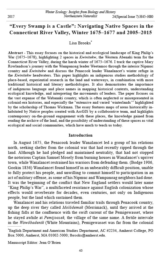


 The Northeastern Naturalist is a peer-reviewed journal that covers all aspects of natural history within northeastern North America. We welcome research articles, summary review papers, and observational notes.