A Checklist to the Common Cyprinid and Centrarchid
Fishes of the Bull and Upatoi Creeks Watershed of
Georgia with a Brief Glimpse of Correlative Urban
Influences and Land Use
Samantha L. Martin and William I. Lutterschmidt
Southeastern Naturalist, Volume 12, Issue 4 (2013): 769–780
Full-text pdf (Accessible only to subscribers.To subscribe click here.)
769
S.L. Martin and W.I. Lutterschmidt
22001133 SOUTSoHuEthAeSaTsEteRrnN NNaAtTurUaRliAstLIST 1V2o(4l.) :1726,9 N–7o8. 04
A Checklist to the Common Cyprinid and Centrarchid
Fishes of the Bull and Upatoi Creeks Watershed of
Georgia with a Brief Glimpse of Correlative Urban
Influences and Land Use
Samantha L. Martin1 and William I. Lutterschmidt1,2,*
Abstract - We sampled fishes from eight creeks within the Bull and Upatoi creeks watershed
in the summer months of June 2001 and August 2002 to provide a checklist of
common fishes. This sample and its data support a more comprehensive study by the
authors documenting an urbanization gradient among creeks and their associated differences
in fish assemblage structure within this aquatic system. However, here we provide
a simple, but useful, checklist of common Cyprinid and Centrarchid fishes to enhance
future species-monitoring efforts within this watershed. We collected a total 2407 individuals
representing 34 species from Lindsey, Cooper, Flatrock, Bull, Dozier, Randall,
Kendall, and Baker Creeks by seining. Lepomis macrochirus (Bluegill), Cyprinella
venusta (Blacktail Shiner), and Notropis buccatus (Silverjaw Minnow) were the most
abundant species within the Bull and Upatoi creeks watershed. Conversely, Pimephales
promelas (Fathead Minnow) and Pimephales vigilax (Bullhead Minnow) were the rarest.
We calculated and present species richness (S), total abundance (TA), Shannon-Weiner
diversity index (H'), maximum species diversity (H'max), and species evenness (J') for
all eight creeks within the watershed. Additionally, we discuss stream characteristics, related
microhabitat use by fishes within the watershed, and the potential influences of an
urbanization gradient on fish assemblage structure.
Introduction
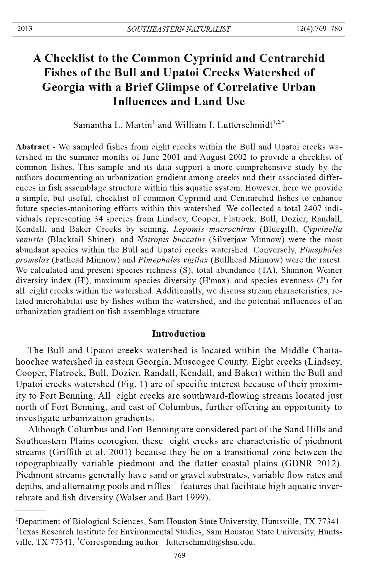
The Bull and Upatoi creeks watershed is located within the Middle Chattahoochee
watershed in eastern Georgia, Muscogee County. Eight creeks (Lindsey,
Cooper, Flatrock, Bull, Dozier, Randall, Kendall, and Baker) within the Bull and
Upatoi creeks watershed (Fig. 1) are of specific interest because of their proximity
to Fort Benning. All eight creeks are southward-flowing streams located just
north of Fort Benning, and east of Columbus, further offering an opportunity to
investigate urbanization gradients.
Although Columbus and Fort Benning are considered part of the Sand Hills and
Southeastern Plains ecoregion, these eight creeks are characteristic of piedmont
streams (Griffith et al. 2001) because they lie on a transitional zone between the
topographically variable piedmont and the flatter coastal plains (GDNR 2012).
Piedmont streams generally have sand or gravel substrates, variable flow rates and
depths, and alternating pools and riffles—features that facilitate high aquatic invertebrate
and fish diversity (Walser and Bart 1999).
1Department of Biological Sciences, Sam Houston State University, Huntsville, TX 77341.
2Texas Research Institute for Environmental Studies, Sam Houston State University, Huntsville,
TX 77341. *Corresponding author - lutterschmidt@shsu.edu.
S.L. Martin and W.I. Lutterschmidt
2013 Southeastern Naturalist Vol. 12, No. 4
770
Although Dahlberg and Scott (1971) have documented the freshwater fish diversity
in Georgia, there is limited information from current species inventories.
More recent research has indirectly added to the current fish records of western
Georgia (e.g., Helms and Feminella 2005, Schleigler 2000, Walsler and Bart 1999),
with a complete species atlas of Georgia’s freshwater fishes becoming available
through an online project proposed by Straight et al. (2009a). While Georgia is one
of the top five states for freshwater fish diversity, this URL (http://fishesofgeorgia.
uga.edu), hosted by the University of Georgia, provides the only current statewide
guide to the fishes of Georgia (Straight et al. 2009b). Moreover, there is currently
no diagnostic key available for Georgia fishes, and checklists for Georgia creeks
and watersheds are limited.
Our current study provides a checklist of the common Cyprinid and Centrarchid
fish species within the Bull and Upatoi creeks watershed to serve as a
baseline inventory. Such documentation may aid in future and more comprehensive
investigations of species composition for the monitoring of potential and
future changes in fish-community structure within the Middle Chattahoochee
watershed and the state of Georgia. This information might also prove useful in
comparisons with the high species diversity of other piedmont streams (Walser
and Bart 1999). Finally, we provide a preliminary look at the association between
species richness and an urban gradient among each of the eight creeks within the
Bull and Upatoi creeks watershed.
Methods
Site description
Lindsey, Cooper, Flatrock, Bull, Dozier, Randall, Kendall, and Baker Creeks
are arranged in an approximately parallel pattern progressing eastward from the
city of Columbus, GA (Fig. 1). Interestingly, each creek exhibits an array of unique
stream characteristics. All eight creeks have variable depth, flow, riparian zones,
and substrate types in accordance with general piedmont stream characteristics. We
primarily chose these eight creeks as sampling sites because they are located near
Fort Benning, a large military facility, the staff of which may find documentation
of species diversity useful for long-term monitoring. Moreover, the creeks demonstrate
an ideal west to east gradient of urbanization (i.e., urban land use) within
Muscogee County (Table 1, Fig. 2).
Collection, preservation, and analysis
We sampled eight creeks (Lindsey, Cooper, Flatrock, Bull, Dozier, Randall,
Kendall, and Baker) during the months of June 2001 and August 2002. We chose
three sites within each creek, using a segment of Macon Road east of Columbus,
GA within Muscogee County as a reference transect. We sampled three creek
pools north of, near, and south of Macon Road. Specifically, we selected a pool
as a collection site if it appeared to offer habitat for fishes, was wadeable, and the
bank was not channelized. Additionally, we chose pools as the preferred sampling
habitat because they have been shown to be the only meso-habitat for fishes within
771
S.L. Martin and W.I. Lutterschmidt
2013 Southeastern Naturalist Vol. 12, No. 4
Figure 1. Map of the Middle Chattahoochee watershed (USGS 2011) showing the sampled
streams (Lindsey, Cooper, Flatrock, Bull, Dozier, Randall, Kendall, Baker) within the
smaller Bull and Upatoi creeks watershed. These creeks are numbered from most westward
and urban to most eastward and rural and were accessed along Macon Road.
the streams of this area (DeVivo 1996). We did not sample fishes from the family
Percidae (i.e., darters) and their associated habitat (e.g., creek riffles and runs). The
scope of work outlined by the Civil Engineering and Research Laboratory (CERL)
of the US Army Corps of Engineers specifically requested that such sampling be
restricted from our survey to avoid the numerous darter species that are state and/or
federally listed as species of concern. Our sampling regimes were similar to those
reported by Dent and Lutterschmidt (2001), and each pool sample consisted of five
consecutive seine hauls across the entire width of the pool. Seines measured 4.6 m
by 1.2 m with 5-mm mesh.
We placed all collected fishes in a 10% formalin solution in separate plastic jars
according to the pool or segment in which they were collected. After all fishes were
S.L. Martin and W.I. Lutterschmidt
2013 Southeastern Naturalist Vol. 12, No. 4
772
fixed, they were identified to species and placed according to sample locality in
individual jars containing a 70% ethanol solution. All specimens have been deposited
into the Sam Houston State Vertebrate Museum (SHSVM) for long-term storage
and archival. This field research and specimen collection was conducted under
Figure 2. Map showing the respective land-use classifications within each creek’s (Lindsey,
Cooper, Flatrock, Bull, Dozier, Randall, Kendall, Baker) catchment areas within the Bull
and Upatoi creeks watershed.
Table 1. Classifications and percentages of urban land-use (Anderson et al. 1976) among the eight
creeks within the Bull and Upatoi creeks watershed summarized using GIS and the land-use classification
map (Fig. 2). Creeks include: Lindsey (Li), Cooper (Co), Flatrock (Fl), Bull (Bu), Dozier (Do),
Randall (Ra), Kendall (Ke), and Baker (Ba) which are ordered from most westward and urban to the
most eastward and rural.
Creek
Urban classification Li Co Fl Bu Do Ra Ke Ba
Low intensity residential 25.5 21.1 0.0 0.1 0.0 0.1 0.0 0.0
Commercial/industrial/transportation 10.0 11.1 5.5 1.1 1.7 0.3 0.0 0.1
Quarries/strip mines/gravel pits 1.4 0.0 0.0 0.6 0.0 0.0 0.0 0.0
Orchards and vineyards 0.0 0.0 0.0 0.0 0.0 0.0 0.0 0.0
Row crops 0.3 1.9 1.9 3.5 4.9 3.7 0.4 1.8
Pasture lands and hay production 2.1 2.2 13.2 5.3 6.4 4.3 0.3 0.5
Urban and recreational grass lands 3.6 2.1 0.0 3.2 0.5 0.2 0.0 0.0
Total percent urban land use 43.0 38.3 20.6 13.8 13.7 8.5 0.7 2.4
773
S.L. Martin and W.I. Lutterschmidt
2013 Southeastern Naturalist Vol. 12, No. 4
strict adherence to the methods and protocols outlined by the American Society of
Ichthyologists and Herpetologist (ASIH), American Fisheries Society (AFS), and
the American Institute of Fishery Research Biologists (AIFRB) for the collection
and preservation of animal specimens, and we made our collections under a scientific
collecting permit (29-WMB-01-147) issued by the GDNR.
We sorted and identified fish with the help of several keys (Mettee et al. 1996,
Pflieger 1997, Ross and Brenneman 2001) and then counted them for calculations
of species and population indices. We calculated species richness (S), total abundance
(TA), the Shannon-Weiner diversity index (H'), maximum species diversity
(H'max), and species evenness (J') for all eight creeks within the Bull and Upatoi
creeks watershed. We also used the percent similarity index (PSI) to evaluate similarities
in species composition and relative abundance between each of the eight
creeks (Krebs 1999).
Results and Discussion
We collected a total of 2407 fishes within the eight creeks of the Bull and Upatoi
creeks watershed representing 34 species (Table 2). Of these 34 fish species, the most
abundant species in our sample were Lepomis macrochirus (Bluegill), Cyprinella
venusta (Blacktail Shiner), and Notropis buccatus (Silverjaw Minnow), representing
47.1% of the total sample. These results are similar to those reported by Helms and
Feminella (2005), where Bluegill and Silverjaw Minnow were also the most abundant
within small streams of western Georgia. Conversely, Pimephales promelas
(Fathead Minnow) and Pimephales vigilax (Bullhead Minnow) were the least represented
within the sample and comprised only 0.1% of the sample.
Georgia has high species diversity, with a total of 47 families of fishes documented
by the University of Georgia and the Georgia Museum of Natural History.
Our sample represented 8 of the 47 (17%) families. Based upon an intensive but
short-term sampling regime, the 34 species we sampled most likely comprised the
more commonly occurring fishes in the Bull and Upatoi creeks watershed, but represented
only 10% of the documented species diversity in Georgia. The Cyprinid
family was the most well-represented family, with 13 species documented, and the
Centrarchid family was second with 10 species collected from the eight creeks.
Conversely, we collected only one species each from Fundulidae and Poeciliidae.
We collected one specimen of Aphredoderus sayanus (Pirate Perch), which is the
only species in the family Aphredoderidae, whereas Fundulidae and Poeciliidae
contain numerous species.
We sampled only a few darters in the family Percidae (i.e., Etheostoma and
Percina), and they are underrepresented as our sampling methodology did not
target this group for capture. According to the University of Georgia and the
Georgia Museum of Natural History website (Straight et al. 2009b), 53 species in
the family Percidae occur in Georgia (51 not including the genus Sander [pikeperch]).
Of those 51 species, nearly half (24) are considered rare and are listed
as threatened or endangered at the state or federal level. For the seven Percid
species that occur within the Chattahoochee River basin, Percina parvipinni
S.L. Martin and W.I. Lutterschmidt
2013 Southeastern Naturalist Vol. 12, No. 4
774
Table 2. Fish species and total abundance in the eight creeks within the Bull and Upatoi creeks watershed. Creeks include: Lindsey (Li), Cooper (Co),
Flatrock (Fl), Bull (Bu), Dozier (Do), Randall (Ra), Kendall (Ke), and Baker (Ba) which are ordered from most westward and urban to the most eastward
and rural. Nomenclature of fishes follows that of Page and Burr (1991) and Nelson (1994).
Creeks
Taxon/species Li Co Fl Bu Do Ra Ke Ba
Actinopterygii
Cypriniformes
Catastomidae
Erimyzon oblongus Mitchill (Eastern Creek Chubsucker) 0 0 0 2 0 1 0 0
Moxostoma poecilurum Jordan (Blacktail Redhorse) 0 0 0 0 0 4 12 0
Cyprinidae
Campostoma anomalum (Rafinesque) (Central Stoneroller) 0 3 0 9 32 12 81 117
Cyprinella venusta Girard (Blacktail Shiner) 0 3 0 9 0 72 280 7
Lythrurus atrapiculus (Snelson) (Blacktip Shiner) 0 0 0 0 11 0 10 12
Notemigonus crysoleucas (Mitchill) (Golden Shiner) 0 1 0 6 1 0 0 0
Notropis buccatus (Cope) (Silverjaw Minnow) 2 0 12 0 48 60 81 112
Notropis longirostris (Hay) (Longnose Shiner) 0 0 1 1 0 39 89 72
Notropis spp. (shiners) 0 0 0 1 0 0 1 6
Notropis texanus (Girard) (Weed Shiner) 2 19 14 15 5 24 58 15
Pimephales promelas Rafinesque (Fathead Minnow) 0 1 0 0 0 0 0 0
Pimephales vigilax (Baird and Girard) Bullhead Minnow 0 0 0 0 1 0 0 0
Semotilus atromaculatus (Mitchill) (Creek Chub) 0 0 0 0 1 0 15 15
Semotilus spp. (chubs) 0 0 0 0 0 3 1 5
Semotilus thoreauianus Jordan (Dixie Chub) 0 0 0 0 26 5 3 0
Cyprinodontiformes
Fundulidae
Fundulus olivaceous (Storer) (Blackspotted Topminnow) 0 0 0 0 0 5 0 0
Poeciliidae
Gambusia affinis (Baird and Girard) (Western Mosquitofish) 37 9 24 21 1 0 0 36
775
S.L. Martin and W.I. Lutterschmidt
2013 Southeastern Naturalist Vol. 12, No. 4
Table 2, continued.
Creeks
Taxon/species Li Co Fl Bu Do Ra Ke Ba
Perciformes
Centrarchidae
Lepomis auritus L. (Redbreast Sunfish) 12 2 47 13 17 20 18 47
Lepomis cyanellus Rafinesque (Green Sunfish) 0 1 0 0 1 0 0 0
Lepomis gulosus (Cuvier) (Warmouth) 0 1 2 2 0 0 0 1
Lepomis macrochirus Rafinesque (Bluegill) 14 2 190 22 28 42 12 137
Lepomis megalotis (Rafinesque) (Longear Sunfish) 0 1 0 0 0 1 0 0
Lepomis microlophus (Günther) Redear Sunfish) 0 1 20 1 0 1 0 0
Lepomis miniatus Jordan (Redspotted Sunfish) 3 0 0 0 0 0 0 0
Micropterus punctulatus (Rafinesque) (Spotted Bass) 19 0 5 0 0 0 10 0
Micropterus salmoides (Lacepëde) (Largemouth Bass) 4 1 1 9 2 15 0 6
Pomoxis nigromaculatus (Lesueur) Black Crappie 0 21 23 1 0 0 0 0
Pericidae
Etheostoma spp. (darters) 0 0 0 0 0 0 0 1
Percina nigrofasciata (Agassiz) (Blackbanded Darter) 0 0 0 2 0 0 9 5
Percina ssp. (darter) 0 2 0 0 0 1 0 0
Percopsiformes
Aphredoderidae
Aphredoderus sayanus (Gilliams) (Pirate Perch) 0 0 0 0 0 4 0 3
Siluriformes
Ictaluridae
Ameiurus melas (Rafinesque) (Black Bullhead) 0 0 0 4 0 0 2 0
Ameiurus natalis (Lesueur) (Yellow Bullhead) 2 0 0 0 1 1 7 10
Ameiurus nebulosus (Lesueur) (Brown Bullhead) 0 0 6 0 0 0 0 0
Total Abundance 95 68 345 118 175 310 689 607
S.L. Martin and W.I. Lutterschmidt
2013 Southeastern Naturalist Vol. 12, No. 4
776
(Goldstripe Darter) is state listed as rare and Percina crypta (Halloween Darter)
is considered state threatened. In our sample, we collected the fairly common
darter species Percina nigrofasciata (Blackbanded Darter).
All creeks sampled had a substrate composed of one or more of the following:
sand, gravel, and cobble. Additionally, Cooper, Randall, and Dozier creeks had
extensive riparian zones, while Flatrock, Kendall, and Bull creeks had more limited
riparian zones. Baker and Lindsey creeks were intermediate in terms of their
riparian zones, and depth and flow were variable within all creeks. All of these are
characteristics that typify Piedmont streams. Generally, H' tended to reflect pool
depth and to some extent riparian zones, especially in the case of Flatrock Creek
which had the lowest diversity (H' = 1.574) and also had shallow pools and a thin riparian
zone (Table 3). This finding may indicate that microhabitat space was limited.
Conversely, Bull Creek, which had the highest diversity (H' = 2.350), had deeper
pools but a sparse riparian zone; here, the presumably larger mesohabitat would
accommodate more niche space, yielding higher biodiversity. The lack of a dense
riparian zone suggests that bank vegetation and the accompanying energy inputs into
the creek may not impact biodiversity as heavily in this case. A similar trend emerged
when looking at diversity within Randall and Lindsey creeks. Randall Creek has the
second highest biodiversity (H' = 2.219) and had medium to deep pools and an extensive
riparian zone. Lindsey Creek had the second lowest diversity (H' = 1.719) and
had shallow pools and intermediate riparian vegetation (Table 3).
Evenness data also suggested that Bull Creek (J' = 0.847) offered more microhabitat
space, but Flatrock Creek (J' = 0.633) provided minimal microhabitats for
fish colonization (Table 3). Moreover, this survey tended to reflect that species
richness was approximately equal among all of the creeks, with richness highest
in Baker and Randall creeks (S = 18), and the lowest in Lindsey Creek (S = 9).
It is interesting that we collected only some species (e.g., Pimephales. promelas,
P. vigilax, Fundulus olivaceous) in only one of the eight creeks. However, we found
most fish species in more than one creek.
As discussed by Dent and Lutterschmidt (2001), the PSI (Krebs 1999) can be
used as a quantitative index where 0.0 indicates no similarity and 1.0 indicates
Table 3. Species richness (S), total abundance (TA), Shannon-Wiener diversity index (H'), maximum
species diversity (H'max), and species eveness (J') for the entire sample (i.e., all creeks) and the eight
creeks within the Bull and Upatoi creeks watershed.
Creek S TA H' H' max J'
All Creeks 34 2407 2.544 3.555 0.176
Lindsey 9 95 1.719 2.197 0.782
Cooper 15 68 2.008 2.708 0.741
Flatrock 12 345 1.574 2.485 0.633
Bull 16 118 2.350 2.773 0.847
Dozier 14 175 1.998 2.708 0.738
Randall 18 310 2.219 2.890 0.768
Kendall 17 689 1.947 2.833 0.687
Baker 18 607 2.181 2.890 0.755
777
S.L. Martin and W.I. Lutterschmidt
2013 Southeastern Naturalist Vol. 12, No. 4
complete similarity in species composition and relative abundance among sites
(Ludwig and Reynolds 1988, Wolda 1981). Percent similarity indices that are ≥0.7
and ≤0.4 are commonly used in fish community analyses (e.g., Cashner et al. 1994;
Lienesch et al. 2000; Dent and Lutterschmidt 2001; Matthews et al. 1988, 1996) to
indicate high or low similarity, respectively, among fish assemblages. Our percent
similarity data (Table 4) indicate moderate to low similarity among creeks, with
Dozier and Baker (PSI = 0.678) and Randall and Kendall (PSI = 0.656) having the
highest percent similarities. Although these percent similarities are below 0.7, it is
interesting that the highest percent similarities are for creeks that are comparable
with respect to their location (i.e., creeks 1 through 8; Fig. 1) and their relative
urbanization (Table 1, Fig. 2). Dozier and Baker are creeks 5 and 8 from the urban
center (Fig. 1) and have low urban land-use percentages of 13.7% and 2.4%, respectively
(Table 1). Similarly, Randall and Kendall are neighboring creeks (6 and
7; Fig. 1) and also have low urban land use 8.5% and 0.7%; Table 1). In comparison,
the most urban creek, Lindsey (location 1; 42% urban land use), and the most rural
creek, Baker (location 8; 2.4% urban land use), show almost no similarity (PSI =
0.110). We found a statistically significant negative relationship between PSI and
urban land-use among creeks, which indicates that similar levels of urbanization
(i.e., low urbanization difference) have higher percent similarity (Fig. 3). However,
because the level of urbanization is also associated with distance, this result may
be an artifact of auto-correlation between PSI and distance (Shurin et al. 2009).
The regression analysis with the use of PSI (Fig. 3) allows for a sample size of
n = 28 from the PSI triangular matrix (Table 4). Although sample size is reduced
(n = 8) with the use of community indices for each of the eight creeks, this analysis
removes the potential bias for the association of a high PSI among neighboring
creeks. Even with this reduced sample size, we found significant positive associations
between urban distance (Fig. 4a, 4b) and the community indices of species
richness (r = 0.791, P = 0.019) and total abundance (r = 0.879, P = 0.004). There
were also significant negative relationships between percent urban land-use (Fig.
4c, 4d) and the community indices of species richness (r = –0.797, P = 0.018)
and total abundance (r = –0.773, P = 0.024). These results show that urbanization
Table 4. A triangular matrix of percent similarity (Krebs 1999) showing the relative similarity among
the eight creeks within the Bull and Upatoi creeks watershed. Creeks include: Lindsey (Li), Cooper
(Co), Flatrock (Fl), Bull (Bu), Dozier (Do), Randall (Ra), Kendall (Ke), and Baker (Ba) which are
ordered from most westward and urban to the most easward and rural.
Creek Li Co Fl Bu Do Ra Ke Ba
Lindsey
Cooper 0.226
Flatrock 0.402 0.260
Bull 0.498 0.466 0.435
Dozier 0.309 0.160 0.330 0.385
Randall 0.287 0.242 0.285 0.454 0.492
Kendall 0.110 0.215 0.136 0.304 0.339 0.656
Baker 0.351 0.210 0.430 0.471 0.678 0.606 0.492
S.L. Martin and W.I. Lutterschmidt
2013 Southeastern Naturalist Vol. 12, No. 4
778
influences the community structure of fishes, and also demonstrates the importance
of watershed inventories.
It is likely that other fish species not listed here may occur within the Bull
and Upatoi creeks watershed, which is part of the larger Middle Chattahoochee
Figure 3. Regression analysis
showing the significant relationship
(PSI = 0.006 x urban difference
- 0.475) between the percent
similarity index (PSI) and the
urban difference between creeks
(F1,27 = 9.59; P = 0.005). Urban
difference alone explained 24.1%
(r2 = 0.241) of the variation in
the PSI. Dashed lines indicate
the upper and lower 95% confidence
intervals. Urban difference
was calculated by subtracting the
percent urban land use of each
creek. For example, the comparison
of Lindsey (43.0%) and Baker
(2.4%) creeks would result in an
urbanization difference of 40.6%.
F i g u r e 4 .
C o r r e l a -
tion analyses
showing the
s igni f i c ant
associations
between urban
distance
(a and b) and
percent urban
land use (c
and d) with
the community
indices of
species richness
(a and
c) and total
abundance (b
and d).
779
S.L. Martin and W.I. Lutterschmidt
2013 Southeastern Naturalist Vol. 12, No. 4
watershed. We collected 34 of the 338 total species found in Georgia (Straight et
al. 2009) at our sites within the Columbus area. This is one of the only ichthyofaunal
surveys that has specifically focused on documenting fish assemblages within
the Bull and Upatoi creeks watershed. Research personnel at nearby Fort Benning
should find our work useful as they plan and undertake environmental and species
monitoring. We sampled only during summer months, because summer and spring
samples generally facilitate a high presence of species (Dent and Lutterschmidt
2001). However, future fall and winter sampling may prove interesting. Also, studies
aimed at sampling and documenting fishes, including a specific sample aimed
at darter species composition within the entire Middle Chattahoochee watershed,
would be invaluable for understanding how fish-community structure in the larger
watershed might be used to predict fish occurrences within its smaller watersheds.
Ultimately, we hope that our data on fish species occurrences within the Bull and
Upatoi creeks watershed are useful for future monitoring and conservation efforts
within these unique urban creeks of Columbus, GA.
Acknowledgments
We thank Sidney M. Anderson, Laurieanne Dent, Riccardo A. Fiorillo, Daniel S. Millican,
and Dennis K. Wasco for their dedicated field and laboratory assistance as paid
technicians on this project. We also acknowledge a research grant awarded to William I.
Lutterschmidt by the Engineer Research and Development Center (ERDC) and the Civil
Engineering Research Laboratory (CERL) of the US Army Corps of Engineers (ERDCCERL
Contract #DACA 42-00-C-0047). We acknowledge the assistance provided by
Gordon A. Plishker and all personnel of the Texas Research Institute for Environmental
Studies (TRIES) at Sam Houston State University. We also thank Hugh Westbury of the
Strategic Environmental Research and Development Program (SERDP), Ecosystem Management
Project (SEMP), and Harold (Hal) Balbach of the US Army ERDC and CERL for
their sincere interest in and support of this project.
Literature Cited
Anderson, J.R., E.E. Hardy, J.T. Roach, and R.E. Witmer. 1976. A land-use and land-cover
classification system for use with remote sensor data. Geological Survey Professional
Paper 964. 41 pp. Available online at landcover.usgs.gov/pdf/Anderson.pdf.
Cashner, R.C., F.P. Gelwick, and W.J. Matthews. 1994. Spatial and temporal variation in the
distribution of fishes of the Labranche wetlands area of the Lake Pontchartrain estuary,
Louisiana. Gulf of Mexico Science 13:107–120.
Dahlberg, M.D., and D.C. Scott. 1971. The freshwater fishes of Georgia. Bulletin of the
Georgia Academy of Sciences, 29:1–64.
Dent, L., and W.I. Lutterschmidt. 2001. The ichthyofauna of Harmon and Wynne creeks
sampled within the center for biological fields studies, Walker County, Texas. Texas
Journal of Science 53(2):139–146.
DeVivo, J.C. 1996. Fishes as indicators of water quality in the Apalachicola-Chattahoochee-
Flint River basin. M.Sc. Thesis. The University of Georgia, Athens, GA. 196 pp.
Georgia Department of Natural Resources (GDNR). 2012. Piedmont, ecoregional overview.
Available online at http://www1.gadnr.org/cwcs/PDF/11_Piedmont.pdf. Accesssed
24 July 2012.
S.L. Martin and W.I. Lutterschmidt
2013 Southeastern Naturalist Vol. 12, No. 4
780
Griffith, G.E., J.M. Omernik, J.A. Comstock, S. Lawrence, G. Martin, A. Goddard, V.J.
Hulcher, and T. Foster. 2001. Ecoregions of Alabama and Georgia. (2-sided color poster
with map [scale 1:1,700,000], descriptive text, summary tables, and photographs). US
Geological Survey, Reston, VA.
Helms, B.S., and J.W. Feminella. 2005. Detection of biotic responses to urbanization using
fish assemblages from small streams of western Georgia, USA. Urban Ecosystems,
8:39–57.
Krebs, C.J. 1999. Ecological Methodology, 2nd Edition. Addison Wesley Longman, Inc.,
New York, NY. 620 pp.
Lienesch, P.W., W.I. Lutterschmidt, and J.F. Schaefer. 2000. Seasonal and long-term
changes in the fish assemblage of a small stream isolated by a reservoir. Southwestern
Naturalist 45:274–288.
Ludwig, J.A., and J.F. Reynolds. 1988. Statistical Ecology. John Wiley and Sons, Inc., New
York, NY 337 pp.
Matthews, W.J., R.C. Cashner, and F.P. Gelwick. 1988. Stability and persistence of fish
faunas and assemblages in three midwestern streams. Copeia, 1988:945–955.
Matthews, W.J., M.S. Schorr, and M.R. Meador. 1996. Effects of experimentally enhanced
flows on fishes of a small Texas (USA) stream: Assessing the impact of interbasin transfer.
Freshwater Biology, 35:349–362.
Mettee, Jr., M.F., P.E. O’Neil, and J.M. Pierson. 1996. Fishes of Alabama and the Mobile
Basin. Oxmoor House, Birmingham, AL. 820 pp.
Nelson, J.S. 1994. Fishes of the World, 3rd Edition. John Wiley and Sons, Inc., New York,
N Y. 600 pp.
Page L.M., and B.M. Burr. 1991. Freshwater Fishes. Houghton Mifflin Co., New York, NY.
432 pp.
Pflieger, W.L. 1997. The Fishes of Missouri. Conservation Commission of the State of Missouri,
Jefferson City, MO. 372 pp.
Ross, S.T., and W.M. Brenneman. 2001. The Inland Fishes of Mississippi. University Press
of Mississippi, Jackson, MS. 624 pp.
Schleigler, S.L. 2000. Use of an index of biological integrity to detect effects of land uses on
stream fish communities in west-central Georgia. Transactions of the American Fisheries
Society 129 1118–1133.
Shurin, J.B., K. Cottenie, and H. Hillebrand. 2009. Spatial autocorrelation and dispersal
limitation in freshwater organisms. Oecologia 159:151–159.
Straight C.A., B.A. Freeman, B. Albanese, and M.C. Freeman. 2009a. Fishes of Georgia:
A freshwater fish atlas. Proceedings of the 2009 Georgia Water Resources Conference;
27–29 April 2009; University of Georgia, Athens, GA.
Straight, C.A., B. Albanese, and B.J. Freeman. 2009b. Fishes of Georgia website, Georgia
Museum of Natural History, Athens, GA. Available online at http://fishesofgeorgia.uga.
edu. Accessed 24 July 2012.
United States Geological Survey (USGS). 2011. Science in your watershed map. Available
online at http://water.usgs.gov/wsc/cat/03130003.html. Accessed 2 December 2013.
Walsler, C.A., and H.L. Bart, Jr. 1999. Influence of agriculture on in-stream habitat and fish
community structure in Piedmont watersheds of the Chattahoochee River System. Ecology
of Freshwater Fish 8:237–246.
Wolda, H. 1981. Similarity indices, sample size,and diversity. Oecologia 50:296–302.


 The Southeastern Naturalist is a peer-reviewed journal that covers all aspects of natural history within the southeastern United States. We welcome research articles, summary review papers, and observational notes.