2006 SOUTHEASTERN NATURALIST 5(1):93–102
Comparison of Sandhills and Mixed Pine-hardwood
Communities at Fort Benning, Georgia
BEVERLY COLLINS1,*, REBECCA SHARITZ1, KATHRYN MADDEN1,
AND JOHN DILUSTRO1
Abstract - Fall Line sandhills vegetation occurs on dry, sandy ridgetops and supports
a suite of rare or uncommon plant species (TES). We surveyed nine sandhills sites
and 32 “matrix” mixed pine-hardwood stands at Fort Benning to characterize canopy
and groundlayer vegetation patterns and determine the extent of sandhills vegetation,
including characteristic dominant species and TES, over the upland landscape. The
relative abundance of Pinus palustris (longleaf pine), P. taeda (loblolly pine), and P.
echinata (shortleaf pine) and sandhills oaks contributed to canopy composition
differences among sites. The sandhills communities support a unique set of
groundlayer species, including state-listed Chrysoma pauciflosculosa. Although
there is some species overlap, especially in overstory composition, characteristic
sandhills vegetation is not widely distributed in mixed pine-hardwood stands at Fort
Benning and conservation might best be achieved by maintaining existing sites.
Introduction
Fire-adapted longleaf pine-scrub oak communities of the Coastal Plain–
Piedmont Fall Line Sandhills region from Georgia to North Carolina (Keys
1995) support a characteristic flora that includes a suite of rare or uncommon
plant species (Table 1). These communities occur on dry, sandy ridgetops
(Christensen 1988, Jacqmain et al. 1999), which are remnants of ancient
dunes in the Fall Line region. More fertile, less droughty sites and slopes in
this region grade into upland pine and hardwood forests (Skeen et al. 1993,
Ware et al. 1993).
Land use, including agriculture and fire exclusion since European settlement,
likely has modified sandhills vegetation (Christensen 1988), including
the distributions of rare and uncommon species. Currently, many upland
forests on federal and state lands in the Fall Line region are managed
through periodic harvests and prescribed fires to promote habitat for the
endangered Picoides borealis Viellot (Red-cockaded Woodpecker). Understanding
how characteristic sandhills communities are arrayed over
landscape and land management gradients can contribute to an ecological
understanding of these communities and inform land-management
decisions. We surveyed and compared sandhills communities that contain
threatened sandhills species (Table 1) and a representative set of upland
forests that range within the gradient from sandhills scrub oak-pine to pinehardwood
stands (Dilustro et al. 2002) to characterize canopy and
groundlayer vegetation patterns and determine the extent of sandhills vegetation
over the upland landscape at Fort Benning.
1Savannah River Ecology Laboratory, PO Drawer E, Aiken, SC 29802. *Corresponding
author - Collins@srel.edu.
94 Southeastern Naturalist Vol. 5, No. 1
Methods
Fort Benning is located in the Sandhills region (Keys et al. 1995) on the
Coastal Plain-Piedmont Fall Line in west-central Georgia and eastern Alabama.
The installation, which now covers 73,533 ha, was acquired in phases
from 1918 through 1942. Prior land-use was mainly farming and grazing,
with some remnant forested land. The climate is temperate, with maximum
summer temperatures averaging 32 °C (Johnson 1983). Precipitation averages
132 cm per year; 50% falls from April to September (Johnson 1983).
The terrain of the base is characteristic Fall Line topography, with level
ridge tops and gentle slopes. Upland soils on our study sites are primarily
ultisols and entisols and include Troup sandy loams, Lakeland sands, Siley
loamy sand, and Nankin sandy loams (Johnson 1983).
We selected state (GA) or federally listed threatened or endangered plant
species (TES) that typically occupy sandhills habitats (Table 1) and may extend
into sandy woodlands and dry upland woodlands (Radford et al. 1968). We
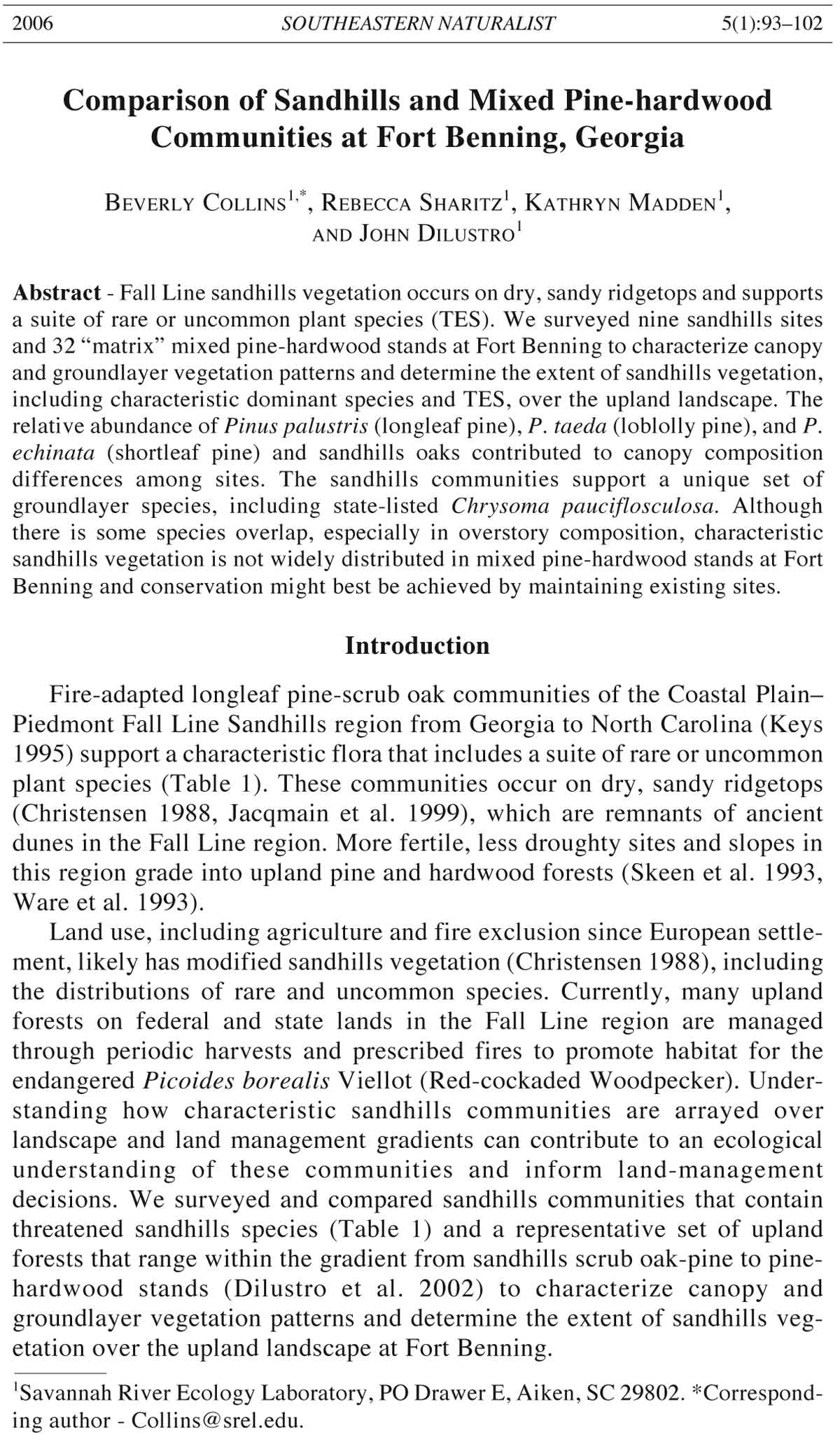
selected nine sites at Fort Benning with one or more of the TE species (Fig. 1),
using GIS-data provided by the The Nature Conservancy. In 2003, these sites
were surveyed for vegetation (summer months) and soil texture (winter
months). TES plant populations were delineated and transects, spaced 30 m
apart (100 m apart for extremely large populations), were established.
Transects reach just outside the population boundary. At 30-m intervals along
each transect, a 1- x 1-m plot was established to estimate percent cover of herbs,
bare ground, and woody debris to the nearest one percent. Canopy species were
quantified at each point using point-quarter method.
Canopy and groundlayer vegetation on the TES sites were compared to a
set of 32 upland forest stands (Fig. 1), each 400 m square, that are part of a
larger study of the ecological effects of land-use and management practices
on upland forests at Fort Benning. These stands represent the range of
“matrix” upland forest canopy composition at Fort Benning. They include
Table 1. Some plant species of concern in the Fall Line Sandhills region of Georgia. * denote
threatened or endangered species found at the Fort Benning sites.
Conservation
Scientific name Common name statusA
Astragalus michauxii (Kuntze) F.J. Herm. Sandhill milk-vetch G3; GA-S2
Baptisia lanceolata (Walt.) Ell. Lance-leaf wild indigo G4; GA-S4
Carphephorus bellidifolius (Michx.) Torr. & Gray Sandhill chaffhead G4; GA-S1
Chrysoma pauciflosculosa (Michx.) Greene * Woody goldenrod G4,G5; GA-S3
Liatris secunda Ell. Sandhill gay-feather G4,G5; GA-S1
Nolina georgiana Michx. Georgia beargrass G3, G5; GA-SNR
Phaseolus polystachios (L.) B.S.P. * Sandhills bean G4,T3; GA-S2
Stylisma pickeringii (Torr. Ex M.A. Curtis) Gray * Pickering’s morning-glory G4,T3; GA-S2
Warea cuneifolia (Muhl. ex Nutt.) Nutt. * Sandhill-cress G4; GA-S3
AState (GA-S) or Global (G, T) rankings: SNR = species not ranked; S2, G2 = Imperiled; S3, G3
= Very rare and local throughout its range or found locally in a restricted range; S4, G4 =
Apparently secure, although it may be quite rare in parts of its range; G5 = Secure globally; T
= Threatened. Table source: Georgia Department of Natural Resources 2004.
2006 B. Collins, R. Sharitz, K. Madden, and J. Dilustro 95
mixed pine-hardwoods (6 stands) and pine stands dominated by longleaf (7
stands), loblolly (15 stands), or shortleaf pine (4 stands). Half of the sites are
in land compartments open to mechanized training (tracked vehicles,
heavier military use). The remaining sites are in compartments limited to
dismounted infantry training (foot traffic, lighter military use). All sites are
in active forest management and were prescribe-burned in early 2000. Half
were burned again in early 2002 (2-yr stands) as part of the experimental
land-use treatments for the larger study.
In each 400- x 400-m stand, we established a 100- x 100-m vegetation
sampling plot gridded at 20-m intervals to yield 25 sampling points in each
stand. In 2003, trees were surveyed at each of the 25 points using the point
quarter method. Groundlayer vegetation, defined as vegetation < 1.4 m tall,
was surveyed by line-intercept along a 6-m transect at each sampling point.
Vegetation that intercepted the vertical plane of the transect was included.
Proportional representation of each species in the canopy of a site or group
of sites (see below) was calculated from diameter at breast height (dbh)
Figure 1. Location of TES (triangles) and mixed pine-hardwood sites (circles) at Ft.
Benning. Sites are exaggerated relative to map scale and overlapping sites are hidden.
Dark triangles indicate two unique TES sites; outlined circles indicate five mixed pinehardwood
sites closest in canopy composition to the TES sites (see results).
96 Southeastern Naturalist Vol. 5, No. 1
values. Groundlayer data for the TES and mixed pine-hardwood forest sites
were combined by converting to percents and standardizing values for each
species within each plot to 100%. Nonmetric multidimensional scaling
(NMDS; SAS v. 9), based on Lance-Williams (Bray-Curtis) dissimilarities,
was used to explore patterns in canopy and groundlayer vegetation among the
stands. Canopy-tree ordination results were used to distinguish overstory
groups. Analysis of dissimilarity (ANOSIM; SAS v. 9), based on Lance-
Williams dissimilarities, was used to test differences in canopy and
groundlayer vegetation composition among overstory groups (Clarke’s R:
dissimilarity between groups > dissimilarity within groups; Clarke 1993).
Stepwise analysis of dissimilarity (ANOSTEP; P. Minchin, Southern Illinois
University, Edwardsville, IL, unpubl. data), based on Bray-Curtis dissimilarities,
was used to identify the suite of tree species that contributed most to
compositional differences among overstory groups. Indicator species analysis
or ISA (Dufrêne and Legendre 1997) was used to identify the groundlayer
species that best discriminated groups. Significance of the test statistic, IVmax ,
was tested by random permutation with 1000 trials (PC-ORD v. 4).
Results
Canopy composition
NMDS revealed that canopy composition of two of the nine sites where
sandhills TES are known to occur is distinct from that of the other seven sites
(Figs. 1 and 2; TES sites noted by triangles, distinct sites by darker triangles).
These seven sites appear to have similar composition to five of the 32 mixedpine
stands (noted by outlined circles in Figs. 1 and 2). The remaining mixed
pine stands form a large third “group” of sites (Fig. 2). The five mixed pinehardwood
sites that are most similar in composition to the TES sites are not the
closest to them on the landscape (Fig. 1); further, there was no relationship
between physical distance and compositional similarity of the TES and mixed
pine sites (regression results not reported).
Weighted by abundances, community similarity was low (dissimilarity
averaged 77%) between the two unique TES sites and the group that included
the five other TES sites; similarity was somewhat higher (dissimilarity averaged
67%) between the latter five sites and the mixed pine-hardwood group.
Stepwise analysis of dissimilarity (ANOSTEP, P. Minchin, unpubl. data)
revealed abundances of Pinus palustris, P. taeda, and Quercus laevis contributed
to differences among the three groups. Pinus palustris dominated the
group of seven TES sites and five mixed pine-hardwood stands (Table 2). The
two TES sites that were separated in the ordination were similar to the other
seven TES sites in having Quercus laevis as an important canopy species, but
they had low representation of Pinus palustris and higher representation of
Quercus hemisphaerica and Q. margaretta. Pinus taeda was the more important
pine in these two sites, and it was the dominant canopy species in the large
group of mixed pine-hardwood stands (Table 2).
Trees were significantly smaller (P = 0.0003) in the TES sites (mean dbh
= 18.7 cm for the two unique sites and 23.7 cm for the remaining five sites)
2006 B. Collins, R. Sharitz, K. Madden, and J. Dilustro 97
Figure 2. NMDS of canopy composition among nine stands with sandhills TES
(triangles) and 32 mixed pine stands (solid circles) at Fort Benning. Dark triangles = two
“unique” TES sites; outlined circles = five mixed pine sites most similar to TES sites.
Table 2. Canopy composition (species percentages) of the two TES sites with unique composition
(2 TES), the other seven TES sites, the five mixed pine-hardwood sites that were grouped
with the TES sites (5 Mixed), and all other mixed pine-hardwood sites (27 Mixed). Bold text
indicate TE species that comprise ≥ 10% of the canopy vegetation; - indicate TE species not
present within the grouped stands; only species that comprise ≥ 1% of the canopy in at least one
group of stands are shown.
2 TES 7 TES 5 Mixed 27 Mixed
Carya spp. - 1.1 0.2 3.6
Cornus florida L. - 0.4 0.7 1.2
Cratagus spp. - 0.1 - 0.1
Diospyrus virginiana L. - 0.1 - 0.1
Liquidambar styraciflua L. 2.4 0.3 0.6 5.7
Liriodendron tulipifera L. - - - 1.4
Pinus echinata P. Mill. 9.7 0.6 3.9 14.7
P. palustris P. Mill. 6.8 64.0 75.7 5.9
P. taeda L. 15.3 1.6 13.3 47.6
Quercus alba L. - - - 1.5
Q. hemisphaerica Willd. 17.3 0.2 - -
Q. falcata Michx. - 1.2 1.5 6.6
Q. incana Bartr. - 0.6 - 0.4
Q. laevis Walt. 33.7 24.1 0.1 0.7
Q. margaretta Ashe 11.3 2.9 1.4 2.0
Q. marilandica Muenchh. 1.8 0.4 0.3 0.4
Q. nigra L. - - 0.3 5.2
Q. stellata Wagenh. - - 1.2 0.1
98 Southeastern Naturalist Vol. 5, No. 1
than in the five most similar (mean = 35.3 cm), or the remaining (mean =
37.2 cm), mixed pine-hardwood stands. Soils in the two unique TES sites
averaged 4% clay and 94% sand content; the remaining TES sites averaged
8% clay and 89% sand. The five mixed pine-hardwood sites that were most
similar to the TES sites included both sandy (75–90% sand) and clayey (11–
32% clay) soil categories, and both lighter and heavier military-use categories;
however, all were in the group of sites that were prescribe-burned in
both 2000 and 2002. In addition, these five sites are in land-management
compartments that had burned (prescribed fire or wildfire) an average of 4.5
times over the preceding 20 years (1980–2000; data from the Fort Benning
historical fire coverage). The remaining mixed pine-hardwood sites are in
compartments that had burned an average of 3.8 times; the TES sites, with
the exception of the two that grouped by themselves, had burned 4 times
over the last 20 years. The two unique TES sites are in compartments that
had only burned once between 1980 and 2000.
Groundlayer composition
NMDS revealed that groundlayer composition differed between the TES
sites and the mixed pine-hardwood stands (Fig. 3). Vitis sp., Andropogon sp.
(primarily A. virginicus L.), Myrica cerifera, and Vaccinium arboreum were
the most abundant plants in the groundlayer of mixed pine-hardwood sites,
while Rhus copallinun and Vaccinium species (V. stamineum, V. myrsinites,
V. arboreum) were most abundant in the TES sites (Table 3). MDS scores
among the TES sites primarily reflected differences in abundance of the
Vaccinium species and increasing abundance, from lower right to upper left
Figure 3. NMDS of groundlayer species (herbs and woody seedlings and sprouts) in
nine sites (two sites overlap) with sandhills TES (triangles) and 32 mixed pine
forests (circles).
2006 B. Collins, R. Sharitz, K. Madden, and J. Dilustro 99
in Fig. 3, of one of the TE species, Chrysoma pauciflosculosa (woody
goldenrod). Indicator species analysis revealed a suite of taxa that discriminated
between the TES and mixed pine-hardwood sites (Table 3). These
included dominant taxa (Myrica cerifera, Pteridium aquilinum, Vitis sp.)
and minor species (< 1% of vegetation) that had little overlap between the
TES and mixed pine-hardwood sites (Table 3).
We asked if the five mixed pine-hardwood stands that were similar to the
TES sites in canopy composition (Fig. 2) were also more similar to them in
groundlayer composition than were the other mixed pine stands. Average
dissimilarity did not differ (P > 0.05); mean dissimilarity was 0.57 between
the five sites and the TES sites compared to 0.58 between the remaining
mixed pine-hardwood stands and the TES sites. The five mixed pine-hardwood
sites also had more dominant species in common with the other mixed
pine-hardwood sites than with the TES sites (Table 3). Only Pteridium
aquilinum was more abundant in the five mixed pine-hardwood and TES
sites than in the other mixed pine-hardwood sites (Table 3).
Table 3. Groundlayer composition (species percentages) of the nine TES sites, the five mixed
pine-hardwood sites that were grouped with the TES sites (5 Mixed), and all other mixed pinehardwood
sites (27 Mixed) and indicator values (IV) of the taxa for the two ordination groups
(TES sites and mixed pine-hardwood sites, Fig. 3). Bold text indicate TE species that comprise
≥ 4% of the vegetation or have significant IV (P < 0.01); - indicates TE species not present
within a group of stands; only species that comprise ≥ 2% of the vegetation in at least one group
of stands or have highly significant IV (P ≤0.001) are shown.
Abundance (%)
TES 5 Mixed 27 Other IV P
> 2% of vegetation
Andropogon sp. 1.4 10.7 5.9 65.4 0.4660
Callicarpa americana L. 3.6 2.0 1.3 10.6 1.0000
Collinsonia serotina Walt. 1.0 2.4 0.3 9.4 0.7165
Chrysoma pauciflosculosa (Michx.) Greene 3.4 - - 44.4 0.0012
Elephantopus tomentosus L. 1.1 2.3 1.9 75.0 0.0003
Gelsemium sempervirens St. Hil. 1.8 0.8 2.5 66.3 0.2631
Myrica cerifera Small - 4.8 5.0 78.1 0.0007
Pityopsis graminifolia Nutt. 1.5 1.8 3.2 55.1 0.6606
Pteridium aquilinum Kuhn 3.6 5.6 2.3 77.4 0.0011
Rhus copallinum L. 4.6 3.9 3.7 88.5 0.1146
Rubus sp. 2.9 2.3 3.4 99.5 0.0001
Sorghastrum secundum Nash 3.1 - 0.2 100 0.0001
Tephrosia virginiana Pers. 1.3 3.3 0.5 44.3 0.0598
Toxicodendron radicans Kuntze 3.3 1.8 2.2 88.6 0.0003
Vaccinium arboreum Marsh. 4.1 5.6 5.2 88.3 0.0763
Vaccinium elliottii Chapman 2.2 2.2 2.9 65.6 0.0051
Vaccinium myrsinites Lam. 4.3 1.1 0.7 33.3 0.3667
Vaccinium stamineum L. 5.1 2.9 3.8 88.6 0.0509
Vitis sp. 2.0 4.4 9.9 90.6 0.0001
< 2% vegetation
Amphicarpa bracteata Fern. - 1.2 1.0 75 0.0005
Aristida sp. 0.9 0.6 - 66.6 0.0001
Gaylussacia dumosa Torr.& Gray 1.0 - - 77.8 0.0001
Minuartia caroliniana Mattf. 0.9 - - 66.7 0.0001
100 Southeastern Naturalist Vol. 5, No. 1
We also examined patterns in the distribution of tree regeneration (seedlings
and sprouts < 1.4-m height) in the groundlayer. NMDS revealed the same
pattern as shown by the total groundlayer (herbs and tree seedlings/sprouts
combined, Fig. 3). Sandhills scrub oaks, Quercus laevis (two sites), Q.
hemispherica (two sites) and Q. margaretta (one site), were the most abundant
seedlings/sprouts in the TES sites. In the mixed pine-hardwood stands, Liquidambar
styraciflua was the most abundant species in 17 sites, Quercus
stellata in three sites, and Ilex glabra (L.) Gray and Pinus taeda in two sites.
Discussion
The relative abundance and species present of pines (Pinus taeda, P.
palustris, P. echinata) and oaks (Quercus laevis, Q. hemisphaerica, Q.
margaretta) associated with dry or sandhill communities (Christensen 1988,
Jacqmain et al. 1999) contributed to canopy composition differences among
sites with sandhills TE species and 32 “matrix” mixed pine-hardwood stands
at Fort Benning. Pinus palustris (longleaf pine) and Quercus laevis (turkey
oak), were dominants in seven of the nine sites with sandhills TES, while P.
taeda (loblolly pine), Q. laevis, Q, hemisphaerica, and Q. margaretta were
abundant in the remaining two TES sites. Longleaf shared dominance with
loblolly pine in five mixed pine-hardwood stands, while loblolly and P.
echinata (shortleaf pine) were most abundant in the remaining 27 stands.
Thus, the five mixed pine-hardwood sites are similar to seven of the TES
sandhills sites with respect to the pine component of the canopy, but they
lack the dominant oaks that re-sprout after fire and characterize dry, firemaintained
sandhills scrub communities (Jacqmain et al. 1999). The two
distinct TES sites lack a strong longleaf component, but all TES sites are
characterized by sandhills oaks.
The sandhills sites also are distinct from the mixed pine-hardwood sites
in structure; trees are smaller (smaller average dbh). The two distinct TES
sites had the smallest trees (dbh averaged 18.7 cm compared to 23.7 for the
remaining TES sites). These sites also had sandier soil (average 94% compared
to 89%), but less open canopy (60% compared to 38%), and had
burned less frequently over the past 20 years (once compared to 4 times)
than the other TES sites. Thus, the two distinct TES sites are among the
sandiest, least productive, and least frequently burned (over the last 20
years) sites we surveyed on Fort Benning.
Composition of the forest groundlayer (herbs and woody species < 1 m)
and regeneration (woody seedlings and sprouts < 1 m) overlapped little
between the entire group of 32 mixed pine-hardwood sites and the TES sites.
Vaccinium was abundant in all sites, but species presence and abundance
varied between the mixed pine-hardwood and TES sites, and among the TES
sites. In addition to Vaccinium spp., one of the TE species, Chrysoma
pauciflosculosa, was a dominant in the TES sites, while Andropogon sp.
(primarily A. virginicus) and Vitis sp., both of which are found in sandhill
communities, pine plantations, and upland hardwood forests (Workman and
McLeod 1990), were most abundant in the mixed pine-hardwood stands. The
2006 B. Collins, R. Sharitz, K. Madden, and J. Dilustro 101
most common dominant seedling/sprouting species in the mixed pine-hardwood
sites, Liquidambar styraciflua (most abundant species in 17 sites), is
associated with old fields, pine plantations, and upland hardwood forests,
but may be less common in sandhills communities (Workman and McLeod
1990) and was not abundant in the TES sites. Sandhills oaks, Quercus laevis,
Q. hemispherica, and Q. margaretta, were dominants of seedling/sprout
regeneration in the TES sites. These results suggest the groundlayer and
regenerating canopy trees show more “site fidelity” than do the canopy trees
and provide further evidence that the TES sites are on a different successional
trajectory from the mixed pine-hardwood sites.
Some of the differences in groundlayer composition between the TES and
mixed pine-hardwood sites, including the greater abundance of sandhills oaks
in the regeneration pool of the TES sites, may due to soil texture. Dilustro et al.
(2002, 2005) have shown linkages among soil texture, soil moisture cycles, and
groundlayer composition at Fort Benning. Soil moisture and physical properties,
including texture, have been shown to be related to the distribution of sand
ridge vegetation and sandhills oaks (Q. laevis, Q. margaretta) relative to
intermediate and wet coastal plain sites (Jacqmain et al. 1999).
Composition of the groundlayers of sandhills and mixed pine-hardwood
forest at Fort Benning also may be related to historical land use, including
the fire regime, or the interaction of land use and soil characteristics.
Species, such as Pityopsis graminifolia, that show increased presence or
biomass after fire (Anderson and Menges 1997) were common throughout
the mixed pine-hardwood and TES sites. In addition, some forbs, such as
species of Eupatorium (primarily E. capillifolium (Lam.) Small and E.
compositifolium Walt.), Tephrosia virginiana, and T. spicata (Walt.) Torr.
& Gray, have a positive relationship with the frequency of recent fires
(1980–2000) in the mixed pine-hardwood sites (B. Collins, unpubl. data),
and were common in the sandhills TES sites.
Overall, our results indicate communities with the TE species differ from
the “matrix” mixed pine-hardwood stands surveyed in the relative abundance
of particular species in the groundlayer and the abundance of sandhills
oaks in the canopy and regeneration pool. The mixed pine-hardwood stands,
including those with abundant longleaf pine, do not appear to be regenerating
toward typical sandhills vegetation while the TES sites, including those
with abundant loblolly pine, have distinct “sandhills” groundlayer composition
that includes Vaccinium species and abundant sprouts and seedlings of
sandhills oaks. These results suggest that conservation of sandhills
groundlayer communities, including TES and regenerating canopy dominants,
may best be achieved by maintaining existing sites at Fort Benning.
Acknowledgments
This research was supported by Department of Defense Strategic Environmental
Research and Development Program (SERDP) SI-1302, SERDP Ecosystem Management
Project CD-1114E-00, and Financial Assistance Award Number DE-FC09-
96SR18546 between the US Department of Energy and the University of Georgia. For
their help with this research, we thank: Don Imm, Lisa Duncan, James Mason, Marlon
102 Southeastern Naturalist Vol. 5, No. 1
Smith, Erin Kough, Thomas Lee, Mary Harper, Jason Baxley, Aaron Campbell, Linda
Lee, Leslie Zorn, Aubree McArthur, Aaron Knowles, and the natural resources staff at
Fort Benning. Hal Balbach provided thoughtful comments on the manuscript.
Literature Cited
Anderson, R.C., and E.S. Menges. 1997. Effects of fire on sandhill herbs: Nutrients,
mycorrhizae, and biomass allocation. American Journal of Botany 84:938–948.
Christensen, N.L. 1988. Vegetation of the southeastern coastal plain. Pp. 317–364,
In M.G. Barbour and W.D. Billings (Eds.). North American Terrestrial Vegetation.
Cambridge University Press, Cambridge, UK. 434 pp.
Clarke, K.R. 1993. Nonparametric multivariate analyses of changes in community
structure. Australian Journal of Ecology 18:117–143.
Dilustro J.J., B. Collins, L. Duncan, and R. Sharitz. 2002. Soil texture, land use
intensity, and vegetation of Ft. Benning upland forest sites. Journal of the Torrey
Botanical Society 129(4):80–297.
Dilustro, J.J., B. Collins, L. Duncan, and C. Crawford. 2005. Moisture and soil
texture effects on soil CO2 efflux components in southeastern mixed pine forests.
Forest Ecology and Management 204:87–97.
Dufrêne, M., and P. Legendre. 1997. Species assemblages and indicator species: The
need for a flexible asymmetrical approach. Ecological Monographs 67:345–366.
Georgia Department of Natural Resources. 2004. Natural Heritage Program. Special
concern plant species in Georgia. Available at: http://
georgiawildlife.dnr.state.ga.us.
Jacqmain, E.I., R.H. Jones, and R.J. Mitchell. 1999. Influences of frequent coolseason
burning across a soil moisture gradient on oak community structure in
longleaf pine ecosystems. American Midland Naturalist 141:85–100.
Johnson, J.H. 1983. Soil survey of Muscogee County, Georgia. US Department of
Agriculture, Soil Conservation Service, Columbus, GA. 130 pp.
Keys, Jr., J.A., C.A. Carpenter, S.L. Hooks, F.G. Koeneg, W.H. McNab, W.E.
Russell, and M.L. Smith. 1995. Ecological units of the eastern United States—
first approximation. Technical Publication R8-TP 21. Map (scale 1:3,500,000).
US Department of Agriculture, Forest Service, Atlanta, GA.
Radford, A.E., H.E. Ahles, and C.R. Bell. 1968. Manual of the vascular flora of the
Carolinas. The University of North Carolina Press, Chapel Hill, NC. 1183 pp.
Skeen, J.N., P.D. Doerr, and D.H. van Lear. 1993. Oak-hickory-pine forests. Pp. 1–
34, In W.H. Martin, S.G. Boyce, and A.C. Echternacht (Eds.). Biodiversity of the
Southeastern United States Upland Terrestrial Communities. John Wiley and
Sons, Inc., New York, NY. 502 pp.
Ware, S., C. Frost, and P. Doerr. 1993. Southern mixed hardwood forest: The former
longleaf pine forest. Pp 447–493, In W.H. Martin, S.C. Boyce and A.C.
Ecternacht (Eds.). Biodiversity in the Southeastern United States: Lowland Terrestrial
Communities. John Wiley and Sons, New York, NY. 502 pp.
Workman, S.W., and K.M. McLeod. 1990. Vegetation of the Savannah River Site:
Major community types. Savannah River Site National Environmental Research
Park Program SRO-NERP-19. 137 pp.


 The Southeastern Naturalist is a peer-reviewed journal that covers all aspects of natural history within the southeastern United States. We welcome research articles, summary review papers, and observational notes.