2007 SOUTHEASTERN NATURALIST 6(4):633–656
Monitoring-based Assessment of Gap-analysis Models
Jill A. LaBram1, Amanda E. Peck1, and Craig R. Allen2,*
Abstract - Gap-analysis models of vertebrate species richness are primarily created
based on literature and expert review to predict individual species’ occurrences and
overall richness of vertebrates. Such models need validation based on empirical data
to assess their accuracy. We describe and apply a new technique for assessing the
accuracy of spatially explicit models. We evaluated the accuracy of South Carolina
gap-analysis vertebrate models of predicted occurrence for reptile, amphibian, and
mammal species on the Savannah River Site, SC, by comparing the agreement between
gap-analysis models with models derived from multi-year monitoring data.
We determined the species model agreement, commission and omission errors,
and spatial correspondence in both single-species and richness models, and spatial
correspondence of nodes of high richness. Average species agreement (accuracy)
between models was 63%, with similar commission and omission error rates. Where
there was spatial correspondence in single-taxon analyses, up to 15% of species
identities differed in richness maps. Further refinement of vertebrate models will
improve their accuracy, critical for the application of gap analyses to conservation
decision-making.
Introduction
The gap-analysis program (Scott et al. 1993) identifies potential areas
of high biodiversity in the United States by creating predictive models of
vertebrate species’ potential habitat based upon remotely sensed vegetation
data and other auxiliary information (Scott et al. 1987). Gap analysis was
originally designed to identify possible “gaps” in the coverage of ecological
reserve networks, but efforts have broadened to identify candidate conservation
areas (Kiester et al. 1996). Such potential reserves should be designed
to represent the full range of biodiversity within the region of interest
(Margules and Pressey 2000). Although gap analysis does not recommend
methods for reserve design, it develops some of the information needed
and assesses the degree to which mapped elements may be represented in
existing conservation areas (Jennings 2000). As such, gap analysis may help
focus biodiversity conservation efforts and guide more rigorous field-based
surveys of biological diversity.
Gap-analysis models for vertebrates are primarily based on literature
and expert review to predict individual species’ occurrences and overall
richness of vertebrates. Because of this, gap analysis serves as a first step
1South Carolina Cooperative Fish and Wildlife Research Unit, Department of
Forestry and Natural Resources, Clemson University, Clemson, SC 29634. 2US
Geological Survey, Biological Resources Division, Nebraska Cooperative Fish and
Wildlife Research Unit, University of Nebraska, Lincoln, NE, 68583. *Corresponding
author - allencr@unl.edu.
634 Southeastern Naturalist Vol. 6, No. 4
in conservation decision-making that should be followed with focused
biological surveys to validate gap-analysis models. The most common
accuracy-assessment method used for gap-analysis models is a comparison
of the predicted species within a National Park or National Wildlife
Refuge to park or refuge checklists of breeding species (Boone and Krohn
2000). In general, the accuracy assessment of animal spatial models is
crude and poorly developed, and requires quantification of both commission
and omission errors. Omission errors (occurrence when absence is
predicted) are relatively easy to document, but commission errors (absence
when occurrence is predicted) are more difficult to estimate. Additionally,
these different errors may have weighted costs associated with the ecological
“value” of the species in terms of conservation priorities. Failure to
correctly predict positive locations may be more “costly” than commission
errors (Fielding 2002). For example, high omission error could possibly
lead to the exclusion of species from conservation plans.
Recent accuracy assessments of gap-analysis vertebrate models have
stressed the importance of distinguishing actual commission errors (species
is not present on the site) from apparent errors (field inventories are
inevitably incomplete and falsely omit some species occurrence) and the
importance of a priori species ranking. Species ranking places common,
density-dependent species above rare ones in terms of likelihood of the
model being correct (Boone and Krohn 1999, Shaefer and Krohn 2002).
Boone and Krohn (1999) developed a multivariate method to correct commission
errors in gap-analysis models by predicting the likelihood that
a species would be sampled in future surveys, called likelihood of occurrence
ranks. They demonstrated that variables such as size of survey
site, duration of surveys, natural history of the species, and the quality of
species-distribution models influence the validity of accuracy assessments.
Vertebrate monitoring programs allow for the validation of model predictions.
Multi-year sampling decreases errors associated with spatial and
temporal variability in animal-habitat use and increases the odds of detecting
less-common species. Thus, they provide rigorous data with which to assess
the accuracy of gap-analysis models at the locations where sampling occurs.
Similarly, spatially extensive sampling increases detection probabilities.
Ultimately, assessment techniques must balance the spatial and temporal
scales of sampling protocols, the extent and grain of species models, and the
reality of logistical and financial constraints.
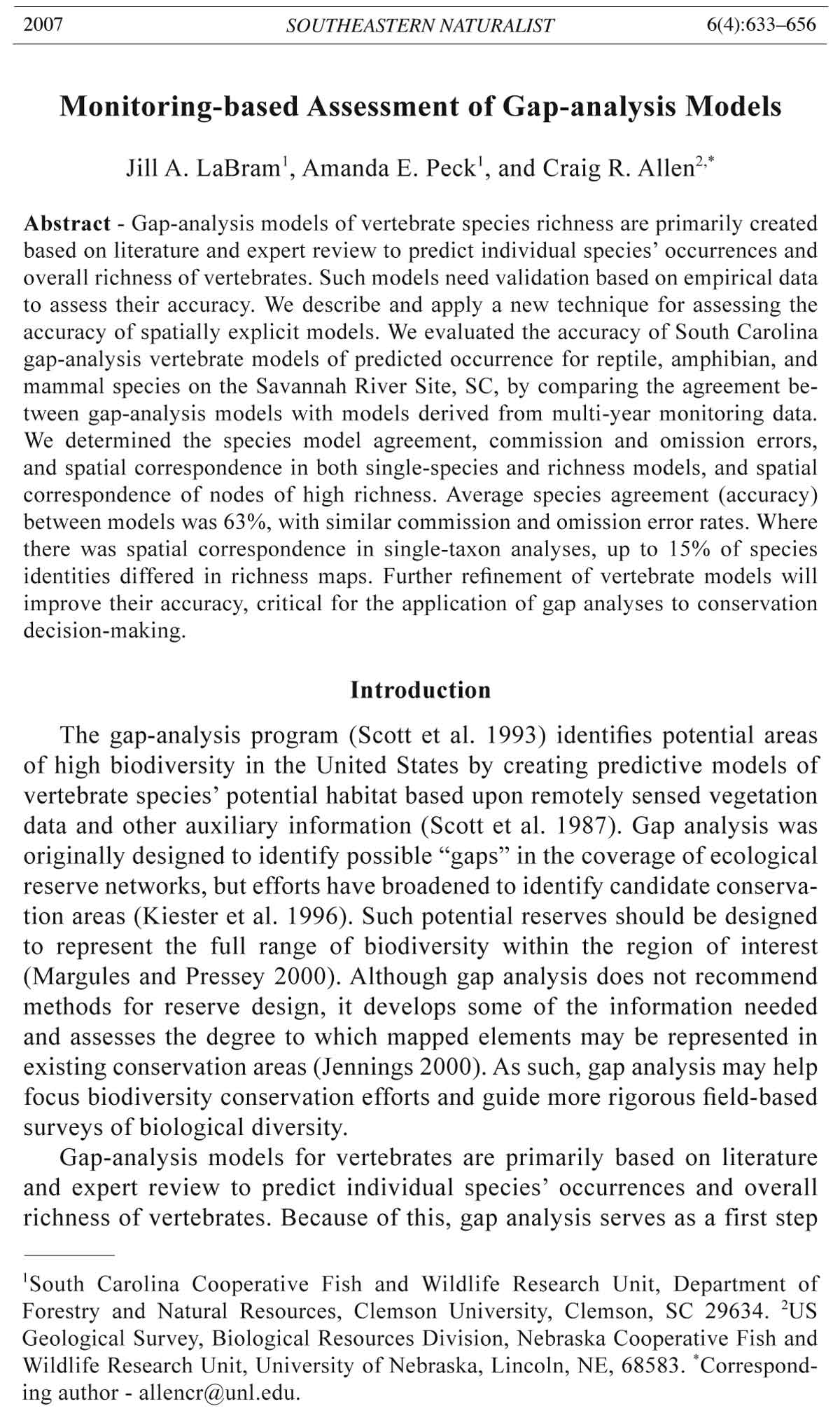
Figure 1 (opposite page, upper figure). The land-cover classification for the 78,000-
ha Savannah River Site (SRS), SC, modified from Imm (1997). We sampled
herpetofauna and mammals in five replicates of each of the seven land-cover classes
for three and five years, respectively.
Figure 2 (opposite page, lower figure). Land-cover classification of the 78,000-ha Savannah
River Site (SRS) area as classified by the South Carolina Gap Analysis Program.
2007 J.A. LaBram, A.E. Peck, and C.R. Allen 635
636 Southeastern Naturalist Vol. 6, No. 4
We utilized gap-analysis vertebrate models and multi-year monitoring
data to: (1) describe new methods for accuracy assessment, (2) assess the
agreement of gap-analysis vertebrate models of reptile and amphibian (herpetofauna)
and mammal species richness with sampling-based models, and
(3) determine the spatial correspondence between the nodes of highest richness
for predicted and sampling-based models.
Study Area
Our study site was located within the 78,000-ha Savannah River Site
(SRS), near Aiken, SC (Figs. 1 and 2). When the SRS was acquired in 1950
by the Department of Energy as a nuclear production facility, 67% was forested
and 33% was agricultural. All forest stands, except those with limited
access on the floodplain, had been logged (Workman and McLeod 1990).
The site was closed to the public in 1951, and the USDA Forest Service
planted pine seedlings on former crop and pastureland, beginning in 1952,
as an initial forest restoration effort. By 1963, about 90% of the area was
covered by young forests (Golley et al. 1965). Currently, 95% of the site is
covered with pine and hardwood forests and wetland habitats (Gibbons et
al. 1997).
Methods
We used multi-year monitoring data to determine vertebrate distributions,
against which we compared gap-analysis predictive models. We assessed
the accuracy (model agreement, omission and commission errors) of the
gap-analysis predictive models by comparing them with a model based on
monitoring data for individual species, by taxon, and for all species, and also
by comparing the spatial correspondence of species richness. Comparisons
between gap analysis and monitoring models were made with two different
base maps to determine if there was a change in error rates when using different
land-cover classifications. We used a SRS region map developed by Imm
(1997) (Fig. 1) and the South Carolina gap-analysis land-cover classification
map (Fig. 2) for the same landscape.
Vertebrate sampling
We trapped herpetofauna and small mammals at five randomly chosen
replicates of each of the seven major SRS land-cover types (Workman and
McLeod 1990). The locations of our sites were selected randomly, and trap
lines began >30 m from an edge (generally a gravel road). Small mammals
were sampled on each replicate during the fall season for five years
(1999–2003) utilizing Sherman live traps, tomahawk traps, and pitfall/drift
fence arrays (Fig. 3). Herpetofauna were sampled during the fall of three
years (2001–2003) and two summer seasons (2002, 2003) using pitfall/drift
fence arrays, funnel traps, coverboards, PVC pipes, and visual (incidental)
captures (Fig. 3).
2007 J.A. LaBram, A.E. Peck, and C.R. Allen 637
Mammals. Mammal traps were opened nightly and checked daily for three
consecutive days, twice a season. Paired Sherman live traps were placed at
10-m intervals along three parallel 150-m trap lines that were placed 30 m
apart, for a total of 96 Sherman traps per trapping period. Tomahawk box
traps were placed to sample medium-sized carnivores and omnivores (a total
of 12 tops/transect) at 30-m intervals along the outer-two Sherman trap lines.
At 50-m intervals along the center trap line, pitfall/drift fence arrays were
established between two Sherman lines to sample shrews and mice (a total
of 3 arrays/transect, 4 buckets per array, resulting in 12 pitfall traps). Drift
fences were constructed using 50-cm high aluminum flashing, and 19-liter
plastic buckets served as pitfalls (Gibbons and Bennet 1974). Small mammals
were identified to species and marked with individually numbered
0.635-cm Monel fish and small-mammal ear tags, and meso-mammals were
marked with spray paint.
Herpetofauna. Herpetofauna were sampled for nine consecutive days,
twice per season. A double-ended funnel trap constructed from hardware
cloth was placed in the middle of each segment of each pitfall-drift fence
Figure 3. Within-replicate design of mammal and herpetofauna trapping within each
of the 35 study areas (five replicates of seven land-cover types) at the Savannah River
Site. Mammals were captured using Sherman traps (96), tomahawk traps (12), and
three pitfall/drift-fence arrays (12 total buckets). Herpetofauna were captured using
pitfall traps (12 buckets), funnel traps (9), PVC pipes (6), and coverboards (8). Visual
captures were also recorded.
638 Southeastern Naturalist Vol. 6, No. 4
array, totaling nine funnel traps per site. Eight cover boards were placed at
each site, and were set in two arrays. Cover boards were 61- x 122-cm sheets
of tin or plywood, and each array consisted of two tin and two plywood
cover boards. We used PVC pipes (6 per site) to sample herpetofauna species
(mainly treefrogs) that escape pitfall traps and may not be commonly found
using cover boards. Pipes were 1.5-m sections of opaque white 3.2-cm diameter
PVC pipe inserted upright into the ground. Visual captures also were
recorded. Amphibians and reptiles were identified and marked with visible
implant fluorescent elastomer or were toe-clipped.
Land-cover data
SRS land cover. Landscape features within the Savannah River Site
(e.g., topography, geomorphologial classification, soil classification) were
used to develop an ecological classification GIS coverage in ArcView
(Imm 1997). We modified Imm’s (1997) land-cover classification by
grouping similar land-cover classes (e.g., southern mixed hardwood,
pine hardwood, and pine-bay hardwood forest were all classified as
mixed forest) into seven distinct vegetation types: bottomland hardwood,
swamp-edge, mixed forest, hardwood slope, planted pine, Carolina bay,
and sandhill (Fig. 1). Workman and McLeod (1990) describe the vegetation
characteristics of these classes.
Gap-analysis land cover. Between August and December 2001, 758
polygons were surveyed using a combination of remote sensing image interpretation
and ground truthing to compile the dominant land covers of South
Carolina. A 27-class raster habitat-based classification with a resolution
of 30 m was produced from Landsat TM imagery dating from 1991–1993
(Schmidt et al. 2001). The Savannah River Site area was clipped from the
South Carolina gap-analysis map. The SRS area included 22 of the 27 gap
analysis land-cover classes (Fig. 2), but only 10 classes were applicable to
our terrestrial-based study: swamp, bottomland/floodplain forest, closedcanopy
evergreen forest/woodland, needle-leaved evergreen mixed forest/
woodland, pine woodland, dry deciduous forest/woodland, mesic deciduous
forest/woodland, dry mixed forest/woodland, mesic mixed forest/woodland,
and wet evergreen. These classes are described on the gap-analysis website:
ftp://ftp.gap.uidaho.edu/products/South_Carolina/gis/landcover/grid/
scgapveg2.html.
The gap-analysis habitat classification differed from the SRS classification
because the different maps were developed for different uses. Neither
classification is correct or incorrect, but they differ in their aggregation and
delineation of land-cover categories. Therefore, we created a crosswalk table
that converted gap-analysis classes into SRS classes (Appendix 1) to provide
comparison between models based on the two classification systems using
SRS land cover as the base map. SRS classes also were cross-walked into
gap-analysis classes using the latter as the base map to determine how errors
were affected by the classification schemes.
2007 J.A. LaBram, A.E. Peck, and C.R. Allen 639
Models
Monitoring-based models. This study focused on terrestrial species;
therefore, our capture data apply to a 200-m swamp-edge buffer rather than
the entire swamp class at SRS. Because gap analysis is more effective in
modeling common, abundant species (Boone and Krohn 1999), and because
general trapping techniques such as we employed are also more likely to
sample common species, we limited the species we modeled to those which
were commonly captured. We modeled mammal and reptile species with
a minimum of 20 captures and amphibian species with a minimum of 35
captures. We set a criteria that captures within a given land-cover class must
account for ≥5% of the captures for a species for it to be considered “present”
in that land-cover class (Martin and McComb 2003). Trapping effort
was equal in all replicates and land-cover classes. Thirty-one species met our
criteria, including 10 reptiles, 13 amphibians, and 6 mammals (Table 1).
We created a species-habitat matrix of presence/absence for each species
in each land-cover class based on our monitoring data, with a value of “1”
designating presence and a value of “0” designating absence of a species.
This matrix was created using both the SRS and gap-analysis base maps.
Gap-analysis-based models. Gap-analysis-generated habitat affinities for
herpetofauna and mammals were developed primarily from literature review
and obtained from the South Carolina Department of Natural Resources
(Schmidt et al. 2001). These animal-habitat associations also were crosswalked
into SRS land-cover classes. This information was used to build a
matrix of species versus land-cover class for our 31 focal species. These
species were predicted to be present (value of “1”) or absent (value of “0”)
in each land-cover type.
Commission and omission errors
Agreement, commission, and omission error rates were calculated
for individual species and averaged by taxon for each base map by area
and land-cover class. Rates were then calculated within each land cover
and across the Savannah River Site. An area or land-cover type was in
spatial agreement between the gap analysis and monitoring-based models
if both predicted the species to be either present or absent within that landcover
type or area.
Spatial correspondence. Composite raster species richness maps for
amphibian, reptile, mammal, and combined taxa were produced by adding
the individual species models to produce a composite map of overall monitoring-
based richness, and predicted richness for the gap-analysis models.
We compared the gap analysis predictive model to our monitoring-based
model, using both the SRS and gap analysis land-cover classifications as
our base maps to determine spatial correspondence of species richness. The
monitoring-based richness model was subtracted from the gap-analysis
predicted-richness model. A value of 0 occurred and was defined as spatial
640 Southeastern Naturalist Vol. 6, No. 4
correspondence when the number of species predicted to occur in a landcover
class equaled the number of species that occurred based on field
monitoring. Positive values occurred where gap analysis predicted species
richness was greater than capture richness (commission errors), and negative
values occurred where capture richness was greater than gap analysis
predicted species richness (omission errors) (Allen et al. 2001a).
One of the explicit focuses of gap analysis is not single-species models,
but rather the identification of areas with potentially high species
richness. Thus, we determined land-cover classes representing nodes of
high species richness or “hotspots” (i.e., richness values ≥ 80% of the
maximum possible richness; Allen et al. 2001a) for sample-based and
gap-analysis models, using both the SRS and gap-analysis base maps.
Table 1. Common herpetofauna and mammal species sampled in five replicates of seven landcover
classes of the Savannah River Site, SC, for three and five years, respectively.
Common name Scientific name
Amphibians
Southern Cricket Frog Acris gryllus Le Conte
Marbled Salamander Ambystoma opacum Gravenhorst
Mole Salamander Ambystoma talpoideum Holbrook
Tiger Salamander Ambystoma tigrinum Green
Southern Toad Bufo terrestris Bonnaterre
Eastern Narrow-mouthed Toad Gastrophryne carolinensis Holbrook
Green Treefrog Hyla cinerea Schneider
Squirrel Treefrog Hyla squirrella Bosc
Slimy Salamander Plethodon glutinosus Green (complex)
Spring Peeper Pseudacris crucifer Wied-Neuwied
Green Frog Rana clamitans Latreille
Southern Leopard Frog Rana sphenocephala Harlan
Eastern Spadefoot Toad Scaphiopus holbrooki Harlan
Reptiles
Green Anole Anolis carolinensis Voigt
Six-lined Racerunner Cnemidophorus sexlineatus Linnaeus
Black Racer Coluber constrictor Linnaeus
Ringneck Snake Diadophis punctatus Linnaeus
Five-lined Skink Eumeces fasciatus Linnaeus
Broadhead Skink Eumeces laticeps Schneider
Fence Lizard Sceloporus undulatus Bosc and Daudin
Ground Skink Scincella lateralis Say
Redbelly Snake Storeria occipitomaculata Storer
Southeastern Crowned Snake Tantilla coronata Baird and Girard
Mammals
Southern short-tailed shrew Blarina carolinensis Bachman
Least shrew Cryptotis parva Say
Opossum Didelphis virginiana Kerr
Eastern woodrat Neotoma floridana Ord
Golden mouse Ochrotomys nuttali Harlan
Cotton mouse Peromyscus gossypinus LeConte
Raccoon Procyon lotor Linnaeus
Southeastern shrew Sorex longirostris Bachman
2007 J.A. LaBram, A.E. Peck, and C.R. Allen 641
Using this criteria, a land-cover class would be considered a “hotspot” if
80% of the species occurred or a “predicted hotspot” if 80% of the species
were predicted to occur (i.e., 11 of the 13 amphibians, 8 of the 10 reptiles,
7 of the 8 mammals, or 25 of 31 total species). We then determined the
correspondence between these actual and predicted nodes of highest richness
for each taxon and combined taxa in each base map.
Results
Vertebrate sampling
Models based on SRS land cover. We captured, marked, and released
23,105 individuals of 69 herpetofauna species and 1142 individuals of 16
mammal species. Species richness based on our sampling varied from 2–12
species per land-cover type for amphibians, 6–10 species for reptiles, 2–8
species for mammals, and 11–28 species for all taxa (Table 2). Gap-analysis-
predicted species richness ranged from 5–13 species for amphibians,
2–10 species for reptiles, 3–8 species for mammals, and 10–31 for all taxa
(Table 2).
Models based on gap analysis land cover. Species richness based on
our monitoring program varied from 2–11 species per land-cover type for
amphibians, 7–10 species for reptiles, 2–7 species for mammals, and 11–28
species for all taxa (Table 3). Gap-analysis-predicted species richness varied
from 5–13 species for amphibians, 2–10 species for reptiles, 3–8 species for
mammals, and 9–30 species for all taxa (Table 3).
Agreement: Commission and omission errors
SRS land cover as a base map. Average amphibian accuracy was 68%,
and commission errors occurred more often than omission errors in both area
and land-cover comparisons (Table 4). Amphibians were most accurately
predicted in Carolina bays (92%) and least accurately in sandhills (15%, due
to commission error) (Table 2). Average reptile accuracy was 69%. Omission
errors occurred more often than commission errors by both area and
land cover. The highest reptile accuracy of gap-analysis-predicted models
was found in hardwood slope and mixed forest (90%), and the lowest accuracy
was in planted pine (40%, due to omission error). Average accuracy
of gap-analysis mammal models was 64%, and omission and commission
error rates were more or less equivalent by both area and land cover. The
highest accuracy of gap-analysis-predicted mammal models was for bottomland
hardwood (100%), and presence or absence was predicted poorly in
sandhills (38%, due to commission error). Overall, individual-species models
were on average accurate 67% of the time. Commission errors averaged
18% and omission errors averaged 14% for all species. The highest accuracy
for all species predicted was bottomland hardwood (87%), while presence
or absence of each species was predicted poorly in sandhills (39%, due to
commission error).
642 Southeastern Naturalist Vol. 6, No. 4
Table 2. Species occurrence at the Savannah River Site (SRS) based on multi-year monitoring
models and gap-analysis models, using SRS land cover as a base map. A “1” indicates species
presence and a “0” indicates absence. The first number in each column shows presence or
absence of a species based on monitoring data. The second number in each column shows the
gap-analysis-predicted presence or absence of a species in each land-cover class. Agreement
occurs when gap-analysis predictions correspond with capture data for presence or absence of
a species. Omission errors occur when gap analysis predicts a species to be absent when it was
actually present. Commission errors occur when gap analysis predicts a species to be present
and it was absent based on capture data.
Species BLH1 BAY HWS MIX PPI SDH SWA
Amphibians
Southern Cricket Frog 1/1 1/1 1/1 1/1 0/1 0/1 1/1
Green Frog 1/1 1/1 1/1 1/1 1/0 0/1 1/1
Southern Leopard Frog 1/1 1/1 1/1 1/1 1/0 0/1 1/1
Spring Peeper 1/1 1/1 0/1 0/1 0/0 0/1 1/1
Squirrel Treefrog 1/1 0/1 1/1 0/1 0/0 0/1 1/1
Green Treefrog 1/1 1/1 1/0 1/1 0/0 0/1 1/1
Southern Toad 1/1 1/1 1/1 1/1 1/1 0/1 1/1
Eastern Narrow-mouthed Toad 0/1 1/1 1/1 1/1 1/1 0/1 1/1
Eastern Spadefoot Toad 0/1 1/1 1/1 1/1 1/1 1/1 1/1
Marbled Salamander 1/1 1/1 0/1 1/1 0/0 0/1 1/1
Mole Salamander 1/1 1/1 0/0 0/1 1/0 0/1 0/1
Tiger Salamander 1/1 1/1 0/0 0/1 1/0 0/1 0/1
Amphibian totals 11/13 12/13 9/10 9/13 7/5 2/13 11/13
% amphibian agreement 85 92 77 69 54 15 85
% omission error 0 0 8 0 31 0 0
% commission error 15 8 15 31 15 85 15
Reptiles
Green Anole 1/1 1/1 1/1 1/1 1/0 1/1 1/1
Six-Lined Racerunner 0/0 0/0 0/1 0/1 1/0 1/1 1/0
Five-Lined Skink 1/1 0/0 1/1 1/1 1/0 0/1 1/0
Broadhead Skink 1/1 0/1 1/1 1/1 1/0 0/1 1/1
Ground Skink 1/1 1/1 1/1 1/1 1/1 1/1 1/1
Fence Lizard 0/1 0/0 1/1 1/1 1/0 1/1 1/0
Black Racer 1/1 1/1 1/1 1/1 1/1 1/1 1/1
Ringneck Snake 1/1 1/0 1/1 1/1 0/0 1/1 1/1
Redbelly Snake 1/0 1/0 1/1 1/1 0/0 0/1 1/0
Southeastern Crowned Snake 0/0 1/0 1/1 1/1 1/0 1/1 1/0
Reptile totals 7/7 6/4 9/10 9/10 8/2 7/10 10/5
% reptile agreement 80 60 90 90 40 70 50
% omission error 10 30 0 0 60 0 50
% commission error 10 10 10 10 0 30 0
Mammals
Southern short-tailed shrew 1/1 1/1 1/1 1/1 1/0 0/1 1/0
Southeastern shrew 1/1 1/1 1/1 1/1 1/1 0/1 1/1
Least shrew 0/0 1/0 1/0 1/1 1/0 0/1 1/0
Golden mouse 1/1 1/0 0/1 1/1 1/1 0/1 1/1
Cotton mouse 1/1 1/0 0/1 1/1 1/0 1/1 1/1
Woodrat 1/1 1/0 1/1 0/1 0/0 0/0 0/1
Opossum 1/1 1/1 1/1 1/1 1/1 0/1 1/1
Raccoon 1/1 1/1 1/1 1/1 1/0 1/1 1/1
Mammal totals 7/7 8/4 6/7 7/8 7/3 2/7 7/6
% mammal agreement 100 50 63 88 50 38 63
% omission error 0 50 13 0 50 0 25
% commission error 0 0 25 13 0 63 13
2007 J.A. LaBram, A.E. Peck, and C.R. Allen 643
Gap-analysis land cover as a base map. Average amphibian accuracy was
55%, and commission errors occurred more than omission errors by both area
and land cover (Table 4). Amphibian species were most accurately predicted
in swamp-edge and bottomland/floodplain forest classes (85%), and were
least accurate in pine woodland (15%, due to commission error) (Table 3). The
Table 2, continued.
Species BLH1 BAY HWS MIX PPI SDH SWA
All species
Vertebrate totals 25/27 26/21 24/27 25/31 22/10 11/30 28/24
% species agreement 87 71 77 81 48 39 68
% omission error 3 23 6 0 45 0 23
% commission error 10 6 16 19 6 61 10
1BLH = bottomland hardwood, BAY = Carolina bay, HWS = hardwood slope, MIX = mixed
forest, PPI = planted pine, SDH = sandhill, SWA = swamp-edge.
Figure 4. Spatial correspondence of species richness between gap-analysis-predicted
occurrence and monitoring-based occurrence using Savannah River Site (SRS) land
cover as the base map. Models of the presence of individual species were summed to
get a total richness by land-cover class for predicted and actual occurrence. Captured
richness was subtracted from predicted richness for each land-cover class. Negative
values represent land-cover classes in which captured species richness was greater
than predicted species richness. Positive values represent land-cover classes in which
predicted species richness was greater than captured species richness. A zero would
occur if gap analysis predicted the same number of species to be present that actually
were based on capture data in that land-cover class.
644 Southeastern Naturalist Vol. 6, No. 4
Table 3. Species occurrence at the Savannah river Site (SRS) based on multi-year monitoring
models and gap-analysis models, using gap-analysis land-cover as a base map. A “1” indicates
species presence and a “0” indicates absence. The first number in each column shows the
presence or absence of a species based on monitoring data. The second number in each column
shows the predicted presence or absence of a species by gap analysis in each land-cover
category. Agreement occurs when gap-analysis predictions correspond with capture data for
presence or absence of a species. Omission errors occur when gap analysis predicts a species to
be absent when it was actually present. Commission errors occur when gap analysis predicts a
species to be present and it was absent based on capture data.
Species S1 BF/F CCEF NEMF PW DDF MDF DMF MMF WE
Amphibians
Southern Cricket Frog 1/1 1/1 0/1 0/1 0/1 1/0 1/1 1/0 1/1 1/0
Green Frog 1/1 1/1 1/0 0/1 0/1 1/0 1/1 1/0 1/1 1/0
Southern Leopard Frog 1/1 1/1 1/0 0/1 0/1 1/0 1/1 1/0 1/1 1/0
Spring Peeper 1/1 1/1 0/0 0/1 0/1 0/0 0/1 0/0 0/1 1/1
Squirrel Treefrog 1/1 1/1 0/0 0/1 0/1 1/1 1/1 0/1 0/1 1/1
Green Treefrog 1/1 1/1 0/0 0/0 0/1 1/0 1/0 1/0 1/1 1/0
Southern Toad 1/1 1/1 1/1 0/1 0/1 1/1 1/1 1/1 1/1 1/0
Eastern Narrow-mouthed Toad 1/1 0/1 1/1 0/1 0/1 1/1 1/1 1/1 1/1 0/0
Eastern Spadefoot Toad 1/1 0/1 1/1 1/1 1/1 1/1 1/1 1/1 1/1 0/0
Marbled Salamander 1/1 1/1 0/0 0/1 0/1 0/1 0/1 1/1 1/1 1/0
Mole Salamander 0/1 1/1 1/0 0/1 0/1 0/0 0/0 0/1 0/1 1/1
Tiger Salamander 0/1 1/1 1/0 0/1 0/1 0/0 0/0 0/1 0/1 1/0
Slimy Salamander 1/1 1/1 0/1 1/1 1/1 1/1 1/1 1/1 1/1 1/0
Amphibian totals 11/13 11/13 7/5 2/12 2/13 9/6 9/10 9/8 9/13 11/3
% amphibian agreement 85 85 54 23 15 62 77 46 69 38
% omission error 0 0 31 0 0 31 8 31 0 62
% commission error 15 15 15 77 85 8 15 23 31 0
Reptiles
Green Anole 1/1 1/1 1/0 1/1 1/1 1/1 1/1 1/0 1/1 1/0
Six-lined Racerunner 1/0 0/0 1/0 1/1 1/1 0/0 0/0 0/0 0/0 0/0
Five-lined Skink 1/0 1/1 1/0 0/1 0/1 1/0 1/1 1/0 1/1 1/0
Broadhead Skink 1/1 1/1 1/0 0/0 0/1 1/0 1/1 1/0 1/1 1/0
Ground Skink 1/1 1/1 1/1 1/1 1/1 1/1 1/1 1/1 1/1 1/0
Fence Lizard 1/0 0/0 1/0 1/1 1/1 1/1 1/0 1/1 1/0 0/1
Black Racer 1/1 1/1 1/1 1/1 1/1 1/1 1/1 1/1 1/1 1/1
Ringneck Snake 1/1 1/1 0/0 1/1 1/1 1/0 1/1 1/0 1/1 1/1
Redbelly Snake 1/0 1/0 0/0 0/1 0/1 1/0 1/1 1/0 1/1 1/0
Southeastern Crowned Snake 1/0 0/0 1/0 1/1 1/1 1/1 1/0 1/1 1/0 0/0
Reptile totals 10/5 7/6 8/2 7/9 7/10 9/5 9/7 9/4 9/7 7/3
% reptile agreement 50 90 40 80 70 60 80 50 80 40
% omission error 50 10 60 0 0 40 20 50 20 50
% commission error 0 0 0 20 30 0 0 0 0 10
Mammals
Southern short-tailed shrew 1/0 1/1 1/0 0/0 0/1 1/0 1/1 1/0 1/1 1/0
Southeastern shrew 1/1 1/1 1/1 0/1 0/1 1/0 1/1 1/0 1/1 1/1
Least shrew 1/0 0/0 1/0 0/1 0/1 1/0 1/0 1/0 1/1 0/0
Golden mouse 1/1 1/1 1/1 0/1 0/1 0/1 0/1 1/1 1/1 1/0
Cotton mouse 1/1 1/1 1/0 1/1 1/1 0/1 0/1 1/1 1/1 1/0
Woodrat 0/1 1/1 0/0 0/0 0/0 1/1 1/1 0/1 0/1 1/0
Opossum 1/1 1/1 1/1 0/1 0/1 1/1 1/1 1/1 1/1 1/1
Raccoon 1/1 1/1 1/0 1/1 1/1 1/1 1/1 0/1 0/1 1/1
Mammal totals 7/6 7/7 7/3 2/6 2/7 6/5 6/7 6/5 6/8 7/3
% mammal agreement 63 100 50 50 38 38 63 38 75 50
% omission error 25 0 50 0 0 38 13 38 0 50
% commission error 13 0 0 50 63 25 25 25 25 0
All Species
Vertebrate totals 28/24 25/26 22/10 11/27 11/30 24/16 24/24 24/17 24/28 25/9
% agreement 68 90 48 48 39 55 74 45 74 42
% omission error 23 3 45 0 0 35 13 39 6 55
% commission error 10 6 6 52 61 10 13 16 19 3
2007 J.A. LaBram, A.E. Peck, and C.R. Allen 645
Table 3, continued.
1S = swamp-edge, BF/F = bottomland floodplain forest, CCEF = closed canopy evergreen forest/
woodland, NEMF = needle-leaved evergreen mixed forest/woodland, PW = pine woodland,
DDF = dry deciduous forest/woodland, MDF = mesic deciduous forest/woodland, DMF = dry
mixed forest/woodland, MMF = mesic mixed forest/woodland, WE = wet evergreen.
Table 4. Agreement, omission, and commission errors for each species in two categories:
number of land-cover classes and area of land-cover classes. Omission errors occur when gap
analysis predicts a species to be absent when it was present based on monitoring models, and
commission errors occur when gap analysis predicts a species to be present when it was absent
based on monitoring models. Percent agreement, omission, and commission were calculated by
dividing the respective number of land-cover classes or area by the total # of land-cover classes
or area in each base map. The first number in each column represents the percent agreement,
omission or commission using the Savannah River Site (SRS) land-cover classification. The
second number represents the same calculations for the gap analysis land-cover classification.
% OE = percent omission error, % CE = percent commission error.
Landcover Area
% landcover % area
Common name agreement % OE % CE agreement % OE % CE
Southern Cricket Frog 71/40 0/30 29/30 39/23 0/2 61/75
Green Frog 71/40 14/40 14/20 39/23 36/56 25/21
Southern Leopard Frog 71/40 14/40 14/20 39/23 36/56 25/21
Spring Peeper 57/60 0/0 43/40 57/72 0/0 43/28
Squirrel Treefrog 57/60 0/0 43/40 61/78 0/0 39/22
Sreen Treefrog 71/50 14/40 14/10 70/92 5/8 25/0
Southern Toad 86/70 0/10 14/20 75/79 0/0 25/21
Eastern Narrow-mouthed Toad 71/70 0/0 29/30 60/68 0/0 40/32
Eastern Spadefoot Toad 86/90 0/0 14/10 85/89 0/0 15/11
Marbled Salamander 71/50 0/10 29/40 70/71 0/0 30/29
Mole Salamander 43/40 14/10 43/50 21/19 36/54 43/27
Tiger Salamander 43/30 14/20 43/50 21/19 36/54 43/27
Slimy Salamander 86/80 0/10 14/10 64/46 0/0 36/54
Green Anole 86/70 14/30 0/0 64/46 36/54 0/0
Six-lined Racerunner 43/80 29/20 29/0 41/40 41/60 18/0
Five-lined Skink 57/30 29/50 14/20 34/17 41/61 25/21
Broadhead Skink 57/50 14/40 29/10 38/44 36/56 26/0
Ground Skink 100/90 0/10 0/0 100/100 0/0 0/0
Fence Lizard 57/50 29/40 14/10 44/34 41/66 15/0
Black Racer 100/100 0/0 0/0 100/100 0/0 0/0
Ringneck Snake 86/80 14/20 0/0 99/98 1/2 0/0
Redbelly Snake 43/30 43/50 14/20 54/60 21/18 25/21
Southeastern Crowned Snake 57/60 43/40 0/0 58/34 42/66 0/0
Southern shorttail shrew 57/40 29/50 14/10 34/39 41/61 25/0
Southeastern shrew 86/60 0/20 14/20 75/77 0/2 25/21
Least shrew 29/30 57/50 14/20 28/11 47/67 25/21
Golden mouse 57/50 14/10 29/40 69/71 1/0 30/29
Cotton mouse 57/60 29/20 14/20 58/38 37/54 5/8
Eastern woodrat 57/60 14/10 29/30 81/94 1/0 18/6
Opossum 86/80 0/0 14/20 75/79 0/0 25/21
Raccoon 86/70 14/10 0/20 64/46 36/54 0/0
Average amphibian agreement 68/55 6/16 26/28 54/54 12/18 35/28
Average reptile agreement 69/64 21/30 10/6 63/57 26/38 11/4
Average mammal agreement 64/56 20/21 16/23 61/57 21/30 19/13
Average agreement by species 67/58 14/22 18/20 59/47 19/23 23/30
646 Southeastern Naturalist Vol. 6, No. 4
highest reptile accuracy of gap analysis-predicted models was found in bottomland
floodplain (90%), and the lowest accuracy was in wet evergreen and
2007 J.A. LaBram, A.E. Peck, and C.R. Allen 647
closed-canopy evergreen forest classes (40%). Average reptile accuracy was
64%, and there were more omission errors than commission errors by both
area and land cover. Average mammal accuracy was 56%, and omission errors
were higher than commission errors by area comparison and lower by land
Figure 5 (opposite page, upper figure). Spatial correspondence between nodes of
highest richness (hotspots) predicted by gap analysis and those hotspots that occurred
based on monitoring data using the Savannah River Site (SRS) land-cover classification
as a base map. For a land-cover class to be considered a node of high richness, a
minimum 25 of the 31 vertebrate species (top 20%) was required to be present.
Figure 6 (opposite page, lower figure). Spatial correspondence of species richness
between gap-analysis-predicted occurrence and occurrence derived from monitoring
data, using the gap-analysis land-cover as the base map. Models of the presence
of individual species were summed to get a total richness by land-cover class.
Monitoring-based richness models were subtracted from predicted richness for each
land-cover class. Negative values represent land-cover classes in which captured species
richness was greater than predicted species richness. Positive values represent
land-cover classes in which predicted species richness was greater than captured
species richness. A zero would occur if gap analysis predicted the same number of
species to be present as were detected with multi-year monitoring.
Figure 7. Spatial correspondence between nodes of highest richness (hotspots) predicted
by gap analysis and those derived from multi-year monitoring, using the gap
analysis land cover. For a land-cover class to be considered a node of high richness,
a minimum of 25 of the 31 vertebrate species (top 20%) was required.
648 Southeastern Naturalist Vol. 6, No. 4
cover. Mammal species were predicted with 100% accuracy in bottomland/
floodplain, and were predicted least accurately in three land covers (38% in
pine woodland, dry deciduous forest, and mesic deciduous forest). Individual
models were on average accurate 58% of the time. For all species, commission
errors averaged 20%, and omission errors averaged 22%. Accuracy ranged
from 90% in bottomland floodplain forest to 39% in pine woodland.
Spatial correspondence
SRS land cover as a base map. Predicted amphibian species richness was
higher than monitoring-based richness in all but the planted pine land-cover
class. These predictions ranged from a single commission error in Carolina bay
and hardwood slope classes to 11 more species predicted to occur than were
captured in the sandhill class. Additionally, there was no spatial correspondence
between the number of species captured and those predicted by gap analysis for
amphibians. However, three monitoring-based hotspots corresponded to predicted
hotspots (bottomland hardwood, Carolina bay, and swamp-edge), with
85% overlap in predicted and actual species composition (Table 2).
For reptiles, correspondence occurred in the bottomland hardwood class
(7 species), with an 80% agreement of species composition (i.e., Fence Lizard
was predicted to occur, but did not based on monitoring, and the Redbelly
Snake was captured but not predicted to occur in gap-analysis models). Reptile
species richness ranged from three more species predicted in the sandhill landcover
class to 6 more species sampled than predicted in the planted pine class.
Two monitoring-based reptile hotspots corresponded to predicted hotspots
(hardwood slope and mixed forest), with 90% agreement in predicted and
monitoring-based species composition.
Mammal richness corresponded in the bottomland hardwood class
with all 8 species predicted to occur correctly. The sandhill class differed
the most, with 5 more species predicted to occur than were actually
sampled. Four more species were documented during monitoring than
were predicted in gap-analysis models in the Carolina bay class. Bottomland
hardwood and mixed forest classes corresponded as mammal
hotspots to those predicted by gap analysis. The remaining classes were
either predicted to be a hotspot (sandhill and hardwood slope) or were a
monitoring-based hotspot (Carolina bay, planted pine, and swamp-edge),
but did not correspond (Table 2).
There was no spatial correspondence between monitoring-based and
gap-analysis-predicted models for all taxa (Fig. 4). Differences ranged
from 19 more species predicted than were documented in the sandhill
land-cover class to 12 more species occurring than were predicted in the
planted pine class. All 31 species were predicted to occur in the mixed
forest class, while 25 actually occurred based on monitoring, qualifying
this land cover as a monitoring-based and predicted hotspot. Predicted
and monitoring-based hotspot correspondence also occurred in the
2007 J.A. LaBram, A.E. Peck, and C.R. Allen 649
bottomland hardwood class. Gap analysis predicted hardwood slope and
sandhill classes as vertebrate hotspots, whereas Carolina bay and swampedge
classes were identified as monitoring-based hotspots. The planted
pine class did not qualify as a hotspot based on monitoring nor was it predicted
to be one by gap analysis (Fig. 5).
Gap-analysis land cover as a base map. There was no correspondence
of amphibian species richness between monitoring-based models and those
predicted by gap analysis. Differences ranged from 11 and 10 more species
predicted than sampled in pine woodland and needle-leaved evergreen
mixed forest/woodland, respectively, to 8 more species documented than
predicted in wet evergreen. Two monitoring-based hotspots corresponded to
predicted hotspots for amphibians (swamp-edge and bottomland floodplain
forest), with an 85% agreement in predicted and actual species composition
(Table 3).
There was no correspondence of reptile species richness between the
monitoring-based models and those predicted by gap analysis. Predicted
reptile richness was higher than the monitoring-based richness in only 2
classes (by 2 species in needle-leaved evergreen mixed forest/woodland and
by 3 species in dry deciduous forest). These two classes were predicted as
hotspots, but did not correspond to the 6 monitoring-based hotspots. Monitoring-
based richness ranged from 6 more species occurring than predicted
(closed canopy evergreen forest/woodland) to only 1 more species occurring
than predicted (bottomland floodplain forest).
Monitoring-based mammal richness corresponded to predicted richness
in the bottomland floodplain/forest class, with all species predicted
correctly. Five more species were predicted to occur in pine woodland
than were recorded based on monitoring, while 4 more species occurred
than were predicted in the closed canopy evergreen forest and wet evergreen
classes. The bottomland floodplain class was the only hotspot that was predicted
correctly based on monitoring.
Vertebrate species had spatial correspondence between predicted and
actual vertebrate occurrence in one land-cover class (mesic deciduous forest;
Fig. 6), with a 74% agreement in species composition. Differences ranged
from 19 more species predicted to occur in the pine woodland class to 16
more species occurring based on monitoring than predicted by gap analysis
in the wet evergreen class. Although gap analysis predicted four land-cover
classes as hotspots and three were identified based on monitoring, there was
only correspondence in the bottomland/floodplain class (Fig. 7).
Discussion
The best assessment of a model’s accuracy is validation with an independent
data set. Therefore, we compared South Carolina gap-analysis models
with models based on multi-year monitoring. Instead of assigning a priori
650 Southeastern Naturalist Vol. 6, No. 4
or likelihood of occurrence ranks to reduce commission errors based on the
likelihood-of-occurrence, we only modeled species that were commonly
captured. While likelihood-of-occurrence ranks methods may be useful in
assessing models when not much is known about the data used to inform
the model (e.g., the length of survey, size of study area, reliability of data
collected by multiple investigators), it was more appropriate in our study to
examine a subset of common species.
Our results are based on some key assumptions. One assumption is that
≥20 captures for mammals and reptiles and ≥35 captures for amphibians
was enough to build valid models. The second assumption is that modeling
a species as present in a land-cover class where it was captured is valid only
if ≥5% of the total captures for that species were in that land-cover class.
Both assumptions are attempts to remove uncommon or transient animals
from our models and ensure minimum data for model building. However,
failure to detect a species on a site may be due to trapping difficulty, natural
rarity, or spatial or temporal variability in habitat use rather than the absence
of the animal. We tested our assumptions by performing sensitivity
analyses that varyied the rules used. For both assumptions, we found that
our minimum rules provided a reasonable balance between omission and
commission error rates and number of species modeled (Figs. 8 and 9). Additionally,
the assessed accuracy of species models was not related to the
Figure 8. Impact of varying the required minimum number of individuals captured
(x-axis) on omission and commission error rates (y-axis). The solid darker gray
bars represent omission error rates, and the hatched bars represent commission error
rates. Twenty captures allowed for a compromise between error rate and number
of species modeled.
2007 J.A. LaBram, A.E. Peck, and C.R. Allen 651
number of individuals sampled for species captured ≥20 times (p > 0.05).
Another source of error for our monitoring models is differences in detection
probabilities for species in different land covers; we did not test for this.
However, our models and gap-analysis models are based on the presence or
absence of a species, rather than its abundance, and thus this source of error
should have been minimal for most species.
Classification schemes developed for different purposes and/or at different
scales aggregate within and among land-cover classes differently.
Thus, converting between classification systems can increase the commission
and omission errors of the models. There were several land-cover
types that were not clearly delineated in the South Carolina gap analysis,
which may have led to failure of animal-habitat associations to correctly
predict species occurrence. For example, South Carolina gap analysis could
not reliably separate the land-cover categories of swamp and bottomland
hardwood based on their techniques or decision rules (Schmidt et al. 2001).
Also, none of the 194 Carolina bays (786 ha) known to occur in the SRS
area were present on the South Carolina gap-analysis map; therefore, we
could not include that class in the gap-analysis-based model. Conversely,
the SRS seven-class land-cover classification scheme was simpler than the
gap analysis ten-class land-cover classification.
Figure 9. Impact of varying the minimum percent of captures required (x-axis) for a
species to be included in a land-cover class, on omission and commission error rates
(y-axis). The gray bars represent omission error rates, and the hatched bars represent
commission error rates. A 5% capture criteria balances omission and commission
error rates.
652 Southeastern Naturalist Vol. 6, No. 4
Omission and commission error rates may vary depending on whether
one calculates error rates based on land-cover classes or the area of agreement.
Species with the same land-cover class agreement rates may differ in
the area of agreement, so different calculations may be required based on
research or management objectives. A land cover that is large in size relative
to the landscape can influence error rates more than a small land cover, but
the small land cover may be more ecologically important. The sandhill and
planted pine land covers comprise almost two thirds of the SRS landscape,
so their high error rates (61% and 51%, respectively) contributed greatly to
reduce overall accuracy within our study area.
Average model agreement for the two base land-cover maps was
similar for both commission and omission error rates. Error rates were
similar for mammals, and omission errors were higher than commission
errors for reptiles. For amphibians, commission errors were higher than
omission errors, perhaps due to differences in detectability in this taxon.
The vertebrate species most accurately modeled in both land-cover maps
and methods of assessment were either habitat generalists (e.g., Coluber
Constrictor L. [Black Racer] and Didelphis virginiana Kerr [opossum])
or specialists (e.g., Neotoma floridana Ord [eastern woodrat]). Vertebrate
species with lowest model-agreement rates may interact with finer-scale
variables difficult to identify with remote sensing or may have lower detection
rates (e.g., Ambystoma talpoideum Holbrook [Mole Salamander]
and Cryptotis parva Say [least shrew]). Because gap analysis is a tool
for predicting vertebrate distributions for use in conservation planning,
Edwards et al. (1996) argues that commission error is preferred over
omission error. High omission error could possibly lead to the exclusion
of species from conservation plans. Incorporating uncertainty into gapanalysis
models would enhance their applicability.
One of the explicit focuses of gap analysis is to identify areas of potential
high biodiversity, so we determined which land-cover classes contained
these hotspots for each base map. There was some spatial correspondence
when conducting analyses for each taxon separately as well as vertebrates
as a whole, but correspondence was limited to three or fewer classes.
Where there was spatial correspondence for within-taxon analyses, species
identities often differed. This is important if managers are concerned with
conservation of a particular species, as opposed to species richness.
We do not present our results as a definitive accuracy assessment of
South Carolina gap analysis or gap analyses in general. The resolution
of vertebrate models in our analyses (30-m minimum mapping unit) is far
higher than recommended for final gap analysis products (EPA’s EMAP
hexagon; a 635-km2 hexagonal grid; White et al. 1992). Additionally,
the five-year span of our data is still relatively limited. Therefore, our accuracy
assessment of South Carolina gap-analysis models is presented
to demonstrate our methods, and is likely to underestimate the accuracy
of lower resolution models. By providing analyses based on both land2007
J.A. LaBram, A.E. Peck, and C.R. Allen 653
cover classifications utilized by managers in the region of our study area,
we demonstrate how the utilization of different classifications affects the
assessment of accuracy in animal-distribution modeling. Despite the disparate
classification systems used by the SRS maps and gap-analysis maps,
and the different uses for which these maps were created, error rates were
similar in our comparisons, though the sources of error differed.
One way to improve vertebrate models is to determine the sources of
errors. Two possible sources are erroneous habitat-association models, or
species models that are too simplistic. For the former problem, monitoring
and sampling programs can provide information with enough spatial
and temporal breadth to refine habitat-association models. In the latter
case, models can be improved utilizing current knowledge that blends
landscape ecology and population viability. Inclusion of landscape metrics
may improve species models and give the user more confidence in
management decisions based on output of the models. For example, Allen
et al. (2001b) incorporated minimum critical-area criteria into species
models to reduce commission errors arising from modeling an animal as
present in a patch too small or disconnected to support a viable population.
Most likely, commission errors propagate from a combination of
these sources. Explicit consideration of uncertainty in gap-analysis models
would be a great improvement. Our methods do provide an accuracy
assessment of gap-analysis models. Further refinement of the vertebratemodeling
process and investigation of sources of model error will
improve the accuracy of predictive models critical for the application of
gap analyses results to conservation decision making.
Acknowledgments
The South Carolina Cooperative Fish and Wildlife Research Unit is jointly supported
by a cooperative agreement among the United States Geological Survey,
the South Carolina Department of Natural Resources, Clemson University, and
the Wildlife Management Institute. The Nebraska Cooperative Fish and Wildlife
Research Unit is jointly supported by a cooperative agreement between the United
States Geological Survey, the Nebraska Game and Parks Commission, the University
of Nebraska-Lincoln, the United States Fish and Wildlife Service and the Wildlife
Management Institute. Funding was provided by the Department of Energy-Savannah
River Operations Office through the US Forest Service Savannah River under
Interagency Agreement DE-IA09-00SR22188. We would like to thank L. Moore,
W. Jarvis, and D. Imm for facilitating this project. J. Bock, S. Brobst, J. Cassell,
J. LaPointe, Q. Lupton, J. Oldroyd, B. Roberts, B. Schlachter, D. Schwalm, and B.
Timm aided in data collection. A. Garmestani, V. Egger, and B. Weeks reviewed an
earlier draft of this manuscript.
Literature Cited
Allen C.R., L.G Pearlstine, D.P. Wojcik, and W.M. Kitchens. 2001a. The spatial
distribution of diversity between disparate taxa: Spatial correspondence
between mammals and ants across south Florida, USA. Landscape Ecology
16:453–464.
654 Southeastern Naturalist Vol. 6, No. 4
Allen, C.R., L.G. Pearlstine, and W.M. Kitchens. 2001b. Modeling viable mammal
populations in gap analyses. Biological Conservation 99:135–144.
Boone, R.B., and W.B. Krohn. 1999. Modeling the occurrence of bird species: Are
the errors predictable? Ecological Applications 9:835–848.
Boone, R.B., and W.B. Krohn. 2000. Predicting broad-scale occurrences of vertebrates
in patchy landscapes. Landscape Ecology 15:63–74.
Edwards, T.C., Jr., E.T. Deshler., D. Foster, and G.G. Moisen. 1996. Adequacy of
wildlife habitat relation models for estimating spatial distributions of terrestrial
vertebrates. Conservation Biology 10:263–270.
Fielding, A.H. 2002. What are the appropriate characteristics of an accuracy measure?
Pp. 271–280, In J.M. Scott, P.J. Heglund, M.L. Morrison, J.B. Haufler,
M.G. Raphael, W.A. Wall, and F.B. Samson (Eds.). Predicting Species Occurrences.
Island Press, Washington, DC.
Gibbons, J.W., and D.H. Bennet. 1974. Determination of anuran terrestrial activity
patterns by a drift-fence method. Copeia 1:236–243.
Gibbons, J.W., V.J. Burke, J.E. Lovich, R.D. Semlitsch, T.D. Tuberville, J.R. Bodie,
J.L. Greene, P.H. Niewiarowski, H.H. Whiteman, D.E. Scott, J.H.K. Pechmann,
C.R. Harrison, S.H. Bennett, J.D. Krenz, M.S. Mills, K.A. Buhlmann, J.R. Lee,
R.A. Seigel, A.D. Tucker, T.M. Mills, T. Lamb, M.E. Dorcas, J.D. Congdon,
M.H. Smith, D.H. Nelson, M.B. Dietsch, H.G. Hanlin, J.A. Ott, and D.J. Karapatakis.
1997. Perceptions of species abundance, distribution, and diversity:
Lessons from four decades of sampling on a government managed reserve. Environmental
Management 21:259–268.
Golley F.B., J.B. Gentry, L.D. Caldwell, and L.B. Davenport, Jr. 1965. Number and
variety of small mammals on the AEC Savannah River Plant. Journal of Mammalogy
46:1–18.
Imm, D. 1997. ArcView classification of the land covers of the Savannah River
Site. USDA Forest Service. Savannah River Institute, New Ellenton, SC.
Jennings, M.D. 2000. Gap analysis: Concepts, methods, and recent results. Landscape
Ecology 15:5–20.
Kiester ,A.R., J.M. Scott, B. Csuti, R.F. Noss, B. Butterfield, K. Sahr, and D.
White. 1996. Conservation prioritization using gap data. Conservation Biology
10:1332–1342.
Margules, C.R., and R.L. Pressey. 2000. Systematic conservation planning. Nature
405:243–253.
Martin, K.J., and B.C. McComb. 2003. Amphibian habitat associations at patch and
landscape scales in the central Oregon coast range. Journal of Wildlife Management
67:672–683.
Scott, J.M., B. Csuti, J.D. Jacobi, and J.E. Estes. 1987. Species richness: A geographic
approach to protecting future biological diversity. BioScience 37:782–
788.
Scott, J.M., F. Davis, B. Csuti, R. Noss, B. Butterfield, C. Groves, H. Anderson, S.
Caicco, F. Derchia, T.C. Edwards, Jr., J. Ulliman, and R.G. Wright. 1993. Gap
analysis: A geographical approach to protection of biological diversity. Wildlife
Monograph 123.
Schaefer, S.M., and W.B. Krohn. 2002. Predicting vertebrate occurrences from species
habitat associations: Improving the interpretation of commission error rates.
Pp. 271–280, In J.M. Scott, P.J. Heglund, M.L. Morrison, J.B. Haufler, M.G.
Raphael, W.A. Wall, and F.B. Samson (Eds.). Predicting Species Occurrences.
Island Press, Washington, DC.
2007 J.A. LaBram, A.E. Peck, and C.R. Allen 655
Schmidt ,E.V., D. Otis, C. Aulbach, F. Tian, J.D. Scurry, Y. Alger, F.G.F. Smith, D.
Fairey, and D. Gordon. 2001. The South Carolina gap-analysis project: Final
report. South Carolina Cooperative Fish and Wildlife Research Unit, USGS.
Clemson, SC.
White, D., A.J. Kimerling, and W.S. Overton. 1992. Cartographic and geometric
components of a global sampling design for environmental monitoring. Cartography
and Geographic Information Systems 19:5–22.
Workman, S.W., and K.W. McLeod. 1990. Vegetation of the Savannah River Site:
Major community types. Savannah River Ecology Laboratory. Publication SRONERP-
19, National Environmental Research Park Program. Savannah River
Ecology Laboratory, Aiken, SC. 137 pp.
656 Southeastern Naturalist Vol. 6, No. 4
Appendix 1. Cross-walk table used for conversion between Savannah River Site
(SRS) and gap-analysis land-cover classifications.
Gap land cover SRS land cover
Pocosin/bay Bay
Bottomland/floodplain forest Bottomland hardwood
Wet evergreen Bottomland hardwood
Dry deciduous forest/woodland Hardwood slope
Mesic deciduous forest/woodland Hardwood slope
Dry mixed forest/woodland Mixed
Mesic mixed forest/woodland Mixed
Closed canopy evergreen forest/woodland Planted pine
Needle-leaved evergreen mixed forest/woodland Sandhill
Pine woodland Sandhill
Swamp Swamp
Freshwater Water
Marsh/emergent wetland Not applicable
Wet scrub/shrub thicket Not applicable
Dry scrub/shrub thicket Not applicable
Sandy bare soil Not applicable
Open canopy/recently cleared forest Not applicable
Aquatic vegetation Not applicable
Grassland/pasture Not applicable
Cultivated land Not applicable
Urban development Not applicable
Urban residential Not applicable


 The Southeastern Naturalist is a peer-reviewed journal that covers all aspects of natural history within the southeastern United States. We welcome research articles, summary review papers, and observational notes.