2008 SOUTHEASTERN NATURALIST 7(2):277–288
Effect of Vegetation Management on Bird Habitat in
Riparian Buffer Zones
Timothy A. Smith1,2, Deanna L. Osmond1,*, Christopher E. Moorman3,
Jon M. Stucky4, and J.Wendell Gilliam1
Abstract - Riparian buffers can be valuable refuge areas for wildlife in otherwise
homogeneous agricultural landscapes. Government sponsored programs like the
Cropland Reserve Program generally require the planting of specific vegetative species
during buffer restoration, although the effectiveness of such an approach when
compared to restoration by volunteer species is unknown. We studied the effect of
differences in vegetation structure on avian habitat in riparian buffer zones. A 25 m
(82 ft) wide planted woodland buffer, 30 m (98 ft) wide grass, shrub, and woodland
three-zone buffer, and a 9 m (30 ft) wide shrub buffer were evaluated for habitat
potential using breeding-bird counts and vegetation surveys. Bird density and species
richness varied with the structure of the vegetative communities present at the
three sites. Avian species richness and total detections were higher in the three-zone
buffer than in both the shrub and planted buffer, likely a result of the diversity of
vegetation at the site. These data suggest that restoration of riparian areas by allowing
fallow vegetation to recolonize is at the very least equally beneficial to avian
wildlife as is restoration by planting specific grass, shrub, and tree species. Buffer
restoration by natural revegetation using this method could be recommended as an
alternative to implementation by planting riparian species due to its simplicity and
cost effectiveness.
Introduction
Riparian buffers, or vegetated areas adjacent to streams or ditches,
have been researched for nearly 30 years for their benefits to water
quality. They reduce sediment, phosphorus, and nitrogen discharge to
drainage water in agricultural areas (Osborne and Kovacic 1993). Buffers
also provide habitat for wildlife species that reside in the riparian
area. They offer generally undisturbed land for nest sites, den locations,
and bedding areas in habitats exposed to periodic disturbance by farming
machinery (Best et al. 1995). Buffers harbor a variety of foods including
plant seeds, vegetative material, and arthropods. Finally, buffers can
serve as travel corridors between fragmented habitats, thus facilitating
gene flow among otherwise isolated wildlife communities (Dickson et al.
1995, Haas 1994, Jobin et al. 2001).
1Department of Soil Science, Box 7619, NC State University, Raleigh, NC 27962.
2Current address - Department of Crop Science, NC State University, Vernon G.
James Research and Extension Center, 207 Research Station Road, Plymouth, NC
27962. 3Department of Forestry and Environmental Resources, NC State University,
Raleigh, NC 27962. 4Department of Plant Pathology, NC State University, Raleigh,
NC 27962. *Corresponding author - deanna_osmond@ncsu.edu.
278 Southeastern Naturalist Vol.7, No. 2
There is a significant body of literature that suggests that the structure
and composition of the vegetative community determines the composition
and density of the wildlife community (Best 1983, Best et al. 2001, Blake
and Karr 1987, Fahrig 1997, Finch 1989). In most instances, wildlife
diversity parallels habitat diversity (Buffington et al. 1997, Finch 1989,
Jobin et al. 2001). Riparian buffer zones can provide valuable refuge
areas for wildlife in otherwise homogeneous agricultural landscapes (Triquet
et al. 1990).
In agricultural areas, buffer zones such as these co-existed for years,
allowing for higher levels of biodiversity compared with that supported
only by monoculture crops. However, improvements in farming machinery,
weed control, and harvest methods have led to “clean farming” techniques
that limit the survivability of non-crop species during crop production. As a
result, many agricultural areas have become homogeneous, supporting few
species except the intended crop across the entire landscape.
Incentive programs sponsored by the US Department of Agriculture-
Farm Service Agency (USDA-FSA) and the USDA-Natural Resources
Conservation Service (USDA-NRCS) such as the Cropland Reserve
Program (CRP), Environmental Quality Incentives Program (EQIP), and
Wildlife Habitat Incentives Program (WHIP) provide cost-share assistance
to private landowners for buffer implementation. The main objective of
these programs is to enhance water quality and wildlife habitat without
hindering agricultural production (USDA-NRCS 2004, 2006). Buffer
programs like these typically require the planting of certain vegetative
species within the buffer area. Establishing a healthy, uniform stand of
required species may necessitate intensive non-target species management
and replanting in subsequent years, which increases management costs or
results in a zone of volunteer vegetation, or “weeds,” if neglected (USDANRCS
1999). Conversely, linear borders of fallow vegetation allowed to
recolonize the periphery of cropland may be a better low-cost solution.
For example, fallow vegetation of this type may increase local populations
of Colinus virginianus (Northern Bobwhite) (Bromley et al. 2002, Pucket
et al. 1995) and wintering sparrows (Marcus et al. 2000). The benefits of
field borders for breeding early succession songbirds, however, are less
clear (Bromley et al. 2002, Marcus 1998). Furthermore, little work has
been conducted on the value of buffer restoration in streamside zones by
planting riparian species versus allowing natural vegetation to recolonize.
Restoration by the latter method would benefit landowners due to its simplicity
and might be preferred over planted buffer zones if the restoration
results in a community higher in vegetative and wildlife diversity. With
this method, cost-share payments need not cover higher installation costs,
making restoration more profitable or allowing additional resources for
buffer implementation elsewhere. The objective of this study was to determine
whether planted buffers affected avian habitat differently than buffers
allowed to naturally revegetate.
2008 T.A. Smith, D.L. Osmond, C.E. Moorman, J.M. Stucky, and J.W. Gilliam 279
Methods and Materials
Site descriptions
Three riparian buffers were evaluated: a three-zone riparian area, a shrub
buffer zone, and a planted forest buffer. All three sites were located in the
Middle Coastal Plain of North Carolina.
The three-zone riparian area was located on NC State Road 1942 approximately
16 km (10 mi) southwest of Warsaw in Sampson County. The
adjacent 12 ha (30 ac) of land were used as either pasture (X Triticosecale
rimpaui Wittm.) or Zea mays Linnaeus (corn), Triticum spp. (wheat), or
Glycine max Linnaeus (soybean) farmland. Vegetation on each side of the
stream consisted of an approximately 4-m (13-ft) grass and herb outer zone,
a 20-m (66-ft) shrub middle zone created in 1999 by fencing out cattle, and
6-m (20-ft) inner zone closely resembling the shrub zone but also containing
taller woody vegetation directly along the stream. Management was limited
to spring mowing once a year in the outer zone. The linear length of buffer
was approximately 250 m (820 ft).
The shrub buffer was located in the Neuse River Basin off NC State
Hwy 70 approximately 6 km (4 mi) east of Kinston in Lenoir County. Land
use was primarily for agricultural production with Nicotiana tabacum Linnaeus
(tobacco), corn, and soybean as the major crops grown. Fields were
artificially drained using 1.2 to 1.8 m (3.9 to 5.9 ft) deep ditches bordered by
riparian buffers. These buffers developed naturally in 1993, but have been
managed using a tractor-mounted weed-wipe herbicide applicator to prevent
vegetative succession to large woody species, resulting in an approximately
1.8 m tall field border. The shrub buffer was 9 m (30 ft) wide and 260 m
(853 ft) long and present on only one side of the drainage ditch.
The planted forest buffer was located in the Cape Fear River Basin approximately
18 km (11 mi) southeast of Mt. Olive, NC in Duplin County off
NC State Road 1500. Vegetation consisting of Platanus occidentalis Linnaeus
(American sycamore), Fraxinus pennsylvanica (green ash), Taxodium
distichum (bald cypress), and Acer rubrum (red maple) was planted by
USDA-NRCS in 1994 in an attempt to increase nutrient uptake and sediment
retention by the streamside zone (Novak et al. 2002, Stone et al. 1995). The
planted buffer was 160 m long and 25 m wide (524 by 82 ft) and present on
one side of the stream. The adjacent 5-ha (12-ac) pasture was seeded with
Cynodon dactylon Linnaeus (bermudagrass) and cut for hay periodically.
Comparisons among the three sites were qualitative due to the lack of
replication for each buffer type.
Vegetation sampling
Sampling occurred between June 19 and July 26, 2002. At each study site,
transects along which vegetation was sampled were located randomly along
the length of the buffer and were oriented perpendicular to the long axis of
the buffer. At each transect, one sample plot was randomly located in each
buffer zone. Sample plots in the outer zone of the three-zone buffer were 1 x
3 m (3 x 10 ft) due to its small area; those in all other zones at the three sites
280 Southeastern Naturalist Vol.7, No. 2
were 3 x 3 m (10 x 10 ft). Five percent of the total buffer area at that location
was sampled. Aerial cover, or the percentage of plot area beneath the canopy
of a given species, was visually estimated (Barbour et al. 1987) to the nearest
10% for each species in each sample plot. The aerial cover for each species
was determined as the average of its individual plot cover estimates for those
plots in the zone in which it occurred. Cover estimates of zero for plots in
which a species did not occur were not used in these determinations. The
frequency of each species in each buffer zone was calculated as: (number of
plots in the zone in which the species occurred) / (total number of plots in
the zone) x 100. Plant common names were assigned using the USDA plants
database (USDA-NRCS 2005).
Vertical structure was analyzed using estimates of frequency for different
vegetative classes (grass, forb, woody), vegetation density, and vegetation
height. Structure measurements were collected using a 2-m (6.56-ft) rod
located at the center of each 3- x 3-m sampling plot used previously for percent-
cover analysis following procedures of Moorman and Guynn (2001).
Vegetation contacting the rod at each 1-dm (3.9-in) interval was recorded
as grass/sedge, forb, or woody. If the vegetation at a sampling point was
higher than 2 m, the maximum height above the rod was estimated. The
frequency of each vegetative class was calculated by dividing the number
of rod samples where vegetation was contacted by the total number of rod
samples taken at the site. Estimates of vertical structure for each site were
calculated by averaging the total number of hits from any type of vegetation
at each sampling plot (TOTHIT) and by averaging the maximum height at
each sampling plot (MAXHT). In the three-zone buffer, percent cover and
vertical structure were determined for the middle and inner zones combined
due to the similarity of vegetation in the two areas.
To further classify the taller woody vegetation at the planted buffer site,
three randomly selected 15- x 30-m plots were used. In each plot, the species
identification, diameter at breast height (dbh), and height was determined
for each individual with a dbh greater than 5 cm (1.9 in). At the three-zone
buffer, trees with dbh greater than 5 cm were sparse and restricted to a narrow
area along the stream bank. As a result, all woody individuals of the
appropriate size, rather than those in sampling plots, were recorded.
The value of vegetation for Northern Bobwhite was examined because of
the bird’s high conservation priority (Brennan 1991, Droege and Sauer 1990)
and its popularity as a game species (Davidson 1942). Quail use of seeds for
each plant species was ranked using the 16-point importance scale of Landers
and Johnson (1976.) The presence of bare ground was also examined
because it is an essential component of Northern Bobwhite habitat vital to
foraging success (Jones and Chamberlain 2004).
Bird sampling
Breeding birds were surveyed between May 1 and June 30 in both 2002
and 2003 using a modified spot-map technique (International Bird Census
Committee 1970). Eight early morning surveys were conducted between
2008 T.A. Smith, D.L. Osmond, C.E. Moorman, J.M. Stucky, and J.W. Gilliam 281
7:00 and 9:30 am at each site. All singing males seen or heard were recorded
on site maps. If two or more birds of the same species were heard simultaneously,
this was noted to prevent recording the same individual more than
once. Buffer sites were too small to allow computation of territory density.
Thus, the sum of all detections per sampling day averaged across the eight
visits was used as the response for each species in each buffer. To allow for
comparison of results among the three sites, average detections/census day
was converted to detections/census day/1000-m buffer length since the three
buffer sites differed in size. Results were standardized using length rather
than area to illustrate differences in management techniques related to the
type of buffer maintained. Displaying as detections per area often results in
infl ation of detections in upland agricultural areas with narrow field borders
such as these. The tendency of birds to concentrate in such areas, however,
is a reality (Best et al. 1995).
Results
Vegetation
High variability in percent cover of dominant vegetation among study
sites was observed. Species such as Arundinaria gigantea Walt. (giant
cane), Solidago spp. (goldenrod), Conyza canadensis Linnaeus (Canadian
horseweed), Rubus spp. (brambles) and Eupatorium capillifolium Lam.
(dogfennel) were observed in all three buffers. Species richness values for
the planted buffer and the shrub buffer were 19 and 20 species, respectively.
Combined species richness for the three-zone buffer was 23 species.
Compared with the shrub and planted buffers, the three-zone buffer supported
relatively high frequency for all three vegetation classes while woody
frequency in the shrub buffer and grass frequency in the planted buffer were
low (Table 1). Also, TOTHIT and MAXHT indicate that vegetation density
and stature were relatively high in the three-zone buffer.
Forty-nine trees with dbh >5 cm were present along the entire riparian
corridor of the three-zone buffer. Dominant species were Liquidambar
styraciflua (sweetgum) and Betula nigra (river birch), while red maple,
Pinus taeda (loblolly pine), Quercus nigra (water oak), Quercus michauxii
(swamp chestnut oak), and Liriodendron tulipifera (yellow poplar)
Table 1. Frequency and vertical structure of vegetation at the three buffer sites.
Three-zone
Variable Outer Middle/inner Shrub Planted
FREQUENCY
Woody 1% 47% 9% 53%
Forb 69% 91% 92% 82%
Grass 35% 24% 21% 4%
TOTHIT (#) 4.2 9.1 5.8 5.7
MAXHT (dm) 5.2 17.8 9.8 18.5
282 Southeastern Naturalist Vol.7, No. 2
also were observed (Table 2). Tree height ranged from a 16-m sweetgum
to a 6-m red maple, with an average height of 10 m for the population.
Taller woody vegetation at the planted buffer was primarily bald cypress,
which had a relative density of 70% (Table 2). Red maple, yellow poplar,
and green ash also were observed.
The majority of the vegetation found within the buffer zones provided little
in the form of plant seeds for Northern Bobwhite. Twenty-four of the 30 most
common species observed had importance values of 1 to 4 on the 16-point importance
scale. None of the major species had importance values higher than
12. Only Lonicera japonica Thunb. (Japanese honeysuckle) in the planted
buffer, sweetgum in the three-zone buffer, and Pinus spp. (pine) in the shrub
buffer had scores of 9–12. On the other hand, plants with high value as escape
and nesting cover like brambles and dogfennel were common in all three buffers.
Bare ground was most frequent (88%) in the outer zone of the three-zone
buffer. It was also noted in 48% and 41% of the plots in the shrub and planted
buffers, respectively. In addition, plant composition and structure changed
relatively little between the beginning of bird sampling and the end of vegetation
sampling, ensuring the vegetation measures were representative of the
conditions present when birds arrived at each site.
Birds
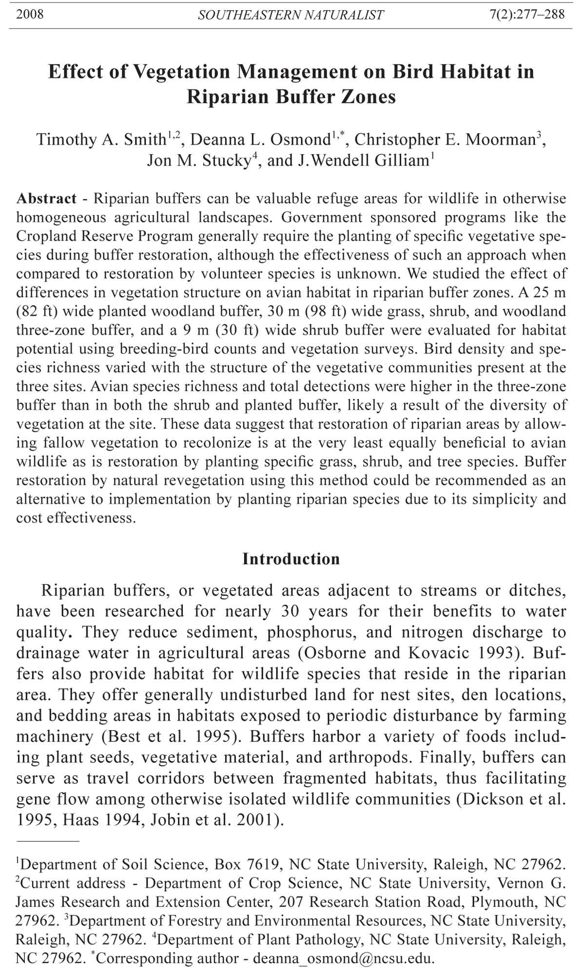
Of all three buffers in 2002, the three-zone buffer had the highest detections
of grassland (3.2), shrub/scrub (37.4), and woodland (43.8) species/
census day/1000-m buffer length, as well as the highest species richness (29
species) (Table 3, Fig. 1). Similar results were obtained during 2003 (Fig. 1).
Shrub species dominated the detections in the shrub buffer, while the planted
buffer contained primarily woodland birds.
Cardinalis cardinalis (Northern Cardinal) and Passerina cyanea (Indigo
Bunting) were the only two species recorded in all three buffers (Table 3).
Table 2. Woody vegetation with dbh >5 cm at the three-zone and planted buffers in the Coastal
Plain of North Carolina.
Three-zone buffer Planted buffer
Mean Relative Mean Relative
Species height (m) density height (m) density
American holly (Ilex opaca Ait.) - - 6 1%
Bald cypress (Taxodium distichum L.) - - 7 70%
Green ash (Fraxinus pennsylvanica Marsh.) - - 9 12%
Loblolly pine (Pinus taeda L.) 13 7% - -
Red maple (Acer rubrum L.) 8 15% 8 12%
River birch (Betula nigra L.) 9 34% - -
Sweetgum (Liquidambar stracifula L.) 12 33% - -
Swamp chestnut oak (Quercus michauxii Nutt.) 10 2% - -
Water oak (Quercus nigra L.) 12 4% - -
Yellow poplar (Liriodendron tulipifera L.) 11 4% 8 2%
Sweet bay (Persea palustris Raf.) - - 5 1%
2008 T.A. Smith, D.L. Osmond, C.E. Moorman, J.M. Stucky, and J.W. Gilliam 283
Indigo Bunting was the most frequently detected species in the three-zone
buffer, while Northern Cardinal and Agelaius phoeniceus (Red-winged
Blackbird) were the most frequently detected species in the planted buffer
and shrub buffer, respectively.
Table 3. Bird detections/census day/1000 m buffer length at three buffers in North Carolina
(2002–2003). 3Z = three-zone, Pl = planted, and Sh = shrub.
Site (detections/
census day/1000 m buffer length)
2002 2003
3Z Pl Sh 3Z Pl Sh
Grassland species (total) 3.2 1.4 2.0 0.0 0.0 1.6
Eastern Kingbird (Tyrannus tyrannus L.) 1.4 0.0 1.6 0.0 0.0 0.0
Eastern Bluebird (Sialia sialis L.) 1.4 1.4 0.0 0.0 0.0 0.0
Eastern Meadowlark (Sturnella magna L.) 0.5 0.0 0.4 0.0 0.0 0.8
Grasshopper Sparrow (Ammodramus 0.0 0.0 0.0 0.0 0.0 0.8
savannarum Gmelin)
Shrub/Scrub species (total) 37.4 1.4 22.2 35.1 2.7 21.4
Blue Grosbeak (Guiraca caerulea L.) 8.7 0.0 3.7 4.1 0.0 2.5
Brown Thrasher (Taxostoma rufum L.) 0.0 0.0 0.4 0.0 0.7 1.2
Common Yellowthroat (Geothlypis trichas L.) 4.6 0.0 4.9 5.5 0.0 4.5
Field Sparrow (Spizella pusilla L.) 5.9 0.0 1.2 5.9 0.0 2.9
Gray Catbird (Dumetella carolinensis L.) 0.0 0.0 0.0 1.4 0.0 0.0
Indigo Bunting (Passerina cyanea L.) 13.2 1.4 2.1 11.4 2.0 2.5
Northern Mockingbird (Mimus poloygottos L.) 0.0 0.0 1.2 0.0 0.0 0.4
Northern Bobwhite (Colinus virginianus L.) 0.5 0.0 0.8 0.5 0.0 1.2
Red-winged Blackbird (Agelaius phoeniceus L.) 0.0 0.0 7.4 0.0 0.0 6.2
Rufous-sided Towhee (Pipilo erythrophthalmus L.) 0.5 0.0 0.4 0.0 0.0 0.0
Yellow-breasted Chat (Icteria virens L.) 4.1 0.0 0.0 6.4 0.0 0.0
Woodland species (total) 43.8 26.0 2.1 29.2 19.1 2.5
American Crow (Corvus brachyrhyncos Brehm) 0.0 1.4 0.0 0.0 0.0 0.0
Blue-gray Gnatcatcher (Polioptila caerulea L.) 2.7 0.7 0.0 5.0 0.0 0.0
Blue Jay (Cyanocitta cristata L.) 1.8 0.7 0.0 0.5 0.0 0.0
Brown-headed Cowbird (Molothrus ater Boddaert) 0.5 0.0 0.0 0.5 0.0 0.0
Carolina Chickadee (Poecile carolinensis Audubon) 3.7 1.4 0.0 1.4 1.4 0.0
Carolina Wren (Thryothorus ludovicianus Latham) 4.1 5.5 0.0 4.1 4.1 0.0
Chipping Sparrow (Spizella passerina Bechstein) 0.9 0.0 0.0 0.0 0.0 0.0
Common Grackle (Quiscalus quiscula L.) 4.1 0.0 0.4 0.0 3.4 0.0
Downy Woodpecker (Picoides pubescens L.) 1.4 0.0 0.0 0.9 0.7 0.0
European Starling (Sturnus vulgaris L.) 9.1 0.0 0.0 1.8 0.0 0.0
Great-crested Flycatcher (Myiarchus crinitus L.) 1.4 1.4 0.0 0.9 0.7 0.0
Mourning Dove (Zenaida macroura L.) 0.9 0.7 0.0 3.2 0.7 0.0
Northern Cardinal (Cardinalis cardinalis L.) 4.1 9.6 1.6 3.2 6.8 2.5
Prothonatory Warbler (Protonotaria citrea Boddaert) 0.5 0.0 0.0 0.0 0.0 0.0
Red-bellied Woodpecker (Melanerpes carolinus L.) 2.7 1.4 0.0 1.4 0.0 0.0
Red-eyed Vireo (Vireo olivaceus L.) 0.5 0.0 0.0 0.5 0.0 0.0
Red-shouldered Hawk (Buteo lineatus Gmelin) 0.5 0.0 0.0 0.0 0.0 0.0
Tufted Titmouse (Baeolophus bicolor L.) 1.4 2.0 0.0 1.4 0.7 0.0
White-eyed Vireo (Vireo griseus Boddaert) 1.8 0.0 0.0 4.1 0.0 0.0
Yellow-billed Cuckoo (Coccyzus americanus L.) 1.8 1.4 0.0 0.5 0.7 0.0
Total Detections/census day/1000m 84.4 28.7 26.3 64.3 21.9 25.5
Species Richness 29.0 13.0 13.0 22.0 11.0 11.0
284 Southeastern Naturalist Vol.7, No. 2
Discussion
The structure of the plant community within each buffer site dictated the
composition of the avian community found there. For example, the majority
of the birds detected in the shrub buffer were shrub birds (Table 3). Furthermore,
the shrub buffer contained no woodland vegetation, which could
account for the low detections (2.1 to 2.5 detections/census day/1000-m
buffer length) of forest birds. Similarly, the planted buffer consisted primarily
of woodland vegetation and was primarily occupied by woodland birds
(Table 3). Few avian grassland or shrub species were detected.
Vegetation at the three-zone buffer contained relatively wide grass and
shrub areas, with a few trees present along the stream bank. This more
heterogeneous habitat seemed to support a greater variety of bird species.
Grassland birds such as Tyrannus tyrannus (Eastern Kingbird) and Sialia
sialis (Eastern Bluebird) were detected. Guiraca caerulea (Blue Grosbeak),
Indigo Bunting, Spizella arborea (Field Sparrow), and Geothlypis trichas
(Common Yellowthroat) were common shrub species observed. Polioptila
caerulea (Blue-gray Gnatcatcher), Poecile carolinensis (Carolina Chickadee),
and Thryothorus ludovicianus (Carolina Wren), which are all woodland
birds, also were frequently observed at this buffer.
There are several possible explanations for the wider range of detections
at the three-zone buffer. This buffer was 30 m wide on each side
of the drainage feature, resulting in a 60-m total width. The shrub and
planted buffers were present only on one side of the drainage feature
and were 9 m and 25 m wide, respectively. Dickson et al. (1995) studied
streamside zones of different widths in eastern Texas and concluded that
the abundance of some bird species, such as Carolina Wren, Baeolophus
bicolor (Tufted Titmouse), Coccyzus americanus (Yellow-billed Cuckoo),
Northern Cardinal, and Blue-gray Gnatcatcher, increased as the width of
habitat increased. Of these species in our study, all except Blue-gray Gnatcatcher
and Tufted titmouse in 2003 were more abundant in the planted
Figure 1. Detections
per census
day per 1000 m for
May–June 2002
and 2003 bird
sampling at three
riparian buffer
sites in the Coastal
Plain of North
Carolina.
2008 T.A. Smith, D.L. Osmond, C.E. Moorman, J.M. Stucky, and J.W. Gilliam 285
buffer than in the wider three-zone buffer. These species prefer woodland
habitats; however, the woodland portion of the three-zone buffer was much
narrower than the predominately woodland planted buffer. In this case, the
structure and composition of buffer vegetation seemed to influence the
bird community more heavily than did buffer width as the narrower woodland
buffer contained more woodland birds than did the wider three-zone
buffer. Additionally, Dickson et al. (1995) suggested that species such as
Yellow-breasted Chat, Blue-gray Gnatcatcher, Common Yellowthroat, and
Blue Grosbeak favored narrow streamside zones. In our study, detections
for these species were all highest in the three-zone buffer, which was the
widest of the three buffers investigated. These contradictions suggest that
the differences in species richness and relative abundance among the three
buffers could be due to some combination of habitat characteristics including
buffer width and vegetation type.
The surrounding landscape could have had an effect on the characteristics
of the avian community observed at the three sites. The three-zone
and planted buffers both connected larger adjacent woodland areas, while
the shrub buffer was somewhat isolated from significant woodland habitat.
More woodland birds may have occupied territories within the three-zone
and planted buffers because of their proximity to other suitable woodland
habitats. Although we did not control for variation in landscape context,
changes in relative amounts of forest and agriculture at large scales can infl uence
avian density and reproductive success (Riddle 2007).
Land management also differed among the three sites. The farmland
adjacent to the three-zone and shrub buffers was used for crop production
of corn, wheat, and soybeans, which most likely affected food availability
to birds within these buffered areas. The planted buffer was surrounded by
land farmed in pasture grass that was periodically cut for hay, but the crop
was sparse and likely contributed little in the form of bird forage during both
years of observation.
The differences in the bird community among the three buffer types
probably resulted from some combination of these aforementioned site
characteristics. The type of vegetation present at each site undoubtedly
played a major role in determining the bird community found within each.
Vegetation composition at the three-zone buffer incorporated characteristics
of three different habitat types (grassland, shrub, and woodland) into a
single streamside area. As a result, avian species ranging from grassland to
shrub and woodland birds occupied the area. Although the restoration simply
involved leaving the area fallow, management did have an effect on the
composition of the wildlife community. Spring mowing in the outer zone
once a year maintained habitat suitable for grassland birds such as Eastern
Bluebird and Sturnella. magna Linnaeus (Eastern Meadowlark). The 4- to
5-year early successional zone created by leaving the area undisturbed after
buffer widening created habitat suitable for shrub birds like Indigo Bunting
and Blue Grosbeak. The large trees along the stream bank, although sparse,
286 Southeastern Naturalist Vol.7, No. 2
were effective in supporting woodland species like Carolina Wren and Bluegray
Gnatcatcher.
Although most of the riparian vegetation at the three sites produced seeds
ranking from low to medium as Northern Bobwhite Quail food sources, the
birds were observed at the three-zone and shrub buffer sites. Bobwhite may
have chosen these zones for their cover protection and nesting habitat while
foraging for food outside the buffer. On the other hand, they may have found
suitable food within the buffer zone. Bobwhite forage for seeds during the
winter, but their high-protein diet during the warmer months predominately
consists of insects and other arthropods (Eubanks and Dimmick 1974) that
are commonly present in high densities within buffer zones (Whitaker et al.
2000). Although buffer seed production was less than ideal with respect to
quail forage, the vegetative structure at these two sites supplied essential
cover and indirect food sources for bobwhite residents. Bare ground was also
available for efficient foraging and movement throughout the buffer zones.
The inability of the buffer to produce highly desirable seed for Northern
Bobwhite did not prevent these birds from occupying the area.
This study suggests that restoration of riparian zones by allowing fallow
vegetation to recolonize is, at the very least, equally beneficial to avian
wildlife as is restoration by planting specific grass, shrub, and tree species.
Restoration by this method is more affordable and less labor intensive than
the alternative. Although governmental support is available to landowners
for buffer implementation, rarely does the payment cover the total expense
required for successful restoration using planted species. The less expensive
restoration by natural vegetation could entice more landowners to become
involved with programs like CRP and EQIP. Others may voluntarily create
buffer zones using this method due to its simplicity and effectiveness. To
skeptical landowners who are not comfortable undertaking rigorous implementation
techniques required by planting riparian vegetation, these simpler
and more affordable restoration practices could motivate them to establish
naturally revegetated buffers on their land.
Acknowledgments
This project was supported by the NRCS Watershed Science and Wildlife Habitat
Management Institute. The authors would like to thank Murphy-Brown LLC, Jim
Parrot, and Tom Padgett for allowing access to study sites and to Drs. Steven Broome
and Dan Israel for editing suggestions.
Literature Cited
Barbour, M.G., J.H. Burk, and W.D. Pitts. 1987. Terrestrial Plant Ecology, 2nd Edition.
Benjamin/Cummings Publishing Co., Inc. Menlo Park, CA.
Best, L.B. 1983. Bird use of fencerows: Implications of contemporary fencerow
management practices. Wildlife Society Bulletin 11:343–347.
Best, L.B., K.E. Freemark, J.J. Dinsmore, and M. Camp. 1995. A review and synthesis
of habitat use by breeding birds in agricultural landscapes of Iowa. American
Midland Naturalist 134:1–29.
2008 T.A. Smith, D.L. Osmond, C.E. Moorman, J.M. Stucky, and J.W. Gilliam 287
Best, L.B., T.M. Bergin, and K.E. Freemark. 2001. Infl uence of landscape composition
on bird use of rowcrop fields. Journal of Wildlife Management 65:
442–449.
Blake, J.G., and J.R. Karr. 1987. Breeding birds of isolated woodlots: Area and habitat
relationships. Ecology 68:1724–1734.
Brennan, L.A. 1991. How can we reverse the Northern Bobwhite population decline?
Wildlife Society Bulletin 19:544–555.
Bromley, P.T., W.E. Palmer, and S.D. Wellendorf. 2002. Effects of mesomammal reduction
and field borders on bobwhite and songbird abundance on farms in North
Carolina and Virginia. Final Report to NCWRC and VDGIF. 107 pp.
Buffington, J.M., J.C. Kilgo, R.A. Sargent, K.V. Miller, and B.R. Chapman. 1997.
Comparison of breeding bird communities in bottomland hardwood forests of
different successional stages. Wilson Bulletin 109:314–319.
Davidson, V.E. 1942. Bobwhite foods and conservation farming. Journal of Wildlife
Management 6:97–109.
Dickson, J.G., J.H. Williamson, R.N. Conner, and B. Ortego. 1995. Streamside zones
and breeding birds in eastern Texas. Wildlife Society Bulletin 23:750–755.
Droege, S., and J.R. Sauer. 1990. Northern Bobwhite, Gray Partridge, and Ringnecked
Pheasant population trends (1966–1988) from the North American
Breeding Bird Survey. Pp. 2–20, In Church, K.E., R.E. Warner, and S.J. Bradley
(Eds.). Perdix V: Gray partridge and ring-necked pheasant workshop.
Eubanks, T.R., and R.W. Dimmick. 1974. Dietary patterns of Bobwhite Quail on
Ames Plantation. University of Tennessee Agricultural Experiment Station Bulletin
534.
Fahrig, L. 1997. Relative effects of habitat loss and fragmentation on population
extinction. Journal of Wildlife Management 61:603–610.
Finch, D.M. 1989. Habitat use and habitat overlap of riparian birds in three elevational
zones. Ecology 70:866–880.
Haas, C.A. 1994. Dispersal and use of corridors by birds in wooded patches on an
agricultural landscape. Conservation Biology 9:845–854.
International Bird Census Committee. 1970. An international standard for a mapping
method in bird census work recommended by the International Bird Census
Committee. Audubon Field Notes 24:722–726.
Jobin, B., L. Choiniere, and L. Belanger. 2001. Bird use of three types of field margins
in relation to intensive agriculture in Quebec, Canada. Agriculture, Ecosystems,
and Environment 84:131–143.
Jones, J.D. and M.J. Chamberlain. 2004. Efficacy of herbicides and fire to improve
vegetative conditions for Northern Bobwhites in mature pine forests. Wildlife
Society Bulletin 34:1077–1084.
Landers, J.L., and A.S. Johnson. 1976. Miscellaneous Publication Number 4: Bobwhite
quail food habits in the southeastern United States with a seed key to
important foods. Tall Timbers Research Station, Tallahassee, FL.
Marcus, J.F. 1998. The effects of predation and habitat improvement on farmland
birds. M.Sc. Thesis. North Carolina State University, Raleigh, NC.
Marcus, J.F., W.E. Palmer, and P.T. Bromley. 2000. The effects of farm field borders
on overwintering sparrow densities. Wilson Bulletin 112:517–523.
Moorman, C.E., and D.C. Guynn, Jr. 2001. Effects of group-selection opening size
on breeding bird habitat use in a bottomland forest. Ecological Applications 11:
1680–1691.
288 Southeastern Naturalist Vol.7, No. 2
Novak, J.M., P.G. Hunt, K.C. Stone, D.W. Watts, and M.H. Johnson. 2002. Riparian
zone impact on phosphorus movement to a Coastal Plain black water stream.
Journal of Soil and Water Conservation 57:127–133.
Osborne, L.L., and Kovacic, D.A. 1993. Riparian vegetated buffer strips in waterquality
restoration and stream management. Freshwater Biology 29:243–258.
Pucket, K.M., W.E. Palmer, P.T. Bromley, J.R. Anderson, Jr., and T.L. Sharpe. 1995.
Bobwhite nesting ecology and modern agriculture: a management experiment.
Proceedings of the Annual Conference of the Southeastern Association of Fish
and Wildlife Agencies 49:505–515.
Riddle, J.D. 2007. Maximizing the impact of field borders for quail and early-succession
songbirds: What’s the best design for implementation? Ph.D. Dissertation.
North Carolina State University. Raleigh, NC.
Stone, K.C., P.G. Hunt, S.W. Coffey, and T.A. Matheny. 1995. Water quality status of
a USDA water quality demonstration project in the eastern Coastal Plain. Journal
of Soil and Water Conservation. 50:567–571.
Triquet, A.M., G.A. McPeek, and W.C. McComb. 1990. Songbird diversity in
clearcuts with and without a riparian buffer strip. Journal of Soil and Water
Conservation 45:500–503.
United States Department of Agriculture-Natural Resources Conservation Service
(USDA-NRCS). 1999. The National Conservation Buffer Initiative: A Qualitative
Evaluation. Applied Research Systems. Madison, WI.
USDA-NRCS. 2004. Farm Service Agency Notice CRP-479. Farm Service Agency,
Washington DC.
USDA-NRCS. 2005. The plants database, Version 3.5 (http://plants.usda.gov). Data
compiled from various sources by Mark W. Skinner. National Plant Data Center,
Baton Rouge, LA 70874-4490 USA.
USDA-NRCS. 2006. Conservation Programs Manual, Policy 440, Part 517. Farm
Service Agency. Washington, DC.
Whitaker, D.M., A.L. Carrol, and W.A. Montevecchi. 2000. Elevated numbers of
fl ying insects and insectivorous birds in riparian buffer strips. Canadian Journal
of Zoology 78:740–747.


 The Southeastern Naturalist is a peer-reviewed journal that covers all aspects of natural history within the southeastern United States. We welcome research articles, summary review papers, and observational notes.