2009 SOUTHEASTERN NATURALIST 8(2):213–226
Thinking Big: A Conservation Vision for the Southeastern
Coastal Plain of North America
Paul A. Keddy*
Abstract - Maps of wild or roadless areas in North America show that most lie west of
the Mississippi River. The Everglades is one exception. Yet there are others. Using existing
data, I draw attention to four large areas in the southeast that are worthy of national
as well as regional attention. These four (Eglin: 187,000+ ha; Apalachicola: 228,000+
ha; Okefenokee-Oceola: 289,000+ ha; De Soto: 200,000+ ha) have nearby lands that
offer the potential to expand the total protected territory for each area to well beyond
500,000 ha. From the North American perspective, these areas are essential elements of
a national conservation plan. These areas urgently need (1) land acquisition to link with
nearby protected lands and establish ecologically meaningful boundaries, (2) restoration
of natural forces (particularly fl ooding and fire), and (3) forestry practices focused
upon restoration.
Introduction
Over the past decade, inspiring conservation visions have been presented
for wild lands in the American west, as well as for the deciduous forests of
the northeast (e.g., Quinby et al. 2000, Sayen 1995/1996). These conservation
visions were assisted by the presence of large tracts of publicly owned
land. Even the extensively urbanized eastern landscapes have at least two
wild areas—the Adirondacks to the north and Great Smoky Mountains
National Park to the south. When I travel and lecture, I am struck by how
many students have heard of Yellowstone, the Great Smoky Mountains, and
the Everglades, but when I mention the coastal plain of the southeast and
its remarkable diversity, I usually receive puzzled looks. Even when I speak
within the region, it regularly appears that local residents do not appreciate
the national significance of their landscape, nor do they have an awareness
of our priority conservation areas.
The coastal plain of the southeast has expansive areas covered in fire-dominated
pine forests, once interrupted only by rivers meandering through equally
vast acreages of swamp. Once a land of Alligator mississippiensis Daudin
(American Alligator) and Gopherus polyphemus Daudin (Gopher Tortoise),
wild orchids and carnivorous plants, Campephilus principalis L. (Ivory-billed
Woodpecker) and Conuropsis carolinensis L. (Carolina Parakeet), and panthers
and wolves, it has been settled by European humans for hundreds of years
(Silver 1990). We need to present the nation with a conservation vision for the
southeast region of North America equivalent in scope to Yellowstone to Yukon
for the Northwest, or Adirondacks to Algonquin for the Northeast. This is not to
say that local groups do not have a plan (indeed, as I shall mention, both the
*Department of Biological Sciences, Southeastern Louisiana University, Hammond,
LA 70402; drpaulkeddy@gmail.com.
214 Southeastern Naturalist Vol. 8, No. 2
Environmental Protection Agency [EPA] and The Nature Conservancy [TNC]
do), but my impression is that outside of these dedicated working groups, few
North Americans apparently know of or appreciate the significance of this
work. The core areas have limited profile, except among specialists. Even the
most superficial inspection of public maps showing roadless areas (The Wildlands
Project 1993), wilderness areas, or national parks, illustrates how the
southeastern coastal plain has been significantly under-represented in national
conservation planning. It might not matter if the coastal plain were an area of
low conservation importance. It is, however, an area with some of the highest
biological diversity in North America and many endemic species (Estill and
Cruzan 2001, Stein et al. 2000, White et al. 1998). Freshwater fish, wading
birds, and carnivorous plants are but three examples of fauna and fl ora that here
attain their highest levels of species diversity on the continent.
Simultaneously, the southeastern coastal plain has had a long history of
exploitation through logging, agriculture, the naval stores industry, plume
hunting, and levee construction (Silver 1990, White et al. 1998, Williams
1989). The dominant ecosystem type, Pinus palustris P. Mill. (Longleaf Pine)
savannas, has been reduced to mere fragments comprising well under 5 percent
of its original extent (Christensen 1988, Folkerts 1982, Herman 1993, Platt
1999). Fire is no longer a natural force in the landscape. The southeast was also
the home of now extinct species including Ectopistes migratorius L. (Passenger
Pigeon) and the Carolina Parakeet. The Ivory-billed Woodpecker, thought
to be extinct (Sibley et al. 2006), is believed by some to have recently been discovered
in Arkansas (Fitzpatrick et al. 2005). Canis rufus Audubon & Bachman
(Red Wolf) and Puma concolor coryi Bangs (Florida Panther) are on the verge
of extinction. Invasive species including Triadica sebifera (L.) Small (Tallowtree),
Ligustrum japonicum Thunb. (Japanese Privet), Imperata cylindrica
(L.) Beauv. (Cogon Grass), and Pueraria montana (Lour.) Merr. (Kudzu) are
causing significant changes in composition and function.
There is no single name for this vast area, which I have referred to as
the southeast and the coastal plain. Such inconsistent terminology probably
reduces its profile and complicates conservation planning (compare this to
the immediate name recognition of the Great Smoky Mountains or the Everglades).
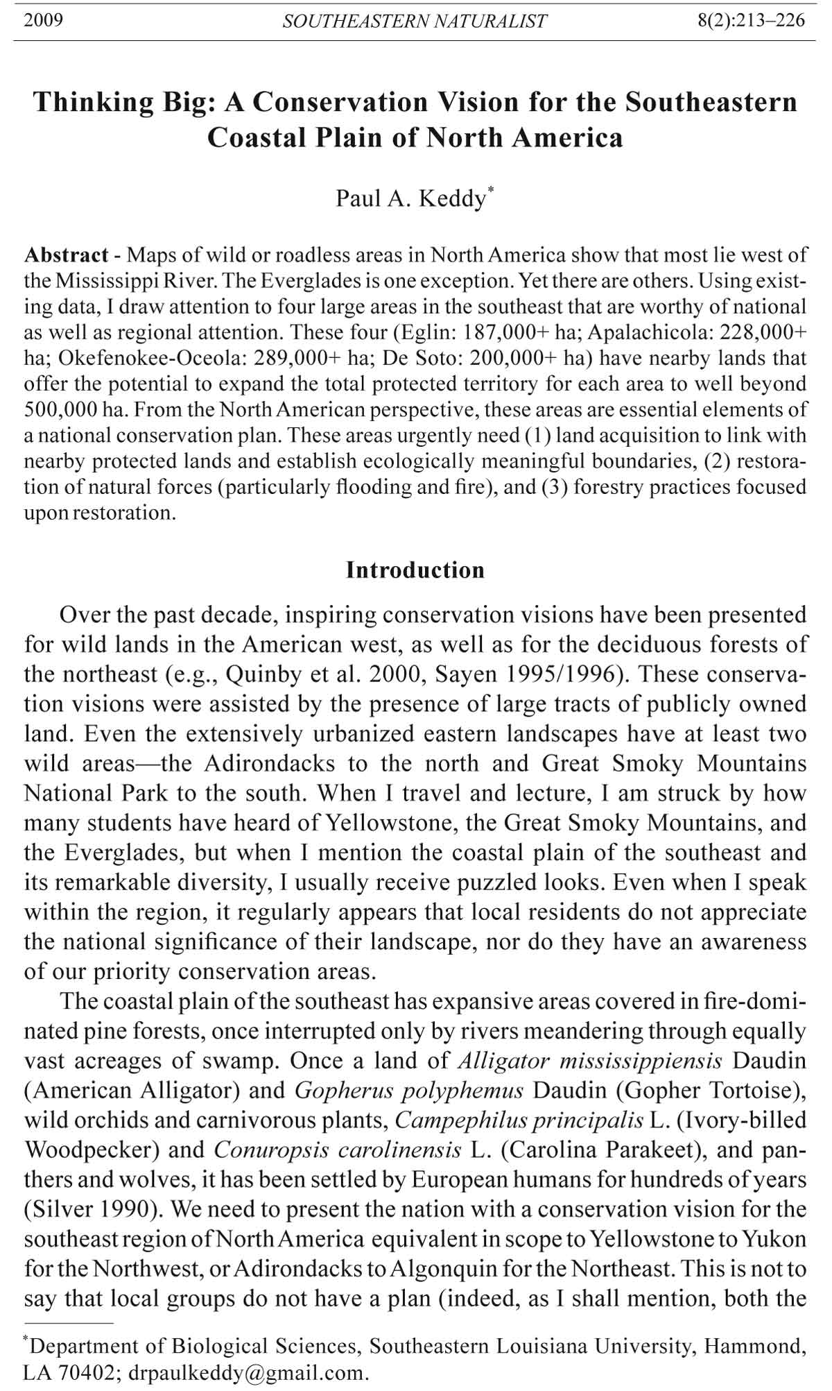
From the perspective of physiography, it is the East Gulf Coastal
Plain and, further east, the Sea Island section of the Coastal Plain (Fig. 1).
According to World Wildlife Fund’s ecoregion classification (WWF 2001), it
is part of the Southeastern Conifer Forest. Based on the ecoregion map used
by The Nature Conservancy (Sotomayor 2004), it is part of the East Gulf
Coastal Plain and the South Atlantic Coastal Plain.
It is not clear why the southeastern coastal plain has languished from
the perspective of national concern. It may be the lack of one recognizable
name, or the apparent lack of a pre-existing protected land base, or the lack
of a major national park. Perhaps we are distracted by the Great Smoky
Mountains to the north, and the Everglades to the south, and think that there
is little in between. Perhaps the population density of conservationists in
2008 P.A. Keddy 215
the southeast is lower than elsewhere. Even Foreman’s (1993) otherwise
visionary proposal for Wilderness Recovery Complexes East of the Rockies
has the same weakness—it mentions a mere seven sites— five in the north,
plus the Great Smoky Mountains and the Everglades, while The Big Outside
(Foreman and Wolke 1992) has similar limitations.
Have we already reached the point where all hope of wild areas in the
southeast has vanished? This article is to remind us otherwise, and to draw
attention to the existence of large, comparatively wild core areas, as well as
potential components of inter-core corridors. Both are essential elements of a
wild land recovery vision (Carr et al. 2002, Noss 1993). This vision summarizes
the strategic goal and suggests a public, educational, and scientific focus for
coordinated effort in land-use planning and conservation across the southeast.
Wild Areas and Core Selection Criteria
I use the term “wild area” rather than the more divisive word “wilderness”
to describe the areas selected for discussion. The southeast has been developed
for so long, and with such intensity, that there are no large areas that have not
in some way been impacted by humans. Most southern ecosystems require
fire, and fire regimes have been altered for decades if not centuries. The largest
remaining swamps, including the Atchafalaya in the west and the Okefenokee
and Great Dismal swamps in the east, are scarred by canals and drainage ditches.
Since the legal definition of wilderness is exquisitely narrow, I do not want
to ignore areas that have great potential for restoration as wild places merely
Figure 1. The Atlantic coastal plain, from Louisiana to South Carolina (excluding the
Florida peninsula) is divided into two physiographic regions (3b - East Gulf Coastal
Plain, 3d - Sea Island section), three ecoregions by World Wildlife Fund (NA0413 -
Southeastern Mixed Forest, NA0529 - Southeastern Conifer Forest, NA0517 - Middle
Atlantic Coastal Forest), and two ecoregions by The Nature Conservancy (53 - East Gulf
Coastal Plain, 56 -South Atlantic Coastal Plain). This paper focuses on the shaded area.
216 Southeastern Naturalist Vol. 8, No. 2
because they do not now qualify as legal wilderness. Our focus is the big picture,
as emphasized by Michael Soulé (1993:7):
“Repair—restoring and reconnecting the land—will take time … Road building
in major sections of National Forests and BLM lands will have to cease,
and many existing logging roads will have to be closed. In the lowlands, some
eroding and degraded croplands … will have to be converted to other uses. It
is no simple matter to repair the ravages of centuries. … The key is thinking
BIG in both space and time.”
The area of interest is somewhat arbitrarily established as the Southeastern
Conifer Forest Ecoregion from Mississippi to South Carolina, and south
to include the Florida Panhandle. This region (Fig. 1) fits rather well with
physiographical and biological reality. It also meshes with an earlier effort
that addressed the more northern section of the coastal plain (Keddy and
Wisheu 1994), which extends into central Nova Scotia, where the Tobeatic
Biosphere Reserve now has a core area of some 141,750 ha.
I examined existing data sources to identify (1) large wild areas of about
200,000 ha in some form of protected status, and (2) adjoining or satellite
lands giving the potential for increasing the total area to 500,000 ha. (ca.
1 million ac.). Areas of this size would be large enough to allow natural
lightning-caused fires to burn with minimal human intervention, and large
enough to support indigenous large carnivores including the Florida Panther
and Red Wolf, as well as the omnivorous Ursus americanus Pallas (Black
Bear). I began with an important, but frequently overlooked, map of forested
lands in the southeast (Fig. 2). I also consulted the short list of the largest
wild areas on World Wildlife Fund’s web site for the Southeastern Conifer
Forest Ecoregion (WWF 2001). I also drew upon the EPA Southeastern US
Ecological Framework Project (Carr et al. 2002) and the East Gulf Coastal
Plain Ecoregional Plan (The Nature Conservancy 2001). These and other
documents were further consulted to identify some of the smaller conservation
lands mentioned as potential corridor components.
Although habitat type, in addition to size, is often used in natural area
evaluation, it was not used as a criterion for core-area identification because
the main objective was to see the big picture—to find big wild areas. Whether
a wild area contains cypress swamps or Longleaf Pine forest, for example,
is less important— both southern forested wetlands and Longleaf Pine forests
are among the endangered ecosystems of the United States (White at al.
1998). Further, most sources described habitat mixes of protected areas, but
often without figures for acreage of specific habitat types.
The Conservation Vision
Priority areas for ecosystem conservation
Four core areas of relatively wild land occur in the southeastern coastal
plain region (Fig. 3). Each core contains a central large area with some degree
of protection, along with adjoining or satellite protected areas. Each
has the capacity to protect many examples of endangered coastal plain
ecosystems, including Longleaf Pine forests, swamps, and mixed deciduous
forests. These areas have the long-term potential not only to support species
2008 P.A. Keddy 217
endemic to the region, but also to include large carnivores that need large
continuous blocks of land, such as wolves and panthers.
Eglin Air Force Base (187,694 ha; Fig. 3) is one of the area’s largest blocks
of federal land. Indeed, it was, called Choctawhatchee National Forest before it
was converted to military use in 1940. Just north of Eglin is Blackwater River
State Forest (76,786 ha), and adjoining that forest to the north (in Alabama) is
Conecuh National Forest (33,935 ha). The Yellow River Ravines, a 6744-ha
parcel proposed for acquisition by the State would directly link the air force
base and state forest (FDEP 2005). To the east, the base is linked to the 23,206-
ha Choctawhatchee River Water Management Area by Nokuse Plantation
(Florida Wildlife Federation, undated). A conservation easement has been approved
by the State for about 45% of this 21,465-ha private conservation area
(FDEP 2005). Together these areas comprise some 343,100 ha.
Apalachicola National Forest (Fig. 3) is also one of the largest consolidated
blocks (228,420 ha) of public land east of the Rocky Mountains
according to Kane and Keeton (1993). Satellite sites include Tate’s Hell State
Forest (74,925 ha), Apalachicola River Wildlife and Environmental Area
(33,434 ha), Tates Hell/Carrabelle Tract (5374 ha acquired; FDEP 2004), St.
Marks National Wildlife Refuge (27,540 ha), and Aucilla Wildlife Management
Area (43, 095 ha). Together these sites comprise about 412,800 ha.
Figure 2. Significant areas of forest still exist along the coastal plain. Percent forest
cover was determined for each county in the region (from Boyce and Martin 1993).
218 Southeastern Naturalist Vol. 8, No. 2
Okefenokee-Oceola (Fig. 3) is the third core area. Okefenokee National
Wildlife Refuge, largely in Georgia, protects 160,380 ha of swamp of which
more than 141,750 are designated a National Wilderness Area. Osceola National
Forest, just south of the Okefenokee, adds some 81,000 ha of swamp
and fl atwoods. These two areas have been joined by 47,603 ha of the Pinhook
Swamp purchased by the State of Florida (FDEP 2005). This core area
is currently about 289,000 ha.
De Soto National Forest, the most western of the core areas (Fig. 3), is
probably the least well known of the four, and also the most fragmented. It
comprises more than 202,500 ha, although some 54,675 ha of this have been
allocated to the military as Camp Shelby. De Soto lacks ecologically meaningful
boundaries; there are two units separated by 25 km, the southern one being
deeply constricted into almost two separate areas. As well, many in-holdings
remain in private hands. Satellite areas that one day might be linked to De Soto
include: in the west, the 15,188-ha Bogue Chitto National Wildlife Refuge
along the Pearl River; in the north, the 61,050-ha Chickasawhay Wildlife
Management Area; and in the south, the 7695-ha Mississippi Sandhill Crane
National Wildlife Refuge. Together these areas total roughly 286,400 ha. The
gaps between the national forest and these satellite areas are significant. A
partnership to conserve the lower Pearl River (easternmost Louisiana/Mississippi
boundary) may be useful in catalizing a linkage with Bogue Chitto (The
Figure 3. Four core areas (each with about 200,000 ha in public ownership) where
it may be possible to assemble wild areas of more than 500,000 ha. The map also
shows the geographical distribution of Longleaf Pine (gray shaded area), one of the
characteristic tree species of the coastal plain.
2008 P.A. Keddy 219
Nature Conservancy 2005b). The forested area map (Fig. 2) shows potential
for core extension northeast into Alabama as well.
These four core areas are part of several regional conservation initiatives
that aim to protect biodiversity of the southeastern coastal plain. For example,
the Eglin Air Force Base and Apalachicola National Forest are both considered
significant core areas in Florida (Cox et al. 1994, Florida Greenways
Commission 1994; although in the latter report, they are called hubs rather
than cores). They are also the endpoints of the Northwest Florida Greenway
planning corridor—a conservation corridor/military base buffer being created
jointly by numerous organizations (FDEP 2004). The hub/core maps fail to
emphasize, however, that these are national—indeed continental—priorities
rather than just state core areas. Adjoining natural areas across the northern
border of Florida that cross state boundaries are rarely shown, seriously misrepresenting
the true size of these blocks of wild lands. An Environmental
Protection Agency study (Carr et al. 2002) indicated that both the Eglin and
Apalachicola cores were significant natural areas, but their map included a
vast region, conveying the impression that the four core areas were dwarfed
by the Everglades. Figure 4 reproduces one east–west slice out of the Carr et
al. (2002) map of priority and significant ecological areas. The Nature Conservancy,
appropriately, regards the Apalachicola River and Bay as one of their
priorities for North America (The Nature Conservancy 2003).
In my experience, the Okefenokee-Osceola area is under-appreciated,
perhaps because it straddles a state border, perhaps because the Okefenokee
is largely swamp while the Osceola is largely Longleaf Pine forest, or perhaps
Figure 4. Priority ecological areas and significant ecological areas were mapped by a
group working for the EPA (Carr et al. 2002). This figure is an east–west slice from
their larger map to focus on eastern coastal plain habitats (and also to avoid distraction
by the Great Smoky Mountains and the Everglades).
220 Southeastern Naturalist Vol. 8, No. 2
because of the cumbersome name. A single state, or single habitat perspective
would equally fail to convey adequately the enormous core area for wild land
recovery that can be perceived when political and ecological boundaries are set
aside. The future for this area seems promising, since over 60% of the Pinhook
Swamp, which directly links these large areas, has been acquired by the State of
Florida, and the remainder is recommended for purchase (FDEP 2005).
De Soto National Forest and the surrounding landscape merits much higher
significance than it is normally accorded. The southern parts of De Soto,
being fl atter and wetter, and containing extensive wet savannas, may have the
greatest ecological significance. Its regional significance is often overlooked.
Large-scale maps of the southeast naturally tend to emphasize the Okefenokee
and the Everglades. State maps fail to place De Soto in its appropriate national
ecological context—that of coastal plain ecosystems in general and Longleaf
Pine savannas in particular. Whichever way you map it, De Soto’s significance
is minimized. The US Forest Service website for De Soto (www.fs.fed.us/r8/
mississippi/desoto) illustrates how little the public is told about the potential
of this core area.
Opportunities for core-area linkage
Core areas will eventually need to be linked, and there are many opportunities
for connecting these areas (e.g., Carr et al. 2002, The Nature Conservancy
2001). In many respects, these details have to be left to regional agencies with
local experience. The good news is that there has been a steady acquisition of
lands for this purpose. Again, however, I am left with the clear impression that
land acquisitions in the Rocky Mountains often publicize the national perspective
of interconnected cores and corridors (e.g., Yellowstone to Yukon), while
our acquisitions in the southeast are not clearly identified as fitting into a large
regional restoration strategy. Some details of ongoing opportunities follow. Of
course, the details change rapidly as the network grows.
The Apalachicola River (along with the Flint and Chattahoochee rivers)
has been linked to the Appalachian Mountains since the early Cenozoic, and
has a rich mixture of temperate forest species, as well as endemic plants such
as Torreya taxifolia Arn. (Florida Nutmeg) and Taxus fl oridana Nutt. ex Chapman
(Florida Yew) (Platt and Schwartz 1990). The bluffs and rivers in this
area have some of the highest tree species densities found in the eastern United
States (Platt and Schwartz 1990). Currently, this habitat is protected in the
Apalachicola Bluffs and Ravines Preserve (The Nature Conservancy) and
Torreya State Park. Over 10,125 additional ha (St. Joe Timberland and Apalachicola
River candidates) scattered along a 60-km stretch of the Apalachicola
River from Chattahoochee to Orange, and 5483 ha along one of its tributaries
(Middle Chipola River) are recommended for acquisition by the state as conservation
land (FDEP 2005).
Between the Apalachicola core and the Eglin core (Fig. 3) lie several conservation
lands, proposed for purchase in the State’s Florida Forever Program
(FDEP 2005), that could serve as elements in an inter-core linkage. The largest
are Sand Mountain (13,916 ha, 48 km NW of Tates Hell State Forest), and a
large area around Lake Wimico (about 16,200 ha of St. Joe Timberland property),
located adjacent to Apalachicola River Wildlife and Environmental Area.
2008 P.A. Keddy 221
The Okeefenokee-Oceola core area is connected by the Pinhook Swamp
to a corridor of protected land (state parks, state forests, wildlife management
areas, water management district conservation lands) that stretches
along the Suwannee River (Suwannee River Water Management District
undated). The majority of the coastline from Lower National Wildlife Refuge
(21,439 ha), at the mouth of the Suwannee, north through Big Bend
Wildlife Management Area (27,990 ha) to St. Marks National Wildlife Refuge
(near Apalachicola National Forest), and from the Suwannee south to
Chassahowitzka National Wildlife Refuge (over 12,555 ha), has been designated
conservation land (FFWCC 2001, 2004). This corridor is the longest
stretch of undeveloped coastline in the continental US. (R. Noss, University
of Central Florida, Orlando, pers. comm.). There are also plans to connect
the Oceola area, via the Camp Blanding-Oceola Greenway (61,965 ha), to
Raiford Wildlife Management Area and Camp Blanding Military Reservation
located about 40 km to the southeast (FDEP 2004).
The Eglin and De Soto core areas are separated by 160 km— the same
distance between the Apalachicola and Okefenokee-Oceola areas, but almost
one and a half times the distance between the Eglin and Apalachicola
areas. In addition to distance, creating linkages between De Soto and Eglin
is most challenging because it necessitates crossing two different state
boundaries. Several parcels of land along the Perdido River (the western
boundary of Florida with Alabama) totaling 3159 ha have been recommended
for acquisition by the State of Florida (FDEP 2005). In the southwestern
third of Alabama, there are numerous conservation lands that could play a
role in this linkage. Eleven tracts of land under the Forever Wild Program,
ranging from 7.7 to 14,497 ha, have been acquired by the state for a total of
18,396 ha (ADCNR 2004a). An additional 51,156 ha have been designated
as wildlife management area (ADCNR 2004b). In the Mississippi portion of
the gap between De Soto and Eglin, 1985 ha of nature preserve (The Nature
Conservancy 2005a), and 20,395 ha of wildlife management area (MDWFP
2004) could also contribute to the linkage.
Putting it back together
While one cannot deny the national significance of the Everglades
and the Great Smoky Mountains, it is my consistent impression that
conservationists continue to overlook the national importance of intervening
areas such as the East Gulf Coastal Plain. This oversight has negative
consequences for public awareness, and eventually for funding. The areas
highlighted in this article would be core areas in national conservation plans
with the long-term objective of re-wilding (sensu Foreman 2004) areas of
the coastal plain. Acquisition of land in the vicinity of all four core areas
is needed to (1) link the central core area with nearby satellite lands and
(2) establish ecologically meaningful boundaries. Land acquisition is the
first priority because fragmented habitats are inherently difficult to manage,
particularly when fire and flooding are the key landscape regulating processes,
and when large predators roam across large areas.
222 Southeastern Naturalist Vol. 8, No. 2
Once appropriate ecological boundaries are established, the natural
processes that create the characteristic composition and pattern of our southeastern
landscape could be increasingly allowed to operate. These processes
would include natural fire regimes, particularly frequent burns ignited by
lightning (Platt 1999, Shlisky et al. 2007, Sutter and Kral 1994) and natural
hydrological pulses such as spring fl oods (Keddy 2000, Middleton 2002, Sutter
and Kral 1994). Large native carnivores including the Florida Panther and
Red Wolf could be reintroduced. This would restore food webs, and possibly
protect plant communities from over-grazing by herbivores (Alverson et al.
1988, McGraw and Furedi 2005). As contiguity increased, it would also be
desirable to remove roads and other human artifacts from these core landscapes.
Roads create many problems for wild species and wild areas (Forman
et al. 2003). For example, roads create firebreaks and restrict fire management
owing to potential lawsuits from motorists who might be injured in accidents
related to smoke. Given the rapid pace of development in the south, building
continuous core land units must be a top priority. Logging can be carefully
controlled, with the focus upon forestry techniques that restore natural communities,
and slowly phased out where inappropriate. Careful logging of
Pinus taeda L. (Loblolly Pine), Pinus elliottii Engelm. (Slash Pine) or Pinus
clausa (Chapman ex Engelm.) Vasey ex Sarg. (Sand Pine) (depending upon
the coastal plain region) followed by burning may actually benefit many areas,
and begin the process of conversion back to Longleaf Pine.
The need to establish ecologically meaningful boundaries is most obvious
in the case of De Soto, where the existing area of national forest is
deeply divided and large private in-holdings are at risk of development. The
region is also at greatest risk from development spilling northward from the
casino culture of Biloxi and Gulfport. Consider Rana sevosa Goin and Netting
(Dusky Gopher Frog). It once extended from the Mississippi River to
the Mobile River. Last seen in Alabama in 1922 and last seen in Louisiana
in 1967, a mere 100 individuals now survive—in one pond on the southern
edge of De Soto. Here, a residential development, golf course, new and
expanded highways, and a proposed reservoir all threaten these last few
individuals (USFWS undated).
To complete the conservation vision, we must eventually link the core areas
to each other, and to other large wild areas. I have already mentioned that there
are numerous smaller protected areas being acquired as potential stepping
stones to create corridors of ecologically functional conservation land. River
valleys also provide an opportunity. This is ironic, even counter-intuitive, since
rivers have often been major ecological barriers to species on the coastal plain
as illustrated by the patterns of endemism (Estill and Cruzan 2001). Being the
biggest river by far, the Mississippi has been the most pervasive barrier, and different,
but related, species often occur on each side. River corridors (and their
multiple branches and tributaries) would also have been significant barriers to
fire. Yet river corridors may now provide a tool for rebuilding some linkages.
To start, land acquisition along rivers and swamps often incidentally includes
adjoining uplands, which, rather than being unwanted acreage, may contain
significant ecosystems in their own right. Watercourses provide natural eco2008
P.A. Keddy 223
logical boundaries for uplands, and likely enhance opportunities for wild and
prescribed fires. Finally, although they may not offer direct routes for linkage,
networks of river corridors are already widespread in the region. With growing
evidence that global warming is likely to change sea levels (Bindoff et al. 2007,
Rahmstorf et al. 2007) and local climates (Meehl et al. 2007), particular emphasis
should likely be placed upon north–south corridors to allow species to
migrate inland and northward. Conveniently, major river valleys like the Apalachicola
River could play a role here, just as they may have done in the past.
Certainly there are many additional areas important for conserving biodiversity
in the southeastern coastal plain, as is recognized by The Nature
Conservancy’s ecoregional plans. Some are small fragments of unusual ecosystems
with endemic species having very local distributions well outside
the four large blocks described here. Other important large blocks of land
in the southeast lie outside the Southeastern Conifer Forest Ecoregion. Two
notable examples west of the Mississippi, but still on the coastal plain, exceed
200,000 ha. The Big Thicket/Sabine/Kisatchie area on the Texas/Louisiana border
is dominated by fire-controlled conifer forests and the Atchfalaya Swamp,
consisting of fl ood-controlled cypress swamp and bottomland hardwoods, is
possibly the largest swamp in the nation and part of the Mississippi River fl oodplain.
On the eastern (Atlantic) extreme of the coastal plain, the Great Dismal
Swamp/Pocosin area occurs on the boundary of Virginia and North Carolina.
The nearby Alligator River National Wildlife Refuge protects more than 60,750
ha, and the Great Dismal Swamp National Wildlife Refuge protects another
40,500. Protected lands in this latter wetland area are badly fragmented, and
building a core area will require much more effort. Even so, Red Wolves have
been successfully reintroduced to the Alligator River National Wildlife Refuge.
In conclusion, protecting coastal plain land with ecologically reasonable
boundaries is essential. As larger blocks of land are acquired, natural processes
can increasingly be restored. I suggest that we have to do a better job of emphasizing
the national significance of the coastal plain region recognized here
(Fig. 1) to audiences both within and outside the region. Without a regional and
national constituency, the area will receive a lower priority than it deserves.
We may have to consider coming up with new names for some of these areas—
somehow it is hard to make the case to an audience that Yellowstone National
Park and Eglin Air Force Base might have equal biological significance. There
is so much more than an air base, but who would guess? We could also place
greater emphasis in our teaching, writing, and research upon the important core
areas that comprise a national conservation plan for the region. We could find a
way to publicize the regional conservation plans already in existence (such as
the EPA and TNC plans), in a way that does not compromise future land acquisition—
we might begin, as I have done here, by at least naming our four core
areas on a single regional map. Perhaps a future special issue of Southeastern
Naturalist could focus upon the major features of the core areas for educational
and research purposes. We could think more about how to re-establish natural
fire and fl ooding regimes in these areas. Finally, with forecast changes in human
population distribution, climate, and sea level, we will also need to build a
system that is resilient in the face of future pressures.
224 Southeastern Naturalist Vol. 8, No. 2
Acknowledgments
I thank the many field ecologists and agencies who collected and compiled the
information which I was able to draw upon for this discussion paper. I also appreciate
the tutoring provided by field ecologists from Louisiana to Florida who have generously
shared their knowledge of the landscape with me. I also thank Cathy Keddy for
her help with the web searches and editing.
Literature Cited
Alabama Department of Conservation and Natural Resources (ADCNR). 2004a. Forever
Wild Program tracts. Available online at http://www.outdooralabama.com/
watchable-wildlife/where/forever-wild.cfm. Accessed November 30, 2005.
ADCNR. 2004b. Alabama public hunting areas. Available online at http://www.outdooralabama.
com/hunting/land/wildlife-areas. Accessed November 30, 2005.
Alverson W.S., D.M. Waller and S.J. Solheim. 1988. Forests to deer: Edge effects in
Northern Wisconsin. Conservation Biology 2:348–358.
Bindoff, N.L., J. Willebrand, V. Artale, A, Cazenave, J. Gregory, S. Gulev, K. Hanawa,
C. Le Quéré, S. Levitus, Y. Nojiri, C.K. Shum, L.D. Talley, and A. Unnikrishnan.
2007. Observations: Oceanic climate change and sea level. Pp. 385–432, In S.
Solomon, D. Qin, M. Manning, Z. Chen, M. Marquis, K.B. Averyt, M. Tignor, and
H.L. Miller (Eds.). Climate Change 2007: The Physical Science Basis. Contribution
of Working Group I to the Fourth Assessment Report of the Intergovernmental
Panel on Climate Change. Cambridge University Press, Cambridge, UK and New
York, NY.
Boyce, S.G., and W.M. Martin. 1993. The future of the terrestrial communities of the
southeastern United States. Pp. 339–366, In W.H. Martin, S.G. Boyce, and A.C.
Echternacht (Eds.). Biodiversity of the Southeastern United States, Lowland Terrestrial
Communities. Wiley, New York, NY.
Carr, M.H. (with 12 others and 4 agencies). 2002. Final report: Southeastern ecological
framework. Planning and Analysis Branch, US Environmental Protection Agency,
Region 4, Atlanta, GA. Available online at http://www.geoplan.ufl .edu/epa/download/
sef_report.pdf. Accessed December 1, 2005.
Christensen, N.L. 1988. Vegetation of the southeastern coastal plain. Pp. 317–363, In
M.G. Barbour and W.D. Billings (Eds.). North American Terrestrial Vegetation.
Cambridge University Press, Cambridge, UK.
Cox, J., R., Kautz, M. MacLaughlin, and T. Gilbert. 1994. Closing the gaps in Florida’s
wildlife habitat conservation system. Florida Game and Fresh Water Fish Commission,
Tallahassee, FL.
Estill, J.C., and M.B. Cruzan. 2001. Phytogeography of rare plant species endemic to the
southeastern United States. Castanea 66:3–23.
Florida Department of Environmental Protection (FDEP). 2004. Florida Forever five
year plan 2004. Division of State Lands, FDEP, Tallahassee, FL.
FDEP. 2005. 2005 Interim report of the Florida Forever Program. Division of State
Lands, FDEP, Tallahassee, FL.
Fitzpatrick, J.W. (with 16 others). 2005. Ivory-billed Woodpecker (Campephilus principalis)
persists in continental North America. Science 308:1460–1462.
Florida Fish and Wildlife Conservation Commission (FFWCC). 2001. A conceptual
management plan for Chassahowitzka Wildlife Management Area 2002–2007.
Florida Department of Environmental Protection (FDEP), Tallahassee, FL.
FFWCC. 2004. A conceptual management plan for Big Bend Wildlife Management
Area 2004–2014. FDEP, Tallahassee, FL.
2008 P.A. Keddy 225
Florida Greenways Commission. 1994. Report to the Governor. Creating a statewide
greenways system: For people ... for wildlife ... for Florida. Florida Department of
Environmental Protection, Tallahassee, FL.
Florida Wildlife Federation. Undated. FWF’s 2003 wildlife conservationist of the
year M.C. Davis. Available online at http://www.fwfonline.org/ConsAward/2003/
Davis.htm. Accessed November 27, 2005.
Folkerts, G.W. 1982. The Gulf Coast pitcher plant bogs. American Scientist
70:260–267.
Foreman, D. 1993. Developing a regional wilderness recovery plan. Wild Earth (Special
Issue):26–29.
Foreman, D. 2004. Rewilding North America. Island Press, Washington, DC.
Foreman, D., and H. Wolke. 1992. The Big Outside. A Descriptive Inventory of the Big
Wilderness Areas of the United States. Revised Edition. Harmony Books, New
York, NY.
Forman, R.T.T., D. Sperling, J.A. Bissonette, A.P. Clevenger, C.D. Cutshall, V.H. Dale,
L. Fahrig, R. France, C.R. Goldman, K. Heanue, J.A. Jones, F.J. Swanson, T. Turrentine,
and T.C. Winter. 2003. Road Ecology: Science and Solutions. Island Press,
Washington, DC.
Herman, S.M. (Ed.). 1993. The Longleaf Pine Ecosystem: Ecology, Restoration and
Management. Proceedings of the Tall Timbers Fire Ecology Conference, No. 18,
Tall Timbers Research Station, Tallahassee, FL.
Kane, S., and R. Keeton. 1993. Southern National Forests. Falcon Press Publishing,
Helena and Billings, MT.
Keddy. P.A. 2000. Wetland Ecology: Principles and Conservation. Cambridge
University Press, Cambridge, UK.
Keddy, P.A., and I.C. Wisheu (Eds.). 1994. Status and conservation approaches for
coastal plain communities, North America. Biological Conservation 68 (Special
Issue):199–284.
McGraw, J.B., and M.A. Furedi. 2005. Deer browsing and population viability of a
forest understory plant. Science 307:920–922.
Mississippi Department of Wildlife, Fisheries, and Parks (MDWFP). 2004. Hunting
(District 6). Available online at http://www.mdwfp.com/images/HuntingD6.gif.
Accessed October 2, 2004.
Meehl, G.A., T.F. Stocker, W.D. Collins, P. Friedlingstein, A.T. Gaye, J.M. Gregory, A.
Kitoh, R. Knutti, J.M. Murphy, A. Noda, S.C.B. Raper, I.G. Watterson, A.J. Weaver
and Z.-C. Zhao. 2007. Global climate projections. Pp. 747–845, In S. Solomon, D.
Qin, M. Manning, Z. Chen, M. Marquis, K.B. Averyt, M. Tignor and H.L. Miller
(Eds.). Climate Change 2007: The Physical Science Basis. Contribution of Working
Group I to the Fourth Assessment Report of the Intergovernmental Panel on Climate
Change. Cambridge University Press, Cambridge, UK and New York, NY.
Middleton, B.A. (Ed.). 2002. Flood Pulsing in Wetlands: Restoring the Natural Hydrological
Balance. Wiley, New York, NY.
Noss, R.F. 1993. The Wildlands Project: Land conservation strategy. Wild Earth (Special
Issue):10–25.
Platt, W.J., 1999. Southeastern pine savannas. Pp. 23–51, In R.C. Anderson, J.S. Fralish,
and J.M. Baskin (Eds.). Savannas, Barrens, and Rock Outcrop Communities of
North America. Cambridge University Press, Cambridge, UK.
Platt, W.J., and M.W. Schwartz. 1990. Temperate hardwood forests. Pp. 194–229,
In R.L. Myers and J.J. Ewel (Eds.). Ecosystems of Florida. University of Central
Florida Press, Orlando, FL.
Quinby, P., S. Trobmulak, T. Lee, R. Long, P. MacKay, J. Lane, and M. Henry. 2000.
Opportunities for wildlife habitat connectivity between Algonquin Provincial
Park and the Adirondack Park. Wild Earth 10(2):75–80.
226 Southeastern Naturalist Vol. 8, No. 2
Rahmstorf, S., A. Cazenave, J.A. Church, J.E. Hansen, R.F. Keeling, D.E. Parker,
and R.C.J. Somerville. 2007. Recent climate observations compared to projections.
Science 316:709.
Sayen, J. 1995/1996. A second chance for the northern forests. Wild Earth 5(4):
37–39.
Shlisky, A., J. Waugh, P. Gonzalez, M. Gonzalez, M. Manta, H. Santoso, E. Alvarado,
A. Ainuddin Nuruddin, D.A. Rodríguez-Trejo, R. Swaty, D. Schmidt, M.
Kaufmann, R. Myers, A. Alencar, F. Kearns, D. Johnson, J. Smith, D. Zollner, and
W. Fulks. 2007. Fire, ecosystems, and people: Threats and strategies for global
biodiversity conservation. GfiTechnical Report 2007-2. The Nature Conservancy,
Arlington, VA.
Sibley, D.A., L.R. Bevier, M.A. Patten, and C.S. Elphick. 2006. Comment on “Ivorybilled
Woodpecker (Campephilus principalus) persists in continental North
America.” Science 311:1555.
Silver, T. 1990. A New Face on the Countryside: Indians, Colonists, and Slaves in the
South Atlantic Forests, 1500–1800. Cambridge University Press, UK.
Sotomayor, L. 2004. Terrestrial and marine ecoregions of the United States. Map
prepared for the Nature Conservancy. Available online at http://gis.tnc.org/data/
MapbookWebsite/map_page.php?map_id=103. Accessed November 30, 2005.
Soulé, M. 1993. A vision for the meantime. Wild Earth (Special Issue):7–8.
Stein, B.A., L.S. Kutner, and J.S. Adams (Eds.). 2000. Precious Heritage. The Status
of Biodiversity in the United States. Oxford University Press, Oxford, UK..
Sutter, R.D., and R. Kral. 1994. The ecology, status, and conservation of two non-alluvial
wetland communities in the South Atlantic and eastern Gulf Coastal plain,
USA. Biological Conservation 68:235–243.
Suwannee River Water Management District. Undated. Conservation lands.
Available online at http://www.srwmd.state.fl.us/district+lands/recreation/
conservation+lands/default1.htm. Accessed December 1, 2005.
The Nature Conservancy. 2001. East Gulf Coastal Plain Ecoregional Plan. Durham, NC.
The Nature Conservancy. 2003. 25 steps on the path forward. Nature Conservancy
53(4):51–74.
The Nature Conservancy. 2005a. Places we protect. Available online at http:
//nature.org/wherewework/northamerica/states/mississippi/preserves. Accessed
December 1, 2005.
The Nature Conservancy. 2005b. Lower Pearl partnership. Available online at http://
nature.org/wherewework/northamerica/states/mississippi/preserves/art10930.
html. Accessed December 1, 2005.
The Wildlands Project. 1993. Largest remaining roadless areas in the continental
United States. Wild Earth (Special Issue):44–45.
US Fish and Wildlife Service (USFWS). Undated. Mississippi Gopher Frog (distinct
population segment of Rana capito sevosa). Available online at http:
//southeast.fws.gov/ publications/ gopher.pdf. Accessed December 5, 2005.
White, P.S., S.P. Wilds, and G.A. Thunhorst. 1998. Southeast. Pp. 255–314, In M.J.
Mac, P.A. Opler, C.E. Puckett Haecker, and P.D. Doran (Eds.). Status and Trends
of the Nation’s Biological Resources. 2 vols. US Department of the Interior, US
Geological Survey, Reston, VA.
Williams, M. 1989. The lumberman’s assault on the southern forest, 1880–1920.
Pp. 238–288, In M. Williams (Ed.). Americans and Their Forests: A Historical
Geography. Cambridge University Press, Cambridge, UK.
World Wildlife Fund (WWF). 2001. Southeastern conifer forests (NA0529). Available
online at http://www.nationalgeographic.com/wildworld/profiles/terestrial/
na/na0529.html. Accessed January 13, 2009.


 The Southeastern Naturalist is a peer-reviewed journal that covers all aspects of natural history within the southeastern United States. We welcome research articles, summary review papers, and observational notes.