Conservation, Biology, and Natural History of Crayfishes from the Southern US
2010 Southeastern Naturalist 9(Special Issue 3):139–154
Distributional Survey of Crayfish (Crustacea: Decapoda)
in Wadeable Streams in the Coastal Plains of
Southeastern Alabama
William H. Heath1, Paul M. Stewart1,*, Thomas P. Simon2,
and Jonathan M. Miller1
Abstract - Alabama has at least 83 species of native crayfish reported, more than any
other state in the United States. Information associated with crayfish distribution, life
history, and ecological importance in Alabama is extremely limited. The objective of
this research is to determine the presence and relative abundance of crayfish species in
the southeastern coastal plain of Alabama. Crayfish were collected at 50 sites within
the Choctawhatchee River, Pea River, Yellow River, and Patsaliga Creek watersheds
by electrofishing and hand excavation. Twelve crayfish taxa were collected, with 10
successfully identified to species. Procambarus suttkusi (Choctawhatchee Crayfish)
was found at 40 sites and was the most widespread and abundant of the aquatic species.
Procambarus versutus (Sly Crayfish) and Cambarus graysoni (Twospot Crayfish) were also found to be common aquatic species. Cambarus (Tubericambarus)
sp. B was the most abundant primary burrower, and C. (Lacunicambarus) sp. B was
a common burrower. Species with less than 10 individuals collected were considered
rare and were as follows: Procambarus acutus (White River Crawfish), P. okaloosae
(Okaloosa Crayfish), C. latimanus (Variable Crayfish), C. ludovicianus (Painted
Devil Crayfish), and C. striatus (Ambiguous Crayfish).
Introduction
The biodiversity of Alabama's aquatic fauna is among the highest in the
United States, leading in the number of freshwater mussel and snail species
and second only to Tennessee in the number of fish species (Benz and
Collins 1997, Mirarchi et al. 2004, Schuster and Taylor 2004). This rich
biodiversity is most likely due to the state's multiple ecoregions, mild and
stable climate, vast network of rivers, and isolated coastal river drainages.
Alabama also has one of the most diverse assemblages of crayfish species
in the United States (Schuster and Taylor 2004). Hobbs (1972) reported
57 species of crayfish in Alabama. However, after conducting a database
survey (Schuster and Taylor 2004) along with additional work (Taylor et al.
2007), 83 species were reported. The difference in these numbers is likely
due to incomplete information available regarding crayfish distribution
(Butler et al. 2003, Taylor et al. 1996), and discovery and descriptions of
new species or species distributions.
1Department of Biological and Environmental Sciences, Troy University, Troy, AL
36081. 22364 East Linden Hill Drive, Bloomington, IN 47401. *Corresponding author
- mstewart@troy.edu.
140 Southeastern Naturalist Vol. 9, Special Issue 3
In 2004, the endangered species division of the US Fish and Wildlife
Service listed 4 species of crayfish as threatened and endangered in the
United States (US Fish and Wildlife 2004). Taylor et al. (2007) reported
that of the 363 species of crayfish found to occur in the United States, 2 are
endangered and possibly extinct, 66 are endangered, 52 are threatened, 54
are vulnerable, and 189 are currently stable. More specifically, of the 83 species
of crayfish found to occur in Alabama (Taylor et al. 2007), the Alabama
Natural Heritage Program recognized 41 of those species to be of special
concern (McGregor et al. 1999), and 40 species of crayfish were recognized
as threatened, rare, or of special concern by the Alabama Game and Fish
Division (Harris 1990). Taylor et al. (2007) reviewed the available literature
and found 83 native species of crayfish in Alabama, with 6 endangered, 8
threatened, 12 vulnerable, and 57 currently stable. With more information
becoming available, crayfish are quickly becoming recognized as one of the
most threatened faunal assemblages in the United States (Lodge et al. 2000;
Taylor et al. 1996, 2007).
Distributional studies have been poorly funded, and life-history studies
exist for only about 10% of the known crayfish species (Poly and Wetzel
2003, Riggert et al. 1999). The distribution and life-history information
necessary for proper conservation and management of crayfish in Alabama
is also very limited. Schuster et al. (2008) recently noted the limited amount
of historical crayfish information on record from the coastal plains of southeastern
Alabama. The extraordinary biodiversity of Alabama's aquatic fauna,
combined with the lack of sufficiently collected information and documentation,
calls for immediate action to determine which species are present
and the current status of these species, thereby establishing a baseline for
conservation efforts. The purpose of this study was to document aquatic and
burrowing crayfish species present in southeastern coastal plain streams of
Alabama and to note distributional patterns within the area.
Study Area
The study area included parts of 4 major watersheds located in the southeastern
portion of Alabama (Fig. 1). The southeastern coastal plain rivers
generally flow south to southwest, and the area is characterized by gently rolling
hills and broad alluvial floodplains. The land-use distribution over these
drainage areas is about 25% cropland, 13% pastureland, 54% forests, 4% urbanization,
0.7% ponds and lakes, 0.3% mines, and 3% other (US Department
of Agriculture 1995). Stream bottoms are predominantly covered by sand, but
included gravel, porous limestone, chalk, marl, and clay (Mettee et al. 1996).
The major rivers of this area (Choctawhatchee River, Pea River, Yellow River,
and Patsaliga Creek), or their mainstreams, enter Florida and eventually empty
into the Gulf of Mexico.
The Choctawhatchee River watershed (12,297 km2 total), which includes
the Pea River (3994 km2), encompasses about 8107 km2 in Alabama (Mettee
et al. 1996, US Department of Agriculture 1995). The Choctawhatchee
River originates in central Barbour County, and the Pea River originates in
2010 W.H. Heath, P.M. Stewart, T.P. Simon, and J.M. Miller 141
east Bullock County. The Yellow River watershed, which begins in Crenshaw
County, encompasses 1313 km2 (US Department of Agriculture 1995,
Mettee et al. 1996). Patsaliga Creek originates in south Montgomery County
and drains 1517 km2 before emptying into the Conecuh River in Covington
County (US Department of Agriculture 1995).
Methods
Site selection and collection
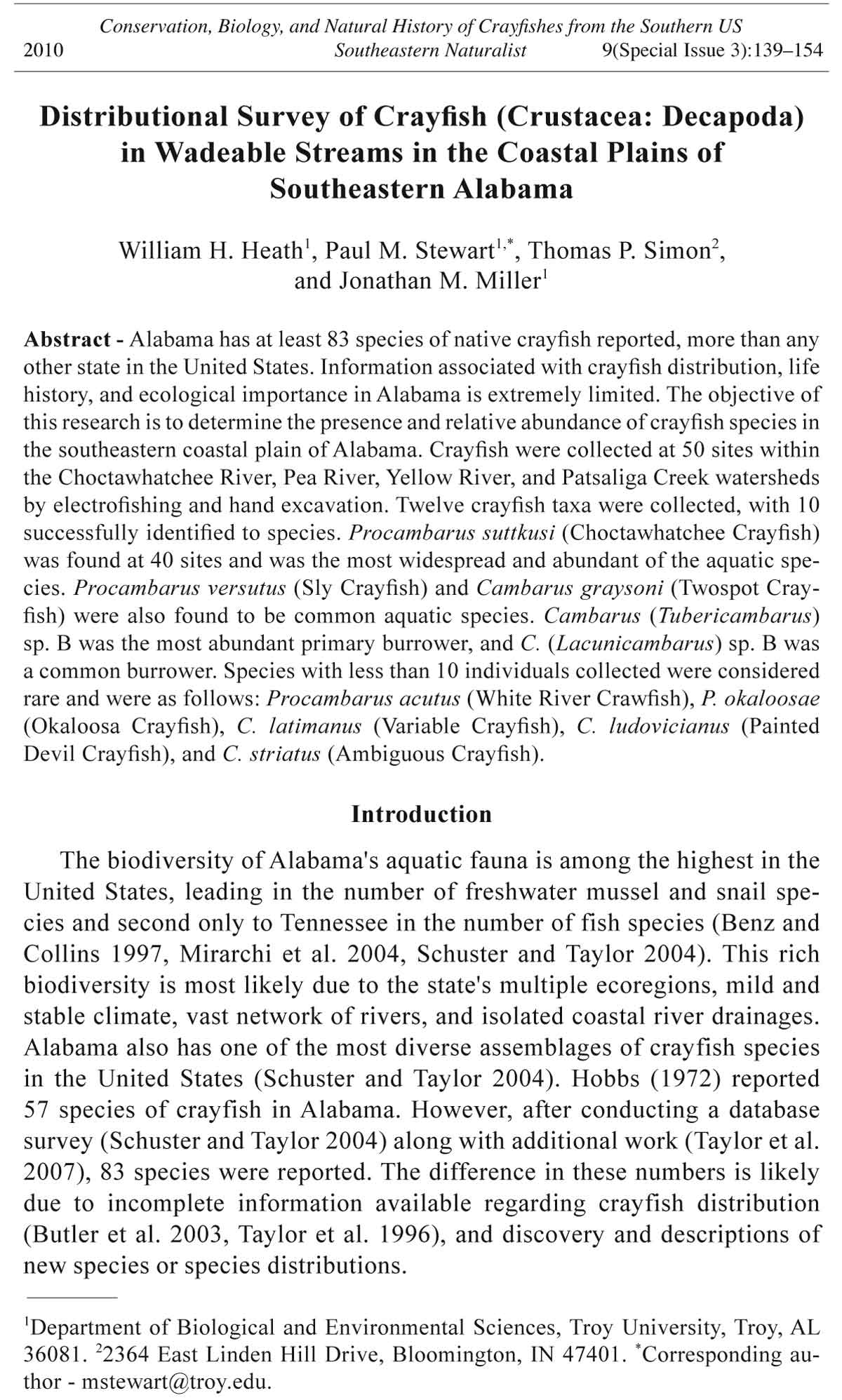
Fifty sites in the major wadeable streams that occur in the southeast
portion of the coastal plain in Alabama were sampled for crayfish (Fig. 1,
Appendix A). Thirty-one sites representative of common crayfish habitats
Figure 1. Map of Choctawhatchee River, Pea River, Yellow River, and Patsaliga
Creek watersheds showing sites sampled for crayfish from May to August 2004.
Darkened circles correspond to site information presented in Appendix A.
142 Southeastern Naturalist Vol. 9, Special Issue 3
were selected based on location, accessibility, and depth. The rest of the
sites were selected to coincide with a concurrent freshwater mussel survey
conducted by Troy University.
Sampling began at the bridge crossing and proceeded upstream at least
150 meters. When the upstream portion of the stream was inaccessible, the
same distance was sampled downstream. Electrofishing and hand excavation
of burrows on the banks within the riparian zone were the two most common
methods of collection. In instream habitats, a pulsed DC Smith-Root® backpack
electroshocker was used to stun and agitate the crayfish out of hiding
so they could be captured in a dip net. When crayfish chimneys were present,
a minimum of 5 burrows were excavated at each site (Simon and Thoma
2003). Crayfish were preserved in the field in 70% ethyl alcohol and then
transported to a laboratory for identification using dichotomous keys (Hobbs
1972, 1981). A voucher collection was retained in the Aquatics Laboratory
at Troy University, Troy, AL.
Results
Cambarus and Procambarus (both Cambaridae) were the only genera
found in the study area. A total of 1758 crayfish were collected. Six
species of Cambarus were found, along with a group that could not be
identified to species (due to lack of first-form males). Four species of
Procambarus were identified, as well as a group of specimens that could
not be identified to species. Of the 10 taxa identified, 6 were aquatic and
4 were primary burrowers.
Aquatic species
Procambarus suttkusi Hobbs (Choctawhatchee Crayfish) dominated the
study area. It was found at 40 of the 50 sites (80%), with a total of 1129
individuals (480 males, 528 females, and 121 juveniles) collected (Table 1,
Fig. 2). Procambarus suttkusi was found in all four watersheds, but was most
common in the Choctawhatchee and Pea River watersheds (Fig. 3).
Procambarus versutus (Hagen) (Sly Crayfish) was found next in relative
abundance. It was collected from 18 sites (36%), with 344 individuals found
in total (Table 1). There were 151 males, 155 females, and 38 juveniles
collected of this species (Fig. 2). Procambarus versutus was found in all 4
watersheds, but was most abundant in the Pea River, Patsaliga Creek, and
Yellow River watersheds (Fig. 4).
Cambarus graysoni Faxon (Twospot Crayfish) is one of two aquatic
Cambarus species that was found during this survey. One hundred and six individuals
(16 males, 47 females, and 43 juveniles) were collected at 14 sites in
the northern region of the Pea River watershed and the far northern and southern
regions of the Choctawhatchee River drainage (Table 1; Figs. 2, 5).
Only 7 individuals (3 males, 3 females, 1 juvenile) of Procambarus
acutus (Girard) (White River Crawfish) were collected at 3 sites on the eastern
edge of the Choctawhatchee River watershed (Table 1; Figs. 3, 6).
2010 W.H. Heath, P.M. Stewart, T.P. Simon, and J.M. Miller 143
Procambarus okaloosae Hobbs (Okaloosa Crayfish) was also only found
at 3 sites from the southern edge of the study area in the Choctawhatchee and
Yellow Rivers watersheds (Fig. 3, Table 1), and only 2 males and 2 females
were collected (Fig. 6).
Cambarus latimanus (LeConte) (Variable Crayfish) was the other aquatic
Cambarus species documented, and it was found at 3 sites: 2 sites within the
north-central portion of the Pea River watershed and 1 site in the eastern portion
of the Choctawhatchee River watershed (Fig. 5, Table 1). Six individuals
were collected, consisting of 1 male, 4 females, and 1 juvenile (Fig. 6).
Burrowing species
Cambarus (Tubericambarus) sp. B was the most abundant burrowing
species found. It was collected at 34 sites (Table 1), with 108 individuals
collected (53 males, 49 females, and 5 juveniles; Fig. 7). It was found in
all 4 watersheds, but was most abundant within the Choctawhatchee River
watershed (Fig. 8).
Cambarus (Lacunicambarus) sp. B was found at 12 sites throughout the
4 watersheds (Fig. 8, Table 1). Of the 28 individuals collected, there were 18
males, 9 females, and 1 juvenile (Fig. 7).
Table 1. List of species documented during the survey of 50 sites in the coastal plains of southeastern
Alabama. The first number is the site where the species was found and the number in
parenthesis is the number of individuals found at that site. See Appendix A for site information.
Species Site where species were collected
Cambarus (Lacunicambarus) sp. B 3(2), 4(1), 8(2), 10(1), 15(4), 16(2), 20(3), 21(2),
33(3), 50(3), 62(1), 63(4)
C. graysoni 13(4), 14(2), 15(11), 18(5), 19(21), 20(37), 24(2),
26(4), 31(4), 33(1), 35(1), 45(3), 48(9), 49(2)
C. latimanus 3(2), 11(3), 19(1)
C. ludovicianus 48(6)
C. striatus 35(1)
C. (Tubericambarus) sp. B 3(1), 4(8), 5(2), 6(2), 8(4), 9(4), 10(5), 11(4), 13(3),
14(6), 18(1), 19(3), 20(2), 21(3), 23(2), 30(4),
31(4), 32(1), 34(2), 35(3), 36(5), 39(4), 40(1),
41(4), 42(4), 43(4), 45(2), 46(3), 49(2), 60(5),
61(3), 62(1), 63(1), 64(5)
Cambarus spp. 7(4), 8(2), 17(3), 23(1), 34(1), 37(1), 40(1), 50(4),
62(1)
Procambarus acutus 11(1), 15(1), 20(5)
P. okaloosae 43(1), 46(2), 63(1)
P. suttkusi 3(19), 4(14), 5(41), 6(59), 7(30), 8(49), 10(31),
12(15), 13(51), 14(2), 16(40), 17(19), 18(54),
21(15), 23(27), 24(32), 25(50), 30(21), 31(41),
32(26), 33(41), 34(24), 35(87), 36(62), 37(11),
38(24), 39(28), 40(40), 41(12), 42(1), 44(25),
45(44), 46(2), 47(23), 50(26), 60(10), 61(8),
62(14), 63(1), 64(10)
P. versutus 6(19), 7(22), 11(13), 15(20), 23(7), 24(2), 25(21),
26(56), 30(17), 31(4), 33(10), 41(63), 45(5),
48(25), 60(14), 61(22), 62(12), 63(12)
Procambarus spp. 14(1)
144 Southeastern Naturalist Vol. 9, Special Issue 3
Figure 3. Distribution
map of Procambarus
acutus,
P. okaloosae, and
P. suttkusi specimens
collected
from May to August
2004 in the
Choctawhatchee
River, Pea River,
Yellow River, and
Patsaliga Creek
watersheds in the
coastal plains of
southeastern Alabama.
Figure 2. Comparison
of total
number of Procambarus
suttkusi,
P. versutus, and
Cambarus graysoni
broken down
by sex and stage
of each species
collected during
the 2004 summer
collection in the
Choctawhatchee
River, Pea River,
Yellow River, and
Patsaliga Creek
watersheds in the
coastal plains of
southeastern Alabama.
2010 W.H. Heath, P.M. Stewart, T.P. Simon, and J.M. Miller 145
Figure 4. Distribution
map of
Cambarus striatus,
Procambarus
versutus, and
Procambarus sp.
specimens collected
from May to
August 2004 in the
Choctawhatchee
River, Pea River,
Yellow River, and
Patsaliga Creek
watersheds in the
coastal plains of
southeastern Alabama.
Cambarus ludovicianus Faxon (Painted Devil Crayfish) was found at
only 1 site in the northern portion of the Choctawhatchee River watershed
(Fig. 8, Table 1). Of the 6 individuals found, there were 1 male, 3 females,
and 2 juveniles (Fig. 7).
A single female Cambarus striatus Hay (Ambiguous Crayfish) was found
(Table 1) within the eastern portion of the Choctawhatchee River watershed
(Figs. 4, 7).
Discussion
The results from this study were partially consistent with those of historical
records. Schuster and Taylor (2004) recently reported historical accounts
of 9 taxa of crayfish in the Choctawhatchee River watershed. During our
study, we found 10 crayfish taxa, with 5 taxa (C. (Lacunicambarus) sp. B,
C. latimanus, P. suttkusi, P. versutus, and P. acutus) overlapping between
the 2 studies. Species recorded in the historical record but not in this study
were Faxonella clypeata (Hay) (Ditch Fencing Crayfish), P. acutissimus
(Girard) (Sharpnose Crayfish), P. lophotus Hobbs and Walton (Mane Crayfish), and P. spiculifer (LeConte) (White Tubercled Crayfish) (Schuster and
Taylor 2004). Species sampled in this study but not found in the historical
record were P. okaloosae, C. graysoni, C. ludovicianus, C. striatus, and C.
146 Southeastern Naturalist Vol. 9, Special Issue 3
Figure 5. Distribution
map of
Cambarus sp., C.
latimanus, and C.
graysoni specimens
collected
from May to August
2004 in the
Choctawhatchee
River, Pea River,
Yellow River, and
Patsaliga Creek
watersheds in the
coastal plains of
southeastern Alabama.
Figure 6. Comparison
of total numbers
of remaining
aquatic species
by sex and stage.
C. l.= Cambarus
latimanus, C. sp.=
Cambarus sp., P.
o.= Procambarus
okaloosae, P.
a.= Procambarus
acutus, and P. sp.=
Procambarus sp.
specimens collected
May–August
2004 in the
Choctawhatchee
River, Pea River,
Yellow River, and
Patsaliga Creek
watersheds in the
coastal plains of
southeastern Alabama.
2010 W.H. Heath, P.M. Stewart, T.P. Simon, and J.M. Miller 147
Figure 7. Comparison
of total number
of burrowing
species with the
sex and stage of
each species. C. t.
sp. A = Cambarus
(Tubericambarus)
sp. B, C. d. = Cambarus
(Lacunicambarus)
sp. B, C. l.
= C. ludovicianus,
and C. s. = C. striatus
specimens collected
from May to
August 2004 in the
Choctawhatchee
River, Pea River,
Yellow River, and
Patsaliga Creek
watersheds in the
coastal plains of
southeastern Alabama.
Figure 8. Distribution
map of Cambarus
(Tubericambarus)
sp. B, C. ludovicianus,
and C.
(Lacunicambarus)
sp. specimens collected
from May to
August 2004 in the
Choctawhatchee
River, Pea River,
Yellow River, and
Patsaliga Creek
watersheds in the
coastal plains of
southeastern Alabama.
148 Southeastern Naturalist Vol. 9, Special Issue 3
(Tubericambarus) sp. B. The difference between our results and historical
data were likely due to the habitats sampled. Our study focused on wadeable
streams and included burrowing species found adjacent to the stream. Samples
were not taken from roadside ditches and swampy areas that were not
associated with streams or creeks.
Of the aquatic species documented, P. suttkusi was the most abundant and
widespread, clearly establishing it as the dominant aquatic species of the study
area. Procambarus versutus and C. graysoni were fairly abundant, but their
distributions were more limited. Sex ratios among P. suttkusi and P. versutus
were similar (about 1:1), but the sex ratio of C. graysoni was skewed towards
females. Procambarus acutus, P. okaloosae, and C. latimanus were found in
such small quantities that no such inferences could be made.
Cambarus (Tubericambarus) sp. B was the dominant primary burrower
and was distributed throughout the study area. Its sex ratio was similar to
that of the aquatic species, which was about 1:1, and about 10% were juveniles.
Cambarus (Lacunicambarus) sp. B was also found throughout the
study area, but in much smaller numbers and with twice as many males as
females excavated. Cambarus ludovicianus and C. striatus appeared to be
quite rare in our study area. Schuster and Taylor (2004) reported that C. ludovicianus
was of moderate conservation concern and C. striatus was very
common within Alabama. Both are more common to the Piedmont Region.
Procambarus suttkusi was the dominant aquatic crayfish species within
and west of the Choctawhatchee watershed. Historical records show that
the distribution of P. suttkusi was limited to the Choctawhatchee and
Chattahoochee Rivers in southeast Alabama and that it was of moderate
conservation concern (Schuster and Taylor 2004). Hobbs (1981) did not report
P. suttkusi in Georgia during his sampling of the Chattahoochee River.
Our study suggests that P. suttkusi has extended its range west to the Escambia
River watershed (Yellow River and Patsaliga Creek watersheds), and all
life stages collected in the watershed were abundant, including juveniles,
showing good reproduction. Even though this species was locally abundant
in our study, it is considered of special concern due to its previously reported
limited distribution (Baker et al. 2008).
Procambarus versutus was frequently found along with P. suttkusi and is
historically found in the same types of habitats (Hobbs 1942, Schuster and
Taylor 2004). According to Hobbs (1942), P. versutus had not been collected
in the Choctawhatchee River or the watershed. Our findings confirm Schuster
and Taylor's (2004) observation that P. versutus was commonly found
throughout the state.
Two crayfish that were rarely found during this study were P. acutus and
P. okaloosae. In general, both species inhabit lentic and lotic environments.
However, P. acutus is spread extensively, albeit sporadically, throughout
the state, while P. okaloosae has a more localized distribution (Hobbs 1981,
Schuster and Taylor 2004). The widespread, sporadic occurrence of P. acutus
may be attributed to its popularity as fishing bait and its economic significance
2010 W.H. Heath, P.M. Stewart, T.P. Simon, and J.M. Miller 149
in aquaculture (Taylor and Schuster 2004). It may also be migrating from the
adjacent Chattahoochee River watershed, where Hobbs (1981) documented
it to be of common occurrence. Procambarus okaloosae, on the other hand,
was reported to be found only in a couple of west Florida counties and only
one county in Alabama (Escambia) (Hobbs 1942). During the current study,
P. okaloosae was found in Covington, Coffee, and Houston counties. Houston
and Covington Counties both border west Florida, and Coffee County borders
Covington County on its northeast side, but does not border Florida. This finding
would suggest that the historical range of P. okaloosae extends further into
Alabama than was previously recorded or that it is undergoing range extension.
Hobbs (1942) also stated that P. okaloosae occurred in smaller aquatic
habitats such as ditches and small creeks. The specimens collected in this
study were found in small creeks with an average depth of less than 0.5 m.
According to Butler et al. (2003) and Ratcliffe and DeVries (2004),
aquatic species of the genus Cambarus are not typically found in the coastal
plain, but are commonly associated with the Piedmont areas of the state. The
coastal plains are more likely to be inhabited by Procambarus species (Butler
et al. 2003, Hendrix and Loftus 2000, Hobbs 1942). Cambarus graysoni
was the only aquatic Cambarus species found where >10 specimens were
collected. Cambarus graysoni is normally found in streams under rocks and
woody debris, but can also be a secondary burrower (Schuster and Taylor
2004, Taylor and Schuster 2004). All but one specimen, which was found in
a burrow on Patsaliga Creek in Crenshaw County, were collected in streams
throughout the watershed. Cambarus graysoni was collected throughout the
Choctawhatchee and Pea River drainages, but was usually found further
north in the Cumberland Plateau (Schuster and Taylor 2004).
Historically, C. latimanus and C. striatus are aquatic species with burrowing
tendencies (Schuster and Taylor 2004). These species were found in
limited numbers during this study. Cambarus latimanus was found among
woody debris mainly in sandy-bottomed streams with steeper banks, which
was consistent with historical records (Hobbs 1981). Cambarus striatus occurred
at only one site, which was on the East Fork of the Choctawhatchee
River in Henry County. Cambarus striatus was excavated from hard soil that
was densely meshed with roots. Hobbs (1981) found them in similar habitats
from collections made in Georgia. Taylor and Schuster (2004) reported C.
striatus as having a sporadic distributional pattern, which may explain why
there was only one found in this study.
Cambarus (Tubericambarus) sp. B was the most widely found burrowing
crayfish in southeast Alabama, but is perhaps one of the least studied. It
is a primary burrower and is thought to range from Michigan to the Gulf of
Mexico, but its exact distribution is unknown. This species is currently being
described (Schuster and Taylor 2004, Taylor and Schuster 2004).
Cambarus ludovicianus was found in Pike County at only one location.
This site was a low swampy area beside a creek that had standing water
outside of the main channel. Taylor and Schuster (2004) reported finding this
150 Southeastern Naturalist Vol. 9, Special Issue 3
species in a similar habitat in Kentucky along the Mississippi River. Historical
records place the species in the Mobile, Alabama, and Tombigbee rivers
in Greene, Montgomery, Pickens, and Washington counties of Alabama
(McGregor et al. 1999).
Conclusions
Ten crayfish species and 2 unidentified taxa totaling over 1750 individuals
were collected from 50 sites within the Choctawhatchee, Pea, and
Yellow River, and Patsaliga Creek watersheds of southeastern Alabama.
The aquatic taxa collected were P. suttkusi, P. versutus, P. acutus, P. okaloosae,
C. latimanus, and C. graysoni. Burrowing taxa collected were C.
(Tubericambarus) sp. B, C. (Lacunicambarus) sp. B, C. ludovicianus, and
C. striatus. Procambarus suttkusi was the dominant aquatic species, and C.
(Tubericambarus) sp. B was the dominant burrowing species. Five of the
taxa (C. [Lacunicambarus] sp. B, C. latimanus, P. suttkusi, P. versutus, and
P. acutus) collected were listed in historical records. Fallicambarus clypeata,
P. acutissimus, P. lophotus, and P. spiculifer were found historically,
but not in this study. Procambarus okaloosae, C. graysoni, C. ludovicianus,
C. striatus, and C. (Tubericambarus) sp. B were newly recorded for the watersheds
sampled during this study. The discrepancy between this study and
historical records was most likely due to this study only covering wadeable
streams and not a broader array of aquatic habitats.
Alabama has the most diverse crayfish population of any state in the
US (Schuster and Taylor 2004). Crayfish research has been minimal;
therefore, abundance, distribution, and life-history studies are needed to
determine current distributions and abundance. Accurate data are needed
to determine what conservation measures are warranted to preserve the
rich diversity unique to this state. This study has provided evidence that
some crayfish species have expanded their range in comparison to historical
data. It also points out the need to include the burrowers in all crayfish
surveys, as they are the most neglected group and yet comprise a substantial
portion of the species diversity in an area.
Acknowledgments
We thank two anonymous reviewers for suggestions to the manuscript, Guenter
Schuster and Roger Thoma for crayfish verifications, and Stuart Welsh for publication
support. The publication of this manuscript was supported, in part, by the US
Geological Survey Cooperative Research Unit Program, including the West Virginia
Cooperative Fish and Wildlife Research Unit.
Literature Cited
Baker, A.M., P.M. Stewart, and T.P. Simon. 2008. Life-history study of Procambarus
suttkusi in southeastern Alabama. Journal of Crustacean Biology 28:451–460.
Benz, G.W., and D.E. Collins. 1997. Aquatic Fauna in Peril: The Southeastern Perspective.
Southeast Aquatic Research Institute Special Publication 1. Decatur,
GA. 554 pp.
2010 W.H. Heath, P.M. Stewart, T.P. Simon, and J.M. Miller 151
Butler, R.S., R.J. DiStefano, and G.A. Schuster. 2003. Crayfish: An overlooked
fauna. Endangered Species Bulletin 28(2):10–11.
Cronin, G., D.M. Lodge, M.E. Hay, M. Miller, A.M. Hill, T. Horvath, R.C. Bolser, N.
Lindquist, and M. Wahl. 2002. Crayfish feeding preferences for freshwater macrophytes:
The influence of plant structure and chemistry. Journal of Crustacean
Biology 22:708–718.
DiStefano, R.J., J.J. Decoske, T.M. Vangilder, and L.S. Barnes. 2003. Macrohabitat
partitioning among three crayfish species in two Missouri streams, USA. Crustaceana
76:343–362.
Harris, S.C. 1990. Preliminary considerations of rare and endangered invertebrates
in Alabama. Journal of the Alabama Academy of Science 61:64–92.
Helfrich, L.A., and R.J. DiStefano. 2003. Sustaining America's aquatic biodiversity,
crayfish biodiversity, and conservation. Virginia Polytechnic Institute and State
University, Blacksburg, VA. Publication # 420–524. 6 pp.
Hendrix, A.N., and W.F. Loftus. 2000. Distribution and relative abundance of the
crayfishes Procambarus alleni (Faxon) and P. fallax (Hagen) in southern Florida.
Wetlands 20:194–199.
Hobbs, H.H., Jr. 1942. The crayfishes of Florida. University of Florida Publications,
Biological Science Series 3(2):1–179.
Hobbs, H.H., Jr. 1972. Crayfishes (Astacidae) of North and Middle America. Biota of
Freshwater Ecosystems, Identification Manual No. 9, US Environmental Protection
Agency, Washington, DC. 173 pp.
Hobbs, H.H., Jr. 1981. The crayfishes of Georgia. Smithsonian Contributions to
Zoology 318:1–549.
Holdich, D.M. (Ed.). 2002. Biology of Freshwater Crayfish. Blackwell Science, Ltd.
Osney Mead, Oxford, UK. 702 pp.
Lodge, D.M., C.A. Taylor, D.M. Holdich, and J. Skurdal. 2000. Reducing impacts of
exotic crayfish. Fisheries 25(8):21–23.
Mirarchi, R.E., J.T. Garner, M.F. Mettee, and P.E. O'Neil. 2004. Alabama Wildlife
Volume 2. Imperiled Aquatic Mollusks and Fishes. University of Alabama Press,
Tuscaloosa, AL. 255 pp.
McGregor, S.W., T.E. Shepard, T.D. Richardson, and J.F. Fitzpatrick, Jr. 1999. A
survey of the primary tributaries of the Alabama and Lower Tombigbee Rivers
for freshwater mussels, snails, and crayfish. Circular 196, Geological Survey of
Alabama, Environmental Geology Division. Tuscaloosa, AL.
Mettee, M.F., P.E. O'Neil, and J.M. Pierson. 1996. Fishes of Alabama and the Mobile
River Basin. Oxmoor House. Birmingham, AL. 820 pp.
Poly, W.J., and J.E. Wetzel. 2003. Distribution and taxonomy of three species of
Orconectes (Decapoda: Cambaridae) in Illinois, USA. Journal of Crustacean
Biology 23:380–390.
Ratcliffe, J.A., and D.R. DeVries. 2004. The crayfishes (Crustacea: Decapoda) of the
Tallapoosa River drainage, Alabama. Southeastern Naturalist 3:417–430.
Riggert, C.M., R.J. DiStefano, and D.B. Noltie. 1999. Distributions and selected
aspects of the life histories and habitat associations of the crayfish Orconectes
peruncus (Creaser, 1931) and Orconectes quadruncus (Creaser, 1933) in Missouri.
American Midland Naturalist 142:348–362.
Schuster, G.A., and C.A. Taylor. 2004. Report on the crayfishes of Alabama: Literature
and museum database review, species list with abbreviated annotations,
and proposed conservation status. Prepared for State of Alabama, Department of
Conservation and Natural Resources, Wildlife and Freshwater Fisheries Division.
Illinois Natural History Survey, Champaign, IL. Center for Biodiversity
Technical Report 2004 (12).
152 Southeastern Naturalist Vol. 9, Special Issue 3
Schuster, G.A., C.A. Taylor, and J. Johansen. 2008. An annotated checklist and
preliminary designation of drainage distributions of the crayfish of Alabama.
Southeastern Naturalist 7:493–504.
Simon, T.P., and R.F. Thoma. 2003. Distribution of freshwater shrimp and crayfish
(Decapoda: Cambaridae) in the Patoka River basin of Indiana. Proceedings of the
Indiana Academy of Science 2:175–185.
Taylor, C.A., and G.A. Schuster. 2004. The Crayfishes of Kentucky. Illinois Natural
History Survey. Champaign, IL. 220 pp.
Taylor, C.A., M.L. Warren, J.F. Fitzpatrick, H.H. Hobbs III, R.F. Jezerinac, W.L.
Pflieger, and H.W. Robinson. 1996. Conservation status of crayfishes of the
United States and Canada. Fisheries 21(4):25–38.
Taylor, C.A., G.A. Schuster, J.E. Cooper, R.J. DiStefano, A.G. Eversole, P. Hamr,
H.H. Hobbs III, H.W. Robison, C.E. Skelton, and R.F. Thoma. 2007. A reassessment
of the conservation status of crayfishes of the United States and Canada
after 10+ years of increased awareness. Fisheries 32(8):372–389.
US Department of Agriculture, Soil Conservation Service, and State of Alabama
Department of Economic and Community Affairs. 1995. State of Alabama hydrologic
unit map with drainage areas by counties and sub-watersheds. Montgomery,
AL.
US Fish and Wildlife Service. 2004. Threatened and endangered species system, Division
of Endangered Species. Available online at http://ecos.fws.gov/tess_public/
TESSSpeciesReport. Accessed November 2004.
2010 W.H. Heath, P.M. Stewart, T.P. Simon, and J.M. Miller 153
Appendix A. Site number, county, stream name, direction to stream, latitude, and
longitude, for 50 sites sampled in the Choctawhatchee River, Pea River, Yellow
River, and Patsaliga Creek watersheds during the 2004 crayfish survey in southeastern
Alabama.
Site Location
3 Pike: Persimmon Branch, George C. Wallace Drive Bridge, 2.25 km E of
Troy, N 31°48.373', W 085°56.940'
4 Barbour: Blue Springs Creek, Blue Springs State Park, 0.8 km W of Blue
Springs, N 31º 39.724', W 085º 30.359'
5 Barbour: West Fork Choctawhatchee River, State Highway 10 Bridge, 0.64
km SW of Blue Springs, N 31º 39.765', W 085º 30.332'
6 Bullock: Little Sandy Creek, County Road 50 Bridge, 17.7 km S of Union
Springs, N 31°59.673', W 085°40.489'
7 Bullock: Pea River, County Road 34 Bridge, 5.47 km SW of Midway, N
32°03.054', W 085°34.195'
8 Barbour: Tributary to Lindsey Creek, County Road 53 Bridge, 5.63 km
South of Clayton, N 31°49.351', W 085°26.560'
9 Barbour: East Fort Choctawhatchee River, State Highway 30 Bridge, 8.53
km E of Clayton, N 31°52.095', W 085°21.793'
10 Barbour: Wallace Creek, County Road 43 Bridge, 5.95 km E of Blue
Springs, N 31°40.008', W 085°26.348'
11 Henry: Jack Creek, end of County Road 75 Bridge, 12.87 km W of Abbeville,
N 31°35.481', W 085°22.977'
12 Dale: Claybank Creek, US Highway 231 Bridge, 6.12 km SW of Ariton, N
31°33.002', W 085°44.420'
13 Barbour: Danner Creek, County Road 3 Bridge, 6.92 km SW of Elamville,
N 31°38.449', W 085°42.871'
14 Dale: Blacks Creek, County Road 95 Bridge, 4.35 km E of Ariton, N
31°38.454', W 085°42.873'
15 Barbour: Hamm Creek, State Highway 131 Bridge, 4.67 km NE of Texasville,
N 31°44.681', W 085°, 23.398'
16 Barbour: Tributary to Williams Millpond Creek, McSwain Creek Road
Bridge, 11.75 km SE of Clayton, N 31°47.606', W 085°22.736'
17 Coffee: Wilberts Creek, County Road 544 Bridge, 9.17 km SW of New
Brockton, N 31°19.534', W 085°59.861'
18 Pike: Tributary to Walnut Creek, County Road 111 Bridge, 3.86 km SE of
Mossy Grove, N 31°43.498', W 085°56.331'
19 Coffee: Tributary to Whitewater Creek, State Highway 167 Bridge, 27.36
km NE of Elba, N 31°33.798', W 085°55.485'
20 Henry: Cowpen Creek, County Road 81 Bridge, 5.15 km W of Lawrenceville,
N 31°39.044', W 085°19.284'
21 Henry: Watson Creek, State Highway 27 Bridge, 9.98 km SW of Abbeville,
N 31°30.793', W 085°19.763'
22 Henry: Camp Branch, Unnamed County Road Bridge, 4.51 km W. of
Newville, N 31°25.851', W 085°22.267'
23 Geneva: 10 Mile Creek, State Highway 167 Bridge, 8.37 km E of Black, N
31°00.449', W 085°39.451'
24 Geneva: Barnes Creek, County Road 41 Bridge, 8.53 km W of Hartford, N
31°07.484', W 085°46.830'
25 Coffee: Cripple Creek, State Highway 189 Bridge, 1.29 km E of Kinston, N
31°13.563', W 086°09.688'
26 Coffee: Tributary to Helms Mill Creek, County Road 409 Bridge, 7.08 km
SW of Elba, N 31°22.013', W 086°07.863'
154 Southeastern Naturalist Vol. 9, Special Issue 3
Site Location
30 Crenshaw: Patsaliga Creek, State Highway 106 Bridge, 14.16 km E of
Brantley, N 31°35.768', W 086°24.286'
31 Pike: Pea River, State Road 10 Bridge, 9.17 km W of Clio, N 31°42.868',
W 085°42.448'
32 Barbour: Pea Creek, County Road 9 Bridge, 9.17 km W of Louisville, N
31°47.744', W 085°39.167'
33 Pike: Big Creek, County Road 6 Bridge, 3.54 km SW of Spring Hill, N
31°40.688', W 085°59.696'
34 Barbour: Big Creek, County Road 3 Bridge, 4.51 km NW of Clio, N
31°43.507', W 085°39.273'
35 Henry: East Fork Choctawhatchee River, County Road 54 Bridge, 7.40 km
W of Lawrenceville, N 31°40.667', W 085°20.726'
36 Dale: Judy Creek, County Road 15 Bridge, 10.78 km NE of Ozark, N
31°31.592', W 085°35.009'
37 Dale: West Fork Choctawhatchee River, County Road 60 Bridge, 9.01 km
E of Skipperville, N 31°33.288', W 085°28.916'
38 Dale: West Fork Choctawhatchee River, State Rt 27 Bridge, 11.27 km SE of
Ozark, N 31°24.644', W 085°32.123'
39 Dale: East Fork Choctawhatchee River, County Road 83 Bridge, 13.04 km
NE of Midland City, N 31°24.645', W 085°26.123'
40 Geneva: Hurricane Creek, State Highway 123 Bridge, 4.99 km NE of Hartford,
N 31°07.761', W 085°39.397'
41 Covington: Yellow River, US 84 bridge, 9.01 km W of Opp, N 31°16.432',
W 086°20.932'
42 Dale: Little Choctawhatchee River, County Road 10 Bridge, 8.05 km SE of
Midland City, N 31°17.200', W 085°25.143'
43 Houston: Beaver Creek, Honeysuckle Road Bridge, 4.18 km W of Dothan,
N 31°12.875', W 085°26.072'
44 Geneva: Bell Creek, County Road 728 Bridge, 2.57 km NE of Bellwood, N
31°11.284', W 085°48.791'
45 Geneva: Tributary to Spring Creek, County Road 6 Bridge, 5.31 km E of
Geneva, N 31°02.576', W 085°48.513'
46 Coffee: Beaverdam Creek, County Road 660, 10.94 km SW of Enterprise,
N 31°13.233', W 085°53.488'
47 Coffee: Blanket Creek, State Highway 192 Bridge, 3.54 km SW of Enterprise,
N 31°17.915', W 085°53.055'
48 Pike: Buckhorn Creek, County Road 6621 Bridge, 9.50 km NE of Banks, N
31°48.013', W 085°43.766'
49 Pike: Tributary to Buckhorn Creek, Unnamed County Road Bridge, 12.23
km NE of Brundige, N 31°48.013', W 085°43.766'
50 Pike: Mims Creek, County Road 59 Bridge, 6.92 km SW of Brundidge, N
31°40.878', W 085°52.186'
60 Crenshaw: Little Patsaliga Creek, County Road 35 Bridge, 7.72 km SW of
Luverne, N 31°41.155', W 086°20.098'
61 Crenshaw: Little Patsaliga Creek, State Highway 10 Bridge, 7.00 km W of
Luverne, N 31°43.712', W 086°19.845'
62 Crenshaw: Patsaliga Creek, County Road 59 Bridge, 8.21 km NE of Luverne,
N 31°46.858', W 086°13.437'
63 Covington: Hollis Creek, County Road 73 Bridge, 9.17 km W of Opp, N
31°16.778', W 086°21.251'
64 Barbour: Hurricane Creek, State Highway 239 Bridge, 13.36 km W of Clayton,
N 31°54.356', W 085°35.082'


 The Southeastern Naturalist is a peer-reviewed journal that covers all aspects of natural history within the southeastern United States. We welcome research articles, summary review papers, and observational notes.