Conservation, Biology, and Natural History of Crayfishes from the Southern US
2010 Southeastern Naturalist 9(Special Issue 3):199–216
Reach- and Watershed-scale Associations of Crayfish
within an Area of Varying Agricultural Impact in
West-central Indiana
Jacob L. Burskey1,* and Thomas P. Simon2
Abstract - We studied the associations of crayfish with reach-scale instream habitat
and water quality variables and watershed-scale variables of riparian and watershed
land cover, runoff, impervious surfaces, and hydrologic soil type in west-central Indiana.
Crayfish assemblage was measured by abundance, species richness, and diversity
(Shannon’s H) at 180 sites. The western portion of the study area, within the Interior
River Lowland ecoregion, has been heavily impacted by agriculture, while the eastern
portion, within the Interior Plateau ecoregion, is more heavily wooded and less
impacted. The ability of variables at each spatial extent to predict crayfish assemblage
was assessed using multiple linear regression analysis. Reach-scale models were better
predictors of crayfish assemblage than watershed-scale models. A variety of habitat
and water quality characteristics, principally instream cover, appeared as important
predictors. Forested riparian and watershed land appeared as significant watershedscale
predictors. Reach-scale models were also better predictors of individual species
abundance. Model predictive power was similar when developed separately for the
two ecoregions of the study area, indicating that extent of agricultural development
had little effect on the ability of variables at a given spatial scale to predict crayfish assemblage.
Results indicate that reach-scale variables are more powerful in predicting
crayfish assemblage, and important factors to consider in crayfish management are
maintaining ample instream cover and intact riparian areas.
Introduction
Crayfish serve a key role in stream communities, and nearly 50% of the
crayfish taxa of the United States and Canada are recognized as endangered,
threatened, or of special concern (Taylor et al. 1996). Because restoration and
protection efforts tend to focus at the scale where degradation is perceived
(Fausch et al. 2002), it is important to understand the relative influences
of environmental aspects on faunal assemblages at varying spatial scales.
As the availability of remotely sensed data has increased, so has its use in
investigating influences of abiotic variables at differing scales on aquatic
biota. Such studies have been conducted using fish communities (Brazner
et al. 2005, Eikaas et al. 2005, Frimpong et al. 2005, Lammert and Allan
1999, Wang et al. 2003), aquatic macroinvertebrates (Johnson and Goedkoop
2002, Lammert and Allan 1999, Richards et al. 1997, Stewart et al. 2000,
Stone et al. 2005, Weigel et al. 2003), and freshwater mussels (McRae et al.
2004) with varying results.
1Aquatic Research Center, Indiana Biological Survey, 6440 Fairfax Road, Bloomington,
IN 47401. 22364 East Linden Hill Drive, Bloomington, IN 47401. *Corresponding
author - jburskey1@gmail.com.
200 Southeastern Naturalist Vol. 9, Special Issue 3
Associations of crayfish have been shown to correspond with several
aspects of the abiotic environment, principally instream refuge cover defined
by large substrates, woody debris, undercut banks, root mats and root wads,
and submergent and emergent aquatic macrophytes (Hill and Lodge 1994).
Hill and Lodge (1994) reported that crayfish abundance was positively correlated
with refuge abundance and negatively correlated with predatory
fish abundance. Stein and Magnuson (1976) reported that in the presence
of a fish predator, crayfish selected larger substrates that provided the most
protection from predation. Crayfish are often associated with lower-order
streams and can reach high densities in intermittent waters where fish predators
are scarce (Flinders and Magoulick 2003). Crayfish are also influenced
by factors such as temperature, dissolved oxygen, pH, salinity, and organic
and heavy metal contamination (Lodge and Hill 1994). Effects of poor water
quality vary by species, and there is evidence of a top-down effect whereby
certain species of crayfish can proliferate in contaminated waters where fish
populations remain depressed (Seiler and Turner 2004).
The goals of this study were as follows: 1) determine the relative abundances
of co-occurring crayfish species within a 6-county area of west-central
Indiana; 2) assess the ability of habitat variables quantified at reach and watershed
scales to predict crayfish assemblage structure and species abundance;
and 3) examine the predictive power of reach- and watershed-scale variables
in portions of the study area with different land-use patterns. Our hypotheses
were that crayfish would be positively associated with high-quality reach
habitat containing ample instream cover, a variety of substrates, and an intact
riparian corridor and negatively associated with agricultural land use.
Methods
Study area
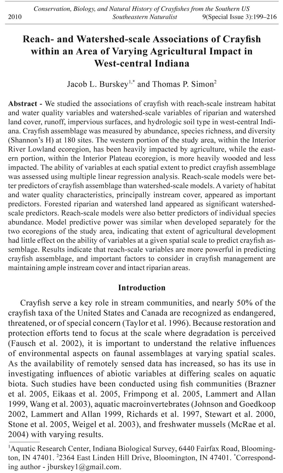
The study area was located within the boundaries of the Indiana counties
of Clay, Greene, Knox, Owen, Sullivan, and Vigo (Fig. 1). The area contains
portions of 4 level-three ecoregions defined by Omernik and Gallant (1988).
The Interior River Lowland (IRL), Central Corn Belt Plain (CCBP), and
Eastern Corn Belt Plain (ECBP) cover the western portion of the study area.
These regions are characterized by lower topographic diversity, sediments
of glacial till, and a diversity of land use, much of which is agricultural
(Omernik and Gallant 1988). On average, 44% of watershed land cover was
forest in the IRL, CCBP, and ECBP in this study (Table 1). The Interior Plateau
(IP) ecoregion covers the eastern portion of the study area and remained
largely unglaciated during the Pleistocene epoch. Topographic diversity is
often greater in this ecoregion and much of the Interior Plateau is underlain
with thick karst topography where underground caverns, sinkholes, and
springs are common. Forested land is more common in the IP, with an average
of 82% forest in IP watersheds in this study (Table 1). Agricultural land
in the IP is largely pasture and grazing land (Omernik and Gallant 1988).
Sites were selected using a random design to capture the range of conditions
in the area. Each bridge crossing over a wadeable stream shown on a
2010 J.L. Burskey and T.P. Simon 201
Table 1. Mean, standard error (SE), transformation (Trans.), and significance of P-values for
variables between Interior River Lowland (IRL) (n = 145) and Interior Plateau (IP) (n = 35)
regions. Asterisks denote variables retained for model development.
Variable Region Mean SE Trans. t df P
% watershed wetlands* IRL 12.57 0.67 arcsin(√x) 4.03 178 <0.001
IP 6.92 0.77
% watershed agriculture IRL 77.49 1.67 arcsin(√x) 7.09 177 <0.001
IP 50.92 3.42
% watershed grass IRL 51.88 1.00 arcsin(√x) 3.19 177 0.002
IP 45.03 1.57
% watershed forest* IRL 44.09 1.76 arcsin(√x) -9.54 178 <0.001
IP 82.44 3.91
Watershed area (acres)* IRL 823.40 9.96 Ln(x) 0.46 178 0.648
IP 813.00 21.70
% impervious area IRL 307.80 19.80 arcsin(√x) 2.94 178 0.004
IP 191.30 1.68
Runoff* IRL 5.00 0.11 3.56 178 0.001
IP 4.13 0.18
% soil B* IRL 41.35 4.68 arcsin(√x) 1.71 178 0.088
IP 24.53 5.85
% soil C IRL 20.83 4.66 arcsin(√x) -1.73 178 0.085
IP 45.61 5.75
% riparian wetlands* IRL 19.26 2.27 arcsin(√x) 3.23 175 0.001
IP 4.42 1.77
% riparian agriculture IRL 64.40 3.96 arcsin(√x) 1.96 175 0.052
IP 48.64 3.61
% riparian grass IRL 41.32 2.28 arcsin(√x) -2.7 175 0.008
IP 54.61 3.89
% riparian forest* IRL 47.28 3.21 arcsin(√x) -3.68 175 <0.001
IP 72.58 5.18
Substrate score* IRL 8.88 0.36 -6.71 177 <0.001
IP 14.26 0.71
Cover score* IRL 9.69 0.26 -2.82 177 <0.001
IP 11.28 0.46
Channel score IRL 12.73 0.30 -6.56 177 <0.001
IP 16.78 0.32
Bank/riparian score IRL 13.2 0.44 -3.73 178 <0.001
IP 16.68 0.60
Riffle/run score* IRL 7.70 0.26 -2.64 178 0.009
IP 9.24 0.51
Oxygen saturation (%)* IRL 87.73 1.90 -1.23 169 0.221
IP 92.37 1.59
pH* IRL 7.83 0.03 -1.54 167 0.126
IP 7.93 0.04
Salinity (mg/L) IRL 0.82 0.41 Ln(x) 0.828 169 0.409
IP 0.17 0.01
Temperature (°C)* IRL 20.23 0.29 Ln(x) 0.97 169 0.333
IP 19.63 0.47
Conductivity (mS/cm)* IRL 1.30 0.58 0.858 169 0.392
IP 0.34 0.02
ORP (mV) IRL 318.30 6.72 2.45 164 0.015
IP 285.40 6.46
TDS (ppm) IRL 0.52 0.05 3.27 169 0.001
IP 0.20 0.01
202 Southeastern Naturalist Vol. 9, Special Issue 3
1:156,000 unit topographic map within the boundaries of each county was
marked. Thirty sites within the boundaries of each of the 6 counties were
selected randomly from the numbered crossings using a random number
generator. Sites were not weighted for county or land area because the large
number of sample locations (n = 180 sites) was sufficient for obtaining a
representative sample of habitat and crayfish within the study area. This
study design also increased the range of stream sizes sampled; thus, we decreased
bias that would result from targeted sampling of a particular stream
order. Thirty-five sites were within the IP, 140 were within the IRL, four in
the CCBP, and one in the ECBP ecoregion (Fig. 1). Ecoregion delineations
are not precise, and there is a transition area between zones (Omernik and
Gallant 1988). Given the relatively small amount of CCBP and ECBP within
the study area, similarity of both to the IRL, and inexact ecoregion delineation,
we chose to group the sites within the ECBP and CCBP with those of
the IRL. For purposes of analysis, the 145 sites outside of the IP are referred
to as IRL sites.
Crayfish sampling
Crayfish were collected during May and June, 2006. The method for sampling
followed Simon (2004), a manual outlining standard operating procedure
Figure 1. West-central Indiana study area. Patterns denote ecoregion: light gray =
Interior River Lowland, stippled = Central Corn Belt Plain, striped = Eastern Corn
Belt Plain, and dark grey = Interior Plateau. Filled circles denote collection sites.
2010 J.L. Burskey and T.P. Simon 203
for collection of burrowing and stream-dwelling crayfish. Open-water habitat
was sampled using a Smith Root back-pack unit equipped with an 800-watt
generator capable of 300 volts and 3–5 amps. The electrofishing technique allows
for quantification of catch-per-unit-effort (CPUE; individuals/minute)
and is an effective way to sample crayfish in sluggish water (Simon 2004).
Open-water sampling was constrained by stream size and defined using wetted
width. Average wetted width (m) was first estimated and multiplied by 15, then
the resulting number was rounded up to the nearest 50-m increment and used
to define sample reach length. Reach length consisted of a minimum distance
of 50 m in smaller streams (<3.34 m wetted width) and a maximum of 200 m
in the largest streams encountered in this study (>10 m wetted width). Fifteen
times the stream wetted width has been shown to adequately include 2 full
habitat cycles (riffle-run-pool sequences; Leopold et al. 1964) and was deemed
sufficient to obtain a representative crayfish sample. Stream wetted width averaged
4.9 m (standard deviation of 2.8, range of 2–12.5 m), and sample reach
length averaged 90 m (standard deviation of 46.2, range of 50–200 m). Areas
near bridges that appeared to be atypical of the stream (wider and deeper water)
were not sampled in order to limit the effect of the bridge crossing on the data.
Large rocks and woody debris were flipped during sampling to attempt to capture
all resident crayfish. Hand nets were used to capture crayfish stimulated by
electrofishing and to dislodge them from under cover. Length of time spent on
aquatic sampling varied from 300–1800 seconds depending on stream size and
habitat complexity.
Burrow sampling was done using a spade and bucket to excavate borrows
and capture the resident crayfish. Active burrows were those free of plants
and debris and usually possessed mud exit holes in the shape of a “chimney.”
Excavation of ten burrows or a maximum of 120 minutes of burrow searching
was done at each location.
All crayfish were preserved in 70% ethanol for laboratory identification.
Specimens were identified to species level using Page (1985) and Pflieger
(1996). All specimens were deposited in the Crustacean Division of the Indiana
Biological Survey, Aquatic Research Center.
Assemblage quantification
Three measures of crayfish assemblage structure were calculated for
each reach. CPUE was calculated in two different ways to accommodate
differences in crayfish ecology between burrowing and stream-dwelling
species. CPUE for open-water crayfish was defined as individuals captured/
minute using backpack electrofishing methods. Because burrowing crayfish
are usually not collected from open water, the number of crayfish collected
from burrows using the spade-plunger method was used as the abundance
measure for primary burrowing species. Relative abundance of the most
common species (>20 sites) in terms of CPUE for stream species and number
of crayfish captured from burrows for primary burrowing species was used
to develop individual species prediction models. Species richness was the
number of crayfish species found in each reach, including both open-water
204 Southeastern Naturalist Vol. 9, Special Issue 3
and burrowing species. Diversity at each site was calculated using Shannon’s
diversity index, which takes into account the relative abundances of each
species in relation to the total sample:
H = -Σ pi* Ln(pi),
where pi is the proportion of the ith species in the total sample, and Ln is
natural log. Diversity included both open-water and burrowing crayfish.
Watershed-scale variables
Watershed-scale variables were quantified using a web-based, watershed
delineation program (Choi and Engle 2003). The program uses a double-seed
array method based on 30-m resolution digital elevation data. Once the watershed
was delineated, land cover was determined using 1992 USGS 30-m
resolution National Land Cover layers. Soil associations were based on 1994
Natural Resources Conservation Service data. Hydrologic soil types in the
study are mainly B and C, and percentage of each was calculated for the total
watershed. Soil types range from A to D, with textural sizes and permeability
decreasing from A to D (Soil Conservation Service 1986); thus, soil group B
has a larger texture and higher infiltration rate than group C. Percent land use
within each watershed in the form of water-wetlands, forest, grass-pasture,
and agriculture were calculated. Total watershed area was calculated and
used as a proxy for stream size. Percent impervious surfaces within each
watershed were calculated from land-use data. The percentage of hydrologic
soil group, land use, and USGS average rainfall data were used to calculate
average annual runoff depth (Choi and Engle 2003):
Q = (P - la)2 / ((P - la) + S),
where Q is runoff (in), P is rainfall (in), S is potential maximum retention
after runoff begins, and la is initial abstractions.
Individual watersheds were imported into ArcView 9.2 (Environmental
Systems Research Institute 2006) in order to calculate riparian land cover.
A 500-m reach was delineated at each site and a 150-m buffer applied to the
stream segment. Riparian land cover within the 150-m segment on each side
of the stream was calculated using 1992 USGS 30-m resolution National
Land Cover data (Choi and Engle 2003).
Reach-scale variables
Habitat assessment of instream and riparian areas was done using the
qualitative habitat evaluation index (QHEI; Rankin 1995). The QHEI is
commonly used in the Midwest United States to evaluate factors of habitat
that are important to aquatic life based on in situ field assessment. There are
5 metrics scored at each reach that are based on assessments of substrate,
instream cover, channel morphology, pool and riffle quality, bank and riparian
quality, and gradient. Gradient was not used in this study because of its
lack of variability through most of the study area. Following Frimpong et
al. (2005), the bank and riparian score was doubled, providing a maximum
score of 20 to make all five individual QHEI metrics equal in scale and retain
2010 J.L. Burskey and T.P. Simon 205
the total QHEI range of 0–100. Reach water quality measures including
water temperature, conductivity, oxidation-reduction potential (ORP), total
dissolved solids (TDS), salinity, and dissolved oxygen saturation were assessed
at each site prior to sampling using a YSI 556 multi-parameter meter
(Yellow Springs Instruments Inc., Yellow Springs, OH).
Predictive model development
Independent variables were compared between the IRL and IP regions
using an independent means t-test. Because we were concerned only with
describing the differences between abiotic conditions between the IRL and
IP, we decided not to control type I error by adjusting P-value threshold
because of the increase in type II error that results (Perneger 1998). Prior to
model development, all variables were examined and transformations were
applied where necessary to achieve normality.
For both the watershed and reach models, when two variables correlated
at 0.60 or higher (Pearson’s r), a single variable was retained to control for
collinearity. Percentage of forest and agricultural land were highly negatively
correlated (r = -0.771), and % grass-pasture was highly correlated with %
agricultural land (r = 0.686), so forest cover was retained for model development.
Percentage of impervious area was highly correlated with runoff (r =
0.650), so runoff was retained. Percentage of soil group B and C were nearly
perfectly negatively correlated so % soil group B was retained. Salinity was
highly correlated with conductivity (r = 0.991), total dissolved solids (r =
0.991), and oxidation reduction potential (r = 0.669), so conductivity was retained
as an overall measure of dissolved particles. Channel score was highly
correlated with substrate score (r = 0.733) and bank/riparian score (r = 0.714),
so substrate score was retained. Results yielded seven reach-scale and seven
watershed-scale variables for further model development (Table 1). Multiple
linear regression analysis provided an explanation of relative importance of
reach and watershed variables in predicting assemblage structure. Model development
was done for 3 measures of crayfish assemblage structure (CPUE,
richness, and Shannon's H) to accommodate various responses of crayfish to
abiotic variables. Models were developed independently to determine which
spatial scale best predicted the dependent variables of assemblage structure
and species abundance. Model strength was compared between IRL and IP
regions to represent a comparison between heavily agriculturally impacted
and less impacted environs. Model-adjusted R-square (R2) values and model
significance were used to assess predictive power. The most important independent
variables from each model based on standardized regression weights
and significance values were identified. All statistical analyses were done using
SPSS version 11.0 (SPSS 1999) (alpha = 0.05).
Results
Crayfish assemblages and habitat structure
Crayfish were found at 176 of the 180 sample locations. Ten species
belonging to 4 genera (Cambarus, Fallicambarus, Orconectes, and
206 Southeastern Naturalist Vol. 9, Special Issue 3
Procambarus) were collected. The most frequently occurring species were
C. (Tubericambarus) polychromatus Thoma, Jezerinac, and Simon (Paintedhand
Mudbug; 122 sites), O. (Tricellescens) immunis (Hagen) (Calico
Crayfish; 83 sites), O. (Crockerinus) propinquus (Girard) (Northern Clearwater
Crayfish; 83 sites), and O. (Gremicambarus) virilis Hagen (Virile
Crayfish; 51 sites). Common but less frequently occurring species included
C. (Lacunicambarus) sp. A (Simon 2001; 29 sites), F. (Creaserinus) fodiens
(Cottle) (Digger Crayfish; 24 sites), P. (Ortmannicus) acutus (Girard)
(White River Crawfish; 22 sites), and C. (Erebicambarus) tenebrosus Hay
(Cavespring Crayfish; 21 sites). Two rare species, O. (Faxonius) indianensis
(Hay) (Indiana Crayfish) and P. (Girardiella) gracilis (Bundy) (Prairie Crayfish), were collected at 4 sites and 1 site, respectively.
Stream crayfish abundance ranged from 0 to 13.51 individuals captured
per minute, with a mean of 1.84. Species richness ranged from 0 to 5 species
per site, with a mean of 2.4. Diversity ranged from 0 to 2.06, with a mean
of 0.81. Table 2 summarizes crayfish assemblage structure for each region.
Stream crayfish abundance was the only community variable that differed
significantly between regions, with abundance being higher in the IP.
Overall, habitat was of higher quality for streams within the IP region as
indicated by QHEI metric values and land cover. The IP streams were more
heavily forested, had less agriculture, and were less wetland-influenced than
streams within the IRL. Similar patterns were seen for land cover within
the 150-m riparian buffer. There was significantly more riparian forest, less
agriculture, and less wetland influence for IP streams. Instream and riparian
habitat scores were significantly higher for IP sites than IRL, and all
individual QHEI metrics except riffle/run quality were significantly higher
within the IP (Table 1).
Reach vs. watershed models and variable importance
Reach-scale habitat variables were better predictors of crayfish assemblage
structure than watershed-scale within the entire study area. Adjusted
R2 values for reach models ranged from 0.108 to 0.388. Watershed adjusted
R2 values ranged from 0.027 to 0.188. With all sites grouped together, aquatic
crayfish abundance was the only assemblage variable to be significantly
predicted by watershed-scale variables (Table 3). Reach models were also
stronger when sites were grouped according to region.
Table 2. Mean, standard error, transformation, and significance of crayfish assemblage structure
values for sites in Interior River Lowland (IRL) (n = 145) and Interior Plateau (IP) (n = 35)
regions of the study area.
Variable Region Mean Standard error Transformation t df P
Abundance IRL 1.5 0.13 Ln(x+1) -4.72 173 less than 0.001
IP 3.2 0.45
Richness IRL 2.4 0.09 -0.451 178 0.652
IP 2.38 0.15
Diversity IRL 0.84 0.05 1.13 178 0.262
IP 0.69 0.08
2010 J.L. Burskey and T.P. Simon 207
Reach-scale models consistently incorporated the same independent
variables. The best reach variable in predicting assemblage structure was
cover complexity score, appearing as a significant predictor in all three
models (Table 3). Cover score correlated significantly with each assemblage
variable (r = 0.41–0.53; Fig. 2). Riffle-run score appeared in 3 models as a
negative predictor. Conductivity appeared twice as a positive predictor and
water temperature once as a positive predictor and once as a negative predictor
(Table 3).
Watershed-scale models included percentage of forested riparian area as
a significant positive predictor of crayfish assemblage. Riparian forest appeared
in 3 watershed models (Table 3) and was significantly correlated (r =
0.17–0.29) with species richness and stream crayfish abundance (Fig. 3).
Total watershed area appeared in 2 models as a negative predictor of stream
crayfish abundance and species richness. Likewise, riffle-run score, a metric
Table 3. Identity and relative importance of significant (P < 0.05) predictors of crayfish assemblage
structure at reach and watershed scales. Model strength is reported by adjusted R2
and significance values. Significant independent variables are reported along with standardized
regression coefficients. Models developed for all locations together (combined), IRL and IP.
Dependent Independent variable Adjusted Model
variable (standardized regression coefficient) R2 P-value
Watershed scale
Combined
Abundance % riparian forest (0.261), watershed area 0.188 <0.001
(-0.168), % watershed wetlands (-0.163)
Richness 0.036 0.065
Diversity 0.027 0.153
IRL
Abundance % riparian forest (0.290) 0.146 <0.001
Richness % riparian forest (0.219), 0.174 0.015
% soil group B (-0.283)
Diversity 0.013 0.306
IP
Abundance 0.14 0.137
Richness Watershed area (-0.466), % soil group B (0.658) 0.223 0.044
Diversity 0.063 0.300
Reach scale
Combined
Abundance Cover score (0.432), substrate score (0.206), 0.223 <0.001
riffle/run score (-.195)
Richness Cover score (0.633), riffle/run score (-.188), 0.338 <0.001
conductivity (0.139)
Diversity Conductivity (0.299), cover score (0.255) 0.108 0.002
IRL
Abundance Cover score (0.463), riffle/run score (-0.233) 0.178 <0.001
Richness Cover score (0.592), water temperature (0.173) 0.347 <0.001
Diversity Conductivity (0.228), cover score (0.214) 0.087 0.023
IP
Abundance 0.006 0.472
Richness Cover score (0.778) 0.365 0.005
Diversity Cover score (0.553), water temperature (-0.392) 0.270 0.040
208 Southeastern Naturalist Vol. 9, Special Issue 3
that increases with greater stream depth, was a negative predictor (Table 3).
Negative associations with watershed area and riffle-run score likely reflect
a negative relationship with crayfish assemblage and stream size and depth.
Models with the most predictive power for individual species abundances
incorporated several variables, and 3 reach models and 1 watershed model
explained a significant amount of variation in species abundance (Table 4).
Reach models were generally stronger than watershed models. Riffle-run
score and water temperature were both negative predictors of F. fodiens
Figure 2. Significant positive correlative relationship between cover complexity
score and stream crayfish abundance, species richness, and diversity (Shannon's H).
Figure 3. Significant positive correlative relationship between riparian forest cover
and stream crayfish abundance and species richness.
2010 J.L. Burskey and T.P. Simon 209
abundance. Water temperature and oxygen saturation were significant
negative and positive predictors of C. tenebrosus abundance, respectively.
Substrate score was a significant positive predictor of O. propinquus abundance.
Percentage of riparian and watershed forest and runoff were positive
predictors and percentage of watershed wetlands was a negative predictor of
O. propinquus abundance.
Discussion
Crayfish assemblage
Capture efficiency and bias can be of concern when attempting to elucidate
the relationships between organisms and their environment. Primary,
secondary, and tertiary burrowing crayfish differ greatly in habitat patterns
(Hobbs 1981), and a variety of sampling procedures need to be used to
obtain a representative sample of diversity. We recognized the difficulty in
ensuring an unbiased sample of crayfish and, in light of previous studies,
incorporated several collection techniques (burrow excavation, hand netting,
and electrofishing). Stream-dwelling crayfish can be captured with a variety
of techniques including seining, electrofishing, and various trapping methods
(Page 1985, Pfleiger 1996). Minnow traps can obtain biased samples of
larger crayfish and have decreased efficiency with increasing crayfish densities
(Dorn et al. 2005), while quadrat samplers have been shown to be highly
Table 4. Identity and relative importance of significant (P < 0.05) predictors of species abundance
at the reach and watershed scale. Model strength is reported by adjusted R2 and signifi-
cance values. Significant independent variables are reported along with standardized regression
coefficients. Superscripts represent primary (1), secondary (2), or tertiary (3) burrowers.
Dependent Independent variable Adjusted Model
variable (standardized regression coefficient) R2 P-value
Watershed scale
Cambarus polychromatus1 0.022 0.226
C. sp. A1 0.076 0.311
Fallicambarus. fodiens1 0.085 0.328
Procambarus acutus2 0.011 0.459
C. tenebrosus2 0.142 0.446
Orconectes immunis3 0.054 0.140
O. propinquus3 % riparian forest (0.364), % watershed 0.333 <0.001
forest (0.360), runoff (0.329), % watershed
wetlands (-0.253)
O. virilis3 0.043 0.665
Reach scale
C. polychromatus1 0.014 0.302
C. sp. A1 -0.102 0.550
F. fodiens1 Riffle/run score (-0.575), water temp (-0.385) 0.502 0.013
P. acutus2 -0.080 0.702
C. tenebrosus2 Water temperature (-0.589), dissolved oxygen 0.492 0.014
saturation (0.446)
O. immunis3 0.059 0.544
O. propinquus3 Substrate score (0.262) 0.191 0.050
O. virilis3 0.046 0.661
210 Southeastern Naturalist Vol. 9, Special Issue 3
biased toward smaller individuals (Rabeni et al. 1997). Rabeni et al. (1997)
compared several capture methods (quadrat samplers, baited traps, hand
netting and electrofishing) for stream crayfish and concluded that electrofishing was the most accurate sampling tool for multiple habitats, especially
slow-moving water with heavy cover, and produced the highest abundance
estimates. Hand netting was biased toward capture of larger individuals,
and quadrat sampling was biased toward smaller individuals. The authors
recommended hand netting in conjunction with other sampling techniques
for abundance estimates. We chose to combine electrofishing and hand netting,
with the anticipation that most of the streams in the study area would
have slow velocity and ample instream cover. A recent study by Ridge et al.
(2008) compared the efficiency of 3 capture methods for primary burrowing
crayfish and concluded that burrow excavation, while more labor intensive,
was significantly more efficient and had no correlation with habitat quality
compared with Norrocky and mist-net trapping. Both efficiency and efficacy
of techniques were taken into account when deciding on collection techniques
for this study. Previous sampling in Indiana using the methodology of
this study (Simon 2004) has yielded several new species records (T.P. Simon,
unpubl. data) and has been efficient in both effort and results.
Despite the heavy agricultural impacts over much of the study area, the
crayfish assemblage in west-central Indiana remains relatively diverse. The
crayfish species assemblage in west-central Indiana is a combination of species
associated with areas to the west in Illinois and east in Indiana. Page and
Mottesi (1995) reported 17 crayfish species in Indiana, and Simon (2001)
reported 21 with the possible occurrence of others in the state. Page (1985)
noted the presence of 8 species in the glaciated region of Illinois drained by
the Wabash River, including O. stannardi Page (Little Wabash Crayfish), an
endemic to the Little Wabash River in eastern Illinois which was not collected
in this study despite proximity to the Little Wabash River. The lack of O. stannardi
records in this study is another confirmation of its endemism to Illinois.
Regional heterogeneity of habitats and glacial history is a cause for the relatively
high species richness in west-central Indiana (Simon and Thoma 2003).
Regions are represented by characteristic crayfish assemblages, and areas that
possess both glaciated and unglaciated environments are expected to be more
faunistically diverse (Simon 2001). Orconectes indianensis and C. tenebrosus
do not occur in adjacent eastern Illinois, but were collected in west-central Indiana.
Cambarus tenebrosus was the only crayfish to be limited to the Interior
Plateau and surrounding areas to the east. Cambarus polychromatus had not
been described at the time of Page’s (1985) publication, but this species also
occurs commonly in Illinois (Thoma et al. 2005).
Crayfish abundance was significantly greater in the IP, suggesting that
conditions are more favorable in this region than in the IRL. Increased
abundance of crayfish was likely driven by higher reach habitat quality and
increased cover from large cobble and boulder substrates that predominated
in the more heavily forested IP.
2010 J.L. Burskey and T.P. Simon 211
Reach vs. watershed scale
As both reach and watershed habitat is altered by human activity, it is
anticipated that stream biota will respond (Allan 2004, Wang et al. 2003).
The connection between watershed land cover, reach habitat, and water
quality has been studied, and numerous authors have shown declines in
habitat, water quality, and stream biota in agricultural landscapes (Allan
2004, Sponseller et al. 2001, Wang et al. 1997). The associations of aquatic
fauna with reach- and watershed-scale factors have been studied by several
authors with varying conclusions. Frimpong et al. (2005) showed that
watershed-scale variables were better predictors of stream fish integrity than
were reach-scale variables within the Eastern Corn Belt Plain in Indiana.
Watershed models explained about 15% more variation in fish integrity, and
adjusted R2 values ranged from 0.25 to 0.93 for reach models and 0.09 to
0.86 for watershed models. McRae et al. (2004) identified both reach- and
watershed-scale variables as having strong predictive influences on freshwater
mussel integrity, distribution, and abundance in the Eastern Corn Belt
Plain in Michigan. In that study, stepwise regression models (R2 = 0.63 for
total mussels, R2 = 0.51–0.86 for individual species) identified reach habitat
and substrate composition as important reach-scale variables and surficial
geology as the most important watershed-scale variable. Wang et al. (2003)
investigated stream fish assemblages in the nonagricultural Northern Lakes
and Forests ecoregion in Wisconsin, Minnesota, and Michigan and concluded
that watershed-scale variables (19–24% of variance) predicted the most
assemblages in degraded areas and reach-scale variables (25–51% of variance)
predicted the most in pristine areas. Within the same ecoregion, Weigel
et al. (2003) determined that both watershed and reach variables influenced
aquatic macroinvertebrate structure, with reach-scale variables having the
most influence on individual species abundances. The watershed-scale
models explained 10–24% of variance, and reach-scale models 35–42% of
variance in macroinvertebrate traits.
In this study, reach-scale models consistently explained more variance
in assemblage structure than did watershed-scale measures, suggesting that
reach-scale variables have stronger influences on crayfish assemblages. The
importance of reach- over watershed-scale variables is supported by other
studies focusing on assemblages of benthic macroinvertebrate communities
in agricultural landscapes. Richards et al. (1997) studied macroinvertebrate
life-history traits within an agricultural environment and concluded that
reach-scale variables had greater influence. Fourteen of fifteen macroinvertebrate
traits were significantly predicted by reach-scale variables (concordance
values >68%), while watershed-scale models significantly predicted just four
of fifteen traits. Stewart et al. (2000) studied streams within a heavily altered
landscape in Northwest Indiana using multidimensional scaling and Bray-
Curtis similarity analyses, and concluded instream habitat and local-scale land
use had stronger influences on macroinvertebrate communities than physiochemical
variables and watershed-scale land use. Both studies highlighted
212 Southeastern Naturalist Vol. 9, Special Issue 3
the importance of reach-scale abiotic factors such as stream size, availability
of shallow slow-water refugia, and substrate quality on the structure and function
of macroinvertebrate communities. In a study of Orconectes williamsi
Fitzpatrick (Williams Crayfish), a stream-dwelling crayfish from Missouri
and Arkansas, Westoff et al. (2006) found that no watershed-scale abiotic
variables significantly influenced density, but reach-scale variables of channel
morphology and instream macrophyte growth did. Our study adds evidence to
support the importance of reach-scale factors over watershed-scale factors in
influencing crayfish communities, and our results are similar to macroinvertebrate
studies in agricultural landscapes.
Models were largely unable to predict individual species abundance
with statistical significance, with just three significant species models.
Reach-scale models were again more powerful predictors than watershedscale
models. Successful models identified abiotic variables that reflect
species accounts from other authors who commented on distribution and
habitat (Page 1985, Pflieger 1996). Cambarus tenebrosus occupied small,
rocky, spring-fed creeks and did not occur over fine substrates. The species
was found at highest numbers in clear, cold, well-oxygenated streams,
and this relationship was reflected in a positive association with low water
temperature and high dissolved oxygen. Fallicambarus fodiens was most
abundant in high quality flooded areas adjacent to slow-flowing deep
streams. Orconectes propinquus was most common in streams with medium
flow and large gravel-cobble substrates. The species was not generally found
in streams with fine substrates and macrophyte growth, which was reflected
in the significant positive association of O. propinquus with substrate score.
The positive association of O. propinquus with wooded riparian and watershed
land may also be related to instream substrate. Intact woodland helps
to stabilize soils and limit impacts from fine substrate deposition (Allan
2004) and may in turn allow a stream to maintain larger substrates, which
is an important microhabitat feature allowing O. propinquus to prosper. It
is worthy to note the absence of cover score as a significant predictor in the
three significant individual species models. It may be that at the species level
other abiotic factors (temperature, dissolved oxygen) or biotic factors take
precedence in governing abundance when substantial cover is available.
The lack of strong relationships between abiotic factors and crayfish assemblage
may be attributable to more than one cause. Previous authors have
incorporated measures of surficial geology into watershed-scale assessments,
which may be particularly important when dealing with land-use influences.
Richards et al. (1996) found surficial geology to have strong influences on
benthic macroinvertebrates and that it overshadowed the influence of land
cover through regulation of stream morphology and hydrology. McRae et al.
(2004) found measures of surficial geology the most effective watershed-scale
predictors of freshwater mussel distribution. Lodge and Hill (1994) discussed
factors governing crayfish assemblages and proposed that the effects of
density-independent abiotic factors do not exert controls on crayfish density
2010 J.L. Burskey and T.P. Simon 213
above a threshold value. If abiotic factors such as pH, dissolved oxygen, and
temperature are sufficient to support crayfish, then density-dependent factors
(refuge abundance) and biotic variables limit crayfish density. This could be
the reason for the lack of physiochemical variables identified in predictive
models in this study. Indeed, cover availability was identified as the strongest
predictor of crayfish assemblage, but R2 values were still low compared to
studies concerning other fauna (see discussion above), suggesting that other
factors may be governing crayfish assemblage. The interaction of abiotic factors
and biotic factors of food availability, inter- and intraspecific competition
for resources (refuges, food, thermal niche), and predation by both aquatic
and terrestrial fauna are likely governing crayfish assemblage and individual
species abundances, and this interaction may underscore the relatively low
predictive strength of models in this study.
Importance of individual abiotic variables
The importance of cover availability as a positive predictor of crayfish
assemblage in this study is supported by previous research. Cover is important
for juvenile crayfish to avoid predation and for adult crayfish to avoid
cannibalism during molts (Flinders and Magoulick 2003, Lodge and Hill
1994, Stein and Magnuson 1976). A variety of cover types (woody debris,
larger substrates, macrophytes, shallows, etc.) is an important aspect of
crayfish diversity because different crayfish species have been shown to utilize
different habitat throughout their life stages, and habitat partitioning by
separate species can allow for coexistence and increased diversity (Rabeni
1985). Agricultural land use degrades streams by erosion of stream banks
and increasing sedimentation, which decreases the amount of larger substrates
that are important refugia for benthic fauna such as crayfish (Hill and
Lodge 1994). The deposition of fine sediments likely had substantial negative
impacts on stream crayfish abundance in the agriculturally dominated
IRL. Loss of habitat heterogeneity as streams are channelized and riparian
buffers removed also leads to loss of instream cover as stream sinuosity and
inputs of woody debris decrease (Allan 2004).
While watershed-scale models generally had low predictive power, watershed-
scale variables of forested land cover and watershed area appeared as
significant assemblage predictors. Crayfish were negatively associated with
watershed area (stream size) and positively associated with forested riparian
and watershed land. Flinders and Magoulick (2003) found crayfish to have
greater densities in smaller intermittent streams than in perennial streams and
attributed the pattern largely to reduced predation risk. Larger streams support
more fish predators that negatively impact crayfish population size (Hill
and Lodge 1994, Stein and Magnuson 1976). Loss of riparian buffers causes
loss of habitat heterogeneity, increases bank erosion and sediment deposition,
increases water temperatures, and decreases inputs of allochthonous materials
(Allan 2004). Maintaining an intact riparian area appeared to be especially important
for maintaining healthy crayfish assemblages.
214 Southeastern Naturalist Vol. 9, Special Issue 3
Conclusion
Because conservation strategies tend to focus on subjective scales, it is
important to investigate influences at varying spatial scales (Fausch et al.
2002). Multiple regression analysis indicated that reach-scale variables were
stronger predictors of crayfish assemblage structure and individual species
abundances than watershed-scale variables. Cover availability was the most
consistent reach-scale predictor and was significantly positively associated
with each assemblage model. Previous crayfish studies indicate that cover
can be a limiting resource and is important for predation and cannibalistic
avoidance (Lodge and Hill 1994, Stein and Magnuson 1976). Stream crayfish abundance was significantly positively associated with riparian forest
and negatively associated with catchment size at the watershed-scale. The
negative association with watershed area is a reflection of an inverse relationship
of crayfish abundance with stream size, largely due to increased
predation risk from fish in larger streams. Intact riparian cover helps maintain
water and habitat quality and limits the effects of agriculture (Allan
2004). Generally low regression values compared to similar studies for
other fauna indicate that the interaction of biotic and abiotic factors may be
governing crayfish assemblage. Future studies may benefit from including
measures of surficial geology at the watershed-scale and incorporating biotic
variables (competition, predation risk) in analyses.
Acknowledgments
The Indiana Biological Survey Aquatic Research Center and the Indiana State
University Department of Ecology and Organismal Biology supported this research.
We would like to thank Dr. Peter Scott and Dr. John Whitaker for providing helpful reviews,
and Stuart Welsh for publication support. The publication of this manuscript was
supported, in part, by the US Geological Survey Cooperative Research Unit Program,
including the West Virginia Cooperative Fish and Wildlife Research Unit.
Literature Cited
Allan, J.D. 2004. Landscapes and riverscapes: The influence of land use on stream ecosystems.
Annual Review of Ecology, Evolution, and Systematics 35:257–284.
Brazner, J.C., D.K. Tanner, N.E. Detenbeck, and S.L. Batterman. 2005. Regional,
watershed, and site-specific environmental influences on fish assemblage structure
and function in western Lake Superior tributaries. Canadian Journal of Fisheries
and Aquatic Sciences 62:1254–1270.
Choi, J., and B.A. Engel. 2003. Real-time watershed delineation system using web-
GIS. Journal of Computing in Civil Engineering 17:189–196.
Dorn, N.J., R. Urselles, and J. Trexler. 2005. Evaluating active and passive sampling
methods to quantify crayfish density in a freshwater wetland. Journal of the North
American Benthological Society 24:346–356.
Eikaas, H.S., A.R. McIntosh, and A.D. Kliskey. 2005. Catchment- and site-scale
influences of forest cover and longitudinal forest position on the distribution of a
diadromous fish. Freshwater Biology 50:527–538.
Environmental Systems Research Institute. 2006. ArcView GIS 9.2 ESRI Inc., Redlands,
CA.
2010 J.L. Burskey and T.P. Simon 215
Fausch, K.D., C.E. Torgersen, C.V. Baxter, and W.H. Li. 2002. Riverscapes to landscapes:
Bridging the gap between research and conservation of stream fishes.
BioScience 52:483–498.
Flinders, C.A., and D.D. Magoulick. 2003. Effects of stream permanence on crayfish
community structure. American Midland Naturalist 149:134–147.
Frimpong, E.A., T.M. Sutton, B.A. Engle, and T.P. Simon. 2005. Spatial-scale effects
on relative importance of physical habitat predictors of stream health. Environmental
Management 36:899–917.
Hill, A.M., and D.M. Lodge. 1994. Diel changes in resource demand: Competition
and predation in species replacement among crayfishes. Ecology 75:2118–2126.
Hobbs, H.H. Jr. 1981. The crayfishes of Georgia. Smithsonian Contributions to Zoology
318:1–549.
Johnson, R.K., and W. Goedkoop. 2002. Littoral macroinvertebrate communities:
Spatial scale and ecological relationships. Freshwater Biology 47:1840–1854.
Lammert, M., and J.D. Allan. 1999. Assessing biotic integrity of streams: Effects of
scale in measuring the influence of landuse/cover and habitat structure on fish and
macroinvertebrates. Environmental Management 23:257–270.
Leopold, L.B., M.G. Woolman, and J.P. Miller. 1964. Fluvial Processes in Geomorphology.
W.H. Freeman, San Francisco, CA. 522 pp.
Lodge, D.M., and A.M. Hill. 1994. Factors governing species composition, population
size, and productivity of cool-water crayfish. Nordic Journal of Freshwater
Research. 69:111–136.
McRae, S.E., J.D. Allan, and J.B. Burch. 2004. Reach- and catchment-scale determinants
of the distribution of freshwater mussels (Bivalvia: Unionidae) in southeastern
Michigan, USA. Freshwater Biology 49:127–142.
Omernik, J.M., and A.L. Gallant. 1988. Ecoregions of the Upper Midwest States.
EPA 600/3-88/037. US Environmental Protection Agency. Corvallis, OR. 56 pp.
Page, L.M. 1985. The crayfishes and shrimps (Decapoda) of Illinois. Illinois Natural
History Survey Bulletin 33:335–448.
Page, L.M., and G.B. Mottesi. 1995. The distribution and status of the Indiana
crayfish, Orconectes indianensis, with comments on the crayfishes of Indiana.
Proceedings of the Indiana Academy of Science 104:103–111.
Perneger, T.V. 1998. What's wrong with Bonferroni adjustments. British Medical
Journal 316:1236–1238.
Pflieger, W.L. 1996. The Crayfishes of Missouri. Missouri Department of Conservation,
Jefferson City, MO. 152 pp.
Rabeni, C.F. 1985. Resource partitioning by stream-dwelling crayfish: The influence
of body size. American Midland Naturalist 113:20–29.
Rabeni, C.F., K.J. Collier, S.M. Parkyn, and B.J. Hicks. 1997. Evaluating techniques
for sampling stream crayfish (Paranephrops planifrons). New Zealand Journal of
Marine and Freshwater Research 31:693–700.
Rankin, E.T. 1995. Habitat indices in water resource quality assessments. Pp. 181–
208, In W.S. Davis and T.P. Simon (Eds.). Biological Assessment and Criteria.
Lewis Publishers, Boca Raton, fl. 415 pp.
Richards, C., L.B. Johnson, and G.E. Host. 1996. Landscape-scale influences on
stream habitats and biota. Canadian Journal of Aquatic Sciences 53:295–311.
Richards, C., R.J. Haro, L.B. Johnson, and G.E. Host. 1997. Catchment and reachscale
properties as indicatiors of macroinvertebrate species traits. Freshwater
Biology 37:219–230.
Ridge, J., T.P. Simon, D. Karns, and J. Robb. 2008. Comparison of three burrowing
crayfish collection methods based on relationships with species morphology,
seasonality, and habitat quality. Journal of Crustacean Biology 28:466–472.
216 Southeastern Naturalist Vol. 9, Special Issue 3
Seiler, S.M., and A.M. Turner. 2004. Growth and population size of crayfish in
headwater streams: Direct and indirect effects of acidity. Freshwater Biology
49:870–881.
Simon, T.P. 2001. Checklist of the crayfish and freshwater shrimp (Decapoda) of
Indiana. Proceedings of the Indiana Academy of Science 110:104–110.
Simon, T.P. 2004. Standard operating procedures for the collection and study of
burrowing crayfish in Indiana. I. Methods for collection of burrowing crayfish in
streams and terrestrial habitats. Miscellaneous Papers of the Indiana Biological
Survey Aquatic Research Center 2:1–16.
Simon, T.P., and R.F Thoma. 2003. Distribution patterns of freshwater crayfish (Decapoda:
Cambaridae) in the Patoka River basin of Indiana. Proceedings of the
Indiana Academy of Science 112:175–185.
Soil Conservation Service. 1986. Urban Hydrology for Small Watersheds. TR-55,
Second Edition. SCS, United States Department of Agriculture, Washington,
DC. 164 pp.
SPSS, Inc. (1999). SPSS base 10.0 for windows user's guide. SPSS, Inc., Chicago IL.
Sponseller, R.A., E.F. Benfield, and H.M. Valett. 2001. Relationships between land
use, spatial scale, and stream macroinvertebrate communities. Freshwater Biology
46:1409–424.
Stein, R.A., and J.L. Magnuson. 1976. Behavioral response of crayfish to a fish
predator. Ecology 57:751–761.
Stewart, P.M., J.T. Butcher, and T.O. Swinford. 2000. Land use, habitat, and water
quality effects on macroinvertebrate communities in three catchments of a Lake
Michigan-associated marsh system. Aquatic Ecosystem Health and Management
3:179–89.
Stone, M.L., M.R. Whiles, J.A. Webber, K.W. Willard, and J.D. Reeve. 2005. Macroinvertebrate
communities in agriculturally impacted southern Illinois streams:
Patterns with riparian vegetation, water quality, and in-stream habitat quality.
Journal of Environmental Quality 34:907–917.
Taylor, C.A., M.L. Warren, J.F. Fitzpatrick, Jr., H.H. Hobbs, Jr., R.F. Jezerinac, W.L.
Pflieger, and H.W. Robison. 1996. Conservation status of crayfishes of the United
States and Canada. Fisheries 21(4):25–38.
Thoma, R.F., R.F. Jezerinac, and T.P. Simon. 2005. Description of new burrowing
crayfish, Cambarus (Tubericambarus) polychromatus from Indiana, Illinois,
Ohio, and Michigan. Proceedings of the Biological Society of Washington
118:326–336.
Wang, L., J. Lyons, P. Kanehl, and R. Gatti. 1997. Influences of watershed land use
on habitat quality and biotic integrity in Wisconsin streams. Fisheries 22:6–12.
Wang, L., J. Lyons, P. Rasmussen, T. Seelbach, T. Simon, M. Wiley, E. Kanehl, S.
Niemela, and P.M. Stewart. 2003. Watershed, reach, and riparian influences on
stream fish assemblages in the Northern Lakes and Forest Ecoregion, USA. Canadian
Journal of Fisheries and Aquatic Sciences 60:491–505.
Weigel, B.M., L. Wang, P.W. Rasmussen, J.T. Butcher, P.M. Stewart, T.P. Simon,
and M.W. Wiley. 2003. Relative influence of variables at multiple spatial scales
on stream macroinvertebrates in the Northern Lakes and Forest Ecoregion, USA.
Freshwater Biology 48:1440–1461.
Westoff, J.T., J.A. Guyot, and R.J. DiStefano. 2006. Distribution of the imperiled
Williams’ Crayfish (Orconectes williamsi) in the White River drainage of Missouri:
Associations with multi-scale environmental variables. American Midland
Naturalist 156:273–288.


 The Southeastern Naturalist is a peer-reviewed journal that covers all aspects of natural history within the southeastern United States. We welcome research articles, summary review papers, and observational notes.