1
Instream Woody Debris and Riparian Forest Characteristics
in the Sabine River, Texas
Matthew McBroom1,*, Michael Ringer1, and Yanli Zhang1
Abstract - We examined instream large woody debris (LWD) dynamics on the Sabine
River, TX. All wood >10 cm in diameter and >2 m long was measured on four river meanders
(meander wavelengths) below the dam on Toledo Bend Reservoir. We determined
LWD species, degree of decay, bank orientation, jam association, and stage contact. We also
measured riparian vegetation characteristics on each meander. LWD volumes were significantly
greater at the site immediately below Toledo Bend Dam, due to the relatively steeper
channel gradient and higher rates of channel erosion. Based on mass balance estimates,
between 11 and 21% of total annual recruitment came from upstream fluvial transport, and
the remainder resulted from bank erosion and tree mortality. We estimated average LWD
residence time to be 12–14 years. The lower Sabine River is transport-limited for sediment,
and the same is true for LWD. Based on these measurements, it is unlikely that Toledo Bend
Reservoir is having a significant impact on LWD dynamics at the measurement reaches due
to lacustrine wood storage. Of greater concern in the study system are riparian forest degradation
and invasive species spread, which may dramatically affect future LWD loadings
and residence times, and thus, riverine biota.
Introduction
Large woody debris (LWD) is an extremely important structural and functional
component for aquatic ecosystems (Wallace et al. 1993). While LWD habitat may
only be a small part of the total habitat surface in southeastern US rivers (≈4%), it
may support over 60% of the total invertebrate biomass for a river stretch (Benke et
al. 1985). In addition, fish species obtained at least 60% of their prey biomass from
snag habitat (Benke et al. 1984). Ecologically, LWD provides a reservoir for nutrients
and energy vital to the detrital food chain, nutrient cycling, plant growth, and
productivity (Goodburn and Lorimer 1998, Harmon et al. 1986, Huston 1993, Muller
and Liu 1991). Stable debris slows fine organic matter transport and allows greater
opportunity for biological processing of fine organic detritus (Swanson et al. 1976).
Invertebrates and aquatic insects utilize LWD as direct and indirect food sources,
attachment sites for feeding and retreat or concealment, material for larval cases, a
substratum for pupation and emergence, and sites for egg deposition (Wallace et al.
1993). Consequently, management practices that alter LWD dynamics may have dramatic
effects on aquatic ecosystem productivity.
LWD, including trees, snags, and logjams, has been shown to also influence
stream morphology (MacDonald et al. 1982, Mutz, 2000, Shields and Nunnally
1984). Nunnally and Keller (1979) found that standing riparian trees play a vital
1Stephen F. Austin State University, Box 6109 SFA Station, Nacogdoches, TX 75962. *Corresponding
author - mcbroommatth@sfasu.edu.
Manuscript Editor: Jerry Cook
Proceedings of the 5th Big Thicket Science Conference: Changing Landscapes and Changing Climate
2014 Southeastern Naturalist 13(Special Issue 5):1–14
Southeastern Naturalist
M. McBroom, M. Ringer, and Y. Zhang
2014
2
Vol. 13, Special Issue 5
role in slowing bank erosion. Wood in natural quantities results in complex flow
regime patterns (Mutz 2000). Keller and Swanson (1979) add that tree root-wads
in a hardwood forest were found to protect a length of bank five times the trunk
diameter. The hydraulics of stream river systems are in a perpetual state of dynamic
fluctuation as the flow of energy is distributed through the drainage basin, shaping
channel morphology. Removing debris from streams increases current velocity
and reduces the amount of material that can provide protection to the bank. These
changes cause an acceleration of bank erosion and a wider channel (Nunnally
1978). Also, woody debris helps control river gradient. Abbe et al. (2003) reported
that clearing wood from the Red River in Louisiana caused portions of the river to
incise more than 4 m. LWD provides additional roughness and resistance (Shields
and Gippel 1995) as it redirects the flow of water, slows velocity, increases depth,
and creates backwaters, local scour, and various types of pools (Robison and Beschta
1990). The number of morphological structures, such as bars, is also increased
by the presence of LWD (Harmon et al. 1986, Keller and Tally 1979). Because of
the additional flow resistance created by LWD in the stream system, there can be a
net increase in sediment storage, changes in bed texture, and changes in sediment
transport (Smith et al. 1993). These combined factors can change the local and
reach-average hydraulic conditions, which may affect channel bank stability (Bilby
1984, Trimble 1997).
While the importance of LWD to ecosystem structure and function in the
Southeast is widely accepted, very little empirical information exists to quantify
LWD biomass and dynamics in low-gradient rivers in the region (including Texas).
However, rapid population growth in recent years coupled with greater demands on
limited water resources has generated concern about the health and viability of river
systems in the southeastern US. This concern prompted our examination of LWD
dynamics in southeastern rivers to quantify possible management effects on LWD
dynamics. Because woody debris is critical for proper function of aquatic ecosystems,
it is imperative that woody debris budgets be evaluated in order to ensure that
adequate habitat for aquatic biota is maintained in lower coastal plain rivers. The
purposes of this study were to: 1) measure LWD loadings and riparian vegetation
volumes in the lower Sabine River; 2) determine if significant differences exist
among sites in measured variables like relative degree of decay, bank orientation,
jam association, root-wad presence and likely origin; and 3) conduct a basic massbalance
calculation for instream LWD downstream of the largest reservoir in the
southeastern US, Toledo Bend.
Methods
Field-site description
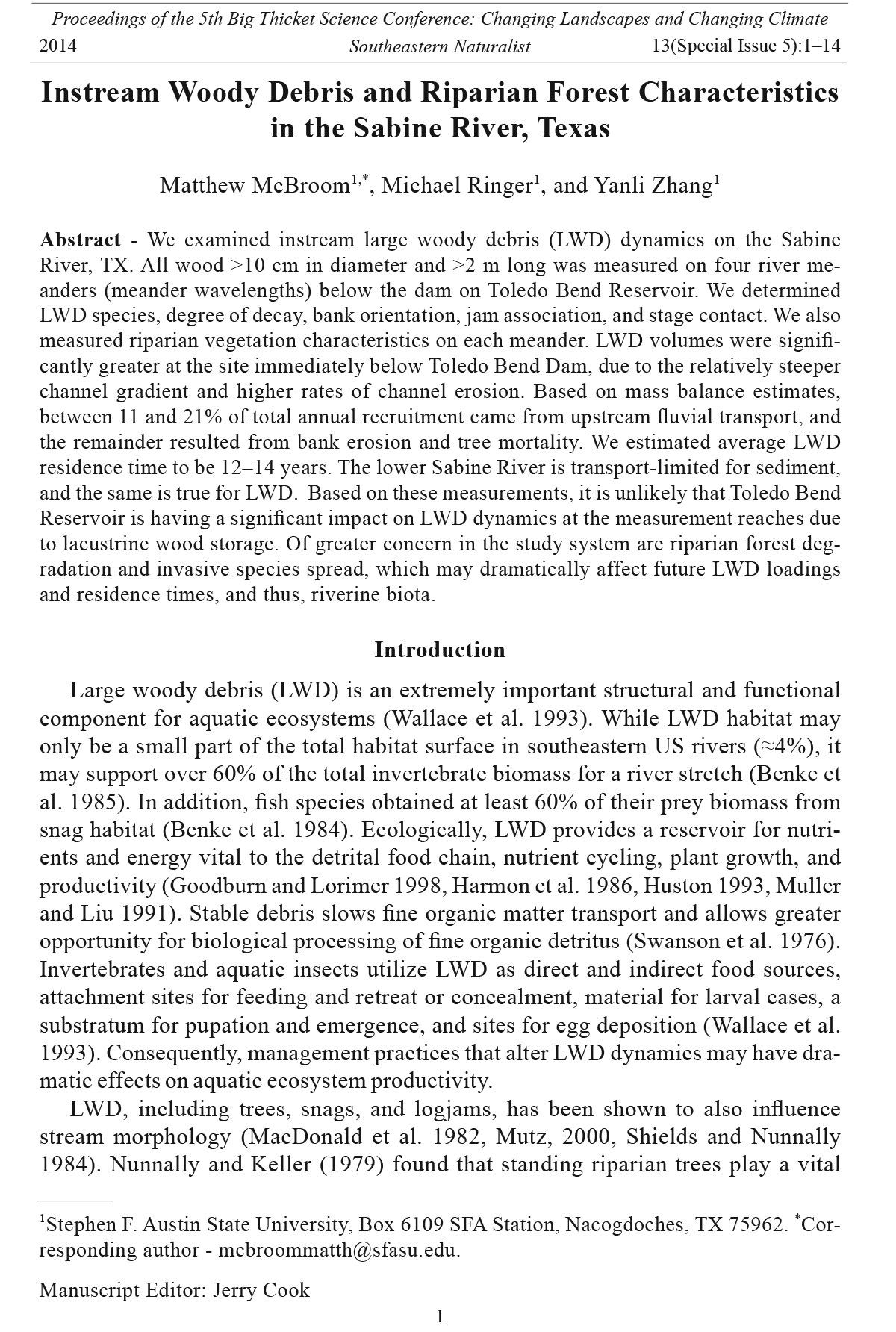
This study was conducted on the lower Sabine River downstream of Toledo
Bend Reservoir on the boundary between Texas and Louisiana (Fig. 1). The total
drainage area of the Sabine River is 25,267 km². Located in the Gulf Coastal Plain
physiographic province, the region has a humid subtropical climate (Phillips 2003).
The Sabine has the greatest total flow of any river in Texas, with average annual
Southeastern Naturalist
3
M. McBroom, M. Ringer, and Y. Zhang
2014 Vol. 13, Special Issue 5
flows ranging from 402 cms in 1975 to 30 cms in 2011, with an overall average
flow of 220 cms for the 1961–2011 period of record at the downstream-most US
Geological Survey (USGS) gauge at Deweyville, TX.
The soils surrounding the lower Sabine River were mostly light-colored, fine,
sandy loams with subsoils that were loamy sand to plastic clay in texture, and yellow
to red in color. The vegetation was mostly composed of a mixture of Pinus
taeda L. (Loblolly Pine) and various hardwoods like Quercus nigra L. (Water Oak),
Quercus phellos L. (Willow Oak), and Liquidambar styraciflua L. (Sweetgum). Wet
Figure 1. Sampling site locations for large woody debris measurements on the lower Sabine
River.
Southeastern Naturalist
M. McBroom, M. Ringer, and Y. Zhang
2014
4
Vol. 13, Special Issue 5
areas of the floodplain are dominated by Taxodium distichum L. (Baldcypress),
Salix nigra Marsh. (Black Willow), Betula nigra L. (River Birch), and the invasive
exotic Triadica sebifera (L.) Small (Chinese Tallow). Much of the surrounding land
had previously been cultivated and is now used for pasture or has been reforested,
either by natural seeding and resprouting or by planting.
We chose four meander wavelengths as study reaches that represented the upper,
middle, lower, and estuarine sections of the river. Three sites were located near
USGS river-gauging stations, and discharge data were obtained from these stations.
The Burkeville site (USGS 0802600) was northernmost and closest to the dam,
followed by Bon Wier (USGS 08028500), and Deweyville (USGS 08030500). We
measured sites once—during fall 2007 for Deweyville and summer 2008 for the
other three sites. Following Hurricane Rita in 2005, the Sabine River Authority of
Texas removed all bankside woody debris for a few river km above the southeast
Texas intake canal to prevent possible water supply disruptions to the region. Our
fourth site, denoted as the southern site, was located in the de-snagged zone, and
we used it to estimate the amount of time required for woody debris to return to
pre-snagging densities.
LWD measurement methods
To ensure that we had access to our sample sites, we measured instream LWD
during the lowest available river stages. Based on seasonal streamflow patterns
and hydropower release schedules from Toledo Bend Reservoir, we chose sample
dates when the river stage fell to a level low enough to allow access to a maximum
number of stems. Minimum LWD size was 10 cm in diameter and 2 m in length. We
measured log length and top butt diameter, and identified the logs to species when
possible. We determined relative degree of decay based on methods reported by
Hyatt and Naiman (2001) and used a scale from 1 to 5, where 1 meant that no sign
of decay was visible and all bark and branches were intact, and 5 indicated that the
bark was absent and the wood was irregularly shaped and was darkened.
We determined bank orientation using the following criteria: 0° meant that
the root wad was facing upstream and the LWD was parallel to the bank, a bank
orientation of 90° indicated that the log was perpendicular to the channel, and a
bank orientation of 180° indicated the LWD was facing downstream. In addition,
we noted the presence of a root wad and branches with a yes or no. We categorized
LWD origin as local riparian or upstream import and noted whether the LWD was
an individual piece, jam-associated, or a fallen tree. We defined a debris jam as
a discrete grouping of several pieces. Finally, we classified each LWD by stage
contact zone: zone 1 indicated that the piece was sitting in a low-flow contact area,
zone 2 indicated that it was within the bank-full channel, zone 3 indicated that it
extended over the bank-full channel, and zone 4 indicated that LWD was beyond
the bank-full channel.
Bankside vegetation data collection
We performed an inventory of the bankside vegetation at all four sites to determine
the total volume of standing timber. We established 0.04-ha and 0.004-ha
Southeastern Naturalist
5
M. McBroom, M. Ringer, and Y. Zhang
2014 Vol. 13, Special Issue 5
circular plots about 20 m from the bank on both the west and east banks at all four
sites. This distance was based on predictions by Robison and Beschta (1990) that
at least 50% of woody loading comes from within 15 m of the channel edge. In the
0.004-ha plots, we measured top and bottom diameters, length, and distance from
the bank for woody debris on the forest floor. In the 0.04-ha plots, we measured and
recorded diameter at breast height (DBH), total tree height, and distance from the
bank for all trees ≥10 cm DBH. We followed Clark and Souter (1996) to calculate
volumes using Girard Form Class 81 for pines and 79 for hardwoo ds.
Statistical analysis
For categorical data, we used chi-square tests to determine if a category was
uniformly distributed, i.e., the same number of individuals in each category.
We chose a uniform distribution because there were no a priori assumptions
about expected distributions. We used the chi-square tests (α = 0.05) available
in the statistical analysis system (SAS) version 9.2 (SAS Institute, Inc.
2008) to examine seven categories within the individual sites: degree of decay,
branch presence, origin, bank orientation, root-wad presence, position, and
stage contact. The null hypothesis in each case was that there was a uniform
LWD distribution in each category. We then developed contingency tables to
test these same seven categories between the sites. The null hypothesis was that
there was no association between each variable and the four sites. Finally, we
used an ANOVA with Tukey’s honest significant difference for multiple comparisons
to determine if there were significant differences between sites in riparian
forest density and instream LWD volumes.
Conceptual models of LWD dynamics
Benda and Sias (2003) developed functions that define wood recruitment into a
given study reach (Li):
Li = Im + If + Ibe + Is + Ie, (1)
where Im is the forest mortality, If is the toppling of trees after a fire or during a
windstorm, and Ibe is the recruitment due to bank erosion. They go on to define Is
as the wood brought into the system because of landslides, debris flows, and snow
avalanches, and Ie as the exhumation of buried wood. Benda and Sias (2003) further
developed a function that defines wood recruitment based on chronic forest
mortality only:
Im = [BLMHPm] N, (2)
where Im is the annual flux of LWD. They define BL as the volume of standing live
biomass per unit area, M as the rate of mortality, H as the average stand height, Pm
as the average fraction of stem length that becomes in-channel LWD, and N as the
number of banks contributing LWD.
One of the biggest contributors of LWD is bank erosion. In many regions, the
greatest amount of in-channel debris is found on the cutbank side of the river (Wallace
and Benke 1984), and that is one reason why the equation developed by Benda
Southeastern Naturalist
M. McBroom, M. Ringer, and Y. Zhang
2014
6
Vol. 13, Special Issue 5
and Sias (2003) for bank erosion is appropriate for the Sabine River. The function
used for LWD recruitment due to bank erosion is:
Ibe = [BLEPbe] N, (3)
where BL is the standing biomass, E is the mean bank erosion rate, and Pbe is the
expected stem length of the debris that falls into the channel.
We applied this model to the lower Sabine River with data collected in the current
study. For the four study reaches, we calculated the overall lateral recruitment
(Li). We converted the volume of live standing biomass (m3 ha-1) measured to m3
m-2, assumed a mortality rate of 1% based on relative mature forest age for the
dominant species present, and measured average stand heights. Number of contributing
banks was 2 for mortality input calculations, 1 for bank erosion. The proportion
of stem becoming biomass was 0.13 for mortality calculations, and 0.75 for
bank erosion. We assumed fall direction for mortality to be non-preferential, and
we chose a proportion of 0.13 based on long term averages compiled by Van Sickle
and Gregory (1990). Fall direction for bank erosion was based on values given in
Benda and Sias (2003). We derived estimates for mean bank-erosion rates of 0.1341
m yr-1for Burkeville, 0.10 m yr-1 for Bon Wier, and 0.05 m yr-1 for Deweyville and
the southern site based on Heitmuller and Greene (2009).
We then calculated the total woody debris budget from the basic relationship as
summarized by Benda and Sias (2003) as follows:
ΔSc = [Li - Lo + Qi / Δx - Qo / Δx - D] Δt, (4)
Where:
ΔSc = change in woody debris storage
Δx = reach length
Δt = time interval
Li = lateral recruitment of LWD within the reach
Lo = wood loss due to overbank depositions in flood events or the abandonment
of jams
Qi = fluvial transport of wood into the reach
Qo = transport of wood out of the reach
D = loss of wood due to decay
Results
LWD mass and volume
A total of 374 pieces of LWD were found, with 93, 95, 119, and 67 pieces at the
Burkeville, Bon Wier, Deweyville, and southern sites, respectively (Table 1). The
total volume of LWD was significantly greater at the Burkeville study site, immediately
below Toledo Bend Reservoir. LWD volumes were similar at sites further
downstream. Burkeville and the downstream sites had similar LWD counts (number
of stems), but because volume was much higher at Burkeville, we inferred that
piece size was larger there than at the other sites. Total bankside vegetation volume
was not significantly different among the four sites (Table 1).
Southeastern Naturalist
7
M. McBroom, M. Ringer, and Y. Zhang
2014 Vol. 13, Special Issue 5
LWD characteristics by site
Degree of decay was significantly different at each of the 4 sampling sites. Decay
class 3 was the most prevalent at Burkeville, Bon Wier, and Deweyville, while
significantly more LWD was found in decay class 4 at the southern site than at the
other three sites further upstream. Also, jam-associated LWD pieces were more
likely to be decayed at Burkeville, Deweyville, and the southern site. There was not
a statistically significant relationship between whether a piece was associated with a
jam and degree of decay at Bon Wier. In addition, decayed wood was more likely to
be in contact with low flows of the river at Burkeville, Deweyville, and the southern
site, while there was no relationship between decay and stage contact at Bon Wier.
LWD bank-position category was significantly different at the southern site and at
Bon Wier. At the southern site, half the LWD was located in jams.
Bank orientation was significantly different among sites. Pieces were more likely
to have a 0° orientation (root wad upstream, oriented with the flow) at Burkeville
and Bon Wier. However, at Deweyville and the southern site, orientation was more
likely to be 180°. Pieces were more likely to have intact root wads at Burkeville,
Bon Wier, and Deweyville, while LWD at the southern site was more likely to be
without a root wad. Root wads would tend to cause a 0° orientation with the flow,
which helps explain why pieces at the southern site have a greater frequency of 180°
orientations. However, when contingency tables were analyzed for root wad versus
orientation, no significant differences were found at any of the sites. As noted
above, pieces at the southern site were more decayed, and pieces with greater decay
are less likely to attach to a root wad.
In terms of stage contact, a significantly greater proportion of LWD was in the
low-flow contact zone or within the bank-full channel at all four sites, as opposed to
being beyond the bank-full channel. Pieces in the low-flow contact zone are subject
to greater mechanical battering and decay. In addition, very large floods would be
required to float and transport larger pieces (particularly if the root wad is still attached)
out of the bank-full channel.
Branches were more likely to be absent at Bon Wier and the southern site, but
frequencies were not significantly different at the other two sites. As expected,
when analyzing the contingency table for branch presence and degree of decay,
significant differences were found among categories, with more decayed pieces
lacking branches. We also conducted contingency-table analysis for bank position
Table 1. Total counts, volume, and ANOVA results (using Tukey’s honest significant difference) for
LWD and bankside vegetation for each study site along the lower Sabine River, TX. Mean values with
the same letter are not significantly different at α = 0.05
Bankside Tukey grouping
LWD LWD Reach Volume per volume for LWD for bankside
count volume (m3) length (km) length (m3/km) (m3 ha-1) volume vegetation
Burkeville 93 98.94 1.16 85.29 349.9 A A
Bon Wier 95 29.67 1.00 29.67 248.1 B A
Deweyville 119 49.43 1.06 49.63 407.1 B A
Southern 67 30.43 2.29 13.29 476.3 B A
Southeastern Naturalist
M. McBroom, M. Ringer, and Y. Zhang
2014
8
Vol. 13, Special Issue 5
versus branch presence, with frequencies found to be significantly different at all
four sites. In general, LWD lacking branches was more likely to be jam-associated,
and pieces with branches were typically more likely to occur singly or as bank-fall.
This finding is consistent with degree of decay and position as noted above.
The chi square goodness-of-fit test was also run on volume of LWD by origin.
In terms of total volume, frequency of origin was significantly different at all four
sites, with about 60–90% of the total volume originating from a local source. Larger
keystone pieces tended to be less decayed and less mobile, and accounted for more
of the overall volume at each site. All four study sites had large amounts of standing
vegetation, and most of the overall LWD volume originated from bankside sources.
LWD recruitment rates
The southern site was important to the study because all of the LWD had been
removed from the site three years prior to sampling, following Hurricane Rita. This
knowledge of a confirmed date at which there was no LWD present, enhanced our
ability to estimate the time required for LWD recruitment into the Sabine River.
When compared to the LWD counts at the other three sites, the southern site had
the least LWD within its reach, with 13.29 m3 km-1, about half that found at the next
lowest site, Bon Wier, with 29.67 m3 km-1(Table 1).
Based on our sampling, we estimated that about 12–14 years would be required
for LWD volume at the southern site to be equal what was observed at the Deweyville
site. This figure could change dramatically depending on the number and
size of catastrophic events (i.e., hurricanes and mass flooding) that impact the area
(Phillips and Park 2009).
Conceptual models of LWD dynamics
Lateral recruitment estimates illustrate differences between the four river segments
(Table 2). Burkeville, which has the highest total LWD loading (85.29 m3
km-1) also had the highest recruitment rate, and bank erosion was the primary
source for recruitment. At Deweyville and the southern sites, the riparian forest
volume was slightly higher with smaller tree sizes and much lower bank erosion
rates; mortality was the dominant recruitment source there.
We then compared these estimates of lateral recruitment with the overall woody
debris budget (Equation 4, above). To accomplish this, an estimate of woody debris
decay was needed. While specific estimates were not available, Spies et al. (1988)
estimated annual decay rates of between 2 and 7% of live biomass in a forest floor
Table 2. Lateral recruitment budget estimates (m3 km-1 yr-1) for the four study reaches on the Lower
Sabine River, TX (Benda and Sias 2003).
Mortality Bank erosion Total lateral
Site recruitment (Im) recruitment (Ibe) recruitment (Li)
Burkeville 1.40 3.52 4.92
Bon Wier 0.95 1.86 2.81
Deweyville 1.80 1.53 3.33
Southern 1.92 1.79 3.71
Southeastern Naturalist
9
M. McBroom, M. Ringer, and Y. Zhang
2014 Vol. 13, Special Issue 5
environment. Due to warm temperatures and high humidity, southeastern Texas has
one of the highest wood-decay rates in the continental United States (Harmon et al.
1986), so we used the higher end of this range, 7%, for budget calculations. With
a 7% decay rate, the average decay-based residence time for an average piece of
LWD is 14.29 years.
For the Burkeville and Deweyville sites, recruitment volume was a net positive,
meaning that fluvial transport of wood into the reach was occurring at a greater
rate than fluvial outflow. Recruitment volume was highest at Burkeville, which
was expected given the higher rates of bank erosion immediately downstream of
Toledo Bend Reservoir reported by Phillips (2003). This finding is consistent with
measured source data reported above and is also consistent with the lateral recruitment
estimates for Burkeville, where recruitment due to erosion is 2.5 times higher
than recruitment due to mortality (Table 3). It is unlikely that the Toledo Bend
Dam had a significant effect on reducing LWD loadings due to reservoir interruptions
of fluvial LWD at the Burkeville site. Additional measurements immediately
below the dam in the scour zone described by Phillips (2003) would be necessary
to determine if these LWD reservoir storage effects extend upstream of the Burkeville
site. At Deweyville, forest mortality recruitment is greater than bank-erosion
recruitment, due to the lower gradients at this site. Also, with lower gradients more
LWD accumulations from upstream may be occurring. At Bon Wier, we estimated
that more wood is being recruited than stored in the channel, so the loss may be due
to offsite transport (0.54 m3 km-1 yr-1) as fluvial outflow or floodplain deposition.
At the southern site, LWD accumulation had only occurred for about 3 years since
the post-Hurricane Rita de-snagging operation, with a lateral recruitment estimate
of 10.47 m3 km-1, meaning that the difference of 2.82 m3 km-1 may have come in as
fluvial inflow from further upstream.
Discussion
Total instream LWD volume was found to be significantly higher at Burkeville
(immediately below Toledo Bend Reservoir) than the other four sites likely due to
greater bankside erosion rates and geomorphologic differences between sites. This
result is supported by Phillips’ (2003) study of the lower Sabine River in which
Table 3. Estimated woody debris storage, decay, and recruitment by sampling site for the lower Sabine
River, TX.
Variable Burkeville Bon Wier Deweyville Southern
Total recruitment (Li, m3 km-1 yr-1) 4.92 2.81 3.33 3.71
Volume decayed (D, m3 km-1 yr-1) 0.34 0.20 0.23 0.22
Net recruitment (m3 km-1 yr-1) 4.58 2.61 3.10 3.49
Recruitment in 14.29 Yrs (m3 km-1) 69.29 37.29 44.29 49.86
Volume measured (m3 km-1) 85.29 29.67 49.63 13.29
(Qi - Qo - Lo) Vol. (m3 km-1 yr-1)A 1.05 -0.54 0.38 N/AB
AQi = LWD from fluvial inflow, Qo = LWD from fluvial outflow, Lo = floodplain deposition.
BEstimates are not available for the southern site since it was de-snagged 3 years prior to measurement.
Southeastern Naturalist
M. McBroom, M. Ringer, and Y. Zhang
2014
10
Vol. 13, Special Issue 5
he examined the effects of Toledo Bend Reservoir on the river downstream of the
dam. In that study, significant bank erosion, sandbar migration, and LWD inputs
at the Burkeville site were observed (Phillips 2003). The banks at Burkeville were
the steepest of the three study sites, and were heavily eroded, resulting in greater
LWD inputs than we observed at the other sites. Phillips (2003) reported that the
left bank was characterized by many fallen trees and bank-eroded trees, and that
overall, this section of the river was very dynamic, with many migrating sandbars
and higher rates of bank erosion. In contrast, lower rates of channel erosion were
reported near the Bon Wier section of the river (Phillips 2003). The Deweyville
site has a completely different form, with lower banks and fewer sandbars (Phillips
2003). The left bank at Deweyville had large amounts of LWD and numerous tilted
trees, and the right bank had former bank scarps with abundant LWD at the bank
base and in the channel. The LWD loadings observed in our study were similar to
those observed by Phillips (2003) (Table 1). Evaluating local geomorphic features
and understanding how river flow was affecting the banks at the local sites were the
best ways to explain the LWD loading differences.
The Burkeville site was characterized by active erosion and by larger diameter
trees standing closer to the channel, which explained the higher volumes of LWD.
Total LWD loading was best explained by the combination of bank erosion rates
and riparian forest structure.
In terms of number of pieces, frequency of LWD origin was significantly different
at Bon Wier and Deweyville. Wood at these two sites was more likely to be local
in origin. Origin frequencies were evenly distributed at the other two sites. Because
the Burkeville site is downstream of Toledo Bend Reservoir where banks are steep
and erosion is high, it would be expected that a greater number of wood pieces
would originate from stream bank erosion, with less relative upstream contribution.
This recruited wood would be deposited below the zone of influence immediately
below the dam, at the Burkeville site. At the southern site, more decayed wood
indicated more pieces being transported in from elsewhere.
The Burkeville and Deweyville sites had a uniform distribution for the position
category, meaning that the LWD present had an equal probability of being
associated with jams or present as individual pieces. At Bon Wier, a significantly
greater portion of LWD occurred as single pieces than as part of debris jams. Jamentrained
pieces were also significantly less likely to have intact branches. Large,
infrequent floods would be required to mobilize some of the jams that were found
on the Sabine, but as jam-entrained LWD decays and fragments over time, smaller
and more mobile decayed pieces move downstream to the southern site, where
about half of the LWD was located in jams. However, these smaller pieces represent
a lower overall contribution to total LWD volume than a comparable number
of larger pieces.
Because we found no significant differences in total bankside volume among
sites, we conclude that recent hurricanes have not resulted in significant overall
reduction in quantity of riparian forest vegetation at the sites close to the Gulf
Coast. This lack of statistical significance can be attributed in part to the large
Southeastern Naturalist
11
M. McBroom, M. Ringer, and Y. Zhang
2014 Vol. 13, Special Issue 5
amount of variation observed among individual plots in each stand. Riverside
forest vegetation volumes tend to be rather heterogeneous overall, with much
higher volumes on the cut-bank side of the meander than on the deposition side.
However, there was a great deal of variation within meander wavelengths, and
additional vegetation sampling would be needed to make specific determinations
about effects on riparian forest structure and composition along the Sabine River.
Also, Hurricane Rita, which made landfall at the Sabine estuary on 24 September
2005 resulted in a significant increase in L WD contributions to the river (Phillips
and Park 2009).
The northernmost Burkeville site had larger trees overall compared to the more
downstream sites. In particular, the invasive exotic Chinese Tallow Tree tended to
be much more prevalent at the southern and Deweyville sites than at the two sites
further upstream. This would be expected given this tree’s ability to dominate the
wet conditions characteristic of these two sites. Also, given the high seed production
rate, high primary productivity, and extensive colonization of the lower Gulf
Coastal Plain of Texas, continued domination of this species in the riparian forest
is likely at these two sites (Bruce et al. 1995).
LWD budget estimates are a reasonable approximation of LWD dynamics in
the lower Sabine River. One significant conclusion from this budget analysis is
that the riparian forest density and volume are the most important factors for LWD
recruitment. Fluvial transport into the reach was estimated to be between 11 and
21% of total annual recruitment, with the remainder governed by lateral recruitment,
which depends mostly on surrounding forest density and bankside erosion
rates. These estimates are consistent with recruitment rates measured upstream.
Therefore, the most effective means of enhancing LWD recruitment for the lower
Sabine would be to protect and enhance the riparian forest. There does not seem to
be much evidence from this analysis that the Toledo Bend Dam had a significant impact
on LWD dynamics in the lower Sabine River due to upstream LWD storage in
the reservoir. As noted by Phillips (2003), the lower Sabine is transport-limited for
sediment, and the same is true for LWD. It is likely that the large volumes of LWD
that were historically in the rivers of East Texas were the products of extensive,
more contiguous riparian forests composed of relatively decay-resistant species
like cypress and oak, and that centuries of riparian forest degradation and spread of
less decay-resistant and invasive species like Chinese Tallow has resulted in lower
maximum potential LWD loadings.
A majority of LWD research has been conducted in higher-gradient streams,
where fluvial export is an important factor controlling LWD dynamics. Very little
research has been conducted on low-gradient Coastal Plain streams in the Southeast.
One exception to this is a study by Beneke and Wallace (1990) in the Ogeechee
River in the Coastal Plain of Georgia, in which they found that decomposition and
fragmentation of LWD is the most common fate for LWD rather than direct fluvial
export. We reached a similar conclusion for the lower Sabine River, TX in this
study. In addition, as concluded by Beneke and Wallace (1990) for the Ogeechee
River, as the larger, more stable, and persistent LWD pieces in the lower Sabine
Southeastern Naturalist
M. McBroom, M. Ringer, and Y. Zhang
2014
12
Vol. 13, Special Issue 5
break down over decades, they will provide an important source of organic matter
and habitat for aquatic organisms. Additional studies are needed to determine the
optimal LWD loading for riverine invertebrate and fish populations in the lower
Sabine. Additional research is also needed on LWD loading and dynamics on other
southeastern lower Coastal Plain rivers.
Acknowledgments
This study was funded by the Texas Water Development Board. The assistance of Mark
Wentzel and Greg Malstaff is greatly appreciated. The Sabine River Authority of Texas
provided invaluable information, river transportation, and much assistance to this project.
Special thanks go to Luke Sanders, Brian King, John Payne, Jamie East, Jerry Wiegreffe,
and Elizebeth Loomis. Assistance and support was also provided by the Waters of East
Texas (WET) Center at the Arthur Temple College of Forestry and Agriculture at Stephen
F. Austin State University.
Literature Cited
Abbe, T.B., A.P. Brooks, and D.R. Montgomery. 2003. Wood in river rehabilitation and
management. Pp. 367-389, In S.V. Gregory, K.L. Boyer, and A.M. Gurnell (Eds.). The
Ecology and Management of Wood in World Rivers. American Fisheries Society Symposium
37, Bethesda, MD
Benda, L.E., and J.C. Sias. 2003. A quantitative framework for evaluating the mass balance
of in-stream organic debris. Forest Ecology and Management 172:1–16.
Benke, A.C., and J.B. Wallace. 1990. Wood dynamics in coastal plain Blackwater Streams.
Canadian Journal of Fisheries and Aquatic Science 47:92–99.
Benke, A.C., R.L. Henry III, D.M. Gillespie, and R.J. Hunter. 1985. Importance of snag
habitat for animal production in southeastern streams. Fisheries 10(5):8–13.
Bilby, R.E. 1984. Post-logging removal of woody debris affects stream channel stability.
Journal of Forestry 82:609–613.
Bruce, K.A., G.N. Cameron, and P.A. Harcombe. 1995. Initiation of a new woodland type
on the Texas coastal prairie by the Chinese Tallow tree (Sapium sebiferum (L.) Roxb.).
Bulletin of the Torrey Botanical Club 122:215–225.
Clark, A. III, and R.A. Souter. 1996. Stem cubic-foot volume tables for tree species in the
Deep South Area. Research Papr SE-293. US Department of Agriculture Forest Service,
Southern Research Station, Asheville, NC. 131 pp.
Goodburn, J.M., and C.G. Lorimer. 1998. Cavity trees and coarse woody debris in oldgrowth
and managed northern hardwood forests in Wisconsin and Michigan. Canadian
Journal of Forest Research 29:427–438.
Harmon, M.E., J.F. Franklin, F.J. Swanson, P. Collins, S.V. Gregory, J.D. Lattin, N.H.
Anderson, S.P. Cline, N.G. Aumen, J.R. Sedell, G.W. Lienkaemper, K. Cromack, Jr.,
and K.W. Cummins. 1986. Ecology of coarse woody debris in temperate ecosystems.
Advances in Ecological Research 15:133–302.
Heitmuller, F.R., and L.E. Greene. 2009. Historic channel adjustment and estimates of
selected hydraulic values in the lower Sabine River and Lower Brazos River Basins,
Texas and Louisiana. US Geological Survey Scientific Investigations Report 2009-5174.
Washington, DC. 143 pp.
Southeastern Naturalist
13
M. McBroom, M. Ringer, and Y. Zhang
2014 Vol. 13, Special Issue 5
Huston, M.A. 1993. Models and management implications of coarse woody debris impacts
on biodiversity. Pp. 139–143, In J.W. McMinn and D.A. Crossley, Jr. (Eds.). Biodiversity
and coarse woody debris in southern forests, proceedings of the workshop on coarse
woody debris in southern forests: Effects on biodiversity. USDA Forest Service Gen.
Tech. Rep. SE-94. Asheville, NC.
Hyatt, T.L., and R.J. Naiman. 2001. The residence time of large woody debris in the Queets
River, Washington, USA. Ecological Applications 11:191–202.
Keller, E.A., and F.J. Swanson. 1979. Effects of large organic material on channel form and
fluvial processes. Earth Surface Processes. 4:361–380.
Keller, E.A., and T. Tally. 1979. Effects of large organic debris on channel form and fluvial
processes in the costal redwood environment. Pp. 169–197, In D.D. Rhodes and P.G.
Williams (Eds.). Adjustment of the Fluvial System. Proceedings of the Tenth Annual
Geomorphology Symposium.. State University of New York, Binghamton, NY.
MacDonald, A., E.A. Keller, and T. Talley. 1982. The role of large organic debris in stream
channels draining Redwood forests in northwestern California. Pp. 226–245, In D.K.
Harden, D.C. Marran, and A. MacDonald (Eds.). Late Cenzoic History and Forest Geomorphology
of Humbold County, California. Friends of the Pleistocene, Pacific Cell
Field Trip Guidebook, San Fransisco, CA.
Muller, R.N., and Y. Liu. 1991. Coarse woody debris in old-growth deciduous forest on
the Cumberland Plateau, Southeastern Kentucky. Canadian Journal of Forest Research
21:1567–1572.
Mutz, M. 2000. Influences of woody debris on flow patterns and channel morphology
in a low-energy, sand-bed stream reach. International Review of Hydrobiology
85(1):107–121.
Nunnally, N.R. 1978. Stream renovation: An alternative to channelization. Environmental
Management 2(5):403–410.
Nunnally, N.R., and E. Keller. 1979. Use of fluvial processes to minimize adverse effects
on stream channelization. Report No. 144, Water Resources Research Institute of the
University of North Carolina, Raleigh, N.C.
Phillips, J.D. 2003. Toledo Bend Reservoir and geomorphic response in the lower Sabine
River. River Resources Applications 19:137–159.
Phillips, J.D., and L. Park. 2009. Forest-blown impacts of Hurricane Rita on fluvial systems.
Earth Surface Processes and Landforms 34:1069–1081.
Robison, E.G., and R.L. Beschta. 1990. Coarse woody debris and channel morphology interactions
for undisturbed streams in southeast Alaska. US Earth Surface Processes and
Landforms 15:149–156.
SAS Institute, Inc. 2008. Version 9.2 Cary, NC
Shields, F.D., and C.J. Gippel. 1995. Prediction of effects of woody debris removal on flow
resistance. Journal of Hydrologic Engineering 121:341–354.
Shields, F.D., and N.R. Nunnally. 1984. Environmental aspects of clearing and snagging.
Journal of Environmental Engineering 110(1):152–154.
Smith, R.D., R.C. Sidle, P.E. Porter, and J.R. Noel. 1993. Effects of experimental removal
of woody debris on the channel morphology of a forest, gravel-bed stream. Journal of
Hydrology 152:153–178.
Spies, T.A., J.F. Franklin, and T.B. Thomas. 1988. Coarse woody debris in Douglas-fir forests
of western Oregon and Washington. Ecology 696:1689–1702.
Southeastern Naturalist
M. McBroom, M. Ringer, and Y. Zhang
2014
14
Vol. 13, Special Issue 5
Swanson, F.J., G.W. Lienkaemper, and J.R. Sedell. 1976. History, physical effects, and
management implications of large organic debris in western Oregon streams. Pacific
Northwest Forest and Range Experiment Station US Department of Agriculture, Portland,
OR.
Trimble, S.W. 1997. Stream-channel erosion and change resulting from riparian forests.
Geology 25:467–469.
Van Sickle, J., S.V. Gregory. 1990. Modeling inputs of large woody debris to streams from
falling trees. Canadian Journal of Forest Research 20:1593–1601.
Wallace, J.B., and A.C. Benke. 1984. Quantification of wood habitat in subtropical Coastal
Plain streams. Canadian Journal of Fisheries and Aquatic Sciences. 41:1643–1652.
Wallace, J.B., J.W. Grubaugh, and M.R. Wiles. 1993. Influences of coarse woody debris on
stream habitats and invertebrate biodiversity. Pp. 119–129, In J.W. McMinn, and D.A.
Crossley, Jr. (Eds.). Biodiversity and Coarse Woody Debris in Southern Streams: Proceedings
of the Workshop on Coarse Woody Debris in Southern Forests: Effects on Biodiversity.
Athens, GA, USDA Forest Service Southern Research Station, Asheville, NC.


 The Southeastern Naturalist is a peer-reviewed journal that covers all aspects of natural history within the southeastern United States. We welcome research articles, summary review papers, and observational notes.