Southeastern Naturalist
D.A. Scott
2014
64
Vol. 13, Special Issue 5
Initial Ecosystem Restoration in the Highly Erodible
Kisatchie Sandstone Hills
D. Andrew Scott*
Abstract - Restoration of the unique and diverse habitats of the Kisatchie Sandstone Hills
requires the re-introduction of fire to reduce fuel accumulation and promote herbaceous
vegetation, but some soils in the area are extremely erodible, and past fires have resulted
in high erosion rates. Overstory and understory vegetation, downed woody fuels, and
other stand attributes were measured on sites that received either no management or two
prescribed burns after >20 years of fire exclusion. The two burns (one dormant season
and one growing season) reduced the live fuel-load (understory biomass) and forest floor
(litter and duff mass) by 90 and 71%, respectively, but did not change the downed woody
fuel load. Understory plant diversity was not affected by burning, but burning stimulated
both colonization and sprouting for most plant species. Habitat for Picoides borealis
(Red-cockaded Woodpecker) was improved; understory plant height was reduced by 2 m,
and herbaceous vegetation was found in 40% of the areas sampled in the burned sites but
it was found in only 6.7% of the reference (unburned) sites. Erosion risk was still elevated
due to the sparse vegetative cover on the forest floor. Future management should consider
erosion prevention, and plan the timing and intensity of additional burns to maximize
plant cover on the forest floor and to improve the habitat by converting the woody understory
to an herbaceous understory.
Introduction
The Kisatchie Sandstone Hills is a unique and diverse landform in west-central
Louisiana that supports a number of fire-dependent ecosystems, but management of
this area is confounded by the area’s highly erosive soils and low inherent productivity.
The region has a long management history, and past practices have degraded
the ecosystem and pursued priorities and goals different from those of today’s
land managers. Because the soils are sensitive to management actions, including
mechanical impacts and prescribed fire, ecosystem restoration will require careful
adaptive management that incorporates research and monitoring to produce the
conditions necessary for all ecosystem functions and services.
A century of timber harvest and fire suppression in the Pinus palustris (Longleaf
Pine) forests in the West Gulf coastal plain, including the Kisatchie Hills, has
resulted in massive ecosystem changes. Many unique habitats have been degraded,
and changes in plant and animal species composition have been widespread (Van
Lear et al. 2005). Many species characteristic of fire-maintained pine forests have
become endangered or rare due to changes in the fire regime (Phillips and Hall
2000, Rudolph and Burgdorf 1997). The Kisatchie Hills area is home to several
*USDA Forest Service, Southern Research Station, PO Box 1927, Normal, AL 35762;
andyscott@fs.fed.us.
Manuscript Editor: Jerry Cook
Proceedings of the 5th Big Thicket Science Conference: Changing Landscapes and Changing Climate
2014 Southeastern Naturalist 13(Special Issue 5):64–79
Southeastern Naturalist
65
D.A. Scott
2014 Vol. 13, Special Issue 5
sensitive terrestrial and aquatic habitats for both flora and fauna (Van Kley 1999).
Hillside bogs, sandstone glades and barrens, and sandy woodlands are all found in
relative abundance in the Kisatchie Hills.
This area represents some of the best potential habitat for the endangered Picoides
borealis Vieillot (Red-cockaded Woodpecker) (RCW), and rare Pituophis ruthveni
Stull (Louisiana Pine Snake) (LPS) (Kisatchie National Forest Staff 1999a).
Past management for timber production and open-range cattle grazing included fire
suppression, which allowed woody fuels to accumulate and reduce habitat quality
for RCW, LPS, and other open woodland animals. The management goal is restoration
of the type of open-canopied woodland with an understory dominated by
diverse herbaceous and low woody species that would provide excellent habitat for
several target wildlife species including RCW and LPS (Kisatchie National Forest
Staff 1999b). The Kisatchie National Forest plans to use prescribed fire to restore
this natural community.
The fire return interval in the Kisatchie Hills was 2.1 yrs from the 1600s until
the mid-1900s, and included both dormant and growing-season burns (Stambaugh
et al. 2011). Dormant-season burns are commonly prescribed to reduce downed
woody and forest floor fuels, but generally have little effect on woody vegetation.
Growing-season burns, while difficult to manage under heavy fuel conditions, are
more effective at controlling recruitment and sprouting of woody species (Drewa
et al. 2002, 2006). Erosion losses are likely to be greatest following removal of the
soil cover by fire, resulting in exposure of mineral soil (Larse n et al. 2009).
Soils on the study site are both quite infertile and highly erodible. The
Kisatchie soil series is of specific interest due to its prominence in the area and its
erosivity. It is widely mapped in an eroded phase, where the original Bt horizon
has become the surface layer. This soil is a very slowly permeable, smectitic soil
with a low Ca:Mg ratio, which increases clay dispersion, reduces soil structural
stability, and increases erosivity (Dontsova and Norton 2002). Runoff is high on
areas with steep slopes, and the dispersing nature of the soil and lack of soil cover
due to infertility creates conditions resulting in extensive particle displacement.
Wildfire-induced soil erosion is well-documented in the western US, (Larsen et
al. 2009), whereas it is rarely recognized as a severe problem in the southeastern
US (Callaham et al. 2012). However, many of the same conditions observed in
forests of the western US are present in the Kisatchie Hills area: i.e., impaired hydrology,
steep topography, and slow plant growth. Schoelerman (1981) measured
soil loss for 15 months following a single prescribed fire on Kisatchie soils after
20 years of fuel accumulation, and found twice as much loss in burned areas as on
unburned areas.
The objectives of this study were to 1) determine the effectiveness of the
initial reintroduction of prescribed fire using a combined dormant and growing
season fire regime for hazardous fuels reduction and habitat restoration goals,
and 2) assess the soil condition following two prescribed burns and the potential
for subsequent soil loss.
Southeastern Naturalist
D.A. Scott
2014
66
Vol. 13, Special Issue 5
Methods
The study was conducted on the Kisatchie Ranger District near Gorum, LA
(31.46°N, 93.005°W; Fig. 1). The climate is humid subtropical with a mean annual
temperature of 19.4 °C and 1270 mm of precipitation, which is relatively evenly
distributed throughout the year (Soil Conservation Service 1990). No forestry operations
had been conducted on the 1600-ha area for 60–70 yrs and no extensive
burns (wildfire or prescribed) had occurred in at least 20 years. Cattle grazing may
have occurred in the area, but not for at least 20 years.
Reintroduction of prescribed fire was initiated in 2004; a dormant-season burn
was conducted in January on about half the overall study area to reduce fuel loading,
and a growing-season fire was conducted in May 2007 to further control fuel
loading and to control woody shrubs and understory trees. The remaining area
was not burned. In 2009, we selected five sites ranging from about 10 ha to over
30 ha in the burned and unburned areas (Fig. 2). We based site selection on dominant
species, condition class, stand age, soil series, and topography, with a focus
on pine-dominated, mature (>50 yrs old) sites on Kisatchie-series or Kisatchie-
Figure 1. Kisatchie National Forest boundary and the Kisatchie Sandstone Hills land type
area in LA.
Southeastern Naturalist
67
D.A. Scott
2014 Vol. 13, Special Issue 5
dominated soil associations with moderate topography. Mature forests were selected
to reduce inherent variability.
Figure 2. Burned and non-burned (reference) sites in the Kisatchie Hills area near Gorum, LA.
Southeastern Naturalist
D.A. Scott
2014
68
Vol. 13, Special Issue 5
Within each site, six sampling points were arrayed on an 81-m x 161-m, randomly
applied rectangular grid. Overstory vegetation, i.e., trees in dominant or
codominant canopy positions, was tallied by species and sampled using variableradius
plot sampling with a 2.29-m2 ha-1-factor wedge prism. We used a laser
hypsometer to measure height and height to the base of the live crown on a 20%
random sample of all dominant and codominant trees, and we calculated live-crown
ratio as the length of the crown (base of crown to top of the tree) to the total tree
height. We measured diameter at breast height (DBH) and determined tree age with
an increment borer. Species, total height (or length if not erect), and the number of
stems per rootstock were tallied for all midstory and understory woody plants. We
tallied individual plants >1.37 m tall within a 61.4-m2 plot, and individuals <1.37 m
tall within a 5.91-m2 plot. Biomass (oven-dry equivalent) was calculated using
equations developed for similar species and used to estimate live fuel loadings
(Scott et al. 2006). Horizontal vegetation density at 2 m height, a habitat indicator
for RCW (Rudolph et al. 2002), was determined at 15 m from the center point at
0°, 90°, 180°, and 270° from the transect azimuth (not cardinal directions) using a
50- x 50-cm density board with 10- x 10-cm squares. Woody plant diversity in the
understory was calculated with Shannon’s index (Shannon 1948).
At each sampling point, we established a 15.25-m transect from the sample
center point in a random azimuth as determined by a random number generator.
We measured forest-floor thickness to the interface with mineral soil, to the
nearest 1 cm at 10 points along this transect (0.3, 1.5, 3.0, 4.6, 6.1, 7.6, 9.1, 10.7,
12.2, 13.7, 15.2 m, respectively). We determined forest-floor and herbaceous
plant mass by sampling floor material within a 25-cm x 25-cm frame at 1.52,
7.62, and 13.7 m along the transect. Samples were dried at 70 oC to a constant
water content before weighing. At each of these three points, we measured the
percent cover of herbaceous plants. Downed woody debris intercepts were noted
for the 1- and 10-hour fuels within the first 1.83 m of the transect, the 100-hr fuel
intercepts were documented within the first 3.66 m, and the 1000-hr fuels were
recorded along the entire 15.25-m transect (Brown 1974).
We calculated means of multiple observations per site, and used univariate tests
of normality to determine if transformations were needed to improve normality
or variance homogeneity. Site-level means and standard errors are reported (n = 5
sites per treatment). Treatment differences were determined by t-test and considered
significant at P < 0.10 (SAS Institute, Inc. 2004). The false discovery rate was
controlled with the Benjamini-Hochberg method (Benjamini and Hochberg 1995).
Results and Discussion
The responses of primary interest were woody vegetative composition and
height, total fuel loading, herbaceous community recovery, and soil cover. These
variables are important for several interrelated reasons in an ecosystem management
context. First, the total fuel-loading, especially tall ladder-fuel (senesced
needles and dead woody debris), is of concern because it can indicate the potential
damage that an uncontrolled wildfire could cause to the forest, soil, and watershed
Southeastern Naturalist
69
D.A. Scott
2014 Vol. 13, Special Issue 5
conditions. As fuel loads increase, the potential for uncontrolled wildfire to have
severe fire effects, such as overstory tree mortality and severe erosion, increases.
Erosion can lead to increased sediment delivery to streams, changes in hydrologic
function, and soil loss and decreased site quality (Neary et al. 2008). Secondly, the
understory vegetation structure is an important determinant of habitat quality for
the endangered RCW and other significant wildlife. The restoration of herbaceous
understory vegetation was a desired outcome of the study’s treatments because its
presence increases habitat integrity and value for a number of organisms in addition
to the RCW (Rudolph and Burgdorf 1997). Finally, while prescribed fire will reduce
fuel loading and increase the desired herbaceous understory, soil cover is needed to
protect the area’s erodible soils from rainfall impacts and to reduce runoff so that
water infiltration is maintained. On many sites with Kisatchie soils, the coarsertextured
topsoil has already eroded, leaving a relatively impermeable, fine-textured
soil that is prone to runoff and further erosion unless it is covered by forest floor or
herbaceous vegetation.
General stand characteristics
Sites were chosen that were similar with respect to landform, soil type, and
slope. All sites were located on Miocene-aged sediments of the Catahoula
and Fleming formations and included Kisatchie series (fine, smectitic, thermic
Typic Hapludalf) or Kisatchie-Oula (fine, smectitic, thermic Vertic Hapludalf)
complex. The topography of the sites was qualitatively quite similar; we did not
observe differences in the general character of the sites. The mean slopes were
similar (19% for reference sites and 13% for burned sites; Table 1). The measurement
points occurred in all slope positions (ridge, midslope, toeslope) in both
reference and burned sites.
Vegetative composition and habitat value
The overstory vegetation was very similar across both treatments (Table 1).
Overstory tree age, as measured on dominant or codominant trees within a measurement
point, averaged just over 63 years for both treatments, indicating that the
even-aged stands originated in the mid-1940s. The specific mechanism of stand
establishment is unknown, but likely included a mix of natural regeneration, direct
seeding, and possibly some planting, although no rows were apparent. The mean
arithmetic DBH and height of the dominant or codominant pines were similar and
averaged about 38 cm and 23 m, respectively, across the treatments. The live crown
and live-crown ratio were not different between treatments. Pine, hardwood, and
total stand basal area were similar across treatments and averaged 16.5, 4.2, and
20.7 m2 ha-1, respectively. The basal area in standing dead trees was also similar
between the treatments. The overstory was primarily composed of Pinus taeda
(Loblolly Pine) or Longleaf Pine, but one site contained over 50% Pinus echinata
(Shortleaf Pine), and nearly every site included all three pine species. Longleaf Pine
was a more common dominant species on the burned sites (Table 2), and Loblolly
Pine more commonly dominated the unburned reference sites, but these differences
Southeastern Naturalist
D.A. Scott
2014
70
Vol. 13, Special Issue 5
likely resulted from historical regeneration patterns rather than recent treatments.
Quercus marilandica (Blackjack Oak) and Quercus stellata (Post Oak) were the
predominant hardwood trees in the overstory; a variety of other oaks and hardwoods
were also documented (Table 2).
We observed differences in the structure of the midstory and understory strata
between the reference and burned sites. The understory plant density (plants ha-1)
was 79% greater in the burned sites, and the total stem density was more than 3-fold
greater in the burned sites than in the unburned reference sites (Table 1). Over
Table 1. General site characteristics of reference and burned sites on highly erodible soils in the
Kisatchie Hills area of LA.
Reference Burned
Site characteristic Mean SE Mean SE PB
Slope (%) 18.7 3.3 13.1 1.3 0.1525
Age (yrs) 63.2 5.5 63.8 3.9 0.9646C
DBHA (cm) 36.2 2.3 39.5 1.8 0.1576C
HeightA (m) 22.8 0.8 24.3 0.7 0.2119
Height to live crownA (m) 12.9 0.6 14.8 0.7 0.0778
Live-crown ratioA 0.44 0.00 0.39 0.00 0.2162
Total basal area (m2) 20.0 1.8 21.3 1.2 0.5884
Pine basal area (m2) 14.8 1.7 18.1 2.2 0.2756
Hardwood basal area (m2) 5.2 1.2 3.1 1.6 0.3390
Snag basal area (m2) 0.2 0.6 0.9 0.2 0.3042D
Horizontal density at 2 m (%)E 89.6 3.7 17.6 9.7 0.0001
Understory density (plants ha-1) 16,269 3750 29,087 1673 0.0142
Understory density (stems ha-1) 26,162 6200 78,600 14,291 0.0098
Understory >1.37 m (stems ha-1) 9072 1310 2232 661 0.0016
Understory diversity (woody)F 2.83 0.19 2.35 0.19 0.1480
Understory height (m) 3.03 0.13 0.84 0.06 <0.0001
Understory biomass (Mg ha-1) 11.17 1.86 1.13 0.14 <0.0001
Downed fuel (1 hr) (Mg ha-1) 0.06 0.01 0.06 0.03 0.9090
Downed fuel (10 hr) (Mg ha-1) 0.74 0.14 0.79 0.17 0.8226
Downed fuel (100 hr) (Mg ha-1) 1.59 1.23 2.61 0.74 0.4985
Downed fuel (1000 hr) (Mg ha-1) 5.86 2.92 5.85 1.61 0.9974
Downed fuel (total) (Mg ha-1) 8.25 2.87 9.31 1.95 0.7681
Forest-floor depth (cm) 5.98 0.52 2.67 0.34 0.0007
Forest-floor mass (Mg ha-1) 24.3 2.0 7.0 0.2 0.0009D
Forest-floor density (kg m-3) 41.4 2.0 28.3 2.3 0.0026
ADBH, height, and crown height and ratio were measured on 20% of the dominant or codominant pine
trees in each plot, not all trees.
BP-values from pooled t-test unless noted. Comparisons with P > 0.04 were not rejected at alpha of
0.10 following control of Type I error with the Benjamini-Hochberg false discovery rate (Benjamini
and Hochberg 1995).
CAge and DBH were transformed as log (DBH) to meet normality.
DP value from t-test with unequal variances (Satterthwaite).
E50-cm x 50-cm density-board read at 2 m height,15.24 m from plot center point.
FWoody plant species diversity calculated from Shannon’s index.
Southeastern Naturalist
71
D.A. Scott
2014 Vol. 13, Special Issue 5
28 species were recorded in the woody understory vegetation, but analysis with
Shannon’s index did not detect differences in woody plant diversity (Table 1). Ilex
vomitoria (Yaupon) was the dominant understory species, followed by a number of
Vaccinium spp. (blueberries), Morella cerifera (Wax Myrtle), and Crataegus spp.
(hawthorns) (Table 3). While a few species were less abundant in the burned sites
than in the reference sites, the only commonly found species with less abundance
in the burned sites were hawthorns. Hawthorns averaged 617 plants ha-1 (825 total
stems ha-1) in the reference sites but only 169 plants ha-1 (225 stems ha-1) in the
burned sites. Otherwise, both the number of individual plants and the total number
of stems were substantially greater for most species in the burned sites (Table 3,
Fig. 3). Yaupon was especially prevalent in the burned sites, which had over 6000
more Yaupon plants ha-1 (35,000 total stems ha-1) than the reference sites. Most
species were not only more abundant in the burned sites, likely due to post-burn
recruitment, but the number of stems per plant increased as well (Fig. 3). A few
species had the same number of stems per plant regardless of treatment, but others,
especially Acer rubrum (Red Maple), Blackjack Oak, Quercus alba (White
Oak), and Yaupon, had 2- to 3-fold more stems per plant in the burned sites as in
the reference sites. This increase in stem density was expected because repeated
growing-season burns are generally required to reduce the sprouting ability of the
understory shrubs in the area (Drewa et al. 2002). Horizontal density at 2 m was
90% in the reference sites but only 18% in the burned sites (Table 1). The stem
density of understory plants greater than 1.37 m tall was more than 4-fold higher in
the reference sites than in the burned sites. The understory averaged >3 m tall in the
reference sites, and several species, e.g., Red Maple and Loblolly Pine, averaged
4 m tall (Fig. 4). The mean understory plant height was more than 2 m less in the
burned sites compared to the reference sites (Table 1), and almost all species were
Table 2. Overstory basal area (m2 ha-1) by species in reference and burned sites on highly erodible
soils in the Kisatchie Hills area of LA (n = 5 stands per treatment). Standard errors are in parentheses.
Species Reference Burned P-value A
Pinus taeda L. (Loblolly Pine) 6.27 (2.39) 7.58 (2.45) 0.7139
P. palustris Mill. (Longleaf Pine) 11.30 (3.79) 4.59 (2.35) 0.1696
P. echinata Mill. (Shortleaf Pine) 0.54 (0.29) 2.68 (2.15) 0.3775B
Quercus marilandica Münchh. (Blackjack Oak) 0.77 (0.48) 1.22 (0.41) 0.4891
Q. stellata Wangenh. (Post Oak) 0.69 (0.46) 1.45 (0.49) 0.2874
Q. falcata Michx. (Southern Red Oak) 0.46 (0.22) 0.61 (0.61) 0.8202
Q. alba L. (White Oak) 0.15 (0.15) 0.38 (0.21) 0.4021
Q. nigra L. (Water Oak) 0.00 (0.00) 0.08 (0.08) 0.3739B
Liquidambar styraciflua L. (Sweetgum) 0.84 (0.33) 0.38 (0.24) 0.2936
Acer rubrum L. (Red Maple) 0.08 (0.08) 0.38 (0.24) 0.2839B
Carya alba (L.) Nutt. (Mockernut Hickory) 0.00 (0.00) 0.54 (0.45) 0.2962B
Nyssa sylvatica Marsh. (Black Gum) 0.00 (0.00) 0.15 (0.15) 0.3739B
Ulmus americana L. (American Elm) 0.08 (0.08) 0.00 (0.00) 0.3739B
Fraxinus pennsylvanica Marsh. (Green Ash) 0.08 (0.08) 0.00 (0.00) 0.3739B
AP-values from pooled t-test unless noted.
BP-value from t-test with unequal variances (Satterthwaite).
Southeastern Naturalist
D.A. Scott
2014
72
Vol. 13, Special Issue 5
shorter on the burned plots (Fig. 4) than on the unburned plots. Herbaceous cover
was distinctly greater in the burned sites compared to the reference sites (Table 4).
These changes in vegetative composition and structure had several positive effects
on habitat quality for the endangered RCW and other wildlife. The Kisatchie
Hills support high quality habitat for the RCW, Geomys breviceps Baird (Baird’s
Pocket Gopher), and LPS. Although not listed as threatened or endangered, LPS
is very rare (Rudolph and Burgdorf 1997; Rudolph et al. 2006). Red-cockaded
Woodpeckers require old, widely spaced dominant and codominant canopy pines
for cavity excavation, and open pine habitat with a limited midstory for foraging.
Baird’s Pocket Gophers feed on the belowground portions of herbaceous plants
(English 1932, Sulentich et al. 1991), and are the primary food source for the LPS
(Rudolph and Burgdorf 1997). Thus, the presence of herbaceous vegetation is of
prime importance for both species. The study area is within 20 km of a known LPS
population at Peason Ridge Military Reservation and is part of the largest block of
potential remaining habitat for this species (Rudolph et al. 2006). Baird’s Pocket
Table 3. Understory vegetation density (plants ha-1) in reference and burned sites on highly erodible
soils in the Kisatchie Hills area of Louisiana, USA (n = 5 stands per treatment). Standard errors are
in parentheses.
Species Reference Burned
Ilex vomitoria Ait. (Yaupon) 7632 (2399) 14,681 (3379)
Vaccinium spp. (blueberry) 2854 (1583) 3699 (998)
Morella cerifera (L.) Small (Wax Myrtle) 1975 (1124) 2662 (1051)
Pinus taeda L. (Loblolly Pine) 1022 (611) 2312 (1365)
Crataegus spp. (hawthorn) 618 (318) 169 (169)
Acer rubrum L. (Red Maple) 725 (523) 833 (581)
Halesia diptera Ellis (Two-winged Silverbell) 331 (331) 0 (0)
Quercus marilandica (Münchh.) (Blackjack Oak) 242 (162) 508 (383)
Quercus alba L. (White Oak) 247 (169) 293 (85)
Liquidambar styraciflua L. (Sweetgum) 111 (67) 756 (303)
Quercus nigra L. (Water Oak) 113 (69) 56 (56)
Rhododendron canescens (Michx.) Sweet (Mountain Azalea) 22 (22) 5 (5)
Quercus stellata Wangenh. (Post Oak) 78 (78) 0 (0)
Quercus falcata Michx. (Southern Red Oak) 62 (62) 846 (520)
Cornus florida L. (Flowering Dogwood) 56 (56) 0 (0)
Fraxinus pennsylvanica Marsh. (Green Ash) 56 (56) 0 (0)
Pinus echinata Mill. (Shortleaf Pine) 43 (43) 56 (56)
Nyssa sylvatica Marsh. (Black Gum) 27 (15) 5 (5)
Chioanthus virginicus L. (Fringetree) 16 (16) 0 (0)
Rhus copallinum L. (Winged Sumac) 16 (16) 889 (456)
Prunus serotina Ehrh. (Black Cherry) 11 (7) 0 (0)
Carya alba (L.) Nutt. (Mockernut Hickory) 5 (5) 5 (5)
Magnolia virginiana L. (Sweetbay Magnolia) 5 (5) 0 (0)
Pinus palustris Mill. (Longleaf Pine) 0 (0) 73 (73)
Serenoa repens (Bartr.) Small (Saw Palmetto) 0 (0) 56 (56)
Diospyros virginiana L. (Common Persimmon) 0 (0) 169 (169)
Sassafras albidum (Nutt.) Nees (Sassafras) 0 (0) 113 (113)
Viburnum spp. (viburnum) 0 (0) 56 (56)
Southeastern Naturalist
73
D.A. Scott
2014 Vol. 13, Special Issue 5
Gophers cannot burrow in Kisatchie soils because of the clayey soil texture, but
suitable soils occur nearby.
The reference sites included old, widely spaced pine trees in the overstory,
which are required for RCW, but the understory had grown tall enough to be
Figure 3. Understory woody plant sprouting in reference and burned sites in the Kisatchie
Sandstone Hills area near Gorum, LA (n = 5 stands/treatment).
Table 4. Frequency (%) of herbaceous cover and bare soil by cover class (percent of sampling points
with herbaceous or bare soil cover by class) in reference and burned sites in the Kisatchie Hills near
Gorum, LA (n = 5 stands/treatment).
Herbaceous Bare soil
Cover class Reference Burned Reference Burned
0% (no herb or bare) 93.3 60.0 87.0 67.0
1–10% 5.6 18.9 10.0 27.0
11–50% 1.1 8.9 3.0 7.0
51–100% 0.0 12.2 0.0 0.0
Southeastern Naturalist
D.A. Scott
2014
74
Vol. 13, Special Issue 5
considered midstory (3 m), and was quite dense (90% horizontal density). The
presence of midstory vegetation reduces habitat suitability for RCW (Rudolph
et al. 2002, US Fish and Wildlife Service 2003), primarily by altering the birds’
foraging behavior. In comparison, midstory vegetation was greatly reduced on
burned sites, creating nearly ideal habitat conditions for RCW with respect to the
midstory. Most importantly, plant height in burned areas averaged less than 1 m
tall, and the horizontal density at 2 m was only 18%. The two burns conducted
on this area clearly succeeded in top-killing the understory vegetation and removing
the midstory and taller understory vegetation, thereby improving the
foraging conditions for RCW and other important wildlife species. Herbaceous
cover, while still not sufficient for Baird’s Pocket Gophers or associated LPS,
increased substantially after only two burns.
Fuel loadings
Live fuels in the understory decreased from over 11 Mg ha-1 in the reference
sites to less than 2 Mg ha-1 in the burned sites, and the forest-floor mass was
reduced by 71%. Ladder fuels were not quantified, but were prevalent in the
tall woody understory in the reference sites (Fig. 5). These fuels were conspicuously
absent in the burned sites. Not only was the ladder fuel likely consumed
during the two fires, but the 2-m reduction in the mean height of the understory
reduced the potential for ladder fuels to accumulate. Downed woody fuel levels
were similar between both treatments for all fuel classes. Very little downed
Figure 4. Mean height of understory and midstory plants in reference and burned sites in
the Kisatchie Sandstone Hills area near Gorum, LA (n = 5 stands/treatment). Error bars are
one standard error. Missing error bars indicate the species was found in only one site of the
indicated treatment.
Southeastern Naturalist
75
D.A. Scott
2014 Vol. 13, Special Issue 5
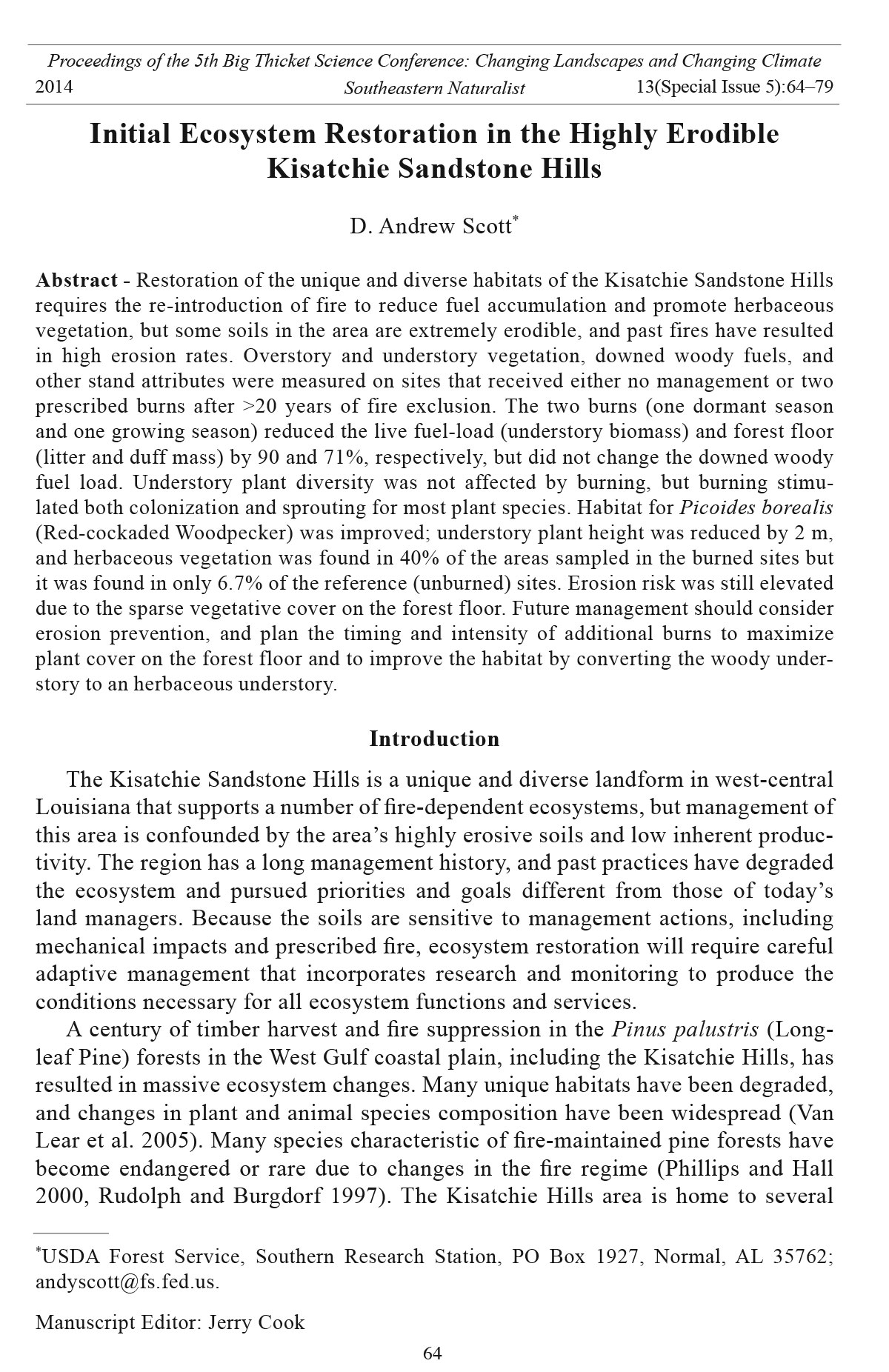
Figure 5. Understory conditions at representative locations in reference sites (A), and
burned sites (B) in the Kisatchie Sandstone Hills area near Gorum, LA. Photo was taken
approximately at 1.8 m, with the camera held level at the point of the photograph.
Southeastern Naturalist
D.A. Scott
2014
76
Vol. 13, Special Issue 5
woody fuel was found in the 1-, 10-, or 100-hour fuel classes, which averaged
0.06, 0.77, and 2.10 Mg ha-1, respectively. About 67% of the total downed woody
fuel was contained in the 1000-hr fuels, which averaged 5.8 Mg ha-1 across the 2
stand types (Table 1). The forest-floor thickness averaged about 6 cm in the reference
sites, while it averaged only about half that in the burned sites (Table 1).
Similarly, forest-floor mass in the burned sites was less than a third of what was
measured in the reference sites. Accordingly, the forest-floor density was also
about 32% lower in the burned sites than the reference sites.
The management goal for these burns was to reduce 1- and 10-hr fuels by
60–80%, 100-hr fuels by 30–40%, and 1000-hr fuels (up to 23-cm diameter)
by 10–20% (S. Staples, Kisatchie Ranger District Fire Management Officer,
Provencal, LA, pers. comm.). The lack of fuel reduction in the 1000-hr fuels
was not surprising, because both burns occurred before the normal extended
dry period in late summer, when fuels would have been drier and burned more
extensively. The absence of detectable differences in the levels of smaller fuels
could be due to either an ineffective burn or to increased fuel production following
the burns. Because the live fuels and forest floor were largely consumed, it is
likely that these burns were initially effective at reducing the lighter fuels. However,
the burns may have caused an increase in small branch senescence, thereby
increasing these lighter fuels. If this occurred, it would not likely continue following
another burn because the lower crown would have senesced. We observed
little to no scorch on the smaller fuel classes, further suggesting that the original
fuels were likely consumed but replaced by new fuel in the same class. Rideout
and Oswald (2002) also noted little decrease in fuel loadings in three areas in
East Texas and attributed the lack of response to ineffective burns, but the forest
floor was not consumed in their burns as it was in this study’s burns.
Soil erosion risk for physically undisturbed forests can be approximated by comparing
soil cover and canopy height above bare soil. These two variables control
erosion, and are affected by prescribed burning, especially where hydrophobicity
and soil sealing are not likely (Larsen et al. 2009). Because the vegetation canopy
intercepts rainfall before the droplets reach the ground, plant cover is an important
factor in determining rainfall impact energy. Generally speaking, an overstory
canopy that is >20 m tall reduces rainfall impact very little, but short, less than 2-m-tall
vegetation is almost as effective as actual soil cover at reducing rainfall impact and
the resultant soil detachment (Wischmeier 1975). The fires had no effect on the
overstory canopy, but reduced the vertical stratification of vegetation. Our results
suggest that soil protection by vegetative cover was likely the same after the burn as
before, but the forest-floor material was reduced in the two fires. A sparse cover of
recently fallen needles (Oi horizon) was maintained across most of the area, but no
Oe or Oa horizons (fermentation or duff layers) were found in burned areas (Tables
1, 4). We observed some soil cover, but it was sparse enough so that rainfall impact
would still be high and particle detachment would likely occur. This condition was
magnified in areas with lower overstory basal area, where litterfall was low, and in
areas where herbaceous vegetation was sparse. Although the extent of soil erosion
Southeastern Naturalist
77
D.A. Scott
2014 Vol. 13, Special Issue 5
that occurred after each fire was not quantified in this study, Haywood et al. (1995)
found high erosion rates for burned and unburned glade vegetation communities
with greater than 9.2 m2 ha-1 overstory basal area on Kisatchie soils (56.9 and 49.1
Mg ha-1, respectively). However, they found >25% bare soil or rock prior to burning,
whereas bare soil and rock was less than 2% in this study, regardless of treatment. In
our study, the post-burn reduction in the density of herbaceous species increased
erosion potential, but the concurrent increase in short vegetation (woody and herbaceous)
increased canopy cover.
Conclusions and Recommendations
Restoring the native vegetation and habitat on highly erodible soils in the
Kisatchie Hills will require careful management actions. An initial two-burn plan,
consisting of a cool dormant-season burn to reduce fuel loads, followed by a warm
growing-season burn to top-kill undesirable woody vegetation and increase herbaceous
vegetation reduced the overall fuel load, increased herbaceous vegetation,
and improved the vertical structure for RCW habitat. However, this initial action
resulted in increased total woody plant and stem density, and a reduction in forestfloor
density. Soil erosion risk response was mixed—the increase in short woody
and herbaceous vegetation reduced the canopy height, but density of the protective
forest-floor layer was reduced. Future burns should be planned to continue to topkill
the undesired woody vegetation; further fuel-reduction burns are not needed at
this time.
Acknowledgments
This research was made possible by the cooperation of several individuals. Field and
laboratory sampling was conducted by Rick Stagg, Morris Smith, Jr., and Jacob Floyd.
Nancy Koerth, Craig Rudolph, and Brian Oswald provided invaluable suggestions on an
earlier draft. Finally, Steven Staples, Bruce Prud’homme, Bradley Kohls, John Novosad,
and Mike Dawson of the Kisatchie National Forest provided the impetus and collaboration
necessary to conduct the research.
Literature Cited
Benjamini, Y., and Y. Hochberg. 1995. Controlling the false discovery rate: A practical and
powerful approach to multiple testing. Journal of the Royal Statistical Society, Series B
(Methodological) 57:289–300.
Brown, J.K. 1974. Handbook for inventorying downed woody material. Gen. Tech. Rep.
INT-016. US Department of Agriculture, Forest Service, Intermountain Forest and
Range Experiment Station, Ogden, UT. 25 pp.
Callaham, M.A., Jr., D.A. Scott, J.J. O’Brien, and J.A. Stanturf. 2012. Cumulative effects
of fuel management on the soils of eastern U.S. Pp. 202-228 In: LaFayette, R., M.T.
Brooks, J.P. Potyondy, L. Audin, S.L. Krieger, C.T. Trettin (Eds.) Cumulative watershed
effects of fuel management in the Eastern United States. Gen. Tech. Rep. SRS-161. US
Department of Agriculture, Forest Service, Southern Research Station, Asheville, NC.
Dontsova, K.M., and L.D. Norton. 2002. Clay dispersion, infiltration, and erosion as influenced
by exchangeable Ca and Mg. Soil Science 167:184–193.
Southeastern Naturalist
D.A. Scott
2014
78
Vol. 13, Special Issue 5
Drewa, P.B., W.J. Platt, and E.B. Moser. 2002. Fire effects on resprouting of shrubs in headwaters
of southeastern Longleaf Pine savannas. Ecology 83:755–767.
Drewa, P.B., J.M. Thaxton, and W.J. Platt. 2006. Responses of root-crown-bearing shrubs
to differences in fire regimes in Pinus palustris (Longleaf Pine) savannas: Exploring
old-growth questions in second-growth systems. Applied Vegetation Science 9:27–36.
English, P.F. 1932. Some habits of the pocket gopher, Geomys breviceps breviceps. Journal
of Mammalogy 12:253–256.
Haywood, J.D., A. Martin, Jr., and J.C. Novosad. 1995. Responses of understory vegetation
on highly erosive Louisiana soils to prescribed burning in May. Research Note SO-383.
US Department of Agriculture Forest Service, Southern Forest Experiment Station, New
Orleans, LA. 8pp.
Kisatchie National Forest Staff. 1999a. Final environmental impact statement. US Department
of Agriculture, Forest Service. Pineville, LA.
Kisatchie National Forest Staff. 1999b. Revised land and resource management plan. US
Department of Agriculture, Forest Service. Pineville, LA.
Larsen, I.J., L.H. MacDonald, E. Brown, D. Rough, M.J. Welsh, J.H. Pietraszek, Z. Libohova,
J. de Dios Benavides-Solorio, and K. Schaffrath. 2009. Causes of post-fire runoff
and erosion: Water repellency, cover, or soil sealing? Soil Science Society of America
Journal 73:1393–1404.
Neary, D.G., K.C. Ryan, and L.F. DeBano. 2008. Wildland fire in ecosystems: Effects of fire
on soils and water. Gen. Tech. Rep. RMRS-GTR-42-vol.4. US Department of Agriculture,
Forest Service, Rocky Mountain Research Station, Ogden, UT. 250 pp.
Phillips, L.C, and B.S. Hall. 2000. A historical view of Red-cockaded Woodpecker habitat
on Fort Polk, Louisiana. Journal of Field Ornithology 71:585–596.
Rideout, S., and B.P. Oswald. 2002. Effects of prescribed burning on vegetation and fuel
loading in three East Texas state parks. Texas Journal of Science 54:211–226.
Rudolph, D.C., and S.J. Burgdorf. 1997. Timber Rattlesnakes and Louisiana Pine Snakes
of the West Gulf coastal plain: Hypotheses of decline. Texas Journal of Science
49:111–122.
Rudolph, D.C., R.N. Conner, and R.R. Schaeffer. 2002. Red-cockaded Woodpecker foraging
behavior in relation to midstory vegetation. Wilson Bulletin 114:235–242.
Rudolph, D.C., S.J. Burgdorf, R.R. Schaefer, R.H. Conner, and R.W. Maxey. 2006. Status
of Pituophis ruthveni (Louisiana Pine Snake). Southeastern Naturalist 5:463–472.
SAS Institute, Inc. 2004. SAS/STAT 9.1 User’s Guide. SAS Institute, Inc., Cary, NC.
Schoelerman, L. 1981. Soil monitoring evaluation report for prescribed burning on the
Bayou Luce sub-watershed, Kisatchie Ranger District. Internal report, Kisatchie National
Forest, US Department of Agriculture, Forest Service. Pineville, LA.
Scott, D.A., R.H. Stagg, and M.A. Smith, Jr. 2006. A non-destructive method for quantifying
small-diameter woody biomass in southern pine forests. Pp. 358, In K.F. Connor
(Ed.). Proceedings of the 13th Biennial Southern Silvicultural Research Conference.
Gen. Tech. Rep. SRS-92. US Department of Agriculture, Forest Service, Southern Research
Station, Asheville, NC.
Shannon, C.E. 1948. A mathematical theory of communication. Bell System Technical
Journal 27:379–423.
Soil Conservation Service. 1990. Soil Survey of Natchitoches Parish, Louisiana. US Department
of Agriculture, Soil Conservation Service. 133 pp.
Stambaugh, M.C., R.P. Guyette, and J.M. Marschall. 2011. Longleaf Pine (Pinus palustris
Mill.) fire scars reveal new details of a frequent fire regime. Journal of Vegetation Science
22:1094–1104.
Southeastern Naturalist
79
D.A. Scott
2014 Vol. 13, Special Issue 5
Sulentich, J.M., L.R. Williams, and G.N. Cameron. 1991. Geomys breviceps. Mammalian
Species 383:1–4.
US Fish and Wildlife Service. 2003. Recovery plan for the Red-cockaded Woodpecker (Picoides
borealis): Second revision. US Fish and Wildlife Service, Atlanta, GA. 296 pp.
Van Kley, J.E. 1999. The vegetation of the Kisatchie Sandstone Hills, Louisiana. Castanea
64:64–80.
Van Lear D.H., W.D. Carroll, P.R. Kapeluck, and R. Johnson. 2005. History and restoration
of the Longleaf Pine-grassland ecosystem: Implications for species at risk. Forest Ecology
And Management. 211:150–165.
Wischmeier, W.H. 1975. Estimating the soil loss equation’s cover and management factor
for undisturbed areas. Pp. 118–124, In Present and Prospective Technology for Predicting
Sediment Yield and Sources: Proceedings of the Sediment-Yield Workshop, USDA
Sedimentation Laboratory, Oxford, MS, Nov. 28-30, 1972. ARS-40. US Department of
Agriculture, Agricultural Research Service, Southern Region, New Orleans, LA.


 The Southeastern Naturalist is a peer-reviewed journal that covers all aspects of natural history within the southeastern United States. We welcome research articles, summary review papers, and observational notes.