Southeastern Naturalist
B.P. Oswald, M.M. Bataineh, I.V. McWhorter, M.H. Legg, and D.R. Unger
2014
80
Vol. 13, Special Issue 5
Fire Exclusion Effects within the Pinus palustris
Communities of Upland Island Wilderness, Texas
Brian P. Oswald1,*, Mohammad M. Bataineh2, Ira V. McWhorter3,
Michael H. Legg1, and Daniel R. Unger1
Abstract - This study quantifies differences in vegetation richness, composition, and structure
between sites where fire has been excluded for 20 years and frequently burned sites
in a Pinus palustris (Longleaf Pine) community within the Upland Island Wilderness in
eastern Texas. Sixty plots were allocated equally between two sites: Upland Island, where
fire had been excluded, and Boykin Spring, where fires were frequent. Plots were stratified
within 3 relative topographic positions: lower slopes, upper slopes, and ridges. We collected
data on vegetation within four strata (herbaceous, woody understory, mid-story, overstory)
and on site parameters. Compared to the frequently burned site, the fire-excluded site had
lower herbaceous species richness and cover, greater cover by shrubs and other pines in the
understory and midstory, a denser midstory, and less Longleaf Pine regeneration. Overall,
vegetation differences did not appear to be shaped by any underlying local edaphic and
physiographic gradients. Our data demonstrated the effectiveness of a burning regime in
maintaining and possibly recreating historic stand structure and diversity. It may be necessary
to increase burning frequency to once every 2–3 years at Upland Island to reduce
hardwood re-sprouts from emerging into the understory and midstory strata.
Introduction
At the time of Euro-American settlement, fire-dependent Pinus palustris Mill.
(Longleaf Pine) forests and savannas encompassed approximately 37 million ha in
the southeastern US (Frost 1993). Early accounts described them as open, park-like
stands of towering pines above a well-developed and diverse groundcover of grasses
and herbs (Bray 1904, Bridges and Orzell 1989, Chapman 1932, Foster et al.
1917, Frost et al. 1986, Harper 1920, Peet and Allard 1993). Frequent low intensity
fires, sparked by lightning and Native Americans, limited hardwood encroachment
and enhanced regeneration of Longleaf Pine and a host of other fire-adapted species
(Hiers et al. 2007). Currently, Longleaf Pine communities occupy less than
1.2 million ha (Kush et al. 2000), and are often characterized by increased tree
density, shifts in composition toward hardwood species, suppressed Longleaf Pine
regeneration, and fuel accumulation (Gilliam and Platt 1999, Landers et al. 1995),
attributed mainly to post-settlement land-use conversion, and fire exclusion (Frost
1993, Gilliam and Platt 2006).
1Arthur Temple College of Forestry and Agriculture, Stephen F. Austin State University, PO
Box 6109 SFA Station, Nacogdoches, TX 75962-6109. 2US Forest Service-CFRU, Univeristy
of Maine, Orono, ME 04469. 3US Forest Service, National Forests and Grasslands of
Texas, Lufkin, TX 75901. *Corresponding author - boswald@sfasu.edu.
Manuscript Editor: Jerry Cook
Proceedings of the 5th Big Thicket Science Conference: Changing Landscapes and Changing Climate
2014 Southeastern Naturalist 13(Special Issue 5):80–92
Southeastern Naturalist
81
B.P. Oswald, M.M. Bataineh, I.V. McWhorter, M.H. Legg, and D.R. Unger
2014 Vol. 13, Special Issue 5
Despite the wealth of available literature regarding Longleaf Pine communities,
few studies have explicitly quantified the effects of long-term fire exclusion (Gilliam
and Platt 1999; Heyward 1939; Kush and Meldahl 2000, 2006). Moreover,
virtually all of the available studies were conducted in the eastern and southern
parts of the distribution range with little to no data from the western edge of Longleaf
Pine’s range.
The most logical and commonly used approach to restoring fire-dependent
ecosystems is fire reintroduction (Boyer 1979, Hanula and Wade 2003, Moser and
Wade, 2005). Natural fire is inferred to have occurred at a pre-settlement frequency
of 1–10 years (Chapman 1932), and prescribed burning is widely used to mimic
a natural fire regime of recurring low-intensity surface fires in these communities
(Varner et al. 2000, Wade et al. 1998). Appropriate burn regimes are site-specific,
and social, economic, and ecological constraints should be considered, but the results
of several studies suggest burning frequencies of 1–3 years create conditions
that meet restoration and management objectives, such as fuel-hazard reduction,
increased species richness, increased tree growth, and reduced hardwood competition
(Brockway and Lewis 1997, Chapman, 1909, Glitzenstein et al. 2003, Sackett
1975). Although it is presumed that growing-season burns mimic the historic fire
regime (Hanula and Wade 2003), dormant-season burns are often recommended
as a useful management and restoration option (Brockway and Lewis 1997, Glitzenstein
et al. 2003, Kush et al. 2000). Dormant-season and growing-season fires
reflect differences in fire intensity and severity that obviously would impact any
post-fire vegetation recovery.
This study quantifies differences in vegetation richness, composition, and structure
in two areas of a Pinus palustris (Longleaf Pine) community within Upland
Island Wilderness in eastern Texas: one where fire had been prevented for 20 years
and one that had been frequently burned (4–5 years return interval). The Upland
Island Wilderness represented a unique opportunity to examine differences in fireexcluded
and frequently burned areas at the western extent of the species’ range,
thus providing for evaluation of potential variation in fire exclusion effects across
geographical locations and environmental conditions. We hypothesized that vegetation
differences would be partly explained by the underlying local edaphic and
physiographic gradients, and we quantified vegetation attributes across all vegetation
strata.
Study Area
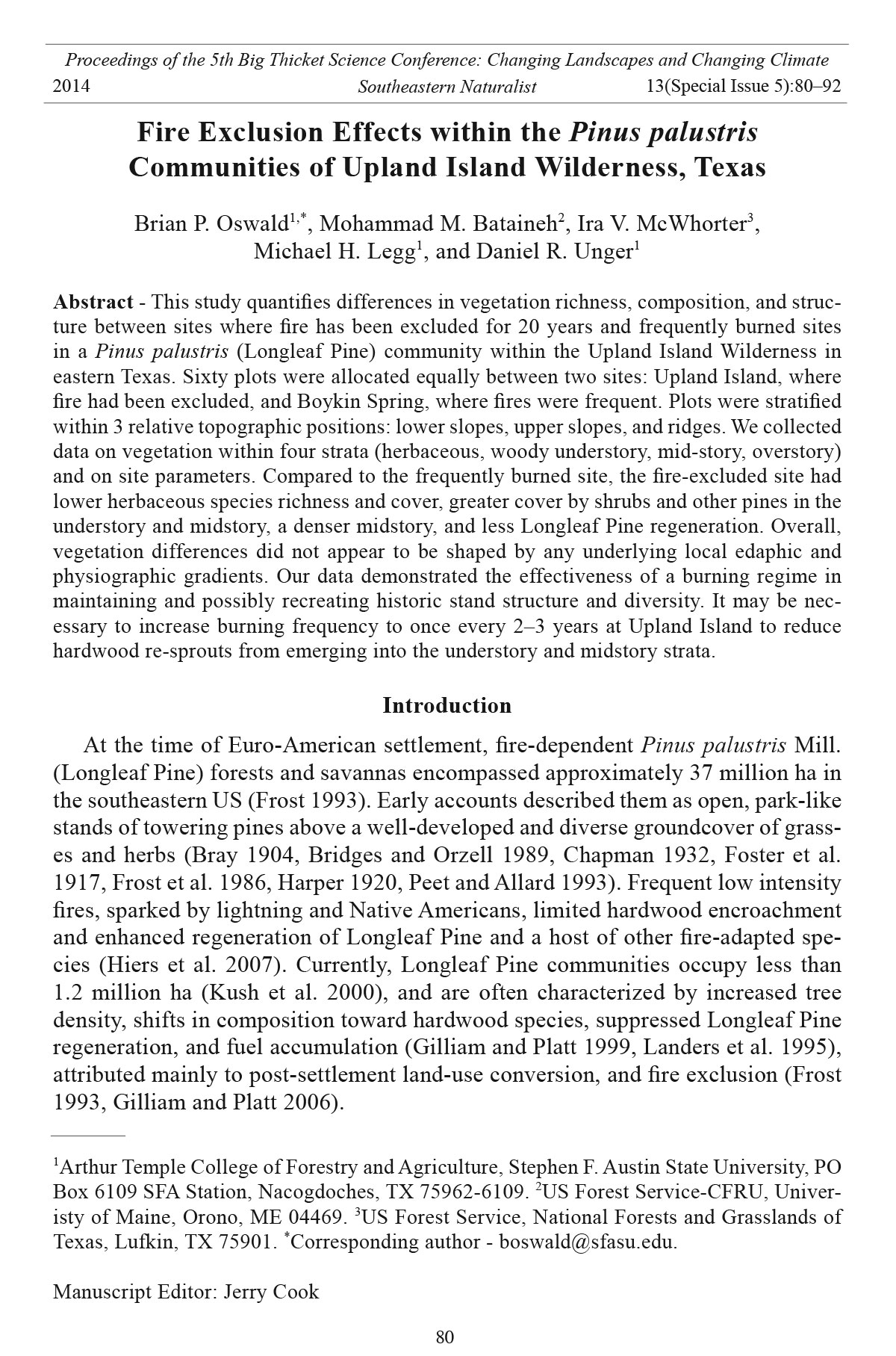
The study was located within The Angelina National Forest, TX, and includes
Longleaf Pine stands in the Upland Island Wilderness and Longleaf Ridge, hereafter
referred to as Upland Island and Boykin Spring, respectively (Fig. 1). Upland
Island and Boykin Spring areas are located on the Catahoula formation, which
consists primarily of tuffaceous sandstone and is characterized by rocky outcrops
and steep slopes (USDA SCS 1988). Before receiving their wilderness designation
in 1984, but after pre-1900 cutting of the area by timber companies, and the establishment
of the Angelina National Forest, both sampling areas had been managed
Southeastern Naturalist
B.P. Oswald, M.M. Bataineh, I.V. McWhorter, M.H. Legg, and D.R. Unger
2014
82
Vol. 13, Special Issue 5
by the US Forest Service in a similar fashion, including planting Longleaf Pine and
other pines between 1935–1941, but not necessarily on the study sites, and application
of prescribed burning under similar intervals and prescriptions, although not
necessarily in the same years. In addition, thinning and management for Picoides
borealis Vieillot (Red-cockaded Woodpecker) habitat have been conducted within
the Boykin Spring area since 1984. Since receiving their wilderness designation,
the two areas represented contrasting fire history conditions. Fire exclusion from
Upland Island spanned two decades, whereas Boykin Spring continued to be
regularly burned during the dormant season over the same period with fire return
intervals of 4 to 5 years. The area is considered the western edge of the historic
range of Longleaf Pine and has been described as the contemporary inland limit for
the continuous and widespread Longleaf Pine communities in Texas (Bridges and
Orzell 1989).
The area is dominated by Letney loamy sands (loamy, siliceous, semiactive,
thermic Arenic Paleudults), Stringtown (fine-loamy, siliceous, semiactive,
thermic Typic Hapludults) and Kisatchie (fine smectitic Thermic Typic Hapludalfs)
fine sandy loams, and Rentzel (loamy, siliceous, semiactive, thermic
Figure 1. Location of the study area within the historical distribution range of Longleaf
Pine, and the spatial arrangement of sampling sites within Upland Island Wilderness and
Longleaf Ridge areas of the Angelina National Forest, TX.
Southeastern Naturalist
83
B.P. Oswald, M.M. Bataineh, I.V. McWhorter, M.H. Legg, and D.R. Unger
2014 Vol. 13, Special Issue 5
Arenic Plinthaquic Paleudults) loamy fine sand with highly permeable surface
layers. The climate of the study area is subtropical and humid. Summers are
hot, with a mean daily high of 34 °C in July, and winters are mild, with a mean
minimum temperature of 2 °C in January. Average annual rainfall is 134 cm. December
and May, the wettest months, each have an average rainfall of 14.2 cm;
August and October, the driest months, each have an average rainfall of 9.1 cm
(Ramos 2003).
Methods
We randomly selected two sampling sites in Upland Island (High Point and
Falls Creek) and two sampling sites in Boykin Spring (Boykin North and Boykin
South). Each site was stratified into 3 slope positions—ridges, upper slopes, and
lower slopes—for a total of twelve 2- to 5-ha sampling units. Five 0.04-ha circular
sampling plots (60 total) were randomly established in each sampling unit. Within
each plot, we identified herbaceous vegetation to the species level when possible,
and we estimated cover utilizing the line-intercept method along three 11.3-m-long
radial transects on bearings of 0, 120, and 240 degrees around the plot center. We
classified woody plants <1.4m tall as part of the woody understory and we tallied
them by species within three 2-m x 10-m subplots positioned along the right side
of the line transects. Diameter at breast height (dbh) of midstory trees and shrubs
(height > 1.4 m, dbh < 11.4 cm) was measured to the nearest 0.1 cm within three
4-m x 10-m rectangular subplots which overlapped the 2-m x10-m subplots. We
measured the dbh of all overstory trees (dbh ≥ 11.4 cm) within the entire 0.04-ha
circular plot, and we estimated canopy closure using a spherical densiometer in the
four cardinal directions at the 5.7-m mark of each transect. Samples of the A and
B soil horizons were collected at the center of each plot to determine percent sand
in both horizons, depth to the argillic B horizon, and percent clay in the B horizon.
We also recorded aspect and percent slope for each plot.
We calculated herbaceous cover (%) as the proportion of accumulated length
occupied by one species to total transect length. Woody understory and midstory
densities (stems ha-1) were calculated as mean estimates of three subplots. Importance
values were calculated using relative basal area (m2) and relative density
(number of individuals/plot) of overstory and midstory (Mueller-Dombois and
Ellenberg 1974). Plot values were pooled to provide mean estimates per sampling
unit for each of the following: herbaceous cover, woody understory density, midstory
density and basal area, and overstory density and basal a rea. The availability
of only two areas of contrasting fire history, and thus a single true replicate per fire
treatment, constitutes simple pseudoreplication (Hurlbert 1984), a common situation
in fire-effect studies (Van Mantgem et al. 2001). This pseudoreplication implies
that our results are only applicable to the sampled areas since subsamples were used
as replicates. Effect of the fixed factors, site (2 levels) and slope position (3 levels),
were tested using a two-factor ANOVA in PROC GLM (SAS Institute, Inc. 1999).
Tukey’s HSD multiple comparison procedure was used whenever a significant effect
was found.
Southeastern Naturalist
B.P. Oswald, M.M. Bataineh, I.V. McWhorter, M.H. Legg, and D.R. Unger
2014
84
Vol. 13, Special Issue 5
Patterns in vegetation strata were related to the underlying local gradients through
indirect gradient analysis (McCune and Grace 2002). Overstory importance values,
midstory importance values, herbaceous cover percentages, and woody understory
density, along with plot attribute data (i.e., soil texture variables, aspect, slope inclination,
canopy closure, fire history, and slope position) were utilized. Non-metric
multi-dimensional scaling (NMDS) was used as the data-reduction technique, and
the Bray-Curtis coefficient was used as the distance measure. Indicator species analysis
(ISA) was used to identify characteristic species (Dufrẻne and Legendre 1998).
A Monte Carlo randomization test with 10,000 permutations was used to assess the
statistical significance of indicator values. Only species with significant (at the 0.05
level) indicator values that were greater than 25% were considered indicator species.
ISA and NMDS were performed using the autopilot procedure with PC-ORD software
(McCune and Mefford 1999). We related site attributes to vegetation patterns
through overlays and correlations as descriptive measures, and we also used site attributes
to construct joint plots in which attribute variables were represented as lines
radiating from the ordination scores centroid.
Results
Herbaceous vegetation
We identified a total of 102 herbaceous species: 43 species exclusively in Boykin
Spring and 6 species exclusively in Upland Island. Pteridium aquilinum (L.) Kuhn.
(Western Bracken Fern), Schizachyrium scoparium (Michx.) Nash. (Little Bluestem),
Gelsemium sempervirens L. (Evening Trumpetflower), and Toxicodendron
radicans L. (Eastern Poison Ivy) were the dominant species in frequently burned
units; the latter three were also dominant in fire-excluded units. Upland Island had
significantly lower mean species richness (P = 0.001, F = 36.57, df = 1) and plant
cover (P = 0.006, F = 17.53, df = 1) (Tables 1, 2). Mean species richness and cover
did not differ significantly among slope positions (P = 0.076, F = 4.08, df = 2 and
P = 0.958, F = 0.04, df = 2, respectively), and no significant interactions were revealed
between site and slope position for richness or cover (P = 0.511, F = 0.75,
df = 2 and P = 0.659, F = 0.45, df = 2, respectively).
Nine species were identified as indicators of frequently burned areas, of which
Aristolochia serpentaria L. (Virginia Snakeroot), Dichanthelium spp. L. (rosette
grasses), Vitis aestivalis Michx. (Summer Grape), and Vernonia texana Small (Texas
Ironweed) are pioneer species that commonly occur after disturbance (Table 3).
Little Bluestem cover is also known to increase after fire (Wright 1974). Tragia
urticifolia Michx. (Nettleleaf Noseburn), often found in open dry habitats, was an
indicator of ridges. A NMDS solution with two axes represented 76.8% and 16.4%,
respectively, of the total variation in herbaceous data; final stress and instability
were 5.07 and <0.0001, respectively. Lower slopes were separated from ridges and
upper slopes along the first axis, and burned sites were separated from unburned
sites along the second axis (Fig. 2). Canopy closure (r = -0.83) and percentage of
sand in the A horizon (r = 0.71) were strongly correlated with the first axis, indicating
more canopy closure and less A horizon sand on lower slopes.
Southeastern Naturalist
85
B.P. Oswald, M.M. Bataineh, I.V. McWhorter, M.H. Legg, and D.R. Unger
2014 Vol. 13, Special Issue 5
Woody Understory
We identified a total of 39 woody understory species, with Sassafras albidum
(Nutt.) Nees (Sassafras) dominant at both sites. Ilex vomitoria L. (Yaupon), Morella
cerifera L. (Wax Myrtle), and Vaccinium elliottii Chapm. (Elliott’s Blueberry) were
dominant on unburned sites, and Yaupon was an indicator species. Quercus stellata
Wang (Post Oak), Vaccinium stamineum L. (Deerberry), and Quercus marilandica
Muenchh. (Blackjack Oak) were dominant in burned sites, with Quercus incana
Bartr. (Bluejack Oak), Rhus copallinum L. (Winged Sumac), and Asimina parviflora
(Michx.) Dun (Dwarf Pawpaw) as indicators (Table 3). Acer rubrum L. (Red Maple),
Quercus nigra L. (Water Oak), and Liquidambar styraciflua L. (Sweetgum) were
indicator species of lower slopes. Mean woody understory density (P = 0.165, F =
2.50, df = 1), richness (P = 0.687, F = 0.18, df = 1), and slope position (P = 0.448,
F = 0.92, df = 2 and P = 0.126, F = 2.99, df = 2, respectively) did not differ significantly
among sites (Tables 1, 2). Longleaf Pine seedlings had greater mean density
in Boykin Springs (544 ± 228 [mean ± SE]), compared to Upland Island (228 ± 78).
Table 2. Mean estimates, with standard error in parenthesis, of species richness as number of species
per sampling unit for vegetation strata by site and slope position. Means followed by the same letter
within a sub-column are not significantly different (α = 0.05). No significant (α = 0.05) interaction was
found between site and slope position.
Fire treatment n Herbaceous Woody understory Midstory Overstory
Fire excluded 6 22.7 (3.9)a 14.3 (2.0)a 12.3 (324)a 5.3 (1.4)a
Burned 6 47.5 (3.3)b 15.5 (2.3)a 6.8 (178)a 3.8 (0.9)a
Slope position
Ridge 4 37.5 (5.7)a 13.8 (1.5)a 7.8 (1.7)a 3.3 (0.6)a
Upper 4 40.8 (8.5)a 11.5 (1.6)a 7.8 (2.7)a 4.0 (1.2)a
Lower 4 27.0 (9.0)a 19.5 (2.7)a 13.3 (2.7)a 6.5 (1.9)a
Table 1. Mean estimates, with standard error in parenthesis, of vegetation-strata response variables
by site and slope position. BA = basal area (m2 ha-1). Means followed by the same letter within a
sub-column are not significantly different (α = 0.05). No significant (α = 0.05) interaction was found
between fire treatment and slope position. Densities given in no . per hectare.
Woody
Herbaceous understory Midstory Overstory
n cover (%) Density Density BA Density BA
Fire excluded 6 8.2a 8400a 3194a 2.12a 412a 32.31a
(6.6) (1503) (324) (0.30) (31) (1.86)
Burned 6 29.5b 16,428a 1192b 0.47b 273b 23.21b
(14.2) (2742) (178) (0.11) (23) (1.93)
Slope position
Ridge 4 19.6a 17,100a 1921a 0.76a 335ab 29.69ab
(7.1) (6485) (556) (0.21) (46) (4.12)
Upper 4 19.2a 8917a 1950a 1.35a 255a 21.69a
(6.6) (2986) (1079) (0.80) (30) (1.92)
Lower 4 17.8a 11,225a 2708a 1.77a 436b 31.91b
(8.0) (2929) (399) (0.83) (69) (3.45)
Southeastern Naturalist
B.P. Oswald, M.M. Bataineh, I.V. McWhorter, M.H. Legg, and D.R. Unger
2014
86
Vol. 13, Special Issue 5
Table 3. Significant (P < 0.05) indicator values (>25%) in descending order for indicator species
within each vegetation stratum of site and slope position.
Indicator
Species A priori group value (%) P-value
Herbaceous
Rhynchosia latifolia Vail (Prairie Snoutweed) Frequently burned 95.0 0.003
Aristolochia serpentaria 88.0 0.007
Coelorachis cylindrical (Michx.) Nash (Cylinder Jointtail Grass) 83.3 0.016
Galactia volubilis (L.) Brittion (Downy Milkpea) 83.3 0.016
Vernonia texana (A. Gray) Small (Texas Ironweed) 83.3 0.016
Vitis aestivalis 83.3 0.016
Dichanthelium spp. 73.6 0.005
Mimosa quadrivalvis L. (Fourvalve Mimosa) 71.4 0.048
Schizachyrium scoparium 70.8 0.016
Tragia urticifolia Ridge 63.2 0.041
Woody understory
Ilex vomitoria Fire excluded 76.2 0.031
Rhus copallinum Frequently burned 92.2 0.005
Quercus marilandica 80.1 0.007
Quercus incana 77.8 0.021
Asimina parviflora 73.0 0.025
Acer rubrum Lower 100.0 0.006
Quercus nigra 100.0 0.006
Liquidamabr styraciflua 79.5 0.006
Quercus phellos (L.) (Willow Oak) 72.3 0.042
Vaccinium arboreum Marshall (Farkleberry) 62.6 0.043
Midstory
Pinus taeda L. (Loblolly Pine) Fire excluded 100.0 0.002
Ilex vomitoria 69.7 0.023
Acer rubrum Lower 84.8 0.006
Liquidamabr styraciflua 76.7 0.019
No Longleaf Pine seedlings were recorded in lower slopes of frequently burned units.
As a proportion of total woody stems, oak seedlings represented 27% on unburned
Boykin Springs sites and 7% on frequently burned Upland Island units. A threedimensional
solution was appropriate with axes representing 81.0%, 7.5%, and 3.1%
of the total variation in understory data, respectively (final stress and instability were
4.07 and <0.0001, respectively). Variation along the first axis reflected differences in
slope position, canopy closure (r = -0.82), and percentage of sand in the A horizon (r =
0.67) (Fig. 2). Boykin Spring sites were separated from Upland Island sites along the
second axis with an overlap between lower slope Boykin Spring plots and two Upland
Island plots, indicating that woody understory density and composition on burned
lower slopes resembled fire-excluded higher slopes.
Midstory
We identified a total of 34 species, and found 17 of them only in Upland Island and
4 only in Boykin Spring. Yaupon, Callicarpa americana L. (American Beautyberry),
and P. taeda (Loblolly Pine) were the most important species in Upland Island, while
Southeastern Naturalist
87
B.P. Oswald, M.M. Bataineh, I.V. McWhorter, M.H. Legg, and D.R. Unger
2014 Vol. 13, Special Issue 5
in Boykin Spring, Longleaf Pine was the most important, followed by Blackjack Oak
and American Beautyberry. Mean density and basal area were significantly greater
at Upland Island (P = 0.014; F = 11.91; df = 1 and P = 0.021; F = 9.71; df = 1, respectively)
(Table 1). Loblolly Pine and Yaupon were identified as indicator species of fire
excluded units and Sweetgum and Red Maple were identified as indicators of lower
slopes (Table 3). Two-dimensional solution axes represented 8.5% and 83.7% of the
total variation in midstory data (final stress and instability were 6.66 and < 0.0001,
respectively). Upland Island and Boykin Spring were separated along the first axis,
whereas variation in slope position was reflected along the second axis (Fig.2).
Percentage of sand in the A horizon (r = 0.66) and aspect (r = 0.65) were strongly correlated
with the second axis, reflecting the greater percentage of sand in the A horizon
and the more southerly exposure of upper slopes.
Figure 2. Non-metric multi-dimensional scaling (NMDS) of herbs (a), woody understory
(b), and midstory (c) strata. Open circles represent unburned sampling sites, shaded circles
represent frequently burned sampling sites, and vectors represent relationship of each axis
ordination scores to the measured attribute variables.
Southeastern Naturalist
B.P. Oswald, M.M. Bataineh, I.V. McWhorter, M.H. Legg, and D.R. Unger
2014
88
Vol. 13, Special Issue 5
Overstory
We identified a total of 16 species, with Longleaf Pine the most important in
both sites. Mean tree density (P = 0.008, F = 14.92, df = 1) and basal area (P =
0.011, F = 13.19, df = 1) were significantly greater on unburned Upland Island
sites than on frequently burned Boykin Spring sites (Table 1). Lower slopes had
significantly greater mean density (P = 0.018; F = 8.48; df = 2) and basal area (P =
0.035; F = 6.13; df = 2) than upper slopes, but our analyses indicated no other significant
relationships or indicator species. A one-dimensional solution represented
78.1% of the variation in overstory data (final stress and instability were <0.0001
and <0.0001, respectively) and reflected site dif ferences.
Discussion
Substantial differences in vegetation attributes between a site where fire had been
excluded for two decades and a site with a burn interval of 4–5 y were documented
within the Longleaf Pine communities of Upland Island Wilderness. The fire-excluded
site had lower herbaceous species richness and cover, dominance of shrubs and
other pines in the understory and midstory, denser midstory, and less Longleaf Pine
regeneration than the frequently burned site. Previous work conducted throughout
the historical distribution range of Longleaf Pine yielded similar results regarding
vegetation patterns in fire-exclusion areas (Brockway and Lewis 1997, Heyward
1939, Outcalt and Brockway 2010, Stokes et al. 2010, Varner et al. 2000). Our study
area was dominated in the midstory by tall thickets of Yaupon, whereas Heyward
(1939) and Brockway and Lewis (1997) found that Georgia and Florida flatwoods
undergrowth was dominated by Ilex glabra L. (Short Gallberry). This difference may
imply greater suppression of herbaceous plants as well as greater fuel loading in case
of wildfires (Brockway et al. 2009). Even in the Yaupon-dominated undergrowth of
Alabama (Outcalt and Brockway 2010), midstory density was less than half of that
in Upland Island, despite the inclusion of a smaller range of diameters in our sample.
Moreover, Upland Island had greater tree density and basal area than that reported for
fire-excluded communities of Alabama (Outcalt and Brockway 2010, Stokes et al.
2010). Longleaf Pine regeneration at Upland Island was greater than that reported for
montane Longleaf Pine communities in Alabama and North Carolina sandhills (Gilliam
and Platt 1999, Stokes et al. 2010). The regeneration of North Carolina sandhills
could be partly attributed to a much longer (>80 years) period of fire exclusion than
what we sampled at Upland Island.
Although an indication of the influence of local site factors on vegetation attributes
was detected in the ordination graphs, and larger proportions of the variation
in vegetation strata were represented by these local gradients (Fig. 2), in general
these differences did not translate into significant differences in mean response
among slope positions (Tables 1, 2). In contrast, variation in vegetation attributes
between fire excluded and frequently burned sites were clearly shown in the ordination
graphs but represented smaller proportions of the variation across all
strata except the overstory. Nevertheless, significant differences in mean response
between sites were pronounced (Tables 1, 2). This result indicates that differences
Southeastern Naturalist
89
B.P. Oswald, M.M. Bataineh, I.V. McWhorter, M.H. Legg, and D.R. Unger
2014 Vol. 13, Special Issue 5
between sites cannot be explained by local site factors alone and that site history
has played a role in the observed differences. The most obvious difference in site
history is that of fire exclusion, but this is not to say that other management decisions
have not played a role. Differences in initial establishment, burning practices
before 1984, and thinning and management for Red-cockaded Woodpecker have
also played a role in the observed differences. Within the frequently burned Boykin
Spring area, Red-cockaded Woodpecker habitat management has created a patchy
overstory that has likely contributed to the variability we observed in the understory.
Conversely, the unthinned overstory at unburned Upland Island created a
largely continuous canopy, at least initially, and regeneration of both overstory and
understory species was limited to openings created by overstory mortality, rather
than in openings created by thinning activities
The burning regime at Boykin Spring maintained herbaceous species richness
and cover, reduced midstory shrub and tree cover, and increased Longleaf
Pine regeneration, confirming previously reported results (Brockway and Lewis
1997, Gilliam and Platt 1999, Outcalt and Brockway, 2010, Stokes et al. 2010).
However, the areas with relatively low frequency of burning areas had a preponderance
of understory hardwoods, especially oaks. The likelihood for establishment
of hardwood seedlings in the relatively dense and frequently burned herbaceous
understory is low, and it is more probable that these understory hardwoods are
re-sprouts from well-established root-stocks that persist despite a frequent burning
regime (Brose et al. 1998). The relatively long fire-free interval has allowed many
of these suppressed root-stocks to re-sprout and emerge into the more favorable
understory environment resulting from the previous fire. However, increasing burning
frequency to 2–3 years may reduce hardwood re-sprouts from emerging into
the understory and midstory strata (Outcalt and Brockway 2010). Comparisons of
mechanical, chemical, and fire restoration methods for oak reduction in Longleaf
Pine by Provencher (2001) and Provencher et al. (2001) support this outcome as
well, even though the most effective methods, mechanical and chemical, are not
viable for use in the Upland Island Wilderness
Conclusions
Substantial differences in the Longleaf Pine communities of Upland Island
Wilderness, in the form of reduced herbaceous species richness and cover, a shift
in species composition toward shrubs and other pines in the understory and midstory,
development of a dense midstory, and reduced Longleaf Pine regeneration
were associated with fire exclusion. When contrasted with other fire-excluded
areas within the Longleaf Pine’s historical distribution range, fire-excluded Upland
Island appeared to require the immediate attention of restoration managers.
Vegetation differences did not seem to be shaped by the underlying local edaphic
and physiographic gradients, but at Upland Island may have been influenced by a
well-developed midstory influencing available resources for understory species.
A frequent prescribed burning regime, with a mean fire return interval of 4 to 5
years, would be effective in reducing midstory shrubs and trees to open the forest
Southeastern Naturalist
B.P. Oswald, M.M. Bataineh, I.V. McWhorter, M.H. Legg, and D.R. Unger
2014
90
Vol. 13, Special Issue 5
floor to sunlight, thereby increasing herbaceous species richness and cover, and
increasing Longleaf Pine regeneration. A burning frequency of 2–3 years may be
necessary to reduce hardwood re-sprouts from emerging into the understory, and
eventually to the midstory stratum.
Literature Cited
Boyer, W.D. 1979. Regenerating the natural Longleaf Pine forest. Journal of Forestry 77:9.
Bray, W.L. 1904. Forest resources of Texas, US Department of Agriculture, Bureau of Forestry,
Bulletin No. 47. Washington, DC. 71 pp.
Bridges, E.L., and S.L. Orzell. 1989. Longleaf Pine communities of the West Gulf Coastal
Plain. Natural Areas Journal 9:246–263.
Brockway, D.G., and C.E. Lewis. 1997. Long-term effects of dormant-season prescribed
fire on plant community diversity, structure, and productivity in a Longleaf Pine-Wiregrass
ecosystem. Forest Ecology and Management 96:167–1837.
Brockway, D.G., K.W. Outcalt, B.L. Estes, and R.B. Rummer. 2009. Vegetation response to
midstory mulching and prescribed burning for wildfire hazard reduction and Longleaf
Pine (Pinus palustris Mill.) ecosystem restoration. Forestry 82:299–314.
Brose, P.H., D.H. Van Lear, and P.D. Keyser. 1998. Regenerating oak stands with prescribed
fire: Preliminary results of the shelterwood-burn technique. Pp. 147–150, In T.L. Pruden
and L.A. Brennan (Eds.). Proceedings of the Tall Timbers Fire Ecology Conference,
No. 20. Fire in Ecosystem Management: Shifting the Paradigm from Suppression to
Prescription. Tall Timbers Research Station, Tallahassee, FL.
Chapman, H.H. 1909. A method of studying growth and yield of Longleaf Pine applied
in Tyler County, TX. Proceedings of the Society of American Foresters Convention
4:207–220.
Chapman, H.H. 1932. Is the Longleaf type a climax? Ecology . 13:328–334.
Dufréne, M., and P. Legendre 1997. Species assemblages and indicator species: The need
for a flexible asymmetrical approach. Ecological Monographs 67:3 45–366.
Foster, J.H., H.B. Krausz, and G.W. Johnson. 1917. Forest resources of eastern Texas. Agricultural
and Mechanical College of Texas, Department of Forestry, Bulletin 5. 17 pp.
Frost, C.C. 1993. Four centuries of changing landscape patterns in the Longleaf Pine ecosystem.
Pp. 17–44. In S.M. Hermann (Ed.). The Longleaf Pine Ecosystem: Ecology,
Restoration, and Management. Proceedings of the Tall Timbers Fire Ecology Conference,
No. 18, Tall Timbers Research Station, Tallahassee, FL.
Frost, C.C., J. Walker, and R.K. Peet. 1986. Fire-dependent savannas and prairies of the
southeast: Original extent, reservation status, and management problems. Pp. 348–357,
In D.L. Kulhavy and R.N. Conner (Eds.). Proceedings of a Symposium, Wilderness and
Natural Areas in the Eastern United States: A Management Challenge. Center for Applied
Studies, School of Forestry, Stephen F. Austin State University, Nacogdoches, TX.
Gilliam, F.S., and W.J. Platt. 1999. Effects of long-term fire exclusion on tree species composition
and stand structure in an old-growth Pinus palustris (Longleaf Pine) forest.
Plant Ecology 140:15–26.
Gilliam, F.S., and W.J. Platt. 2006. Conservation and restoration of Pinus palustris ecosystem.
Applied Vegetation Science. 9:7–10.
Glitzenstein, J.S., D.R. Streng, and D.D. Wade. 2003. Fire frequency effects on Longleaf
Pine (Pinus palustris P. Miller) vegetation in South Carolina and northeast Florida,
USA. Natural Areas Journal 23:22–37.
Southeastern Naturalist
91
B.P. Oswald, M.M. Bataineh, I.V. McWhorter, M.H. Legg, and D.R. Unger
2014 Vol. 13, Special Issue 5
Hanula, J.L., and D.D. Wade. 2003. Influence of long-term dormant-season burning and
fire exclusion on ground-dwelling arthropod populations in Longleaf Pine flatwoods
ecosystems. Forest Ecology and Management 175:163–184.
Harper, R.M. 1920. A week in eastern Texas. Bulletin of the Torrey Botanical Club.
97:289–317.
Heyward, F. 1939. The relation of fire to stand composition of Longleaf Pine forests. Ecology.
20:287–304.
Hiers, J.K., J.J. O’Brien, R.E. Will, and R.J. Mitchell. 2007. Forest floor depth mediates
understory vigor in xeric Pinus palustris ecosystems. Ecological Applications. 17:806–
814, 2007.
Hurlbert, S.H. 1984. Pseudoreplication and the design of ecological field experiments. Ecological
Monographs 54:187–211.
Kush, J.S., and R.S. Meldahl. 2000. Composition of a virgin stand of Longleaf Pine in south
Alabama. Castanea 65:56–63.
Kush, J.S., and R.S. Meldahl. 2006. Stand dynamics of a Longleaf Pine resoration project.
General Technical Report SRS 92.
Kush, J.S., R.S. Meldahl, and W.D. Boyer. 2000. Understory plant community response
to season of burn in natural Longleaf Pine forests. Pp. 32–39, In W.K. Moser and C.F.
Moser (Eds.). Proceedings of the Tall Timbers Fire Ecology Conference, No. 21, Fire
and forest ecology: Innovative silviculture and vegetation management. Tall Timbers
Research Station, Tallahassee, FL.
Landers, J.L., D.H. Vanlear, and W.D. Boyer. 1995. The Longleaf Pine forests of the southeast:
Requiem or renaissance? Journal of Forestry. 93:39–44.
McCune, B., and J.B. Grace. 2002. Analysis of ecological communities. MjM Software
Design, Gleneden Beach, OR.
McCune, B. and M.J. Mefford. 1999. PC-ORD for windows: Multivariate analysis of ecological
data Version 4.25, MjM Software Design, Gleneden Beach, OR.
Moser, W.K., and D.D. Wade. 2005. Fire exclusion as a disturbance in the temperate forests
of the USA: Examples from Longleaf Pine forests. Scandinavian Journal of Forest
Research. 20:17–26.
Mueller-Dombois, D., and H. Ellenberg. 1974. Aims and Methods of Vegetation Ecology,
John Wiley and Sons, Inc., New York, NY. 547 pp.
Outcalt, K.W., and D.G. Brockway. 2010. Structure and composition changes following
restoration treatments of Longleaf Pine forests on the Gulf Coastal Plain of Alabama.
Forest Ecology and Management. 259:1615–1623.
Peet, R.K., and D.J. Allard. 1993. Longleaf Pine vegetation of the southern Atlantic and
eastern Gulf Coast Regions: A preliminary classification. Pp. 45–82, In S.M. Hermann
(Ed.). The Longleaf Pine ecosystem: Ecology, restoration and management. Proceedings
of the Tall Timbers Fire Ecology Conference, No. 18, Tall Timbers Research Station,
Tallahassee, FL.
Provencher, L. 2001. Efects of hardwood reduction techniques on Longleaf Pine sandhill
vegetation in Northwest Florida. Restoration Ecology. 9:13–27.
Provencher, L., B.J. Herring, D.R. Gordon, H. L. Rodgers, G.W. Tanner, J.F. Hardesty, L.A.
Brennan, and A.R. Litt. 2001. Longleaf Pine and oak responses to hardwood reduction
techniques in fire-suppressed sandhills in northwest Florida. Forest Ecology and Management
148:63–77.
Ramos, M.G. (Ed.). 2003. Texas Almanac 2002–2003, 61st Edition. Texas A&M University
Consortium Press, College station, TX. 672 pp.
Southeastern Naturalist
B.P. Oswald, M.M. Bataineh, I.V. McWhorter, M.H. Legg, and D.R. Unger
2014
92
Vol. 13, Special Issue 5
Sackett, S.S. 1975. Scheduling prescribed burns for hazard reduction in the southeast. Journal
of Forestry. 73:143–147.
SAS Institute, Inc. 1999. SAS/STAT Users Guide, version 8. 1999. SAS Institute, Cary, NC.
Stokes, T.A., L.J. Samuelson, J.S. Kush, M.G. Farris, and J.C. Gilbert. 2010. Structure
and diversity of Longleaf Pine (Pinus palustris Mill.) forest communities in the Mountain
Longleaf National Wildlife Refuge, northeastern Alabama. Natural Areas Journal
30:211–225.
USDA Soil Conservation Service (USDA SCS). 1988. Soil survey of Angelina County,
Texas. National Cooperative Soil Survey, Washington, DC.
Van Mantgem, P., M. Schwartz, and M. Keifer, 2001. Monitoring fire effects for managed
burns and wildfires: Coming to terms with pseudoreplication. Natural Areas Journal
21:266–273.
Varner, J.M., J.S. Kush, and R.S. Meldahl, 2000. Ecological restoration of an old-growth
Longleaf Pine stand utilizing prescribed fire. Pp. 216–219, In W.K. Moser and C.F.
Moser (Eds.). Proceedings of the Tall Timbers Fire Ecology Conference, No. 21, Fire
and Forest Ecology: Innovative Silviculture and Vegetation Management. Tall Timbers
Research Station, Tallahassee, FL.
Wade, D.D., G. Custer, J. Thorsen, P. Kaskey, J. Kush, B. Towmey, and D. Voltolina. 1998.
Reintroduction of fire into fire-dependent ecosystems: Some southern examples. Pp.
94–98, In T.L. Pruden and L.A. Brennan (Eds.). Proceedings of the Tall Timbers Fire
Ecology Conference, No. 20. Fire in Ecosystem Management: Shifting the Paradigm
from Suppression to Prescription. Tall Timbers Research Station, Tallahassee, FL.
Wright, H.A. 1974. Effect of fire on southern mixed prairie grasses. Journal of Range Management.
27:417–419.


 The Southeastern Naturalist is a peer-reviewed journal that covers all aspects of natural history within the southeastern United States. We welcome research articles, summary review papers, and observational notes.