Physiographic and Anthropogenic Factors Influencing
fish Community Composition in Tributaries to the
Youghiogheny River in Pennsylvania
David G. Argent and William G. Kimmel
Northeastern Naturalist, Volume 19, Issue 3 (2012): 431–444
Full-text pdf (Accessible only to subscribers.To subscribe click here.)
Access Journal Content
Open access browsing of table of contents and abstract pages. Full text pdfs available for download for subscribers.
Current Issue: Vol. 30 (3)

Check out NENA's latest Monograph:
Monograph 22


2012 NORTHEASTERN NATURALIST 19(3):431–444
Physiographic and Anthropogenic Factors Influencing
fish Community Composition in Tributaries to the
Youghiogheny River in Pennsylvania
David G. Argent1,* and William G. Kimmel1
Abstract - We evaluated the status of fi sh communities from 30 fi rst- to fourth-order wadeable
Youghiogheny River (YR) tributaries located in the Allegheny Mountain Section
(AMS) and Pittsburgh Low Plateau (PLP) physiographic provinces in Pennsylvania. The
AMS is underlain primarily by geologic formations dominated by the Allegheny Group,
while the Casselman Formation underlies much of the PLP. Streams draining the AMS
were primarily forested, low-order (1–2), high-gradient, and poorly-buffered with minimal
cultural influences. By contrast, the majority of the PLP was drained by low-gradient,
well-buffered, valley streams of order >2, with varying anthropogenic influences. In order
to characterize connectivity, all streams were sampled from their mainstream junctions to
an endpoint 200 m upstream utilizing back-pack electrofi shing. A total of 366 fi shes representing
seven families, 17 genera, and 22 species were collected from AMS streams, while
the PLP yielded 2738 fi shes representing 8 families, 25 genera, and 41 species. five AMS
streams and one from the PLP were fi shless. The principal factors influencing fi sh distribution,
species richness, and density on AMS streams were order, total alkalinity, and barriers
to mainstem connectivity; in addition to stream order and total alkalinity, fi sh communities
of the PLP were affected to varying degrees by cultural stressors including surface mining
and urbanization. This approach could be applied throughout the United States at regional
appropriate scales to document zoogeographic patterns of fi sh distribution relative to contemporary
and future anthropogenic influences.
Introduction
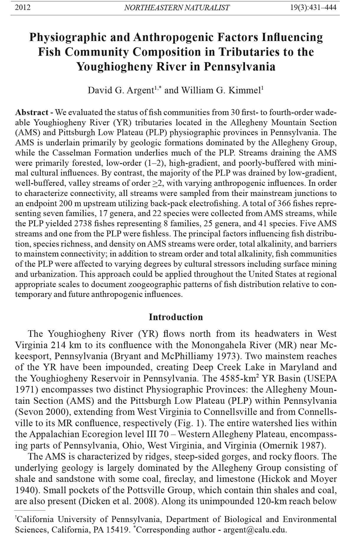
The Youghiogheny River (YR) flows north from its headwaters in West
Virginia 214 km to its confluence with the Monongahela River (MR) near Mckeesport,
Pennsylvania (Bryant and McPhilliamy 1973). Two mainstem reaches
of the YR have been impounded, creating Deep Creek Lake in Maryland and
the Youghiogheny Reservoir in Pennsylvania. The 4585-km2 YR Basin (USEPA
1971) encompasses two distinct Physiographic Provinces: the Allegheny Mountain
Section (AMS) and the Pittsburgh Low Plateau (PLP) within Pennsylvania
(Sevon 2000), extending from West Virginia to Connellsville and from Connellsville
to its MR confluence, respectively (fig. 1). The entire watershed lies within
the Appalachian Ecoregion level III 70 – Western Allegheny Plateau, encompassing
parts of Pennsylvania, Ohio, West Virginia, and Virginia (Omernik 1987).
The AMS is characterized by ridges, steep-sided gorges, and rocky floors. The
underlying geology is largely dominated by the Allegheny Group consisting of
shale and sandstone with some coal, fi reclay, and limestone (Hickok and Moyer
1940). Small pockets of the Pottsville Group, which contain thin shales and coal,
are also present (Dicken et al. 2008). Along its unimpounded 120-km reach below
!California University of Pennsylvania, Department of Biological and Environmental
Sciences, California, PA 15419. *Corresponding author - argent@calu.edu.
432 Northeastern Naturalist Vol. 19, No. 3
the Youghiogheny Reservoir, the YR is joined by a number of tributaries which
have been designated as High Quality Cold Water fisheries (HQ-CWF), Cold Water
fisheries (CW), or Exceptional Value (EV) by the Pennsylvania Department of
Environmental Protection (PA DEP) ( (PA Code 2001; WRAS 2001, 2003).
The PLP by contrast, consists of relatively shallow valleys with smooth, rolling
upland surfaces. The uplands are developed on rocks underlain by signifi cant
bituminous coal reserves contained within the Cassleman Formation and Monongahela
Group (Dicken et al. 2008). Tributaries draining the PLP include those
designated as Trout Stocking Waters (TSF) and Warm Water fisheries (WWF)
(PA Code 2001).
Deposits of bituminous coal within both the AMS and PLP were extensively
mined and subsequently abandoned, leaving a landscape of open pits and refuse
piles. Long after the cessation of active operations, a number of these sites continue
to pollute surface streams with acid (AMD) and net alkaline (NAMD) mine
drainage from point and non-point sources.
Acid mine drainage has resulted in widespread degradation of water quality
and impairment of aquatic communities throughout coal mining regions of the
northeastern United States. Hendricks (1980) stated that acidic coal mine drainage
and siltation are the most severe and limiting pollutants to aquatic organisms
in the YR. In addition, acid deposition (AD) throughout the Basin has negatively
impacted aquatic life in the poorly buffered HQ-CWF and EV streams that join
the YR from Chestnut Ridge and Laurel Hill (Kimmel 1999; Kimmel et al. 1996;
LeFevre and Sharpe 2002; Sharpe et al. 1985, 1987).
By the early 1950s, AMD had resulted in several major fi sh kills and a seemingly
lifeless river (Palmer 1984). Like the MR (Argent et al. 2007), the YR
figure 1. The YR Basin in Pennsylvania and locations of sampling stations.
2012 D.G. Argent and W.G. Kimmel 433
benefi tted from passage of environmental legislation and improving water quality;
however, the threats from its mining legacy remain. Periodic acid discharges
from tributaries like the Casselman River (Ziemkiewicz and Brant 1997) and
Cherry Creek (MDE 2003) serve as a reminder of the fragility of its recovery.
Over the years, the severity of acidifi cation throughout the YR Basin prompted
a number of local watershed groups and Chestnut Ridge Trout Unlimited to
acquire fi nancial support for a variety of mitigation projects (e.g., Laurel Hill
Creek Water Resources Plan, Glade Run Alkaline Sand Project, and Morgan Run
Acid Mine Remediation Project). While signifi cant funds have been expended to
ameliorate the effects of acidity within the Basin, long-term monitoring and bioassessment
have largely been absent.
The earliest published accounts of YR fi shes are those of Cooper (1983) from
collections made in the mid-1960s, and, more recently, those of Hendricks (1980)
and Hendricks et al. (1983), who documented 57 species from 172 stations across
Pennsylvania and Maryland. The Pennsylvania fish and Boat Commission also
maintains an unpublished database as part of its statewide stream-assessment
protocols. However, of the named Pennsylvania tributaries north of Confluence,
fewer than 10% have been sampled since the late 1970s, and no concerted effort
has been made to sample tributary/mainstem junctions (Argent et al. 1997).
Moreover, two fi sh species of conservation concern—Catostomus catostomus
(Forster) (Longnose Sucker), a YR endemic, and Pararhinichthys bowersi
(Goldsborough and Clark) (Cheat Minnow)—may be extant. Both are considered
critically imperiled by the state’s Natural Heritage Inventory and are listed as
species of “immediate concern” in Section 15.7 of Pennsylvania’s State Wildlife
Action Plan (PWAP 2005).
In 2008, the Pennsylvania Department of Conservation and Natural Resources
(DCNR) recognized the YR as its “River of the Year” (DiBerardinis 2008). Several
conservation plans have been developed for the YR Basin to ensure its continued
protection: “River Conservation Plan for the Middle Youghiogheny River Corridor”
and the “Youghiogheny Rivers Conservation Plan” (PA Bulletin 2001). Each
plan identifi es a need for the establishment of a monitoring network for the Basin
and an evaluation of aquatic fauna. Of particular interest are the tributaries, which
may serve as temporal refuges, breeding grounds, and nursery areas for fi sh, and as
sources of recolonizers for the YR concomitant with improving water quality.
The principal objectives of this study were to characterize fi sh communities
in wadeable tributary/mainstream junctions of the YR Basin and to identify
physiographic and anthropogenic factors which influence community structure.
The area of study encompassed named wadeable tributaries that join the YR over
its 120-km free-flowing reach downstream of the Youghiogheny Reservoir dam
from Confluence to McKeesport, PA (fig. 1).
Methods
We sampled 30 named wadeable YR tributaries, 13 and 17 on the AMS and
PLP, respectively, during May and June 2009. Major tributaries such as the
Casselman River and Laurel Hill Creek were not included in this survey because
their size and depth precluded comparable sampling effort with our selected
434 Northeastern Naturalist Vol. 19, No. 3
protocol (Kimmel and Argent 2006). A standard sampling distance beginning
just above the tributary/river confluence and extending 200 m upstream or to the
nearest blockage to fi sh passage comprised a sampling station. If no fi sh were
captured during the fi rst 100 m, electrofi shing was terminated. The midpoint of
each sampling station was identifi ed by GPS coordinates, and the total length (m)
and mean width (m) were determined. Streams were classifi ed by size using
Strahler (1952). Two-passes were employed to collect fi sh from each sampling
station, utilizing DC-pulsed back-pack electrofi shing gear (Kimmel and Argent
2006). In order to optimize and to standardize gear effi ciency, output was adjusted
according to local specifi c conductance to produce approximately 100–300
volts and draw 2–3 amps. Game fi shes and large specimens were identifi ed in
the fi eld and released. All others were fi xed in 10% formalin on-site, taken to
the laboratory at California University of Pennsylvania, and refrigerated for approximately
24 hr. All specimens were then preserved in 70% isopropyl alcohol
and identifi ed to the lowest practicable taxonomic level, typically species.
Measurements of temperature (oC), pH, and specifi c conductance (μS/cm)
were taken in the fi eld using a standard thermometer, pH Testr3+ (Oakton Instruments),
and a conductivity meter (YSI Model 33 S-C-T, Yellow Springs
Instruments), respectively. A 500-ml water sample was collected at each site and
brought to the laboratory for analysis of total alkalinity (mg/l as CaCO3) by titration.
Observable incidences of pollution (e.g., AMD, NAMD, and point sources
of raw or treated sewage effluent) were noted.
Because the YR Basin encompasses two distinct physiographic provinces and
associated geologic formations, we elected to evaluate our data by summarizing
fi sh community and water quality from each province separately. Employing
ArcGIS ver. 9.3 (ESRI 2008), we identifi ed the proportional contribution of the
respective geologic formations (PBTGS 1995) underlying each watershed.
We computed species richness and density (fi sh/m2) for fi sh collected from
each site. fish community metrics were compared with water quality parameters
and geologic data to defi ne patterns of fi sh distribution. Because collected
fi sh and water quality data did not meet the assumptions of normality, the nonparametric
Mann-Whitney U-test was utilized to determine if differences existed
between stations within the AMS and PLP. To evaluate the relationships between
fi sh community metrics (e.g., richness and density) and water quality/geology
variables, we used Spearman’s rank correlation. All statistical tests were evaluated
at a signifi cance level of P < 0.05.
Results/Discussion
Sampling-reach lengths ranged from 80 to 200 m, while mean widths ranged
from 2.1 to 23.8 m and stream orders were from 1–4 (Table 1). Although the PA
DEP designated use classifi cation (PA Code 2001) identifi es most all AMS and
PLP streams as CW or WWF, respectively (Table 2), stream temperatures at time
of sampling did not differ signifi cantly (Mann-Whitney U-test: P-value > 0.05;
Table 3). Likewise, pH values were not signifi cantly different between the two
physiographic regions (Mann-Whitney U-test: P-value > 0.05; Table 3). Total
alkalinity and specifi c conductance, both of which were signifi cantly higher in
2012 D.G. Argent and W.G. Kimmel 435
the PLP (Mann Whitney U-test: P-value < 0.05; Table 3), differentiate water
quality between the two physiographic regions. A total of 3104 fi shes were collected
from 24 of the 30 streams sampled. No signifi cant relationship existed
between area sampled and species richness or density (Spearman’s rank correlation:
P-value > 0.05). Neither Longnose Sucker nor Cheat Minnow were captured
during this survey.
Allegheny Mountain Section
The majority of AMS streams were fi rst or second order (Table 1) and drain
forested landscapes underlain largely by the Allegheny Group with local influences
from the Pottsville Group (Table 4). These exhibited depressed alkalinity
and specifi c conductance values accompanied by anomalous elevated pH readings
(Table 3). The pH and alkalinities documented here (Table 3) were not
predictable from the local geology (DeWalle et al. 1987), and no evidence of
Table 1. Stream orders and dimensions of sampling stations on YR tributaries draining the AMS
and PLP physiographic provinces in Pennsylvania. Streams are arranged in geographic order from
south to north within each physiographic province.
Stream Stream order Reach length (m) Mean reach width (m)
Allegheny Mountain streams
Hen Run 1 200 4.7
Ramcat Run 1 200 6.1
Camp Run 1 100 2.6
Lick Run 1 200 5.0
Cucumber Run 3 80 7.0
Meadow Run 4 200 12.5
Bear Run 2 100 5.5
Jonathan Run 2 100 7.7
Sugar Run 1 100 1.8
Bruner Run 1 200 5.9
Johnson Run 1 144 4.3
Morgan Run 2 200 10.0
Indian Creek 4 200 23.8
Pittsburgh Low Plateau streams
Dunbar Creek 3 200 11.6
Opossum Run 2 200 6.7
Mounts Creek 3 200 7.2
Galley Run 2 200 2.9
Hickman Run 2 100 2.1
Dickerson Run 2 200 5.4
Smiley Run 2 200 7.5
Washington Run 2 200 6.8
Browneller Run 2 200 3.4
Jacobs Creek 3 200 25.7
Furnace Run 2 200 2.2
Virgin Run 2 200 5.2
Cedar Creek 2 200 6.7
Sewickley Creek 4 200 21.5
Pollock Run 2 200 8.1
Douglas Run 2 200 9.0
Long Run 3 200 7.9
436 Northeastern Naturalist Vol. 19, No. 3
confounding cultural influences was observed. The local geology, mostly lacking
carbonate-bearing strata, would predict sub-neutral pH values associated with the
lack of buffering capacity. Alkalinity in surface streams is imparted to groundwater
flowing through deposits of carbonate minerals, typically limestone. In
well-buffered streams, aquatic life is protected from rapid pH change due to acid
inputs and benefi ts from nutrients associated with alkalinity. Values of baseflow
alkalinity identifi ed as less than 10 mg/l (Omernik 1983) and less than 20 mg/l as CaCO3, except
where natural conditions are less (PA Code 2001), are indicative of systems sensitive
to acidifi cation. Weiner (2000) further states that for protection of aquatic
life, the buffering capacity should be at least 20 mg/l. Therefore, these low-order
tributaries may be considered as extremely sensitive to acidifi cation. Three of the
AMS streams, Hen and Meadow runs and Indian Creek, are separated from the
rest on the basis on alkalinity and conductivity and, in the cases of Meadow Run
and Indian Creek, by size (3rd and 4th order, respectively).
A total of 366 fi shes representing 7 families, 17 genera, and 22 species were
collected here (Table 5). first- and second-order streams here were largely depauperate
(fig. 2) five fi rst-order streams were fi shless (Table 1, fig. 2), and of
these, Johnson and Cucumber runs contained impediments to fi sh passage that
prevented sampling over the prescribed 200-m reach (Table 1). Camp and Lick
runs, which harbored 0 and 3 fi shes, respectively, are underlain by 70% Pottsville
Group (Table 4), an acidic stratum (Sharpe et al. 1987). Overall, streams devoid
of fi sh and lacking impediments to passage exhibited alkalinity values ranging
from 4 to 10 mg/l, while those which yielded fi sh ranged from 2 to 10 mg/l total
alkalinity (Table 3, fig. 2).
Table 2. Designated uses of AMS and PLP tributaries to the YR in Pennsylvania. Streams are arranged
in geographic order from south to north.
Allegheny Mountain Pittsburgh Low Plateau
streams Designated use* streams Designated use*
Hen Run CWF Dunbar Creek TSF
Ramcat Run CWF Opossum Run WWF
Camp Run HQ-CWF Mounts Creek WWF
Lick Run HQ-CWF Galley Run WWF
Cucumber Run CWF Hickman Run WWF
Meadow Run HQ-CWF Dickerson Run WWF
Bear Run EV Smiley Run WWF
Jonathan Run EV Washington Run WWF
Sugar Run EV Browneller Run WWF
Bruner Run EV Jacobs Creek WWF
Johnson Run HQ-CWF Furnace Run WWF
Morgan Run HQ-CWF Virgin Run TSF
Indian Creek HQ-CWF Cedar Creek TSF
Sewickley Creek WWF
Pollock Run WWF
Douglas Run WWF
Long Run TSF
*PA DEP Designated Use: CWF = Coldwater fishery, EV = Exceptional Value, HQ-CWF = High
Quality Coldwater fishery, TSF = Trout Stocking fishery, and WWF = Warmwater fishery.
2012 D.G. Argent and W.G. Kimmel 437
Twelve of the 13 AMS streams are located within the confi nes of Ohiopyle
State Park (fig. 1) and classifi ed as either EV or HQ-CWF. The dominant geological
formation is the Allegheny Group, ranging from 0–99% coverage (Table 4),
with the proportion of Glenshaw Formation (Table 4) a modest predictor of
species richness (non-linear regression: P-value < 0.05, R2 = 0.50). fish associations,
depauperate in species richness and density where present, were typically
located within the fi rst 20 m of a sampling reach. Such “remnant” or “transient”
communities have been described from poorly buffered streams on nearby Laurel
Hill as a result of AD (Sharpe et al. 1987). Studies by Haines (1981), Sharpe et
al. (1985), and others reported episodic acidifi cation associated with high flows
during snowmelt, which may depress pH values and elevate dissolved aluminum
concentrations to levels toxic to fi sh.
Among streams within the AMS, Hen Run, Meadow Run, and Indian Creek
exhibited the highest values of total alkalinity, specifi c conductance (Table 3),
Table 3. Selected water quality parameters of AMS and PLP streams. Streams are arranged in geographic
order from south to north within each physiographic province.
Conductivity Alkalinity
Stream Temperature (oC) pH (μS/cm) (mg/l)
Allegheny Mountain streams
Hen Run 9.0 8.70 80 16
Ramcat Run 9.0 8.50 25 4
Camp Run 9.2 8.80 60 8
Lick Run 10.3 9.03 38 8
Cucumber Run 10.0 8.20 55 10
Meadow Run 17.0 7.60 150 24
Bear Run 11.9 8.79 40 6
Jonathan Run 9.6 9.15 73 4
Sugar Run 9.2 8.75 44 10
Bruner Run 10.0 8.50 50 4
Johnson Run 10.5 8.54 54 14
Morgan Run 15.0 7.70 185 2
Indian Creek 19.5 7.70 240 16
Pittsburgh Low Plateau Streams
Dunbar Creek 17.5 8.20 160 34
Opossum Run 14.5 8.70 405 150
Mounts Creek 15.7 8.56 264 54
Galley Run 12.0 7.00 700 56
Hickman Run 9.0 6.10 600 4
Dickerson Run 10.0 8.60 470 150
Smiley Run 12.5 8.10 175 34
Washington Run 11.5 8.80 420 138
Browneller Run 12.0 8.90 435 220
Jacobs Creek 13.0 8.40 340 52
Furnace Run 17.0 7.90 223 68
Virgin Run 20.0 8.50 160 48
Cedar Creek 10.0 8.90 500 224
Sewickley Creek 19.0 8.50 800 136
Pollock Run 8.0 8.80 500 234
Douglas Run 7.0 7.90 700 236
Long Run 11.2 8.30 700 130
438 Northeastern Naturalist Vol. 19, No. 3
Table 4. Geologic strata expressed as percent contribution within the AMS. Streams are arranged
in geographic order from south to north.
Allegheny Glenshaw Pottsville Burgoon
Stream Group Formation Group Sandstone
Hen Run 93 7 0 0
Ramcat Run 91 7 2 0
Camp Run 0 0 70 10
Lick Run 0 0 70 10
Cucumber Run 99 1 0 0
Meadow Run 98 1 1 0
Bear Run 97 0 3 0
Jonathan Run 98 2 0 0
Sugar Run 99 0 1 0
Bruner Run 97 2 1 0
Johnson Run 99 0 1 0
Morgan Run 97 1 1 0
Indian Creek 81 17 1 0
Table 5. Ichthyofauna collected from one or more YR tributaries draining the AMS and PLP in
Pennsylvania.
Family/common name Scientifi c name AMS PLP
Salominidae
Brook Trout Salvelinus fontinalis Mitchill 6 2
Rainbow Trout Oncorhynchus mykiss (Waldbaum) 3 1
Brown Trout Salmo trutta L. 2
Cyprinidae
Central Stoneroller Campostoma anomalum (Rafi nesque) 1 174
Striped Shiner Luxilus chrysocephalus Rafi nesque 1
Common Shiner Luxilus cornutus (Mitchill) 5
Spotfi n Shiner Cyprinella spiloptera (Cope) 31
River Chub Nocomis micropogon (Cope) 57 1
Golden Shiner Notemigonus crysoleucus (Mitchill) 4
Emerald Shiner Notropis atherinoides Rafi nesque 66
Sand Shiner Notropis stramineus (Cope) 4
Rosyface Shiner Notropis rubellus (Agassiz) 3 40
Mimic Shiner Notropis volucellus (Cope) 606
Channel Shiner Notropis wickliffi Trautman 5
Shiner sp. Notropis sp. 7
Bluntnose Minnow Pimephales notatus (Rafi nesque) 2 285
Fathead Minnow Pimephales promelas Rafi nesque 1 21
Blacknose Dace Rhinichthys atratulus (Hermann) 58 112
Longnose Dace Rhinichthys cataractae (Valenciennes in Cuvier 52 11
and Valenciennes)
Creek Chub Semotilus atromaculatus (Mitchill) 15 204
Catostomidae
White Sucker Catostomus commersoni (Lacépède) 3 120
Northern Hogsucker Hypentelium nigricans (Lesueur) 7 104
Black Redhorse Moxostoma duquesnei (Lesueur) 2
Golden Redhorse Moxostoma erythrurum (Rafi nesque) 8
Ictaluridae
Brown Bullhead Ameiurus nebulosus (Lesueur) 10
Yellow Bullhead Ameiurus natalis (Lesueur) 2
Stonecat Noturus flavus Rafi nesque 10
2012 D.G. Argent and W.G. Kimmel 439
species richness, and density (fig. 3). These streams are underlain by 81–99%
Allegheny Group (Table 4). Only Hen Run harbored native Salvelinus fontinalis
(Brook Trout), while Ameiurus nebulosus (Brown Bullhead) was collected only
from Meadow Run. Indian Creek yielded 57 of the 58 Nocomis micropogon
(River Chub) captured. Together, these three streams accounted for 76% of the
total number of fi shes and 77% of overall species richness (fig. 3).
The paucity of fi shes within the low-order tributaries draining the AMS
(Table 1, fig. 3) may be indicative of historical and/or current episodic acidifi cation
resulting from low buffering capacity, stream order, thermal preference, and/
or or obstacles to riverine connectivity. The near total absence of Brook Trout is
noteworthy, as these streams fall within the expected geographic range of this species
in the forested cold-water environments designated for its special protection
by the PA DEP (e.g., EV and HQ-CW; PA Code 2001). Along with vulnerability to
acidifi cation, coldwater species here may also be vulnerable to modest increases in
temperature as predicted from several climate change models (Eaton and Sheller
1996). Further, issues of watershed connectivity may exist as a result of natural
barriers to passage such as waterfalls and log jams as well as culverts under the
YR Trail. Stations within the AMS that yielded no fi sh in 2009 were resampled
in 2010 along their designated reach and an additional 100-m reach upstream of
their impediments to fi sh passage. Low numbers of Rhinichthys atratulus (Blacknose
Dace), Rhinichthys cataractae (Longnose Dace), and Cottus bairdi (Mottled
Table 5, continued.
Family/common name Scientifi c name AMS PLP
Centrarchidae
Rock Bass Ambloplites rupestris (Rafi nesque) 23
Green Sunfi sh Lepomis cyanellus Rafi nesque 1 48
Pumpkinseed Lepomis gibbosus (L.) 10
Bluegill Lepomis macrochirus Rafi nesque 4 60
Sunfi sh Hybrid Lepomis hybrid 1
Smallmouth Bass Micropterus dolomieui Lacépède 14 33
Largemouth Bass Micropterus salmoides (Lacépède) 1
Spotted Bass Micropterus punctulatus (Rafi nesque) 1
Black Crappie Pomoxis nigromaculatus (Lesueur) 1
Percidae
Greenside Darter Etheostoma blennioides Rafi nesque 2 180
Rainbow Darter Etheostoma caeruleum Storer 339
Fantail Darter Etheostoma flabellare Rafi nesque 15 55
Johnny Darter Etheostoma nigrum Rafi nesque 2
Banded Darter Etheostoma zonale (Cope) 50
Yellow Perch Perca flavescens (Mitchill) 2 3
Logperch Percina caprodes (Rafi nesque) 1
Darter Hybrid Percina sp. 1
Scianidae
Freshwater Drum Aplodinotus grunniens Rafi nesque 2
Cottidae
Mottled Sculpin Cottus bairdi Girard 106 70
Slimy Sculpin Cottus cognatus (Richardson) 33
Total 366 2738
440 Northeastern Naturalist Vol. 19, No. 3
Sculpin) were collected near each mainstem confluence, suggesting the presence
of transient associations derived from the mainstem.
Pittsburgh Low Plateau section
Valley streams here, second to fourth order (Table 1) and influenced by a
variety of anthropogenic factors, are designated as WWF or TSF by the PA DEP
(PA Code 2001; Table 2). All but Hickman Run exhibited concomitant elevated
values of total alkalinity, pH, and specific conductance (Table 3). These values
are consistent with the presence of the Monongahela Group and Glenshaw Formations,
which frequently contains deposits of limestone, within the underlying
geology (Table 6). A total of 2738 fishes representing 8 families, 25 genera, and
41 species were collected from PLP streams (Table 5). Although cultural influences
such as AMD, NAMD, and untreated/treated sewage discharges impact
a number of streams here, fish community species richness and density greatly
exceeded those of the AMS (Mann-Whitney U-test: P-value < 0.05). Hickman
Run was the only stream that yielded no fish (fig. 2), a likely consequence of
persistent raw sewage observed in the field. Historically, both Galley Run and
Sewickley Creek were impacted by AMD. However, a comprehensive remediation
strategy implemented on Sewickley Creek (Capacasa 2009) has initiated
a recovery that is evidenced by its high species richness (fig. 2); Galley Run,
currently impacted by NAMD, exhibits higher species richness and density than
most AMS streams (fig. 2).
figure 2. A comparison of fi sh species richness and density among YR tributaries draining
the PLP in Pennsylvania. Bars denote species richness, and black squares denote density.
2012 D.G. Argent and W.G. Kimmel 441
figure 3. A comparison of fi sh species richness and density among YR tributaries draining
the AMS in Pennsylvania. Bars denote species richness, and black squares denote density.
Table 6. Geologic strata expressed as percent composition within the PLP. Streams are arranged in
geographic order from south to north.
Allegheny Casselman Glenshaw Monongahela
Stream Group Formation Formation Group
Dunbar Creek 47 9 43 0
Opossum Run 0 0 0 75
Mounts Creek 44 12 43 1
Galley Run 0 92 0 8
Hickman Run 0 92 0 8
Dickerson Run 0 89 0 7
Smiley Run 0 100 0 0
Washington Run 0 20 61 18
Browneller Run 0 53 0 47
Jacobs Creek 0 23 70 6
Furnace Run 9 48 43 0
Virgin Run 0 81 13 5
Cedar Creek 0 0 0 99
Sewickley Creek 0 22 56 22
Pollock Run 0 53 0 47
Douglas Run 0 53 0 47
Long Run 0 62 0 37
442 Northeastern Naturalist Vol. 19, No. 3
The combination of alkalinity, stream size (Karr 1981), and riverine connectivity
likely account for the increased species richness and density over those
of AMS streams (fig. 2). Along with buffering capacity, alkalinity is associated
with increased secondary biological productivity (Death and Winterbourn 1995,
Rahel 1986). However, the presence of the Casselman Formation in excess of
30% negatively affected species richness for most streams here (Spearman’s
Rank Correlation: P-value < 0.05, r = -0.52). The role of connectivity among PLP
streams may also be a contributor to diversity and density, as no stream contained
a barrier to fi sh passage within 200 m of its YR confluence (Table 1).
Summary
This study represents the first comprehensive survey of YR tributary fish
associations at their mainstream/tributary junctions. Historically, the YR
was severely impacted by AMD, but now supports a significant recreational
fishery as a result of a comprehensive mitigation strategy. The two physiographic
provinces traversed by the River are drained by streams very different
in their underlying geology, water quality, size, cultural influences, and ichthyofauna.
The low-order forested AMS streams are characterized by poor
buffering capacity, low conductivity, and anomalous elevated values of pH.
The ichthyofauna here is depauperate in species richness and density, with 5
of the 13 tributaries being fishless, although all are afforded special protection
as cold-water fisheries. Further, only one stream supported Brook Trout. Major
threats to these fragile streams and their remnant fish populations include
acid deposition and impediments to mainstream connectivity. By contrast, the
larger valley streams of the PLP are well-buffered, and in spite of a variety of
pollutants, overall support a healthy and diverse ichthyofauna. The AMS and
PLP tributaries represent geologically distinct components of the YR river
basin in spite of their geographic proximity, and highlight the need for comprehensive
watershed surveys. Conservation of biological resources depends
upon focused management strategies in light of threats that, in turn, require
accurate and timely inventories of faunal associations along with their spatial
distributions. Such is the case with expanding natural gas development from
the Marcellus and Utica formations which underlie large portions of Pennsylvania
(including the YR Basin), West Virginia, New York, Kentucky, and
Ohio. Tributary/mainstream junction surveys on large watersheds such as this
provide baseline information on water quality and ichthyofaunal communities
against which future degradations can be assessed.
Acknowledgments
We wish to thank the PA Wild Resource Conservation Fund for providing fi nancial
support for this survey (WRCP Grant #08289) and Michael Brady, Michael McCoy,
Carlyle Meekins, and Mark Novak, fi eld technicians. Andrew Saint John and Barbara
Wallace from the PA Department of Conservation and Natural Resources assisted with
stream access and permitting.
2012 D.G. Argent and W.G. Kimmel 443
Literature Cited
Argent, D.G., R.F. Carline, and J.R. Stauffer, Jr. 1997. Historical and contemporary
distribution of fi shes in Pennsylvania Technical Report. RWO - 47. USGS Biological
Resources Division, University Park, PA. 278 pp.
Argent, D.G., W.G. Kimmel, R. Lorson, and E. Emery. 2007. Ichthyofauna of the Monongahela
River Basin in Pennsylvania: A contemporary evaluation. Journal of Freshwater
Ecology 22:617–628.
Bryant, G., and S. McPhilliamy. 1973. Water quality assessment report: Monongahela
River Basin. US EPA, Region II, Wheeling Offi ce, WV. 18 pp.
Capacasa, J.M. 2009. Decision rationale total maximum daily loads for acid mine drainage
affected segments Sewickly Creek Watershed TMDL, Westmoreland County,
Pennsylvania. US Environmental Protection Agency, Philadelphia, PA. 10 pp.
Cooper, E.L. 1983. The fishes of Pennsylvania and the Northeastern United States. The
Pennsylvania State University Press, University Park, PA. 243 pp.
Death, R.G., and M.J. Winterbourn 1995. Diversity patterns in stream benthic invertebrate
communities: The influence of habitat stability. Ecology 76:1446–1460.
DeWalle, D.R., R.S. Dinicola, and W.E. Sharpe. 1987. Predicting baseflow alkalinity as
an index to episodic stream acidifi cation and fi sh presence. Journal of the American
Water Resources Association 23:29–35.
DiBerardinis, M. 2008. Pennsylvania Department of Conservation and Natural Resources
press conference. Harrisburg, PA. 18 March 2008.
Dicken, C.L., S.W. Nicholson, J.D. Horton, S.A. Kinney, G. Gunther, M.P. Foose, and
J.A.L. Mueller. 2008. Preliminary integrated geologic map databases for the United
States: Delaware, Maryland, New York, Pennsylvania, and Virginia. Available online
at http://pubs.usgs.gov/of/2005/1325/. Accessed 1 March 2011.
Eaton, J.G., and R.M. Scheller. 1996. Effects of climate warming on fi sh thermal habitat
in streams of the United States. Limnology and Oceanography 41:1109–1115.
ESRI 2008. ArcGIS Desktop: Release 9.3. Environmental Systems Research Institute.
Redlands, CA. 600 pp.
Haines, T.A. 1981. Acidic precipitation and its consequences for aquatic ecosystems: A
review. Transactions of the American fisheries Society 110: 669–707.
Hendricks, M.L. 1980. The distribution of fi shes of the Youghiogheny River. M.Sc. Thesis.
Frostburg State College, Frostburg, MD. 216 pp.
Hendricks, M.L., J.R. Stauffer, Jr., and C.H. Hocutt. 1983. The zoogeography of fi shes of
the Youghiogheny River system, Pennsylvania, Maryland, and West Virginia. American
Midland Naturalist 110(1):145–164.
Hickok, W.O. IV, and F.T. Moyer. 1940. Geology and mineral resources of Fayette
County, Pennsylvania. Pennsylvania Geological Survey County Report 26. Harrisburg,
PA. 530 pp.
Karr, J. 1981. Assessment of biotic integrity using fi sh communities. fisheries 6:21–27.
Kimmel, W.G. 1999. Macroinvertebrate community responses to episodic stream acidifi
cation on the Laurel Hill in Southwestern Pennsylvania. Pp. 17–22, In W.E. Sharpe
and J.R. Drohan (Eds.). The Effects of Acidic Deposition on Aquatic Ecosystems in
Pennsylvnaia. Proceedings of the 1998 PA Acidic Deposition Conference, Vol. II.
Environmental Resources Research Institute, University Park, PA. 61 pp.
Kimmel, W.G., and D.G. Argent. 2006. Effi cacy of two-pass electrofi shing employing
multiple units to assess stream fi sh species richness. fisheries Research 82:14–18.
Kimmel, W.G., E.L. Cooper, and C.C. Wagner. 1996. Macroinvertebrate and fi sh populations
of four streams receiving high rates of hydrogen and sulfate ion deposition.
Journal of Freshwater Ecology 11:493–511.
LeFevre, S.R., and W.E. Sharpe. 2002. Acid stream water remediation using limestone
sand on Bear Run in southwestern Pennsylvania. Restoration Ecology 10:223–236.
444 Northeastern Naturalist Vol. 19, No. 3
Maryland Department of the Environment (MDE). 2003. Total maximum daily loads to
address low pH in Cherry Creek in the Deep Creek Watershed, Garrett County, Maryland.
Montgomery Business Park Center, Baltimore, MD. 27 pp.
Omernik, J.M. 1983. Total alkalinity of surface waters: A national map. Annals of the
Association of American Geographers 73:133–136.
Omernik, J.M. 1987. Ecoregions of the conterminous United States. Annals of the Association
of American Geographers 77:118–125.
Palmer, T. 1984. Youghiogheny: Appalachian River. University of Pittsburgh Press,
Pittsburgh, PA. 352 pp.
Pennsylvania (PA) Bulletin. 2001. Department of Conservation and Natural Resources
notices: Middle Youghiogheny River Corridor Conservation Plan. 31:6523–6646.
Pennsylvania Bureau of Topographic and Geologic Survey (PBTGS). 1995. Physiographic
provinces 1:100,000. Department of Conservation and Natural Resources.
Harrisburg, PA.
Pennsylvania (PA) Code. 2001. Title 25. Environmental Protection – Chapter §93. Department
of Environmental Protection, Bureau of Water Supply, Harrisburg, PA. 280 pp.
Pennsylvania’s Wildlife Action Plan (PWAP). 2005. Pennsylvania’s Wildlife Action
Plan: Version 1.0a. Compiled and edited by the Pennsylvania Game Commission and
Pennsylvania fish and Boat Commission, Harrisburg, PA. 762 pp.
Rahel, F. 1986. Biogeographic influences on fi sh species composition of northern Wisconsin
lakes with applications for lake acidifi cation studies. Canadian Journal of
fisheries and Aquatic Sciences 43:124–134.
Sevon, W.D. 2000. Physiographic provinces of Pennsylvania. Pennsylvania Department
of Conservation and Natural Resources, Bureau of Topographic and Geologic Survey,
Harrisburg, PA. 4th Series, Map 13, scale 1:2,000,000.
Sharpe, W.E., D.R. DeWalle, R.T. Leibfried, R.S. Dinicola, W.G. Kimmel, and L.S.
Sherwin. 1985. Causes of acidifi cation of four streams on Laurel Hill in southwestern
Pennsylvania. Journal of Environmental Quality 13:3619–631.
Sharpe, W.E., V.G. Leibfried, W.G. Kimmel, and D.R. DeWalle. 1987. The relationship of
water quality and fi sh occurrence to soils and geology in an area of high hydrogen and
sulfate ion deposition. Journal of American Water Resources Association 23:37–46.
Strahler, A.N. 1952. Dynamic basis of geomorphology. Geological Society of America
Bulletin 63:923–938.
US Enviornmental Protection Agency (USEPA). 1971. A report on pollution of the Ohio
River and its tributaries in Pittsburgh, Pa., area. USEPA Region III, Cincinnati, OH.
93 pp.
Watershed Restoration Action Strategy (WRAS). 2001. State Water Plan Subbasin 19D.
Lower Youghiogheny River Watershed, Westmoreland and Fayette counties. DEP
Bureau of Watershed Management, Harrisburg, PA. 8 pp.
WRAS. 2003. State Water Plan Subbasin 19E. Upper Youghiogheny River Watershed,
(Laurel Hill Creek and Indian Creek), Fayette, Somerset, and Westmoreland counties.
DEP Bureau of Watershed Management, Harrisburg, PA. 13 pp.
Weiner, E.R. 2000. Applications of Environmental Chemistry: A Practical Guide for Environmental
Professionals. CRC Press LLC, Boca Raton, FL. 456 pp.
Ziemkiewicz, P.F., and D.L. Brant. 1997. The Casselman River restoration project. West
Virginia Surface Mine Drainage Task Force Symposium, Morgantown, WV, April
15–16, 1997. National Mine Land Reclamation Center, Morgantown, WV.

