2012 NORTHEASTERN NATURALIST 19(3):487–500
Near-shore fish Populations within St. Pauls Inlet,
an Estuarine System in Western Newfoundland
Ryan L. Melanson1 and Christine E. Campbell1,*
Abstract - St. Pauls Inlet, a fjord-type estuary on Newfoundland’s west coast, was sampled
for near-shore fi sh populations during August 2010. A total of 1451 fi sh were caught,
comprising 15 species and representing nine families. Sampling was carried out using a
10-m beach seine, minnow traps, and multi-paneled gill nets. The objective of this study
was to document the near-shore fi sh fauna within St. Pauls Inlet and compare with other
data sets from Newfoundland and Labrador. A total of seven sites were sampled along the
Inlet and the outer bay. Sites were chosen to best represent a potential range in salinities,
and for ease of accessibility. Cluster analysis performed on species presence/absence
data indicated high similarity between sites based on the Jaccard similarity coeffi cient. In
terms of regional fi sh fauna, the St. Pauls sites clustered with freshwater-influenced sites
from Bonne Bay (western Newfoundland), and were distinct from the more marine sites
of Trinity Bay (eastern Newfoundland) and Gilbert Bay (Labrador).
Introduction
St. Pauls Inlet, located on the west coast of insular Newfoundland, represents
a transition zone between temperate and arctic environments and has been designated
as a marine area of interest by the Canadian Parks and Wildlife Society
(Rao et al. 2009). The Inlet lies at the northern boundary of Gros Morne National
Park. An initial study of the physical, chemical, and biological resources of the
Inlet was conducted during the summer and fall of 1977 and spring 1978 as part
of the process of surveying aquatic ecosystems in the then newly proposed national
park. This survey by Carter and MacGregor (1979) suggested moderate
near-shore fi sh diversity, with 23 species identifi ed. No studies of fi sh populations
in the Inlet have been conducted since that time. Based on physical subtidal
surveys, dredge samples, and aerial photographs, Carter and MacGregor (1979)
found that St. Pauls Inlet contained many subtidal habitats in a small area, potentially
leading to a high density of diverse fi sh communities. In the past (1874 to
1970), the Inlet has supported a lobster and herring fi shery (Kudac et al. 2009).
By the late 1970s, the herring fi shery had collapsed, while the lobster population
currently supports only a small fi shery of 12 fi shers (Kudac et al. 2009). Spawning
habitat for herring still exists within the Inlet, which could be essential in
reviving a sustainable fi shery in the future (Rao et al. 2009).
Information on fi sh populations within the Inlet could prove useful in efforts
to aid in the recovery of stocks and potentially inform community stakeholders.
Despite the ecological, economic, and social importance of St. Pauls Inlet to the
1Environmental Science, Grenfell Campus, Memorial University of Newfoundland, Corner
Brook, NL, Canada A2H 6P9. *Corresponding author - ccampbell@grenfell.mun.ca.
488 Northeastern Naturalist Vol. 19, No. 3
local region, however, there has been a lack of scientifi c study conducted in the
area within the last 30 years. As such, this study’s objective is to assess the fi sh
assemblage currently present within the Inlet and to make regional comparisons
with published studies (Currie et al. 2009, Methven et al. 2001, Wroblewski et
al. 2007). Comparisons can also be made with Carter and MacGregor (1979)
in order to examine possible temporal changes in the fi sh species composition
within St. Pauls Inlet. Assessment of the fi sh assemblages in an area is crucial
to understanding future spatial and temporal variation in response to a shifting
environmental conditions such as climate change (Gomes et al. 1995). Assemblages
in estuaries are particularly important to understand as estuaries are highly
dynamic and often characterized by abrupt environmental changes in temperature,
salinity, or oxygen content (Methven et al. 2001, Pritchard 1967).
This project is part of a larger Memorial University of Newfoundland’s
(MUN) Community-University Research for Recovery Alliance (CURRA) research
program that focuses on the importance of fi sheries to communities in
western Newfoundland (http://www.curra.ca).
Methods
field-site description
St. Pauls Inlet can be considered to be an estuary as defi ned by Pritchard
(1967) because it is a semi-enclosed body of water that has a degree of free connection
with the open sea and is measurably diluted with fresh water derived
from land drainage. St. Pauls is an example of a fjord-like estuary, as bathometry
mapping reveals a steep-walled, U-shaped basin with glacial moraine near the
inlet’s mouth. The physical environment of coastal western Newfoundland refl
ects recent glaciations that occurred approximately 12,000 years ago (Rogerson
1983) and caused formation of fjord-like valleys. The Inlet is located near the
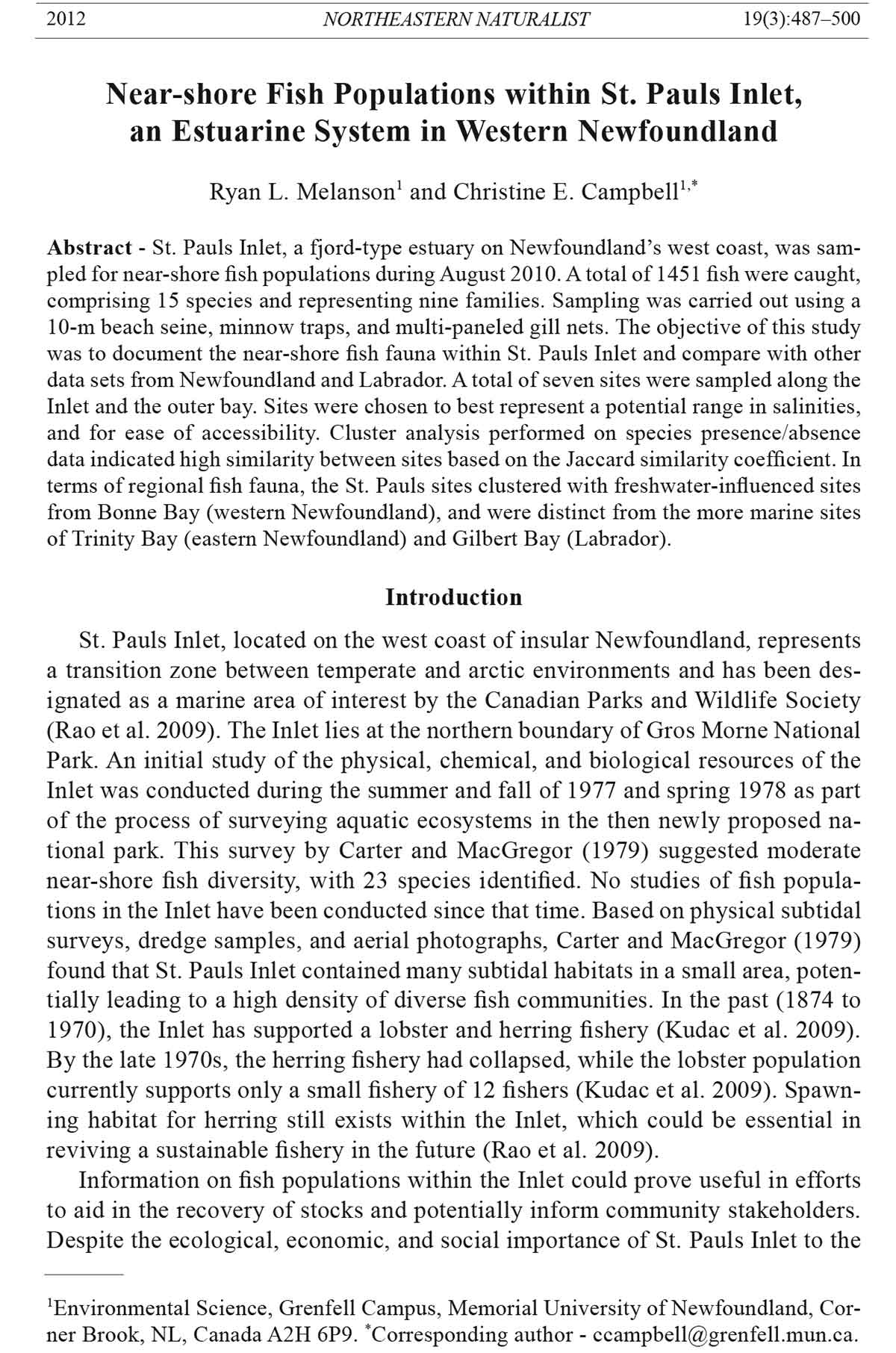
northern limit of Gros Morne National Park (fig. 1A). The Park envelops a large
portion of the land surrounding the fjord-like inlet as well as a signifi cant portion
of the waters, but does not encompass the entire inlet. St. Pauls Inlet is 11 km in
length, with width ranging from 6 km at its widest point in the west and tapering
to approximately 1 km wide at the eastern tail (Carter and MacGregor 1979).
The surface area of the inlet is approximately 30 km2. The only brackish water
body found within the confi nes of the Park, St. Pauls Inlet is fed by 24 tributaries
(O’Sullivan 1976) and connected to St. Pauls Bay by a restricted opening
that is approximately 80 m wide and 6 m deep. The largest input of fresh water
is Bottom Brook at the eastern end of the inlet (O’Sullivan 1976). The inlet is
characterized by shallow depths of 1–3 m towards the western portion extending
into the bay. The eastern portion of the Inlet is steeply sloped, descending to a
maximum depth of 36 m at the center. The coastline within St. Pauls Inlet is composed
of substrate formed from glacial scouring, resulting in a variety of steeply
sloping rocky beaches as well as shallow and coarse sandy beaches (Carter and
MacGregor 1979). The village of St. Paul’s is situated between the inlet and the
2012 R.L. Melanson and C.E. Campbell 489
more marine St. Pauls Bay. The bay, which opens into the Gulf of St. Lawrence, is
characterized by shallow water less than 3 m deep and sand bars with occasional
rocky shores.
Diversity of fi sh species in St. Pauls Inlet can be compared with diversity data
from other areas in Newfoundland and Labrador in order to place St. Pauls in a
more regional context. These areas include Bonne Bay (Currie et al. 2009), Gilbert
figure 1. Map of fi eld sites: (A) The 7 study sites within St. Pauls Inlet; (B) Location
of St. Pauls Inlet relative to Bonne Bay, Gilbert Bay, and Trinity Bay, highlighting the
location of Gros Morne National Park. Note that St. Pauls Bay opens out directly into the
Gulf of St. Lawrence.
490 Northeastern Naturalist Vol. 19, No. 3
Bay (Wroblewski et al. 2007), and Trinity Bay (Methven et al. 2001). Bonne Bay,
a marine fjord system composed of three arms, is located approximately 40 km
south of St. Pauls Inlet, within Gros Morne National Park. This body of water
contains an estuarine portion near two large fresh water inputs: Deer Brook and
Lomond River. The more northerly Gilbert Bay is a sub-arctic shallow fjord with
the characteristics of an estuary. The Gilbert River and Shinneys River flow into
this bay, which is located in southeastern Labrador and may contain arctic fi sh
in their southernmost range (Wroblewski et al. 2007). Trinity Bay (Bellevue) is
an estuarine environment located on the east coast of Newfoundland. It is flat,
protected from waves, and has a substrate of silt accumulating on rock (Methven
et al. 2001).
field sampling
Sampling took place from 2 August to 28 August 2010. A total of seven sites
were sampled: 6 within St. Pauls Inlet and 1 location along St. Pauls Bay (fig.
1A). Sites were chosen to represent a potential range in salinities and substrate
type (Table 1), and for their ease of accessibility. Site 1 was in the more saline
bay habitat, closest to the marine environment of the Gulf of St. Lawrence. This
region of the Gulf, called the Esquiman Channel, ranges in salinity from 32–36
ppt (Galbraith 2006). Site 2 was selected to examine the transition from the bay
into the inlet as defi ned by the restricted opening and a strong tidal influence.
Sites 3–7 were chosen in order to sample over the possible salinity range within
the Inlet, ranging from marine conditions near the bay, to a potentially greater
freshwater influence nearest the eastern portion at Bottom Brook. Due to logistical
constraints (e.g., wind on the inlet was strong and often prohibited travel),
sites farthest from the town of St. Paul’s were not sampled as frequently as were
sites in closer proximity. Supplementary sub-sites were set at some locations
to complement the main site and more comprehensively sample the fi sh fauna.
Table 1. Benthic substrate type, water column salinity, temperature (as measured at 1 m depth), and
gear type used at the 7 sampling sites in St. Pauls Inlet. Gear refers to beach seine (BS), minnow
traps (MT) and gill nets (GN). C&M = Carter and MacGregor (1979).
Site Substrate type Mean salinity Temperature (oC) Gear
1 Sand 21 18 BS, MT
2 Exposed bedrock 24 22 BS, MT
3A Sand 21 22 MT
3B Sand 21 22 MT
3C Sand 20 22 MT
4 Boulders 24 22 BS, MT
5 Boulders 13 19 MT
6A Boulders 21 22 BS
6B Gravel with mud 22 19 MT
7A Sand 18 21 BS
7B Sand 19 20 BS, GN
7C Boulders 17 20 BS,GN
C&M Various sites BS,GN
2012 R.L. Melanson and C.E. Campbell 491
Salinity (ppt) and water temperature (°C) were recorded at every sampling location
using a YSI model 85 probe.
The main aim of the sampling was to generate qualitative data on the species
composition of the near-shore fish fauna. Accordingly, multiple gear types
were utilized: 10-m beach seine, minnow traps, and multi-paneled gill nets
(Table 1), similar to methods employed by Carter and MacGregor (1979), Currie
et al. (2009), Methven et al. (2001), and Wroblewski et al. (2007). Multiple
gear types were used since size selectivity can differ substantially between gear
types (Methven and Schneider 1998). Not all sites were sampled with the same
gear types as the substrates at some locations did not permit their use. The seine
was comprised of a 10-m by 1.5-m panel, with 10-mm stretch-mesh netting.
The seine was hauled perpendicular to the shoreline by two people wearing
chest waders in water no deeper than 1.5 m. A tow length ranging from 10–50 m
was selected based on an initial survey of a site, with catch per unit effort data
later standardized per tow length and number of tows. For each sampling date,
at least 2 tows were done at each site up to a maximum of 5 tows. Sites 7B and
7C were sampled on 2 dates with the beach seine, while Sites 1, 2, 4, 6A,
and 7A were sampled once. The other sites did not permit the use of the beach
seine due to large obstructing boulders. The minnow traps were deployed approximately
5 to 10 m from shore, fully submerged beneath the water. Each trap
was baited with a cup of dry dog food and anchored to the shore by a tether and
weight. Traps were standard funnel design, 44 cm long by 23 cm wide, with 0.6-
cm mesh. Trapping was done on 9 occasions, with traps typically set in the early
morning and retrieved in the afternoon. Due to inclement weather on two occasions,
traps were left overnight to be retrieved early the next day. Traps were set
at 50–150-m intervals along the shoreline, depending on the sampling location,
with catch per unit data later standardized per number of traps and total hours
set. Gill nets were only used once (due to logistical constraints), on August 15,
and only at sites 7B and 7C (having appropriate depths for deployment). The
nets were deployed from a small boat and were laid out perpendicular to shore,
with the lower end of the net set close to the substrata. Two multi-mesh gill nets
were used, one consisting of 9 panels with increasing mesh sizes per panel (19,
24, 38, 51, 64, 76, 89, 101, 114 mm mesh stretch sizes) and the other consisting
of 8 panels with the 76-mm mesh stretch panel excluded. Each panel was
15 m in length and 2.5 m in height. Total length of the 9-panel net was 135 m;
the 8-panel net was 120 m in length. Each gill net was set for 3 hours, for a total
of 6 hours sampling time.
In the previous survey of the inlet, Carter and MacGregor (1979) sampled in
the summer and fall of 1977 primarily using gill nets left out overnight (5-panel
net, each panel 6 m long, mesh size from 12 to 88 mm, total of 200 hours operation
time) with some daytime beach seining (10-m by 1.3-m seine with 4-mm
mesh). They set out gill nets at 9 sites, including Site 7C that was sampled in
2010; beach seining was done at 4 sites corresponding to the 2010 sites of 6B,
7A, 7B, and 7C.
492 Northeastern Naturalist Vol. 19, No. 3
fish captured during our sampling were removed from the trapping gear and
placed into a large pail of inlet water, where they were identifi ed to species and
counted. Taxonomic identifi cation was based on Robins et al. (1986) and Scott
and Scott (1988). If a fi sh could not be identifi ed in the fi eld, photographs and
detailed morphometric observations were taken to identify the fi sh ex situ. As
soon as the fi sh were processed, they were returned back to the waters unharmed.
Sampling methodology was approved by Memorial University of Newfoundland’s
Animal Care Committee.
Statistical analysis
Cluster analysis was used to compare qualitative species composition data between
sites within St. Pauls Inlet and 3 other sites in Newfoundland and Labrador
(Bonne Bay, Gilbert Bay and Trinity Bay; fig. 1B). Only beach seine data were
used in the cluster analysis, as there were suffi cient numbers of sites in the inlet
sampled with the seine and similar seine net data were available for other sites in
the province (Currie et al. 2009, Methven et al. 2001, Wroblewski et al. 2007).
We restricted the cluster comparisons to fi sh collected using small beach seines
(ranging from 9 to 10 m in length, stretch-mesh size of 9 to 10 mm) and with all
collections made during the day so as to be most similar to the selectivity of the
St. Pauls’ gear type. Both Methven et al. (2001) and Wroblewski et al. (2007)
observed shifts in species composition between day and night seine collections.
There were some differences between the studies in terms of tow lengths and
sampling season; however, these should not greatly impact the cluster analysis
which was evaluating qualitative data on the presence/absence of species. Use
of such qualitative versus quantitative data can reduce the effect of sampling
variability when looking at between-site similarity (Omori and Ikeda 1984).
The study of Currie et al. (2009) was based on multiple tows undertaken in June
over the years 2002–2008. Wroblewski et al. (2007) conducted multiple tows in
Gilbert Bay from June to October 2004 and in August 2005, while Methven et al.
(2001) conducted standardized tows (length not given) in Trinity Bay over two
separate 16-month periods covering 1982–1983 and 1989–1990. While Carter
and MacGregor (1979) did use beach seines in addition to gill nets, their report
does not clearly outline which fi sh were caught with which gear, and so their data
were not used in the cluster analysis.
Cluster dendrograms were formed with Jaccard’s coeffi cient of similarity,
which is based on the presence and absence of species in pairwise comparison of
sites (Omori and Ikeda 1984). Such analysis assigns each site to a group and then
clusters the groups (so that sites with similar species composition are clustered
together) to aid in identifying biogeographic patterns in species assemblages
(Jackson et al. 1989). Unweighted pair-group method using arithmetic averages
(UPGMA) was the agglomerative hierarchical method utilized in the cluster
analysis. All similarity matrices and cluster analyses were carried out using the
Numerical Taxonomy and Multivariate Analysis System (NTSYSpc) version
2.21L (Rohlf 2009).
2012 R.L. Melanson and C.E. Campbell 493
Results
A total of 1451 fi sh were collected from St. Pauls Inlet in August 2010 using
all sampling gears, comprising 15 species and representing nine families (Tables
2, 3). Six species of fi sh accounted for 98% of the total fi sh sampled: Pungitius
pungitius (Ninespine Stickleback) 60%, Gasterosteus aculeatus (Threespine
Stickleback) 18%, Gasterosteus wheatlandi (Blackspotted Stickleback) 7%,
Table 2. fish species collected from St. Pauls Inlet in 2010 compared with collections from 1977
by Carter and MacGregor (1979).
Species Common name 2010 1977
Anguillidae
Anguilla rostrata (Lesueur) American Eel X X
Clupeidae
Clupea harengus L. Atlantic Herring X
Salmonidae
Salvelinus fontinalis Mitchill Brook Trout X X
Osmeridae
Osmerus mordax Mitchill American Smelt X X
Gadidae
Gadus morhua (L.) Atlantic Cod X
Microgadus tomcod (Walbaum) Atlantic Tomcod X X
Urophycis tenuis (Mitchill) White Hake X
Gasterosteidae
Apeltes quadracus (Mitchill) Fourspine Stickleback X
Gasterosteus aculeatus (L.) Threespine Stickleback X X
Gasterosteus wheatlandi (Putnam) Blackspotted Stickleback X
Pungitius pungitius (L.) Ninespine Stickleback X X
Labridae
Tautogolabrus adspersus (Walbaum) Cunner X X
Zoarcidae
Zoarces americanus (Bloch & Schneider) Ocean Pout X
Stichaeidae
Lumpenus maculates (Fries) Daubed Shanny X
Ulvaria subbifurcata (Storer) Radiated Shanny X
Stichaeus punctatus (Fabricus) Arctic Shanny X
Pholidae
Pholis gunnellus (L.) Rock Gunnel X X
Ammodytidae
Ammodytes americanus DeKay American Sand Lance X
Scombridae
Scomber scombrus L. Atlantic Mackerel X
Cottidae
Myoxocephalus aeneus (Mitchill) Grubby X X
Myoxocephalus octodecemspinous (Mitchill) Longhorn Sculpin X X
Myoxocephalus scorpius (L.) Shorthorn Sculpin X X
Triglops murrayi Günther Moustache Sculpin X
Cyclopteridae
Cyclopterus lumpus L. Lumpfi sh X
Pleuronectidae
Limanda ferruginea (Storer) Yellowtail Flounder X
Pseudopleuronectes americanus (Walbaum) Winter Flounder X X
494 Northeastern Naturalist Vol. 19, No. 3
Table 3. Number of fi sh collected by standardized sampling in St. Pauls Inlet during August 2010. Catch per Unit Effort (CPUE) = number of fi sh/100 m
shoreline for beach seines and number of fi sh/trap/hour for minnow traps. Gill netting was carried out in Sites 7B and 7C only, with catches of M. tomcod
(1), Osmerus mordax (3), S. fontinalis (1), T. adspersus (10), and Urophycis tenuis (1) and total 6 hours of net time.
10-m beach seine by site Minnow trap by site
Species 1 2 4 6A 7A 7B 7C 1 2 3A 3B 3C 4 5 6B
Anguilla rostrata 0 0 0 0 0 0 0 0 1 0 0 0 0 0 0
Apeltes quadracus 4 1 5 0 7 1 0 1 0 21 12 34 8 4 0
Gasterosteus aculeatus 2 11 56 7 36 5 8 13 0 9 92 1 13 6 0
Gasterosteus wheatlandi 67 0 6 0 21 3 2 1 0 0 1 0 0 0 0
Microgadus tomcod 0 0 0 0 0 0 0 0 3 0 0 0 0 0 0
Myoxocephalus aeneus 0 0 2 0 0 0 0 0 4 0 0 0 0 0 0
Myoxocephalus octodecemspinous 0 0 4 0 0 0 0 0 27 1 0 0 0 0 0
Myoxocephalus scorpius 0 0 0 0 0 0 0 0 5 2 0 0 0 0 0
Pholis gunnellus 0 0 1 0 0 0 0 0 3 0 0 0 0 0 0
Pseudopleuronectes americanus 0 0 0 0 0 0 0 0 5 0 0 0 0 0 0
Pungitius pungitius 154 0 458 0 0 0 0 52 0 82 33 15 57 16 0
Salvelinus fontinalis 0 0 0 0 0 0 0 0 0 0 1 0 0 0 0
Tautogolabrus adspersus 0 0 0 0 0 0 0 0 44 0 0 0 0 0 7
Total fish 227 12 489 7 64 9 10 67 183 26 139 50 75 25 7
Meters towed or # of traps 65 100 180 30 60 90 30 13 40 10 7 9 14 16 9
CPUE 349 12 272 23 107 10 33 0.05 0.01 0.01 0.11 0.02 0.06 0.02 0.03
2012 R.L. Melanson and C.E. Campbell 495
Apeltes quadracus (Fourspine Stickleback) 7%, Tautogolabrus adspersus (Cunner)
4%, and Myoxocephalus octodecemspinosus (Longhorn Sculpin) 2%. The
most commonly collected species was Threespine Stickleback, found at all 15
sampling sites. Together the four stickleback species accounted for 99% of fi sh
captured in the beach seines. The most infrequently collected species were Anguilla
rostrata (American Eel) and Urophycis tenuis (White Hake), both caught
just once during sampling, the former in a minnow trap and the latter in a gill net.
Highest species richness was observed at Site 2 and Site 4, with ten species and
seven species, respectively (corresponding site salinities of 24 and 13 ppt). Lowest
species richness was observed at Site 6A and Site 6B (corresponding salinities
of 21 and 22 ppt), with only Threespine Stickleback found at 6A and Cunner at
6B (Table 3). Average salinity concentrations at the different sites along the inlet
ranged from 13 ppt at Site 5 to 24 ppt at Site 4 (see Table 1).
Cluster analysis performed on the 10-m beach seine data using Jaccard’s coeffi
cient showed no distinct clusters of species within the inlet (fig. 2). All sites
exhibited similar species composition, with initial separation at about 40% similarity.
Overall catches ranged from 10 to 349 fi sh/100 m towed by beach seines in
Sites 7B and 1, respectively, and from 0.01 to 0.11 fi sh/trap/hour for the minnow
traps in Sites 2, 3A, and 3B, respectively (Table 3).
St. Pauls comparisons
Species list comparisons between the present study and Carter and
MacGregor’s (1979) study revealed some differences in fi sh fauna sampled in
the Inlet (Table 2). A total of 23 species had been previously captured by Carter
and MacGregor (1979). Eleven of the 23 species collected in 1979 were not captured
in 2010. These include Clupea harengus (Atlantic Herring), Gadus morhua
figure 2. Cluster dendrogram for 10-m beach seine data during August 2010 sampling
in St. Pauls Inlet.
496 Northeastern Naturalist Vol. 19, No. 3
(Atlantic Cod), Zoarces americanus (Ocean Pout), Lumpenus maculates (Daubed
Shanny), Ulvaria subbifurcata (Radiated Shanny), Stichaeus punctatus (Arctic
Shanny), Ammodytes americanus (American Sand Lance), Scomber scombrus
(Atlantic Mackerel), Triglops murrayi (Moustache Sculpin), Cyclopterus lumpus
(Lumpfi sh), and Limanda ferruginea (Yellowtail Flounder). Three species recorded
in 2010 were not recorded in 1979: Fourspine Stickleback, Blackspotted
Stickleback, and White Hake. Identifi cation of Ninespine Stickleback in 1979
was based on a diver’s observation of a single specimen; the current study found
this species to be the most abundant fi sh collected, primarily found in Site 1 and
Site 4 beach seines, as well as being common in minnow traps at most sites.
Regional comparisons of the beach seine data using cluster analysis showed St.
Pauls Inlet to be somewhat distinct in terms of species composition (fig. 3). Three
clusters separated out at 19%, indicating clear separation between locations. The
fi rst cluster grouping contained all the St. Pauls sites as well as Bonne Bay sites 3A
(Deer Arm barachois) and 4A (Lomond River delta). The second cluster group contained
most of the other Bonne Bay sites together with the Trinity Bay and Gilbert
Bay sites. The Gilbert Bay sites grouped together in a sub-cluster. Bonne Bay Site 4
separated out from the other sites in a third cluster.
Discussion
Comparison of our data set with that of Carter and MacGregor (1979) suggests
possible shifts in species abundance and composition of the near-shore fi sh fauna.
fifteen fi sh species were collected in St. Pauls Inlet in 2010, contrasting with the
figure 3. Cluster dendrogram for 10-m beach seine data comparing St. Pauls data (SP)
with Bonne Bay (BB; Currie et al. 2009), Gilbert Bay (GB; Wroblewski et al. 2007) and
Trinity Bay (TB; Methven et al. 2001).
2012 R.L. Melanson and C.E. Campbell 497
23 species collected in 1977 by Carter and MacGregor. Differences in sampling
methodology that exist between the two studies, however, mean that any explanations
for changes in species composition (e.g., long-term climate change) must be
treated with caution.
Site selection and timing of sampling were similar in both studies. Sampling
in 2010 took place during August, while fish were sampled during July and
August and in late September in 1977. However, intensity of gear use was not
the same. The present study used minnow traps, in addition to beach seine and
gill nets, whereas Carter and MacGregor (1979) used only beach seine and gill
nets. More importantly, Carter and MacGregor (1979) logged approximately
200 hours of gill netting at 9 sites over the inlet, whereas we logged only a total
of 6 hours of gill netting at 2 sites (7B and 7C). Gill netting is important for
sampling pelagic fish species (i.e., species that were not collected in 2010 but
were collected in 1977). One species that was caught in the 2010 gill netting
but not in the 1977 gill netting was White Hake. Threespine Stickleback was
found to be abundant in both studies. However, collection of the other stickleback
species only in 2010 would seem to reflect the present study’s increase
in shallow-water sampling by minnow traps and beach seines. In particular,
sticklebacks were common in the minnow traps set out in Sites 3A, 3B, and 3C,
all from the inlet’s Eastern Arm, a shallow region not sampled by Carter and
MacGregor (1979). Ninespine Stickleback also seemed to be concentrated most
strongly at Sites 1 and 4 (based on the beach seine data; Table 3); neither of
these sites were sampled by Carter and MacGregor (1979), which could suggest
why they observed this species to be rare.
Based on both data sets, a total of 26 species have now been identified
from St. Pauls Inlet (Table 2). Species composition did not markedly differ
between sites within the Inlet, as based on cluster analysis of the seine data.
Threespine Stickleback was found at all sites and was the only species collected
from Site 6A. Ninespine Stickleback was collected in the highest numbers
(total of 867 fish).
Observed species richness of fi sh fauna in St. Pauls Inlet is within the range
of values from other estuarine systems in Newfoundland and Labrador. Studies
from Bonne Bay have documented a total of 32 fi sh species (Currie et al. 2009).
Wroblewski et al. (2007) list 25 species from Gilbert Bay in Labrador, with 3
of the species (Acipenser oxyrinchus oxyrinchus Mitchill [Atlantic Sturgeon],
Asidophoroides monoterygius (Bloch) [Alligatorfi sh], and Atlantic Mackerel)
collected by non-standard gill netting (91.5 m by 2.4 m; 14-cm stretch mesh)
and one species (Moustache Sculpin) collected by hook and line. Methven et
al. (2001) identifi ed 23 species from Bellevue, Trinity Bay, with Threespine
Stickleback, Blackspotted Stickleback, American Smelt, and cod species (both
Atlantic Cod and Gadus ogac Richardson [Greenland Cod]) predominant. Low
species richness is typical of north-temperate estuarine fi sh fauna (Haedrich
1983). Furey and Sulikowski (2011) noted that beach seine collections from estuaries
in Maine yielded 24 to 27 fi sh species. Fundulus species, often collected
498 Northeastern Naturalist Vol. 19, No. 3
from north-temperate estuaries (e.g., Furey and Sulikowski 2011, Scott and Scott
1988) were not found in St. Pauls Inlet; this result corresponds with work by
Knight (2002), who sampled coastal lowland areas in Gros Morne National Park
extensively for Fundulus diaphanus diaphanus (Newfoundland population of the
Eastern Banded Killifi sh) and found no Fundulus species.
The larger regional comparison also indicates distinct spatial clusters. The St.
Pauls sites clustered together with the two Bonne Bay sites (BB3A and BB4A)
that were most influenced by freshwater input. These two Bonne Bay sites are
associated with the two main freshwater sources draining into Bonne Bay: Deer
Brook for Site BB3A and Lomond River for Site BB4A. Both Site BB3A and Site
BB4A are strongly estuarine according to Currie et al. (2009). Sites from Gilbert
Bay and Bellevue clustered together with the more marine Bonne Bay sites.
Bonne Bay Sites 1–3 were highly influenced by the ocean (Currie et al. 2009).
Salinity recorded from both Gilbert Bay (27–32 ppt) and Bellevue (23–31 ppt)
illustrate the marine nature of these sites. Site BB4 (Lomond Cove) is brackish,
with only three species collected (Salmo salar [Atlantic Salmon], Salvelinus fontinalis
[Brook Trout], and Pseudopleuronectes americanus [Winter Flounder]).
The low number of species might explain why this site did not group together
with the other Bonne Bay sites.
One of the most important factors determining species abundance and composition
in estuaries can be seasonal variation in fi sh assemblages (Methven et
al. 2001). The current St. Pauls study took place during one month (August).
Therefore, it is possible that some species may not have been captured in the
inlet because they were not present during the sampling period. However, based
on results from other studies, August sampling should provide the best opportunity
to describe the majority of fi sh species present in St. Pauls Inlet. Methven et
al. (2001) found that species richness in Trinity Bay was highest in August and
September and lowest in January and February, and the number of individual
fi sh caught was highest from July to October and lowest in the coldest months
of December to March. Wroblewski et al. (2007) also found species richness to
be highest in August, with sampling conducted over the open water period from
June to October in Gilbert Bay.
The fi sh fauna of St. Pauls inlet can be classifi ed as estuarine and relatively
depauperate, and as such, the Inlet may be representative of other restricted fjords
located on the west coast of Newfoundland, such as Parsons Pond and Portland
Creek Pond, both north of St. Pauls. Within the inlet, there were no obvious patterns
in species composition that could be related to salinity gradients. Unlike
the more productive Bonne Bay, from which both Atlantic Herring and Atlantic
Cod have been collected (Currie et al. 2009), the contribution of St. Pauls Inlet to
commercial fi sh stocks is not clear. No specimens of Atlantic Herring or Atlantic
Cod were found in the Inlet during the 2010 study, although both species were
noted in the 1979 study with its more intensive gill netting. Future gill netting in
the inlet will allow for more defi nite conclusions to be drawn as to any temporal
changes in the near-shore fi sh fauna, as well as allow for an evaluation of the
2012 R.L. Melanson and C.E. Campbell 499
contribution of the inlet to the overall biological productivity of the larger west
coast marine ecosystem.
Acknowledgments
Dr. Tom Knight from Parks Canada provided invaluable suggestions during the
sampling process. As well, Mr. Willis Payne, a St. Paul’s resident and boat captain,
provided crucial transportation across St. Pauls Inlet. Special thanks to Megan Carter,
Ryan MacDonald, Erin Stevens, and Hershey for help collecting data. Funding
to Ryan Melanson was provided through the Gros Morne National Park University
Environmental Internship.
Literature Cited
Carter, J.A., and C.D. MacGregor. 1979. Marine Inventory of St. Pauls Inlet for Gros
Morne National Park. Report for Parks Canada by Martec Limited, Halifax, NS.
Currie, J.J., J.S. Wroblewski, D.A. Methven, and R.G. Hooper. 2009. Near shore fi sh
fauna of Bonne Bay, a fjord within Gros Morne National Park, Newfoundland. Community-
University Research for Recovery Alliance (CURRA). Memorial University
of Newfoundland. Available online at http://www.curra.ca/documents/Currie%20
et%20al%20CURRA%20Report%20Sept09.pdf. Accessed 1 November 2010.
Furey, N.B., and J.A. Sulikowski. 2011. The fi sh assemblage structure of the Saco River
estuary. Northeastern Naturalist 18:37–44.
Galbraith, P.S. 2006. Winter water masses in the Gulf of St. Lawrence. Journal of Geophysical
Research 111:1–23.
Gomes, M.C., R.L. Haedrich, and M.G. Villagarcia. 1995. Spatial and temporal changes
in the groundfi sh assemblages on the northeast Newfoundland Labrador Shelf, northwest
Atlantic, 1978–1991. fisheries Oceanography 4:85–101.
Haedrich, R.L. 1983. Estuarine fi shes. Pp. 183–207, In B.H. Kethchum (Ed.). Estuaries
and Enclosed Seas. Ecosystems of the World 26. Elsevier Scientifi c, New York, NY.
Jackson, D.A., K.M. Somers, and H.H. Harvey. 1989. Similarity coeffi cients: Measures
of co-occurrences and association or simply measures of occurrence? American Naturalist
133:436–453.
Knight, T.W. 2002. The distribution and status of the Eastern Banded Killifi sh, Fundulus
diaphanus, in Gros Morne National Park of Canada, Newfoundland. Parks Canada
Species at Risk Recovery Fund, 2000–2001. SARRF-21. Rocky Harbour, NL, Canada.
Kudac, J., K. Korneski, and R. Chuenpagdee. 2009. St. Pauls: Past, present, future. Memorial
University of Newfoundland, St. John’s, NL, Canada.
Methven, D.A., and D.C. Schneider. 1998. Gear-independent patterns of variation in
catch of juvenile Atlantic Cod (Gadus morhua) in coastal habitats. Canadian Journal
of fisheries and Aquatic Sciences 55:1430–1442.
Methven, D.A., R.L. Haedrich, and G.A. Rose. 2001. The fi sh assemblage of a Newfoundland
estuary: Diel, monthly, and annual variation. Estuarine, Coastal, and Shelf
Science 52:669–687.
Omori, M., and T. Ikeda. 1984. Methods in Marine Zooplankton Ecology. Wiley-Interscience,
John Wiley and Sons, New York, NY. 332 pp.
O’Sullivan, W. 1976. Hydrological inventory of Gros Morne National Park, Newfoundland,
Canada. Inland Waters Directorate, Water Resources Branch, Halifax,
NS, Canada.
500 Northeastern Naturalist Vol. 19, No. 3
Pritchard, D.W. 1967. What is an estuary: Physical viewpoint? American Association for
the Advancement of Science 85:37.
Rao, A., L. Outhouse, and D. Gregory. 2009. Special marine areas in Newfoundland and
Labrador. Canadian Parks and Wilderness Society – Newfoundland and Labrador
Chapter, St. John’s, NL, Canada.
Robins, C.R., G.C. Ray, and J. Douglass. 1986. A field Guide to Atlantic Coast fishes of
North America. Houghton Mifflin Company, Boston, MA.
Rogerson, R.J. 1983. Geological evolution. Pp. 5–36, In G.R. Robin (Ed.). Biogeography
and Ecology of the Island of Newfoundland. Dr. W. Junk Publishers, The Hague,
Netherlands.
Rohlf, F.J. 2009. NTSYSpc Numerical taxonomy and multivariate analysis system version
2.21L. Exeter Software. Setauket, NY.
Scott, W.B., and M.G. Scott. 1988. Atlantic fi shes of Canada. Canadian Bulletin of fisheries
and Aquatic Sciences 219:1–731.
Wroblewski, J.S., L.K. Kryger-Hann, D.A. Methven, and R.L. Haedrich. 2007. The fi sh
fauna of Gilbert Bay, Labrador: A marine protected area in the Canadian subarctic
coastal zone. Journal of the Marine Biological Association of the United Kingdom
87:575–587.