2012 SOUTHEASTERN NATURALIST 11(3):375–386
Seasonal Distributions and Movements of Longnose Gar
(Lepisosteus osseus) within the York River System, Virginia
Patrick E. McGrath1,*, Eric J. Hilton2, and John A. Musick2
Abstract - The seasonal movements of Lepisosteus osseus (Longnose Gar) are largely
unknown. The goal of this project was to characterize spawning movements and seasonal
distributions by using acoustic tagging methods and examining historical catch records
from a trawl survey. This is the first time that movements have been studied for an estuarine
population of Longnose Gar. Two individuals moved greater minimum distances (69
and 74 km) than found in the only other report on movement in this species. Spawningground
residency time, collected from two tagged Longnose Gar, was approximately one
month, and tidal periodicity was observed for one of the two fish. Data from a fisheries
independent trawl survey were used to examine seasonal catch distributions in Longnose
Gar and represents the first report of winter distributions for this species. Winter locations
occurred both alongshore and mid-channel, and the distributions were similar to those in
the summer and fall.
Introduction
Many fishes undergo spawning movements to find either suitable mates or
habitat (Leggett 1977). The extent of the movements can provide knowledge
about the energy needed before or during the migration. Information on the
timing, duration, or preferred habitat of the migration allows for a better understanding
of a species during a critical stage within the life cycle. This period,
when many of the adults can be found in large aggregations and the next generation
is being created, is often the subject of management practices.
The spawning movements and seasonal distributions for most populations of
lepisosteids are largely unknown or unreported. This lack of data is especially
true for populations of Lepisosteus osseus L. (Longnose Gar) inhabiting tidal
estuaries. The available literature primarily concerns spawning movements of
entirely freshwater populations of Longnose Gar characterized through conventional
tagging methods (Johnson and Noltie 1996). Johnson and Noltie (1996)
found the spawning migration to be broad and extensive, positively correlated
with stream flow and water level, and negatively correlated with temperature.
Longnose Gar displayed a small degree (12.5%) of yearly site fidelity to the
spawning ground, and individuals were recaptured up to 48 km away after the
spawning season (Johnson and Noltie 1996).
Only two studies utilizing acoustics to map distributions of gars have been
published. Lepisosteus oculatus Winchell (Spotted Gar) were tagged with a radio
transmitter in the Lower Atchafalaya River Basin, LA and monitored throughout
1Chesapeake Bay Governor’s School, PO Box 1410, Tappahannock, VA 22560. 2Virginia
Institute of Marine Science, College of William and Mary, PO Box 1346, Gloucester
Point, VA 23062. *Corresponding author - pmcgrath@cbgs.k12.va.us.
376 Southeastern Naturalist Vol. 11, No. 3
the year (Snedden et al. 1999). Areas of relocation were found to be largest during
the spring and smallest during the fall–winter. Movements increased as the
water temperature and river stage rose in the spring and included the inundated
floodplain, which provided spawning habitat. Atractosteus spatula Lacepède (Alligator
Gar) has also been tracked in the Mobile-Tensaw Delta, AL and had linear
movements between 2.73 and 12.25 km (Sakaris et al. 2003).
Spawning appears to be the driving force for the longest movements of lepisosteids
(Johnson and Noltie 1996, Sakaris et al. 2003, Snedden et al. 1999).
The primary goal of this project was to elucidate the spawning movements
of Longnose Gar in a tidally influenced river system (the York River System
[YRS]) by using acoustic tagging methods. It was hypothesized that Longnose
Gar residing in tidal habitats would move further than individuals from entirely
freshwater systems due to the necessity of moving from mesohaline water to
freshwater. Longnose Gar has been documented as a resident in bodies of water
with salinity values reaching 31 ppt (Jean 1946, Schwartz 2003); however,
it still requires a freshwater region for egg maturation and larval growth. The
freshwater region within this study is tidally influenced, which led to a second
hypothesis that tidal stage would influence the timing and duration upon
the spawning grounds. It was believed that Longnose Gar would move over the
spawning grounds during high tide when water levels were the deepest and more
possible spawning locations submerged.
A second goal of this study was to characterize the seasonal distribution of
Longnose Gar by examining catch data from a multi-year trawl survey. It was
expected that Longnose Gar would be located upstream during the spring spawning
season, and then spread throughout the YRS during the summer and fall to
minimize intraspecific competition for prey items. Winter distributions have not
been described for Longnose Gar, but based on Snedden et al.’s (1999) research
on Spotted Gar, it was believed their movements would be limited, and therefore
the distributions would be similar to the summer and fall.
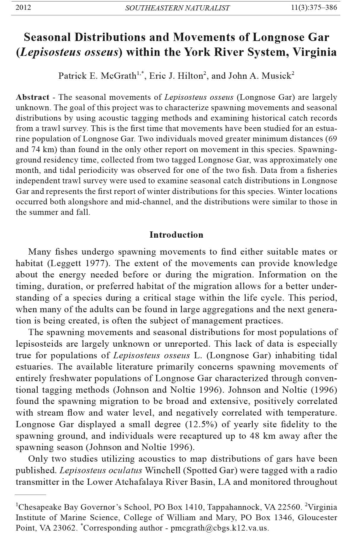
Field Site Description
The Mattaponi and Pamunkey rivers converge at West Point, VA to form the
York River (Fig. 1). These three rivers form the YRS, which is the fifth largest
tributary of Chesapeake Bay. The YRS comprises a main channel that varies
between 6 and 14 m wide and up to 20 m deep, and broad, shallow shoals less
than 2 m in depth (Nichols et al. 1991, Reay and Morre 2009). The channel bed is
dominated by a mud bottom, with occasional sand and shell, whereas the shoals
are typically sandier (Friedrichs 2009). The mouth of the YRS is polyhaline with
average tides of 0.7 m, whereas the upper reaches of the Mattaponi and Pamunkey
are freshwater with a tidal range of 1 m (Reay and Moore 2009, Sisson et al.
1997). Water temperatures vary considerably with season, ranging from 0 to 31
°C (Murdy et al. 1997). Nine tidal wetland community types are found within the
YRS, ranging from Saltmarsh Cordgrass to Tidal Freshwater Mixed (Perry and
Atkinson 2009). Submerged aquatic vegetation is dominated by Zostera marina
2012 P.E. McGrath, E.J. Hilton, and J.A. Musick 377
L. (Eelgrass) and Ruppia maritime L. (Widgeon Grass) at the mouth of the YRS
and Hydrilla verticulatta (L.f.) Royle (Hydrilla) in the tidal freshwater regions
(Orth et al. 2005, Moore 2009, Shields 2008).
Sandy Point is located 75 Km from the mouth of the York River (RKM 75)
in the tidal freshwater region of the Mattaponi River and is characterized by an
approximately 10-m-wide sand/mud shelf dominated by Hydrilla. Freshwater
Figure 1. Locations of the five successfully tracked Longnose Gar (LNG), tagging areas,
and listening station.
378 Southeastern Naturalist Vol. 11, No. 3
marshes, with a mix of Nuphar luteum (L.) J.E. Smith (Yellow Pond Lily),
Peltandra virginica (L.) Schott (Arrow Arum), and Pontederia cordata L. (Pickerel
Weed), occur on both the upriver and downriver sides of Sandy Point (P.E.
McGrath, pers. observ.). The tagging location on the Pamunkey River was on a
7-m-wide creek that drains into the Pamunkey River near the Cumberland Nature
Preserve. The vegetation was very similar to Sandy Point, with the tagging location
dominated by Hydrilla and a mix of Yellow Pond Lilies, Arrow Arum, and
Pickerel Weed occurring both upstream and downstream.
Methods
Historical data collected by the Virginia Institute of Marine Science (VIMS)
Juvenile Fish and Blue Crab Trawl Survey from 1979 to 2008 were examined
for temporal trends in abundance and location of Longnose Gar within the Pamunkey
and York Rivers. Unfortunately, this survey does not include stations
on the Mattaponi River. The trawl survey collects fishes from fixed and random
stations monthly using a 30-foot otter trawl with a tickler chain (Tuckey and
Fabrizio 2010). Trawling is not an ideal method for collecting Longnose Gar,
and the catch data were not indicative of their overall abundance. It would be
improper to utilize statistical tests and associate significance values with this
data. However, a catch per unit effort (CPUE; calculated as number of Longnose
Gar caught per tow) was calculated for each index station and for each
season. Seasonal CPUE’s were calculated by averaging the CPUE data from
each index station. This data was used as a non-statistical comparison of seasonal
relative abundances and distributions between each fixed station. A CPUE
could not be calculated for the general collection locations because these sites
were selected at random each month in only the York River. However, this data
was still utilized as a gross examination of the seasonal location of Longnose
Gar. Relative abundance at the fixed stations and general collection locations
of Longnose Gar were compared among Winter (December, January, and February),
Spring (March, April, and May), Summer (June, July, and August), and
Fall (September, October, and November).
Longnose Gar (n = 17) were tagged with thirteen radio (MCFT-3FM and
SR-TPH-25) and four dual radio/ultrasonic (CS-11-25) transmitters (Lotek
Wireless Inc., Newmarket, ON, Canada) to further evaluate seasonal and
spawning movements and habitat preferences (Table 1). The radio transmitters
are limited to freshwater, while the dual radio/ultrasonic transmitters can be
heard in both freshwater and marine habitats. All individuals were tagged during
the spawning season and on the spawning grounds. In the Pamunkey River,
Longnose Gar were tagged in a creek off the Cumberland Thoroughfare near
the Cumberland Nature Preserve. In the Mattaponi River, Longnose Gar were
tagged at Sandy Point (Fig. 1). A greater number of Longnose Gar was tagged
in the Mattaponi River due to a 24-hour tracking system stationed at Sandy
Point. Longnose Gar were caught by tended gillnets and tail-roped at the
river’s edge or alongside the boat until surgery could be performed. Healthy
2012 P.E. McGrath, E.J. Hilton, and J.A. Musick 379
Longnose Gar were then measured and fitted with acoustic tags. Tagging methods
were similar to those of Sneddon et al. (1999). In brief, tagging consisted
of drilling two small holes through the scale jacket at the base of the dorsal fin,
threading a thin metal wire attached to the tag through holes in the fish and the
tag, and then knotting the wire to ensure the tag remained in place. The wound
was then rinsed with iodine, and the Longnose Gar were held for at least 15
minutes to allow for recovery. Once fish were swimming normally, they were
released and tracked periodically over the life of the tag.
A Lotek yagi antenna (used when salinity was less than 1 ppt), hydrophone
(used when salinity was greater than 1 ppt), and receiver were used during the
active tracking portion of this project. Active tracking consisted of searching for
tagged fish during various fishery surveys. In 2007, active tracking occurred during
a bimonthly gillnet survey and consisted of kayaking a half mile upstream
and downstream from the original tagging locations. In 2008, active tracking
occurred aboard a small vessel while completing a monthly gillnet survey. The
survey was completed over the course of four days (8 hours/day) and consisted
of travel from RKM 40 on the York River to RKM 107 on both the Mattaponi
and Pamunkey Rivers. Active tracking also occurred opportunistically in the Pamunkey
and Mattaponi Rivers while accompanying the VIMS Juvenile Striped
Bass Seine Survey (12 trips/year; July–September, 2007 and 2008; RKM 33 to
55) and VIMS American Shad Pushnet Survey (24 trips, February–May, 2007;
RKM 79 to 131). When a Longnose Gar was located, the following data were
recorded: Longnose Gar number, position (eTrex GPS unit, Garmin, Olathe, KS),
air temperature, water temperature, and salinity.
Table 1. Date, tag model, tagging location, size, time between initial tagging and last position
recorded (duration), number of relocations (rel.), minimum distance traveled, and status of acoustically
tagged Longnose Gar.
Minimum
Tag model Size Duration distance
Fish # Date (life span in days) River (mm TL) (days) Rel. (km) Status
11 6/6/2007 MCFT-3FM (472) Mattaponi 1110 383 14 69.0 Alive
12 6/7/2007 MCFT-3FM (472) Pamunkey 880 356 9 3.7 Dead
13 5/25/2007 MCFT-3FM (472) Pamunkey 1002 1 1 0 Missing
14 5/16/2007 MCFT-3FM (472) Mattaponi 1018 396 11 74.0 Alive
15 5/25/2007 MCFT-3FM (472) Pamunkey 860 345 5 3.5 Dead
16 6/6/2007 MCFT-3FM (472) Mattaponi 900 1 2 0 Missing
17 5/16/2007 MCFT-3FM (472) Mattaponi 857 335 3 1.2 Dead
18 5/10/2008 MCFT-3FM (472) Mattaponi 801 74 7 7.0 Dead
19 5/10/2008 MCFT-3FM (472) Mattaponi 736 12 2 2.0 Missing
20 5/16/2008 SR-TP11-25 (497) Mattaponi 885 1 1 0 Missing
21 5/16/2008 SR-TP11-25 (497) Mattaponi 885 29 19 0.2 Alive
22 5/16/2008 SR-TP11-25 (497) Mattaponi 836 35 167 4.8 Alive
23 5/22/2008 SR-TP11-25 (497) Mattaponi 885 1 2 0.2 Missing
46 6/5/2008 CS-11-25 (418) Mattaponi 998 1 1 0 missing
47 5/22/2008 CS-11-25 (418) Mattaponi 971 26 2 0.6 missing
48 5/22/2008 CS-11-25 (418) Mattaponi 1085 1 1 0 missing
49 6/3/2008 CS-11-25 (418) Mattaponi 900 70 7 9.0 Alive
380 Southeastern Naturalist Vol. 11, No. 3
A fixed listening station was placed at Sandy Point on the Mattaponi River
from March 2008 to July 2009 (Fig. 1). This listening station was set up to
detect fish at the spawning grounds 24 hours a day and recorded when tagged
Longnose Gar arrived, the duration of their stay, and time of their departure from
the spawning ground. The complete area of detection on the spawning grounds
was unknown, although it covered at least from the shoreline to the edge of the
channel (approximately 10 m). The listening station was programmed to search
for a signal every minute, although for the purposes of analyses we examined
detections every fifteen minutes. This reduced the number of detections and made
it easier to identify tidal movements and duration of stays within the detection
zone. Tidal stages were broken into three parts: high tide, low tide, and intermediate
tide. High tide was 90 minutes before and after slack high water, low tide was
90 minutes before and after slack low water, and intermediate tide was the time
between high and low tide.
Fish were categorized as dead, missing, or alive. Dead fish were either inactive
for more than six months or were individuals with signals that were coming
from land. Missing fish were individuals located on fewer than three days. Alive
fish were located and displayed movement on three or more days. Dead and missing
fish were removed from the analyses. ArcGIS (ESRI, Redlands, CA) was used
to measure minimum distance moved for each fish.
Results
Five fish were presumed to be alive and were located on three or more days. The
other tagged fish were either declared missing (n = 8) or dead (n = 4). Acoustically
tagged Longnose Gar were relocated between March and August in areas with water
temperatures ranging from 11–31 °C and salinity values between 0 and 1 ppt.
Movements of Longnose Gar were not correlated to temperature except for the two
fish located by the passive listening array. The average time between initial release
and last detection was 182.6 days, and the range in days between initial release and
last detection was 35–396 days. The average minimum distance traveled was 31.4
km. Two individuals traveled much further, moving between the Mattaponi and Pamunkey
rivers.
Longnose Gar #11 (LNG11) was tagged in June 2007 at Sandy Point on
the Mattaponi River, and was relocated in the Pamunkey River in March 2008
(Fig. 1). The minimum in-stream linear distance traveled from the initial tagging
location was 69 km. This fish remained in the same general location in the Pamunkey
River for the next few months until the tag presumably failed at the end
of June. LNG14 had similar movement patterns as LNG11. It was also tagged at
Sandy Point in May 2007 and not relocated again until August 2007 in the Pamunkey
River (Fig. 1). The minimum in-stream linear distance traveled from the
initial tagging location was 74 km. This individual was then relocated in the same
general area of the Pamunkey (RKM 73–75) several times until the tag presumably
failed in June 2008.
2012 P.E. McGrath, E.J. Hilton, and J.A. Musick 381
LNG49 was relocated seven times over the course of 70 days (Fig. 1). This
fish first was located upstream after one week of being at liberty and then moved
downstream of the initial tagging location (9 km) and remained in this general
location until it was no longer detected in August of 2008. This could have been a
result of tag malfunction or movement into brackish water where signals became
more difficult to locate.
Two individuals (LNG21 and LNG22) were the only tagged fish to be located
by the fixed listening station. LNG21 was never located with active tracking
equipment. This fish was first relocated by the listening station 20 days after
being tagged, when it remained within the area of detection during low tide for
one hour before moving away once the tide began to flood. LNG21 returned
into the area of detection 10 days later and remained there for the three hours
surrounding low tide. On two separate days, this fish was located in the area of
detection 17 times during low tide, once between tides, and never at high tide.
LNG22 was located 4.8 km upstream six days after tagging. This was the only
instance when this fish was found during active tracking. LNG22 was located
by the listening station nine days after tagging. This fish continuously swam
in and out of detection range for 12 days, with the longest continuous detection
lasting 25 hours. LNG22 was relocated by the passive listening station
twice more during the next two weeks, both times lasting less than 15 minutes.
The last detection occurred 35 days after the initial tagging event. LNG22 was
located by the passive listening station 52, 46, and 67 times during high tide,
low tide, and intermediate tide, respectively. Both fish left the area of detection
when water temperature reached 29 ○C.
Longnose Gar (n = 225) were caught by the trawl survey from RKM 38 to
64 (Fig. 2). Water temperatures ranged from 4–31 °C and salinity values ranged
from 0–18 ppt. Longnose Gar were primarily caught in the Pamunkey River, but
catches also occurred in the York River during each season except for the spring.
More than half of the individuals (n = 149) were caught from the fixed (index)
stations (referred to as index fish). All index fish were caught at the upper three
index stations (stations 130, 135, and 140) located in the Pamunkey River. For
this reason, the seasonal CPUE was calculated as the average CPUE from stations
130, 135, and 140.
Winter catches were the lowest of all seasons, with an average CPUE = 0.004
and only occasional catches occurring throughout the Pamunkey and upper York
rivers (Figs. 2a, 3). During the spring, all individuals were caught in the Pamunkey
River, and most of the index fish (average CPUE = 0.03) were caught at
furthest upriver station (140; RKM 64; Figs. 2b, 3). Longnose Gar were caught
more often in the summer (average CPUE = 0.06) and fall (average CPUE =
0.07). Summer and fall distributions were spread throughout the Pamunkey and
upper York rivers (Fig. 2c, d). The index fish in the summer were more frequently
caught at station 130 (RKM 48) and then decreased with each upriver index
station, while index fish in the fall were evenly spread between the upper three
stations (Figs. 2c, 2d, and 3).
382 Southeastern Naturalist Vol. 11, No. 3
Discussion
Seasonal movements and distributions
A portion of the population of Longnose Gar in the York River System appears
to undergo extensive movements during the spring spawning season. Evidence to
support this was provided by the long distance movements of the two tagged fish,
the trawl survey’s seasonal catch distribution, and the lack of tagged fish remaining
near the spawning site. Two individuals moved from the freshwater region of
the Mattaponi River through brackish water and into the freshwater region of the
Pamunkey River. The minimum distance travelled by both fish (69 and 74 km)
was greater than the only other report on long-distance movements of Longnose
Figure 2. Location of VIMS juvenile finfish and blue crab trawl survey index stations
and seasonal catch distributions and total number of Longnose Gar from 1989–2008:
A) winter, B) spring, C) summer, and D) fall.
2012 P.E. McGrath, E.J. Hilton, and J.A. Musick 383
Gar (48 km; Johnson and Noltie 1996). The longer distance traveled by fish in this
study might be due to physical differences between the two study sites. Johnson
and Noltie (1996) tagged fish in a small creek tributary of the Harry S. Truman
Reservoir, while our study was done in a large riverine system. The long-distance
movements were also greater than the furthest known movements of acoustically
tagged Alligator Gar (Sakaris et al. 2003). Typically, larger fishes require greater
space and move farther than smaller fishes (Jones 2005, Minns 1995). However,
only one third (n = 5) of the tagged Alligator Gar in that study were relocated more
than five times. Further research is needed to properly investigate if individual
Longnose Gar have a greater range than Alligator Gar.
The VIMS Juvenile Finfish and Blue Crab Trawl Survey does not encompass
the entire range of Longnose Gar in Virginia, but it does encompass a wide range
of habitats based upon levels of salinity. Longnose Gar were never caught in water
with a salinity value higher than 18 ppt even though they are commonly found
in the Cape Fear River estuary at higher salinities (Schwartz 2003). An upriver
spring spawning migration was evident in the trawl-survey catch distribution; after
the spawning season, Longnose Gar appear to disperse downstream. Catches
were most evenly distributed among all sites during the fall and winter.
The ability of Longnose Gar to withstand a range of salinity values (0–31 ppt;
Jean 1946, Schwartz 2003) and its dependence on freshwater to spawn, forces a
portion of the population to travel great distances each spring. Future work should
explore whether Longnose Gar fit within Clark’s contingency theory, which states
that members of a migratory population have contingents that maintain their integrity
by each “engaging in a distinct pattern of seasonal migrations not shared
Figure 3. Seasonal catch per unit effort (CPUE) at three index stations in the Pamunkey
River.
384 Southeastern Naturalist Vol. 11, No. 3
by fish of other contingents” (Clark 1968:337). Studies in similar tidal riverine
systems as the YRS have demonstrated contingents for Morone saxatilis Walbaum
(Striped Bass; Secor 1999) and M. americana Gmelin (White Perch; Kraus
and Secor 2004). White Perch occur in similar habitat and undergo similar spring
spawning migrations as Longnose Gar (Kraus and Secor 2004), but it remains to be
determined if they also have similar brackish and freshwater contingents.
Spawning-site movements
Two acoustically tagged Longnose Gar remained around the spawning grounds
and were relocated by the listening station, providing some insight into possible
spawning behavior. LNG21 and LNG22 were tagged during the spawning season
and located by the listening station periodically for one month. The cessation of
spawning, based on not having recorded them again at the listening station, appears
to have occurred during the same week in late June for both individuals.
This time frame for the end of spawning was also confirmed with a lack of egg
collections and a decrease in GSI values (P.E. McGrath, unpubl. data). The duration
for these individuals on the spawning grounds is consistent with previously
reported spawning residency times of Longnose Gar (Johnson and Noltie 1996).
Residency times on the spawning grounds in this previous study ranged from
15 to 94 days, with males staying on the spawning grounds longer than females
(Johnson and Noltie 1996). Unfortunately, complete residency times from the
current study are underestimates because it is unknown when each fish arrived at
the spawning grounds.
Although the total duration was similar, the behavior on the spawning grounds
was markedly different between the two tagged Longnose Gar. LNG21 was only
located within the area of detection during low tide. Spawning at low tide may
enable Longnose Gar to locate areas of vegetation that remain submerged at the
lowest water levels, preventing the eggs from desiccating. Conversely, LNG22
did not display tidal periodicity, but rather swam evenly within the area of detection
at all stages of the tide cycle. This fish was also located more often and
remained within the area of detection for longer periods of time, although it is
impossible to determine if courtship or spawning was occurring during this entire
time or only around low tide.
The next step before proceeding with future lepisosteid tagging studies should
be a controlled tank study to examine the effects of the surgical procedures and
tag placement on Longnose Gar. Previous acoustic tagging studies on Spotted
Gars (Snedden et al. 1999) and Alligator Gars (Sakaris et al. 2003) also did not
complete a controlled tank study, and it is unknown if these stressors affect the
behavior or mortality of the individual. Future studies may also want to experiment
with the type of acoustic tag. The Mattaponi and Pamunkey rivers are
muddy and brackish below RKM 75, which may have had a negative impact on
our radio tags that were designed for low-conductivity rivers (Winter 1996). An
attempt was made to locate Longnose Gar in brackish water with the dual radio/
ultrasonic transmitters, but only one of the four fish was relocated (LNG49), and
this fish was never relocated in brackish water.
2012 P.E. McGrath, E.J. Hilton, and J.A. Musick 385
Conclusion
This study represents the first attempt to acoustically tag Longnose Gar for
the purpose of describing seasonal and short-term movements, and is the first to
examine the movements and distribution of Longnose Gar inhabiting an estuarine
river system. Long-distance movements and spawning site residency and
behavior were recorded for a few individuals, but additional tagging studies
are needed to confirm these results. This project provides the first description
of spawning residence times for Longnose Gar in tidal rivers; however, many
questions remain regarding their behavior at spawning locations in tidal systems
versus those in non-tidal freshwater lakes and rivers. Additional studies
are needed to determine spawning-site residency times, spawning-site fidelity
during one year and between years, and possible intermittent use of spawning
sites coinciding with tidal periodicity. Identification of the sex of the tagged
individuals (e.g., see McGrath and Hilton 2012) will also enable future tagging
studies to better examine the spawning behaviors of males and females. The
present study is also the first description of Longnose Gar winter distributions,
which were similar to areas utilized during fall and summer. Further research is
warranted on the behavior and distribution of Longnose Gar to have a better understanding
of the ecology of these apex predators.
Acknowledgments
We thank the VIMS Juvenile Striped Bass Seine Survey and VIMS Pushnet Survey
for assisting with specimen collection for this study, as well as numerous volunteers for
their field assistance. We thank J. Brubaker, R. Latour, T. Munroe, and 2 anonymous
reviewers for comments on a draft of this manuscript. This project was conducted under
IACUC #20051006. Funding was provided by NSF grant DGE-084084 and the Department
of Fisheries Science (VIMS). This is contribution number 3220 of the Virginia
Institute of Marine Science, College of William and Mary.
Literature Cited
Clark, J. 1968. Seasonal movements of Striped Bass contingents of Long Island
Sound and the New York Bight. Transactions of the American Fisheries Society
97:320–343.
Friedrichs, C.T. 2009. York River Physical Oceanography and Sediment Transport. Journal
of Coastal Research 57:17–22.
Jean, Y. 1946. Two Northern Longnose Gar, Lepisosteus osseus oxyurus Rafinesque,
caught in the estuary of the St. Lawrence, Quebec. Copeia 2:100.
Johnson, B.L., and D.B. Noltie. 1996. Migratory dynamics of stream-spawning Longnose
Gar (Lepisosteus osseus). Ecology of Freshwater Fish 5:97–107.
Jones, K.M. 2005. Home range areas and activity centres in six species of Caribbean
wrasses (Labridae). Journal of Fish Biology 66:150–166.
Kraus, R.T., and D.H. Secor. 2004. Dynamics of White Perch (Morone americana) population
contingents in the Patuxant River estuary, Maryland, USA. Marine Ecology
Progress Series 279:247–259.
Leggett, W.C. 1977. The ecology of fish migrations. Annual Review of Ecology and
Systematics 8:285–308.
386 Southeastern Naturalist Vol. 11, No. 3
McGrath, P.E., and E.J. Hilton. 2012. Sexual dimorphism in Longnose Gar (Lepisosteus
osseus) from tidal rivers of Virginia. Journal of Fish Biology 80:335–345.
Minns, C.K. 1995. Allometry of home-range size in lake and river fishes. Canadian Journal
of Fisheries and Aquatic Sciences 52:1499–1508.
Moore, K.A. 2009. Submerged aquatic vegetation of the York River. Journal of Coastal
Research 57:50–58.
Murdy, E.O., R.S. Birdsong, and J.A. Musick. 1997. Fishes of Chesapeake Bay. Smithsonian
Institution Press, Washington, DC. 324 pp.
Nichols, M., S. Kim, and C. Brouwer. 1991. Sediment characterization of the Chesapeake
Bay and its tributaries, Virginian Province. National Estuarine Inventory Supplement.
NOAA Strategic Assessment Branch. Silver Spring, MD. 88 pp.
Orth, R., D. Wilcox, L. Nagey, A. Owens, J. Whiting, and A. Kenne. 2005. 2004 distribution
of submerged aquatic vegetation in Chesapeake Bay and coastal bays. Virginia
Institute of Marine Science Special Scientific Report #146. Gloucester Point, VA.
Perry, J.E., and R.B. Atkinson. 2009. York River Tidal Marshes. Journal of Coastal Research
57:40–49.
Reay, W.G., and K.A. Moore. 2009. Introduction to the Chesapeake Bay National Estuarine
Research Reserve in Virginia. Journal of Coastal Research 57:1–9.
Sakaris, P.C., A.M. Ferarra, K.J., Kleiner, and E.R. Irwin. 2003. Movements and home
ranges of Alligator Gar in the Mobile-Tensaw Delta, Alabama. Proceedings of the
Annual Conference of Southeastern Associations of Fish and Wildlife Agencies
57:102–111.
Secor, D.H. 1999. Specifying divergent migrations in the concept of stock: The contingent
hypothesis. Fisheries Research 43:13–34.
Schwartz, J. 2003. Longnose gar, Lepisosteus osseus (Family Lepisosteidae) in North
Carolina, especially the Cape Fear River. Journal of The North Carolina Academy of
Science 119:26–32.
Shields, E.C. 2008. Influences of habitat conditions on submerged aquatic vegetation
development in the Chickahominy River and other Virginia tributaries of the Chesapeake
Bay. M.Sc. Thesis. College of William and Mary, Williamsburg, VA. 141 pp.
Sisson, G., J. Shen, S. Kim, J. Boone, and A. Kuo. 1997. VIMS three-dimensional hydrodynamic-
eutrophication model (HEM-3D): Application of the hydrodynamic model
to the York River system. SRAMSOE Report No. 341. Virginia Institute of Marine
Science. Gloucester Point, VA. 123 pp.
Snedden, G.A., W.E. Kelso, and D.A. Rutherford. 1999. Diel and seasonal patterns of
Spotted Gar movement and habitat use in the Lower Atchafalaya River Basin, Louisiana.
Transactions of the American Fisheries Society 128:144–154.
Tuckey, T.D., and M.C. Fabrizio. 2010. Estimating relative juvenile abundance of ecologically
important finfish in the Virginia portion of Chesapeake Bay. Project # F-104-
R-14. Annual Report to the Virginia Marine Resources Commission. Virginia Institute
of Marine Science, Gloucester Point, VA. 84 pp.
Winter, J. 1996. Advances in underwater biotelemetry. Pp. 555–590, In B.R. Murphy
and D.W. Willis (Eds.). Fisheries Techniques, Second Edition. American Fisheries
Society, Bethesda, MD. 732 pp.


 The Southeastern Naturalist is a peer-reviewed journal that covers all aspects of natural history within the southeastern United States. We welcome research articles, summary review papers, and observational notes.