2013 SOUTHEASTERN NATURALIST 12(3):457–477
A Comparison of Fixed-Width Transects and Fixed-Radius
Point Counts for Breeding-Bird Surveys in a Mixed
Hardwood Forest
James F. Taulman*
Abstract - The fixed-width strip-transect and fixed-radius point-count survey methods
for breeding birds were evaluated side-by-side in 2009, 2010, and 2011 in a 200-ha mixed
hardwood forest surrounded by urban development in Parkville, MO. One 2-ha strip
transect (80 m x 250 m) and four 0.5-ha fixed-radius plots (40 m radius, 150 m separation)
were surveyed in adjacent riparian forest areas during May and June, 2009. In 2010,
two additional sets of transects and corresponding circular-plot arrays were installed,
bringing the total area surveyed by each method to 6 ha in 2010 and 2011. Abundance
of individuals of all species was greater on circular-plot arrays compared with transects
in both 2009 and 2010. Modeling the potential intersection of transect and circular-plot
arrays on a background simulating a landscape distribution of bird territories at varying
densities indicated that a dispersed array of circular survey plots may overlap more bird
territories than contiguous strip transects, though both survey plots enclose the same total
forest area. The fixed-radius point-count method appears to effectively sample a larger
forest patch than the fixed-width transect method, possibly resulting in estimations of
bird population parameters that are different between the two methods.
Introduction
A variety of survey methods have been developed and used by researchers
attempting to describe characteristics of bird populations. The fixed-width striptransect
method (Conner and Dickson 1980) consists of a rectangular area in a
habitat through which the observer walks along a center line, recording birds
seen or heard out to a specified distance on each side. A transect size of 80 m x
250 m is commonly used (Dickson et al. 1993, Thill and Koerth 2005, Watson
2004) because these dimensions provide a 2-ha area in each surveyed plot, and
the 40-m distance from the observer to the plot boundary on each side is a good
compromise between covering as much area as possible and still allowing detection
of species that are quiet or otherwise cryptic (Alldredge et al. 2007, Hutto et
al. 1986).
The fixed-radius circular point-count method (Hutto et al. 1986) is also
commonly applied to studies of bird populations (Buckland 2006, Carey 1988,
Gregory et al. 2004, Pagen et al. 2000, Petit et al. 1994, Rodewald and Smith
1998, Tarvin et al. 1998). Circular-plot centers are typically either spread around
a study area (Petit et al. 1994) or spaced along a linear transect through a habitat
to be surveyed (Carey 1988, Gregory et al. 2004, Hutto et al. 1986). Fixed-radius
circular plots are separated by rather large distances, 150 m (Manuwal and Carey
1991) to 200 m (Barber et al. 2001) or even 250 m and more (Ralph et al. 1993)
*Department of Natural and Physical Sciences, Park University, 8700 NW River Park
Drive, Parkville, MO 64152; james.taulman@park.edu.
J.F. Taulman
2013 Southeastern Naturalist Vol. 12, No. 3
458
between plot centers, in order to reduce the possibility of recounting individual
birds on adjacent plots.
Both of these survey methods allow the creation of comparative indices
describing 1) bird species richness (number of different species recorded per
visit), 2) frequency of species detection (percent of replicated surveys on which
a species was detected), 3) abundance (the mean numbers of individuals of a
given species detected over all replicated surveys), 4) relative abundance (total
numbers of individuals of a each species divided by the total numbers of all birds
detected), and 5) densities of each species (mean number of birds of each species
detected per survey divided by the plot area) (Conner and Dickson 1980, Hutto et
al. 1986, Manuwal and Carey 1991, Thill and Koerth 2005). Species diversity and
evenness indices can also be computed from these two survey methods (Conner
and Dickson 1980).
In comparing the benefits and limitations of each of these methods, Manuwal
and Carey (1991) found both the fixed-width transect and fixed-radius point-count
methods to be suitable for determining relative abundance, population trends, and
densities. They favored the fixed-width strip-transect method over fixed-radius
circular plots for estimation of species richness. Verner and Ritter (1985) found
the fixed-width transect and fixed-radius point-count methods equally applicable
to species richness estimates. They reported certain advantages in the fixedradius
point-count method over the strip-transect surveys, such as 1) allowing
better control of timing of the counting period, 2) allowing the observer to concentrate
fully on bird detection and identification during the survey, without the
distraction of having to walk through the plot, and 3) allowing a bird survey to
be conducted in a small habitat patch. The strip-transect method was deemed
more efficient at collecting total bird counts, however, because a given area can
be surveyed in one timed bout, whereas a certain amount of additional time is
necessary in traveling between an array of dispersed circular plots enclosing the
same survey area as the transect. Verner and Ritter (1985) and Buckland (2006)
concluded that transects provide superior results in estimating bird densities than
circular-plot counts.
Criteria used for selection of the survey method employed are often not stated
(such as Noss 1991), but choosing between these two common methods has
sometimes been based on shape of the habitat to be surveyed. A large, contiguous
study area may be effectively surveyed with an array of fixed-radius circular
plots spaced throughout it in order to provide full coverage (Petit et al. 1994).
But small or narrow habitats might be more easily and adequately surveyed with
a number of fixed-width strip transects (Noss 1991, Thill and Koerth 2005).
Gregory et al. (2004) suggested using strip transects for large, heterogeneous,
open habitats with conspicuous bird species, while advising that circular-plot
point counts are better suited for forest habitats and more cryptic species. Ralph
et al. (1993) stated that strip transects are very similar to point counts, but point
counts are the more efficient method in forests. Despite describing many contrasting
features favoring one method over another in different applications,
Gregory et al. (2004) consider strip (line) transects and circular-plot arrays to be
459
J.F. Taulman
2013 Southeastern Naturalist Vol. 12, No. 3
equivalent variations on the transect method. They even suggest that strip transects
and circular survey plots may be combined for a single survey. Fixed-width
strip-transect and fixed-radius point-count survey methods have been used interchangeably
in breeding-bird surveys without an evaluation of the comparability
of population indices produced by each method.
In order to directly examine the similarity of data produced by these two
survey methods, I conducted a side-by-side evaluation of the strip-transect and
fixed-radius circular-point survey techniques, employing both methods to survey
adjacent riparian forest patches in a small mixed hardwood forest. My working
hypothesis was that both methods would produce similar results with regard to
bird population parameters commonly computed through fixed-area surveys,
such as species richness and abundance.
The intent of this study was not to evaluate the effectiveness of either of
these survey methods in estimating true population parameters of bird species.
Regardless of their predictive accuracy, both survey methods are still used by
researchers to gain information about bird populations and to compare population
indices among different sites (Hostetler and Main 2011, Link and Sauer 1998,
Shriver et al. 2005), and the two methods are sometimes even considered equivalent
and combined in single surveys (Gregory et al. 2004). Therefore, it is useful
to compare both survey methods side by side in order to examine the similarity
of data obtained under each protocol.
Field-Site Description
The study area surveyed is a hardwood forest of about 200 ha adjacent to the
campus of Park University, in Parkville, MO (39.190°N, 94.667°W, WGS 84;
Fig. 1). About 150 ha of this forest is owned by Park University, and another
contiguous 50 ha is managed by the city of Parkville and the Missouri Department
of Conservation. The terrain in this small hardwood forest is rolling, with
riparian and upland portions and an elevation relief of about 75 m. Survey plots
were placed in undisturbed riparian forest along creek channels. The study area
is surrounded by a busy urban landscape with heavy freight-train traffic, a rock
quarry, a small commercial area, a university campus, urban neighborhoods, and
an airport nearby. The riparian forest overstory is dominated by Tilia americana
L. (Basswood), but Celtis occidentalis L. (Hackberry), Ulmus americana L.
(American Elm), Quercus muehlenbergii Engelm. (Chinquapin Oak), and Carya
cordiformis Wangenh. (Bitternut Hickory) are also common. Ostrya virginiana
Mill. (Eastern Hophornbeam) is a common midstory tree, and Asimina triloba L.
(Pawpaw) is abundant in the understory.
Materials and Methods
Habitat description
In order to compare results from breeding-bird surveys utilizing these two
methods, it was necessary to examine the variation in features of the riparian
forest habitat under consideration. Four 20-m x 20-m square macroplots
J.F. Taulman
2013 Southeastern Naturalist Vol. 12, No. 3
460
(0.04 ha) were installed along the single strip transect in a systematic random
method in 2009, and two more macroplots were placed in each of the additional
transects in 2010. One macroplot was randomly placed in each of the four circular
plots in 2009 and in four of the eight additional circular plots in 2010.
At each macroplot, the following forest characteristics were described: ground
cover, percent coverage of the plot by woody shrubs under 2 m high, understory
horizontal vegetation density from ground level up to 3 m height, stem counts
of trees 2.5–10 cm DBH, individual DBH measurements and identification of
all trees >10 cm diameter (for a calculation of basal area), canopy cover, prism
basal area (to compare with measured basal area), and height of the dominant tree
on the plot. Ground cover was estimated visually for grass, leaves, down wood,
rock, and bare ground/water, with a total coverage sum of 100%. Percent shrub
cover was also estimated visually.
Vegetative density was measured at four horizontal strata by estimating leafy
coverage on a 0.5-m-square checkered board held at 10 m from plot center. An
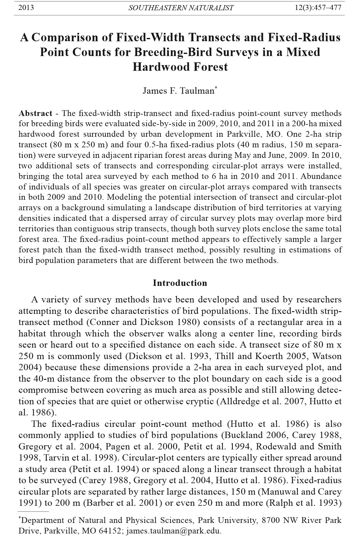
Figure 1. Bird survey areas, 2009–2011. The one shaded rectangle and 4 shaded circles
represent the 2-ha transect and four 0.5-ha circular plots surveyed in 2009, 2010, and
2011. For the 2010 and 2011 seasons, two additional transects and eight new circular
plots were surveyed in other similar riparian forest habitat, shown by the open figures.
Six ha of forest area was surveyed in each set of three transect plots and 12 fixed-radius
circular plots in 2010 and 2011. Positioning and dispersal of plots as shown was necessary
to allow placement in suitable undisturbed riparian forest habitat within this small
urban hardwood forest.
461
J.F. Taulman
2013 Southeastern Naturalist Vol. 12, No. 3
observer recorded the percentage of the board covered by vegetation while looking
across horizontally at the board held with the center at heights of 0.25, 1,
2, and 3 m. The board was held at the four cardinal directions from plot center,
and the four readings at each stratum were averaged. This is a modification of a
method described by MacArthur and MacArthur (1961), and subsequently used
by others (Thill and Koerth 2005), in which the board is moved away from the
observer until it is 50% obscured by vegetation. The modified method used here,
recording a variable percent coverage of the board at a standard distance, is
much faster than the earlier method, and avoids the potential problem in a habitat
with little vegetation of having to move the board to a great distance in order to
achieve the needed 50% coverage (up to 50 m required in seedling stands studied
by Thill and Koerth [2005]). This modified method also provides an easily interpreted
description of vegetative density at the four understory strata that I have
used effectively in previous research (Taulman 1999, Taulman and Smith 2004,
Taulman et al. 1998). Canopy cover was measured using a spherical densiometer,
a convex mirror with 24 grid squares held at waist level on which leafy canopy
vegetation coverage was estimated. The mirror was read at the four cardinal directions
from plot center, and the total squares covered were multiplied by 1.04
to provide a canopy-cover percentage estimate (24 x 4 x 1.04 ≈ 100). A 10-factor
prism was used to estimate basal area from plot center. Height of the dominant
tree was measured with a clinometer.
Bird survey areas and procedures
I was the only observer on all surveys in this study over all three years. In
2009, an 80-m x 250-m strip transect (2 ha) was defined along the creek in a
ravine in the core of the Park University forest study area >100 m from any
habitat edge (Fig. 1). Strip transects with these dimensions have been recommended
and used by others for bird surveys in similar forest settings (Conner
and Dickson 1980, Dickson et al. 1993, Thill and Koerth 2005). I walked down
the center line of the strip transect, spending 32 min in passage, recording all
birds seen and heard out to the transect boundary. Locations of birds were
noted on the data sheet, and care was taken to ensure that birds seen or heard
were not tallied twice. Some researchers have suggested an appropriate rate of
about 1.0 km/hr for transit through a strip transect of similar size during a bird
survey, or about 15 min for a transect of 250 m (Conner and Dickson 1980,
Manuwal and Carey 1991). However, others have found it valuable to spend
longer, from 20 min (Watson 2004) to about 30 min (Thill and Koerth 2005), to
complete a strip transect survey of that size. The 32-min duration in this study
also allowed equalization of observer effort for surveys of both the 2-ha strip
transect and the 2 ha in the four fixed-radius point-count plots, which were
surveyed for 8 min each.
In 2009, four fixed-radius circular plots (40 m radius) were established along
a creek in a ravine adjacent to the one containing the strip transect, with a ridge
of about 30 m height separating the two ravines. All birds seen and heard within
J.F. Taulman
2013 Southeastern Naturalist Vol. 12, No. 3
462
40 m of the center line of the strip transect, and within the 40-m-radius circular
plot, were recorded (Conner and Dickson 1980, Gregory et al. 20 04).
Distance to the 40-m plot or transect boundary was measured with a laser
rangefinder (Bushnell Yardage Pro, Bushnell Corp., Overland Park, KS). Species
known to be migrants or local residents but non-breeders in the forest,
such as Vermivora peregrine W. (Tennessee warbler) and Branta canadensis L.
(Canada Goose), respectively, were not recorded (Petit et al. 1994). Adjacent
circular-plot centers were separated by at least 150 m and sampled for 8 min
each from the plot center , as recommended by Manuwal and Carey (1991) and
Tarvin et al. (1998).
The 40-m maximum detection distance has also been used in similar forests
by Dickson et al. (1993), Dickson et al. (1995), Petit et al. (1994), Petit et al.
(1995), and Thill and Koerth (2005), and that detection distance is within the
recommended range of 35–50 m of Conner and Dickson (1980) but less than the
50-m radius used by Rodewald and Smith (1998) and recommended by Ralph et
al. (1993). However, Ralph et al. (1993) did suggest that the survey-plot radius
can be reduced in densely vegetated or noisy forests to as little as 25 m. In support
of a shorter detection distance, Alldredge et al. (2007) found that errors in
estimating the distance of birds using auditory detection were highly variable,
depending on the species and orientation of the bird with respect to the observer.
They concluded that even trained observers were unable to accurately estimate
distance of birds in the range of 65 to 86 m.
Vegetation density in the forest often precluded visually observing birds at
the boundary of the survey area, forcing reliance on hearing songs and calls. Alldredge
et al. (2007) investigated the factors producing errors in judging distance
to singing birds, such as orientation of the bird in relation to the observer and
volume of the song in different species. In order to reduce the bias associated
with misjudging distance in birds near the boundary of the transect or circular
plot, I omitted every other song or sighting very near the boundary, assuming that
as many of the distant birds were just outside the survey area as were just within
it. I personally conducted all surveys in order to avoid problems with consistency
of data among different observers (Buckland 2006; Conner and Dickson 1980;
Johnson 1995, 2008; Manuwal and Carey 1991). More importantly, any observer
bias, such as differences in detectability of species, was similar between the two
survey methods under consideration. Because comparison of data produced by
each method was the aim of the study, any bias inadvertently entering into data
collection was applied consistently across methods and should not reduce the
validity of comparisons of indices between methods.
Conner and Dickson (1980) and Manuwal and Carey (1991) advised surveying
at least 8 ha of forest in order to encompass enough habitat for a valid bird
survey. For the 2010 and 2011 seasons, the survey area was enlarged as much
as possible to cover the riparian habitat in this forest while maintaining required
separation between circular plots in point-count arrays. This enlargement consisted
of adding two new 2-ha transects and eight new 0.5-ha fixed-radius circular
463
J.F. Taulman
2013 Southeastern Naturalist Vol. 12, No. 3
survey areas, separated again by at least 150 m (Fig. 1). The 2009 areas were also
included in the 2010 survey, producing a total of 6 ha surveyed in 3 strip transects
and 6 ha in twelve 0.5-ha circular plots. The isolated urban forest in this study
did not have sufficient riparian forest habitat to permit a larger survey area for
additional sets of both transects and circular -plot arrays.
I conducted bird surveys in 2009 from 17 May through 24 June between the
times of 0630 and 1000, in 2010 from 18 May through 15 June between 0630
and 1100, and in 2011 from 1 June through 30 June between 0630 and 1030
(Conner and Dickson 1980, Dickson et al. 1993, Hutto et al. 1986, Rodewald
and Smith 1998). Field activity was begun later in 2011 in order to better coincide
with arrival of resident breeding birds and to avoid non-breeding migrants
that had been detected during the early days of the 2009 and 2010 surveys. In
2009, I surveyed both the strip transect and the four fixed-radius plots once per
day on 14 different visits, in order to compensate somewhat for the small forest
area surveyed (Carey 1988) and to reduce within-treatment variation (Conner
and Dickson 1980). I completed 10 replications in 2010 and 8 in 2011 for both
the three transects as well as the twelve 0.5-ha circular study areas. Though
time constraints did not allow the same number of repeated visits during all
years, the same number of surveys was conducted and equal effort expended for
each survey method within a given season. I visited both the transect and circular-
plot array on each survey in 2009, and I visited two sets of s tudy areas each
day during 2010 and 2011: two transects and eight associated circular plots.
The sequence of surveys at the transects and circular-plot arrays was alternated,
starting on the strip transect one morning and then beginning o n the fixed-radius
plots the next time out. No surveys were conducted during rain or high-wind
conditions (Manuwal and Carey 1991).
Hutto et al. (1986) recommend multiple counts at a given study area (25
used in their landscape study), but with no replications at any particular survey
point, and Gregory et al. (2004) suggested visiting plots no more than four
times. However, many researchers have recommended and used 8–12 replications
of surveys on each plot (Carey 1988; Conner and Dickson 1980; Dickson
et al. 1993, 1995; Noss 1991; Tarvin et al. 1998; Thill and Koerth 2005). Ralph
et al. (1993) suggested a single visit to each plot during a season for point
counts, but advised 8–12 visits to survey areas in spot-mapping surveys where
information on densities and distribution of territories in small patchy habitats
is sought. The goal in the present study was to evaluate as fully as possible the
different population indices that might be obtained by the strip-transect and circular-
plot survey methods, primarily species richness and abundance. Multiple
visits to each site allowed the possibility of encountering individuals in territories
only partially overlapped by the survey plots to produce more accurate
index of overall species abundance, after averaging counts per visit.
Statistical analyses
Density-board data and overstory-tree basal areas were compared separately
among the macroplots within the transects and within the fixed-radius
J.F. Taulman
2013 Southeastern Naturalist Vol. 12, No. 3
464
point-count areas in order to examine continuity of understory vegetative density
and basal areas within each sampling area. Vegetative density and tree basal areas
were compared between strip transect and fixed-radius macroplots. The Kruskal-
Wallis ANOVA was used for comparisons within and between survey areas. The
Mann-Whitney U test was used to compare all other habitat variables between
the groups of strip-transect and fixed-radius macroplots.
Because the area in an array of four fixed-radius point-count plots was the
same as the area contained in a single fixed-width strip transect, bird data from
the four fixed-radius circular plots in 2009 were combined to compare with the
transect data. In 2010 and 2011, data from all 12 circular plots were combined
each year for comparisons with the 3 strip transects. In bird surveys, a comparative
index of species richness was described as the number of species detected
in each survey area on a given day. Average bird abundance was analyzed using
the Mann-Whitney U test. Bird abundance was considered to be the number of
individuals of each species detected in each of the areas on a given visit, with
the average calculated over all surveys providing an estimator of the population
of a given species in that defined survey area. Where a survey plot overlapped a
small portion of a bird’s territory, multiple visits increased the likelihood of encountering
one or both members of that breeding pair in the part of their territory
intersected by the survey plot. Frequency of detection of each species was also
computed for each of the survey areas over the course of the 14 visits in 2009, 10
surveys in 2010, and 8 visits in 2011. Species richness and abundance estimates
were compared with the Mann-Whitney U test. Frequency of detection, and numbers
of birds in, each species detected on both the transect and circular-plot arrays
(23 species in 2009, 29 in 2010, and 23 in 2011), were compared in a pairwise
manner with the Wilcoxon Matched Pairs test.
Shannon’s diversity indices (H') for both survey areas were compared using
the Mann-Whitney U test. The Margalef’s index of community diversity and
species evenness indices were also computed for the species detected on both the
transect and circular-plot array survey areas (Carey et al. 1991, Magurran 2003,
Stainfield 2009). An α = 0.05 significance level was used for all tests.
Simulation exercise
Because fixed-radius circular-plot centers were at least 150 m apart, the distance
from the center point of the first to the fourth circular plot was at least 450 m.
Though the actual area surveyed was the same in both the transects and circularplot
arrays, the additional forest area within which an array of 4 circular plots was
dispersed may have overlapped the territories of more birds of a given species than
were sampled within the contiguous 2 ha of a strip-transect survey area.
In order to examine the possible differences in the number of breeding-bird
territories that could be intersected by 2-ha transects and arrays consisting of
4 circular plots of 0.5 ha separated by 150 m, I created a model of a landscape
with a background simulating territories of pairs of breeding birds of a given
species, and tested the ways in which transects and circular plot arrays could
465
J.F. Taulman
2013 Southeastern Naturalist Vol. 12, No. 3
overlap those territories. The area of a typical territory of a breeding bird
pair was defined in the model as 5.86 ha, and represented by a circle 273 m in
diameter (Fig. 2). The territory size used in this model is the mean for 16 breeding
bird species found in this forest whose territory sizes were also reported
by Hamel (1992) for similar forests in the southeastern US. Because pairs of
breeding birds attempt to exclude others from their territories, territories in the
model do not overlap one another.
The first iteration of this model portrayed a landscape saturated with territories
of a bird species, with each territory abutting another on 4 sides, assuming
maximum utilization of the habitat. Onto this background, I overlaid a 20-m
x 20-m grid, numbered each grid location, and then randomly placed scaled
80-m x 250-m (2 ha) strip transects into the gridded territory array. I also
randomly assigned an azimuth to each transect (1°–360°) in each trial placement.
The number of territories overlapped by each transect was recorded in
100 trial placements. I next placed into the bird-territory array four different
configurations of four circular plots scaled to 0.5 ha each (40 m radius, 2 ha
total) and separated by 150 m (Fig. 2). The four configurations of circular-plot
arrays were tested in order to examine whether any one of a number of possible
Figure 2. Model simulating the possible overlap of 2-ha strip transects and arrays of
four 0.5-ha circular plots, in four typical configurations, on a background of breeding
bird territories. Territory size for a pair of breeding birds in this model is scaled at 5.86
ha (273 m diameter), an average of the territory sizes for 16 species of breeding birds
in southeastern forests of the United States, reported by Hamel (1992), which were also
detected in surveys in this study. Different hatch patterns in circular plots correspond to
the four different array configurations tested.
J.F. Taulman
2013 Southeastern Naturalist Vol. 12, No. 3
466
circular-plot array distributions overlap more bird territories than any other
(see Loehle et al. [2005] and Mitchell et al. [2006] for examples of circular-plot
distribution along grid locations). I repeated insertions of each of the four circular-
plot configurations 30 times (120 total trials), again assigning a random
grid location and random azimuth each time.
Assumptions in this test were that the researcher is not aware when installing
a strip transect or circular-plot array how that survey area will intersect existing
or future breeding bird territories, and that a random placement of scaled survey
areas onto a simulated background of bird territories in a model can serve
to investigate the phenomenon of actual territory overlap by survey areas in a
natural setting. I tested the number of territories overlapped by the 4 circular-plot
configurations with ANOVA to determine if one plot configuration overlapped
more bird territories than another. I then compared the number of bird territories
overlapped in the array by transects and circular plots using t he Student’s t-test.
I next randomly removed 50% of the bird territories from the original
background and repeated the random placement of 100 transects and 120
circular-plot arrays using the four different circular-plot arrays, simulating the
possible overlap of territories by the two survey methods in a patchy landscape
not fully saturated with territories. Finally, I repeated the simulation exercise by
removing 75% of the territories from the original background array to compare
the possible overlap of territories by the transects and circular-plot arrays in a
habitat where bird territories were at a 25% density .
Statistical analyses were performed using Statistica (Statsoft 2011).
Results
Habitat comparisons
Horizontal vegetative density was not different at any of the four measured
strata in comparisons between the 8 transect and 8 circular area macroplots
combined from 2009 and 2010, or in comparisons between the 4 transect and
4 circular area macroplots in 2009. In the 2010 macroplots, the 0.25-m stratum
density (% coverage of a board viewed at a distance of 10 m) was higher on
circular plots than transect plots (circular plots: x = 34.7%, SE = 6.2; transects:
x = 20.9, SE = 4.6; U = 74.5, P = 0.04). In comparisons of the 4 circular-area
macroplots in 2009 with the 4 added circular area plots in 2010, the vegetation
density at the 2-m stratum was greater on the 2010 macroplots (2009: x = 4.7%,
SE = 1.9; 2010: x = 20.8%, SE = 6.4; U = 63, P = 0.01). Vegetative density at
the 0.25-stratum was greater on the 2009 transect plots compared with the 2010
transect macroplots (2009: x = 34.7%, SE = 6.2; 2010: x = 20.9, SE = 4.6; U =
55, P = 0.006).
Within-area plot comparisons to test the homogeneity of macroplots in
transect and circular-plot forest patches showed no differences in horizontal
vegetation density at any stratum in 2010. At the 3-m stratum among the four
strip-transect macroplots in 2009, one macroplot had substantial leafy vegetation
and the other three had very little (K-W H [3, n = 16], P = 0.019). On the
467
J.F. Taulman
2013 Southeastern Naturalist Vol. 12, No. 3
four fixed-radius circular-plot macroplots, horizontal vegetative density at both
the 1-m and the 3-m strata was different among plots in 2009 (H [3, n = 16], P =
0.025 and P = 0.035, respectively).
Basal areas of overstory trees were not different among the circular macroplots
but were different among the 4 strip-transect macroplots in 2009 (H [3, n = 58],
P = 0.024). However, basal area of overstory trees was not different between the
groups of transect and circular survey macroplots in 2009, 2010, or in comparisons
between the 8 transect plots and 8 circular plots combined for 2009 and 2010.
Shannon’s diversity indices were not different for overstory tree species between
the strip transect and circular area macroplots in 2009 or 2010 (2009: H'transect = 2.32,
H'circular = 2.13, U = 86, P = 0.60, ntransect = 15, ncircular = 13; 2010: H'transect = 1.93, H'circular
= 2.08, U = 59, P = 0.49, ntransect = 11, ncircular = 13 ). Evenness values for overstory tree
species in the strip transect and circular area macroplots were similar (2009: 0.857
and 0.829, respectively; 2010: 0.806 and 0.812, respectively). All other vegetative
variables showed no differences in comparisons between fixed-width strip-transect
and fixed-radius point-count macroplots.
Bird surveys
In the 2009 survey, a total of 31 species of resident breeding birds were
detected, 28 in the strip transect and 26 in the four fixed-radius circular plots.
Twenty-three species were found in common in both survey areas. There was
no difference in species richness, frequency of detection, or in diversity indices
between the 2-ha transect and the circular-plot array. However, the mean number
of individual birds detected during the 14 visits was greater in the fixed-radius
circular plots than in the strip transect (transect: birds/ha = 10.79; circular array:
birds/ha = 15.36; U = 10.5, P < 0.001) (Table 1). And the mean numbers of
individuals detected of the 23 common species, considered pairwise, were also
greater in the fixed-radius point-count plots (transect = 10.32, circular array =
14.93; z = 3.00, P = 0.003).
In the 2010 survey of 6 ha in each of three 2-ha strip transects and twelve
0.5-ha circular-plot arrays, 36 bird species were encountered during 10 surveys.
Thirty-one species were found on the three strip transects, 34 species on the
twelve fixed-radius circular plots, and 29 species were common to both survey areas.
Frequency of detection of the 29 common species was not different between
strip transect and fixed-radius circular plots (z = 1.634, P = 0.10). Shannon’s diversity
indices were similar between the transects and circular-plot arrays in 2010
(transect = 2.475, circular plots = 2.751; U = 520, P = 0.93). Both the Margalef’s
index of community diversity (transect = 8.052, circular plots = 8.271) and evenness
indices (transect = 0.721, circular plots = 0.780) were numerically similar
between the two survey types.
However, the mean numbers of individual birds detected in 2010 of the 29
common species were again greater on the circular-plot arrays compared with the
transects (transect: birds/ha = 7.45, circular plot arrays: birds/ha = 9.68; z = 3.03,
P = 0.002). Both species richness and abundance of birds of all species detected
J.F. Taulman
2013 Southeastern Naturalist Vol. 12, No. 3
468
Table 1. Species richness and abundance by survey for strip transects and point-count circular-plot
arrays during 2009, 2010, and 2011. Abundances are total individual birds detected per survey
divided by the total surveyed area.
Transects Circular Plots
Survey Species richness Abundance Species richness Abundance
2009
1 17 12.50 13 14.00
2 16 10.50 12 12.50
3 16 15.00 16 17.00
4 9 7.50 13 13.00
5 15 12.00 15 17.00
6 13 11.50 14 15.00
7 10 8.50 12 14.50
8 14 12.0 15 15.50
9 12 8.00 13 12.00
10 12 9.50 12 14.50
11 11 11.0 16 21.00
12 10 9.50 12 18.50
13 15 12.00 12 16.50
14 14 11.50 11 14.00
Mean 13.1 10.791 13.3 15.361
SE 0.68 0.54 0.44 0.66
2010
1 16 7.67 24 10.50
2 20 9.67 16 7.33
3 17 7.33 23 12.00
4 17 7.33 18 10.50
5 17 8.50 19 11.00
6 15 6.50 18 10.67
7 16 7.00 21 9.00
8 15 7.83 18 9.00
9 18 7.33 20 9.83
10 19 8.67 23 12.00
Mean 17.02 7.783 20.02 10.183
SE 0.52 0.29 0.84 0.46
2011
1 16 6.67 12 6.33
2 14 6.33 17 6.17
3 18 7.50 14 5.83
4 16 7.00 15 7.00
5 12 4.83 15 6.50
6 16 8.00 18 8.00
7 16 8.17 14 6.33
8 15 5.67 17 8.67
Mean 15.4 6.77 15.3 6.85
SE 0.63 0.41 0.70 0.35
1In 2009, abundance was significantly greater on circular -plot arrays.
2In 2010, species richness was significantly greater on circular -plot arrays.
3In 2010, abundance was significantly greater on circular -plot arrays.
469
J.F. Taulman
2013 Southeastern Naturalist Vol. 12, No. 3
over the 10 surveys were greater on the fixed-radius circular plots (richness:
x = 17.0/6 ha for transects, x = 20.0/6 ha for circular plots, U = 16.5, P = 0.012;
abundance: x = 7.78 birds/ha for transects, x = 10.18 birds/ha for circular plots,
U = 8.5, P = 0.002).
Considering the 2010 survey data from only the original 2-ha transect and
four circular plots surveyed in both 2009 and 2010 in order to eliminate an effect
possibly produced by the addition of new survey areas in 2010, the 2-ha circularplot
array in 2010 still produced indices of species richness and abundance that
were significantly higher than those from the 2-ha transect (richness: U = 17.0,
P = 0.013; abundance: U = 21.5, P = 0.031).
Comparing 2009 and 2010 data to investigate an effect by year, only the 2-ha
transect and four circular-plots array surveyed during both years were considered.
Only the first 10 replications of the total of 14 visits from 2009 were included in
the analysis to ensure an equal survey effort to compare with 2010 results. Abundance
was significantly greater on the circular-plot array during 2009 compared
with the circular-plot array in 2010 (U = 6.00, P = 0.001). Species richness was
greater on the transect plot in 2009 compared with the same transect results in
2010 (U = 21.5, P = 0.034).
In 2011, thirty-two species of breeding birds were recorded, 26 on the strip
transects and 29 in the circular plot arrays. Twenty-three species were found on
both survey areas. There were no differences in abundances of individuals detected
between transect and circular plots, either considering all birds detected
per survey (transect = 6.77, circular plots = 6.86, U = 31.0, P = 0.96) or in pairwise
tests of species found on both transect and circular plot surveys (z = 0.21,
P = 0.83, Nt and Nc = 23). Likewise, neither frequencies of species detection nor
species richness over the 8 surveys were different in comparisons of transect and
circular-plot data. Comparing transect surveys in 2010 with those in 2011 showed
no differences in abundances or frequency of detection. Circular-plot data were
also similar from 2010 to 2011.
Simulation trials
In simulation trials of the number of bird territories intersected by the 4 different
configurations of arrays of four 0.5-ha circular plots, there were no
differences in the number of bird territories overlapped by any of the four array
shapes (F = 1.85, df = 3, P = 0.14, n = 30; Fig. 2). Therefore, results from tests
on the four groups of 30 circular-plot trials in the model were combined to compare
the average numbers of territories intersected by all 120 circular-plot array
placements with results from the placement of 100 transects in the model. The
mean bird territories intersected by the 100 transect placements (x̅ = 2.22, SE =
0.06) were significantly fewer than the mean number of territories overlapped by
the 120 circular-plot arrays (x̅ = 3.23, SE = 0.07) in the simulation exercise (t =
-10.45, df = 218, P < 0.001, nt = 100, nc = 120). The ratio of territories overlapped
by transects compared with circular-plot arrays was 0.687.
The abundance of individual birds in this forest apparently declined over the
three years of this study, from an estimated 10–15 birds per ha in 2009 to less
J.F. Taulman
2013 Southeastern Naturalist Vol. 12, No. 3
470
than 7 birds per ha in 2011 (Fig. 3). In order to investigate whether a lower saturation
of territories on the landscape could alter the differences in territory overlap
by plots representing the two survey methods, I conducted two more simulation
exercises. Overlap of bird territories by transect and circular-plot arrays was
examined at reduced background territory densities of 50% and 25%. I assumed
that as bird abundance decreases in a forest, the density of territories of a given
species will also decrease. Circular-plot arrays still showed a significantly greater
overlap of territories than transects at both the 50% and 25% background territory
density levels. At a 50% territory density, mean territories overlapped by transects
was 1.03 (SE = 0.08, n = 100), and by circular-plot arrays was 1.58 (SE =
0.09, n = 120) (t = -4.6, P < 0.001; Fig. 4). At a background territory density of
25%, mean territories overlapped by transects was 0.51 (SE = 0.06, n = 100) and
by circular plot arrays was 0.75 (SE = 0.07, N = 120) (t = -2.55, P = 0.01; Fig. 5).
The ratios of territories overlapped by transects compared with circular-plot arrays
remained consistent with that from the saturated landscape: 0.652 at 50%
density and 0.680 at 25% density.
Figure 3. Change in abundance of individuals of all bird species recorded during surveys
in 2009, 2010, and 2011. Values are total individual birds detected per survey divided by
the total surveyed area.
471
J.F. Taulman
2013 Southeastern Naturalist Vol. 12, No. 3
Discussion
The surprising difference in results yielded by these two survey methods was
the greater abundance of individual birds detected in the fixed-radius point-count
arrays compared to the strip transect results in 2009 and 2010 (mean numbers of
birds detected per ha in 2009: strip transects = 10.79, circular plots = 15.36; in
2010: strip transects = 7.78, circular plots = 10.18). In the 2010 survey, species
richness estimates were also greater in the circular-plot arrays compared with the
transect results. The working hypothesis that these two survey methods would
produce similar estimates of bird abundance was disproved by these results in
2009 and 2010. Interestingly, in 2011, comparisons of abundance, species richness,
and frequency of detection showed no significant differences between
transect and circular-plot arrays, thus lending support to the hypothesis of similarity
between survey methods during that year.
The simulation model with a possible distribution of territories of pairs of a
given breeding-bird species, and trials showing ways in which 2-ha strip transects
and sets of four 0.5-ha circular-plot arrays might overlap those territories,
illustrated the potential for a circular-plot array to intersect more bird territories
Figure 4. Model simulating overlap of 2-ha strip transects and arrays of four 0.5-ha circular
plots on a background of breeding bird territories at 50% saturation of territories
on the landscape. Fifty percent of the original background territories were randomly
selected and removed from the model.
J.F. Taulman
2013 Southeastern Naturalist Vol. 12, No. 3
472
and effectively survey a larger forest patch than a transect of the same total area
(Figs. 2, 4, 5). An assumption in these three simulation exercises was that a pair
of breeding birds occupies each territory and attempts to exclude conspecifics
from that area. Because each territory intersected by a survey plot provides the
potential for an observer to record both the male and female of that breeding pair,
if one survey method results in more territories overlapped than another method,
that could translate into estimates of higher abundance and possibly higher species
richness for the survey method that encompasses more terri tories.
However, the 2011 results in this study illustrate that in any given instance
the placement of strip transects and circular-plot arrays may overlap existing bird
territories in a habitat in about equal proportions and produce similar field survey
results. The potential effect of higher abundance estimates from the circular-plot
array, as shown by the simulation exercise, does not necessarily occur in each
field implementation of these survey methods.
The simulated placement of transect and circular-plot arrays into a model
landscape with a lower density distribution of breeding-bird territories examined
the possibility that territory overlap of the two survey methods might be different
in a landscape with lower bird density. The result indicated that the ratios of
Figure 5. Model simulating overlap of 2-ha strip transects and arrays of four 0.5-ha circular
plots on a background of breeding bird territories at 25% saturation of territories on
the landscape. Seventy-five percent of the original background territories were randomly
selected and removed from the model.
473
J.F. Taulman
2013 Southeastern Naturalist Vol. 12, No. 3
territories overlapped by transect and circular-plot arrays remain consistent even
in landscapes with sparse territory density. In trial placements of both survey area
types, circular-plot arrays still overlapped significantly more territories than the
transects of equal area, even at 50% and 25% territory density levels.
Interestingly, the ratio of the perimeter of an 80-m x 250-m strip transect
(660 m) to the total perimeter of four 40-m-radius circular plots (1005.3 m) is
0.656, a ratio very close to the consistent ratio of territories overlapped by transect
and circular-plot arrays in the simulation exercises. This similarity may just
be coincidental, however. Were 4 circular plots not separated in space, but lined
up so that the boundary of one met the next in line, three could be contained entirely
within a single 80-m x 250-m transect and the fourth circular plot would
extend 70 m into adjacent landscape outside the transect. While no simulation
was undertaken to determine the difference in territories overlapped by this configuration
of circular plots and transects, the number of territories intersected by
the circular-plot array would certainly not be 35% greater than those intersected
by the transect in that case. The dispersal of circular plots in an array, with 150 m
or more between plot centers, is undoubtedly the primary reason for the greater
number of territories intersected by circular plot arrays compared with transects
over a large number of trials.
While the size, shape, and distribution of breeding-bird territories in nature
will not be exactly as depicted in the model used here, these simulation exercises
provide one way to evaluate possible overlap of breeding-bird territories by transects
and circular-plot survey arrays. There is a smaller chance of detecting one
or both birds in a breeding territory when the transect or circular plot only partially
overlaps a territory. However, this partial overlap of territories at the edge
of the survey area applies to both the transect and point-count methods. The consistently
larger number of territories intersected by a dispersed array of circular
survey plots, as shown in all simulations, combined with a number of replicated
visits, can be expected to produce greater abundance estimates compared with
the transect method over time.
In comparison to fixed-width strip transects of equal area, the larger forest
area effectively surveyed by an array of fixed-radius circular plots, the possible
overlap of more bird territories by a dispersed group of circular plots as indicated
by simulation trial results, and the higher bird abundances seen during the years
2009 and 2010 in this study on the circular plot arrays, all suggest that these
two survey methods may not be as similar as previously believed (Gregory et al.
2004, Ralph et al. 1993).
Though a few of the measured habitat variables were different between
macroplots within the groups in the strip-transect and fixed-radius areas, the
lack of differences in comparisons of the majority of habitat variables between
the transect and circular-plot survey areas and the similarity of overstory tree
species richness and diversity lead me to conclude that these riparian forest
patches were comparable for the purposes of the bird-community analysis undertaken
here.
J.F. Taulman
2013 Southeastern Naturalist Vol. 12, No. 3
474
Watson (2004) found that whole-patch searches were more efficient at estimating
species richness than timed transect surveys, but he used stopping rules that
allowed for many repeated area searches in order to arrive at a species richness
estimate. He acknowledged that the standard 20–30 min effort normally spent on
transect surveys was insufficient to detect a majority of species occurring in a
forest. In this study, I conducted multiple replicated surveys in order to increase
the probability of detection of less-commonly occurring species, those that had
lower detectability, and those that might have arrived later in the breeding season
to establish territories. Because bird territories may be viewed as “random events
in space” (Johnson 1995:2) and a given transect or circular plot may incorporate
a single territory or overlap portions of one or more territories of a given species,
multiple surveys also allowed detection of individuals that might only occasionally
be present in the part of their territory covered by the survey plot. Averaging
numbers of individuals and species over the total number of visits reduced the
additive effect of multiple surveys in the present study.
Surveys of both fixed-width transects and fixed-radius circular plots suffer
from biases due to differential detectability of bird species resulting from
such factors as variability in observer skill levels; changing environmental parameters,
such as temperature and wind velocity; and behavioral and physical
characteristics of bird species that render some more or less conspicuous than
others (Buckland 2006, Johnson 2008, Rosenstock et al. 2002). Johnson (2008)
concluded that none of the current means of adjusting bird survey methods to
mitigate these biases are uniformly effective in removing possible sources of
error. He advised researchers to acknowledge possible shortcomings in survey
methods to be employed and to attempt to control for those sources of error
through appropriate study design. I have attempted to address the common
sources of bias associated with the survey methods investigated in this study
through control of sampling protocols. The maximum detection distance was 40
m for both survey methods, and I was the only observer, so any bias in species’
detectability was similar for each survey method under consideration. The forest
habitat surveyed was similar for both methods. Surveys using each method
were undertaken in similar environmental conditions and time of day. Moreover,
results were compared between survey methods by species in a pairwise manner
for species detected by both survey methods, further reducing the bias in detectability
among different species.
Buckland (2006) recommended omitting female birds from survey data
because they are less detectable than males. However, in this study, a single
observer conducting all surveys provided consistency in identification, multiple
replications were conducted at each survey area, and pairwise comparisons
were made of species richness, abundance, and frequency of detection between
commonly observed species in each survey type. Therefore, any difference in
detection between males and females was consistent in surveys undertaken by
both methods, and with respect to all species, throughout the study. Because the
goal of this study was to compare population indices produced by the two survey
methods, not to validate the efficiency of either method at estimating true species
475
J.F. Taulman
2013 Southeastern Naturalist Vol. 12, No. 3
population parameters, a difference in male and female detectability did not bias
the results of the comparison of methods in this study .
The species richness found in the hardwood forest in this study (26 for transects,
29 for circular plots, and 32 total in 2011; 31 for transects, 34 for circular
plots, and 36 total in 2010; 29 for transects, 26 for circular plots, and 32 total in
2009) compares favorably with the results of Dickson et al. (1995) for hardwooddominated
wide streamside zones in Texas, where 32 resident bird species were
detected. Thill and Koerth (2005) found between 17.4 and 24.7 species in uneven
aged pine-hardwood forests in Texas, though over 50% of their reported species
were migrants. Barber et al. (2001) detected 26 resident species on surveys of
forests in Arkansas under a range of silvicultural conditions. The two survey
methods under investigation in this study appeared equally effective at allowing
detection of resident bird species (mean species per survey detected over 6 ha in
2011: strip transect = 15.38, circular-plot arrays = 15.38; over 6 ha in 2010: strip
transect = 17.00, circular-plot arrays = 20.00; over 2 ha in 2009: strip transect =
13.21, circular-plot array = 13.29).
Further side-by-side comparisons of these two methods in different forest
types and larger landscapes would allow researchers to better evaluate their differences
and applicability to specific research goals.
Acknowledgments
I am grateful to D.L. Williams, M. Tounzen, and D. Epperson for providing assistance
in macroplot measurements. The assistance of S.L. Johnson, who detected a nesting
hummingbird during a class field trip that was later recorded in a circular-plot survey, is
greatly appreciated. I am very thankful for the generosity of Google Earth Pro in providing
licenses and permissions to use imagery. The comments of five anonymous reviewers
are also appreciated.
Literature Cited
Alldredge, M.W., T.R. Simons, and K.H. Pollock. 2007. A field evaluation of distancemeasurement
error in auditory avian point-count surveys. Journal of Wildlife Management
71:2759–2766.
Barber, D.R., T.E. Martin, M.A. Melchiors, R.E. Thill, and T.B. Wigley. 2001. Nesting
success of birds in different silvicultural treatments in southeastern US pine forests.
Conservation Biology 15:196–207.
Buckland, S.T. 2006. Point-transect surveys for songbirds: Robust methodologies. Auk
123:345–357.
Carey, A.B. 1988. The influence of small streams on the composition of upland bird
communities. Pp. 153–162, In K.J. Raedeke (Ed.). Streamside Management: Riparian
Wildlife and Forestry Interactions. University of Washington, Institute for Resources,
Seattle, WA. Contribution No. 59. 277 pp.
Carey, A.B., M.M. Hardt, S.P. Horton, and B.L. Biswell. 1991. Spring bird communities
in the Oregon coast range. Pp. 123–144, In L.F. Ruggiero, K.B. Aubry, A.B. Carey,
and M.H. Huff (Tech. Coords). Wildlife and vegetation of unmanaged Douglas-Fir
forests. General Technical Report PNW-285. USDA Forest Service Pacific Northwest
Research Station, Portland, OR. 533 pp.
J.F. Taulman
2013 Southeastern Naturalist Vol. 12, No. 3
476
Conner, R.N., and J.G. Dickson. 1980. Strip-transect sampling and analysis for avian
habitat studies. Wildlife Society Bulletin 8:4–10.
Dickson, J.G., R.N. Conner, and J.H. Williamson. 1993. Neotropical migratory bird communities
in a developing pine plantation. Proceedings of the Annual Conference of the
Southeastern Association of Fish and Wildlife Agencies 47:439–446.
Dickson, J.G., J.H. Williamson, R.N. Conner, and B. Ortego. 1995. Streamside zones and
breeding birds in eastern Texas. Wildlife Society Bulletin 23:750–755.
Gregory, R.D., D.W. Gibbons, and P.F. Donald. 2004. Bird census and survey techniques.
Pp. 17–55, In W.J. Sutherland, I. Newton, and R.E. Green (Eds.). Bird Ecology and
Conservation: A Handbook of Techniques. Oxford University Press, New York, NY.
408 pp.
Hamel, P.B. 1992. Land Manager’s Guide to Birds of the South. The Nature Conservancy,
Southeastern Region, NC. 437 pp.
Hostetler, M.E., and M.B. Main. 2011. Florida monitoring program: Transect method
for surveying birds. Available online at http://edis.ifas.ufl.edu/uw164. Accessed 2
August 2012.
Hutto, R.L., S.M. Pletschet, and P. Hendricks. 1986. A fixed-radius point-count method
for nonbreeding and breeding-season use. Auk 103:593–602.
Johnson, D.H. 1995. Point counts of birds: What are we estimating? Pp. 117–123, In C.J.
Ralph, J.R. Sauer, and S. Droege (Tech. Eds.). Monitoring bird populations by point
counts. General Technical Report PNW-149. USDA Forest Service, Pacific Northwest
Experiment Station, Portland, OR. 181 pp.
Johnson, D.H. 2008. In defense of indices: The case of bird surveys. Journal of Wildlife
Management 72:857–868.
Link, W.A., and J.R. Sauer. 1998. Estimating population change from count data: Application
to the North American breeding bird survey. Ecological Applications
8:258–268.
Loehle, C., T.B. Wigley, S. Rutzmoser, J.A. Gerwin, P.D. Keyser, R.A. Lancia, C.J.
Reynolds, R.E. Thill, R. Weih, D. White, Jr., and P.B. Wood. 2005. Managed forest
landscape structure and avian species richness in the southeastern US. Forest Ecology
and Management 214:279–293.
MacArthur, R.H., and J.W. MacArthur. 1961. On bird species diversity. Ecology
42:594–598.
Magurran, A.E. 2003. Measuring biological diversity. Blackwell Publishing Co., Malden,
MA. 264 pp.
Manuwal, D.A., and A.B. Carey. 1991. Methods for measuring populations of small diurnal
forest birds. Pp. 1–23, In A.B. Carey and L.F. Ruggiero (Eds.). Wildlife-habitat
Relationships: Sampling Procedures for Pacific Northwest Vertebrates. General Technical
Report PNW-278. USDA Forest Service, Pacific Northwest Experiment Station,
Portland, OR.
Mitchell, M.S., S.H. Rutzmoser, T.B. Wigley, C. Loehle, J.A. Gerwin, P.D. Keyser, R.A.
Lancia, R.W. Perry, C.J. Reynolds, R.E. Thill, R. Weih, D. White, and P.B. Wood.
2006. Relationships between avian richness and landscape structure at multiple scales
using multiple landscapes. Forest Ecology and Management 221:15 5–169.
Noss, R.F. 1991. Effects of edge and internal patchiness on avian habitat use in an oldgrowth
Florida hammock. Natural Areas Journal 11:34–47.
Pagen, R.W., F.R. Thompson III, and D.E. Burhans. 2000. Breeding and post-breeding
habitat use by forest migrant songbirds in the Missouri Ozarks. Condor 102:738–747.
477
J.F. Taulman
2013 Southeastern Naturalist Vol. 12, No. 3
Petit, D.R., L.J. Petit, T.E. Martin, R.E. Thill, and J.F. Taulman. 1994. Breeding birds of
late-rotation pine-hardwood stands: Community characteristics and similarity to other
regional forests. Pp. 103–116, In J.B. Baker (Compiler). Ecosystem Management
Research in the Ouachita Mountains: Pretreatment Conditions and Preliminary Findings.
General Technical Report SO-112. USDA Forest Service, Southern Research
Station, New Orleans, LA. 259 pp .
Petit, D.R, L.J. Petit, V.A. Saab, and T.E. Martin. 1995. Fixed-radius point counts in
forests: Factors influencing effectiveness and efficiency. Pp. 49–56, In C.J. Ralph,
J.R. Sauer, and S. Droege (Tech. Eds.). Monitoring Bird Populations by Point Counts.
General Technical Report PSW-149. USDA Forest Service, Southwest Research Station,
Albany, CA. 181 pp.
Ralph, C.J., G.R. Geupel, P. Pyle, T.E. Martin, and D.F. DeSante. 1993. Handbook of
field methods for monitoring landbirds. General Technical Report PSW-144. USDA
Forest Service, Southwest Research Station, Albany, CA. 41 pp.
Rodewald, P.G., and K.G. Smith. 1998. Short-term effects of understory and overstory
management on breeding birds in Arkansas oak-hickory forests. Journal of Wildlife
Management 62:1411–1417.
Rosenstock, S.S., D.R. Anderson, K.M. Giesen, T. Leukering, and M.F. Carter. 2002.
Landbird counting techniques: Current practices and an alternat ive. Auk 119:46–53.
Shriver, W.G., A.L. Jones, P.D. Vickery, A. Weik, and J. Wells. 2005. The distribution and
abundance of obligate grassland birds breeding in New England and New York. Pp.
511–518, In C.J. Ralph and D. Rich (Eds.). Bird Conservation Implementation and
Integration in the Americas: Proceedings of the Third International Partners in Flight
Conference. 2002 March 20–24; Asilomar, CA. General Technical Report PSW–191.
USDA Forest Service, Southwest Research Station, Albany, CA. 651 pp.
Stainfield, J. 2009. Margalef’s index of community diversity. University of Plymouth,
Department of Geographical Sciences, Plymouth, UK. Available online at http://www.
gees.ac.uk/Projects/outputs/fieldsim/con_margalef.htm. Accessed 1 August 2012.
Statsoft, Inc. 2011. Statistica ™. Statsoft, Inc., Tulsa, OK.
Tarvin, K.A., M.C. Garvin, J.M. Jawor, and K.A. Dayer. 1998. A field evaluation of
techniques used to estimate density of Blue Jays. Journal of Field Ornithology
69:209–222.
Taulman, J.F. 1999. Selection of nest trees by Southern Flying Squirrels (Glaucomys
volans) in Arkansas. Journal of Zoology 248:369–377.
Taulman, J.F., K.G. Smith, and R.E. Thill. 1998. Demographic and behavioral responses
of Southern Flying Squirrels to experimental harvests in Arkansas. Ecological Applications
8:1144–1155.
Taulman, J.F., and K.G. Smith. 2004. Home range and habitat selection of Southern Flying
Squirrels in fragmented forests. Mammalian Biology 68:1–17.
Thill, R.E., and N.E. Koerth. 2005. Breeding birds of even- and uneven-aged pine forests
of eastern Texas. Southeastern Naturalist 4:153–176.
Verner, J., and L.V. Ritter. 1985. A comparison of transects and point counts in oak-pine
woodlands of California. Condor 87:47–68.
Watson, D.M. 2004. Comparative evaluation of new approaches to survey birds. Wildlife
Research 31:1–11


 The Southeastern Naturalist is a peer-reviewed journal that covers all aspects of natural history within the southeastern United States. We welcome research articles, summary review papers, and observational notes.