Hydrogeochemical Characterization of Headwater
Seepages Inhabited by the Endangered
Bunched Arrowhead (Sagittaria fasciculata) in the Upper
Piedmont of South Carolina
Weston Dripps, Gregory P. Lewis, Rachel Baxter, and C. Brannon Andersen
Southeastern Naturalist, Volume 12, Issue 3 (2013): 619–637
Full-text pdf (Accessible only to subscribers.To subscribe click here.)
619
W. Dripps, G.P. Lewis, R. Baxter, and C.B. Andersen
22001133 SOUSToHuEthAeSaTstEeRrnN N NaAtuTrUaRlisAtLIST 1V2o(3l.) 1621,9 N–6o3. 73
Hydrogeochemical Characterization of Headwater
Seepages Inhabited by the Endangered
Bunched Arrowhead (Sagittaria fasciculata) in the Upper
Piedmont of South Carolina
Weston Dripps1,*, Gregory P. Lewis2, Rachel Baxter1,3, and C. Brannon Andersen1
Abstract - Sagittaria fasciculata (Bunched Arrowhead) is an endangered plant known to
grow only in Greenville County, SC, and Henderson and Buncombe counties, NC. This
study compared the hydrogeochemical characteristics (hydrologic setting, water chemistry,
substrate grain size, and organic matter content) of fourteen Bunched Arrowhead sites
across Greenville County. All Bunched Arrowhead were found in partially to fully shaded
and saturated discharge areas in close proximity to and fed by continuous and consistent
groundwater seeps. The plants grew in sandy substrata with highly variable organic matter
contents. Surface waters at these sites were shallow, dilute, and acidic (pH 4.5–5.7).
However, the degree to which water chemistry influences the plant’s growth and survival
remains to be determined.
Introduction
Rare plant species may be associated with habitats that are themselves restricted
in area (Kruckeberg and Rabinowitz 1985). Therefore, human alteration
or destruction of those habitats significantly increases the species’ risk of extinction.
A good example of such a rare species in the southeastern United States is
Sagittaria fasciculata E.O. Beal (Bunched Arrowhead), a small, emergent perennial
endemic to Greenville County, SC, and Henderson and Buncombe counties,
NC (Porcher and Rayner 2001). In Greenville County, Bunched Arrowhead
grows in a limited number of springhead seepage forests in the Upper Piedmont
physiographic province (Porcher and Rayner 2001). The species was listed as
federally endangered in 1979 due to its restricted range and increasing anthropogenic
threats to known populations (USFWS 1979). Many of the remaining
populations are threatened by land development and competition from exotic
invasive plant species (Newberry 1991). Previous research on the Bunched Arrowhead
and its habitat has been limited. In nearly all populations examined in
South Carolina, the plant grows in hydrated sandy-mucky sediments fed by a
constant but gradual flow of water from groundwater seeps in areas shielded from
direct sunlight during the growing season by forest canopies (Newberry 1991,
Snipes et al. [date unknown]). Increased impervious surface associated with land
development can modify local hydrologic budgets by generating increased surface
runoff, reducing infiltration, and diminishing groundwater recharge (Paul
and Meyer 2001). Therefore, changes to the hydrologic budget in areas in which
1Department of Earth and Environmental Sciences, Furman University, Greenville, SC
29613. 2Department of Biology, Furman University, Greenville, SC 29613. 3Current address
- Department of Earth and Environmental Sciences, Lehigh University, Bethlehem,
PA 18015. *Corresponding author - weston.dripps@furman.edu.
W. Dripps, G.P. Lewis, R. Baxter, and C.B. Andersen
2013 Southeastern Naturalist Vol. 12, No. 3
620
the Bunched Arrowhead grows have the potential to threaten the plant, given
its specific habitat requirements. In particular, increased runoff may deliver too
much water and possibly sediment to the plant’s habitats. Likewise, a decline in
the water table may cause water-level reductions in the springs and seeps inhabited
by the Bunched Arrowhead.
Snipes et al. [date unknown] conducted a hydrogeologic characterization of
Bunched Arrowhead habitats at two locations in South Carolina and one location
in North Carolina. Their analyses included measurements of the organic matter
content, mineralogical composition, and grain-size distribution of sediments,
as well as a partial analysis of the surface-water chemistry. Their study was the
first systematic attempt to characterize the Bunched Arrowhead habitat, but they
focused primarily on making recommendations regarding boundaries for land
acquisition for what has become the Bunched Arrowhead Heritage Preserve in
northern Greenville County. Whether the three sites studied by Snipes et al. [date
unknown] represent Bunched Arrowhead habitats more broadly was unknown.
The purpose of our study was to characterize the hydrogeochemical characteristics
of springhead seepages at all Bunched Arrowhead locations known in
South Carolina as of 2007. We analyzed both surface-water chemistry and substrate
characteristics at each location. This analysis is a critical first step towards
documenting physical and chemical characteristics of individual sites as well as
identifying habitat commonalities among the sites that may be important requisites
for ensuring the plant’s survival. Further, our study provides what is, to our
knowledge, the first examination of the biogeochemistry of headwater seepages
in the South Carolina piedmont.
Field Site Description
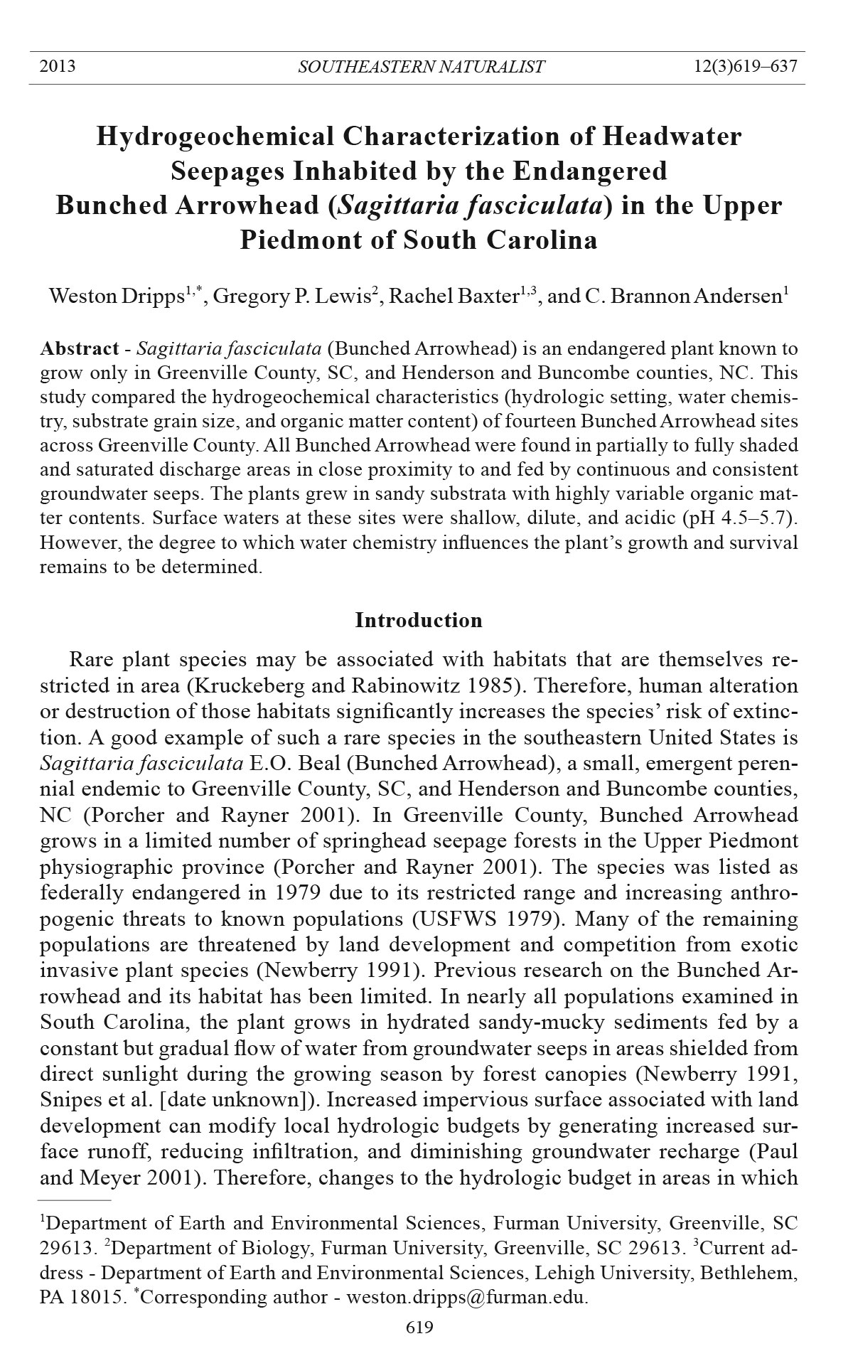
We examined all 14 of the Bunched Arrowhead sites known to exist in South
Carolina as of 2007 (Fig. 1). All of the sites occurred in northern Greenville
County. Eight of the sites were found within preserves managed by the South
Carolina Department of Natural Resources, one site was on the campus of Furman
University, and the remaining sites resided on private properties. The sites
all occurred within the headwaters of the Reedy and Enoree River drainages. In
this region, the predominant underlying bedrock is composed of granites and
gneisses (Overstreet and Bell 1965), which are relatively resistant to weathering
and thus yield low levels of dissolved constituents. As a result, stream waters in
the region typically have low conductivities (<100 μS/cm; Andersen et al. 2001,
Lewis et al. 2007).
Within the drainages containing the Bunched Arrowhead sites, the dominant
upland soils are mapped as well-drained sandy loams or clay loams in the Cecil,
Hiwassee, and Pacolet series (Camp 1975). The land in the immediate vicinity
of the Bunched Arrowhead populations was either forested or shrub/grass dominated
(Table 1). The land cover upgradient of the communities varied among
the sites and comprised different proportions of forest, shrubs, grasses, and/
or residential areas (Table 1). All sample sites occurred in low-lying saturated
depressions or in streams fed by groundwater seeps that were in close proximity
(≤10 m) to each Bunched Arrowhead population.
621
W. Dripps, G.P. Lewis, R. Baxter, and C.B. Andersen
2013 Southeastern Naturalist Vol. 12, No. 3
Methods
We visited each of the sites on two occasions, once during fall (October 24–
November 2) 2006, and again during winter (February 15–March 14) 2007. During
the fall visit at each site, we conducted a visual site assessment and collected
sediment samples. During both fall and winter visits, we conducted in situ water
quality measurements and collected water samples for chemical a nalyses.
Site assessments
The visual site assessment qualitatively characterized the hydrogeology
(i.e., degree of saturation, water depth, water velocity, topographic setting),
surrounding land cover (i.e., main vegetation type, degree of shading), and
general substrate composition. Water-depth measurements were made during
the fall sampling. A measurement was taken at the maximum and minimum
depth in which the Bunched Arrowhead plants were found growing within each
population. Flow rates at each site were categorized during the fall sampling as
“stagnant”, “near stagnant”, “low flow”, or “flow” depending on the observed
Figure 1. Location of the 14 Sagittaria fasciculata (Bunched Arrowhead) sites that were
sampled in Greenville County, SC. Each site is designated by a black circle with its respective
site number.
W. Dripps, G.P. Lewis, R. Baxter, and C.B. Andersen
2013 Southeastern Naturalist Vol. 12, No. 3
622
surface water movement through the population. Land cover was assessed visually
on site immediately surrounding each population, and aerial photographs
within Google Earth (Version 6) were used to characterize the land cover for the
upland drainage areas for each site.
Sediment sample collection and processing
A single 5.1-cm-diameter core sample of the upper 10 cm of substrate, the estimated
rooting depth of the Bunched Arrowhead, was collected from the middle of
each Bunched Arrowhead population for analyses of grain size and organic matter
content. We chose not to collect more than one sediment sample per population in
order to minimize damage to the plants and their habitats. Samples were dried at 60
°C for 2 days, and 50 g of each dried sample then was sieved using a 0.5-phi interval,
with mean grain size and sorting calculated in phi units (φ = -log2d, where d = grain
diameter) using the method of moments (Folk 1980). Also, two 1.5-g subsamples
of each dried sediment sample were combusted at 400 °C for 16 hours to determine
loss on ignition (LOI). A temperature of 400 °C (as opposed to a higher temperature)
was used to avoid dehyradation of clays and ferrihydrite so that our estimate of
percent organic matter would not be inflated by loss of water from the mineral fraction
of the samples (Heiri et al. 2001, Schumacher 2002). Therefore, we assumed
that LOI would be equivalent to percent organic matter in the sediments.
Water sample collection and analyses
During each visit to each location, we measured water temperature, dissolved
oxygen (DO) concentration using a YSI 55 meter, conductivity using a YSI 30
meter, and pH using a Fisher Scientific AP62 Accumet pH meter. Also, a single
surface-water sample was collected from each site at each visit using a pre-cleaned
Table 1. Summary of the site characteristics from the visual assessment for the 14 Sagittaria fasciculata
(Bunched Arrowhead) locations conducted during October–November 2006 in Greenville
County, SC. “On-site land cover” indicates the dominant vegetation in the immediate vicinity of
each Bunched Arrowhead population. “Upland land cover” indicates the dominant land cover
type(s) in the drainage basin of each site.
Site Water depth (cm) Water velocity On-site land cover Upland land cover
1 1–5 Near stagnant Shrub/grass Forest/residential
2 1–10 Near stagnant Shrub/grass Shrub/grass
3 7–12 Near stagnant Small trees (<1 m) Forest
4 1–3 Near stagnant Forest Forest/residential
5 1–2 Near stagnant Forest Forest/shrub
6 3 Low flow Forest Forest/shrub
7 7–10 Flow Forest Forest
8 1–7 Flow High grass (≈1 m) Shrub/residential
9 5 Flow Forest Forest/residential
10 1–5 Low flow Forest Forest
11 1–3 Low flow Forest Forest
12 1–5 Flow Forest Forest/residential
13 1–5 Flow Forest Forest/residential
14 1 Near stagnant Forest Grass
623
W. Dripps, G.P. Lewis, R. Baxter, and C.B. Andersen
2013 Southeastern Naturalist Vol. 12, No. 3
high-density polyethylene bottle which was rinsed three times with water from the
site before filling. Water samples were transported to the laboratory on ice and then
were filtered through 0.45-μm-membrane filters. An aliquot from each sample was
preserved with trace-metal-grade nitric acid for cation analysis, a second aliquot
was preserved with trace-metal-grade sulfuric acid for total dissolved nitrogen
(TDN) analysis, and a third aliquot was left unpreserved for dissolved organic carbon
(DOC), alkalinity, ammonium (NH4
+), and anion analyses.
Solute analyses were conducted as in Lewis et al. (2007). Anion concentrations
(F-, Cl-, Br -, H2PO4
-, NO2
-, NO3
-, and SO4
2-) were measured using a Dionex
120 ion chromatograph. Gran titration was used to measure alkalinity, from
which bicarbonate (HCO3
-) concentrations were calculated. Concentrations of
base cations (Na+, K+, Mg2+, Ca2+) and dissolved silicon (as Si4+) were measured
using a Varian 2000 ICP-AES. Total dissolved nitrogen concentrations were
measured with an O.I. Analytical Flow Solution IV autoanalyzer. Because of instrument
error, only samples from fall 2006 were analyzed for TDN. Ammonium
concentrations were measured using a Turner Designs 10-AU fluorometer, and
DOC concentrations were measured using a Tekmar-Dohrmann Phoenix 8000
total organic carbon analyzer. Charge balances for 21 of the total 28 samples were
within ±5%, and charge balances for the remaining 7 samples were within ±10%.
We estimated dissolved organic nitrogen (DON) concentration as TDN concentration
minus dissolved inorganic nitrogen (DIN) concentration (NH4-N +
NO3-N + NO2-N concentrations). Dissolved carbon dioxide (CO2(aq)) concentrations
were estimated using the procedure described in Lewis et al. (2007). We
calculated total dissolved carbon (TDC) concentrations as the sum of DOC and
dissolved inorganic carbon (DIC) concentrations (the sum of C from HCO3
- and
CO2(aq)). Partial pressure of CO2 dissolved in surface water at each site (PCO2)
was calculated from water temperature, pH, and HCO3
- concentrations using
methods modified from Andersen (2002). We also calculated PCO2 saturation,
the ratio of PCO2 in surface water to PCO2 in the atmosphere (Andersen 2002).
Statistical analyses
All statistical analyses were conducted using JMP 9.0.0 (SAS Institute, Inc.,
Cary, NC). Data were tested for normality using Shapiro-Wilk tests. For two-group
comparisons, equality of variances was checked using F-tests. For two-sample
tests, if data were normal but variances were unequal, independent-samples t-tests
assuming unequal variances were used. If data were not normal, Mann-Whitney
tests were used. We used these independent-samples tests to compare sites with
stagnant and flowing water within each of the two seasons. We also used independent-
samples tests to compare sites with forest and non-forest vegetative cover
within each season. We could not test for interactions between water flow and vegetation
cover using factorial analysis of variance because only one site fell into the
category of non-forest cover with flowing water.
For comparing data from repeated samplings of all 14 sites in fall and winter,
paired t-tests were used if the differences between the dates were normally distributed.
Otherwise, Wilcoxon signed rank tests were used. Correlations between
W. Dripps, G.P. Lewis, R. Baxter, and C.B. Andersen
2013 Southeastern Naturalist Vol. 12, No. 3
624
variables were conducted using Pearson’s correlations if both variables were
normally distributed and the relationships were linear. Otherwise, Spearman’s
rank correlations were used.
For solute concentrations which were below detection limits, we assigned
values of one-half of the detection limit for statistical purposes. This procedure
was used for analyses involving three variables: NH4
+ (<0.01 mg/L in 4 of
28 samples), NO3
- (<0.05 mg/L in 4 of 28 samples), and TDN (<0.1 mg/L in 4
of 14 samples).
Results
Vegetative cover and hydrologic conditions
Vegetation cover at the Bunched Arrowhead populations varied among sites
(Table 1). At ten of the populations, forest canopies shaded the plants. The remaining
four populations grew in more open shrub- or grass-dominated settings.
At those four sites, the shrubs or grasses provided some shade to the Bunched
Arrowhead populations during the growing season.
All sites were fully saturated with water present at the land surface during
both the fall and winter visits. The plants themselves were partially submersed,
growing in water depths that varied from 1 to 12 cm (Table 1). At six sites, the
water flow was nearly stagnant (Table 1). At the other eight sites, water was
flowing at very slow but observable rates. There was no significant relationship
in frequency of occurrence between vegetation cover (mature forest vs. other
covers) and water flow rate (stagnant vs. flowing) among the sites (Fisher’s exact
test: P = 0.24).
All of the sites appeared hydrologically stable with no observable field evidence
(stressed or disturbed vegetation, extensive erosion or deposition, or flood
debris) that they had been recently subjected to flooding or other hydrologic disturbance.
Based on visual inspection, an organic-rich layer of varying thickness
overlay sandy sediment at all sites.
Sediment characteristics
Sediments among the sites ranged from coarse to fine sands (mean phi values
of 0.47 to 2.69) that were poorly to very poorly sorted (sorting of ± 1.11 to 3.03
phi). The organic matter content ranged widely among sites from 0.8% to 33.1%
(mean = 10.7%, median = 7.2%). Percent organic matter correlated positively
with both mean grain size and sorting (Fig. 2). Thus, sites with more organic
matter also tended to be finer grained and more poorly sorted.
Percent organic matter in the sediment samples did not differ significantly
between flowing and stagnant sites (independent samples t-test: P = 0.13). However,
the percent organic matter at forested sites (mean = 7.4%, SE = 2.6%) was
significantly lower than that of non-forested sites (mean = 19.2%, SE = 4.1%)
(Figs. 2, 3). Stagnant and flowing sites did not differ significantly in either mean
grain size (t-test: P = 0.33) or sorting (t-test: P = 0.067). Mean grain size did not
differ significantly between forested and non-forested sites (t-test: P = 0.11), but
forested sites were significantly better sorted (Figs. 2, 4).
625
W. Dripps, G.P. Lewis, R. Baxter, and C.B. Andersen
2013 Southeastern Naturalist Vol. 12, No. 3
Figure 2. Relationships between sediment grain size, sorting, and percent organic matter at
14 seepages inhabited by Sagittaria fasciculata (Bunched Arrowhead) in Greenville County,
SC, October–November 2006. Both relationships were statistically significant (grain
size: Spearman’s rho = 0.82, P = 0.0004; sorting: Spearman’s rho = 0.95, P < 0.0001).
Figure 3. Sediment
organic matter content
of seepages
inhabited by Sagittaria
fasciculata
(Bunched Arrowhead)
in Greenville
County, SC,
October–November
2006. Forested
sites (n = 10) had
significantly (independent-
samples
t-test, P = 0.032)
lower organic matter
content than did
non-forested sites
(n = 4). The solid
horizontal line within each box represents the median, and the dashed horizontal line
represents the mean. The lower and upper limits of the boxes represent the 25th and 75th
percentiles, respectively. Whiskers represent the 10th and 90th percentiles. Filled circles
represent values beyond the 10th and 90th percentiles.
W. Dripps, G.P. Lewis, R. Baxter, and C.B. Andersen
2013 Southeastern Naturalist Vol. 12, No. 3
626
Surface water properties
Overall, surface waters at the 14 sites were poorly to very well oxygenated
(DO = 1.6–10 mg/L), acidic (pH = 4.5–5.7), and dilute (conductivity < 53 μs/cm).
In general, the surface waters exhibited a sodium-bicarbonate ion composition
or a mixed cation-bicarbonate composition with a high proportion of dissolved
silicon (Fig. 5). Typically, nutrient concentrations were low. For example, H2PO4
-
concentrations were <0.10 mg/L for all samples, NH4
+ concentrations were ≤0.06
Figure 4. Sediment
sorting in
seepages inhabited
by Sagittaria
fasciculata
(Bunched Arrowhead)
in Greenvi
l le County,
South Carolina,
October–November
2006. The
means of the two
groups differed
significantly (ttest:
P = 0.031;
sample sizes: forested
n = 10, nonforested
n = 4). The solid horizontal line within each box represents the median, and
the dashed horizontal line represents the mean. The lower and upper limits of the boxes
represent the 25th and 75th percentiles, respectively. Whiskers represent the 10th and 90th
percentiles. Filled circles represent values beyond the 10th and 90th percentiles.
Figure 5. Solute compositions of water samples collected at 14 seepages inhabited by
Sagittaria fasciculata (Bunched Arrowhead) in Greenville County, SC, October–November
2006 (“Fall 2006”) and February–March 2007 (“Winter 2007”).
627
W. Dripps, G.P. Lewis, R. Baxter, and C.B. Andersen
2013 Southeastern Naturalist Vol. 12, No. 3
mg/L in all but one sample, NO2
- concentrations were all <0.08 mg/L, and NO3
-
concentrations were <1 mg/L in 21 of 28 samples. However, at site 8, NO3
- concentrations
were ≈6 mg/L in both seasons.
Overall, oxidized N species were the dominant dissolved N species (>50%
NO3 + NO2) at sites with actively flowing water, whereas DON was the dominant
N species (>70% DON) at the stagnant sites (Fig. 6). Dissolved C was
predominantly CO2 (aq) at all sites (>81% for all samples; Fig. 7), with CO2 partial
pressures that were 48 to almost 500 times atmospheric pressure.
Across all sites, pH and DO were significantly higher in winter than in fall
(Table 2). Water temperature, conductivity, and concentrations of base cations,
Si, HCO3
-, DOC, and CO2(aq) were significantly higher in fall than in winter.
However, concentrations of other anions and of NH4
+ did not differ significantly
between seasons.
We found significant differences in concentrations of four solutes between
forest and non-forest sites (Table 3). Mean HCO3
- concentrations were ≈2 times
higher at forest than non-forest sites in fall. However, means did not differ significantly
in winter. Median SO4
2- concentrations were nearly 8 times higher at
non-forest sites compared to forest sites in fall, but the medians did not differ
significantly in winter. Median F- concentrations were about 3 times higher in
non-forest sites during the winter, but not in fall. Only in the case of dissolved
Si was the difference between forest and non-forest sites consistent in both seasons,
with Si concentrations 1.8 to 2.0 times higher at forest than non-forest sites
(Table 3, Fig. 8).
Figure 6. Proportions
of dissolved
nitrogen species in
surface water samples
from 14 seepages
(6 with stagnant
or near-stagnant water
velocity and 8
with visibly flowing
water) inhabited by
Sagittaria fasciculata
(Bunched Arrowhead)
in Greenville
County, SC, October
24–November 2
2006.
W. Dripps, G.P. Lewis, R. Baxter, and C.B. Andersen
2013 Southeastern Naturalist Vol. 12, No. 3
628
Figure 8. Dissolved
silicon (Si) concentrations
at seepages
inhabited by Sagittaria
fasciculata
(Bunched Arrowhead)
in Greenville
County, SC, in fall
2006 (October 24–
November 2) and
winter 2007 (February
15–March 14).
Of 14 sampling locations,
10 had forest
canopy cover
(“forested”) and the
remaining 4 were
dominated by shrubs and/or grasses (“non-forested”). A single water sample was collected
at each site in each season. The solid horizontal line within each box represents the median,
and the dashed horizontal line represents the mean. The lower and upper limits of the boxes
represent the 25th and 75th percentiles, respectively. Whiskers represent the 10th and 90th
percentiles. Filled circles represent values beyond the 10th and 90th percentiles. Means of
the “forested” and “non-forested” groups differed significantly (P < 0.05) in both seasons.
Flowing sites had significantly higher Na+, NO3
-, and Si concentrations than
did stagnant sites in both seasons (Table 4). In other cases, significant differences
Figure 7. Proportions
of dissolved
carbon species
in surface water
samples from 14
seepages inhabited
by Sagittaria fasciculata
(Bunched
Arrowhead) in
Greenville County,
SC, in fall 2006
(October 24–November
2) and winter
2007 (February
15–March 14).
629
W. Dripps, G.P. Lewis, R. Baxter, and C.B. Andersen
2013 Southeastern Naturalist Vol. 12, No. 3
Table 2. Selected physical and chemical properties of surface waters at seepages inhabited by
Sagittaria fasciculata (Bunched Arrowhead) in Greenville County, SC. Fall samples were October–
November 2006; winter samples were collected February–March 2007 (n = 14 for each season).
Values are either means ± SE (for normally distributed variables) or medians with interquartile
ranges. Units of measurement are mg/L except for pH or as noted.
Variable Season Values
Temperature (°C) Fall 11.7 ± 1.86W, **
Winter 9.2 ± 0.6
pH Fall 4.96 ± 0.07T, **
Winter 5.23 ± 0.08
Dissolved O2 Fall 4.4 ± 0.6W, **
Winter 6.6 ± 0.5
Conductivity† Fall 41.7 (37.5, 49.9)T, ***
Winter 31.1 (26.4, 37.3)
Na+ Fall 2.57 ± 0.25T, *
Winter 2.27 ± 0.21
K+ Fall 0.82 (0.68, 1.13)W, **
Winter 0.50 (0.29, 0.67)
Ca2+ Fall 2.20 (1.57, 2.69)W, ***
Winter 1.39 (0.78, 1.61)
Mg2+ Fall 1.02 ± 0.08T, ***
Winter 0.67 ± 0.05
Si4+ Fall 5.87 ± 0.52T, **
Winter 4.96 ± 0.55
NO3
- Fall 0.19 (0.09, 0.52)T, NS
Winter 0.49 (0.08,1.44)
Cl- Fall 3.01 (2.16, 3.47)W, NS
Winter 2.42 (2.02, 2.86)
SO4
2- Fall 0.69 (0.36, 1.37)W, NS
Winter 0.54 (0.40, 0.92)
F- Fall 0.04 (0.02, 0.09)W, NS
Winter 0.02 (0.02, 0.04)
HCO3
- Fall 9.36 ± 1.08T, **
Winter 5.59 ± 0.72
DOC Fall 3.33 (1.74, 4.66) W, ***
Winter 0.88 (0.66, 1.67)
CO2(aq) Fall 88.6 (54.2, 106.0)T, ***
Winter 23.6 (16.4, 35.7)
†Specific conductivity (μS/cm) at 25 °C.
WWilcoxon signed rank test.
TPaired t-test.
NSP > 0.05.
*P ≤ 0.05.
**P ≤ 0.01.
***P ≤ 0.001.
W. Dripps, G.P. Lewis, R. Baxter, and C.B. Andersen
2013 Southeastern Naturalist Vol. 12, No. 3
630
Table 3. Comparisons of solute concentrations (in mg/L) in Sagittaria fasciculata (Bunched Arrowhead)
seepage habitats with either forest or non-forest vegetative cover in Greenville County,
SC. Of 14 sampling locations, 10 had forest canopy cover (“Forested”) and the remaining 4 were
dominated by shrubs and/or grasses (“Non-forested”). A single water sample was collected at each
site in each season. Fall samples were collected between October and November 2006; winter
samples were collected between February and March 2007. Values are either means ± SE (for variables
which were normally distributed) or medians with interquartile ranges for variables which
were not normally distributed.
Variable Cover Fall Winter
F- Forested 0.04 (0.03, 0.13)M, NS 0.02 (0.02, 0.02)M, **
Non-forested 0.04 (0.03, 0.10) 0.06 (0.04, 0.32)
HCO3
- Forested 11.04 ± 1.05T, ** 5.63 ± 0.85T, NS
Non-forested 5.18 ± 1.08 5.50 ± 1.56
SO4
2- Forested 0.54 (0.30, 0.87)M,* 0.47 (0.40, 0.92)M, NS
Non-forested 4.03 (0.76, 14.17) 0.77 (0.23, 1.12)
K+ Forested 0.82 (0.50, 0.97)M, NS 0.44 (0.23, 0.57)T, *
Non-forested 1.05 (0.74, 1.91) 0.81 (0.49, 1.16)
Si4+ Forested 6.74 ± 0.43 T, ** 5.78 ± 0.49T, *
Non-forested 3.70 ± 0.70 2.92 ± 0.89
MMann-Whitney test.
TIndependent samples t-test.
NSP > 0.05.
*P ≤ 0.05.
**P ≤ 0.01.
***P ≤ 0.001.
were found only in one of the two seasons (Table 4). For example, flowing sites
had significantly higher water temperature and HCO3
- concentration in the fall,
but not in winter. Dissolved organic N concentrations were significantly lower
at flowing than stagnant sites in fall (no winter measurements were available).
There was a tendency for NH4
+ concentrations to be higher at stagnant than at
flowing sites, although the differences were not significant (fall: P = 0.053,
winter: P = 0.072) and in any case were low in magnitude (Table 4). In winter,
flowing sites had significantly higher pH, DO, and conductivity, but lower DOC
concentrations. For all other variables, there were no significant differences between
flowing and stagnant sites in either season (T able 4).
Discussion
Physical setting
Previous studies (Newberry 1991, Snipes et al. [date unknown]) have suggested
that Bunched Arrowhead requires seepage habitats characterized by
shallow, continuously flowing water. However, based on our field observations,
the plants are at least intermittently able to tolerate borderline stagnant water.
However, we do not have data on the growth rates of the populations visited, and
it is possible that the stagnant conditions at some sites were detrimental to the
631
W. Dripps, G.P. Lewis, R. Baxter, and C.B. Andersen
2013 Southeastern Naturalist Vol. 12, No. 3
plants. Newberry (1991) has suggested that reduction of water flow in Bunched
Arrowhead seepages by the invasive Murdannia keisak (Hassk.) Hand.-Mazz.
(Asian Spiderwort) enhances siltation of the seepages and allows for establishment
of other plant species that may hinder the survival of Bunched Arrowhead.
Although most of the Bunched Arrowhead populations we studied grew under
forest canopies, some populations grew in shrub or grass-dominated environments.
Even in those settings, the Bunched Arrowhead received shade from taller
Table 4. Physico-chemical properties of surface waters in Bunched Arrowhead (Sagittaria fasciculata)
seepage habitats with either visible flow or stagnant waters in Greenville County, SC. Eight locations
had visible water flow (“flowing”); the remaining 6 had stagnant water (“stagnant”). A single
water sample was collected at each site in each season. Fall samples were collected October–November
2006; winter samples were collected February– March 2007. Values are either means ± SE (normally
distributed variables) or medians with interquartile ranges (variables not normally distributed).
Units of measurement are mg/L unless otherwise noted. ND = not determined.
Variable Flow rate Fall Winter
pH Flowing 5.04 ± 0.09T, NS 5.36 ± 0.08T, *
Stagnant 4.86 ± 0.10 5.05 ± 0.13
Temp. (°C) Flowing 12.2 (11.7, 13.8)M, * 8.5 (7.6, 10.6)T, NS
Stagnant 10.2 (9.2, 11.5) 10.5 (6.9, 11.5)
Dissolved O2 Flowing 4.8 ± 0.8T, NS 7.5 ± 0.6T, *
Stagnant 3.9 ± 1.0 5.5 ± 0.6
Conductivity† Flowing 45.1 (39.0, 51.0)M, NS 36.5 (30.7, 43.6) t**
Stagnant 38.5 (35.6, 48.7) 25.1 (21.3, 30.6)
HCO3
- Flowing 11.23 ± 1.46T, * 6.22 ± 0.92T, NS
Stagnant 6.88 ± 0.97 4.76 ± 1.14
DOC Flowing 1.92 (0.90, 3.09)M, * 0.71 (0.57, 0.87) m*
Stagnant 4.67 (3.39, 8.17) 1.61 (1.08, 2.27)
Na+ Flowing 3.09 ± 0.29T, ** 2.76 ± 0.24T, **
Stagnant 1.87 ± 0.21 1.62 ± 0.14
Si4+ Flowing 6.93 ± 0.57T, * 6.03 ± 0.56T, *
Stagnant 4.47 ± 0.58 3.53 ± 0.72
NO3
- Flowing 0.35 (0.16, 1.92)M, * 1.26 (0.62, 1.55) m**
Stagnant 0.08 (0.03, 0.21) 0.18 (0.04, 0.36)
NH4
+ Flowing 0.02 (0.01, 0.03)T, NS 0.02 (0.01, 0.03)M, NS
Stagnant 0.03 (0.02, 0.05) 0.03 (0.02, 0.07)
DON Flowing 0.02 (BD, 0.03)M, ** ND
Stagnant 0.16 (0.09, 0.58) ND
†Specific conductivity (μS/cm) at 25 °C.
MMann-Whitney test.
TIndependent samples t-test.
NSP > 0.05.
*P ≤ 0.05.
**P ≤ 0.01.
***P ≤ 0.001.
W. Dripps, G.P. Lewis, R. Baxter, and C.B. Andersen
2013 Southeastern Naturalist Vol. 12, No. 3
632
vegetation, and water temperatures did not differ significantly between forest and
non-forest sites in either fall or winter. It is possible that non-forest sites might
have higher water temperatures than forest sites in summer months. On the other
hand, proximity of the seeps inhabited by the Bunched Arrowhead to groundwater
sources might minimize differences in water temperature between forest and
non-forest sites. Additional research is needed to determine if the degree of canopy
cover influences survival of Bunched Arrowhead populations either directly (in
terms of light intensity) or indirectly (through effects on temperature). Lack of
canopy shading may not necessarily be detrimental to the plant, however. Baugh
and Schlosser (2012) report that removal of the overhead canopy at Bat Fork Bog
in North Carolina initiated flowering and faster growth in a population of Bunched
Arrowhead that had previously been shaded by exotic woody vegetation.
The organic matter content of the sediments at our sample sites (0.8% to
33.1%) overlaps with the range (8.4% to 19.1%, median = 12.6%) reported by
Snipes et al. [date unknown] for Bunched Arrowhead sites in the Enoree and
Reedy River drainages that were included in our study. However, Snipes et al.
[date unknown] reported that the organic matter content of the sediment at their
site in Henderson County, NC (n = 3 samples, range = 20–57%, median = 29%),
was higher than at the South Carolina sites. The reason for this difference was
unclear. In our study, the greater organic matter content of sediments at nonforest
sites might reflect higher productivity and detritus production of grasses
and other herbaceous plants in high-light environments lacking forest canopies.
Given that we collected only one sediment sample from each site, we do not know
how much spatial variability in sediment characteristics occurred within each
site. However, each Bunched Arrowhead population occupies a small area (less
than ≈2 m2), and the populations as a whole reside in similar geomorphic settings.
Surface-water characteristics
Generally, the proportions of ions and other solutes in the seepages were similar
to proportions in streams in the Upper (Inner) Piedmont (Andersen et al. 2001,
Lewis et al. 2007). However, the seepages had relatively low conductivity (13–52
μs/cm) and lower pH (less than 5.8) compared to levels typically found in those streams
(conductivity = 20–80 μs/cm, pH = 5.8–7.2). Given the small drainage areas of
the seeps, we speculate that the groundwater entering the seeps follows relatively
short flowpaths, which would provide limited time for dilute infiltrating rainwater
to accumulate ions from minerals in the soil and bedrock before discharging at
the surface and would account for the observed low ion concentrations. The seepages
also occurred in drainages with limited developed land cover, which tends to
increase conductivity and solute concentrations in Piedmont streams (Andersen
et al. 2001, Lewis et al. 2007, Muthukrishnan et al. 2007). It is unclear whether
residential land cover within the drainages of six of the sites influenced water
chemistry of the seeps. On one hand, the sites (8 and 9) with the highest NO3
-
concentrations and conductivity occurred within drainages in which residential
land cover was present. On the other hand, the sites with the second highest NO3
-
633
W. Dripps, G.P. Lewis, R. Baxter, and C.B. Andersen
2013 Southeastern Naturalist Vol. 12, No. 3
concentrations, second highest conductivity, and highest SO4
2- concentrations (2,
3, and 6, respectively) occurred in drainages without residential land cover.
CO2 generated by microbial and root respiration both in soils and in the seeps
themselves may have contributed to the limited acid neutralizing capacity of the
bedrock as well as the low pH of the surface waters. Dissolution of CO2 in water
produces carbonic acid, which can increase the acidity of both groundwater and
surface waters. In fact, PCO2 saturation in the seeps during fall (150–490 times
atmospheric partial pressure) was considerably higher than summer PCO2 saturation
in stream waters within the nearby Big Brushy Creek watershed (values up to
≈150), also located in the Upper Piedmont (Lewis et al. 2007). Because the seeps
are located at or near points of groundwater discharge, CO2 in the groundwater
would have had little time to out-gas, as compared to downstream reaches of
streams (Dawson et al. 1995, Johnson et al. 2008). Thus, such headwater seeps
could be important sites for out-gassing of CO2 from groundwater (e.g., Johnson
et al. 2008).
The higher CO2 concentrations and lower pH in the seeps in fall compared
to winter is consistent with higher rates of respiration that would occur during
warmer months. Further, DOC concentrations in the seeps were higher in fall
than in winter, perhaps due to higher rates of DOC release from decomposing
organic matter during the warmer months. Organic acids (a component of total
DOC) released during decomposition could also contribute acidity to the surface
waters (David et al. 1992, Driscoll et al. 1989).
For solutes derived primarily from or associated with mineral dissolution
(base cations, Si, and HCO3
-), concentrations in fall were higher than in winter.
Ratios of fall to winter mean or median solute concentrations ranged from about
1.1 to 1.7 (Table 2). Similarly, median specific conductance in the fall (41.7 μS/
cm) was 1.3 times higher than in winter (31.1 μS /cm). We hypothesize that seasonal
variation in evapotranspiration (Et) within the seepages’ catchments would
account for much of this variation in water chemistry. With lower Et in winter
(with dormancy of deciduous trees), groundwater would become more dilute
chemically as more precipitation water recharges the water table and hydrologic
residence times in the groundwater system are shorter. Although we did not make
quantitative measurements of seep discharges, the observed flow appeared to be
modestly higher during winter, consistent with lower rates of Et in the drainage
basins. In contrast to base cations, Si, and HCO3
-, the fall/winter ratios of median
DOC and CO2(aq) concentrations were 3.78 and 3.75, respectively, likely a result
of biological activity (e.g., release of DOC from decomposing organic matter)
that is higher under the warmer fall conditions.
Why concentrations of anions other than HCO3
- did not differ significantly
between seasons is uncertain, though the lack of difference may reflect processes
other than mineral dissolution (e.g., biological influence or anion exchange with
soils). Although not statistically significant, median Cl-, F-, and SO4
2- concentrations
tended to be higher in fall than winter (Table 2), consistent with the trends
in HCO3
-, base cations, and Si. Seasonal changes in NO3
- concentrations were
W. Dripps, G.P. Lewis, R. Baxter, and C.B. Andersen
2013 Southeastern Naturalist Vol. 12, No. 3
634
highly variable among sites, with concentrations increasing from fall to winter at
8 sites, but decreasing from fall to winter at 5 sites.
Although NO3
- concentrations did not change consistently by season among
the sites, the influence of water flow rates on the nitrogen biogeochemistry of the
seep waters was evident. For example, compared to sites with visibly flowing
water, stagnant sites had lower concentrations of DO and NO3
- and higher DON
concentrations. With longer residence time of water in the seeps, the potential for
biological oxygen consumption would increase. Although none of our measurements
indicated the surface waters were anoxic at those times, anoxic conditions
in the sediments (in combination with available organic matter) would have allowed
denitrification to remove NO3
- from surface waters (Harrison et al. 2011,
Herrman and White 2008, Peterson et al. 2001), especially in the stagnant sites.
In the stagnant sites, DON (rather than NO3
-) was the predominant form of dissolved
N, accounting for 68–95% of TDN (in contrast to accounting for 0–43%
of TDN at flowing sites). Ammonium concentrations were low at nearly all sites,
possibly because of efficient uptake of NH4
+ by plants and microbes and/or oxidation
of NH4
+ to NO3
- by nitrifying bacteria in the oxygenated surface waters.
Effective NH4
+ retention is typical of the biological systems of small headwater
streams in many regions (Peterson et al. 2001).
Other differences in water chemistry between stagnant and flowing sites were
evident as well. The lower pH of the stagnant sites may have been due to higher
concentrations of organic acids (as suggested by higher DOC concentrations in
the stagnant sites). Because concentrations of CO2(aq) did not differ significantly
between stagnant and flowing sites, differences in carbonic acid concentrations
would not account for the pH differences. Given that conductivity and concentrations
of HCO3
- and Na+ were lower at stagnant sites, it is also possible that
groundwater flowpaths differed between stagnant and flowing sites. If groundwater
entering sites with stagnant surface water had had less contact time with
soil and bedrock minerals, there may have been less opportunity for neutralization
of groundwater acidity and ion accumulation. The lower Si concentrations
in stagnant sites compared to flowing sites may reflect greater opportunity for Si
uptake by diatoms and graminoid plants (especially grasses and sedges) under
low-flow conditions. Previous studies have provided evidence that diatoms and
grasses can take up appreciable quantities of Si from surface waters in wetlands
(e.g., Borrelli et al. 2012, Ding et al. 2004, Struyf and Conley 2009). Silicon uptake
by diatoms and grasses may also explain the lower Si concentrations in the
non-forested sites. For example, in streams in Shenandoah National Park, VA,
Si concentrations declined after Porthetria dispar (L.) (Gypsy Moth) defoliated
trees along the streams, allowing more light to reach the streams and presumably
increasing diatom Si uptake (Grady et al. 2007).
Conclusions
This study represents the first comprehensive hydrogeochemical assessment
of the habitat of the endangered Bunched Arrowhead. Overall, surface waters in
the seep habitats were more acidic and dilute than stream waters in nearby areas
635
W. Dripps, G.P. Lewis, R. Baxter, and C.B. Andersen
2013 Southeastern Naturalist Vol. 12, No. 3
of the Upper Piedmont of South Carolina, probably reflecting the location of the
seeps in the upper headwaters of streams. However, additional research is needed
to determine if the Bunched Arrowhead’s survival is constrained to the range
of physical and chemical parameters measured at our sample sites. Among the
sites we studied, there was considerable variation in some physical and chemical
conditions (widely ranging dissolved oxygen and sediment organic matter concentrations,
as well as relatively high nitrate and sulfate concentrations at some
sites). Further, Snipes et al. [date unknown] reported studying one population of
Bunched Arrowhead in North Carolina that grew in sediments that were more
organic-rich than the sediments we sampled in South Carolina.
In spite of the variation in sediment characteristics and surface-water chemistry
among habitats, all Bunched Arrowhead populations we examined occurred
in shallow waters (≈70% of which had maximum depths ≤5 cm, and all were
<13 cm deep). We hypothesize that seepage hydrology exerts more influence
on Bunched Arrowhead growth and survival than does water chemistry, at least
under current conditions. Still, additional research is needed to examine the hydrologic
variability within the Bunched Arrowhead habitats. In contrast to our
study, Baugh and Schlosser (2012) report a population of Bunched Arrowhead
growing at depths of at least 1 m in a spring-fed pond along the Mills River,
NC. Additional research will be critical to determining the extent to which land
development (especially surface-water runoff and reduced groundwater recharge
associated with increasing impervious surface cover) threatens the long-term
survival of Bunched Arrowhead populations.
Also, to our knowledge, no previous studies have made detailed analyses
of the biogeochemistry of headwater springs and seeps in the South Carolina
Piedmont. Previous studies in other regions have identified the importance of
headwater streams to downstream water quality and nutrient dynamics (e.g., Alexander
et al. 2007, Peterson et al. 2001). Thus, understanding the physical and
biogeochemical processes (e.g., CO2 out-gasing and nitrogen retention and transformations)
that occur within springs and seeps such as those inhabited by the
Bunched Arrowhead will be important to understanding the function of stream
systems in the southeastern Piedmont.
Acknowledgments
We thank the South Carolina Department of Natural Resources (SC DNR) for access
to the field locations. We especially thank Mary Bunch (SC DNR), Amy Williams, and
Guinn Garrett for field assistance and Lori Nelsen for solute analyses. This research was
funded by Furman University and is a contribution of the River Basins Research Initiative
at Furman University.
Literature Cited
Alexander, R.B., E.W. Boyer, R.A. Smith, G.E. Schwarz, and R.B. Moore. 2007. The role
of headwater streams in downstream water quality. Journal of the American Water
Resources Association 43(1):41–59.
W. Dripps, G.P. Lewis, R. Baxter, and C.B. Andersen
2013 Southeastern Naturalist Vol. 12, No. 3
636
Andersen, C.B. 2002. Understanding carbonate equilibria by measuring alkalinity in
experimental and natural systems. Journal of Geoscience Education 50:389–403.
Andersen, C.B., K.A. Sargent, J. Wheeler, and S. Wheeler. 2001. Fluvial geochemistry
of selected tributary watersheds in the Enoree River Basin, SC. South Carolina Geology
43:57–71.
Baugh, T., and K.K. Schlosser. 2012. Management considerations for the restoration of
Bunched Arrowhead, Sagittaria fasciculata. Natural Areas Journal 33:105–108.
Borrelli, N., M. Osterrieth, A. Romanelli, M.F. Alvarez, J.L. Cionchi and H. Massone.
2012. Biogenic silica in wetlands and their relationship with soil and groundwater
biogeochemistry in the Southeastern of Buenos Aires Province, Argentina. Environmental
Earth Sciences 65(2):469–480.
Camp, W. 1975. Soil Survey of Greenville County, SC. US Department of Agriculture,
Washington, DC. 71 pp. + maps.
David, M.B., G.F. Vance, and J.S. Kahl. 1992. Chemistry of dissolved organic carbon and
organic acids in two streams draining forested watersheds. Water Resources Research
28(2):389–396.
Dawson, J.J.C., D. Hope, M.S. Cresser, and M.F. Billett. 1995. Downstream changes in
free carbon dioxide in an upland catchment from northeastern Scotland. Journal of
Environmental Quality 24(4):699–706.
Ding, T., D. Wan, C. Wang, and F. Zhang. 2004. Silicon isotope compositions of dissolved
silicon and suspended matter in the Yangtze River, China. Geochimica et
Cosmochimica Acta 68(2):205–216.
Driscoll, C.T., R.D. Fuller, and W.D. Schecher. 1989. The role of organic acids in the
acidification of surface waters in the eastern United States. Water, Air, and Soil Pollution
43(1–2):21–40.
Folk, R. 1980. The Petrology of Sedimentary Rocks. Hemphill Publishing Company,
Austin TX.184 pp.
Grady, A.E., T.M. Scanlon, and J.N. Galloway. 2007. Declines in dissolved silica concentrations
in western Virginia streams (1988–2003): Gypsy Moth defoliation stimulates
diatoms? Journal of Geophysical Research 112:G01009. Available online at doi:
10.1029/2006JG000251.
Harrison, M.D., P.M. Groffman, P.M. Mayer, S.S. Kaushal, and T.A. Newcomer. 2011.
Denitrification in alluvial wetlands in an urban landscape. Journal of Environmental
Quality 40:636–646.
Heiri, O., A.F. Lotter, and G. Lemke. 2001. Loss on ignition as a method for estimating
organic and carbonate content in sediments: Reproducibility and comparability of
results. Journal of Paleolimnology 25:101–110.
Herrman, K.S., and J.R. White. 2008. Denitrification in intact sediment cores from a
constructed wetland: Examining the isotope pairing technique. Applied Geochemistry
23:2105–2112.
Johnson, M.S., J. Lehmann, S.J. Riha, A.V. Krusche, J.E. Richey, J.P.H.B. Ometto,
and E.G. Couto. 2008. CO2 efflux from Amazonian headwater streams represents a
significant fate for deep soil respiration. Geophysical Research Letters 35:L17401.
Available online at doi: 10.1029/2008GL034619.
Kruckeberg, A.R., and D. Rabinowitz. 1985. Biological aspects of endemism in higher
plants. Annual Review of Ecology and Systematics 16:447–479.
Lewis, G.P., J. Mitchell, C.B. Andersen, D. Haney, M.-K. Liao, and K.A. Sargent. 2007.
Urban influences on stream chemistry and biology in the Big Brushy Creek watershed,
South Carolina. Water, Air, and Soil Pollution 182:303–323.
637
W. Dripps, G.P. Lewis, R. Baxter, and C.B. Andersen
2013 Southeastern Naturalist Vol. 12, No. 3
Muthukrishnan, S., G.P. Lewis, and C.B. Andersen. 2007. Chapter 24: Relationships
between land cover, vegetation density, and nitrate concentrations in streams of the
Enoree River basin, piedmont region of South Carolina, USA. Pp. 517–542, In D.
Sarkar, R. Datta, and R. Hannigan (Eds.). Concepts and Applications in Environmental
Geochemistry. Elsevier Press, New York, NY. 778 pp.
Newberry, G. 1991. Factors affecting the survival of the rare plant, Sagittaria fasciculata
E.O. Beal (Alismataceae). Castanea 56(1):59–64.
Overstreet, W.C., and H. Bell III. 1965. Geologic map of the crystalline rocks of South
Carolina. US Geological Survey Miscellaneous Geologic Investigations Map I-413, I
sheet, scale 1: 250,000. USGS, Washington, DC.
Paul, M.J., and J.L. Meyer, 2001. Streams in the urban landscape. Annual Review of
Ecology and Systematics 32:333–365.
Peterson, B.J., W.M. Wollheim, P.J. Mulholland, J.R. Webster, J.L. Meyer, J.L. Tank,
E. Marti, W.B. Bowden, H.M. Valett, A.E. Hershey, W.H. McDowell, W.K. Dodds,
S.K. Hamilton, S. Gregory, and D.D. Morrall. 2001. Control of nitrogen export from
watersheds by headwater streams. Science 292(5514):86–90.
Porcher, R.D., and D.A. Rayner. 2001. A Guide to the Wildflowers of South Carolina.
University of South Carolina Press, Columbia, SC. 551 pp.
Schumacher, B. 2002. Methods for the Determination of Total Organic Carbon (TOC) in
Soils and Sediments. United States Environmental Protection Agency, Las Vegas, NV.
Snipes, D.S., L.A. Sacks, J.A. Wylie, B.A. Israel, and S.E. Dawson. [Date unknown].
Hydrogeology of the Bunched Arrowhead. Technical Completion Report to Plant
Conservation Program of the North Carolina Department of Agriculture, Raleigh,
NC. 82 pp.
Struyf, E., and D.J. Conley. 2009. Silica: An essential nutrient in wetland biogeochemistry.
Frontiers in Ecology and the Environment 7(2):88–94.
US Fish and Wildlife Service (USFWS). 1979. Determination that Sagittaria fasciculata
is an endangered species. Federal Register 44:43700–43701.


 The Southeastern Naturalist is a peer-reviewed journal that covers all aspects of natural history within the southeastern United States. We welcome research articles, summary review papers, and observational notes.