Current Distribution, Relative Abundance, and Landscape-Level Habitat Associations of the Cerulean Warbler
(Setophaga cerulea) along the Lower Roanoke River in North
Carolina
John P. Carpenter and Jean Richter
Southeastern Naturalist, Volume 12, Issue 4 (2013): 723–737
Full-text pdf (Accessible only to subscribers.To subscribe click here.)
723
J.P. Carpenter and J. Richter
22001133 SOUTSoHuEthAeSaTsEteRrnN NNaAtTurUaRliAstLIST 1V2o(4l.) :1722,3 N–7o3. 74
Current Distribution, Relative Abundance, and Landscape-
Level Habitat Associations of the Cerulean Warbler
(Setophaga cerulea) along the Lower Roanoke River in North
Carolina
John P. Carpenter1,* and Jean Richter2
Abstract - Setophaga cerulea (Cerulean Warbler) has been inadequately monitored along
the Roanoke River in North Carolina since a breeding population was discovered there in
1972. Our objectives were to estimate the Cerulean Warbler’s current population size and
distribution along the river, and evaluate landscape habitat characteristics in the Roanoke
River Basin among areas used and unused by the same species. In May 2001 and 2011, we
surveyed for singing male Cerulean Warblers, primarily by boat, along approximately 160
km of the Roanoke River from Weldon to Williamston in northeast North Carolina. We
found Cerulean Warblers in three distinct groups along the Roanoke River during both survey
years; however, we detected at least 32.4% fewer males in 2011 (n = 23) than in 2001
(n = 34). The landscape within 500 m of areas used by Cerulean Warblers had significanlty
less crop cover, blackwater floodplain (i.e., swamp) forest, and variation in mean canopy
height than unused landscapes we surveyed. These same differences existed at distances up
to 1 km, but several additional dissimilarities became evident at this scale, including presence
of more evergreen plantations and a greater fragmentation of the dominant forested
land cover at used versus unused landscapes. We recommend continued monitoring of the
Cerulean Warbler along the Roanoke River, increased habitat protection, and encourage an
in-depth investigation into management strategies to sustain this population.
Introduction
In North Carolina, Setophaga cerulea Wilson (Cerulean Warbler) reaches
its highest density during the breeding season within the Blue Ridge ecoregion;
however, the species has also been encountered throughout the state in both the
Piedmont and Coastal Plain (Fig. 1). Although many records from the latter two
ecoregions are of a single bird encountered most likely during migration, territorial
Cerulean Warbler males were first identified within North Carolina’s coastal
plain along the Roanoke River in June 1972 (Lynch 1973). Subsequent boat surveys
during the mid-1970s and early 1980s along various portions of the river in
Halifax, Northampton, Bertie, and Martin counties produced estimates of at least
40 pairs (Lynch 1981, Parnell 1977). Lynch (1981) reported that approximately
80% of the Cerulean Warbler population occurred along a 60-km river segment
from Halifax to Palmyra in Halifax County. In 1992 and 1993, Sallabanks et al.
(2000) studied swamp and levee forest bird communities along a 150-km portion
of the lower Roanoke River from Halifax to Plymouth, and found Cerulean
1North Carolina Wildlife Resources Commission, 1751 Varsity Drive, Raleigh, NC 27606.
2US Fish and Wildlife Service, Roanoke River NWR, PO Box 430, Windsor, NC 27983.
*Corresponding author - john.carpenter@ncwildlife.org.
J.P. Carpenter and J. Richter
2013 Southeastern Naturalist Vol. 12, No. 4
724
Warblers only on upstream levee transects. More recent but less thorough surveys
of the river from Weldon to Halifax in June 1987, and from Weldon to NC Hwy
258 in late May 1999 resulted in 11 and 7 singing Cerulean Warbler males, respectively
(Davis 1999, LeGrand 1988).
The Roanoke population is highly isolated and separated by at least 345 km from
the nearest breeding group in the mountains of western North Carolina. Historically,
Cerulean Warblers bred along the Chickahominy River in Virginia, but are now
believed to have been extirpated from that area due to heavy residential development
near the river’s headwaters. Although recent expeditions have yet to confirm
the warbler’s presence, the middle portion of the Chickahominy is still considered
pristine and may support the species (B.D. Watts, College of William and Mary,
Williamsburg, VA, pers. comm.).
The Cerulean Warbler has experienced a population decline exceeding 4.0% per
year, or nearly 70% of its breeding population, in the eastern United States from
1966–2002 (Rich et al. 2004). More recent range-wide estimates suggest that the already
imperiled Cerulean Warbler’s status has worsened, with declines of 4.6% per
year from 2003–2008 and 8.9% from 2007–2008 (Ziolkowski et al. 2010). As is the
Figure 1. Approximate locations for total number (A) and month encountered (B) of adult
Cerulean Warblers in North Carolina from 1981–2010 (Cornell Lab of Ornithology 2011,
Fiala 2011).
725
J.P. Carpenter and J. Richter
2013 Southeastern Naturalist Vol. 12, No. 4
case for most wildlife, the Cerulean Warbler’s decline is attributed to the loss and
degradation of the habitats used throughout its life cycle, which during the breeding
season often consists of large forested tracts with tall deciduous trees (Hamel
2000a, b). Parasitism by the Molothrus ater Boddaert (Brown-headed Cowbird),
and shortened rotation periods of managed forests have also been cited as potential
contributing factors (Hamel 2000a, b). The Cerulean Warbler now receives limited
protection under both federal and state laws. The US Fish and Wildlife Service
(USFWS) included it on the Birds of Management Concern list (USFWS 2006), and
it is ranked as a special concern species by the NC Wildlife Resouces Commission
(NCWRC 2005).
Results from the breeding bird survey’s (BBS) roadside protocol offer little insight
into the health of the Cerulean Warbler population along the Roanoke River
floodplain, which occurs along remote stretches of the river and far from BBS
survey routes. As a result, it has been difficult to monitor the status of this population
consistently over time. Our study objectives were to 1) estimate the Cerulean
Warbler’s current population size and distribution along the lower Roanoke River
by surveying for singing males, and 2) compare landscape-level habitat characteristics
of areas used and unused by the target species to help explain the warbler’s
abundance and distribution patterns.
Study Area
We concentrated our efforts along roughly 160 km of the Roanoke River from
Weldon to the outlet of Conine Creek east of Williamston in northeast North
Carolina (Fig. 2). This area corresponds to the portion of the river surveyed during
the most recent and comprehensive census to date (Lynch 1981). The lower
Roanoke River basin is considered one of the most pristine examples of intact
bottomland forest in the eastern United States (Fig. 3; Townsend 2001) and also
supports some of the highest bird densities and avian species richness reported for
similar habitats (Sallabanks et al. 2000). Nonetheless, large portions of the basin
have been heavily influenced by human land uses and altered hydrology, the latter
of which greatly effects the distribution of plant species among the floodplains
(Townsend 2001).
The main habitats in our study area are classified as brownwater levee forests
(high, medium, and low subtypes), bottomland hardwoods (high, low, and
swamp transition subtypes), and cypress-gum swamp habitats (Schafale 2012).
The average upper canopy reaches a height of 30 m and is relatively continuous
throughout these communities (Sallabanks et al. 2000). The brownwater levee forest
high-subtype canopy is distinguished by Fraxinus pennsylvanica Marsh. (Green
Ash), Celtis laevigata Willd. (Sugarberry), Platanus occidentalis L. (American
Sycamore), Betula nigra L. (River Birch), Acer negundo L. (Boxelder), and Ulmus
americana L. (American Elm). Lindera benzoin (L.) Blume (Spicebush), Asimina
triloba (L.) Dunal (Pawpaw), Aesculus sylvatica W. Bartram (Buckeye), as well
as locally abundant Arundinaria gigantea (Walter) Muhl. (Cane), may be found
throughout the shrub layer (Lynch 1981). The brownwater bottomland hardwood
J.P. Carpenter and J. Richter
2013 Southeastern Naturalist Vol. 12, No. 4
726
high subtype occurs in areas where flooding is more prevalent, with Quercus spp.
(oaks), Carya spp. (hickories), and Liquidambar styraciflua L. (Sweetgum) replaced
by more water-tolerant species in the swamp transition subtype, including
Quercus laurifolia Michx. (Laurel Oak) and Taxodium distichum (L.) Rich. (Bald
Cypress) (Schafale 2012). Cypress-gum swamps (brownwater subtype) are flooded
for long periods and characterized by Nyssa aquatica L. (Water Tupelo), Nyssa
biflora Walter (Swamp Tupelo), and Bald Cypress, with very little to no mid- or
understory (Schafale 2012). Agricultural lands can be found in varying densities
Figure 2. Study area surveyed for Cerulean Warblers along the Roanoke River, NC, from
May 12–14 2001, and from May 14–15 and May 28–29 2011.
727
J.P. Carpenter and J. Richter
2013 Southeastern Naturalist Vol. 12, No. 4
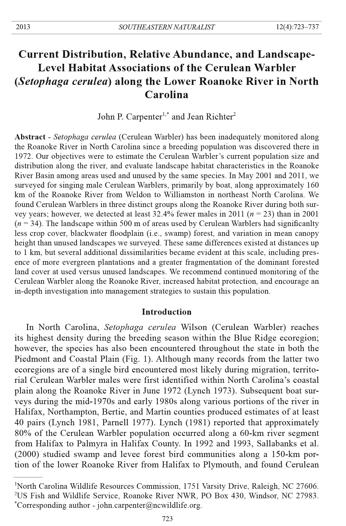
Figure 3. A segment of the Roanoke River (left) and habitat used by a Cerulean Warbler
male (right) near Weldon, NC, May 2011.
and sizes throughout the floodplains but are often restricted to higher elevated terraces
(Sallabanks et al. 2000).
Beginning in the early 1980s, The Nature Conservancy (TNC), USFWS, and
NCWRC began a major land-acquisition project encompassing over 36,400 ha
along the Roanoke River to protect the river’s floodplain forests and promote future
conservation efforts.
Methods
Bird surveys
We surveyed for singing Cerulean Warbler males from May 12–14 in 2001, and
May 14–15 and May 28–29 in 2011. Surveys were conducted primarily by boat,
and motors were occasionally used to quickly bypass areas that did not appear to
be suitable Cerulean Warbler habitat (e.g., cleared fields, forest stands with low
canopy heights). Several areas inaccessible by boat and adjacent to the river were
also investigated on foot. Although we attempted to mimic foot survey routes to
ameliorate comparison between years, not all areas surveyed in 2001 were revisited
in 2011, and some new locations were visited only in 2011.
Observations began at sunrise and ended at approximately 11:00 am; however,
a few surveys continued until 12:00–1:00 pm if birds were still actively singing.
Playback of a conspecific Cerulean Warbler song was periodically used to elicit
the response of males. In 2011, we revisited areas of concentrated Cerulean Warbler
activity during the second survey weekend and considered encounters independent
if the nearest singing neighbor was >200 m away (Robbins et al. 2010).
Recreational-grade global positioning system (GPS) units were used to record
approximate locations of Cerulean Warbler males. When possible, we recorded
locations directly beneath singing males; otherwise, GPS coordinates were taken
from boats nearby the birds.
Data analyses
Spatial distribution. Because of the Cerulean Warbler’s tendency to form colonylike
groups in some parts of its range (Hamel 2000a, b), we performed a 2nd-order
J.P. Carpenter and J. Richter
2013 Southeastern Naturalist Vol. 12, No. 4
728
point-pattern analysis using Ripley’s K function to determine if the population was
aggregated, uniform, or exhibited complete spatial randomness (CSR) over a range
of distances (Ripley 1976). We used PASSaGE version 2 to estimate K(d), which
is equal to the average number of points (i.e., locations of Cerulean Warbler males)
within a given distance (d) divided by the total number of points per unit area, or
λ = n / A (Rosenberg and Anderson 2011). We analyzed patterns up to 25% of the
maximum distance between points at 100-m intervals and used a weighted edge
correction to control for boundary edge effects (Diggle 1983, Haase 1995). A linear
transformation of K(d), known as L(d) and equal to √(K(d)/π) - d, was performed
to stabilize the variance whereby values >0 indicate clumping, values <0 indicate a
uniform distribution, and values equal to 0 indicate CSR (Hessburg et al. 2010). We
performed 499 randomized simulations to construct a 95% confidence envelope of
the observed patterns to create a new point pattern using the same number of points
but with random locations (Rosenberg and Anderson 2011).
Landscape associations. Landscape-level habitat characteristics, including
predominance of deciduous forest cover (Rodewald 2004, Thompson et al.
2012, Wood et al. 2006, but see McElhone et al. 2011), forest tract size (Hamel
et al. 2005, Robbins et al. 1989), and distance to mountaintop mining operations
(Weakland and Wood 2005), have been shown to influence the Cerulean Warbler’s
selection of breeding habitat. Therefore, to obtain a better understanding of their
macro-habitat requirements in the Roanoke River basin and to help ascertain
whether or not their populations are limited by the composition and configuration
of the surrounding landscape, we compared landscape features within areas used
and unused by Cerulean Warblers. We defined used habitat as GPS locations of
Cerulean Warbler males and unused habitat as randomly generated points placed
along the river within the study area where the species was not detected (Fig. 2).
We examined habitat at two scales by creating 500-m and 1-km buffers around
each location. We chose 500 m because it is a size at which many neotropical
species have been shown to associate significantly with at least one landscape
variable (Lichstein et al. 2002), and 1 km due to its use in other landscape studies
of Cerulean Warblers (Rodewald 2004, Weakland and Wood 2005). We calculated
the percentage of land-cover types and landscape-fragmentation metrics
(McGarigal and Marks 1995) using the Southeast Gap Analysis Project’s 2001
30-m2 land-cover data set (SEGAP; USGS 2008) and the ArcGIS extension Patch
Grid FRAGSTATS interface (ESRI 2008, Rempel et al. 2010). We also incorporated
18-m2 footprint light detection and ranging (LiDAR) data from the 2001 NC
floodplain mapping program (Newcomb and Mitasova 2009) to assess canopy
height and its variability across the landscape. We masked all hydrological areas
and removed values >60 m in height from the LiDAR data to ensure that no mamade
structures were included in the analysis. We included only sites where Cerulean
Warblers were detected in the 2001 survey because of the temporal similarity
with the spatial data.
All of our variables displayed skewed or bimodal distributions, and our attempts
to normalize them using logarithmic and square root transformations were
729
J.P. Carpenter and J. Richter
2013 Southeastern Naturalist Vol. 12, No. 4
unsuccessful. Therefore, we used Mann-Whitney U-tests to compare median values
of landscape variables from used and unused plots. All statistical analyses were
performed in SPSS® version 15 (SPSS, Inc. 2006), unless described elsewhere.
Results
We detected a total of 38 Cerulean Warbler males in 2001 and 24 (19 on May
14–15, and 5 on May 28–29) in 2011. When comparing only males encountered
along routes that were surveyed both years, we counted 34 and 23 Cerulean Warblers
in 2001 and 2011, respectively. More Brown-headed Cowbirds were detected
overall in 2001 (n = 137) than in 2011 (n = 63), and during encounters with Ceruelan
Warblers in 2001 (n = 20) than in 2011 (n = 3).
Cerulean Warblers were found in three distinct, spatially clustered groups along
the Roanoke River (Figs. 4, 5). The first group’s occurrence began near the town
of Weldon and extended to the south end of Mush Island where we detected 17
birds in 2001, one of which was an outlier roughly 11.5 km downstream, and 11
birds in 2011. The second group was in the vicinity of Buzzard’s Point with 10
birds detected in 2001 and 9 in 2011. The third group ranged from near Black Gut,
on Broadneck Swamp, to Poplar Point with 9 and 5 birds heard there in 2001 and
2011, respectively. Most singing Cerulean males were found in areas associated
with levee forests dominated by Green Ash, Sweetgum, American Sycamore, Acer
rubrum L. (Red Maple), and Acer saccharinum L. (Silver Maple).
Figure 4. Adjusted Ripley’s K (L[d]) for Cerulean Warbler distribution along the Roanoke
River. Values >0 indicate clumping, values <0 indicate a uniform distribution, and values
equal to 0 indicate complete spatial randomness (CSR).
J.P. Carpenter and J. Richter
2013 Southeastern Naturalist Vol. 12, No. 4
730
We detected differences between areas used and unused by Cerulean Warblers at
two different scales (Table 1). The landscape within 500 m of areas used by Cerulean
Warblers had significanlty less blackwater floodplain (i.e., canopy dominated
by Bald Cypress and Swamp Tupelo) forest (Z = -2.53, P < 0.01), less crop cover
(Z = -2.66, P < 0.01), and less variation in mean canopy height (Z = -3.41, P < 0.00)
Figure 5. Distribution of Cerulean Warbler males detected during surveys of the Roanoke
River in May 2001 and 2011. Land cover data from 2001 (top) and 2006 (bottom) National
Land Cover Database.
731
J.P. Carpenter and J. Richter
2013 Southeastern Naturalist Vol. 12, No. 4
Table 1. Comparisons of landscape metrics within 500 m and 1 km of locations used and unused by Cerulean Warbler males along the Roanoke River,
2001. Values are median (interquartile range) for Mann-Whitney U-tests. Basis of analysis was Southeast Gap Analysis Project’s 2001 land-cover data
set (USGS 2008). An “a” next to P-value indicates where differences significant exist at an alpha level ≤ 0.05.
500 m 1 km
Landscape variable Used Unused Z P Used Unused Z P
Fragmentation
Mean nearest neighbor (m) 73.1 (47.8) 70.1 (33.4) -0.11 0.91 75.0 (42.9) 77.5 (29.2) -0.03 0.98
Number of patches 53.0 (91.8) 69.5 (72.0) -0.80 0.42 175.5 (274.0) 210.0 (163.5) -0.27 0.79
Edge density (m/ha) 157.6 (195.1) 166.1 (146.8) -0.23 0.82 156.3 (164.4) 145.8 (116.6) -0.53 0.60
Shannon diversity index 1.5 (1.4) 1.6 (0.9) -0.34 0.74 1.6 (1.1) 1.6 (0.8) -0.27 0.79
Total core area (ha) 40.5 (34.5) 41.6 (23.7) -0.23 0.82 171.8 (120.2) 190.4 (80.6) -0.80 0.43
Largest patch index (%) 34.9 (40.1) 40.0 (21.0) -0.10 0.92 22.4 (41.8) 40.5 (22.4) -2.12 0.03a
Landscape shape index 4.6 (4.3) 4.8 (3.2) -0.19 0.85 8.0 (7.3) 7.6 (5.2) -0.53 0.60
Patch richness 12.5 (7.8) 12.5 (6.0) -0.69 0.49 15.0 (3.0) 15.0 (4.5) -1.22 0.22
Land cover
Dry mesic oak (%) 15.8 (37.5) 6.8 (13.1) -1.38 0.20 13.9 (29.1) 6.9 (12.9) -1.28 0.20
Mesic hardwood/mixed (%) 0.1 (1.7) 0.0 (2.2) -0.06 0.95 0.5 (2.3) 0.1 (2.6) -0.11 0.95
Peatland pocosin (%) 0.3 (1.8) 0.1 (1.1) -1.65 0.10 0.6 (1.6) 0.2 (1.1) -1.70 0.09
Blackwater floodplain (%) 0.0 (0.0) 0.0 (0.0) -2.53 0.01a 0.0 (0.0) 0.0 (0.0) -2.04 0.04a
Brownwater floodplain (%) 30.7 (77.9) 45.2 (46.5) -0.40 0.70 31.9 (66.4) 48.4 (50.8) -0.26 0.80
Pasture (%) 0.3 (1.0) 0.6 (1.8) -1.61 0.11 0.9 (2.6) 1.3 (2.8) -1.29 0.20
Crop (%) 1.6 (7.2) 8.2 (22.8) -2.66 0.01a 9.6 (17.6) 14.8 (20.0) -2.37 0.02a
Evergreen plantation (%) 1.5 (8.0) 0.5 (1.7) -1.32 0.19 5.2 (11.2) 0.7 (2.2) -2.28 0.02a
Clearcut (%) 0.0 (0.1) 0.0 (0.1) -0.72 0.47 0.1 (0.3) 0.0 (0.1) -1.80 0.07
Shrub/scrub (%) 0.1 (1.3) 0.3 (1.0) -0.30 0.77 0.5 (2.3) 0.4 (1.0) -0.37 0.71
High development (%) 0.0 (0.0) 0.0 (0.0) 0.00 1.00 0.0 (0.0) 0.0 (0.0) -0.04 0.97
Canopy
Height (m) 19.1 (16.3) 18.0 (8.2) -0.43 0.67 18.0 (13.8) 16.0 (6.4) -0.48 0.63
Maximum height (m) 36.5 (3.7) 36.8 (5.0) -0.93 0.36 39.2 (5.0) 38.5 (5.8) -1.07 0.28
Deviation in height (m) 7.9 (3.3) 10.1 (3.0) -3.41 0.00a 8.6 (3.2) 10.4 (2.9) -2.94 0.00a
J.P. Carpenter and J. Richter
2013 Southeastern Naturalist Vol. 12, No. 4
732
than unused landscapes. These same differences existed at distances up to 1 km;
however, used areas at this latter scale also had significanlty more evergreen plantations
(-2.28, P < 0.02) and greater fragmentation within the brownwater floodplain
forests (Largest Patch Index: Z = -2.12, P < 0.03). Dissimilarities between the two
landscapes also approached signficance at the 1-km scale in that used habitat had
more extensive peatland pocosin (Z = -1.70, P < 0.09) and clearcuts (Z = -1.80, P
< 0.07) than unused habitat.
Discussion
We detected 32.4% fewer Cerulean Warbler males in 2011 than in 2001 along
the lower Roanoke River of North Carolina. Recently, population declines have
been reported in several regions on the periphery of the Cerulean Warbler’s core
breeding range, including Ontario (Environment Canada 2011), northern Alabama
(J.P. Carpenter, pers. obs.), Maryland (P. Stango, Maryland Department of Natual
Resources, Annapolis, MD, pers. comm.), Delaware (Breeding Bird Atlas Explorer
2011), Connecticut (G. Krukar, Connecticut Department of Energy and Environmental
Protection, Hartford, CT, pers. comm.), and Oklahoma (Cavalieri et al.
2011). It has been asserted that changes in climate have altered the peak availability
of songbird prey, and that this mismatch in bird arrival and food quantity has caused
declines in bird populations (Both et al. 2006). Cerulean Warblers are considered
an early migrant, arriving at and departing from their breeding grounds before most
other wood-warbler species (Dunn and Garrett 1997). This adaptation constrains
them to typically raising only a single brood per season (Hamel 2000a), and, theoretically,
makes them more susceptible to reduced insect availability during this
contracted period when energy demand is high. We detected slight trends in warming
and reduced precipitation during the months April–August from 2001–2011
(Fig. 6; State Climate Office of North Carolina 2012); however, changes in mean
temperature (R2 = 0.31), number of days >35 °C (95 °F) (R2 = 0.11) and mean rainfall
(R2 = 0.09) were not significant. Although the decline suggested by our survey
results is troubling, the volume of noise produced by a periodical Magicicada spp.
(cicada) outbreak in 2011 may have drowned out distant male Cerulean Warbler
songs, and even Brown-head Cowbird songs, thereby affecting our estimates. Furthermore,
because it was difficult to standardize observer skill, float speeds, and
the use of playbacks, our ability to more accurately compare results between years
may have been compromised.
Clearly, Cerulean Warblers exhibited a clumped distribution along the Roanoke
River at several scales. This may not have always been the case because a large
portion of the segment of the Roanoke River most heavily used by Cerulean Warblers
in the mid- to late 1970s is now completely devoid of singing males. In 2001,
we conducted a crude habitat evaluation along the river and documented numerous
clearcuts with minimal riparian buffers (J. Richter, unpubl. data). This loss of hardwood
levee forest, primarily along the Occoneechee Neck, would have occurred
outside of the time period during which we conducted our landscape analysis, but
733
J.P. Carpenter and J. Richter
2013 Southeastern Naturalist Vol. 12, No. 4
may now be represented by the greater percentage of row-crop cover present in
unused areas throughout the floodplain and toward the upland.
We detected relatively few differences in the composition and configuration of
landscape metrics between areas used and unused by Cerulean Warblers. As described
earlier, the forested habitats directly adjacent to the Roanoke River are more
diverse than the single cover-type (i.e., brownwater floodplain forest) depicted in
the SEGAP schema that dominated our study area. The ecotone between a levee
forest and tupelo/cypress swamp, although less abrupt than that of a clearcut or
crop field, appears to also act as a barrier to Cerulean Warbler dispersal within our
study landscape and downstream beyond Williamston, NC. Cerulean Warblers have
demonstrated some resiliency to changing land-use practices and disturbances that
interrupt the contiguous forest cover they typically favor (Carpenter et al. 2011,
Jones et al. 2001, Rodewald 2004, Weakland and Wood 2005); nonetheless, uncertainty
remains regarding the threshold at which the birds can tolerate such alterations.
Within the lower Roanoke River basin, the combined presence of agriculture, evergreen
plantations, swamp forest and clearcuts, as well as a more highly variable
canopy height, suggests that the landscape farther away from currently occupied habitat
may not be suitable for establishment of additional territories, and further study
Figure 6. Mean maximum temperature, number of days >35 °C (95 °F), and mean rainfall
observed from April–August 2001–2011, at the NC Department of Agriculture’s Peanut
Belt Research Station in Lewiston, NC (36.13°N, 77.18°W).
J.P. Carpenter and J. Richter
2013 Southeastern Naturalist Vol. 12, No. 4
734
might yield insights into what the Cerulean Warblers’ thresholds of tolerance to disturbance
might be. While beyond the scope of this paper, the importance of smaller,
plot-level vegetation characteristics, such as canopy gaps and vertical structure, have
been suggested as more consequential to Cerulean Warbler habitat selection than the
quantity and arrangement of broad-scale features (McElhone et al. 2011).
According to Buehler et al. (2008), Cerulean Warblers in general, and especially
those in agriculturally-dominated landscapes, are unable to reliably
maintain stable populations because of high rates of nestling predation, brood
reduction, risks associated with long-distance migration, and loss of wintering
habitat. Therefore, we assume that the Roanoke River population is a sink,
where mortality outpaces reproduction or immigration, due to its small size,
restricted habitat availability, and geographic isolation. The potential of the
Cerulean Warbler population on the Roanoke River to reach 100 pairs (Hunter
et al. 2001) cannot be achieved without adequate monitoring, management, and
most importantly, increased habitat protection. We highly recommend consistent
monitoring in the Roanoke River basin to determine whether our results indicate
a truly persistent decline. We also recommend evaluation of microhabitat
features of sites used by the species, estimation of reproductive success, and an
investigation into management protocols used elsewhere, and their compatibility
for Cerulean Warbler management in the Roanoke River basin. Furthermore, additional
surveys for Cerulean Warblers are needed on other major waterways in
eastern North Carolina where suitable habitat may be present, such as the Meherrin,
Tar, and Neuse rivers, as well as Fishing and Swift creeks.
Acknowledgments
Funding for our study was provided by North Carolina State Wildlife Grants (SWG)
program of the USFWS. We especially thank Coastal Lumber Company and Brad Antil
for granting access to their property. We are indebted to many individuals who volunteered
their time to assist with these surveys: David Allen, Jack Baker, Brady Beck, Matt
Connolly, Derb Carter, Ed Corey, John Finnegan, Charlotte Goesche, Boyd Goss, Jeffrey
Hall, Elaine Hammond, John Hammond, John Hardister, Jeff Horton, Cynthia Janes,
Adam Johnson, Harry LeGrand, J. Merrill Lynch, Brian McLean, Nora Murdock, Eddie
Owens, Chuck Peoples, Johnny Parks, Will Rowland, Doak Wilkins, and John Wright.
Dr. Yong Wang graciously provided statistical assistance. The comments of two anonymous
reviewers and Ron Taylor were vital to the publication of this manuscript and are
greatly appreciated.
Literature Cited
Both, C., S. Bouwhuis, C.M. Lessells, and M.E. Visser. 2006. Climate change and population
declines in a long-distance migratory bird. Nature 441:81–83
Breeding Bird Atlas Explorer. 2011. US Geological Survey Patuxent Wildlife Research
Center and National Biological Information Infrastructure. Data compiled from:
Delaware Breeding Bird Atlas 2008–2012. Delaware Division of Fish and Wildlife,
Delaware Department of Natural Resources and Environmental Control. Interim results
used with permission. Available online at http://www.pwrc.usgs.gov/bba. Accessed 23
November 2011.
735
J.P. Carpenter and J. Richter
2013 Southeastern Naturalist Vol. 12, No. 4
Buehler, D.A., J.J. Giocomo, J. Jones, P.B. Hamel, C.M. Rogers, T.A. Beachy, D.W. Varble,
C.P. Nicholson, K.L. Roth,, J. Barg, R.J. Robertson, J.R. Robb, and K. Islam. 2008.
Cerulean Warbler reproduction, survival and models of population declines. Journal of
Wildlife Management 72:646–653.
Carpenter, J.P., Y. Wang, C. Schweitzer, and P.B. Hamel. 2011. Avian community and microhabitat
associations of Cerulean Warblers in Alabama. Wilson Journal of Ornithology
123:206–217.
Cavalieri, V.S., T.J. O’Connell, and D.M. Leslie, Jr. 2011. Cerulean Warbler occurrence and
habitat use in Oklahoma. Southeastern Naturalist 10:167–177.
Cornell Lab of Ornithology. 2011. eBird. Avian Knowledge Network. Ithaca, NY. Available
online at www.avianknowledge.net. Accessed 16 November 2011.
Davis, R. 1999. Briefs for the files. Chat 63:182–191.
Diggle, P.J. 1983. Statistical Analysis of Spatial Point Patterns. Academic Press, London,
UK. 148 pp.
Dunn, J.L., and K.L. Garrett. 1997. A Field Guide to Warblers of North America. Houghton-
Mifflin Co., Boston, MA.
Environment Canada. 2011. Management plan for the Cerulean Warbler (Setophaga cerulea)
in Canada. Species at risk act management plan series. Environment Canada,
Ottawa, ON, Canada.
Environmental Systems Research Institute (ESRI). 2008. ArcGIS. Version 9.3. Redlands, CA.
Fiala, K. 2011. Chat briefs for the files database. Available online at http://www.carolinabirdclub.
org/chat/database.html. Accessed 21 July 2011.
Haase, P. 1995. Spatial pattern analysis in ecology based on Ripley's K-function: Introduction
and methods of edge correction. Journal of Vegetation Science 6:575–582.
Hamel, P.B. 2000a. Cerulean Warbler status assessment. US Fish and Wildlife Service,
Minneapolis, MN.
Hamel, P.B. 2000b. Cerulean Warbler (Dendroica cerulea). In A. Poole and F. Gill (Eds.).
The Birds of North America, No. 511. The Birds of North America, Inc., Philadelphia,
PA.
Hamel, P.B., K.V. Rosenberg, and D.A. Buehler. 2005. Is management for Golden-winged
Warblers and Cerulean Warblers compatible? Pp. 322–331, In C.J. Ralph and T.D. Rich
(Eds.). Bird Conservation Implementation and Integration in the Americas: Proceedings
of the Third International Partners in Flight Conference, Volume 1. General Technical
Report PSW-GTR-191. USDA Forest Service, Pacific Southwest Research Station, Albany,
CA. 651 pp.
Hessburg, P.F., N.A. Povak, and R.B. Salter. 2010. Thinning and prescribed fire effects on
snag abundance and spatial pattern in an eastern Cascade Range dry forest, Washington,
USA. Forest Science 56:74–87.
Hunter, W.C., L. Peoples, and J. Collazo. 2001. Partners in Flight bird conservation plan for
the south Atlantic Coastal Plain (Physiographic Area #3). American Bird Conservancy,
The Plains, VA.
Jones, J., R. DeBruyn, J.J. Barg, and R.J. Roberston. 2001. Assessing the effects of a natural
disturbance on a neotropical migrant songbird. Ecology 82:2628–2635.
LeGrand Jr., H.E. 1988. Briefs for the files. Chat 52:63–70.
Lichstein, J.W., T.R. Simons, and K.E. Franzreb. 2002. Landscape effects on breeding songbird
abundance in managed forests. Ecological Applications 12:836–857.
Lynch, J.M. 1973. Cerulean Warbler found in North Carolina in summer. Chat 37:83–84.
Lynch, J.M. 1981. Status of the Cerulean Warbler in the Roanoke River Basin of North
Carolina. Chat 45:29–35.
J.P. Carpenter and J. Richter
2013 Southeastern Naturalist Vol. 12, No. 4
736
McElhone, P.M., P.B. Wood, and D.K. Dawson. 2011. Effects of stop-level habitat change
on Cerulean Warbler detections along breeding bird survey routes in the central Appalachians.
Wilson Journal of Ornithology 123:699–708.
McGarigal, K, and B.J. Marks. 1995. FRAGSTATS: Spatial pattern analysis program for
quantifying landscape structure. General Technical Report PNW-GTR-351. US Department
of Agriculture, Forest Service, Pacific Northwest Research Station, Portland, OR.
Newcomb, D.J, and H. Mitasova. 2009. Processing large LiDAR data sets for forest canopy/
landscape metrics Using 64-bit GRASS GIS. Oral Presentation, American Geophysical
Union Fall Meeting, San Francisco, CA, 14–18 December 2009.
North Carolina Wildlife Resources Commission (NCWRC). 2005. North Carolina wildlife
action plan. Raleigh, NC.
Parnell, J.F. 1977. Birds. Pp 330–384, In J.E. Cooper, S.S. Robinson, and J.B. Funderburg
(Eds.). Endangered and Threatened Plants and Animals of North Carolina, North Carolina
State Museum, Raleigh, NC.
Rich, T.D., C.J. Beardmore, H. Berlanga, P.J. Blancher, M.S.W. Bradstreet, G.S. Butcher,
D.W. Demarest, E.H. Dunn, W.C. Hunter, E.E. Inigo-Elias, J.A. Kennedy, A.M. Martell,
A.O. Panjabi, D.N. Pashley, K.V. Rosenberg, C.M. Rustay, J.S. Wendt, and T.C. Will.
2004. Partners in flight North America landbird conservation plan. The Cornell Lab of
Ornithology, Ithaca, NY.
Ripley, B.D. 1976. The second-order analysis of stationary processes. Journal of Applied
Probability 13:255–266.
Robbins, C.S., D.K. Dawson, and B.A. Dowell. 1989. Habitat area requirements of breeding
forest birds of the Middle Atlantic States. Wildlife Monographs 103:3–34.
Robbins, M.B., A.S. Nyari, M. Papes, B.W. Benz, and B.R. Barber. 2010. River-based
surveys for assessing riparian bird populations: Cerulean Warbler as a test case. Southeastern
Naturalist 9:95–104.
Rodewald, A.D. 2004. Landscape and local influences of forest management on Cerulean
Warblers in Pennsylvania. Pp. 472-477, In D.A. Yaussy, D.M. Hix, R.P. Long, and G.P.
Goebel (Eds.). Proceedings of the 14th Central Hardwood Forest Conference. General
Technical Report NE-316. USDA, Forest Service, Northeastern Research Station, Newtown
Square, PA. 539 pp.
Rosenberg, M.S., and C.D. Anderson. 2011. PASSaGE: Pattern Analysis, Spatial Statistics,
and Geographic Exegesis. Version 2. Methods in Ecology and Evolution 2:229–232.
Sallabanks, R., J.R. Walters, and J.A. Collazo. 2000. Breeding bird abundance in bottomland
hardwood forests: Habitat, edge, and patch size effects. Condor 102:748–758.
Schafale, M.P. 2012. Guide to the natural communities of North Carolina, 4th approximation.
North Carolina Natural Heritage Program, Department of Environment and Natural
Resources, Raleigh, NC.
SPSS Institute Inc. 2006. SPSS for Windows. Version 15.0. SPSS Institute Inc., Chicago, IL.
State Climate Office of North Carolina. 2012. NC CRONOS/ECONet Database, LEWS -
Peanut Belt Research Station, Lewiston, NC. Available online: http://www.nc-climate.
ncsu.edu/cronos. Accessed 31 January 2013.
Thompson III, F.R, M.B. Robbins, and J.A. Fitzgerald. 2012. Landscape-level forest
cover is a predictor of Cerulean Warbler abundance. The Wilson Journal of Ornithology
124:721–727.
Townsend, P.A. 2001. Relationships between vegetation patterns and hydroperiod on the
Roanoke River floodplain, North Carolina. Plant Ecology 156:43–5 8.
737
J.P. Carpenter and J. Richter
2013 Southeastern Naturalist Vol. 12, No. 4
US Fish and Wildlife Service (USFWS). 2006. 12-month finding on a petition to list the Cerulean
Warbler (Dendroica cerulea) as threatened with critical habitat. Available online
at http://www.fws.gov/midwest/eco_serv/soc/birds/cerw/cerwFR12mnth.pdf. Accessed
12 February 2012.
US Geological Survey National Gap Analysis Program (USGS). 2008. Southeast GAP Regional
Land Cover 2001. Biodiversity and Spatial Information Center, North Carolina
Cooperative Fish and Wildlife Research Unit, NC State University. Available online at
http://www.basic.ncsu.edu/segap/. Accessed 20 October 2011.
Weakland, C.A., and P.B. Wood. 2005. Cerulean Warbler (Dendroica cerulea) microhabitat
and landscape-level habitat characteristics in southern West Virginia. Auk 122:497–508.
Wood, P.B., S.B. Bosworth, and R. Dettmers. 2006. Cerulean Warbler abundance and occurrence
relative to large-scale edge and habitat characteristics. The Condor 108:154–165.
Ziolkowski, D.J., Jr., K.L. Pardieck, and J.R. Sauer. 2010. The 2003–2008 summary of the
North American breeding bird survey. Bird Populations 10:90–109.


 The Southeastern Naturalist is a peer-reviewed journal that covers all aspects of natural history within the southeastern United States. We welcome research articles, summary review papers, and observational notes.