Record Northernmost Endemic Mangroves on the United States Atlantic Coast with a Note on Latitudinal Migration
Asher A. Williams, Scott F. Eastman, Wendy E. Eash-Loucks,
Matthew E. Kimball, Michael L. Lehmann, and John D. Parker
Southeastern Naturalist, Volume 13, Issue 1 (2014): 56–63
Full-text pdf (Accessible only to subscribers.To subscribe click here.)
Southeastern Naturalist
A.Williams, S. Eastman, W. Eash-Loucks, M. Kimball, M. Lehmann, and J. Parker
2014 Vol. 13, No. 1
56
2014 SOUTHEASTERN NATURALIST 13(1):56–63
Record Northernmost Endemic Mangroves on the United
States Atlantic Coast with a Note on Latitudinal Migration
Asher A. Williams1,2,3,*, Scott F. Eastman1,2, Wendy E. Eash-Loucks1,4,
Matthew E. Kimball1,2,5, Michael L. Lehmann6, and John D. Parker7
Abstract - The northern limits of three mangrove species—Avicennia germinans (Black
Mangrove), Rhizophora mangle (Red Mangrove), Laguncularia racemosa (White Mangrove)—
on the United States Atlantic coast are vouchered and described in comparison to
previous boundaries defined in literature and herbarium collections. The location and general
status of individual trees were used to delineate northern maxima and show that present
ranges extend beyond historic records. The gradient structure of the ecotone within an area
of uniform climate is interpreted as ongoing latitudinal movement.
Introduction
Mangroves represent multiple taxa of tropical macrophytes that occupy coastal
margins and reproduce viviparously. Unique among wetland trees, mangroves facultatively
resist toxic osmotic gradients in saline soils by excluding and or excreting
excess salts (Snedaker and Snedaker 1984). Mangroves are further adaptive in aquatic
environments by dispersing viviparous propagules, rather than seeds, via surface
waters (e.g., tides, wind, currents) (Odum and McIvor 1990). Hydrologic conditions
(wave energy, freshwater influx, tidal prism, etc.) limit local habitat viability (Odum
and McIvor 1990), although thermal requirements generally restrict mangroves to
tropical and subtropical zones (Waisel 1972). Two biogeographic patterns reflect
fundamental ecology and adaptation in these organisms: decreased abundance along
latitudinal axes (Ellison et al. 1999), and lower species richness in the Americas as
compared with the Indo-Pacific (Macnae 1968). Productivity in mangrove swamps,
poised at the interface of the ocean, plays a disproportionately large role in global
carbon budgets (Bouillon et al. 2008). Furthermore, mangrove shorelines decrease
nutrient efflux from estuaries (Rivera-Monroy et al. 1999), stimulate food webs, and
provide habitat that enhances fisheries (Barbier 2000). Mangroves also form a physical
barrier that dampens wave energy, directly benefitting human coastal development
(Vermaat and Thampanya 2006, Zhang et al. 2012).
1Guana Tolomato Matanzas National Estuarine Research Reserve, 505 Guana River Road,
Ponte Vedra Beach, FL 32082. 2Department of Biological Sciences, University of North
Florida, 1 UNF Drive, Jacksonville, FL 32224. 3Department of Oceanography and Coastal
Sciences, Louisiana State University, Baton Rouge, LA 70803. 4King County Department
of Natural Resources and Parks, 201 S Jackson Street, Seattle, WA 98104. 5Baruch Marine
Field Laboratory, University of South Carolina, PO Box 1630, Georgetown, SC 29442.
6Smithsonian Marine Station, 701 Seaway Drive, Fort Pierce, FL 34949. 7Smithsonian Environmental
Research Center, PO Box 28, Edgewater, MD 21037. *Corresponding author
- awil336@tigers.lsu.edu.
Manuscript Editor: Joey Shaw
Southeastern Naturalist
57
A.Williams, S. Eastman, W. Eash-Loucks, M. Kimball, M. Lehmann, and J. Parker
2014 Vol. 13, No. 1
Three true mangrove species (Tomlinson 1995) are endemic to the United States
Atlantic coast: Avicennia germinans Jacq. (Black Mangrove), Rhizophora mangle
L. (Red Mangrove), and Laguncularia racemosa Gaertn. (White Mangrove). In
south Florida, mangrove swamps or “mangals” are classified within the riverinebasin-
fringe continuum (Lugo and Snedaker 1974) where dense tree assemblages
dominate intertidal habitat. Disparate freeze resilience causes an uneven latitudinal
boundary among the Florida endemics. For instance, by resprouting from roots,
Black Mangroves are less inhibited by occassional freezes compared to other species
(Odum and McIvor 1990). Morphologic development is impeded by cold stress
in the shrubby northern inhabitants, compared to the fully formed trees in south
Florida estuaries (Saenger and Snedaker 1993).
Precise northern boundary locations for each of the endemic species have proven
difficult to determine because of their transient nature, and ecologists have typically
delineated mangrove northern ranges along the Atlantic coast in general terms. For
instance, Savage (1972) limited Black Mangroves to no further than 30º N, and
Teas (1977) noted Reds and Whites do not extend beyond Ponce de Leon Inlet,
FL (29.10º N). The University of South Florida Institute of Systematic Botany
(hereafter USF), based on voucher specimens, lists the northernmost samples of
Black and White Mangroves at St. Augustine Inlet and Volusia County, FL, on the
United States Atlantic coast. The 1.5-m Black Mangrove specimen was vouchered
at 29º53.39'N, 81º17.41'W in early summer 2007 (Hansen 9825, USF; Wunderlin
and Hansen 2008). A less specific account of a White Mangrove at Daytona Beach
Shores, FL was discovered in an interdunal swale in 1962 (Ray 11136, USF; Wunderlin
and Hansen 2008). Zomlefer et al. (2006) represents the only published
account of a northernmost Red Mangrove, documented at Matanzas Inlet, FL
(29º42.94'N, 81º14.35'W) in a Spartina alterniflora Loisel (Smooth Cordgrass)
marsh with seven other individuals of the same species.
Community composition at climatic ecotones change in coincidence with thermal
regime (Buchner and Neuner 2011, D’Odorico et al. 2013), and one of the primary
distinguishing factors among biomes is climate. Mangrove transgression into temperate
salt marshes is a phenomenon that has been globally interpreted as a result of
changing climate, including studies in southeastern Australia (Saintilan and Williams
1999), the northeastern Gulf of Mexico (Comeaux et al. 2012), and Florida’s west
coast (Raabe et al. 2012). Evaluation of the Atlantic ecotone is ongoing, although
most accounts of a migration remain anecdotal, and only the location of an outlying
Red Mangrove has been formally vouchered (Zomlefer et al. 2006). Provided here
are the record locations and general morphology of the northernmost Black, Red, and
White Mangroves on the United States Atlantic coast and comparison with previous
northern distributions, verified in specimen collections and literature.
Methods
The Guana Tolomato Matanzas (GTM) estuary (Fig. 1) is located at the temperate
to subtropic climactic transition, in northeast Florida. The GTM estuary is a narrow
(east–west) and relatively shallow (average depth 2.7 m) tide-dominated lagoon with
two inlets (St. Augustine and Matanzas) connecting it to the Atlantic Ocean (ValleSoutheastern
Naturalist
A.Williams, S. Eastman, W. Eash-Loucks, M. Kimball, M. Lehmann, and J. Parker
2014 Vol. 13, No. 1
58
Levinson et al. 2009). Sediments are distributed in the channelized-estuary relative
to tidal forcing and maintenance dredging for navigation. Tides propagate through
the St. Augustine and Matanzas inlets, and flow direction is regulated by ebb and
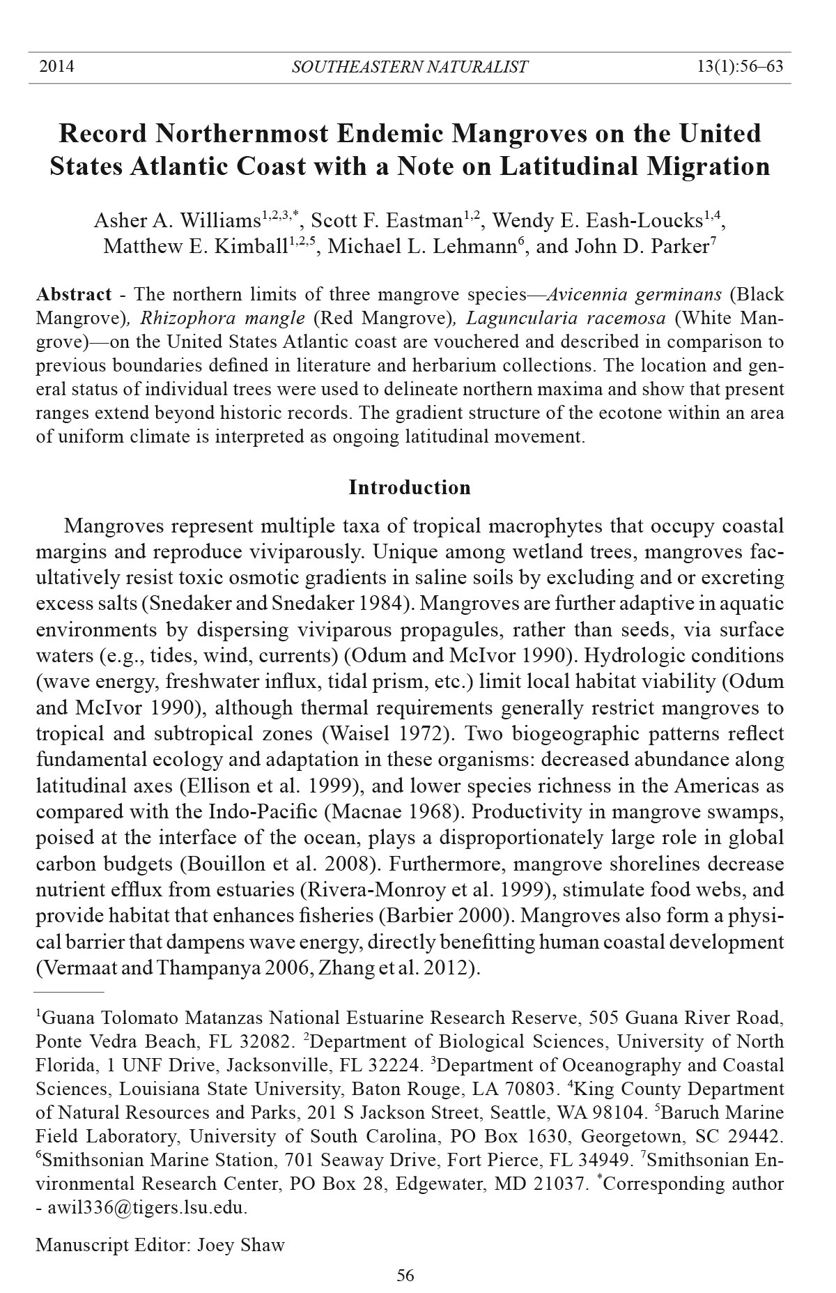
Figure 1. Map of the Guana Tolomato Matanzas estuary in northeast Florida showing locations
of the northernmost recorded Avicennia germinans (Black Mangrove), Rhizophora
mangle (Red Mangrove), and Laguncularia racemosa (White Mangrove) specimens on
the United States Atlantic coast.
Southeastern Naturalist
59
A.Williams, S. Eastman, W. Eash-Loucks, M. Kimball, M. Lehmann, and J. Parker
2014 Vol. 13, No. 1
flood. A water-control structure on the Guana River, in the upper estuary, and tidal
flux (e.g., hydrologic turnover) make GTM a marine-dominated system in which
water is transiently diluted by precipitation (Phlips et al. 2004). Mesotidal flow is
conserved in the system’s primary channel and does not form an extensive network of
tidal creeks. Laterally compressed geomorphology at GTM is noteworthy in two regards:
adjacent intertidal areas are all saline and they can be inspected almost entirely
from a boat. The Guana Tolomato Matanzas National Estuarine Research Reserve
(GTMNERR) includes the GTM, and as a result, the system is well monitored.
Seasonal sampling and surveys by GTMNERR personnel in the emergent intertidal
zone revealed that mangroves transitioned from absence to dominance along a
north-to-south gradient within a 35-km stretch of the estuary. The gradual structure
of an ecocline is applicable to mangrove latitudinal limits; however, the reference
to an ecotone made here is in recognition of a steep climactic scale. Observations
of northernmost individuals from all three endemic mangrove species were made in
2012 and early 2013, and each was evaluated in March 2013. We verified potential
outliers by walking transects oriented to the north and conducted at a vantage point
such that the entire marsh was visible. Travelling on foot, we scrutinized wetlands
5 km north of record locations, followed by verification and spot-checking by boat
of 17, 37, and 61 km north of the Black, Red, and White records, respectively.
Because Black Mangroves were abundant at the site of the northernmost Red and
White trees, we individually inspected plots of adjacent trees. We collected data on
height, diameter at 10 cm (hereafter D10), and canopy dimensions (long axis, perpendicular
short axis) for each plant. We made visual assessments of leaf chlorosis
(yellowing or browning) to determine plant status as healthy (0–33%), intermediate
(33–66%), or stressed (67–100%). We used a GPS unit, with 3-m accuracy, to
collect the coordinates of each record (provided as degrees and decimal minutes),
and took photographs for confirmation (Fig. 2). We described the vegetation in the
vicinity of each record mangrove for context. Hypothetical migration (km yr-1) was
calculated by the difference between previous and current observation locations
and year. The historic White Mangrove is approximated to 29º9.55'N, 80º58.28'W,
derived from the specimen description that included only the municipality. We provided
vouchers of each record tree to the USF Herbarium.
Results
Avicennia germinans
We recorded the northernmost Black Mangrove (Williams and Eastman s.n.,
USF) (Fig. 2) at 30º6.618'N, 81º22.303'W. The shrub was 86 cm in height, 3.5 D10,
with 145 x 93 cm canopy dimensions. Chlorosis was absent from leaf tissue, and
thus the plant was categorized as healthy. Another Black Mangrove was present in
the S. alterniflora marsh where the precisely northernmost individual was discovered,
10 m south of the record. The nearby shrub was also healthy in appearance
as yellow and browning were absent from leaves. The two trees were documented
in a marsh adjacent to the main channel of the GTM estuary in the Tolomato River
(Fig. 1). We collected data on 27 March 2013. However, the initial observations of
Southeastern Naturalist
A.Williams, S. Eastman, W. Eash-Loucks, M. Kimball, M. Lehmann, and J. Parker
2014 Vol. 13, No. 1
60
Figure 2. Photographs of the
northernmost Avicennia germinans
(Black Mangrove;
top), Rhizophora mangle
(Red Mangrove; center),
and Laguncularia racemosa
(White Mangrove; bottom)
specimens on the United
States Atlantic coast.
Southeastern Naturalist
61
A.Williams, S. Eastman, W. Eash-Loucks, M. Kimball, M. Lehmann, and J. Parker
2014 Vol. 13, No. 1
the tree were made in 2012. Black Mangroves were documented 27 km south of the
current location in 2007; therefore, hypothetical migration was 4.5 km yr-1.
Rhizophora mangle
We found the northernmost Red Mangrove (Williams and Eastman s.n., USF)
(Fig. 2) at 29º56.363'N, 81º18.928'W. The shrub was 137 cm in height, 3.6 D10,
with 103 x 88 cm canopy dimensions. Chlorosis on the plant was low and thus we
categorized it as healthy. Adjacent to the assessed individual, a small juvenile Red
Mangrove was present as well as multiple seedlings. We made the observations
along a subtidal tributary 300 m west of the Tolomato River main channel (Fig. 1).
The abutting vegetation was S. alterniflora; however, the majority (>50%) of the
marsh north of the two Red Mangrove trees was inhabited by Black Mangroves.
During on-site authentication efforts, we located the remnants of a Red Mangrove
(1.8 m in height) at 29º58.774'N, 81º19.541'W, on a marsh 4.5 km north of the present
record. We made the initial observation of the northernmost Red Mangrove 19
March 2013 and comprehensively verified 27 March 2013. The prior outlying Red
Mangrove record (Zomlefer et al. 2006) is located 26 km south of the current location,
and hypothetical migration was thus 3.7 km yr-1.
Laguncularia racemosa
We found the northernmost White Mangrove (Williams and Eastman s.n., USF)
(Fig. 2) at 29º43.510'N, 81º14.662'W. The juvenile shrub was 76 cm in height, 2.6
D10, with 95 x 69 cm canopy dimensions. Leaf coloration on the plant was 50%
yellow, and so we categorized it as intermediately stressed. The location of the
northernmost White Mangrove on a subtidal creek bank was 200 m east of the
Matanzas River channel in the GTM estuary (Fig. 1). Similar to the other records,
S. alterniflora surrounded the individual, although Black and Red Mangroves
greater than 2 m in height were dominant in 20- to 30-m-long swaths in the surrounding
riparian zone. We encountered the White Mangrove on 25 January 2013,
and collected data on 1 March 2013. Examination of the surrounding intertidal
zone showed that no other White Mangroves were present. The specimen collections
at the USF Herbarium have not verified White Mangrove distribution north of
Volusia County. Based on crude mapping and site details, the current observation
in the GTM estuary is 67 km north of historic observations, and hypothetical White
Mangrove migration was thus 1.3 km yr-1.
Discussion
All record mangroves were present as morphological scrubs which had been
growing for 12–18 months prior to evaluation. Observations were made during
late winter, when cold stress is presumably at an annual peak. The northernmost
White Mangrove appeared mildly affected by recent cold but was likely to recover
in spring and summer. At each site, vegetation appeared similar to descriptions in
Perry and Mendelssohn (2009) from Louisiana, in which mangroves were increasingly
dominant in S. alterniflora marshes. Hypothetical spread rate was high for all
three species. These individual trees may have been unnoticed in the GTM intertidal;
Southeastern Naturalist
A.Williams, S. Eastman, W. Eash-Loucks, M. Kimball, M. Lehmann, and J. Parker
2014 Vol. 13, No. 1
62
however, the “exhaustive surveys” described by Zomlefer et al. (2006) and the
timeframe since previous vouchers (Ray 11136, USF; Wunderlin and Hansen 2008)
suggest otherwise. Semidiurnal north-to-south tides may enhance propagule dispersal
within the estuary during occasions in which thermal conditions are more
appropriate for expansion. As evidenced by the dead Red Mangrove north of the record,
conditions unfavorable to mangrove survival have recently occurred as well.
More importantly, the mangrove and saltmarsh interface at GTM is gradual. The
sequential or gradient structure of the ecotone suggests altered thermal conditions.
Black Mangrove cold tolerance is greater than Reds and Whites (Odum and McIvor
1990), which may explain why that species is more widely represented in the estuary,
and it appears to pioneer new habitat. While climate transitions are not geographically
precise, thermal conditions within the 40 km examined here do not vary enough
to explain the recorded gradient in mangrove presence. The conditions found in the
southern estuary are similar to those in the north, and the abundance of mangroves in
the south and absence in the north is interpreted as an expansion, rather than the effect
of declining habitat suitability. Because the conditions are similar throughout the
GTM estuary, these northernmost mangroves are not fortuitous waifs; they are likely
the initial occupants of recently available habitat.
This report is the first evidence of northern migration of the mangrove ecotone
on the United States Atlantic coast. Such observations do not necessarily support
that mangrove range expansion on the Atlantic coast will extend into the future,
but provide insight into a recent migration wherein conditions, including climate,
necessary for the establishment of these species were consistent for several years
preceding the study. This pattern may also represent habitat oscillation due to an
optimized local climate; however, the healthy condition of each record tree suggests
otherwise. These records are specific benchmarks for future evaluation of
the northern limits of endemic mangroves on the United States Atlantic coast and
extend all current distributions beyond historic records.
Acknowledgments
Bruce Hansen expediently vouchered plant samples into the USF Herbarium. Tom Harding
observed potential northernmost mangroves, which was part of the impetus to formalize
the locations. Critical insights were provided by two anonymous reviewers. This material is
based upon work supported by the National Aeronautics and Space Administration (NNX-
11AO94G) and the National Science Foundation (EF1065821).
Literature Cited
Barbier, E. 2000. Valuing the environment as input: Review of applications to mangrove
fisheries linkages. Ecological Economics 35:47–61.
Bouillon, S., A. Borges, E. Castaneda-Moya, K. Diele, T. Dittmar, N. Duke, E. Kristensen,
S. Lee, C. Marchand, J. Middleburg, V. Rivera-Monroy T. Smith, and R. Twilley. 2008.
Mangrove production and carbon sinks: A revision of global estimates. Global Biogeochemical
Cycles 22:1–12.
Buchner, O., and G. Neuner. 2011. Winter frost resistance of Pinus cembra measured in
situ at the alpine timberline as affected by temperature conditions. Tree Physiology
31:1217–1227.
Southeastern Naturalist
63
A.Williams, S. Eastman, W. Eash-Loucks, M. Kimball, M. Lehmann, and J. Parker
2014 Vol. 13, No. 1
Comeaux, R., M. Allison, and T. Bianchi. 2012. Mangrove expansion in the Gulf of Mexico
with climate change: Implications for wetland health and resistance to rising sea levels.
Estuarine, Coastal, and Shelf Science 96:81–95.
D’Odorico P., Y. He, S.L. Collins., S.F. De Wekker, V. Engel, and J.D. Fuentes. 2013.Vegetation-
microclimate feedbacks in correspondence to woodland-grassland ecotones.
Global Ecology and Biogeography 22:364–369.
Ellison, A., E. Farnesworth, and R. Merket. 1999. Origins of mangrove ecosystems and the
mangrove biodiversity anomaly. Global Ecology and Biogeography 8:95–115.
Lugo, A., and S. Snedaker. 1974. The ecology of mangroves. Annual Review of Ecology
and Systematics 5:39–64.
Macnae, W. 1968. A general account of the fauna and flora of mangrove swamps and forests
in the Indo-West Pacific region. Advances in Marine Biology 6:73–270.
Odum, W., and C. McIvor. 1990. Mangroves. Pp. 517–548, In R.L. Myers and J.J. Ewel
(Eds.). Ecosystems of Florida. University of Central Florida Press, Orlando, FL.
Perry, C., and I. Mendelssohn. 2009. Ecosystem effects of expanding populations of Avicennia
germinans in a Louisiana saltmarsh. Wetlands 29:396–406.
Phlips E.J., N. Love, S. Badylak, P. Hansen, J. Lockwood, C.V. John, and R. Gleeson. 2004.
A comparison of water quality and hydrodynamic characteristics of the Guana Tolomato
Matanzas National Estuarine Research Reserve and the Indian River Lagoon of Florida.
Journal of Coastal Research SI 45:93–109.
Raabe, E., L. Roy, and C. McIvor. 2012. Tampa Bay coastal wetlands: Nineteenth- to twentieth-
century tidal marsh-to-mangrove conversion. Estuaries and Coasts 35:1145–1162.
Rivera-Monroy, V., L. Torres, N. Bahamon, F. Newmark, and R. Twilley. 1999. The potential
use of mangrove forests as nitrogen sinks of shrimp aquaculture pond effluents: The
role of denitrification. Journal of The World Aquaculture Society 30:12–25.
Saenger, P., and S. Snedaker. 1993. Trends in mangrove above ground biomass and litterfall.
Oecologia 96:293–299.
Saintilan, N., and R. Williams. 1999. Mangrove transgression into saltmarsh environments
in southeast Australia. Global Ecology and Biogeography 8:117–124.
Savage, T. 1972. Florida mangroves as shoreline stabilizers. Florida Department of Natural
Resources Professional Paper 19. St. Petersburg, FL. 46 pp.
Snedaker S.C., and J.G. Snedaker 1984. The Mangrove Ecosystem: Research Methods.
UNESCO, Paris, France.
Teas, H. 1977. Ecology and restoration of mangrove shorelines in Florida. Environmental
Conservation 4:51–57.
Tomlinson, P. 1995. The Botany of Mangroves. Cambridge University Press, New York,
NY. 419 pp.
Valle-Levinson, A., G. Gutierrez de Velasco, A. Trasviña, A.J. Souza, R. Durazo, and A.J.
Mehta. 2009. Residual exchange flows in subtropical estuaries. Estuaries and Coasts
32:54–67.
Vermaat, J., and U. Thampanya. 2006. Mangroves mitigate tsunami damage: A further response.
Estuarine, Coastal, and Shelf Science 69:1–3.
Waisel, Y. 1972. Biology of Halophytes. Academic Press, New York, NY. 395 pp.
Wunderlin, R.P., and B.F. Hansen. 2008. Atlas of Florida Vascular Plants Available online
at http://www.plantatlas.usf.edu/. Florida Center for Community Design and Research.
Institute for Systematic Botany, University of South Florida, Tampa, FL.
Zhang, K., H. Liu, L. Yuepeng, X. Hongzhou, J. Shen, J. Rhome, and T. Smith. 2012. The
role of mangroves in attenuating storm surges. Estuarine, Coastal, and Shelf Science
102–103:11–23.
Zomlefer, W., W. Judd, and D. Giannasi. 2006. Northernmost Limit of Rhizophora mangle
(Red Mangrove; Rhizophoraceae) in St. Johns County, Florida. Castanea 71:239–244.


 The Southeastern Naturalist is a peer-reviewed journal that covers all aspects of natural history within the southeastern United States. We welcome research articles, summary review papers, and observational notes.