Effects of Channelization on Sabine Map Turtle
Habitat in the Mermentau River Drainage, Louisiana:
Use of Original vs. New Channels
Carissa A. Hartson, Emily L. Ilgen, Olivia S. Zaleski, and Peter V. Lindeman
Southeastern Naturalist, Volume 13, Issue 1 (2014): 119–127
Full-text pdf (Accessible only to subscribers.To subscribe click here.)
Southeastern Naturalist
119
C.A. Hartson, E.L. Ilgen, O.S. Zaleski, and P.V. Lindeman
22001144 SOUTHEASTERN NATURALIST 1V3o(1l.) :1131,9 N–1o2. 71
Effects of Channelization on Sabine Map Turtle
Habitat in the Mermentau River Drainage, Louisiana:
Use of Original vs. New Channels
Carissa A. Hartson1, Emily L. Ilgen1, Olivia S. Zaleski1, and Peter V. Lindeman1,*
Abstract - Graptemys sabinensis (Sabine Map Turtle) occurs in the Sabine, Calcasieu,
and Mermentau river drainages of Louisiana and Texas. The Mermentau River was altered
by construction of seven cut-offs between the towns of Mermentau and Lake Arthur, LA,
in the 1970s, and several cut-offs also have been constructed along the river’s largest
tributary, Bayou Plaquemine Brule. We surveyed basking turtles on lower Plaquemine
Brule and the Mermentau River to determine if the new channels are used to the same
extent as the original channels. The original channels had nonsignificantly higher counts of
basking Sabine Map Turtles and total turtles than the new channels. However, the shorter
new channels had significantly higher densities of Sabine Map Turtles and total turtles
than the original channels. The new channels create a bypass for excess water on the river
following heavy rainfall, allowing higher flow on new channels, which may be preferred
by Sabine Map Turtles. There was no significant difference in Sabine Map Turtle density
between the inner and outer banks of the Mermentau’s original channels, presumably
because dredging made the depths along the inner and outer banks similar; new channels
also divert water away from the original channels during high-flow events, which may
maintain the anthropogenically homogenized condition of the original channels.
Introduction
Although alteration of habitat plays a major role in the decline of river turtles
around the world (Moll and Moll 2000, 2004), the impacts of river channelization
on populations of freshwater turtle species have not been well studied. Channelization
is a process that straightens rivers and speeds the flow of water through
channelized sections of the system; typically it is undertaken for drainage (i.e.,
to facilitate agriculture or control against flooding) or for navigational purposes
(Brookes 1988, Surian 2008). Channelization may impact turtle species through
habitat destruction and food-source alteration, as the dredging associated with such
projects eliminates sandbars, which are important for turtle basking and nesting,
and may also alter habitats of mollusks and arthropods, which are key food sources
for several species of turtles (Moll and Moll 2004). Reduction in food supply and
alteration of habitat can be a threat to turtle populations and leave more vulnerable
species at a greater risk of extinction. Three species of turtles declined or were
extirpated in the Illinois River following river degradation that included channelization
(Moll 1977, 1980), and channelization was also implicated as one of several
causes of declines of riverine turtle species in Iowa (Vandewalle and Christiansen
1Department of Biology and Health Services, Edinboro University of Pennsylvania, 230
Scotland Road, Edinboro, PA 16444. *Corresponding author - plindeman@edinboro.edu.
Manuscript Editor: John Placyk
Southeastern Naturalist
C.A. Hartson, E.L. Ilgen, O.S. Zaleski, and P.V. Lindeman
2014 Vol. 13, No. 1
120
1996). In contrast, dredging of a channel on the lower Apalachicola River in Florida
to facilitate navigation may have benefited resident turtle species in one sense, by
increasing the number of nesting sites due to dredge spoil deposited on the floodplain
(Ewert and Jackson 1994). Overall, however, the effects of channelization of
rivers are believed to be negative for North American turtles, particularly for two
highly river-dependent genera, Graptemys (map turtles and sawbacks) and Apalone
(North American softshells) (Moll and Moll 2004).
Between 1915 and 1935, the upper Mermentau River and its major tributaries
in southwestern Louisiana were altered for navigation and drainage purposes
(Gammill et al. 2002). The river was straightened, deepened, and cleared of vegetation.
In the 1970s, the upper Mermentau was altered again, when seven cut-off
channels were constructed to speed drainage to Lake Arthur and marshes further
downstream after rainfall. Numerous smaller cut-offs have also been constructed
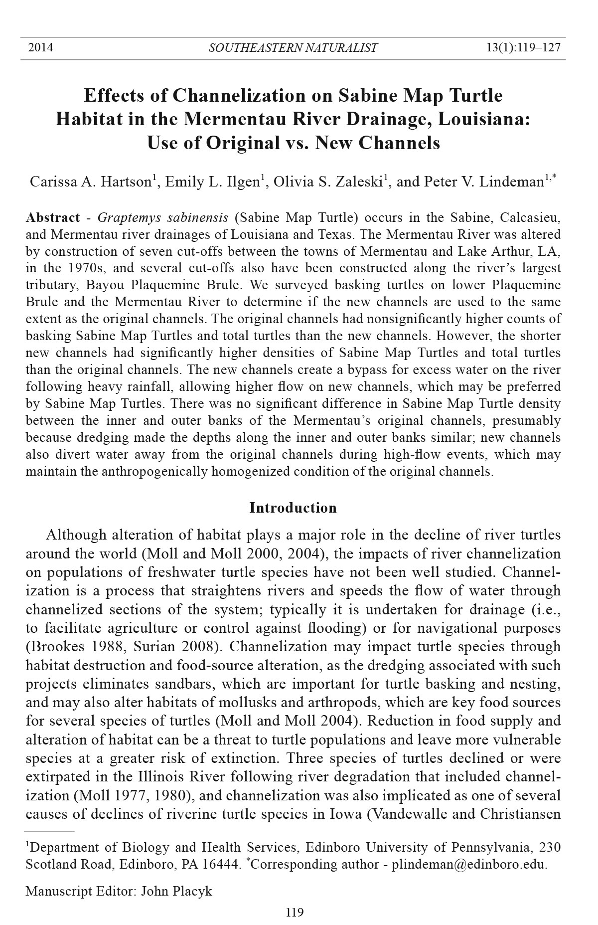
on the river’s largest tributary, Bayou Plaquemine Brule (Fig. 1). In addition, very
Figure 1. Map showing the location of the six cut-offs on the Mermentau River (A through
G, excluding D) and eight cut-offs on lower Bayou Plaquemine Brule (upper inset map,
H through O) that were surveyed for basking turtles. Lower inset map shows the regional
location in southwestern Louisiana.
Southeastern Naturalist
121
C.A. Hartson, E.L. Ilgen, O.S. Zaleski, and P.V. Lindeman
2014 Vol. 13, No. 1
few portions of the Mermentau drainage have not been dredged extensively (Vidrine
2010).
Cagle (1953) described Graptemys sabinensis Cagle (Sabine Map Turtle;
sensu Lindeman 2013), a narrow-headed species of Graptemys, based on an
extensive collection of specimens from the Sabine River in Sabine Parish, LA.
The species was first collected six decades earlier, however, from the Mermentau
River (Mermentau, Acadia Parish, LA) and a site presumably on the lower
Sabine River (Vinton, Calcasieu Parish, LA) (Cagle 1953; Ilgen et al., in press;
Lindeman 2013). No further specimens of Sabine Map Turtles were collected
from the Mermentau drainage between the 1890s and our studies, and several
recent sources have erroneously omitted the Mermentau drainage as part of the
species’ geographic range (Ilgen et al., in press; Lindeman 2013).
We conducted a survey of basking turtles, in particular Sabine Map Turtles, on
the Mermentau River and lower Bayou Plaquemine Brule to determine how construction
of cut-off channels has affected turtle species. We surveyed Sabine Map
Turtles and other basking turtles on 14 cut-offs, with pairwise comparison of basking
abundance and density on the original and new channels.
Study Area
Taxodium distichum L. (Baldcypress) and Nyssa aquatica L. (Water Tupelo)
are the dominant tree species along the banks of the Mermentau River. Houses,
shipyards, and other industry occur on a few portions of the old and new channels,
but most of the riparian forest is intact. The water is murky and sluggish, and
sandbars are lacking; thus, the drainage is atypical habitat for Graptemys species
in the southeastern United States (Lindeman 2013). Much of the character of our
study area on the Mermentau River and Bayou Plaquemine Brule derives from the
fact that the water level is less than 1 m above sea level throughout; thus, flow is often
negligible and can even move slowly in an upstream direction during periods of
heavy withdrawal for agriculture during droughts (Skrobialowski et al. 2004). At
the town of Mermentau (between the cut-offs of lower Plaquemine Brule and the
Mermentau), the river is ≈100 m wide and has a median discharge of 36 m3/s (mean
= 42 m3/s). At the time of our study, a sustained drought during the spring and summer
of 2011 caused flow to be nonexistent, with substantial saltwater encroachment
affecting lower sections of the drainage. Along the riverbanks, there were fallen
trees, often with emergent crowns, and other deadwood substrates which are used
by turtles for basking. The Mermentau channel is 80–180 m in width and has been
dredged to depths of 3–4 m, while lower Bayou Plaquemine Brule is 25–50 m wide
and is maintained to a depth of 2 m (Gammill et al. 2002).
The river engineering on the Mermentau has provided opportunities for habitat
expansion by Sabine Map Turtles and other freshwater turtle species. Some of the
original channels bypassed by cut-offs on upper sections of Bayou Plaquemine
Brule have begun to become filled in and closed off (P.V. Lindeman, 2010–2011
pers. observ.), conditions that do not favor persistence of Sabine Map Turtles
(Hively 2009). However, the original channels in our study area on the Mermentau
Southeastern Naturalist
C.A. Hartson, E.L. Ilgen, O.S. Zaleski, and P.V. Lindeman
2014 Vol. 13, No. 1
122
and lower Bayou Plaquemine Brule have remained wide and deep and may still
provide suitable habitat for Sabine Map Turtles.
Additional turtle species observed during the present study were Trachemys
scripta (Schoepff) (Pond Slider), Pseudemys concinna (Le Conte) (River Cooter),
Chrysemys picta (Schneider) (Painted Turtle), Sternotherus carinatus (Gray)
(Razor-backed Musk Turtle), and Apalone spinifera (LeSueur) (Spiny Softshell
Turtle). Graptemys pseudogeographica (Gray) (False Map Turtle), Sternotherus
odoratus (Latreille) (Eastern Musk Turtle), and Chelydra serpentina (L.) (Snapping
Turtle) also occur in the Mermentau drainage (Ilgen et al., in press) but were not
observed during our surveys of cut-offs and original channels.
Methods
Turtle surveys
We surveyed basking turtles on six of the seven cut-offs on the Mermentau (D
was not surveyed due to logistical concerns) and the eight lowest cut-offs on Bayou
Plaquemine Brule in May 2011 (Fig. 1), with one additional survey of cut-off A
from May 2010 included in the data set. We conducted all surveys on sunny warm
days between 0900 and 1700 hr. and used a jonboat with a 40-hp outboard motor to
conduct basking counts. One person steered the boat within 12–18 m of the bank,
while two spotters used 20x Bushnell binoculars and one used 18x Canon binoculars
with an image stabilizer. We sighted turtles on deadwood, fallen or bent-over
trees that retained foliage, stumps, riprap, and cypress knees, as well as occasionally
swimming in the water. We used head and shell patterns and shape to identify
turtles, and we kept the jonboat at a low speed to facilitate identification. We also
recorded turtles that jumped before identification or were partially hidden from
view, classifying them as unidentified.
Bayou Plaquemine Brule is narrow enough that we could survey the banks on
both sides with one pass down the center of the channel. For the wider Mermentau,
we made two passes in each channel, along mainland and island banks. We
surveyed most cut-offs more than once and averaged data from multiple surveys.
On the Mermentau, we surveyed cut-offs A and G each four times, F three times,
B twice, and C and E each once; we conducted no surveys on cut-off D. On Bayou
Plaquemine Brule, we surveyed cut-offs H–J each three times and K–O each twice.
In an attempt to remove possible bias resulting from turtles in one channel being
startled into the water during our survey of the other channel, we systematically
alternated whether we surveyed the new channel or original channel first for cutoffs
surveyed multiple times as well as whether we surveyed the mainland or island
banks first for Mermentau cut-offs. For the same reason, we systematically alternated
surveying a series of original channels on Bayou Plaquemine Brule in one
pass and then their corresponding new channels on a return pass and vice versa.
Channel measurement and turtle densities
We measured to the nearest 0.01 km the total length of each old and new channel
along its midstream using Google Earth’s satellite map imagery (2011). We used the
Southeastern Naturalist
123
C.A. Hartson, E.L. Ilgen, O.S. Zaleski, and P.V. Lindeman
2014 Vol. 13, No. 1
total distance surveyed to calculate turtles seen per kilometer. For the Mermentau,
we measured each of six original channels along their outer (mainland) and inner
(island) banks and calculated basking densities along each bank for comparison.
Because some turtles jumped into the water prior to being identified or were too
hidden from view to identify, we estimated the proportion of unidentified turtles
that were Sabine Map Turtles using a broader data set on relative abundance (Ilgen
et al., in press). We calculated total abundance of Sabine Map Turtles by first using
the percentages of all identified turtles that were Sabine Map Turtles in the broader
Mermentau and Plaquemine Brule surveys (90% and 86%, respectively; Ilgen et al.,
in press) to estimate the number of Sabine Map Turtles comprising the unidentified
category, and then combining confirmed and assumed Sabine Map Turtles. Total
turtles included all species observed, including unidentified turtles. We calculated
basking densities of confirmed and total Sabine Map Turtles and of all turtles by
dividing basking abundance numbers by distances surveyed.
Statistical analyses
We used S-PLUS to make statistical comparisons of both absolute numbers of
turtles seen and turtle densities as paired by each set of an original and a new channel.
Due to the paired nature of the data, any potential effects of weather condition,
time of day, date, and other factors on turtle basking abundance were nullified. We
used the Kolmogorov-Smirnov test to check data for normality (α = 0.05). If the
raw data were not normally distributed, we used natural-log transformations of
data to achieve normality. For normally distributed data, we used F-tests to confirm
equality of variance and then used a paired t-test to test for significant differences
in numbers or densities of turtles between original and new channels. For data that
could not be transformed to normality, we substituted the Wilcoxon signed-rank
test using raw data. We used the same protocol to test for significant differences in
Sabine Map Turtle numbers between paired island banks (inner bends) and mainland
banks (outer bends) of the original channels on the Mermentau River.
Results
For all surveys combined, we recorded 656 turtles on original channels (86%
identified to species) and 251 turtles on new channels (87% identified to species).
The number of confirmed Sabine Map Turtles averaged 12.9 on original and 7.3 on
new channels (Table 1). Estimated total average numbers of basking Sabine Map
Turtles were 15.0 on original and 8.1 on new channels. The total of all species
averaged 17.0 turtles on original and 8.9 turtles on new channels. Despite the fact
that in all cases means were greater on original than on new channels, there were
no statistically significant differences in paired comparisons of the number of confirmed
Sabine Map Turtles, total Sabine Map Turtles, or total turtles (Table 1).
A contrasting result was found when numbers of turtles were converted to densities,
due to the much greater lengths of the original channels (Fig. 1, Table 2).
There were significantly greater densities of confirmed Sabine Map Turtles, total
Sabine Map Turtles, and total turtles on new than on original channels (Table 1).
Southeastern Naturalist
C.A. Hartson, E.L. Ilgen, O.S. Zaleski, and P.V. Lindeman
2014 Vol. 13, No. 1
124
For the original channels of the Mermentau, there was no significant difference in
the density of confirmed Sabine Map Turtles between island and mainland banks
(t = 2.04, df = 5, P = 0.097; Fig. 2).
Discussion
While the higher numbers of basking Sabine Map Turtles and total turtles on the
original river channels relative to new cut-off channels on the Mermentau and Bayou
Table 1. Statistical comparisons of absolute numbers of turtles and densities. “Confirmed Sabine
Map Turtles” are the total number positively identified to species, while “Total Sabine Map Turtles”
combines confirmed Sabine Map Turtles with 90% of unidentified turtles seen in Mermentau surveys
and 86% of unidentified turtles seen in Plaquemine Brule surveys (see text). Densities were found by
dividing the raw data by the kilometers of river channel surveyed.
Original channel New channel Test
(mean ± SE) (mean ± SE) DataA StatisticB P
Total confirmed Sabine Map Turtles 12.91 ± 4.18 7.32 ± 1.70 raw Z = 1.35 0.1800
Total Sabine Map Turtles 14.98 ± 4.94 8.12 ± 1.75 ln t = 1.68 0.1200
Total turtles (all species) 16.97 ± 5.42 8.86 ± 1.69 ln t = 1.85 0.0880
Confirmed Sabine Map Turtles/km 16.19 ± 2.04 33.84 ± 5.87 ln t = −3.21 0.0068*
Total Sabine Map Turtles/km 18.74 ± 2.39 39.05 ± 6.34 ln t = −3.38 0.0050*
Total turtles/km 21.45 ± 2.76 44.26 ± 6.53 raw Z = −2.73 0.0040*
*Significant difference (α = 0.05).
ARaw values or natural-log transformations used to achieve normality.
BPaired t-test or Wilcoxon signed rank test (Z) used to test for significant dif ferences.
Figure 2. Mean Sabine Map Turtle densities on original channels of cut-offs of the Mermentau
River, separated according to bank on which they were seen. Tic marks show standard
errors on the means of the six cut-offs.
Southeastern Naturalist
125
C.A. Hartson, E.L. Ilgen, O.S. Zaleski, and P.V. Lindeman
2014 Vol. 13, No. 1
Plaquemine Brule did not achieve statistical significance, densities of basking turtles
were significantly higher on the new channels. Thus, creation of the cut-off channels
has created new and apparently more favorable habitat for the Sabine Map Turtle,
even as the original channels maintain their status as suitable habitat for substantial
populations, which are still high in number if not in density. A possible explanation
for the higher densities on new channels is that they may be more lotic in character
during high-flow events following rainfall (Brookes 1988, Surian 2008) and carry
more nutrients, which may favor the prey base of the Sabine Map Turtle, including
caddisfly larvae and other members of algal aufwuchs communities associated with
deadwood (Hively 2009, Shively and Jackson 1985). While a period of high flow
driven by groundwater might prompt higher basking frequency in cooler new channels
than in warmer original channels, the severe drought that took place in 2011
makes this an unlikely explanation for our results.
Table 2. Cut-off distances and widths for original and new channels on the Mermentau River (A
through G) and Bayou Plaquemine Brule (H through O), the number of surveys conducted on each
cut-off, and mean densities of Sabine Map Turtles (including 90% of unidentified turtles seen in
Mermentau surveys and 86% of unidentified turtles seen in Plaquemine Brule surveys; see text) and
total turtles.
Mean
Number Sabine Map Mean
Cut-off Channel Distance (km) Width (km) of surveys Turtles/km turtles/km
A Original 1.13 0.12 3 7.65 10.91
New 0.22 0.07 3 14.45 18.18
B Original 0.58 0.11 2 17.24 22.41
New 0.25 0.07 2 14.00 14.00
C Original 0.96 0.09 1 26.98 29.17
New 0.34 0.07 1 55.88 55.88
E Original 0.60 0.11 1 35.83 38.33
New 0.30 0.07 1 79.33 80.00
F Original 1.08 0.10 3 23.86 26.85
New 0.34 0.07 3 12.44 14.71
G Original 2.19 0.09 4 33.29 36.87
New 0.45 0.07 4 30.11 32.22
H Original 0.26 0.10 3 20.88 21.81
New 0.07 0.06 3 31.29 52.43
I Original 0.44 0.04 3 12.45 15.91
New 0.13 0.04 3 30.38 30.77
J Original 0.17 0.02 3 23.24 25.47
New 0.09 0.04 3 62.56 70.33
K Original 0.38 0.03 2 12.97 15.79
New 0.16 0.05 2 21.88 37.50
L Original 0.27 0.03 2 7.41 12.96
New 0.12 0.04 2 75.00 79.17
M Original 0.91 0.03 2 11.63 12.09
New 0.34 0.03 2 27.74 29.41
N Original 0.32 0.03 2 13.84 14.06
New 0.13 0.04 2 67.08 76.92
O Original 0.54 0.03 2 15.09 17.59
New 0.16 0.04 2 24.56 28.13
Southeastern Naturalist
C.A. Hartson, E.L. Ilgen, O.S. Zaleski, and P.V. Lindeman
2014 Vol. 13, No. 1
126
On a sandbar-dominated stretch of river—regarded as typical Graptemys habitat
in a Gulf Coastal drainage—one would expect outer bends of a river channel
to be deeper with faster current and thus have more deadwood and higher basking
densities (Lindeman 1999, 2013). We found no significant difference in Sabine
Map Turtle density along the mainland versus the island banks of the six Mermentau
cut-offs we surveyed; in fact, while the data approached significance despite
low statistical power (only six cut-offs were used in the analysis), higher averages
were on the inner, island banks, rather than on the outer, mainland banks. Dredging
of the river channel likely made the depths of the channels relatively uniform;
in addition, the low gradient of the Mermentau drainage causes flow to be virtually
nonexistent except after heavy rains, thus causing little in the way of bank
erosion and sediment deposition.
Moll and Moll (2004) suggested that channelization and its associated dredging
produce negative impacts for turtles by lowering the water table and speeding
run-off of water, thus eliminating backwater habitats. In the Mermentau drainage,
the primary floodplain backwater habitats would be ponds (platins) and
marshes (marais) that have been virtually eliminated in the drainage by agricultural
conversion to rice fields and crawfish ponds (Vidrine 2010, Vidrine et al.
2004). While the platins and marais would almost surely have provided additional
habitat to several other turtle species (some of which utilize the many crawfish
ponds that have replaced them; P.V. Lindeman, 2011 pers. observ.), whether or
not these shallow wetlands were ever highly utilized by more river-restricted species
like Sabine Map Turtles is uncertain. Our results show that new channels dug
to straighten the Mermentau River and lower Bayou Plaquemine Brule, together
with dredging that has maintained the connections to original channels, has increased
riverine habitat for Sabine Map Turtles and other turtle species of the
drainage and may help to maintain larger populations than would be present in the
river without the cut-offs.
Acknowledgments
We thank W. Selman and the Rockefeller Wildlife Refuge of Louisiana for use of their
jonboat. W. Selman and S. Shively read an earlier draft of the manuscript and made several
helpful comments. A Pennsylvania State System of Higher Education Faculty Professional
Development Grant funded our fieldwork in 2011.
Literature Cited
Brookes, A. 1988. Channelized Rivers: Perspectives for Environmental Management. John
Wiley and Sons, Chichester, UK. 326 pp.
Cagle, F.R. 1953. Two new subspecies of Graptemys pseudogeographica. Occasional Papers
of the Museum of Zoology of the University of Michigan 546:1–17.
Ewert, M.A., and D.R. Jackson. 1994. Nesting ecology of the Alligator Snapping Turtle,
Macroclemys temminckii, along the lower Apalachicola River, Florida. Unpublished
report to the Nongame Wildlife Program, Florida Game and Fresh Water Fish Commission,
Tallahassee, FL. 45 pp.
Southeastern Naturalist
127
C.A. Hartson, E.L. Ilgen, O.S. Zaleski, and P.V. Lindeman
2014 Vol. 13, No. 1
Gammill, S., K. Balkum, K. Duffy, E. Meselhe, J. Porthouse, E. Ramsey, and R. Walters.
2002. Hydrologic investigation of the Louisiana Chenier Plain. Unpublished report to
the Louisiana Coastal Wetlands Conservation and Restoration Task Force, Baton Rouge,
LA. 44 pp.
Hively, C.L. 2009. A comparative analysis of two turtle assemblages in an altered floodplain.
Unpublished M.Sc. Thesis. University of Texas at Tyler, Tyler, TX. 116 pp.
Ilgen, E.L., C.A. Hartson, O.S. Zaleski, and P.V. Lindeman. In press. Map turtles of the
Mermentau: Status surveys of forgotten populations. Chelonian Conservation and Biology.
Lindeman, P.V. 1999. Surveys of basking map turtles, Graptemys spp., in three river drainages
and the importance of deadwood abundance. Biological Conse rvation 88:33−42.
Lindeman, P.V. 2013. The Map Turtle and Sawback Atlas: Ecology, Evolution, Distribution,
and Conservation. University of Oklahoma Press, Norman, OK.
Moll, D.L. 1977. Ecological investigations of turtles in a polluted ecosystem: The central
Illinois River and adjacent flood plain lakes. Unpublished Ph.D. Dissertation. Illinois
State University, Normal, IL. 179 pp.
Moll, D. 1980. Dirty river turtles. Natural History 89(5):42–49.
Moll, D., and E.O. Moll. 2004. The Ecology, Exploitation, and Conservation of River
Turtles. Oxford University Press, New York, NY. 393 pp.
Moll, E.O., and D. Moll. 2000. Conservation of river turtles. Pp. 126–155, In M.W. Klemens
(Ed.). Turtle Conservation. Smithsonian Institution Press, Washington, DC. 344
pp.
Shively, S.H., and J.F. Jackson. 1985. Factors limiting the upstream distribution of the Sabine
Map Turtle. American Midland Naturalist 114:292–303.
Skrobialowski, S.C., S.V. Mize, and D.K. Demcheck. 2004. Environmental setting, water
quality, and ecological indicators of surface-water quality in the Mermentau River basin,
southwestern Louisiana, 1998–2001. Water-Resources Investigations Report 03-4185.
US Geological Survey, Baton Rouge, LA.
Surian, N. 2008. River channelization. Pp. 986–990, In S.W. Trimble (Ed.). Encyclopedia
of Water Science. Vol. II. CRC Press, Boca Raton, FL. 1586 pp.
Vandewalle, T.J., and J.L. Christiansen. 1996. A relationship between river modification
and species richness of freshwater turtles in Iowa. Journal of the Iowa Academy of Science
103:1–8.
Vidrine, M.F. 2010. The Cajun Prairie: A Natural History. Gail Q. Vidrine Collectables,
Eunice, LA. 314 pp.
Vidrine, M.F., G.J. Quillman-Vidrine, M.F. Vidrine II, D.J. Vidrine, and C.E. Vidrine. 2004.
Freshwater mussels (Bivalvia: Unionidae) in the Cajun prairie ecosystem in southwestern
Louisiana. Proceedings of the 19th North American Prairie Conferences 19:133–136.


 The Southeastern Naturalist is a peer-reviewed journal that covers all aspects of natural history within the southeastern United States. We welcome research articles, summary review papers, and observational notes.