Assessment of Bird Response to the Migratory Bird Habitat
Initiative Using Weather-Surveillance Radar
Mason L. Sieges, Jaclyn A. Smolinsky, Michael J. Baldwin, Wylie C. Barrow, Jr., Lori A. Randall, and Jeffrey J. Buler
Southeastern Naturalist, Volume 13, Issue 1 (2014): G36–G65
Full-text pdf (Accessible only to subscribers.To subscribe click here.)
Southeastern Naturalist
M.L. Sieges, J.A. Smolinsky, M.J. Baldwin, W.C. Barrow, Jr., L.A. Randall, and J.J. Buler
2014 Vol. 13, No. 1
G36
2014
Assessment of Bird Response to the Migratory Bird Habitat
Initiative Using Weather-Surveillance Radar
Mason L. Sieges1, Jaclyn A. Smolinsky1, Michael J. Baldwin2,
Wylie C. Barrow, Jr.2, Lori A. Randall2, and Jeffrey J. Buler1,*
Abstract - In response to the Deepwater Horizon oil spill in spring 2010, the Natural Resources
Conservation Service implemented the Migratory Bird Habitat Initiative (MBHI) to
provide temporary wetland habitat for migrating and wintering waterfowl, shorebirds, and
other birds along the northern Gulf of Mexico via managed flooding of agricultural lands.
We used weather-surveillance radar to conduct broad regional assessments of bird response
to MBHI activities within the Mississippi Alluvial Valley and the West Gulf Coastal Plain.
Across both regions, birds responded positively to MBHI management by exhibiting greater
relative bird densities within sites relative to pre-management conditions in prior years and
relative to surrounding non-flooded agricultural lands. Bird density at MBHI sites was generally
greatest during winter for both regions. Unusually high flooding in the years prior to
implementation of the MBHI confounded detection of overall changes in remotely sensed soil
wetness across sites. The magnitude of bird response at MBHI sites compared to prior years
and to non-flooded agricultural lands was generally related to the surrounding landscape context:
proximity to areas of high bird density, amount of forested wetlands, emergent marsh,
non-flooded agriculture, or permanent open water. However, these relationships varied in
strength and direction between regions and seasons, a finding which we attribute to differences
in seasonal bird composition and broad regional differences in landscape configuration and
composition. We detected greater increases in relative bird use at sites in closer proximity to
areas of high bird density during winter in both regions. Additionally, bird density was greater
during winter at sites with more emergent marsh in the surrounding landscape. Thus, bird use
of managed wetlands could be maximized by enrolling lands located near areas of known bird
concentration and within a mosaic of existing wetlands. Weather-radar observations provide
strong evidence that MBHI sites located inland from coastal wetlands impacted by the oil spill
provided wetland habitat used by a variety of birds.
Introduction
The northern Gulf Coast is home to diverse wetlands arrayed along 75,000 km
of shoreline that include habitat for a wide variety of resident and migratory waterbirds
(Helmers 1992, Mikuska et al. 1998, Musumeche et al. 2002). These wetlands
have been significantly degraded by human-induced landscape alterations (Britsch
and Dunbar 1993, Ellis and Dean 2012, Nestlerode et al. 2009), sea-level rise associated
with climate change (Hoozemans et al. 1993), powerful storms (Barras 2006,
Lopez 2009), and the Deepwater Horizon oil spill in April 2010, the largest spill to
date off the Gulf Coast (Copeland 2010).
SOUTHEASTERN NATURALIST
Gulf of Mexico Natural History and Oil Spill Impacts Special Series
1Department of Entomology and Wildlife Ecology, University of Delaware, 531 South College
Avenue, Newark, DE 19716. 2US Geological Survey, National Wetlands Research Center, 700
Cajundome Boulevard, Lafayette, LA 70506. *Corresponding author - jbuler@udel.edu.
Manuscript Editor: Frank R. Moore
13(1):G36–G65
Southeastern Naturalist
G37
M.L. Sieges, J.A. Smolinsky, M.J. Baldwin, W.C. Barrow, Jr., L.A. Randall, and J.J. Buler
2014 Vol. 13, No. 1
In response to this event, the Natural Resources Conservation Service (NRCS)
implemented the Migratory Bird Habitat Initiative (MBHI) to provide migrating
and wintering waterfowl, shorebirds, and other birds with alternative habitats to
compensate for loss of coastal wetlands impacted by the oil spill. Wetland habitat
was created through the MBHI program by paying private landowners to flood existing
farmed wetlands, previously converted croplands, and other lands that had
not been actively flooded during the winter months for the previous three years. Numerous
bird species use flooded agricultural lands and adjacent areas for daytime
roosting and foraging along the Gulf Coast (Floyd 2000, Huner 1995, Musumeche
et al. 2002, Remsen et al. 1991). The NRCS identified the Mississippi Alluvial
Valley (MAV) and West Gulf Coastal Plain (WGCP) ecoregions as program priority
areas because of their adjacency to oil-spill–impacted-wetlands. In the fall of
2010, MBHI activities commenced on private agricultural or other lands already
enrolled in existing Farm Bill Programs: Wetlands Reserve Program (WRP), Environmental
Quality Incentives Program (EQIP), and Wildlife Habitat Incentive
Program (WHIP). Program activities continued through the winter for all MAV
sites and through the spring of 2011 (or longer for some sites in Louisiana with
multi-year contracts) for sites within the WGCP. Approximately 188,375 hectares
were enrolled into the MBHI within the MAV and WGCP across five states (Texas,
Louisiana, Arkansas, Missouri, and Missippi; USDA NRCS 2012).
Water levels at MBHI sites were managed for shallow water, mudflat, and sandflat
habitats to create or enhance habitat for shorebirds and waterfowl. According to
the NRCS practice standard for shallow water development and management (code
646; USDA NRCS 2010), flooding 0–10 cm (0–4 in ) from July to October provides
habitat for shorebirds, and water depths 15–20 cm (6–10 in ) from October to March
benefit waterfowl. Although water management protocols at sites within each state
were intended to be identical, variability in actual water management, site characteristics
and location, and features of the surrounding landscape may have resulted
in differential bird use among sites. For example, in the Central Valley of California,
wintering waterfowl use of managed wetlands is greater at sites with greater soil
wetness (i.e., extent of managed flooding), with fewer wetlands in the surrounding
landscape, and with greater proximity to flooded rice fields where waterfowl typically
forage at night (Buler et al. 2012a). The amount and type of agricultural fields
in the surrounding landscape may attract some species while deterring others that
are more sensitive to human disturbance and development (Czech and Parsons 2002,
Niemuth et al. 2006). The amount of open water near managed lands (Fairbairn and
Dinsmore 2001, Manley et al. 2005) may also play a role in how birds use wetlands
for roosting and feeding. Waterfowl often react to avian and terrestrial predators by
moving to open water and grouping together in refugia (Tamisier 1976). Cox and
Afton (1997) found that female Anas acuta L. (Northern Pintail), regularly use pools
of open water on hunting refuges during the fall hunting season in southwestern
Louisiana. Based on refuging theory, MBHI sites located near refuges with high bird
concentrations may be used more heavily than sites far from refuges (Cox and Afton
1996, Link et al. 2011).
Southeastern Naturalist
M.L. Sieges, J.A. Smolinsky, M.J. Baldwin, W.C. Barrow, Jr., L.A. Randall, and J.J. Buler
2014 Vol. 13, No. 1
G38
Due to the rapid implementation of the MBHI program, there is little data regarding
bird use prior to management at most sites. This lack of baseline information
limits assessment of the program’s efficacy through traditional field-survey methods.
Additionally, a comprehensive assessment of bird response among the numerous
and widespread sites in both regions through traditional field surveys is not financially
or logistically feasible. Instead, remotely sensed weather-surveillance radar
observations of bird activity can provide a more comprehensive assessment of bird
use at numerous sites and, because they are archived, provide observations of bird use
prior to enrollment in the MBHI program. The current national network of weathersurveillance
radars (model WSR-88D, commonly referred to as NEXRAD) is an
important tool used to study a variety of bird movements across the United States
(Bonter et al. 2007; Diehl et al. 2003; Gauthreaux and Belser 1998, 2003; Kelly et al.
2012). NEXRAD can be used to measure bird densities and map their distributions on
the ground as birds take flight en masse from terrestrial habitats at the onset of highly
synchronized broad-scale movements, such as nocturnal feeding flights of wintering
waterfowl and migratory flights of land birds (Buler and Diehl 2009, Buler and Moore
2011, Buler et al. 2012a). Specifically, along the Gulf Coast during the winter, large
groups of waterfowl and other species regularly undertake flights between roosting
sites—usually wetlands and bodies of water—and feeding habitats such as agricultural
fields (Buler et al. 2012a, Paulus 1988, Randall et al. 2011). These highly-synchronized
movements tend to occur near sunrise and sunset and are closely related to
sun elevation (Baldassarre and Bolen 1984, Cox and Afton 1996, Ely 1992, Raveling
et al. 1972). Similarly, many birds, including waterfowl, shorebirds, and land birds,
initiate nocturnal migratory flights shortly after sunset (Akesson et al. 1996, Bonter et
al. 2009, Diehl et al. 2003, Gauthreaux and Belser 2003, Hebrard 1971).
Methods
Study area
MBHI sites were located within several states of the MAV (Missouri, Arkansas,
and Mississippi) and the WGCP (Louisiana and Texas) (Fig. 1). The predominant
agricultural land-uses are soybean and rice fields in the MAV and aquaculture (ricecultivation
and crawfish farming), pastures, hayfields, and idle/fallow cropland in
the WGCP region (USDA NASS CDL 2010). Rice farming is ideal for integrating
an established agricultural practice with the goal of waterbird conservation because
the water-control infrastructure necessary for farming can be used to manipulate
habitat to benefit waterbirds (Elphick 2000, Huner et al. 2002, Norling et al. 2012).
Six NEXRAD stations are located within the study area and potentially provide surveillance
of MBHI sites: Lake Charles, LA (KLCH); Houston, TX (KHGX); Little
Rock, AR (KLZK); Memphis, TN (KNQA); Paducah, KY (KPAH); and Ft. Polk,
LA (KPOE). We did not consider data from KPOE because it is not archived in its
native Level II format. We obtained information about MBHI tract boundaries and
management activities from state NRCS offices. We excluded from analysis individual
sites that were smaller than 0.5 ha in area. Only Arkansas sites were within
the effective radar detection range for radars within the MAV; therefore sites in
Mississippi and Missouri and all data from KPAH were excluded from analysis.
Southeastern Naturalist
G39
M.L. Sieges, J.A. Smolinsky, M.J. Baldwin, W.C. Barrow, Jr., L.A. Randall, and J.J. Buler
2014 Vol. 13, No. 1
MBHI sites were under varying degrees of active moist soil management,
depending on the timing and intensity of water-level manipulation. In Texas and
Arkansas, fields were flooded to a water depth of 5–46 cm (2–18 in). Based on the
timing of management in Texas and Arkansas, we defined our seasons for both regions
as fall (1 October–31 October), winter (1 November–28 February), and, for
Figure 1. Locations of MBHI sites (black dots) within the effective observation areas (dark
grey) of four weather surveillance radars (labeled by name) within the Mississippi Alluvial
Valley and West Gulf Coastal Plain regions of the southern US. The light grey area denotes
counties of states included in the MBHI program.
Southeastern Naturalist
M.L. Sieges, J.A. Smolinsky, M.J. Baldwin, W.C. Barrow, Jr., L.A. Randall, and J.J. Buler
2014 Vol. 13, No. 1
G40
WGCP only, spring (1 March–31 March). Louisiana offered a variety of habitats
that were managed to benefit different groups of waterbirds. The 4 management
settings used were: mudflats that were disked or rolled and flooded to a maximum
of 5 cm (2 in) to benefit early migrating waterfowl and shorebirds, food/cover
habitat where the vegetation was left standing and flooded to a depth of 15–25 cm
(6–10 in) to provide forage and sanctuary for wintering waterfowl, crawfish ponds
to provide invertebrate prey for waterbirds through the winter to mid-summer, and
an extension of either the mudflat or food/cover practice type. Additionally, Louisiana
altered the timing of management among these types. Therefore, we limited
analysis of Louisiana sites to those that most closely matched the timing and type
of management at Texas sites for the WGCP region. In fall, we only included Louisiana
sites with managed mudflats or active flooding associated with food/cover
habitat from 1 October to 31 October. In winter and spring, we only used Louisiana
sites with active flooding associated with food/cover habitat. Winter management
at Louisiana sites occurred during a narrower timeframe than at Texas sites (15
November to 30 January).
In the WGCP, we analyzed sites totaling 14,177 ha in the fall (7732 ha in TX and
6445 ha in LA), 12,141 ha in the winter (6039 ha in TX and 6102 ha in LA), and 6924
ha in the spring (6400 ha in TX and 524 ha in LA). In the MAV, we analyzed sites
totaling 2575 ha and 2519 ha for fall and winter, respectively. Variability in the area
analyzed is due to differences in the amount of area enrolled between seasons and differences
in the effective detection range of the radar among sampling days. Overall,
we sampled approximately 10% of the total area enrolled in MBHI within Arkansas
(MAV) and 15% of enrolled area in Texas and Louisiana (WGCP).
Weather-surveillance radar data
We obtained radar data collected during time periods associated with migrating
and wintering bird movements from 15 August through 31 May for the years 2008–
2011 at KLCH, KHGX, KZLK, and KNQA from the National Climatic Data Center
data archive (http://www.ncdc.noaa.gov/nexradinv/). Radars measure reflectivity
factor (Z) in the form of returned radiation (Crum and Alberty 1993) within sample
volumes having dimensions of 250 m long by 0.5º diameter. The density of birds on
the ground is positively correlated to radar reflectivity at the onset of flight exodus
(Buler and Diehl 2009, Buler et al. 2012a). We used radar data from nights with no
discernible influence from precipitation or ground returns from extreme radar-beam
refraction. Additionally, we excluded data from individual sample volumes subject
to persistent ground clutter and beam blockage. We flattened radar-sample volumes
into their two-dimensional polar boundaries (250 m deep and 0.5º wide) to produce
sample polygons for overlaying onto land-cover maps using GIS. These sample
polygons represent the elementary measurement resolution of radar reflectivity.
We interpolated reflectivity measures to an elevation angle of 5.5° below horizon
sensu Buler et al. (2012a), to reduce temporal sampling error and bias (Buler
and Diehl 2009). Buler et al. (2012a) found that this is the optimal sun angle for
quantifying ground densities of waterfowl, and it is temporally close to the onset
Southeastern Naturalist
G41
M.L. Sieges, J.A. Smolinsky, M.J. Baldwin, W.C. Barrow, Jr., L.A. Randall, and J.J. Buler
2014 Vol. 13, No. 1
of nocturnal feeding flights of wintering waterfowl (Baldassarre and Bolen 1984,
Cox and Afton 1996, Miller 1985, Randall et al. 2011, Tamisier 1976) and nocturnal
flights of migrating birds (Akesson et al. 1996, Gauthreaux 1971, Hebrard 1971). We
adjusted reflectivity measures to reduce range-dependent measurement bias caused
by the systematic change in how the vertical distribution of birds in the airspace is
sampled as the beam spreads with range from the radar using algorithms implemented
in the software program BIRDS as described and developed in Buler et al. (2012a).
Soil-wetness data
We used remotely sensed Landsat Thematic Mapper (TM) data to quantify the
extent of flooding during the MBHI management year and two previous years via a
soil-wetness index. The extent of actual flooding is often dependent on water supplies
and landowner compliance (Huner et al. 2002, L.A. Randall, pers. comm.). We
did not measure water depth at MBHI sites. Rather, we used TM , which can detect
soil moisture and the extent of the surface water remotely (Alsdorf et al. 2007,
Baker et al. 2007, Rodgers and Smith 1997). We screened and downloaded all available
TM data to obtain as many cloud-free images per season as possible from the
USGS (http://glovis.usgs.gov/). We calculated the mean soil-wetness index via the
tasseled cap transformation of Huang et al. (2002) for TM 7 data and Crist (1985)
for TM 5 data. TM data have a spatial resolution of 30 m x 30 m. Increasing values
indicate increasing soil wetness. Based on confirmation with visual inspection of
imagery, we defined open surface-water condition (flooded soil) as areas with index
values greater than -0.05 (Fig. 2). We used this threshold to determine the extent
of flooding within MBHI-enrolled areas. We also determined the change in soil
wetness from baseline years (2008–2009 and 2009–2010) to the management year
(2010–2011) in fall and winter. During the spring of 2011, all TM images in the
KHGX and KLCH radar ranges were obscured by clouds; therefore, we could not
compare site soil-wetness during spring management to the baseline years.
Landscape composition and position data
We quantified the amount of four land-cover types surrounding individual radar
sample polygons as measures of landscape composition. We calculated the percent
cover of agricultural land, emergent marsh, permanent open water, and forested
wetlands in the surrounding landscape at multiple scales using the 30-m resolution
2006 National Land-cover Database produced by the USGS Multi-Resolution Land
Characteristics Consortium (http://www.mrlc.gov/). We determined the percentage
of flooded vs. non-flooded agricultural land using the soil-wetness index derived
from TM imagery. We classified agricultural fields with a maximum seasonal
wetness-index value less than -0.05 as non-flooded, and fields with values greater
than -0.05 as flooded. We determined a single-characteristic scale at which birds
responded most strongly (i.e., strongest correlation) to each land-cover type in the
landscape (sensu Holland et al. 2004) by assessing the correlations between mean
radar reflectivity of MBHI site polygons and the proportion of land cover surrounding
polygons among landscapes within a 500-m–4500-m radius at intervals of
500 m. We analyzed data from each radar site separately by season. We randomly
Southeastern Naturalist
M.L. Sieges, J.A. Smolinsky, M.J. Baldwin, W.C. Barrow, Jr., L.A. Randall, and J.J. Buler
2014 Vol. 13, No. 1
G42
selected 25 samples of 20 polygons separated by at least 4 km for testing. We averaged
Spearman rank correlation coefficients among the set of samples to assess
correlations. We did not assess correlations for KNQA because of the scarcity of
MBHI-enrolled areas. We used the single-characteristic scale for each land-cover
type by season and radar site for further analyses.
We calculated the mean distance of each sample polygon to the nearest polygon
having a seasonal mean reflectivity during baseline years above the 90th percentile
as a measure of its relationship within the landscape to an area of high bird density.
We used the area-weighted mean reflectivity of all sample polygons to determine
Figure 2. Mean soil-wetness index data for 12 MBHI sites (black outlines) located in Texas
derived from TM data. Three TM images show temporal variation in wetness data. Sites
are completely flooded in the October 2010 image in accordance w ith MBHI management.
Corresponding mean wetness-index values are plotted for the entire study period illustrating
the fall–winter–spring flooding regime on the 12 MBHI sites. Shaded bars distinguish the
periods of active management.
Southeastern Naturalist
G43
M.L. Sieges, J.A. Smolinsky, M.J. Baldwin, W.C. Barrow, Jr., L.A. Randall, and J.J. Buler
2014 Vol. 13, No. 1
the value of the 90th percentile of reflectivity by radar and season. This approach
effectively identified areas with the highest bird density (top decile) that occurred
within each radar-observed area. Some of the identified sites were previously
documented bird concentration areas, such as Lacassine National Wildlife Refuge
(NWR) and Cameron Prairie NWR in Louisiana (Link et al. 2011), where wintering
waterfowl congregate.
Data analyses
We standardized reflectivity measures in order to control for annual fluctuations in
overall bird populations that could influence absolute reflectivity measures. Because
we were also interested in comparing relative bird density on managed agricultural
lands (flooded) to unmanaged agricultural lands (unflooded), we standardized reflectivity
values by dividing the seasonal mean reflectivity of a given sample polygon by
the area-weighted seasonal mean reflectivity of all radar-sample polygons dominated
(>75% of area) by non-flooded agricultural lands for each radar, season, and year
combination. We excluded non-flooded agricultural areas ≤1 km from flooded agriculture
to minimize potential contamination from birds using nearby flooded fields
at the time of sampling. Thus, a standardized reflectivity value of 1 equals the mean
relative bird density of non-flooded agricultural fields for a given season, year, and
region. For spring 2011, when images were unusable due to cloud contamination,
we standardized reflectivity values by dividing the mean reflectivity within a given
sample polygon by the area-weighted seasonal mean reflectivity of all radar-sample
polygons dominated (>75% of area) by agriculture. For MBHI-managed areas, we
calculated the area-weighted mean standardized reflectivity of the portion of sample
polygons within site boundaries. We used this standardized reflectivity as an indicator
of bird response to MBHI management and the response variable for modeling
bird use of MBHI areas within the management year.
We also examined bird response to MBHI activities by comparing bird density
in the two years prior to management (2008 and 2009) to bird density during the
active management year (2010). To do this, we divided the standardized reflectivity
at MBHI areas during the management year by the standardized reflectivity at
areas across the prior years by season and region. We used this ratio as a second
indicator of bird response to MBHI management and the response variable for modeling
bird use of MBHI areas between years. A ratio value greater than 1 indicated
that bird density was greater during the management year. Additionally, using this
ratio helped to control for perennial contamination in the airspace from birds taking
flight from the surrounding landscape (Buler et al. 2012b). To understand how
management practices influenced our total assessed area, we also calculated the
proportion of MBHI areas that showed increases in mean wetness, mean reflectivity
during the management year, and mean reflectivity relative to prior years.
Modeling bird response
We used linear regression modeling with an information-theoretic approach to
determine the relative importance of variables in explaining variation in reflectivity
among areas (Burnham and Anderson 2002). To minimize spatial autocorrelation
Southeastern Naturalist
M.L. Sieges, J.A. Smolinsky, M.J. Baldwin, W.C. Barrow, Jr., L.A. Randall, and J.J. Buler
2014 Vol. 13, No. 1
G44
while maintaining adequate sample sizes, we sampled 25 subsets of 20 radarsample
volumes spaced at least 4 km apart. We averaged results across sample runs
when assessing models. However, as reported earlier, we were unable to model bird
response for the KNQA radar. We also did not model bird response during spring
for the WGCP because we had no suitable TM imagery to determine soil wetness.
We modeled two response variables: standard reflectivity during the management
year and the ratio of reflectivity relative to prior years. Explanatory variables included
a single soil-wetness variable (either soil wetness during the management
year or the change in site wetness from prior years) and several landscape variables:
1) proximity to high bird-density area; 2) amount of forested wetlands in the surrounding
landscape; 3) amount of non-flooded agricultural fields in the surrounding
landscape; 4) amount of permanent open water in the surrounding landscape;
and 5) for WCGP radars, amount of emergent marsh in the surrounding landscape
(Table 1). We considered all possible combinations of models with main effects: 63
for WGCP radars and 31 for KLZK. We did not include amount of emergent marsh
in the landscape as a covariate for the KLZK because it was ≤1% of the landscape.
Data were log-transformed when necessary to improve normalcy of their distributions.
We used Akaike’s information criterion, adjusted for small sample sizes, and
Akaike weights to determine support for models (Burnham and Anderson 2002).
After summing the weights across all models to estimate the relative importance of
the variables of interest, we calculated the mean standardized regression coefficient
for all models to determine the direction and importance of effect sizes. We estimated
precision using an unconditional variance estimator that incorporated model
selection uncertainty (Burnham and Anderson 2002) and considered the effect of
Table 1. Summary statistics of landscape variables used for modeling bird response among Migratory
Bird Habitat Initiative sites by radar and season. Sample sizes reported in Table 3.
KLCH KHGX KLZK
Variable Mean (range) Mean (range) Mean (range)
Fall
Proportion of cover type within a 4.5-km radius
Permanent open water 0.02 (0.00–0.23) 0.03 (0.00–0.48) 0.05 (0.01–0.16)
Forested wetland 0.06 (0.00–0.47) 0.04 (0.00–0.24) 0.15 (0.01–0.35)
Non-flooded agriculture 0.59 (0.05–0.90) 0.22 (0.00–0.50) 0.65 (0.29–0.94)
Emergent marsh 0.08 (0.00–0.53) 0.17 (0.00–0.84) 0.00 (0.00–0.01)
Proximity to high bird-density 2.61 (0.00–26.20) 7.38 (0.00–23.87) 2.42 (0.00–11.78)
area (km)
Winter
Proportion of cover type within a 4.5-km radius
Permanent open water 0.03 (0.00–0.24) 0.03 (0.00–0.48) 0.05 (0.01–0.16)
Forested wetland 0.06 (0.00–0.38) 0.04 (0.00–0.24) 0.15 (0.01–0.35)
Non-flooded agriculture 0.43 (0.05–0.70) 0.21 (0.00–0.47) 0.64 (0.28–0.94)
Emergent marsh 0.08 (0.00–0.50) 0.16 (0.00–0.84) 0.00 (0.00–0.01)
Proximity to high bird-density 1.25 (0.00–18.26) 14.67 (1.17–31.63) 8.20 (0.00–48.26)
area (km)
Southeastern Naturalist
G45
M.L. Sieges, J.A. Smolinsky, M.J. Baldwin, W.C. Barrow, Jr., L.A. Randall, and J.J. Buler
2014 Vol. 13, No. 1
an explanatory variable as strong if the 90% confidence interval of the regression
coefficient did not span zero.
Results
After including only potential days during active MBHI management seasons
and eliminating days with contaminated radar data, we sampled a total of 125 out of
546 days (23%) for KHGX and 97 out of 420 days (23%) for KLCH in the WGCP.
For the MAV, we sampled 113 out of 453 days (25%) for KLZK and 86 out of 453
days (19%) for KNQA. We determined soil-wetness index using an average of
2.8 TM images per season per radar during the management year and an average
of 6.4 TM images per season per radar during the prior two years, excluding the
spring (Table 2).
Daily mean radar reflectivity (i.e., relative bird density) varied considerably between
the radars throughout the management periods; the KLZK and KLCH radars
showed much higher reflectivity overall (Fig. 3). For all radars, reflectivity peaked
during winter management, although the timing differed among radars: peaks occurred
for KHGX in early winter peak, KLZK and KNQA in mid-winter, and KLCH
in late winter.
Overall, we found increases in bird density relative to prior years and relative
to non-flooded agriculture (NFA) in the management year for nearly all seasons
and radars (Table 3). This finding is indicated by values >1 for the mean standardized
reflectivity and the ratio of reflectivity relative to prior years. The exceptions
were at sites relative to NFA in the management year within the KNQA radar range
in fall (0.91) and the KHGX radar range in spring (0.24). The majority of MBHI
Table 2. Sample size (number of days) for determining mean reflectivity from NEXRAD data and
mean soil-wetness index from Thematic Mapper data by year, season, and radar.
Radar
Season Remote sensor KLCH KHGX KLZK KNQA
Management year (2010–2011)
Fall NEXRAD 9 12 5 8
Thematic Mapper 3 2 3 4
Winter NEXRAD 12 27 41 16
Thematic Mapper 1 4 2 3
Spring NEXRAD 7 10 n/a n/a
Thematic Mapper 0 0 n/a n/a
Prior years (2008–2010)
Fall NEXRAD 14 24 16 20
Thematic Mapper 2 2 3 3
Winter NEXRAD 51 41 51 41
Thematic Mapper 8 14 11 8
Spring NEXRAD 4 11 n/a n/a
Thematic Mapper 1 1 n/a n/a
Southeastern Naturalist
M.L. Sieges, J.A. Smolinsky, M.J. Baldwin, W.C. Barrow, Jr., L.A. Randall, and J.J. Buler
2014 Vol. 13, No. 1
G46
Figure 3. Daily mean
relative bird density during
the management year
at MBHI sites for each
radar site. Shaded bars
distinguish the periods of
active management.
Southeastern Naturalist
G47
M.L. Sieges, J.A. Smolinsky, M.J. Baldwin, W.C. Barrow, Jr., L.A. Randall, and J.J. Buler
2014 Vol. 13, No. 1
Table 3. Summary statistics for measures of soil wetness and relative bird density (i.e., standard reflectivity) during the year of active management and
compared to prior years without management. Statistics are divided among Migratory Bird Habitat Initiative sites in the West Gulf Coastal Plain and the
Mississippi Alluvial Valley by radar and season. Sample size is number of sample polygons assessed.
West Gulf Coastal Plain Mississippi Alluvial Valley
KLCH KHGX KLZK KNQA
Variable Mean (range) Mean (range) Mean (range) Mean (range)
Fall n = 2743 n = 1616 n = 534 n = 171
Soil-wetness index during management year -0.14 (-0.42–0.03) -0.13 (-0.55–0.04) -0.22 (-0.41– -0.04) -0.19 (-0.29–0.01)
Change in soil wetness index from prior years -0.02 (-0.29–0.27) -0.01 (-0.33–0.22) -0.09 (-0.21–0.09) -0.08 (-0.24–0.12)
Standard reflectivity during management year 2.33 (0.00–14.85) 2.60 (0.00–20.32) 2.66 (0.08–9.03) 0.91 (0.23–2.29)
Reflectivity relative to prior years 2.74 (0.02–96.24) 9.44 (0.03–209.83) 7.82 (0.20–75.50) 1.21 (0.38–2.85)
Winter n = 2921 n = 1531 n =5 34 n = 148
Soil-wetness index during management year -0.09 (-0.33–0.06) -0.07 (-0.18–0.03) -0.13 (-0.23–0.02) -0.05 (-0.13–0.02)
Change in soil wetness index from prior years 0.00 (-0.24–0.19) 0.01 (-0.13–0.16) -0.03 (-0.13–0.13) 0.03 (-0.03–0.10)
Standard reflectivity during management year 1703.38 (0.27–29211.01) 5.06 (0.13–112.62) 29.86 (0.00–415.51) 1.93 (0.10–44.90)
Reflectivity relative to prior years 10.27 (0.10–272.19) 5.71 (0.12–91.99) 1.64 (0.05–16.71) 2.80 (0.18–29.10)
Spring n = 206 n = 1603
Standard reflectivity during management year 2.45 (0.01–20.29) 0.24 (0.00–7.00) n/a n/a
Reflectivity relative to prior years 2.21 (0.01–9.61) 1.97 (0.01–35.51) n/a n/a
Southeastern Naturalist
M.L. Sieges, J.A. Smolinsky, M.J. Baldwin, W.C. Barrow, Jr., L.A. Randall, and J.J. Buler
2014 Vol. 13, No. 1
G48
area exhibited greater bird use relative to NFA within management year and relative
to prior years for fall (area-weighted mean across all radars of 65% and 74%,
respectively) and winter (area-weighted mean across all radars of 78% and 82%,
respectively) but not during spring (area-weighted mean across all radars of 6% and
42%, respectively) (Table 4). Exceptions for a majority increase in bird use relative
to NFA in the management year by radar included KNQA during the fall and KLCH
and KHGX in the spring. Additionally, a majority of the area (60%) around KHGX
during the spring did not increase in bird use relative to prior years.
The magnitude and extent of increases varied among seasons and radars such
that the greatest increases in the amount and extent of reflectivity relative to prior
years occurred during winter in Louisiana (KLCH) and easternmost Arkansas
(KNQA) sites and during fall in Texas (KHGX) and western Arkansas (KLZK)
sites (Table 3). The greatest use by birds of MBHI-managed sites relative to NFA
occurred during winter at all radars. The greatest responses to MBHI management
both within and between years, across all radars and seasons, occurred at Louisiana
sites during the winter. Here, over 90% of MBHI area had increased bird use
relative to previous years and NFA, such that the average bird density was over
10 times the levels recorded for previous years and over 1700 times levels at NFA
sites. Because of our sensitivity to the use of private landowner information, we
Table 4. Proportion of MBHI area that increased in soil wetness and bird use from prior years and
with greater bird use relative to non-flooded agriculture areas during the management year by season
and radar.
Radar
Season KLCH KHGX KLZK KNQA
Fall
Total hectares assessed 7613 6445 1964 611
Proportion w/ increased mean soil wetness 0.44 0.43 0.06 0.10
from prior years
Proportion w/ mean standardized reflectivity 0.63 0.65 0.81 0.31
greater than 1 during management year
Proportion w/ increased mean relative reflectivity 0.65 0.82 0.86 0.62
from prior years
Winter
Total hectares assessed 5884 6102 1964 555
Proportion w/ increased mean soil wetness 0.52 0.54 0.22 0.92
from prior years
Proportion w/ mean standardized reflectivity 0.96 0.64 0.73 0.50
greater than 1 during management year
Proportion w/ increased relative reflectivity 0.91 0.86 0.46 0.78
from prior years
Spring
Total hectares assessed 512 6400 n/a n/a
Proportion w/ mean standardized reflectivity 0.35 0.04 n/a n/a
greater than 1 during management year
Proportion w/ increased relative reflectivity 0.63 0.40 n/a n/a
from prior years
Southeastern Naturalist
G49
M.L. Sieges, J.A. Smolinsky, M.J. Baldwin, W.C. Barrow, Jr., L.A. Randall, and J.J. Buler
2014 Vol. 13, No. 1
do not present maps of these results with individual MBHI areas identified. Rather
we provide data from an example MBHI area to illustrate the strong bird response
during winter at a Louisiana location (Fig. 4). The weakest bird response to MBHI
management overall occurred during the spring in Texas.
Mean soil-wetness index during the management year nearly always indicated
average non-flooded soil conditions at sites during fall and winter (Table 3). However,
there were usually areas that were flooded within MBHI site boundaries even
if the entire site was not flooded (see Fig. 4). The change in mean fall soil-wetness
index from prior years was always negative, indicating drier soil in the management
year. However, it was slightly positive for the KHGX and KNQA radars in
winter. Soil wetness was greatest during winter, though only slightly more than
half of the MBHI area in the WGCP was considered flooded. During winter in the
MAV, nearly all of the MBHI area was flooded at KNQA, but less than a quarter
was flooded at KLZK. The lower soil wetness during fall is consistent with the fall
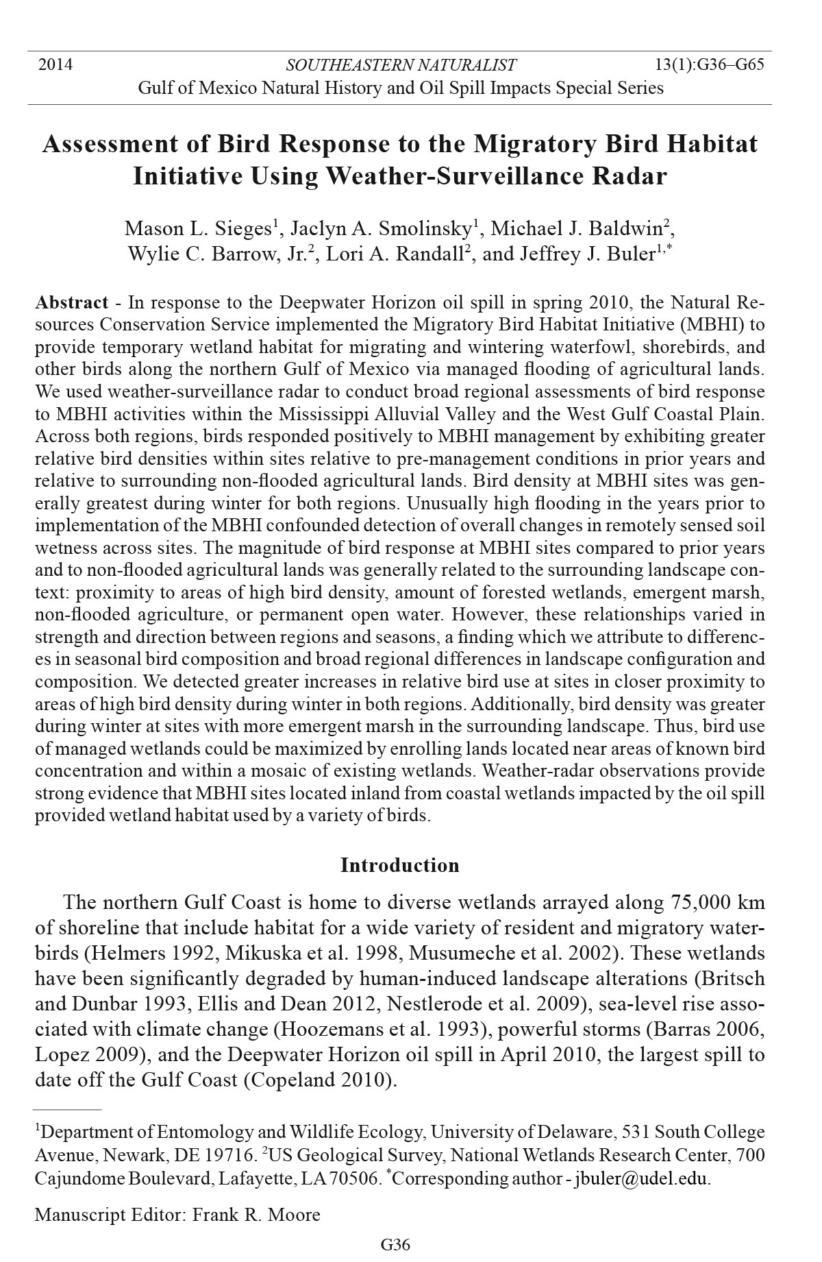
Figure 4. Images of remotely-sensed soil-wetness and radar-reflectivity data at 8 MBHI
sites (outlined) within Louisiana. As depicted by imagery from single dates, MBHI sites are
mostly flooded by surface water during the management year (top right panel) and relatively
dry during a prior year (top left panel). Mean standardized radar reflectivity at the onset of
evening flight (i.e., relative bird density) is greater within and around MBHI sites during the
winter of the management year (bottom right panel) than during the previous two winters
(bottom left panel).
Southeastern Naturalist
M.L. Sieges, J.A. Smolinsky, M.J. Baldwin, W.C. Barrow, Jr., L.A. Randall, and J.J. Buler
2014 Vol. 13, No. 1
G50
moist-soil–management techniques for shorebirds, and the higher soil wetness in
winter is consistent with the open-water-management methodology used for wintering
waterfowl.
Bird-response modeling
Fall. During fall, the global models generally explained less than half of the
variation in relative bird density within the management year (Table 5) and relative
to prior years (Table 6). At both radars within the WGCP, the most important variable
in explaining bird density within the management year was proximity to areas
of high bird density, such that bird density on MBHI sites increased with proximity
to high bird-density areas. Additionally, bird density at Texas sites increased with
greater soil wetness. Within central Arkansas, however, the amount of forested
wetlands in the landscape was most important in explaining bird density within the
management year, such that bird density was higher at sites located near forested
wetlands. The importance and direction of the relationship of variables explaining
the change in bird density relative to prior years differed among all three radars
(Table 6). In Texas, MBHI areas with less nearby open water and forested wetland
and greater emergent marsh had a greater increase in density relative to prior years.
In Louisiana, MBHI areas located near sites with high bird-density areas and with
more open water had a greater increase in density relative to prior years. In central
Arkansas, MBHI areas farther from high bird-density areas and with lower soil wetness
relative to prior years had a greater increase in density relative to prior years.
Winter. During winter, the global models generally explained >70% of the variation
in relative bird density within the management year (Table 7). At all radars, the
most important variable in explaining standardized bird density within the management
year was proximity to areas of high bird density, such that bird density was
higher on MBHI sites located near high bird-density areas. Additionally, within the
WGCP, bird density was positively related to greater amounts of emergent marsh in
the surrounding area. In Louisiana, MBHI sites with more non-flooded agriculture
and higher soil wetness also had greater bird density. In Arkansas, MBHI areas with
more non-flooded agriculture and open water in the landscape had greater standardized
bird density in the management year.
During winter, the global models did not explain as much variability in bird
density relative to prior years as they did for standardized bird density within the
management year; however, they still explained >50% of the variation (Table 8).
The variation in winter bird density relative to prior years was explained by greater
amounts of emergent marsh in the surrounding landscape at both WGCP radars.
Otherwise, the importance and direction of the relationship of variables explaining
the change in bird density relative to prior years differed among all three radars.
In Texas, MBHI sites that were located closer to areas of high bird density and had
less open water also had a greater increase in density relative to prior years. In
Louisiana, MBHI areas with greater non-flooded agriculture and a larger increase in
soil wetness also had a greater increase in density relative to prior years. In central
Arkansas, MBHI areas with more open water and forested wetland had a greater
increase in density relative to prior years.
Southeastern Naturalist
G51
M.L. Sieges, J.A. Smolinsky, M.J. Baldwin, W.C. Barrow, Jr., L.A. Randall, and J.J. Buler
2014 Vol. 13, No. 1
Table 5. Mean relative variable importance, mean effect size and effect frequency of explanatory variables in explaining fall standardized bird density within
the management year at MBHI areas based on a candidate set of linear regression models (63 models for KLCH and KHGX, 31 models for KLZK). Each
model set assessed using a set of 25 samples with 20 sample polygons for each sampling set. Effect size is the mean standardized regression coefficient
across all models averaged across sample sets ± unconditional SE. Effect frequency is the proportion of sample sets for which the variable exhibited a strong
effect. Characteristic scale (landscape radius in km) at which each land-cover type was quantified in parentheses. The mean global model R2 values were
0.48 (KLCH), 0.54 (KHGX), and 0.40 (KLZK). * indicates the variable of greatest importance and other variables with importance above 0.5 and/or effect
frequency above 0.33.
KLCH KHGX KLZK
Mean Mean Mean
Mean effect Effect Mean effect Effect Mean effect Effect
Explanatory variable importance size ± SE frequency importance size ± SE frequency importance size ± SE frequency
Soil-wetness index 0.38 -0.12 ± 0.11 0.28 0.58* 0.39 ± 0.07* 0.56* 0.39 -0.11±0.06 0.28
Non-flooded agriculture (4.5/4.5/0.5 km) 0.34 -0.20 ± 0.06 0.12 0.33 0.16 ± 0.13 0.12 0.42 0.18 ± 0.08 0.24
Forested wetland (2.5/2.5/4.5 km) 0.33 0.06 ± 0.08 0.16 0.29 -0.03 ± 0.05 0.16 0.58* 0.37 ± 0.10* 0.48*
Permanent open water (3.0/4.0/4.5 km) 0.46 0.35 ± 0.03 0.24 0.40 -0.31 ± 0.04 0.24 0.32 -0.06 ± 0.05 0.12
Proximity to high bird-density area 0.47* -0.33 ± 0.14* 0.32* 0.61* -0.44 ± 0.04* 0.60* 0.35 -0.14 ± 0.06 0.16
Emergent marsh (4.5/3.5/n/a km) 0.35 -0.24 ± 0.13 0.08 0.38 0.19 ± 0.16 0.16 n/a n/a n/a
Southeastern Naturalist
M.L. Sieges, J.A. Smolinsky, M.J. Baldwin, W.C. Barrow, Jr., L.A. Randall, and J.J. Buler
2014 Vol. 13, No. 1
G52
Table 6. Mean relative variable importance, mean effect size and effect frequency of explanatory variables in explaining fall ratio of bird density during the
management year relative to the prior two years at MBHI areas based on a candidate set of linear regression models (63 models for KLCH and KHGX, 31
models for KLZK). Each model set assessed using a set of 25 samples with 20 sample polygons for each sampling set. Effect size is the mean standardized
regression coefficient across all models averaged across sample sets ± unconditional SE. Effect frequency is the proportion of sample sets for which the variable
exhibited a strong effect. Characteristic scale (landscape radius in km) at which each land-cover type was quantified in parentheses. The mean global
model R2 values were 0.45 (KLCH), 0.58 (KHGX), and 0.41 (KLZK). * indicates the variable of greatest importance and other variables with importance
above 0.5 and/or effect frequency above 0.33.
KLCH KHGX KLZK
Mean Mean Mean
Mean effect Effect Mean effect Effect Mean effect Effect
Explanatory variable importance size ± SE frequency importance size ± SE frequency importance size ± SE frequency
Change in soil-wetness index 0.31 -0.04 ± 0.06 0.08 0.39 0.09 ± 0.10 0.28 0.46* -0.18 ± 0.09* 0.36*
Non-flooded agriculture (1.0/4.5/4.5 km) 0.34 0.12 ± 0.07 0.12 0.43 0.47 ± 0.16 0.32 0.34 -0.10 ± 0.05 0.16
Forested wetland (1.5/4.5/0.5 km) 0.32 0.14 ± 0.06 0.16 0.48* -0.38 ± 0.06* 0.40* 0.30 -0.08 ± 0.04 0.08
Permanent open water (4.0/3.0/2.0 km) 0.50* 0.35 ± 0.07* 0.40* 0.55* -0.43 ± 0.07* 0.48* 0.34 0.08±0.06 0.20
Proximity to high bird-density area 0.52* -0.33 ± .10* 0.44* 0.29 0.10 ± 0.06 0.04 0.59* 0.37 ± 0.03* 0.52*
Emergent marsh (4.5/2.0/n/a km) 0.37 -0.03 ± 0.13 0.16 0.49* 0.41 ± 0.16* 0.36* n/a n/a n/a
Southeastern Naturalist
G53
M.L. Sieges, J.A. Smolinsky, M.J. Baldwin, W.C. Barrow, Jr., L.A. Randall, and J.J. Buler
2014 Vol. 13, No. 1
Table 7. Mean relative variable importance, mean effect size and effect frequency of explanatory variables in explaining winter standardized bird density
within the management year at MBHI areas based on a candidate set of linear regression models (63 models for KLCH and KHGX, 31 models for KLZK).
Each model set assessed using a set of 25 samples with 20 sample polygons for each sampling set. Effect size is the mean standardized regression coefficient
across all models averaged across sample sets ± unconditional SE. Effect frequency is the proportion of sample sets for which the variable exhibited a strong
effect. Characteristic scale (landscape radius in km) at which each land-cover type was quantified in parentheses. The mean global model R2 values were
0.88 (KLCH), 0.71 (KHGX), and 0.86 (KLZK). * indicates the variable of greatest importance and other variables with importance above 0.5 and/or effect
frequency above 0.33.
KLCH KHGX KLZK
Mean Mean Mean
Mean effect Effect Mean effect Effect Mean effect Effect
Explanatory variable importance size ± SE frequency importance size ± SE frequency importance size ± SE frequency
Soil-wetness index 0.44* 0.16 ± 0.02* 0.36* 0.36 0.01 ± 0.06 0.24 0.37 0.11 ± 0.01 0.28
Non-flooded agriculture (4.0/3.5/4.5 km) 0.70* 0.33 ± 0.03* 0.72* 0.33 -0.04 ± 0.17 0.16 0.49* 0.27 ± 0.02* 0.36*
Forested wetland (4.0/0.5/4.5 km) 0.28 0.06 ± 0.04 0.16 0.25 0.06 ± 0.02 0.04 0.36 0.15 ± 0.02 0.20
Permanent open water (4.5/4.5/4.5 km) 0.31 0.04 ± 0.02 0.20 0.42 -0.26 ± 0.14 0.28 0.70* 0.29 ± 0.01* 0.76*
Proximity to high bird-density Area 0.91* -0.63 ± 0.04* 0.92* 0.78* -0.54 ± 0.06* 0.80* 1.00* -0.70 ± 0.01* 1.00*
Emergent marsh (1.5/ 4.5/n/a km) 0.69* 0.32 ± 0.03* 0.68* 0.78* 0.65 ± 0.08* 0.80* n/a n/a n/a
Southeastern Naturalist
M.L. Sieges, J.A. Smolinsky, M.J. Baldwin, W.C. Barrow, Jr., L.A. Randall, and J.J. Buler
2014 Vol. 13, No. 1
G54
Table 8. Mean relative variable importance, mean effect size and effect frequency of explanatory variables in explaining winter ratio of bird density during
the management year relative to the prior two years at MBHI areas based on a candidate set of linear regression models (63 models for KLCH and KHGX,
31 models for KLZK). Each model set assessed using a set of 25 samples with 20 sample polygons for each sampling set. Effect size is the mean standardized
regression coefficient across all models averaged across sample sets ± unconditional SE. Effect frequency is the proportion of sample sets for which the
variable exhibited a strong effect. Characteristic scale (landscape radius in km) at which each land-cover type was quantified in parentheses. The mean global
model R2 values were 0.68 (KLCH), 0.57 (KHGX), and 0.51 (KLZK). * indicates the variable of greatest importance and other variables with importance
above 0.5 and/or effect frequency above 0.33.
KLCH KHGX KLZK
Mean Mean Mean
Mean effect Effect Mean effect Effect Mean effect Effect
Explanatory variable importance size ± SE frequency importance size ± SE frequency importance size ± SE frequency
Change in soil-wetness Index 0.57* 0.34 ± 0.03* 0.68* 0.36 0.00 ± 0.09 0.24 0.33 0.15 ± 0.03 0.16
Non-flooded agriculture (4.5/1.5/4.5 km) 0.73* 0.53 ± 0.05* 0.76* 0.39 0.07 ± 0.14 0.24 0.40 -0.20 ± 0.09 0.24
Forested wetland (3.5/3.5/3.5 km) 0.40 0.11 ± 0.11 0.32 0.41 -0.08 ± 0.16 0.24 0.55* 0.34 ± 0.10* 0.44*
Permanent open water (4.0/4.5/2.0 km) 0.38 0.05 ± 0.05 0.28 0.47* -0.37 ± 0.12* 0.40* 0.55* 0.34 ± 0.04* 0.48*
Proximity to high bird-density area 0.31 -0.01 ± 0.08 0.16 0.44* -0.24 ± 0.11* 0.36* 0.37 0.23 ± 0.02 0.16
Emergent marsh (1.0/3.5/n/a km) 0.56* 0.33 ± 0.03* 0.52* 0.63* 0.57 ± 0.18* 0.56* n/a n/a n/a
Southeastern Naturalist
G55
M.L. Sieges, J.A. Smolinsky, M.J. Baldwin, W.C. Barrow, Jr., L.A. Randall, and J.J. Buler
2014 Vol. 13, No. 1
Discussion
We used weather-surveillance radar to quantify relative bird densities at the onset
of evening flights to determine the efficacy of the MBHI in providing diurnal habitat
for waterbirds across a broad spatial and temporal scale. Our analysis indicated that
on the majority of managed MBHI lands, bird densities increased when compared to
prior non-managed years and were often higher than densities found on surrounding
non-flooded agricultural land. There were marked differences in relative magnitude
of bird responses across seasons and regions, with the greatest bird responses
to MBHI management observed within the WGCP region during winter. For example,
winter bird use on over 90% of radar-observed MBHI area within Louisiana
increased by an average of over 10 times relative to previous years. The density of
birds was lower and their relative responses were weaker during the fall, likely due
to the short duration and late timing of fall management with respect to shorebird
migration. The weakest bird response to MBHI activities was during spring in the
WGCP, for which we could not remotely assess moist soil management. We expected
to see temporal and geographic differences because bird numbers and species composition
changed during different management periods and in space due to differences
in local and regional characteristics of the landscape.
Various groups of birds migrate through the area throughout the year; land birds
and shorebirds pass through first in spring and fall followed by waterfowl that often
stay through the winter (Tamisier 1976). We analyzed fall management activities
that occurred during October, when the majority of shorebirds had already passed
through and only a few species, such as Limnodromus spp. (dowitchers), Calidris
minutilla (Least Sandpiper) and Tringa spp. (yellowlegs), were still migrating (Ranalli
and Ritchison 2012, Robbins and Easterla 1991, Twedt et al. 1998). Land-bird
migration, however, is near its peak along the Gulf Coast in October (Gauthreaux
and Belser 1999). Flights of early migrant waterfowl such as Northern Pintail and
Anas discors L. (Blue-winged Teal) begin as early as September (Cox and Afton
1996, 1997; eBird 2013; Tamisier 1976), but the first big influx of wintering waterfowl
generally occurs in early November (Tamisier 1976). Based on surveys
conducted around sunset (i.e., close to when NEXRAD sampled the airspace over
MBHI sites), waterfowl and wading birds were generally more abundant in the
airspace than land birds and shorebirds over MBHI fields in Louisiana during the
month of October 2011 (W.C. Barrow, unpubl. data). Thus, radars would have observed
a mix of land birds, shorebirds, and early waterfowl engaging in evening
migratory flights during October. The presence of diverse species during evening
flights, especially migrating land birds, may account for in part why our models
explained less variability in fall bird densities for both regions compared to variability
in winter densities.
During fall management in the MAV, when migrating land birds were dominant,
bird densities at MBHI sites were positively associated with forested wetlands.
Areas with more forested wetlands in the surrounding area had higher bird densities
during the management year, likely indicating of the presence of migrating land
birds from adjacent forested habitats where land-bird migrants are known to
Southeastern Naturalist
M.L. Sieges, J.A. Smolinsky, M.J. Baldwin, W.C. Barrow, Jr., L.A. Randall, and J.J. Buler
2014 Vol. 13, No. 1
G56
concentrate (Buler and Moore 2011, Gauthreaux and Belser 1999). Additionally,
some waterfowl species such as Anas crecca L. (Green-winged Teal) and Northern
Pintail use forested wetlands in the MAV throughout the spring and fall (Heitmeyer
1985). Our data also indicate that many sites in the MAV were not actually flooded
in October and that drier sites were weakly associated with a greater increase in bird
density in the management year relative to prior years. During fall management in
the MAV, sites were drier than those in the Gulf, and observed bird densities may
reflect shorebirds using drier mudflat sites, land birds (e.g. blackbirds) en route to
their roosts, or neotropical migrant land birds departing the nearby forested wetlands
and utilizing the landscape adjacent to the sites.
During fall and winter, the only variable that exhibited a consistent relationship
with bird density between the two radars within the WGCP was proximity to a high
bird-density area. Established areas of high waterbird densities and the tendency of
waterbirds to form traditional large roosting flocks (Tamisier 1985) are two likely
reasons why we saw greater increases at sites close to high bird-density areas. Large
concentrations of waterfowl have historically used the marshes and adjacent wetprairie
lands situated along the Gulf Coast (Bateman et al. 1988, Bellrose 1976,
Tamisier 1976). An estimated 4 million ducks and hundreds of thousands of geese
wintered in coastal Louisiana in the late 1960s (Lynch 1975, Tamisier 1976), with
a more recently estimated 4 million waterfowl in coastal Texas (US Fish and Wildlife
Service 1999). The MAV has also historically harbored millions of waterfowl,
with the number of wintering Anas platyrhynchos L. (Mallards) estimated at 1.5
million (Bellrose 1976). A great portion of the extensive coastal prairie and its associated
wetlands along the Gulf Coast support waterbirds, including portions of
their historic winter ranges (Eadie et al. 2008), has been converted for rice and other
agricultural products, altering the landscape and bird distributions (Hobaugh et al.
1989). Similarly, much of the forested wetland area of the MAV was converted for
agricultural use throughout the last century (Forsythe 1985). Despite these changes,
the WGCP and the MAV remain two of the most important regions for migrating
and wintering waterbirds in North America (Bellrose 1976) as evidenced by the
millions of birds that feed and roost in their agricultural fields each year (Hobaugh
et al. 1989, Remsen et al. 1991).
Communal roosting is characteristic of many shorebird and waterfowl species
(Colwell 2010, Tamisier 1976). Some birds use the same winter roost or feeding
sites year after year (Tamisier 1985). For example, Cox and Afton (1996) reported
high fidelity (71%) of radio-marked female Northern Pintails to Lacassine National
Wildlife Refuge in coastal Louisiana following nightly foraging trips to nearby
agricultural land. Additionally, although changes in flooding occurred on the landscape
throughout the winter, ducks maintained consistent flight directions when
leaving Lacassine National Wildlife Refuge (Tamisier 1976). Within Louisiana,
radar observations indicate birds are concentrated in marsh and agricultural areas
within and around Lacassine and Cameron Prairie National Wildlife Refuges and
the White Lake Wetlands Conservation Area, all of which are well-known roosting
areas for wintering waterfowl (Link et al. 2011). These findings support the idea
Southeastern Naturalist
G57
M.L. Sieges, J.A. Smolinsky, M.J. Baldwin, W.C. Barrow, Jr., L.A. Randall, and J.J. Buler
2014 Vol. 13, No. 1
that birds consistently use certain areas during the winter and that these sites may
be important predictors of waterbird activity.
Regional habitat differences associated with emergent marsh also influenced differential
bird responses across the sites. Our finding that increased bird densities at
sites in the WGCP region were related to larger amounts of emergent marsh in the
surrounding landscape highlights the importance of emergent marsh in predictions
of winter bird densities. Generally, waterfowl use of natural wetlands is positively
related to the extent of wetlands in the local landscape (Brown and Dinsmore 1986,
Fairbairn and Dinsmore 2001, McKinstry and Anderson 2002, Stafford et al. 2007,
Webb et al. 2010). Wetland habitats have traditionally supported many waterbirds
and are important wintering grounds for ducks and other waterfowl (Tasimier 1976).
For example, Link (2011) found that Mallards could acquire most of their energetic
requirements from or in close proximity (3–15 km) to marsh habitats even though
they engaged in routine flights between diurnal roost sites in marsh and nocturnal foraging
sites in agricultural fields. Emergent marshes are often part of large and diverse
wetland complexes (Cowardin et al. 1979) that support a diversity of birds (Brown
and Dinsmore 1986). Wetland complexes in various stages of succession have proven
to be the most beneficial to waterbirds (Fredrickson and Reid 1986, Kaminski et al.
2006, Murkin and Caldwell 2000, Van der Valk 2000, Webb et al. 2010).
During winter in the MAV, reflectivity was relativelygreater at sites with more
forested wetlands and permanent open water in the landscape relative to the baseline
years. In the winter of the management year, the Arkansas Game and Fish
Commission (AGFC) noted that waterfowl may have shifted to using more forested
wetlands when abnormally cold temperatures produced ice on much of the
open water associated with agricultural fields (AGFC 2010a, b). Additionally, dry
conditions across Arkansas that winter contributed to a lack of temporary water on
the landscape, likely explaining the positive relationship between permanent open
water and bird density.
Within Arkansas, waterfowl numbers peaked during December 2010 based on
aerial surveys (AAGFC 2011a), consistent with the peak in radar reflectivity in the
MAV during that time. However, waterfowl numbers were later reduced by 50%
during January compared to the previous year likely due to dry conditions across
Arkansas (AGFC 2011b). Subsequently, waterfowl numbers in Louisiana increased
by 21% relative to the previous year in January 2011 (Louisiana Department of
Wildlife and Fisheries 2011). Accordingly, radar reflectivities in Louisiana peaked
during January 2011.
Although we detected some increases in bird density during spring management
in the WGCP region, the increases were slight. Lack of wetness data and few
enrolled sites prevented us from investigating how site and landscape variables
influenced bird densities. Some water birds may have already departed on migration
during the month of March (see Hobaugh et al. 1989). For example, Mallards
and Northern Pintails begin leaving wintering grounds in early February (Bellrose
1976), and the majority of ducks depart coastal Texas during the month of February,
with few left by mid-March (Hobaugh et al. 1989). A few shorebird species, such
Southeastern Naturalist
M.L. Sieges, J.A. Smolinsky, M.J. Baldwin, W.C. Barrow, Jr., L.A. Randall, and J.J. Buler
2014 Vol. 13, No. 1
G58
as Recurvirostra americana Gmelin (American Avocet), may leave Texas in early
March, (Oberholser 1974), but many shorebirds are present south of the WGCP
during March and into April (Withers and Chapman 1993). Alternatively, food
resources on local flooded fields may be too depleted by spring to support large
groups of waterbirds (Cox and Afton 1996, Hamilton and Watt 1970, Hobaugh et
al. 1989).
Increases in bird density occurred despite our finding that there was little or no
increase in soil wetness at the managed sites. The remotely sensed data that we
used to calculate the soil-wetness index may have limited our ability to detect such
changes. We had few usable images for each radar station per season with which to
calculate the index. Additionally, we had no information about the extent of flooding
within individual properties. Thus, a landowner’s contract may have required
flooding on only a portion of their property, and our analysis may have included the
whole property boundary. Moreover, drought conditions, restricted water supplies,
or other circumstances may have prevented landowners from complying fully with
their contracts.
Soil-wetness values in the MAV region were undoubtedly influenced by natural
fluctuations in precipitation patterns. The baseline years comprised a relatively wet
period in the MAV; October 2009 in Arkansas was the wettest October recorded
in more than 100 years (NOAA National Climatic Data Center 2009). In contrast,
much of Arkansas was under drought conditions in 2010 (NOAA National Climatic
Data Center 2010). Thus, these conditions complicated quantification of changes in
site wetness (i.e., flooding) during the management year.
Variability in the intensity of moist soil management can have an important effect
on wintering waterfowl use (Kaminski et al. 2006, O’Neal et al. 2008). MBHI
sites in the MAV and those in Texas received minimal modifications. In the MAV,
contracts simply required landowners to keep surface water on their fields for a
specified amount of time across a wide range of depths (5–46 cm) to potentially
benefit a variety of shorebirds and wading birds. Surface-water depths are difficult
to measure remotely. Regular water-depth measurements in the field would have
allowed us to better quantify habitat for particular taxa of wa terbirds.
Ranalli and Ritchison (2012) note that mudflat habitat associated with agricultural
fields is unpredictable in the MAV because it is precipitation-dependent and
varies annually. Thus, management activities associated with the MBHI may have
provided stopover habitat for migrating shorebirds. Landowners may have been
unable to maintain winter flooding at depths that would benefit waterfowl, but any
water on the fields likely benefited shorebirds because they are known to identify
and use saturated soils within days of being inundated (Skagen and Knopf 1993,
Skagen et al. 2008).
The attractiveness of MBHI wetlands to waterfowl may have varied based on the
land use of sites prior to flooding. Some fields were pastures (15% in the MAV, 20%
in the WCGP; USDA NASS CDL 2010) during the management year and may not
have provided much forage in the form of wetland plant seeds during the first year of
the program. Rice seeds persist longer in wetlands than other seeds associated with
Southeastern Naturalist
G59
M.L. Sieges, J.A. Smolinsky, M.J. Baldwin, W.C. Barrow, Jr., L.A. Randall, and J.J. Buler
2014 Vol. 13, No. 1
crop-harvest waste, thereby potentially increasing available forage for waterbirds
compared to other flooded crops (Nelms and Twedt 1996). However, only 20% of
MBHI sites in the MAV were rice fields, compared to 40% in the WGCP (USDA
NASS CDL 2010), which may account for greater positive changes in reflectivity
values in the WCGP. Although waterfowl feed on non-flooded waste grain (Bellrose
1976, Kross et al. 2008, Reinecke et al. 1989), flooding rice fields increases habitat
for waterfowl and other waterbirds in California (Elphick and Oring 1998).
Buler et al. (2012b) found that waterfowl use of restored wetlands was negatively
related to the amount of wetlands in the local landscape and speculated
that this may be because newly restored wetlands were lower-quality habitat than
natural wetlands. Similarly, studies have found that flooded agricultural fields do
not necessarily act as surrogates for natural wetlands (Bartzen et al. 2010, Czech
and Parsons 2002). Ma et al. (2004) found that although natural wetlands provided
better habitat, artificial wetlands attracted some waterbird species during winter.
Because portions of the MAV and WGCP have been farmed for rice each year in the
last 150 years or so (Hobaugh et al. 1989), waterbirds may be dependent on flooded
agricultural fields for wintering habitat, in which case the MBHI provided valuable
habitat that landowners otherwise might not have flooded in a dr ought year.
In the wake of a major environmental disaster, the MBHI program provided water
birds with temporary wetland habitats by flooding agricultural fields in the MAV and
WGCP regions. We detected increases in bird densities on the majority of MBHI sites
during migration and wintering periods for waterfowl and shorebirds. The greatest
relative responses by birds to MBHI sites occurred in the WGCP during the winter
management period at sites closer to areas of high previously documented bird density
and with more emergent marsh in the surrounding landscape. We are currently
conducting a more detailed analysis of bird use at Louisiana MBHI sites in the year
subsequent to this study with the addition of ground-survey data, thermal infrared
camera recordings, and portable radar observations. These data will provide more
insight into bird-use patterns of MBHI sites. For example, our portable radar detected
birds using MBHI sites during the night. Bird use of managed lands may be
maximized if future enrollments are clustered into a mosaic of wetlands that more
closely resemble natural wetland complexes (Brown and Dinsmore 1986). Because
predicted climactic changes (Intergovernmental Panel on Climate Change 2007) will
likely cause alterations in sites used by wetland-dependent birds, providing habitat
for migratory birds in the MAV and WGCP will continue to be important for all
stakeholders, particularly with the knowledge that migration is a limiting factor for
shorebird and waterfowl success (Afton et al. 1991, Alisauskas and Ankney 1992,
Baker et al. 2004, Blums et al. 2005, Morrison et al. 2007, Ryder 1970).
Acknowledgments
We thank the Natural Resources Conservation Service for funding. The following personnel
from the NRCS provided geospatial data, management activity, and/or other related
information on MBHI fields: J. Pitre, R. Cheveallier, F. Chapman, S. Romero, B. Lyons, J.
Haller, C. Stemmons, J. Baker, G. Clardy, R. Castro, G. Barnett, D. Manthei, P. Stewart,
Southeastern Naturalist
M.L. Sieges, J.A. Smolinsky, M.J. Baldwin, W.C. Barrow, Jr., L.A. Randall, and J.J. Buler
2014 Vol. 13, No. 1
G60
and R. Villarreal. We also thank J. Gautreaux, R. Lyon, and D. Greene for screening radar
data. Any use of trade, product, or firm names is for descriptive purposes only and does not
imply endorsement by the US Government.
Literature Cited
Afton, A.D., R.H. Hier, and S.L. Paulus. 1991. Lesser Scaup diets during migration and
winter in the Mississippi flyway. Canadian Journal of Zoology 69:328–333.
Åkesson, S., T. Alerstam, and A. Hedenström. 1996. Flight initiation of nocturnal passerine
migrants in relation to celestial orientation conditions at twilight. Journal of Avian Biology
27:95–102.
Alisauskas, R.T., and C.D. Ankney. 1992. The cost of egg laying and its relationship to nutrient
reserves in waterfowl. Pp. 30–61, In B.D.J. Batt, A.D. Afton, M.G. Anderson, C.D.
Ankney, D.H. Johnson, J.A. Kadlec, and G.L.Krapu (Eds.). Ecology and Management of
Breeding Waterfowl. University of Minnesota Press, Minneapolis, MN.
Alsdorf, D.E., E. Rodríguez, and D.P. Lettenmaier. 2007. Measuring surface water from
space. Reviews of Geophysics 45.
Arkansas Game and Fish Commission (AGFC). 2010a. Weekly waterfowl report, 24 November
2010.Little Rock, AR.
AGFC. 2010b. Weekly waterfowl report, 22 December 2010.
AGFC. 2011a. Duck observations in the Arkansas Delta: 27 December2010–6 January
2011.
AGFC. 2011b. Duck observations in the Arkansas Delta: 4 January 2011–6 January 2011.
AGFC. 2011c. Weekly waterfowl report, 19 January 2011.
Baker, A.J., P.M. Gonzalez, T. Piersma, L.J. Niles, I. de Lima Serrano do Nascimento, P.W.
Atkinson, N.A. Clark, C.D.T. Minton, M.K. Peck, and G. Aarts. 2004. Rapid population
decline in Red Knots: Fitness consequences of decreased refueling rates and late arrival
in Delaware Bay. Proceedings of the Royal Society B: Biological Sciences 271:875–882.
Baker, C., R.L. Lawrence, C. Montagne, and D. Patten. 2007. Change detection of wetland
ecosystems using Landsat imagery and change vector analysis. Wetlands 27:610–619.
Baldassarre, G.A., and E.G. Bolen. 1984. Field-feeding ecology of waterfowl wintering
on the Southern High Plains of Texas. The Journal of Wildlife Management 48:63–71.
Barras, J.A. 2006. Land-area change in coastal Louisiana after the 2005 hurricane. A series
of three maps. Open-File Report No. 06-1274. USGS, Baton Rouge, LA.
Bartzen, B.A., K.W. Dufour, R.G. Clark, and F.D. Caswell. 2010. Trends in agricultural impact
and recovery of wetlands in prairie Canada. Ecological Applications 20:525–538.
Bateman, H.A., T. Joaenen, and C.D. Stutzenbaker. 1988. History and status of midcontinent
Snow Geese on their Gulf Coast winter range. Pp. 495–515, In M.W. Weller (Ed.).
Waterfowl in Winter. University of Minnesota Press, Minneapolis, MN.
Bellrose, F.C. 1976. Ducks, Geese, and Swans of North America. Second Edition. Stackpole
Books, Harrisburg, PA.
Blums, P., J.D. Nichols, J.E. Hines, M.S. Lindberg, and A. Mednis. 2005. Individual quality,
survival variation, and patterns of phenotypic selection on body condition and timing of
nesting in birds. Oecologia 143:365–376.
Bonter, D.N., T.M. Donovan, E.W. Brooks, and K.A. Hobson. 2007. Daily mass changes
in land birds during migration stopover on the south shore of Lake Ontario. Auk
124:122–133.
Bonter, D.N., S.A. Gauthreaux, Jr., and T.M. Donovan. 2009. Characteristics of important
stopover locations for migrating birds: Remote sensing with radar in the Great Lakes
basin. Conservation Biology 23:440–448.
Southeastern Naturalist
G61
M.L. Sieges, J.A. Smolinsky, M.J. Baldwin, W.C. Barrow, Jr., L.A. Randall, and J.J. Buler
2014 Vol. 13, No. 1
Britsch, L.D., and J.B. Dunbar. 1993. Land-loss rates: Louisiana Coastal Plain. Journal of
Coastal Research 9:324–338.
Brown, M., and J.J. Dinsmore. 1986. Implications of marsh size and isolation for marshbird
management. Journal of Wildlife Management 50:392–397.
Buler, J.J., and R.H. Diehl. 2009. Quantifying bird density during migratory stopover using
weather-surveillance radar. IEEE Transactions on Geoscience and Remote Sensing
47:2741–2751.
Buler, J.J., and F.R. Moore. 2011. Migrant–habitat relationships during stopover along an
ecological barrier: Extrinsic constraints and conservation implications. Journal of Ornithology
152:S101–S112.
Buler, J.J., L.A. Randall, J.P. Fleskes, W.C. Barrow, T. Bogart, and D. Kluver. 2012a.
Mapping wintering waterfowl distributions using weather-surveillance radar. PloS One
7:e41571.
Buler, J.J., W. Barrow, Jr., and L. Randall. 2012b. Wintering Waterfowl Respond to Wetlands
Reserve Program Lands in California’s Central Valley. USDA NRCS CEAP Conservation
Insight. Available online at http://www.nrcs.usda.gov/Internet/FSE_DOCUMENTS/
stelprdb1048508.pdf. Accessed 31 March 2013.
Burnham, K.P., and D.R. Anderson. 2002. Model Selection and Multimodel Inference:
A Practical Information-theoretic Approach. Second Edition. Springer-Verlag, New
York, NY.
Colwell, M.A. 2010. Shorebird Ecology, Conservation, and Management. University of
California Press, Berkeley, CA.
Copeland, C. 2010. Wetlands: An overview of issues. Congressional Research Service,
RL33483, Washington, DC.
Cowardin, L.M., V. Carter, F.C. Golet, and E.T. LaRoe. 1979. Classification of wetlands and
deepwater habitats of the United States. Office of Biological Services, Fish and Wildlife
Services, US Department of the Interior, Washington, DC.
Cox, R.R., Jr., and A.D. Afton. 1996. Evening flights of female Northern Pintails from a
major roost site. Condor 98:810–819.
Cox, R.R., Jr., and A.D. Afton. 1997. Use of habitats by female Northern Pintails wintering
in southwestern Louisiana. The Journal of Wildlife Management 61:435–443.
Crist, E.P. 1985. A TM tasseled cap equivalent transformation for reflectance factor data.
Remote Sensing of Environment 17:301–306.
Crum, T.D., and R.L. Alberty. 1993. The WSR-88D and the WSR-88D operational support
facility. Bulletin of the American Meteorological Society 74:1669–1688.
Czech, H.A., and K.C. Parsons. 2002. Agricultural wetlands and waterbirds: A review.
Waterbirds 25(Special Publication 2):56–65.
Diehl, R.H., R.P. Larkin, J.E. Black, and F.R. Moore. 2003. Radar observations of bird
migration over the Great Lakes. Auk 120:278–290.
Eadie, J.M., C.S. Elphick, K.J. Reinecke and M.R. Miller. 2008. Wildlife values of North
American ricelands. Pp. 7–90, In S.W. Manley (Ed.). Conservation in ricelands of North
America. The Rice Foundation, Stuttgart, AR.
eBird. 2013. eBird: An online database of bird distribution and abundance. Available online
at http://www.ebird.org. Accessed Accessed 31 March 2013.
Ellis, J.T., and B.J. Dean. 2012. Gulf of Mexico processes. Journal of Coastal Research:
Special Issue 60:6–13.
Elphick, C.S. 2000. Functional equivalency between rice fields and seminatural wetland
habitats. Conservation Biology 14:181–191.
Southeastern Naturalist
M.L. Sieges, J.A. Smolinsky, M.J. Baldwin, W.C. Barrow, Jr., L.A. Randall, and J.J. Buler
2014 Vol. 13, No. 1
G62
Elphick, C.S., and L.W. Oring. 1998. Winter management of Californian rice fields for
waterbirds. Journal of Applied Ecology 35:95–108.
Ely, C.R. 1992. Time allocation by Greater White-fronted Geese: Influence of diet, energy
reserves, and predation. Condor 94:857–870.
Fairbairn, S.E., and J.J. Dinsmore. 2001. Local and landscape-level influences on wetland
bird communities of the Prairie Pothole Region of Iowa, USA. Wetlands 21:41–47.
Floyd, M.D. 2000. Birds of Acadia Parish, Louisiana. Natural Resources Conservation
Service, Alexandria, LA.
Forsythe, S.W. 1985. The protection of bottomland hardwood wetlands of the lower Mississippi
Valley. Transactions of the North American Wildlife and Natural Resources
Conference 50:566–572.
Frederickson, L.H., and F.A. Reid. 1986. Wetland and riparian habitats: A nongame management
overview. Pp. 59–96, In J.B. Hale, L.B. Best, and R.L. Clawson (Eds.). Management
of Nongame Wildlife in the Midwest: A Developing Art. The Wildlife Society,
Grand Rapids, MI.
Gauthreaux, S.A., Jr. 1971. A radar and direct visual study of passerine spring migration in
southern Louisiana. Auk 88:343–365.
Gauthreaux, S.A., Jr., and C.G. Belser. 1998. Displays of bird movements on the WSR-88D:
Patterns and quantification. Weather and Forecasting 13:453–464.
Gauthreaux, S.A., Jr., and C.G. Belser. 2003. Radar ornithology and biological conservation.
The Auk 120:266–277.
Gauthreaux, S.A., and C.G. Belser. 1999. Bird migration in the region of the Gulf of
Mexico. Pp. 1931–1947, In N.J. Adams and R.H. Slotow (Eds.). Proceedings of the 22nd
International Ornithological Congress. Birdlife South Africa, Durban, South Africa.
Hamilton, W.J., and K.E. Watt. 1970. Refuging. Annual Review of Ecology and Systematics
1:263–286.
Hebrard, J.J. 1971. The nightly initiation of passerine migration in spring: A direct visual
study. Ibis 113:8–18.
Heitmeyer, M.E. 1985. Wintering strategies of female Mallards related to dynamics of lowland
hardwood wetlands in the upper Mississippi Delta. Ph.D. Dissertation. University
of Missouri, Columbia, MO.
Helmers, D.L. 1992. Shorebird Management Manual. Western Hemisphere Shorebird Reserve
Network. Manomet Center for Conservation Sciences. Manomet, MA.
Hobaugh, W.C., C.D. Stutzenbaker, and E.L. Flickinger. 1989. The rice prairies. Pp. 367–
383, In L.M. Smith, R.L. Pederson, and R.M. Kaminski (Eds.). Habitat Management
for Migrating and Wintering Waterfowl in North America. Texas Technical University
Press, Lubbock, TX.
Holland, J.D., D.G. Bert, and L. Fahrig. 2004. Determining the spatial scale of species’
response to habitat. BioScience 54:227–233.
Hoozemans, F.M.J., M. Marchand, and H.A. Pennekamp. 1993. A global vulnerability
analysis: Vulnerability Assessment for Population, Coastal Wetlands, and Rice Production
on a Global Scale. 2nd Edition. Delft Hydraulics, the Netherlands.
Huang, C., B. Wylie, L. Yang, C. Homer, and G. Zylstra. 2002. Derivation of a tasselled
cap transformation based on Landsat 7 at-satellite reflectance. International Journal of
Remote Sensing 23:1741–1748.
Huner, J.V. 1995. How crayfish impoundments sustain wetland vertebrates in the South. Pp.
32–40, In Proceedings of National Agricultural Ecosystem Management Conference.
Conservation Technology Center, West Lafayette, IN.
Southeastern Naturalist
G63
M.L. Sieges, J.A. Smolinsky, M.J. Baldwin, W.C. Barrow, Jr., L.A. Randall, and J.J. Buler
2014 Vol. 13, No. 1
Huner, J.V., C.W. Jeske, and W. Norling. 2002. Managing agricultural wetlands for waterbirds
in the coastal regions of Louisiana, USA. Waterbirds 25(Supplement 2):66–78.
Intergovernmental Panel on Climate Change. 2007. Climate change 2007: The physical
science basis. S. Soloman, D. Qin, M. Manning, Z. Chen, M. Marq uis, K.B. Averyt, M.
Tignor, and H.L. Miller (Eds.). Contribution of Working Group I to the Fourth Assessment
Report of the Intergovernmental Panel on Climate Change. Cambridge University
Press, Cambridge, UK.
Kaminski, M.R., G.A. Baldassarre, and A.T. Pearse. 2006. Waterbird responses to hydrological
management of wetlands reserve program habitats in New York. Wildlife Society
Bulletin 34:921–926.
Kelly, J.F., J.R. Shipley, P.B. Chilson, K.W. Howard, W.F. Frick, and T.H. Kunz. 2012.
Quantifying animal phenology in the aerosphere at a continental scale using NEXRAD
weather radars. Ecosphere 3:16.
Kross, J.P., R.M. Kaminski, K.J. Reinecke, and A.T. Pearse. 2008. Conserving waste rice
for wintering waterfowl in the Mississippi Alluvial Valley. Journal of Wildlife Management
72:1383–1387.
Link, P.T., A.D. Afton, R.R. Cox, and B.E. Davis. 2011. Daily movements of female Mallards
wintering in southwestern Louisiana. Waterbirds 34:422–428.
Lopez, J.A. 2009. The multiple lines of defense strategy to sustain coastal Louisiana. Journal
of Coastal Research 10054:186–197.
Louisiana Department of Wildlife and Fisheries. 2011. Aerial waterfowl survey, January
2011. Baton Rouge, LA.
Lynch, J.J. 1975. Winter ecology of Snow Geese on the Gulf Coast, 1925–1975. 37th Midwest
Fish and Wildlife Conference, Toronto, ON, Canada.
Ma, Z., B. Li, B. Zhao, K. Jing, S. Tang, and J. Chen. 2004. Are artificial wetlands good alternatives
to natural wetlands for waterbirds? A case study on Chongming Island, China.
Biodiversity and Conservation 13:333–350.
Manley, S.W., R.M. Kaminski, K.J. Reinecke, and P.D. Gerard. 2005. Agronomic implications
of waterfowl management in Mississippi ricefields. Wildlife Society Bulletin
33:981–992.
McKinstry, M.C., and S.H. Anderson. 2002. Creating wetlands for waterfowl in Wyoming.
Ecological Engineering 18:293–304.
Mikuska, T., J.A. Kushlan, and S. Hartley. 1998. Key areas for wintering North American
herons. Colonial Waterbirds 21:125–134.
Miller, M.R. 1985. Time budgets of Northern Pintails wintering in the Sacramento Valley,
California. Wildfowl 36:53–64.
Morrison, R.I.G., N.C. Davidson, and J.R. Wilson. 2007. Survival of the fattest: Body stores
on migration and survival in Red Knots, Calidris canutus islandica. Journal of Avian
Biology 38:479–487.
Murkin, H.R., and P.J. Caldwell. 2000. Avian use of prairie wetlands. Pp. 249–286, In H.R.
Murkin, A.G. van der Valk, and W.R. Clark (Eds.). Prairie Wetland Ecology: The Contribution
of the Marsh Ecology Research Program. University of Iowa Press, Ames, IA.
Musumeche, M.J., J.V. Huner, T. Mikuska, G. Richard, and B. Leonard. 2002. The avifauna
of an agricultural wetland complex in the Western Gulf Coastal Plain of Louisiana, USA.
Proceedings of the Louisiana Academy of Sciences 64:22–37.
Nelms, C.O., and D.J. Twedt. 1996. Seed deterioration in flooded agricultural fields during
winter. Wildlife Society Bulletin 24:85–88.
Southeastern Naturalist
M.L. Sieges, J.A. Smolinsky, M.J. Baldwin, W.C. Barrow, Jr., L.A. Randall, and J.J. Buler
2014 Vol. 13, No. 1
G64
Nestlerode, J.A., V.D. Engle, P. Bourgeois, P.T. Heitmuller, J.M. Macauley, and Y.C. Allen.
2009. An integrated approach to assess broad-scale condition of coastal wetlands: The
Gulf of Mexico coastal wetlands pilot survey. Environmental Monitoring and Assessment
150:21–29.
Niemuth, N.D., M.E. Estey, R.E. Reynolds, C.R. Loesch, and W.A. Meeks. 2006. Use of
wetlands by spring-migrant shorebirds in agricultural landscapes of North Dakota’s drift
prairie. Wetlands 26:30–39.
NOAA National Climatic Data Center. 2009. State of the Climate: National Overview for
Annual 2009. Available online at http://www.ncdc.noaa.gov/sotc/national/2009/13. Accessed
1 May 2013.
NOAA National Climatic Data Center. 2010. State of the Climate: National Overview for
Annual 2010. Available online at http://www.ncdc.noaa.gov/sotc/national/2010/13. Accessed
on 1 May 2013.
Norling, W., C.W. Jeske, T.F. Thigpen, and P.C. Chadwick. 2012. Estimating shorebird
populations during spring stopover in rice fields of the Louisiana and Texas Gulf Coastal
Plain. Waterbirds 35:361–370.
Oberholser, H.C. 1974. The Bird Life of Texas. Vol. 1. University of Texas Press, Austin, TX.
O’Neal, B.J., E.J. Heske, and J.D. Stafford. 2008. Waterbird response to wetlands restored
through the Conservation Reserve Enhancement Program. Journal of Wildlife Management
72:654–664.
Paulus, S.L. 1988. Time-activity budgets of nonbreeding Anatidae: A review. Pp. 135–
152, In M.W. Weller (Ed.). Waterfowl in Winter. University of Minnesota Press, Minneapolis,
MN.
Ranalli, N., and G. Ritchison. 2012. Phenology of shorebird migration in western Kentucky.
Southeastern Naturalist 11:99–110.
Randall, L.A., R.H. Diehl, B.C. Wilson, W.C. Barrow, and C.W. Jeske. 2011. Potential use
of weather radar to study movements of wintering waterfowl. The Journal of Wildlife
Management 75:1324–1329.
Raveling, D.G., W.E. Crews, and W.D. Klimstra. 1972. Activity patterns of Canada Geese
during winter. The Wilson Bulletin 84:278–295.
Reinecke, K.J., R.M. Kaminski, D.J. Moorhead, J.D. Hodges, and J.R. Nassar. 1989. Mississippi
Alluvial Valley. Pp. 203–248, In L.M. Smith, R.L. Pederson, and R.M. Kaminski
(Eds.). Habitat Management for Migrating and Wintering Waterfowl in North America.
Texas Tech University Press, Lubbock, TX.
Remsen, J.V., M.M. Swan, S.W. Cardiff, and K.V. Rosenberg. 1991. The importance of the
rice-growing region of south-central Louisiana to winter populations of shorebirds, raptors,
waders, and other birds. Journal of Louisiana Ornithology 1:35–47.
Robbins, M.B., and D.A. Easterla. 1991. Birds of Missouri: Their Distribution and Abundance.
University of Missouri, Columbia, MO.
Rodgers, J.A., Jr., and H.T. Smith. 1997. Buffer-zone distances to protect foraging and loafing
waterbirds from human disturbance in Florida. Wildlife Society Bulletin 25:139–145.
Ryder, J.P. 1970. A possible factor in the evolution of clutch size in Ross’ Goose. Wilson
Bulletin 82:5–13.
Skagen, S.K., D.A. Granfors, and C.P. Melcher. 2008. On determining the significance of
ephemeral continental wetlands to North American migratory shorebirds. Auk 125:20–29.
Skagen, S.K., and F.L. Knopf. 1993. Toward conservation of mid-continental shorebird
migrations. Conservation Biology 7:533–541.
Stafford, J.D., M.M. Horath, A.P. Yetter, C.S. Hine, and S.P. Havera. 2007. Wetland use
by Mallards during spring and fall in the Illinois and central Mississippi river valleys.
Waterbirds 30:394–402.
Southeastern Naturalist
G65
M.L. Sieges, J.A. Smolinsky, M.J. Baldwin, W.C. Barrow, Jr., L.A. Randall, and J.J. Buler
2014 Vol. 13, No. 1
Tamisier, A. 1976. Diurnal activities of Green-winged Teal and Pintail wintering in Louisiana.
Wildfowl 27:19–32.
Tamisier, A. 1985. Some considerations on the social requirements of ducks in winter.
Wildfowl 36:104–108.
Twedt, D.J., C.O. Nelms, V.E. Rettig, and S.R. Aycock. 1998. Shorebird use of managed
wetlands in the Mississippi Alluvial Valley. American Midland Naturalist 140:140–152.
USDA National Agricultural Statistics Service (NASS). 2010. Cropland Data Layer (CDL)
for the United States. USDA, NASS Marketing and Information Services Office, Washington,
DC. Available online at http://www.nass.usda.gov/research/Cropland/SARS1a.
htm. Accessed 31 March 2013.
USDA Natural Resources Conservation Service (NRCS). 2010. Shallow-water development
and management. Code 646. Handbook of conservation practices: Conservation
practice standard. Washington, DC. Available online at http://www.nrcs.usda.gov/Internet/
FSE_DOCUMENTS/nrcs143_026058.pdf. Accessed 31 March 2013.
USDA NRCS. 2012. Helping people help the land: Natural resource conservation in the
Gulf of Mexico. Washington, DC. Available online at http://www.nrcs.usda.gov/Internet/
FSE.Documents/sterlprdb1049256.pdf. Accessed 31 March 2013.
US Fish and Wildlife Service. 1999. Analyses of selected mid-winter waterfowl survey
data (1955–1999), Region 2 (Central Flyway portion). US Fish and Wildlife Service,
Albuquerque, NM.
van der Valk, A.G. 2000. Vegetation dynamics and models. Pp. 125–161, In H.R. Murkin,
A.G. van der Valk, and W.R. Clark (Eds.). Prairie Wetland Ecology: The Contribution of
the Marsh Ecology Research Program. Iowa State University, Ames, IA.
Webb, E.B., L.M. Smith, M.P. Vrtiska, and T.G. Lagrange. 2010. Community structure of
wetland birds during spring migration through the Rainwater Basin. Journal of Wildlife
Management 74:765–777.
Withers, K. and B.R. Chapman. 1993. Seasonal abundance and habitat use of shorebirds on
an Oso Bay mudflat, Corpus Christi, Texas. Journal of Field Ornithology 64:382–392.


 The Southeastern Naturalist is a peer-reviewed journal that covers all aspects of natural history within the southeastern United States. We welcome research articles, summary review papers, and observational notes.