2007 SOUTHEASTERN NATURALIST 6(2):217–234
Hydrogeomorphology and Forest Composition of Sunrise
Towhead Island in the Lower Mississippi River
Sabine Greulich1, Scott Franklin2,4,*, Thad Wasklewicz3,4,
and Jack Grubaugh2,4
Abstract - Forest vegetation was studied in relation to hydrogeomorphology on a
large fluvial island in the meandering section of the Lower Mississippi River. The
island has a relatively wide topographic gradient, including a former channel of
the Mississippi River. Vegetation patterns were related to geomorphologic features,
elevation, flood duration, and characteristics of surficial sediment. Overstory vegetation
was species rich for the island as a whole and dominated by the pioneer taxa
Populus deltoides (eastern cottonwood) and Salix nigra (black willow). Both pioneer
species dominated the old channel. Vegetation at higher elevations was characterized
by tree species from later successional stages such as Celtis laevigata (sugarberry),
Acer saccharinum (silver maple), Liquidambar styraciflua (sweetgum) and Ulmus
spp. (elm). Seedlings and saplings were dominated by sugarberry and other later
successional species, whereas cottonwood was infrequent. Our results suggest that
on the Lower Mississippi River, coexistence in the floodplain of pioneer stages and
later successional stages will not be perpetuated under the prevailing hydrologic
and geomorphologic regimes.
Introduction
Anthropogenic features, especially levees, have isolated many alluvial
floodplains of the Lower Mississippi River (LMR) (Johnson 1992, Knutson
and Klaas 1998, Nelson 1997, Peck and Smart 1986, Scott and Udouj 1999).
Large islands along the LMR that are still influenced by the river’s hydrologic
cycles harbour much of the remaining alluvial forests and may be
important reservoirs of biotic diversity. We examined one such island,
Sunrise Towhead Island, in an effort to reconstruct the natural history of the
island and the spatial association of biotic and abiotic conditions.
Many studies have documented modification or loss of floodplain forests
during the 20th century (Johnson 1998, Johnson et al. 1976, Knutson and
Klaas 1998, Nelson et al. 1998, Schnitzler 1996, Trémolières et al. 1998, Yin
et al. 1997). Large rivers have undergone major human-induced changes,
including river straightening, modification of cross-section morphology,
and construction of dams and levees (Dynesius and Nilsson 1994, Müller
1995), which confine channel meandering and disconnect major portions of
1Centre de Recherche (Ville Société Territoire), UMR CNRS 6173 CITERES,
Université François Rabelais, Parc de Grandmont, bât. B, F-37200 TOURS, France.
2Department of Biology, University of Memphis, 3700 Walker Avenue, Memphis,
TN 38152. 3Department of Earth Sciences, University of Memphis, Memphis, TN
38152. 4Edward J. Meeman Biological Field Station, University of Memphis,
Millington, TN 38058.* Corresponding author - sfrankli@memphis.edu.
218 Southeastern Naturalist Vol. 6, No. 2
floodplain forests (Delaney and Craig 1997, Schnitzler 1996, Trémolières et
al. 1998). Floodplain forests remaining within the levees are affected by
altered hydrology (Franklin et al. 2003, Grubaugh and Anderson 1989, Poff
et al. 1997, Sparks 1995) and altered geo-fluvial dynamics (Galay 1983,
Johnson 1992, Wasklewicz et al. 2004).
In many engineered river systems, floodplain forests have become confined
to islands (Dykaar and Wigington 2000, Nelson et al. 1998) that are
generally too dynamic for anthropogenic use. Despite their potentially important
role in floodplain forest conservation and landscape diversity, fluvial
islands have been studied only recently as distinct floodplain units (Dykaar
and Wigington 2000, Gurnell and Petts 2002, Merigliano 1998, Osterkamp
1998). Osterkamp (1998) has defined fluvial islands as land units surrounded
by water, elevated higher than the mean water level, and persisting
long enough to permit establishment of vegetative cover.
The creation and evolution of many fluvial islands has been directly
related to past river modifications (Lekarczyk 2003). While most studies of
fluvial islands are limited to braided river sections of the Upper Mississippi
River or smaller rivers (Bayard and Schweingruber 1991, Dykaar and
Wigington 2000, Kollmann et al. 1999, Merigliano 1998, Merritt and Cooper
2000), detailed data on vegetation zonation and associated abiotic
conditions of larger meandering river islands is lacking.
This paper examines environmental gradients, forest composition, and
structure of a large fluvial island (Sunrise Towhead Island) in the meandering
section of the Lower Mississippi River. The island encompasses a
substantial topographic gradient with frequently to rarely flooded sites
and a previous river channel. Our goal was to characterize formation and
structure of a large island, including vegetation gradients, in the LMR,
and compare to current floodplain classification systems.
Study Site
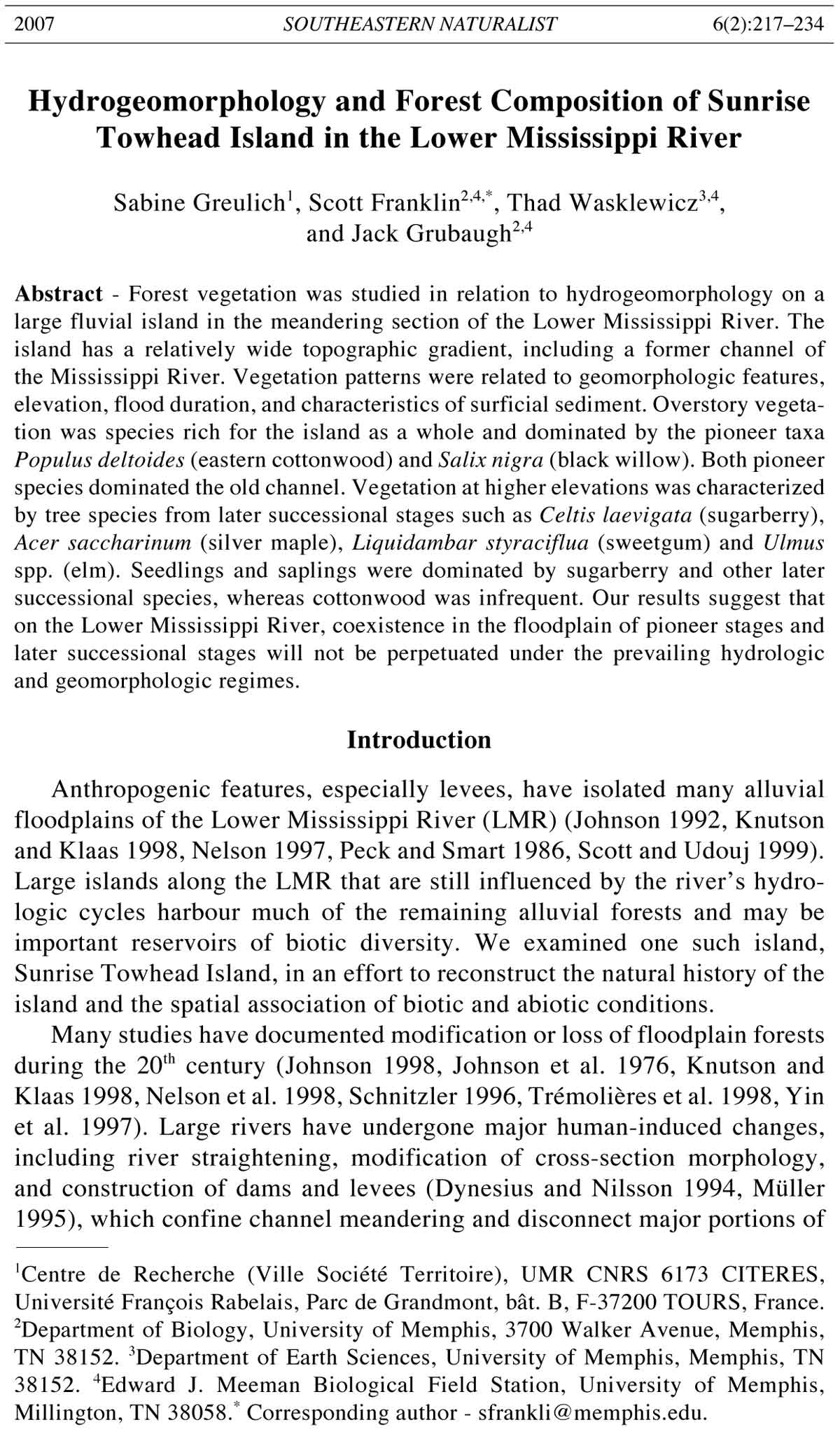
Sunrise Towhead Island is situated at Mississippi River mile 775,
approximately 40 km upstream from Memphis, TN, and just upstream
from the mouth of the Hatchie River (Fig. 1). At low flows of the Mississippi
River, the island measures approximately 6050 m long and 3000 m
wide, with an elevation range of 10 m (Fig. 1). Sunrise Towhead was
initiated as a point bar that was progressively cut (we think naturally)
from the shore during the 1930s and 1940s (Fig. 2a). Judging from several
years of aerial photography, a large portion of the western section of the
island was formed from deposition in the former main channel during
cutting of the bar, and by the successive abandonment of the old channel
(Fig. 2b). The old channel and other low areas of the island are still
connected to the river hydrology due to porosity of island geology. Thus,
during medium river stages (e.g., 8–10 m), while the island may not be
overtopped by high water, low areas in the island are inundated. Erosion
of the east shore by lateral migration of the Mississippi River main
2007 S. Greulich, S. Franklin, T. Wasklewicz, and J. Grubaugh 219
channel was abated by rip-rap and articulated concrete mattresses (i.e.,
revetments) that were laid out along the shore in the 1950s (Wasklewicz et
al. 2004). Mean annual low stages occur in fall and mean annual high
stages in late spring and early summer (Fig. 3), showing a flow pattern
Figure 1. Topographic map of Sunrise Towhead Island (Lower Mississippi River, TN).
220 Southeastern Naturalist Vol. 6, No. 2
Figure 2. Present and former position of Sunrise Towhead Island (Lower Mississippi
River, TN) with regard to the Mississippi River channels. The localization of sampling
transects is indicated by dashed (1937) or solid (1983) lines.
Figure 3. Hydrology (stage data standardized to meters NVGD 1929) for the Fulton,
TN, gauge from 1981 to 1989. Crosses denote the mean (horizontal line) and standard
deviation (vertical line) for the four major dominance types described on the island
(see Table 3), as well as the total elevation range studied on Sunrise Towhead Island.
2007 S. Greulich, S. Franklin, T. Wasklewicz, and J. Grubaugh 221
typical of southeastern coastal plain rivers (Hupp 2000). The island is
situated on a section of the Mississippi River where the channel bed has
been degrading since the 1930s, following artificial meander cut-offs further
downstream (Smith and Winkley 1996, Winkley 1994). The closest
gauging station is Fulton, 500 m upstream of Sunrise Towhead Island.
Methods
General abiotic factors
Two transects were established in 1999, crossing the island perpendicular
to river flow, approximately at 1/3 (close to the largest island width) and
2/3 of the island length (Fig. 2a). Both transects intersect the 1930s channel
and the higher elevations of the island core. Forest plots were established on
each transect at 80-m intervals. A total of 61 plots were established. Elevations
of the highest and lowest plots were 76.2 m and 67.1 m, respectively.
A sediment core sample of the upper 5 cm was extracted at the center of
each plot. Sediments were analyzed for organic matter content by loss
through ignition at 430 °C for 24 h, after having been oven dried overnight at
105 °C. The sediment fraction < 2 mm was separated by sieving and its
particle size distribution (fractions of sand, clay, and silt) was evaluated by
the hydrometer method (Foth et al. 1980).
Flooding frequency (number of times a particular site was inundated
each year) and duration (number of days of inundation per year) at the
different sampling plots were estimated by comparing topographic elevation
of the plots according to a 1:24,500 map (Osceola quadrangle, US Army
Engineer District Memphis, TN, 1994) and river-stage records from 1980 to
1989 (records after this point are not available) at the Fulton gauge. Elevation
data were obtained after mapping topography at a 1.5-m scale in GIS
software and overlaying plot points. Stage records were acquired from the
US Army Corps of Engineers, Memphis District.
Vegetation-environment relationships
Vegetation data were collected from each plot along the two transects.
Vegetation sampling was accomplished using the point-centered quarter
method (Mueller-Dombois and Ellenberg 1974). Within each quarter and
within 20 m, the nearest stem > 10 cm diameter at breast height (dbh) was
measured both for distance from plot center and for diameter, from which
basal area and density were calculated. At each of the four cardinal directions,
a 4-m radius circular plot (0.005 ha; all four = 0.02 ha for each site)
was established. Within these nested plots, all woody stems of trees and
shrub species were identified to species and counted as either saplings (dbh
2.54 and < 10 cm) or seedlings (dbh < 2.54 cm).
Data analysis
Relative frequency (number of plots per species/total number of plots),
relative dominance (basal area of species/total basal area), relative density
(individuals of species/total individuals), and importance value (I.V. = sum
222 Southeastern Naturalist Vol. 6, No. 2
of relative density and relative basal area) were calculated for each species
for all sample points. Environmental structure of sample plots was analysed
through a normalized principal component analysis (nPCA). Plots were
characterized by environmental variables, elevation (elev), average event
flooding duration between 1980 and 1989 (flood), percentage of clay (clay),
silt (silt), and sand (sand), percentage of organic matter (OM), distance from
channel in 1937 (dist_old), and closest distance to one of the two present
channels, west or east shore (dist_new). The latter variable was included
because island margins may be subjected to the most intense flood disturbance,
and may trap the highest amount of water-dispersed seeds. Both
factors could potentially influence vegetation patterns.
Overstory vegetation composition was analyzed by correspondence
analysis (CA). As a result of the point-centered method in vegetation sampling,
the score of each tree species at a sampling plot was assigned values
between 0 (i.e., none of the nearest trees belonged to the considered species)
and 4 (i.e., each of the four sampled trees on the plots belonged to the
considered species). Groups delineated through ordination analysis were
used as community types to document vegetation-environment relationships.
Ordination by environmental factors and ordination of overstory
vegetation were compared by co-inertia analysis (Dolédec and Chessel
1994). Statistical significance of the co-structure was tested with a random
permutation test (Monte Carlo test). All multivariate analyses were undertaken
using the ADE-4 software package (Thioulouse et al. 1997).
Results
General abiotic factors
Mean flooding frequency ranged from 0 at the highest elevation (76 m) to
50 times per year on the lowest elevation (67 m). Mean number of flood days
ranged from 0 to 181 days per year. Surface sediment texture was mostly
silty clay or clay. Sand dominated in the most marginal plots on both
transects and in the western third of the north transect. Texture ranged as
follows: sand constituted 0% to 100%, silt 0% to 63%, and clay 0% to 68%
of surface sediment. Organic matter content ranged from 0.15% to 3.9%.
Average annual flooding was positively correlated with percent clay and
organic matter. Plots close to the former channel were situated at low
elevations and appeared to have low sand, but high clay and organic matter
content, and a relatively high basal area. Distance from the present channel
showed few correlations with other abiotic factors.
Vegetation and environment relations
A total of 23 tree species were encountered. Populus deltoides Bartram
ex Marsh (eastern cottonwood) was the dominant species, representing half
of the total basal area (Table 1), followed by Salix nigra Marsh (black
willow) and Celtis laevigata Willd (sugarberry), which were similar in
density and frequency. Relative frequencies of the most dominant species
were similar on both transects.
2007 S. Greulich, S. Franklin, T. Wasklewicz, and J. Grubaugh 223
Ordination of sampling plots by correspondence analysis of overstory
vegetation revealed a direct gradient, with three main vegetation communities
coinciding with topography (Figs. 4 and 5). Co-inertia between
overstory vegetation structure and environmental factors was highly significant
(p < 0.0001; Fig. 4). Group A, the Ulmus-Celtis laevigata community
based on dominance (Table 2), comprised species centered far from the old
channel, on unflooded or only briefly flooded plots with sandy sediment
(Table 3). The canopy was generally sparse, with other dominant species
including Juniperus virginiana L. (eastern red cedar) and Diospyros
virginiana L. (common persimmon). The understory was dominated by
sugarberry and was more diverse (seedling richness = 5) than other communities
(seedling richness 3; Table 4).
Group B, the Celtis laevigata-Ulmus-Acer saccharinum community,
was composed of species that were generally located outside the old
channel at sites with intermediate annual flooding and intermediate to
fine-grained sediment, relatively far from the present river channels
(Table 3, Fig. 5). This group had fairly high richness for all strata,
especially the canopy (richness = 11), compared to other groups (canopy
richness 8; Tables 2 and 4).
Table 1. Overstory (trees > 10 cm dbh) composition on the Mississippi Island Sunrise Towhead.
N = total number of individuals on island; Rel. dom. = relative dominance; Rel. den. = relative
density; I.V. = importance value (= relative dominance + relative density); Plot Frequency =
number of plots in which a species occurs with regard to total plot number. Species are listed in
order by I.V.
Abbrev. Species Rel. Rel. % plot
name common name (scientific name) N dom. den. I.V. frequency
Popdel Eastern cottonwood (Populus deltoides) 43 50.0 21.4 71.4 37.7
Salnig Black willow (Salix nigra) 42 19.2 20.9 40.1 32.8
Cellae Southern hackberry (Celtis laevigata) 38 9.6 18.9 28.5 36.1
Ulmus1 Elm (Ulmus spp.) 23 7.7 11.5 19.1 26.2
Acesaci Silver maple (Acer saccharinum) 21 6.7 10.4 17.2 21.3
Aceneg Boxelder (Acer negundo) 7 1.8 3.5 5.3 11.5
Carya2 Hickory (Carya spp.) 6 1.2 3.0 4.2 9.8
Gletri Honey locust (Gleditsia triacanthos L.) 2 1.4 1.0 2.4 3.3
Junvir Eastern red cedar (Juniperus virginiana) 3 0.8 1.5 2.3 4.9
Diovir Common persimmon (Diospyros virginiana) 4 0.3 2.0 2.3 4.9
Liqsty Sweetgum (Liquidambar styraciflua) 3 0.2 1.5 1.7 1.6
Quenig Water Oak (Quercus nigra L.) 2 0.2 1.0 1.2 1.6
Iledec Possumhaw holly (Ilex decidua)Walter 2 0.1 1.0 1.1 3.3
Frapen Ash (Fraxinus pennsylvanica Marsh.) 1 0.6 0.5 1.1 1.6
Betnig River birch (Betula nigra L.) 1 0.1 0.5 0.6 1.6
Nyssyl Sourgum (Nyssa sylvatica L.) 1 0.1 0.5 0.6 1.6
Morrub Red mulberry (Morus rubra L.) 1 0.1 0.5 0.6 1.6
Malus Crabapple (Malus sp.) 1 0.0 0.5 0.5 1.6
Totals 201 100.0 100.0 200.0 100.0
1Ulmus species included Ulmus rubra Muhl (slippery elm), Ulmus americana L.(American
elm), and Ulmus alata Michx (winged elm).
2Carya species included Carya illinoensis (Wangenh) K. Koch (pecan) (CARILL), Carya
laciniosa (Michx.) Loudon (shellbark hickory) (CARLAC), and Carya tomentosa (Poir.) Nutt
(mockernut hickory) (CARTOM).
224 Southeastern Naturalist Vol. 6, No. 2
Group C, dominated by eastern cottonwood and black willow, was located
on parts of the island with the greatest annual flooding and was the dominant
community (31 of 61 plots). This group was common in the old channel, where
soils were fine-textured and soil organic matter content fairly high.
A fourth group, lacking an overstory, was dominated by Prunus
angustifolia Marsh (chickasaw plum) shrubs at higher elevations on sandy,
droughty soils with very low organic matter (Tables 3 and 4, Fig. 5).
Eastern red cedar and Ulmus spp. were the only taxa found taller than 1.5
m, and individuals were scarce. Cornus drummondii C.A. Mey (roughleaf
dogwood) was also common in these sites. Flooding was infrequent and of
short duration.
Figure 4. Factorial maps of overstory vegetation (a) and abiotic factors (b) on Sunrise
Towhead Island, Lower Mississippi River, TN. Maps were created by co-inertia
analysis that linked ordination of sampling plots according to vegetation to their
ordination according to abiotic factors. Species are abbreviated by the first three
letters of their generic name and specific epithet (see Table 1). See text for explanation
of abiotic factors.
2007 S. Greulich, S. Franklin, T. Wasklewicz, and J. Grubaugh 225
Dominant tree species showed different patterns throughout the island
with regard to size-class distribution (Fig. 6). In all species but eastern
cottonwood, tree abundance was greatest in the smallest size classes,
Figure 5. Vegetation communities (based on ordination analysis) along sampling
transects on Sunrise Towhead Island, Lower Mississippi River, TN. The channel
prior to island formations (i.e., old channel) is shown for both transects. Elevation is
meters above mean sea level. S = surface sediments with > 50% sand.
226 Southeastern Naturalist Vol. 6, No. 2
reflecting recruitment subsequent to overstory formation. The great majority
of eastern cottonwood trunks were larger than 40 cm dbh, while the
smallest size class was absent. The largest trees on the island were eastern
cottonwood and black willow.
The major portion of small understory vegetation (stems < 2.54 cm dbh)
consisted of the shrub or vine Toxicodendron radicans L. Kuntze (poison
ivy; Table 4). Sugarberry was the most frequent and most abundant species
of tree seedlings and saplings, followed by Acer negundo L. (boxelder) and
silver maple in the seedling size class, and by black willow in the sapling
size class. Eastern cottonwood, the dominant overstory species, was infrequent
in the understory.
Table 3. Mean (± standard deviation) values of various environmental variables of the four
major dominance types on Sunrise Towhead Island, Lower Mississippi River. Flood frequency
is the average number of times a particular site was inundated. Flood duration is the number of
days a particular site remained inundated. Soil texture and organic matter are from the top 10 cm
of soil profile.
Celtis laevigata-
Prunus Ulmus-Celtis Ulmus-Acer Populus deltoides-
Variable shrubland laevigata saccharinum Salix nigra
Elevation (m) 73.9 (0.8) 73.5 (1.3) 71.9 (2.3) 68.9 (1.7)
Flood duration (days) 12 (7.1) 17 (14) 45 (45.5) 112 (44.9)
Flood frequency < 1 5 (3.9) 12 (12.5) 31 (12.3)
Percent organic matter 0.2 (0.1) 1.4 (1.1) 2.3 (1.1) 2.5 (0.7)
Percent clay 1 (2.5) 21 (19.2) 38 (21.9) 45 (16.8)
Percent sand 96 (5.7) 57 (38.5) 28 (38.5) 11 (25.7)
Distance to old channel (m) 1467 (141) 1020 (484) 286 (353) 111 (216)
Distance to new channel (m) 360 (150) 816 (491) 678 (421) 590 (330)
Table 2. Relative basal area for select species of the four major dominance types on Sunrise
Towhead Island, Lower Mississippi River. All Prunus stems were < 10 cm diameter at breast
height, and thus had negligible basal area.
Celtis laevigata-
Prunus Ulmus- Ulmus-Acer Populus deltoides-
Species shrubland Celtis laevigata saccharinum Salix nigra
Juniperus virginiana 60.0 8.4
Diospyros virginiana 3.5 0.1
Celtis laevigata 19.2 32.4 3.1
Other hardwoods 9.3 6.0 0.8
Liquidambar styraciflua 2.3
Ulmus spp. 40.0 46.4 26.1
Acer saccharinum 19.1 4.4
Acer negundo 9.0 0.2
Populus deltoides 5.0 66.1
Salix nigra 2.4 25.4
Sample size (number of sites) 6 5 19 31
Total richness (all sites) 2 8 11 7
Average basal area (4 stems) 0.03 0.35 0.23 0.58
2007 S. Greulich, S. Franklin, T. Wasklewicz, and J. Grubaugh 227
Discussion
We found evidence for one major environmental gradient controlling
vegetation patterns on Sunrise Towhead Island. As with most floodplain
systems, vegetation was strongly related to inundation and associated soil
characteristics, e.g., soil texture (Johnson et al. 1995, Mitsch and Gosselink
1993). This study shows that pioneer tree species eastern cottonwood and
black willow presently dominate the forest canopy on Sunrise Towhead
Island, but succession is proceeding toward more shade tolerant hardwoods,
e.g., sugarberry.
Sunrise Towhead Island, situated in the Lower Mississippi Valley
(LMV), belongs to the southern floodplain forest region (Küchler 1964).
This region covers the Mississippi alluvial plain northward from the Gulf
Coast to the southern tip of Illinois, and along the lower reaches of several
Mississippi tributaries (Braun 1950, Putnam et al. 1960). We found four
major vegetation-environment zones on the island.
The lowest, most frequently flooded parts of the island were characterized
by fine-grained sediments (silty clay, clay). Their very low organic
matter content (< 3.5%) suggests that those sediments had been deposited by
recent low-energy flows such as waning floods and had not yet been
amended in situ by organic material (Hupp 2000). The soil and flood characteristics
seem to match floodplain zone III as described by Clark and
Benforado (1981) and Wharton et al. (1982). Canopy dominants were eastern
cottonwood and black willow, matching most closely to the P. deltoides
Temporarily Flooded Forest Alliance (I.B.2.N.d.160) of The Nature
Conservancy’s (TNC) National Vegetation Classification System (NVCS,
Table 4. Total sapling (2.54 < dbh < 10 cm) density, average sapling density in parentheses, and
diversity for the four major dominance types on Sunrise Towhead Island, Lower Mississippi River.
Celtis laevigata-
Prunus Ulmus- Ulmus-Acer Populus deltoides-
Species shrubland Celtis laevigata saccharinum Salix nigra
Cornus drummundii 23 (4) 18 (4) 32 (2) 1 (< 1)
Prunus angustifolia Marsh. 14 (2) 7 (1) 0 1 (< 1)
Juniperus virginiana 7 (1) 0 1 (1) 1 (< 1)
Diospyros virginiana 0 7 (1) 2 (less than 1) 7 (< 1)
Celtis laevigata 1 79 (16) 104 (6) 14 (1)
Ulmus spp. 0 5 (< 1) 14 (1) 1 (< 1)
Other hardwoods 0 31 (6) 45 (3) 20 (1)
Toxicodendron radicansA 3 474 (95) 5233 (275) 302 (10)
Acer negundo 0 1 (< 1) 3 (< 1) 26 (1)
Populus deltoides 0 0 6 (< 1) 2 (< 1)
Salix nigra 0 0 27 (2) 378 (12)
Mean seedling richness 2 5 3 2
Mean seedling evenness 0.22 0.68 0.35 0.33
Mean sapling richness 2 3 3 1
Mean sapling evenness 0.42 0.76 0.53 0.18
ASeedlings, shown due to overwhelming dominance.
228 Southeastern Naturalist Vol. 6, No. 2
Figure 6.
Size distribution
of the
five most
dominant
tree species
on
S u n r i s e
Towhead
I s l a n d ,
L o w e r
M i s s i s -
s i p p i
R i v e r ,
TN.
2007 S. Greulich, S. Franklin, T. Wasklewicz, and J. Grubaugh 229
sensu Weakley et al. 1998). Lack of eastern cottonwood regeneration and
predominance of smaller black willow suggests more frequent inundation at
present than during the initial formation of the forest (Fralish and Franklin
2002). Compared to eastern cottonwood seedlings, seedlings of black willow
are more tolerant to saturated soil conditions and long inundation
(Hosner and Minckler 1963, Shelford 1954).
Intermediate elevations and flooding regimes of the island matched
with floodplain zone IV (Clark and Benforado 1981, Wharton et al. 1982),
and were dominated by sugarberry and Ulmus species. Ulmus dominated
on higher elevations with lower organic matter and higher percentages of
sand, while sugarberry and Ulmus spp. shared dominance with silver
maple and several other hardwood species at elevations between Ulmusdominated
communities and Populus-dominated communities. These
communities are most similar to the Sugarberry-Elm-Ash cover type developed
by the Society of American Foresters (Eyre 1980), and the Acer
saccharinum Temporarily Flooded Forest Alliance from TNC’s NVCS
(Weakley et al. 1998).
These Celtis-dominated forests are currently the most common community
of the Mississippi Alluvial Valley (McWilliams and Rosson 1990),
almost doubling in size since the 1930s (Rudis 2001). They now exhibit the
strongest successional trend on the island, with large eastern cottonwood
and black willow stems in the overstory and few to none in the understory.
This successional sequence is common of southern floodplain forests, where
seral communities following cottonwood-willow stands are typically dominated
by Liquidambar styraciflua L. (sweetgum), sugar berry, and/or silver
maple (Barnes 1985, Hosner and Minckler 1963, Putnam et al. 1960,
Shelford 1954).
Available aerial photographs suggest that cottonwood was established in
the early 1950s, i.e., soon after the old channel was abandoned by the
Mississippi River in the 1940s. Estimated age and location of the present
cottonwood-willow stands suggest that they comprise the first colonizers of
the old Mississippi channel (mainly willow) and adjacent sand bars (mainly
cottonwood), ideal conditions for cottonwood-willow colonization (Fralish
and Franklin 2002, Karrenberg et al. 2003, Kellison et al. 1998, Shull 1944).
According to Shelford’s (1954) schedule of community development in the
Lower Mississippi floodplain, the dominance of the Celtis-Liquidambar
stage is achieved about 80 years after establishment of the first cottonwoodwillow
seedlings. Our findings suggest that vegetation succession on Sunrise
Towhead will support this timeframe.
These seral communities (sugarberry is short-lived, < 150 years) may
eventually be succeeded by an oak-hickory forest type, which would be
determined by a combination of site conditions and disturbance regimes
(Sharitz and Mitsch 1993, Shelford 1954). Later successional oak (mainly
Quercus nigra L. [WATER OAK]) and hickory species (mainly pecan),
while currently present, make up a small percentage of the overstory vegetation
(a combined importance value of only 5.4).
230 Southeastern Naturalist Vol. 6, No. 2
The above-described vegetation and succession gradient explains why
species richness on Sunrise Towhead is relatively high compared to findings
from other studies on floodplain forests. We identified 23 overstory tree taxa
(17 genera), and some additional species were encountered in the seedling/
sapling layer. The surveyed surface, however, was small (7.7 ha: 61 plots of
0.126 ha). Since the point-quarter centered method takes only four trees at
each sampling plot into account, additional species may occur on the island.
As a comparison, Johnson et al. (1976) studied 34 floodplain forest stands
along a 130-km stretch of the Missouri River and found nine overstory
species. Crites and Binger (1969) encountered 12 tree species in six floodplain
forests in east-central Illinois. Knutson and Klaas (1998) conducted a
floristic inventory of floodplain forests along the Upper Mississippi River
(pools 6 to 10, a river stretch of 177 km) and listed 18 overstory species, a
number similar to that found on Sunrise Towhead. Studies that were able to
sample southern bottomland forest on wider topographic gradients and/or
to include later successional stages have found a species richness exceeding
that of Sunrise Towhead. Shelford (1954), in the Lower Mississippi River,
and Robertson et al. (1978), in the Middle Mississippi River, for example,
list some forty tree species each.
Surface sediment of many of the highest, least flooded sites were mainly
sand (88% to 100%) and had very low organic matter content (“no overstory”
zone). This zone was occupied mainly by Prunus angustifolia
(chickasan plum) shrubs, a drought-tolerant species that commonly grows in
thickets on sandy soils (Gilman and Watson 1994). This differs from what
one would expect underlaying undisturbed, later successional communities,
and has no clear counterpart in typical floodplains. Scattered stems of
eastern red cedar and common persimmon occurred in these xeric conditions.
According to the Mississippi River hydrograph (Fulton gauge) of the
recent past, the highest zone of the island is rarely flooded, and the vegetation
exists mainly because of rainwater. There are two possible explanations
for the origin of the sandy soil. First, these high elevation sands may have
been deposited during major events (1927, 1937, and 1980 according to
Fulton gauge records) and thus are above high-water levels of normal years.
Secondly, sands may have been dumped on the island as dredge spoil,
although dredge spoil along this section of the Mississippi River is almost
always dumped back into the river to be carried downstream (Micheal
Thron, US Army Corps of Engineers, Memphis District, Memphis, TN, pers.
comm.). In addition, historical maps show this portion of the island intact
back to the 1800s.
This study shows that the hydrologic and geomorphologic context of
Sunrise Towhead Island excludes development of new habitats for pioneer
vegetation on the island. It is unlikely that this situation will change in the
near future, since meandering of the river and erosion of the island shore
will not continue to generate moist, open sandy surfaces ideal for pioneer
seed germination due to rip-rap and articulated concrete mattresses. These
2007 S. Greulich, S. Franklin, T. Wasklewicz, and J. Grubaugh 231
engineered features are part of the regulation of the Mississippi River that
started systematically on a large scale in the 1930s (Stevens et al. 1975,
Theiling 1999, Wasklewicz et. al. 2001, Winkley 1994).
Since Sunrise Towhead has assembled on its small surface ecological
gradients typical of floodplain environments, the island might be representative
of the whole floodplain sector. Our results suggest that on the Lower
Mississippi River, the coexistence in the floodplain of pioneer stages and
later successional stages that is valuable from a landscape diversity point
of view (Amoros and Bornette 2002, Naiman et al. 1993, Osterkamp et al.
2001, Schnitzler 1996, Ward 1998, Ward et al. 1999) will not be perpetuated
under the prevailing hydrologic and geomorphologic regimes. With
the area of floodplain forests in the Mississippi Alluvial Plain steadily
declining over the past 70 years (McWilliams and Rosson 1990), islands
may be important diversity refuges, and should be incorporated into restoration
proposals for the Lower Mississippi River (Llewellyn et al. 1996,
Stanturf et al. 2000).
Acknowledgments
The authors are grateful to Darren Mitchell, Dennis Staley, Marcus Pearson, and
Timothy Bills. Thanks to A. Schnitzler and K. Maier for sharing knowledge on
southern floodplain forests, and K. Maier for field help. A special thanks to D. Marsh
and T. Welch for allowing us to overnight on the island. This research was made
possible by a post-doctoral grant of the University of Memphis’ Biology Department
to S. Greulich, and by an internal University of Memphis Faculty Research Grant.
The research would not have been possible without the support of the Meeman
Biological Field Station (MBFS). MBFS supplied use of field equipment, materials,
and boat travel to and from the island.
Literature Cited
Amoros, C., and G. Bornette. 2002. Connectivity and biocomplexity in waterbodies of
riverine floodplains. Freshwater Biology 47:761–776.
Barnes, W.J. 1985. Population dynamics of woody plants on a river island. Canadian
Journal of Botany 63:647–655.
Bayard, M., and F.H. Schweingruber. 1991. Ein baumgrenzstandort: Das
Wildwasserbett der Maggia im Tessin, Schweiz. Eine dendroökologische studie.
Botanica Helvetica 101:9–28.
Braun, E.L. 1950. Deciduous Forests of Eastern North America. The Blakiston
Company, Philadelphia, PA.
Clark, J.R., and J. Benforado (Eds.) 1981. Wetlands of Bottomland Hardwood Forests.
Elsevier, Amsterdam, The Netherlands.
Crites, R.W., and J.E. Binger. 1969. Vegetation survey of floodplain forests in East
Central Illinois. Transactions Illinois Academy Science 44:316–330.
Delaney, R., and M.R. Craig. 1997. Longitudinal changes in Mississippi River floodplain
structure. Upper Mississippi River Long Term Resource monitoring Program,
US Geological Survey, Onalaska, WI. Project Status Report 97-02.
Dolédec, S., and D. Chessel. 1994. Co-inertia analysis: An alternative method for
studying species-environment relationships. Freshwater Biology 31:277–294.
232 Southeastern Naturalist Vol. 6, No. 2
Dykaar, B.B., and P.J. Wigington. 2000. Floodplain formation and cottonwood colonization
patterns on the Willamette River, Oregon, USA. Environmental Management
25:87–104.
Dynesius, M., and C. Nilsson. 1994. Fragmentation and flow regulation of river
systems in the northern third of the world. Science 266:753–762.
Eyre, F.H. 1980. Forest-cover Types of the United States and Canada. Society of
American Foresters, Washington, DC.
Foth, H.D., L.V. Withee, H.S. Jacobs, and S.J. Thien. 1980. Laboratory Manual for
Introductory Soil Science, 5th Edition. WCB Publishing, Dubuque, IA.
Fralish, J.S., and S.B. Franklin. 2002. Taxonomy and Ecology of Woody Plants in
North American Forests. John Wiley and Sons, Inc., New York, NY.
Franklin, S.B., T. Wasklewicz, J.W. Grubaugh, and S. Gruelich. 2003. Temporal
periodicity of the Mississippi River before and after systematic channel modifications.
Journal of the American Water Resources Association 39:637–648.
Galay, V.J. 1983. Causes of river bed degradation. Water Resources Research
19:1057–1090.
Gilman, E.F., and D.G. Watson. 1994. Prunus angustifolia, Chickasaw Plum. US
Forest Service Fact Sheet ST-504, Florida Cooperative Extension Service, University
of Florida, Gainesville, FL.
Grubaugh, J.W., and R.V. Anderson. 1989. Long-term effects of navigation dams on a
segment of the upper Mississippi River. Regulated Rivers: Research and Management
4:97–104.
Gurnell A.M., and G.E. Petts. 2002. Island-dominated landscapes of large floodplain
rivers, a European perspective. Freshwater Biology 47:581–600.
Hosner, J.F., and L.S. Minckler. 1963. Bottomland hardwood forests of Southern
Illinois: Regeneration and succession. Ecology 44:29–40.
Hupp, C.P. 2000. Hydrology, geomorphology, and vegetation of coastal plain rivers in
the southeastern United States. Hydrologic Processes 14:2991–3010.
Johnson, W.C. 1992. Dams and riparian forest: Case study from the Upper Missouri
River. Rivers 3:229–242.
Johnson, W.C. 1998. Adjustment of riparian vegetation to river regulation in the Great
Plains, USA. Wetlands 18 (4): 608–618.
Johnson, W.C., R.L. Burgess, and W.R. Kaemmerer. 1976. Forest overstory vegetation
and environment on the Missouri River Floodplain in North Dakota. Ecological
Monographs 46:59–84.
Johnson, W.C., M. Dixon, R. Simons, S. Jenson, and K. Larson. 1995. Mapping the
response of riparian vegetation to possible flow reductions in the Snake River,
Idaho. Geomorphology 13:159–173.
Karrenberg, S., P.J. Edwards, and J. Kollmann. 2003. The life history of Salicaceae
living in the active zone of floodplains. Freshwater Biology 47:733–748.
Kellison, R.C., M.J. Young, R.R. Braham, and E.J. Jones. 1998. Major alluvial
floodplains. Pp. 219–323, In M.G. Messina and W.H. Conner (Eds.). Southern
Forested Wetlands Ecology and Management, Lewis Publishers, Boca Raton, FL.
Knutson, M.G., and E.E. Klaas.1998. Floodplain forest loss and changes in forest
community structure in the Upper Mississippi River: A wildlife habitat at risk.
Natural Areas Journal 18:138–150.
Kollmann, J., M. Vieli, P.J. Edwards., K. Trockner, and J.V. Ward. 1999. Interactions
between vegetation development and island formation in the Alpine river
Tagliamento. Applied Vegetation Science 2:25–36.
Küchler, A.W. 1964. Manual to Accompany the Map of Potential Vegetation of the
Conterminous United States. Special Publication No. 36. American Geographical
Society, New York, NY.
2007 S. Greulich, S. Franklin, T. Wasklewicz, and J. Grubaugh 233
Lekarczyk, M. 2003. Island morphometry: 55 years of change on the northern lower
Mississippi. M.Sc. Thesis. University of Memphis, Memphis, TN.
Llewellyn, D.W., G.P. Shaffer, N.J. Craig, L. Creasman, D. Pashley, M. Swan, and C.
Brown. 1996. A decision-support system for prioritizing restoration sites on the
Mississippi River. Conservation Biology 10:1446–1455.
McWilliams, W.H., and J.F. Rosson, Jr. 1990. Composition and vulnerability of
bottomland hardwood forests of the Coastal Plain Province in the south central
United States. Forest Ecology and Management 33/34:485–501.
Merigliano, M.F. 1998. Cottonwood and willow demography on a young island,
Salmon River, Idaho. Wetlands 18:571–576.
Merritt, D.M., and D.J. Cooper. 2000. Riparian vegetation and channel change in
response to river regulation: A comparative study of regulated and unregulated
streams in the Green River Basin, USA. Regulated Rivers: Research and Management
16:543–564.
Mitsch, W.J., and J.G. Gosselink. 1993. Wetlands, 2nd Edition. John Wiley and Sons,
Inc., New York, NY.
Mueller-Dombois, D., and H. Ellenberg. 1974. Aims and Methods of Vegetation
Analysis. John Wiley and Sons, New York, NY.
Müller, N. 1995. River dynamics and floodplain vegetation and their alterations due to
human impact. Archiv für Hydrobiologie Supplement 101:43–61.
Naiman, R.J., H. Décamps, and M. Pollock. 1993. The role of riparian corridors in
maintaining regional biodiversity. Ecological Applications 3:209–212.
Nelson, J.C. 1997. Presettlement vegetation patterns along the 5th principal meridian,
Missouri Territory, 1815. American Midland Naturalist 137:79–94.
Nelson, J.C., L. DeHaan, R.E. Sparks, and L. Robinson. 1998. Presettlement and
contemporary vegetation patterns along two navigation reaches of the Upper
Mississippi River. Pp. 51–60, In T.D. Sisks (Ed.). Perspectives on the Land Use of
North America: A Context for Understanding Our Changing Environment. US
Geological Survey, Biological Resources Division, Springfield, VA. Biological
Science Report USGS/BRD/BSR 1998-003 (Revised September 1999).
Osterkamp W.R. 1998. Processes of fluvial island formation, with examples from
Plum Creek, Colorado and Snake River, Idaho. Wetlands 18:530–545.
Osterkamp, W.R., W.C. Johnson, and M.D. Dixon. 2001. Biophysical gradients
related to channel islands, Middle Snake River, Idaho. Pp. 73–83, In J.M Dorava,
D.R. Montgomery, B.B. Palcsak, and F.A. Fitzpatrick (Eds.). Geomorphic Processes
and Riverine Habitats, Water Science and Application Volume 4. American
Geophysical Union, Washington, DC.
Peck, J.H., and M.M. Smart. 1986. An assessment of the aquatic and wetland vegetation
of the Upper Mississippi River. Hydrobiologia 136:57–76.
Poff, N.L., J.D. Allan, M.B. Bain, J.R. Karr, K.L. Prestegaard, B.D. Richter, R.E.
Sparks, and J.C. Stromberg. 1997. The natural flow regime. BioScience 47:764–784.
Putnam, J.A., G.M. Furnival, and J.S. McKnight. 1960. Management and inventory of
southern hardwoods. Agriculture Handbook 181. US Department of Agriculture
Forest Service, Washington, DC.
Robertson, P.A., G.T. Weaver, and J.A. Cavanaugh. 1978. Vegetation and tree species
patterns near the northern terminus of the southern floodplain forest. Ecological
Monographs 48:249–267.
Rudis, V.A. 2001. Composition, potential old growth, fragmentation, and ownership
of Mississippi Alluvial Valley bottomland hardwoods: A regional assessment of
historic change. Pp. 28–48, In P.B. Hamel and T.L. Foti (Eds.). Bottomland
Hardwoods of the Mississippi Alluvial Valley: Characteristics and Management of
Natural Function, Structure, and Composition. General Technical Report SRS-42.
USDA Forest Service, Asheville, NC.
234 Southeastern Naturalist Vol. 6, No. 2
Schnitzler, A. 1996. Comparison of landscape diversity in forests of the upper Rhine
and middle Loire floodplains (France). Biodiversity and Conservation. 5:743–758.
Scott, H.D., and T.H. Udouj. 1999. Spatial and temporal characterization of land use in
the Buffalo National River Watershed. Environmental Conservation 26:94–101.
Sharitz, R.R., and W.J. Mitsch. 1993. Southern floodplain forests. Pp. 311–372, In
W.H. Martin, S.G. Boyce, and A.C. Echternacht (Eds.). Biodiversity of the Southeastern
United States: Lowland Terrestrial Communities. John Wiley and Sons,
New York, NY.
Shelford, V.E. 1954 Lower Mississippi valley flood plain biotic communities: Their
age and elevation. Ecology 35:126–142.
Shull, C.A. 1944. Observations of general vegetation changes on a river island in the
Mississippi River. American Midland Naturalist 32:771–776.
Smith, L.M., and Winkley, B.R. 1996. The response of the lower Mississippi River to
river engineering. Engineering Geology 45:433–455.
Sparks, R.E. 1995. Need for ecosystem management of large rivers and their floodplains.
BioScience 45:168–182.
Stanturf, J.A., E.S. Gardiner, P.B. Hamel, M.S. Devall, T.D. Leininger, and M.E.
Warren, Jr. 2000. Restorating bottomland hardwood ecosystems in the lower
Mississippi Alluvial Valley. Journal of Forestry 98:10–16.
Stevens, M.A., Simons, D.B., and Schumm, S.A. 1975. Man-induced changes of
Middle Mississippi River. Journal of the Waterways Harbors and Coastal Engineering
Division 101:119–133.
Theiling, C. 1999. Important milestones in the human and ecological history of the
Upper Mississippi River system. Pp. 3–1 to 3–12, In J.D. Cox and M.V. Winger
(Eds.). Ecological Status and Trends of the Upper Mississippi River System 1998.
LTRMP Report 99-T001. US Geological Survey, La Crosse, WI.
Thioulouse, J., D. Chessel, S. Dolédec, and J.M. Olivier. 1997. ADE-4: A multivariate
analysis and graphical display software. Statistics and Computing 7:75–83.
Trémolières, M., J.M. Sanchez-Pérez, A. Schnitzler, and D. Schmitt. 1998. Impact of
river management history on the community structure, species composition, and
nutrient state in the Rhine alluvial forest. Plant Ecology 135:59–78.
Ward, J.V. 1998. Riverine landscapes: Biodiversity patterns, disturbance regimes, and
aquatic conservation. Biological Conservation 83:269–278.
Ward, J.V., K. Tockner, and F. Schiemer. 1999. Biodiversity of floodplain river
ecosystems: Ecotones and connectivity. Regulated Rivers: Research and Management
15:125–139.
Wasklewicz, T.A., S.B. Franklin, S. Greulich, and J.W. Grubaugh. 2001. Changes in
the hydrologic periodicity of Mississippi River, USA. Pp. 53–61, In R.A. Falconer
and W.R. Blain (Eds.). River Basin Management, WIT Press, Southampton, UK.
Wasklewicz, T.A., J.W. Grubaugh, S.B. Franklin, and S. Gruelich. 2004. 20th-century
trends along the Mississippi River. Physical Geography 25:208–224.
Weakley, A.S., K.D. Patterson, S. Landaal, M. Pyne, and others. 1998. Terrestrial
Vegetation of the Southeastern United States. March 1998 working draft. The
Nature Conservancy, Chapel Hill, NC.
Wharton, C.H., W.M. Kitchens, E.C. Pendleton, and T.W. Sipe. 1982. The ecology of
bottomland hardwood swamps of the southeast: A community Profile. FWS/OBS-
81/37. US Fish and Wildlife Service, Biological Service Program, Washington, DC.
Winkley, B.R. 1994. Response of the lower Mississippi River to flood control and
navigation improvements. Pp. 45–74, In S.A. Schumm and B.R. Winkley (Eds.).
The Variability of Large Alluvial Rivers. American Society of Civil Engineers,
New York, NY.
Yin, Y., J.C. Nelson, and K.S. Lubinski. 1997. Bottomland hardwood forests along the
Upper Mississippi River. Natural Areas Journal 17:164–173.


 The Southeastern Naturalist is a peer-reviewed journal that covers all aspects of natural history within the southeastern United States. We welcome research articles, summary review papers, and observational notes.