2013 SOUTHEASTERN NATURALIST 12(1):41–60
A Range-wide Survey of the Endangered
Black-capped Vireo in Texas
Tiffany M. McFarland1,*, Heather A. Mathewson1, Julie E. Groce2,
Michael L. Morrison3, and R. Neal Wilkins1
Abstract - Vireo atricapilla (Black-capped Vireo) is an endangered migratory songbird
with a breeding range that exists predominantly within Texas. Despite the species’ listing
under the Endangered Species Act in 1987, Black-capped Vireos were largely undocumented
in much of the range. We sampled over 10,700 points in Texas, resulting in 2458
Black-capped Vireo detections. We examined the relationship between Black-capped
Vireo occurrence and vegetation and broad-scale landscape variables, and we assessed if
detections were clustered. Black-capped Vireo detections occurred often on a common
soil type but were found where slopes were higher in the western part of the range. We
found evidence of clustering in six of our eight study areas but no evidence of habitat
metrics driving that clustering. These data improve the current knowledge of Blackcapped
Vireo distribution and offer opportunities for improved guidance for conservation
and management efforts.
Introduction
Successful conservation and management practices require knowledge of
an animal’s distribution within its range so that the entirety of the population
is taken into account and efforts can be targeted to maximize their impact
(Colwell and Dodd 1995, Debinski and Brussard 1994, Kantrud and Stewart
1984, Wiens and Rotenberry 1985). This knowledge is especially important
for threatened and endangered species whose ranges might be fragmented or
limited to portions of their original extent. However, adequately estimating a
species’ distribution can be challenging for species whose range is primarily
located on private lands, where data might be limited. Distribution estimates
and management strategies for species occurring mainly on private properties
often must be extrapolated from habitat data collected at a few well-studied locations
(Miller et al. 2004).
Vireo atricapilla Woodhouse (Black-capped Vireo; hereafter “Vireo”) is
a migratory songbird with a known breeding range throughout portions of
central Texas, isolated areas in Oklahoma (Grzybowski 1986, Wilkins et al.
2006), and the states of Coahuila, Tamaulipas, and Nuevo Leon in Mexico
(Farquhar and Gonzalez 2005). In November 1987, the US Fish and Wildlife
Service (USFWS) listed the species as endangered under the Endangered Species
Act (ESA) due to habitat loss from development, habitat destruction from
1Institute of Renewable Natural Resources, Texas A&M University, College Station, TX
77843. 2Institute of Renewable Natural Resources, Texas A&M University, San Antonio,
TX 78215. 3Department of Wildlife and Fisheries Sciences, Texas A&M University,
College Station, TX 77843. *Corresponding author - tiffany.mcfarland@agnet.tamu.edu.
42 Southeastern Naturalist Vol. 12, No. 1
grazing livestock and exotic herbivores, and nest parasitism by the Molothrus
ater (Brown-headed Cowbird) (Ratzlaff 1987).
At the time of listing in 1987, approximately 350 adult Vireos were counted
from surveys in 33 sites across Texas (Marshall et al. 1985). In 2006, the documented
Vireo detections in the United States consisted of 6010 males, with
almost 80% of these concentrated on just four managed properties: Fort Hood
Military Reservation and Kerr Wildlife Management Area in Texas, and the
Wichita Mountains National Wildlife Refuge and Fort Sill Military Reservation,
which are adjacent, in Oklahoma (Wilkins et al. 2006). Knowledge of Vireo distribution
and abundance beyond these public properties is limited, as most of the
Vireo’s breeding range overlaps private lands and has not been surveyed (Juarez
2004, Magness 2003, Maresh and Rowell 2000, Wilkins et al. 2006). This lack
of quantitative information on the Vireo from across its range prevents a reliable
evaluation of the species’ habitat use and status and limits broad-scale planning
and implementation of management actions that would enhance conservation of
the species.
Breeding habitat for the Vireo in the US is composed of patches of low,
scrubby shrubs and trees that are primarily deciduous and of irregular height
with sufficient vegetative cover near the ground to protect the low nest (typically
placed about 1 m above ground; Graber 1961, Grzybowski 1995). However, habitat
can vary greatly in vegetation composition and other characteristics across
the range. The ability to map potential Vireo habitat across its breeding range,
and thus improve our knowledge of the species’ distribution, would first require
analyzing relationships between Vireo occurrence and environmental characteristics.
Unfortunately, quantifiable predictors of Vireo habitat—both those that
can be measured via remote-sensing and measurements that must be collected on
the ground—are largely unknown (Wilkins et al. 2006), and characteristics of the
understory are difficult to discern via remote-sensing techniques such as aerial
photography and satellite imagery.
As a potential complication for predicting Vireo distribution and habitat use,
prior research (Ward and Schlossberg 2004) and field experience (M. Morrison,
Texas A&M University, College Station, TX, unpubl. data) indicate there is a
tendency for Vireos to form clusters of individuals. Such clustering could be
a product of habitat distribution (i.e., the habitat is clustered) or a behavioral
process unrelated to habitat features (Block and Brennan 1993, Dall et al. 2005,
Hilden 1965, Jones 2001). For example, the presence of conspecifics can act as
an indicator of local habitat quality (Danchin and Doligez 2001, Valone 1989).
Conspecific attraction could complicate the ability to associate Vireo occupancy
with environmental factors by reducing distributional uniformity and, thus,
the ability to detect environmental differences between occupied and unoccupied
areas.
Our goal was to quantify the distribution and habitat use of the Vireo in Texas
based on surveys conducted in 2009 and 2010 on public and private properties.
Using both randomly distributed and area-focused survey methods and comparing
the results of each, our objectives were to 1) assess the distribution of
2013 T.M. McFarland, H.A. Mathewson, J.E. Groce, M.L. Morrison, and R.N. Wilkins 43
Vireos throughout their range in Texas and evaluate their distribution in relation
to broad-scale environmental factors, 2) assess the distribution of Vireos within
eight study areas to determine whether detections are spatially aggregated on the
landscape, and 3) evaluate local-scale vegetation factors to assess Vireo clustering
in relation to certain habitat metrics. This study provides the first steps in an
effort to model Vireo distribution and habitat within their breeding range.
Methods
As detailed below, we surveyed properties randomly distributed across the
range of the Vireo in Texas in 2009 to increase knowledge of their current distribution.
To investigate the potential for Vireos to cluster within available habitat,
we focused our 2010 survey efforts within eight areas where Vireo were known
to occur. Sampling methods differed between years.
Randomly distributed surveys (2009)
To identify areas for Vireo surveys, we first compiled recent (1996 to 2008)
Vireo detections from Texas A&M University, Texas Parks and Wildlife Department
(TPWD), and other studies on both private and public lands published in
the literature or submitted to USFWS (see also Wilkins et al. 2006). Using ESRI
ArcGIS 10, we estimated the percent woody canopy cover at each Vireo detection
location using the 2001 National Land Cover Database (NLCD; http://landcover.
usgs.gov/). Based on the frequency distribution of canopy cover for these Vireo
detections, we identified appropriate areas to survey within ecoregions (US Environmental
Protection Agency Level III Ecoregions, based on Omernik 1987)
as land with 1–40% canopy cover in the Edwards Plateau and Cross Timbers
ecoregions and >10% canopy cover in the Chihuahuan Desert ecoregion. Using
the Vireo range in Texas, as defined by the US Fish and Wildlife Service’s
recovery regions as suggested for modification (USFWS 1996), we extracted
locations with the appropriate canopy cover values as appropriate survey areas.
We also chose to include some areas outside of the Vireo range in our appropriate
survey areas based on the canopy cover values. This survey included parts of the
Central Great Plains and Southwestern Tablelands ecoregions, which we grouped
with the Edwards Plateau and Cross Timbers ecoregions, and the Arizona/New
Mexico Mountains, which we grouped with the Chihuahuan Desert ecoregion.
Additionally, we excluded from the appropriate survey areas any land-use classes
known to be unsuitable for habitat (e.g., cultivated lands, water) and all areas
lying within the urban areas layer as delineated from the Texas General Land
Office, and the StratMap city limits layer as delineated by the Texas Natural Resources
Information System.
We created a 5-km x 5-km grid over Texas and, using a random selection
process stratified by ecoregion, we selected a subset (n = 240) of those survey
squares that overlapped any part of our appropriate survey areas. Additionally,
we added a layer of survey squares around public properties with known Vireo
detections to help focus some sampling around these protected areas, resulting in
a total of 574 squares. Although the subset of squares guided our sampling effort,
44 Southeastern Naturalist Vol. 12, No. 1
actual properties sampled were largely determined by our ability to acquire access
permission. We first requested access to the public properties, but for private
property access, we began selecting squares at random and acquired property
ownership information within them using publically available information collected
from local county appraisal offices. We could not sample properties with
unlisted contact information or where we were denied access. We continued this
process until we were granted access in ≈350 survey squares, which based on
manpower and time, we estimated to be the absolute maximum number we could
survey. Thus, the sampling for surveys in 2009 was limited by property boundaries
located within these survey squares. Landowners base their participation on
multiple factors that are usually not associated with land-management practices
that would influence Vireo abundance (Hilty and Merenlender 2003, Sorice et
al. 2011); therefore, we assumed that such access restrictions did not bias our
sampling (Collier et al. 2010, 2012; DeBoer and Diamond 2006; Mathewson et
al. 2012). Furthermore, we assumed that properties for which we were unable
to acquire access were missing from our sample at random (Stevens and Jensen
2007). In some instances where we were unable to obtain property access, we
performed roadside surveys.
Area-focused surveys (2010)
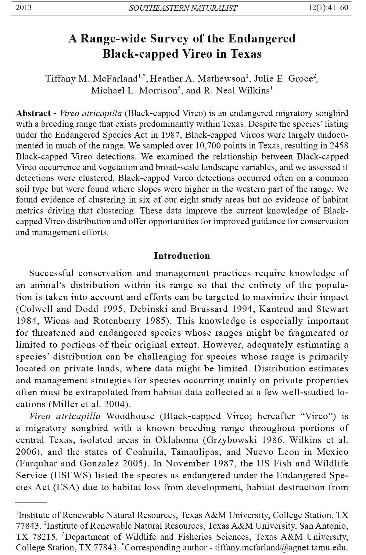
In 2010, we selected 8 study areas that were scattered across the breeding range
of the Vireo in Texas (Fig. 1): (1) Devil’s River: Devil’s River State Natural Area,
(2) Kickapoo: Kickapoo Caverns State Park and surrounding private properties,
(3) Devil’s Sinkhole: private properties surrounding Devil’s Sinkhole State
Natural Area, (4) Kerr: private properties surrounding Kerr Wildlife Management
Area (WMA), (5) Mason: private properties surrounding Mason Mountain WMA,
(6) Balcones: Balcones Canyonlands National Wildlife Refuge and surrounding
private properties, (7) Fort Hood: Fort Hood Military Reservation and nearby private
properties, and (8) Taylor: private properties in Taylor County. We chose the
first 7 of these locations based on known occurrence of Vireos, as determined by
our surveys in 2009 or concurrent research. We included an additional location,
Taylor, to expand our sampling in the north-central portion of the range (Fig. 1).
Within each of the 8 study areas, we focused on a central location and attempted to
gain as much contiguous property access at, and around, that location as possible,
including both public and private lands. This sampling strategy allowed us to more
thoroughly investigate the possibility that groups of birds were non-randomly distributed
over potentially suitable habitat.
Field surveys
We surveyed during the breeding season (1 April–30 June) in 2009 and
2010 from sunrise to 13:00. Our primary objective was to document presence
or absence of Vireos at each property rather than provide rigorous abundance
estimates. For both years of surveys, we avoided areas of open pasture or dense
woodlands (i.e., <1% or >85% canopy cover) while surveying. We surveyed all
potential habitat on each property over the course of 1 to 4 days depending on
2013 T.M. McFarland, H.A. Mathewson, J.E. Groce, M.L. Morrison, and R.N. Wilkins 45
the size of the property. We did not survey during inclement weather (e.g., excessive
rain or wind >20 km/h), or any other conditions (e.g., fog) that would inhibit
our ability to detect the birds. We required all observers to show proficiency in
identifying Vireo by sight and sound before conducting surveys.
During the randomly distributed surveys in 2009, two observers conducted
auditory and visual surveys for Vireos within each accessible property or along a
fence line in the case of roadway surveys. Both observers covered the same area
but did so separate from each other (e.g., starting on opposite sides of a property).
They traversed the property slowly and systematically, stopping every 20 minutes
for a 5-minute point survey, and recorded all Vireos detected while traversing
the property or during the point survey. When Vireos were detected, observers
walked to within 5 m of each Vireo and recorded its location using a handheld
GPS unit.
For the area-focused surveys in 2010, we created a grid of points (300 m x
300 m) that covered all accessible properties in each of our 8 study areas. We
conducted a 5-minute auditory and visual survey at each point with 1 observer
and recorded distance (≤100 m and >100 m) and direction to each Vireo detected
from that point. In addition, we recorded Vireo locations detected while walking
between points. We plotted all Vireo detections using ArcMap. Therefore, our
methods yielded point-survey locations and actual Vireo locations in 2009 and
resulted in point-survey locations and estimated Vireo locations in 2010.
Vegetation measurements
During our area-focused surveys, we measured vegetation characteristics at
each point-survey location to provide an index of vertical structure of woody
vegetation and an index for dispersion of woody vegetation (density of vegetation).
These metrics represent vegetative indices thought to influence Vireo
occurrence (e.g., presence of a browse-line; Grzybowski et al. 1994). We imagined
4 transects radiating from each point, with one transect oriented in the
direction of the closest woody vegetation (≥1 m tall) and subsequent transects
at 90°, 180°, and 270° from the first transect. For each transect direction, we
took measurements on the closest woody plant on that transect, using the dominant
plant if multiple plants occurred as a clump. Our vegetation measurements
yielded the following metrics: (1) average distance to vegetation: the average
distance from the survey point to the closest woody vegetation across the four
transects, (2) vegetation height at top: the average height of the woody vegetation
across the four transects estimated to the nearest meter, (3) vegetation
height at bottom: the average height of the lowest foliage cover of the woody
vegetation across the four transects estimated to the nearest 0.1 m, (4) oak index:
the number of transects along which an oak species was the closest woody
vegetation to the survey point, and (5) juniper index: the number of transects
along which a juniper species was the closest woody vegetation to the survey
point. All observers received training in these vegetation measures prior to the
field season and were required to show proficiency.
46 Southeastern Naturalist Vol. 12, No. 1
Remote sensing and GIS
We quantified remotely sensed habitat characteristics at and around Vireo
detections and non-detection locations (defined below, see Analyses) using
geospatial analysis tools in ESRI ArcGIS 10 and data layers that provided information
on ecoregion, ecosite, and topography. We created a 100-m buffer around
Figure 1. Locations of Texas A&M 2010 area-focused study regions for Black-capped
Vireo surveys: 1) Devil’s River State Park and surrounding area, 2) Kickapoo Caverns
State Park and surrounding area, 3) Devil’s Sinkhole State Park and surrounding
area, 4) Kerr Wildlife Management Area and surrounding area, 5) Mason County area,
6) Balcones Canyonlands National Wildlife Refuge and surrounding area, 7) Fort Hood
Military Reservation and surrounding area, and 8) Taylor County area. Black-capped
Vireo breeding range is outlined in red as suggested for revision by the Population and
Habitat Viability Assessment Report (USFWS 1996).
2013 T.M. McFarland, H.A. Mathewson, J.E. Groce, M.L. Morrison, and R.N. Wilkins 47
each point within which to quantify the characteristics. The 100-m buffer approximated
the mean territory size of a Vireo (3 ha; range of mean territory sizes
= 1.5 to 3.6 ha; Graber 1961, Tazik 1991).
To categorize the buffered areas according to ecoregion and ecosite, we
used the Level III Ecoregions and the Natural Resources Conservation Service
(NRCS) ecological site description (ESD; NRCS 2010), respectively. For
locations where the ecosite was undefined in the ESD database, we referred
to the NRCS soil surveys for the ecosite description. In addition, we calculated
the proportion of the landscape within the 100-m buffer that was comprised
of a particular ecosite. Ecosites have not been mapped for some areas in the
western part of the range; thus, the Arizona/New Mexico Mountains ecoregion
and much of the Chihuahuan Desert ecoregion are not included in the ecosite
analyses, accounting for the smaller sample size in the Chihuahuan Desert
ecoregion for these analyses.
We used the USGS National Elevation Dataset 1/3 arc-second digital elevation
models (DEM; 10-m resolution) to derive slope (degrees), planimetric
curvature (degrees/100 m), and profile curvature (degrees/100 m) for each 100-m
buffer, which indicates the convexity or concavity of the slope (Carson and
Kirkby 1972, Schmidt et al. 2003). Profile curvature is the rate of change of slope
gradient in the direction of greatest change, where positive values are vertically
concave and negative values are vertically convex (Carson and Kirkby 1972,
Schmidt et al. 2003). A profile curvature value of zero means the slope is flat
(Fig. 2). Planimetric curvature is the rate of change of direction of a contour line,
or horizontal convexity (Carson and Kirkby 1972, Schmidt et al. 2003). Positive
values for planimetric curvature are horizontally convex (water-diverging slopes)
Figure 2. Depictions of profile and planimetric curvature values when the values are positive,
zero, or negative. The black arrows indicate the path of objects travelling downhill.
Figure adapted from the ESRI support site mapping center (http://blogs.esri.com/Support/
blogs/mappingcenter/archive/2010/10/26/Understanding-Curvature-Rasters.aspx).
48 Southeastern Naturalist Vol. 12, No. 1
and negative values are horizontally concave (water-collecting slopes; Fig. 2).
From a hydrological standpoint, profile curvature affects the acceleration or deceleration
of flow across the land’s surface, while planimetric curvature affects
the dispersion of water as it flows downhill. Thus, these metrics indicate where
water collects and flows, which could influence both the plant growth and food
availability for the Vireo.
Anaylses
For analyses of the 2009 randomly distributed surveys, we defined detections
as actual Vireo locations, while we defined non-detections as survey points
where we did not detect Vireos within 200 m. For the 2010 area-focused surveys,
for the gridded survey points, if we detected a Vireo within 100-m of the point,
we defined the 100-m buffer surrounding each point as detections, regardless of
whether we detected the Vireo during a point survey or while moving between
points. We defined non-detections as 100-m buffers surrounding survey points
where we did not detect Vireos within 100 m of the point.
The two independent but simultaneous surveyors in 2009 resulted in the possibility
of each surveyor recording the same bird separately (i.e., 2 location points
for the same individual). To reduce the potential of including a single bird twice
in the analysis, we subset the 2009 detection points by including in the analysis
only those bird locations that were >200 m from each other. We also included
in the analysis a subset of non-detection points that fell >200 m from other nondetection
points in order to prevent the area of analysis within the 100-m buffers
from overlapping.
We report results based on ecoregion for our randomly distributed 2009 surveys
and by study area for our 2010 area-focused surveys. We only considered
ecosites that were represented in ≥10% of all buffered areas in a study area or that
covered ≥10% of the area within the buffers. We compared means using t-tests
to determine differences in ecosite proportions, remotely-sensed metrics, and
vegetation metrics (2010 only) between detection and non-detection locations for
each year. We report only statistically significant comparisons.
Spatial distribution
To determine whether Vireos were randomly distributed within our 2010
study areas, we used the centroids of the detection and non-detection buffer locations,
spaced at 300 m, and assigned detections a value of 1 and non-detections a
value of 0. For each of the 8 study areas, we first tested if the pattern of detections
and non-detections was clustered, dispersed, or random using Global Moran’s I
statistic. The Global Moran’s I statistic provides an index value between -1 and 1
and is interpreted similar to Pearson’s correlation coefficient, with negative values
indicating negative spatial autocorrelation, positive values indicating positive
spatial autocorrelation, and values near 0 indicating no spatial autocorrelation
(Fortin and Dale 2005). Next, if we detected positive spatial autocorrelation in
a study area, we ran a cluster analysis in ArcMap Spatial Statistics (ESRI) using
the high/low clustering tool (Getis-ord general G function; Getis and Ord 1992),
to determine if detections, or non-detections were aggregated. For both tests, we
2013 T.M. McFarland, H.A. Mathewson, J.E. Groce, M.L. Morrison, and R.N. Wilkins 49
used row standardization where spatial weights are divided by the sum of the
weights of all neighboring survey points.
To determine whether the vegetation or remote-sensing metrics were associated
with observed aggregation, we compared the spatial clustering test results
with box-plots of each metric. If the spatial analysis indicated that Vireos were
aggregated and if box-plots demonstrated obvious differences in the metrics
for Vireo detections and non-detections, then we cannot separate clustering of
the Vireos from clustering of the habitat because Vireos might be clustering at a
different scale than we are examining (Fig. 3). However, if the Vireo detections
were spatially clustered but box-plots suggest no obvious differences in any of
our metrics between detections and non-detections, then we could reasonably
conclude that either the Vireos are aggregating on the landscape for a reason
other than habitat availability, or that our metrics are not appropriate for distinguishing
between habitat and non-habitat (Fig. 3).
Results
Survey data
In 2009, we surveyed for Vireos within 282 survey squares, on approximately
300 randomly distributed properties in 57 counties and 6 ecoregions in central
and west Texas, and detected Vireos in 25 counties (Fig. 4). Roadside surveys
were conducted in addition to property surveys in 3 counties. We recorded 460
Figure 3. Concept behind clustering analysis and the relation to differences between
detection and non-detection locations to get at the underlying cause of clustering. Large
circles represent area surveyed. Only when the spatial analysis shows aggregation but no
differences are found between detection and non-detection locations can we show evidence
that Vireo are clustering for a reason other than habitat, as measured by our metrics.
50 Southeastern Naturalist Vol. 12, No. 1
Vireo detections at 11% (n = 4056) of the 5-min survey points. The subset of
data used in the habitat comparisons included 2322 point-count locations (nondetection
points) and 251 Vireo detections (Table 1).
In 2010, we surveyed 6207 survey points on approximately 100 properties
within our 8 study areas; surveys occurred across 14 counties and 6 ecoregions.
We detected Vireos within 100 m of 942 survey points (Table 2). The percent of
Figure 4. Results from Texas A&M 2009 Black-capped Vireo surveys. Sampling occurred
in 57 counties in 8 different ecoregions across the range. Area outlined in red indicates the
Vireo’s breeding range in Texas as suggested for revision by the Population and Habitat
Viability Assessment Report (USFWS 1996).
2013 T.M. McFarland, H.A. Mathewson, J.E. Groce, M.L. Morrison, and R.N. Wilkins 51
survey points with detections within our 8 study areas generally decreased from
27% in the west to 9.4% in the east (Table 2).
Remote sensing and GIS
Two main ecosites, Low Stony Hill and Steep Rocky, made up large a percent
(>10% each) of the area within our buffers in both years of study (Figs.
1, 5). Low Stony Hill is characterized by relatively gentle slopes (<7°) and
shallow, well-drained, moderately permeable soils, whereas Steep Rocky is
characterized by similar soils but steep slopes (>7°; NRCS 2010). From our
2009 survey data, a higher average proportion of the detection buffers was
comprised of Low Stony Hill than all buffers combined (i.e., available) across
the three ecoregions (Fig. 5). However, our 2010 survey results indicated that
Low Stony Hill was represented at points with Vireo detections more than
Table 1. Number of points visited and number of Black-capped Vireo detections by Level III
ecoregion (based on Omernik 1987) during 2009 randomly distributed surveys. For analyses of
detections and non-detections, we used a subset of all points visited (non-detections) and detections
where all points were >200 m from each other.
Total Subset (>200 m)
Vireo Survey points Vireo locations
Ecoregion Survey points locations (non-detections) (detections)
Edwards Plateau 1945 355 1139 197
Cross Timbers 1007 51 469 27
Chihuahuan Deserts 688 35 493 24
Central Great Plains 288 19 156 3
Arizona/New Mexico Mountains 115 0 57 0
Southwestern Tablelands 13 0 8 0
Total 4056 460 2322 251
Table 2. Number of 100-m buffers surveyed, number of recorded Vireo detections, and percent of
buffers with detections by study area during our surveys in 2010. Buffered points were on a 300-m
x 300-m grid; buffers with a Vireo detection recorded within them were defined as detections,
whereas those with no Vireo detections were defined as non-detections. Study areas are listed from
west to east.
100-m buffers surveyed Percent of
Recorded buffers with
Study area Detections Non-detections Total detections detections
Devil’s River 176 476 652 417 27.0%
Kickapoo 249 760 1009 443 24.7%
Devil’s Sinkhole 21 440 461 48 4.6%
Kerr 222 1069 1291 389 17.2%
Mason 6 104 110 18 5.5%
Taylor 6 32 38 23 15.8%
Balcones Canyonlands 71 538 609 207 11.7%
Fort Hood 191 1846 2037 453 9.4%
Total 942 5265 6207 1998 15.2%
52 Southeastern Naturalist Vol. 12, No. 1
available at three of the study areas toward the eastern portion of the range
(Kerr, Balcones, and Fort Hood) but was represented at detections less than
available for the most western study region, Devil’s River. No significant difference
was detected for the other study areas (Fig. 5).
For our 2009 survey data, Steep Rocky was present only at points in the Edwards
Plateau ecoregion, and detection buffers had higher average proportions
of Steep Rocky than all buffers combined (Fig. 5). For the 2010 survey locations,
detection buffers had higher average proportion of Steep Rocky than all buffers
combined for our three western study areas, whereas this ecosite occurred in few,
if any, of the central and eastern study areas (Figs. 1, 5).
Several other ecosites differed significantly between Vireo detections and nondetections.
The ecosite Draw, which is associated with perennial streams (NRCS
2010), was significantly higher by 58% (absolute percent) at detections than at
non-detections in the Chihuahuan Desert (t391 = 6.3, P < 0.001). Only 12% of the
total area surveyed in the Chihuahuan Desert ecoregion was categorized as Draw,
but Draw made up almost 70% of the area within each detection buffer, on average.
For our 2010 data, Adobe, an upland ecosite characterized by shallow, gravelly,
droughty soils and slopes ranging from 0 to 12° (NRCS 2010), showed
Figure 5. Average proportions of Low Stony Hill and Steep Rocky within 100-m
buffers surrounding Black-capped Vireo detection points, non-detection points, and
across all points, by ecoregion for surveys conducted in 2009 and for each study area
surveyed in 2010. While the white bars (for total area) represent the availability of
each ecosite within the study area, the t-tests compared the means between detection
and non-detection points.
2013 T.M. McFarland, H.A. Mathewson, J.E. Groce, M.L. Morrison, and R.N. Wilkins 53
significant differences at three of the eastern study areas, and detection buffers
had higher average proportion Adobe than all buffers combined at Mason and
Fort Hood (Fig. 6). Additionally, the proportion of Shallow ecosite, characterized
by shallow soils with moderate slopes and low water-holding capacity,
was significant but lower at detections than non-detections Kickapoo (t1007 =
3.7, P < 0.001), composing only 6% on average of area within detection buffers
and 13% on average of areas within non-detection buffers. Proportion of
the ecosite Clay Loam, characterized by flat slopes and fertile soil with high
water-holding capacity, was significantly different between detections and
non-detections at Balcones (t607 = 2.9, P = 0.003), but Clay Loam was not present
in any detection buffers and composed only 7% on average of area within
non-detection buffers.
For the 2010 surveys, Vireo detections were associated with significantly
steeper slopes at Devil’s River, Kickapoo, Devil’s Sinkhole, Mason, and Fort
Hood, while Vireos were associated with less steep slopes at Balcones.
For our 2009 surveys, mean profile curvature was significantly different between
Vireo detections and non-detections in the Edwards Plateau, where slopes
at detection locations were slightly more concave (Table 3). For our 2010 data,
profile curvature was significantly different only at Devil’s River, where slopes
were again more concave at detection locations (Table 4). Planimetric curvature
was significantly different between detection and non-detection points only in the
Cross Timbers ecoregion, where detections were on water-collecting (horizontally
concave) slopes (Table 3).
Figure 6. Average proportions of Adobe ecosite (NRCS 2010) within 100-m buffers
surrounding Black-capped Vireo detection points, non-detection points, and across all
points, by study area surveyed in 2010. While the white bars (for total area) represent the
availability of each ecosite within the study area, the t-tests compared the means between
detection and non-detection points.
54 Southeastern Naturalist Vol. 12, No. 1
Vegetation measurements
Although the 2010 survey data suggested several statistically significant differences
between Vireo detections and non-detections within three study regions,
the differences may not represent biological differences (Table 4). For example,
the differences in vegetation height-at-top and height-at-bottom never differed by
more than 0.5 m within any study area, and the distance to vegetation from the
Table 4. Results of significant (P < 0.006, Bonferroni adjusted) t-tests between detections and
non-detections (including means and standard errors) during the 2010 area-focused surveys for
remote-sensing metrics averaged over a 100-m radius and local vegetation metrics taken around
each point. Study sites are listed in a general southwestern to northeastern order.
Detection Non-detection
n Mean SE n Mean SE P
Devil’s River
Slope 176 13.78 0.45 476 11.86 0.30 0.001
Profile curvature 176 0.10 0.02 476 -0.03 0.01 <0.001
Veg height - Top 174 2.04 0.06 468 1.79 0.03 <0.001
Oak index 174 0.22 0.04 468 0.08 0.01 <0.001
Kickapoo
Slope 249 8.79 0.27 760 7.55 0.16 <0.001
Veg height - top 242 2.64 0.05 754 3.02 0.04 <0.001
Veg height - bottom 242 0.16 0.02 754 0.23 0.01 0.004
Juniper index 242 1.65 0.08 754 1.92 0.05 0.005
Devil’s Sinkhole
Slope 21 9.50 1.36 440 5.60 0.26 0.002
Kerr
Dist. to veg 222 7.76 0.38 1069 9.25 0.22 0.004
Veg height - top 222 3.21 0.08 1069 3.85 0.05 <0.001
Veg height - bottom 222 0.33 0.03 1069 0.62 0.02 <0.001
Mason
Slope 6 4.86 0.94 104 2.61 0.14 0.001
Balcones
Slope 71 2.76 0.33 538 5.39 0.18 <0.001
Fort Hood
Slope 191 4.65 0.25 1846 3.56 0.07 <0.001
Table 3. Results of significant (P < 0.013, Bonferroni adjusted) t-tests between Black-capped
Vireo detection and non-detection points (including means and standard errors) for remote sensing
metrics averaged over a 100-m radius circle. Data is from the 2009 randomly distributed surveys.
Detection Non-detection
n Mean SE n Mean SE P
Edwards Plateau
Profile curvature 197 0.08 0.01 1139 0.03 0.00 <0.001
Cross Timbers
Profile curvature 27 -0.03 0.01 469 0.01 0.00 0.006
Planimetric curvature 27 -0.03 0.01 469 0.01 0.00 <0.001
2013 T.M. McFarland, H.A. Mathewson, J.E. Groce, M.L. Morrison, and R.N. Wilkins 55
survey point differed between detections and non-detections by approximately 1
m at Kerr (Table 4).
Spatial distribution
The results of the Getis-ord General G test indicated that the Vireo detection
points were clustered (P < 0.006, Bonferroni adjusted; Miller 1981) at all study
areas except Devil’s River, Devil’s Sinkhole, and Taylor County (Table 5). We
further determined for Devil’s River and Devil’s Sinkhole that the clustering of
both detections as well as non-detections were not the cause of the insignificant
P-values, as the Moran’s I test indicated no clustering was occurring (Devil’s
River z-value = 0.479, P = 0.532, Devil’s Sinkhole z-value = 0.270, P = 0.787)
However, a Moran’s I test for Taylor County results showed a clustering of both
detections and non-detections (z-value = 3.115, P = 0.002).
Comparing these results to our remote-sensing and vegetation t-tests and
associated box plots, we found the metrics showed extensive overlap between
detections and non-detections. Slope was the only metric with some difference
between detections and non-detections at Balcones, but the average
difference was only about 2° (Fig. 7). Sample sizes at Mason and Taylor were
too small to draw any conclusions.
Discussion
Using two different strategies for surveying Vireo and describing areas they
occupy, our study indicated that while Vireos were rare when surveying across
the range, particularly in the western portion of the range, Vireos were locally
more abundant within our study areas in the west than in the east. The proportion
of survey points from our area-focused surveys that had detections generally
increased within our study areas from east to west. However, the results of our
randomly distributed surveys showed only a few concentrations of Vireos west
of the Devil’s River area.
The effect of Low Stony Hill and Steep Rocky ecosites showed a gradient
from east to west. Both ecosites, which have a common soil type and differ only
Table 5. Results of the Getis-ord General G test to determine clustering of the Vireo detections
within each of our eight 2010 study areas. Clustering was indicated in all study areas except Devil’s
Sinkhole and Devil’s River, where the analysis indicated the pattern was not statistically different
from random.
General G
Study area Observed Expected Z-value P-value
Devil’s River 0.002 0.002 0.475 0.634
Kickapoo 0.002 0.001 11.695 less than 0.001
Devil’s Sinkhole 0.003 0.002 0.354 0.723
Taylor County 0.072 0.027 2.120 0.034
Kerr 0.002 0.001 12.677 less than 0.001
Mason County 0.039 0.008 11.069 less than 0.001
Balcones 0.004 0.002 17.758 less than 0.001
Fort Hood 0.001 0.000 33.654 less than 0.001
56 Southeastern Naturalist Vol. 12, No. 1
in slope, are clearly associated with Vireo occurrence, but Steep Rocky was used
more often in western survey areas where both ecosites occur (Fig. 1). Although
we did not find an obvious pattern between Vireo occurrence and slope, our data
show that this soil type is used by Vireos when it occurs on slopes in the west and
on more level areas in the eastern parts of the range. However, Vireos were generally
detected on slightly greater slopes in 2010 in all study areas except Balcones.
Vireo breeding habitat in Mexico is described as rocky slopes with shallow soils,
consistent with our western study area results (Farquhar and Gonzalez 2005,
Figure 7. Box plots of average slope at each study site, comparing differences between
detections and non-detections. Sample sizes are too small in Mason and Taylor to draw
any conclusions from the differences. Average slope at Balcones differed with relatively
little overlap, but the difference is only 2°, which is probably not biologically relevant.
Boxplots for other metrics showed a similar inability to differentiate between detections
and nondetections.
2013 T.M. McFarland, H.A. Mathewson, J.E. Groce, M.L. Morrison, and R.N. Wilkins 57
Graber 1961). Soil types have been used to help delineate avian habitat (Gottschalk
et al. 2005, Vander Haegen et al. 2000), but ecosites have only recently
been investigated for use in avian studies (Marshall 2011).
Differences in climate could help account for these east–west gradients in the
proportion of occupied survey points and the effect of ecosite. As the climate becomes
more arid from east to west, where and how vegetation grows will differ.
Vegetation types that would grow on flatter areas in the east may only grow in
drainages where water collects in the west, where rainfall is much lower. Similarly,
soils with higher runoff would be more likely to support smaller vegetation
in the west as compared to the east where there is more rainfall. Additionally,
from east to west, the dominant vegetation differs in species composition, climax
states, and structural characteristics. For example, climax vegetation in the west
is predominately shrubs due in part to lack of rainfall compared to the east where
the climax vegetation can become tall and dense woodland in the absence of natural
or man-made disturbances (e.g., fire). Therefore, Vireo habitat is maintained
without disturbance in the west (Farquhar and Gonzalez 2005) and requires
disturbance in the east (Grzybowski et al. 1984). However, once the climate
becomes too arid, the vegetation requirements for potential Vireo habitat can no
longer be supported. This factor may explain the relative lack of detections farther
west than the Devils River study area. Detections in the Chihuahuan Desert
ecoregion were either in areas of higher elevation where the climate would be
less arid, such as in the Chisos Mountains of the Big Bend area or in drainages
where water collects and could support more vegetation.
Although there were some statistically significant differences between Vireo
detections and non-detections in the study regions, vegetation characteristics
were generally similar. We also found substantial overlap in the remotely sensed
spatial metrics. Although the t-tests were significant, the box plots showed no
distinct separation between areas with Vireo detection or non-detection. Further,
the results of our spatial cluster analysis showed that Vireo detection points were
spatially aggregated in all locations except Devil’s River and Devil’s Sinkhole,
although the small sample sizes in Mason and Taylor make those results inconclusive.
It is possible that the metrics we examined are not capturing a difference
that the Vireos are cueing in on (e.g., food availability).
However, these results lend support to the idea that Vireos are clustering on
the landscape and not occupying all potential habitat, potentially a product of
conspecific attraction (Ward and Schlossberg 2004). Future work will further
assess the Vireo aggregations to determine how the Vireos distribute themselves
within areas at finer spatial scales in relation to each other and in relation to different
habitat variables.
While many of our metrics showed significant differences between detection
and non-detection locations within most of the ecoregions and study areas,
we did not find many significant patterns across regions or across years. These
results could be because our metrics were not appropriate for defining habitat
or because Vireo habitat is so diverse across the range, it is just inherently difficult
to measure or predict. Additionally, our metrics might be poor predictors
58 Southeastern Naturalist Vol. 12, No. 1
of habitat when considered individually, but some combination of metrics might
be more predictive of Vireo habitat. Future efforts will investigate multivariate
analysis of our metrics and attempt to model habitat rangewide.
The ability to link Vireo occurrence and remotely sensed metrics such as soil
type (using ecosites) allows us to estimate Vireo distribution and begin to map
potential habitat within the range of the Vireo, providing better guidance for
conservation and management efforts. Additionally, the potential that Vireo are
clustering due to conspecific attraction could account for the apparent rangewide
rarity of Vireo yet local frequency of detections found during our surveys,
and this clustering has implications for management (Ahlering and Faaborg
2006). For instance, management practices that create new Vireo habitat may
be more successful in recruiting Vireos if located adjacent to occupied habitat.
Additional information is needed to determine how Vireo will disperse from
one season to the next to further determine the implications of this clustering
behavior and to predict habitat occupancy if new habitat is created.
Acknowledgments
Special thanks to the Texas Department of Transportation and Dr. Cal Newnam for
making this research possible. The Texas Parks and Wildlife Department, the US Fish
and Wildlife Service, the Nature Conservancy, the City of Austin, the Lower Colorado
River Authority, the Army Corps of Engineers, Travis County parks, Fort Hood Military
Installation, and numerous private landowners permitted us access to their properties.
Literature Cited
Ahlering, M.A., and J. Faaborg. 2006. Avian habitat management meets conspecific attraction:
If you build it, will they come? Auk 123:301–312.
Block, W.M., and L.A. Brennan. 1993. The habitat concept in ornithology: Theory and
applications. Current Ornithology 11:35–91.
Carson, M., and M. Kirkby. 1972. Hillslope Form and Process. Cambridge University
Press, Cambridge, UK. 484 pp.
Collier, B.A., M.L. Morrison, S.L. Farrell, A.J. Campomizzi, J.A. Butcher, K.B. Hays,
D.I. MacKenzie, and R.N. Wilkins. 2010. Monitoring Golden-cheeked Warblers on
private lands in Texas. Journal of Wildlife Management 74:140–147
Collier, B.A., J.G. Groce, M.L. Morrison, J.C. Newnam, A.J. Campommizzi, S.L. Farrell,
H.A. Mathewson, R.T. Snelgrove, R.J. Carroll, and R.N. Wilkins. 2012. Predicting
patch occupancy in fragmented landscapes at the rangewide scale for an endangered
species: An example of an American warbler. Diversity and Distributions 18:158–167
Colwell, M.A., and S.L. Dodd. 1995. Waterbird communities and habitat relationships in
coastal pastures of Northern California. Conservation Biology 9:827–834.
Dall, S.R.X., L.A. Giraldeau, O. Olsson, J.M. McNamara, and D.W. Stephens. 2005.
Information and its use by animals in evolutionary ecology. Trends in Ecology and
Evolution 20:187–190.
Danchin, E., and D.H.B. Doligez. 2001. Public information and breeding-habitat selection.
Pp. 243–258, In J. Clobert, E. Danchin, A.A. Dhondt, and J.D. Nichols (Eds.).
Dispersal. Oxford University Press, Oxford, UK. 480 pp.
Debinski, D.M., and P.F. Brussard. 1994. Using biodiversity data to assess species-habitat
relationships in Glacier National Park, Montana. Ecological Applications 4:833–843.
2013 T.M. McFarland, H.A. Mathewson, J.E. Groce, M.L. Morrison, and R.N. Wilkins 59
DeBoer, T.S., and D.D. Diamond. 2006. Predicting presence-absence of the endangered
Golden-cheeked Warbler (Dendroica chrysoparia). Southwestern Naturalist
51:181–190.
Farquhar, C.C., and J.I. Gonzalez. 2005. Breeding habitat, distribution and population
status of the Black-capped Vireo in Northern Mexico. Final Report. Project WER 65.
Submitted to Texas Parks and Wildlife as required by The Endangered Species Program,
Grant No.E-17 Endangered and Threatened Species Conservation. Austin, TX.
Fortin, M.J., and M. Dale. 2005. Spatial analysis of sample data. Pp. 111–173, In M.J.
Fortin and M. Dale (Eds.). Spatial Analysis: A Guide for Ecologists. Cambridge University
Press, Cambridge, UK. 392 pp.
Getis, A., and J.K. Ord. 1992. The analysis of spatial association by use of distance statistics.
Geographical Analysis 24:190–206.
Gottschalk, T.K., F. Huettmann, and M. Ehlers. 2005. Thirty years of analysing and modeling
avian habitat relationships using satellite imagery data: A review. International
Journal of Remote Sensing 26:2631–2656.
Graber, J.W. 1961. Distribution, habitat requirements, and life history of the Blackcapped
Vireo (Vireo atricapilla). Ecological Monographs 31:313–336.
Grzybowski, J.A. 1986. Population and nesting ecology of the Black-capped Vireo (Vireo
atricapillus). Interim Report. Office of Endangered Species, US Fish and Wildlife
Service, Albuquerque, NM.
Grzybowski, J.A. 1995. Black-capped Vireo (Vireo atricapillus). Pp. 1–24, In A. Poole
and F. Gill (Eds.). The Birds of North America, No. 181. The Academy of Natural
Sciences, Philadelphia, Pennsylvania, and The American Ornithologists’ Union,
Washington, DC.
Grzybowski, J.A., D.J. Tazik, and G.D. Schnell. 1994. Regional analysis of Blackcapped
Vireo breeding habitats. The Condor 96:512–544.
Hilden, O. 1965. Habitat selection in birds. Annales Zoologici Fennici 2:53–75.
Hilty, J., and A.M. Merenlender. 2003. Studying biodiversity on private lands. Conservation
Biology 17:132–137.
Jones, J. 2001. Habitat selection studies in avian ecology: A critical review. Auk
118:557–562.
Juarez, E.A. 2004. Habitat relationships of seven breeding bird species in the Leon River
Watershed investigated at local scales. M.Sc. Thesis. Texas A&M University, College
Station, TX. 113 pp.
Kantrud, H.A., and R.E. Stewart. 1984. Ecological distribution and crude density of
breeding birds on prairie wetlands. The Journal of Wildlife Management 48:426–437.
Magness, D.R. 2003. Breeding and wintering bird occurrence in Texas rangelands with
special reference to woody plant encroachment. M.Sc. Thesis. Texas A&M University,
College Station, TX. 91 pp.
Maresh, J., and G.A. Rowell. 2000. Performance report: Project WER61, census and
monitoring of Black-capped Vireo in Texas. Submitted to Texas Parks and Wildlife
as required by The Endangered Species Program, Grant No.E-1-12 Endangered and
Threatened Species Conservation. Austin, TX.
Marshall, M.E. 2011. Effects of tree species composition and foraging effort on the productivity
of Golden-cheeked Warblers. M.Sc. Thesis. Texas A&M University, College
Station, TX. 58 pp.
Marshall, J.T., Jr., R.B. Clapp, and J.A. Grzybowski. 1985. Status report: Vireo atricapillus
Woodhouse, Black-capped Vireo. Unpublished report to Office of Endangered
Species, US Fish and Wildlife Service. Albuquerque, NM.
Mathewson, H.A., J.E. Groce, T.M. McFarland, B.A. Collier, M.L. Morrison, and R.N.
Wilkins. 2012. Estimating breeding season abundance of Golden-cheeked Warblers
in Texas. Journal of Wildlife Management 76:1117–1128.
60 Southeastern Naturalist Vol. 12, No. 1
Miller, R.G. 1981. Simultaneous Statistical Inference. Springer-Verlag, New York, NY.
299 pp.
Miller, J.R., M.G. Turner, E.A. Smithwick, C.L. Dent, and E.H. Stanley. 2004. Spatial
extrapolation: The science of predicting ecological patterns and processes. BioScience
54:310–320.
Natural Resources Conservation Service (NRCS). 2010. Ecological Site Description
(ESD) database. Available online at http://esis.sc.egov.usda.gov/ESIS/. Accessed 1
August 2010.
Omernik, J.M. 1987. Ecoregions of the conterminous United States. Map (scale
1:7,500,000). Annals of the Association of American Geographers 77:118–125.
Ratzlaff, A. 1987. Endangered and threatened wildlife and plants: Determination of the
Black-capped Vireo to be an endangered species. Federal Register 52:37420–37423.
Schmidt, J., I.S. Evans, and J. Brinkman. 2003. Comparison of polynomial models for
land-surface curvature calculation. International Journal of Geographical Information
Science 17:797–814.
Sorice, M.G., W. Haider, J.R. Conner, and R.B. Ditton. 2011. Incentive structure of and
private landowner participation in an endangered species conservation program. Conservation
Biology 25:587–596.
Stevens, D.L., and S.F. Jensen. 2007. Sample design, execution, and analysis for wetland
assessment. Wetlands 27:515–523.
Tazik, D.J. 1991. Proactive management of an endangered species on army lands: The
Black-capped Vireo on the land of Fort Hood, Texas. Ph.D. Dissertation. University
of Illinois, Urbana-Champaign, IL. 247 pp.
US Fish and Wildlife Service (USFWS). 1996. Black-capped Vireo population and
habitat viability assessment report. Report of a September 18–21, 1995 workshop
in partial fulfillment of US Biological Service Grant No. 80333-1423. US Fish and
Wildlife Service. Austin, TX.
Valone, T.J. 1989. Group foraging, public information, and patch estimation. Oikos
56:357–363.
Vander Haegen, W.M., F.C. Dobler and D.J. Pierce. 2000. Shrubsteppe bird response to
habitat and landscape variables in eastern Washington, USA. Conservation Biology
14:1145–1160.
Ward, M.P., and S. Schlossberg. 2004. Conspecific attraction and the conservation of
territorial songbirds. Conservation Biology 18:519–525.
Wiens, J.A., and J.T. Rotenberry. 1985. Response of breeding passerine birds to rangeland
alteration in a North American shrubsteppe locality. Journal of Applied Ecology
22:655–668.
Wilkins, N., R.A. Powell, A.T. Conkey, and A.G. Snelgrove. 2006. Population status and
threat analysis for the Black-capped Vireo. Department of Wildlife and Fisheries Science,
Texas A&M University, College Station, TX.


 The Southeastern Naturalist is a peer-reviewed journal that covers all aspects of natural history within the southeastern United States. We welcome research articles, summary review papers, and observational notes.